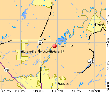
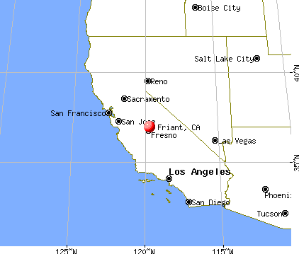
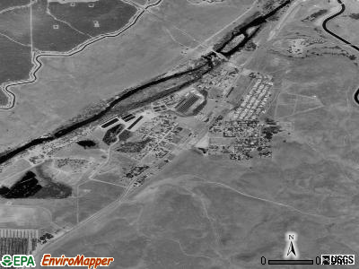
Friant, California
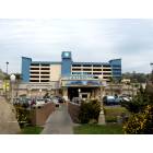
Friant: Table Mountain Rancheria's - Table Mountain Casino
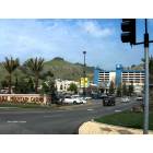
Friant: Table Mountain Casino - Millerton Road between Sky Harbour Rd and Table Mountain Rd
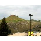
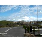
Friant: Hill top land sale, overlooking Table Mountain Casino
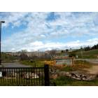
Friant: Friant Cove with Friant Dam in the background
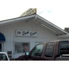
Friant: The Dam Diner, a nice place to eat in Friant, with a view of the Friant Dam
Friant: Friant Dam on the San Joaquin River, constructed in 1944, creating the Millerton Lake
- add
your
Submit your own pictures of this place and show them to the world
- OSM Map
- General Map
- Google Map
- MSN Map
Population change since 2000: -1.9%
| Males: 132 | |
| Females: 377 |
| Median resident age: | 51.2 years |
| California median age: | 37.9 years |
Zip codes: 93626.
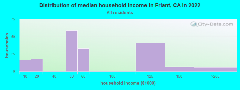
| Friant: | $50,861 |
| CA: | $91,551 |
Estimated per capita income in 2022: $38,043 (it was $17,878 in 2000)
Friant CDP income, earnings, and wages data
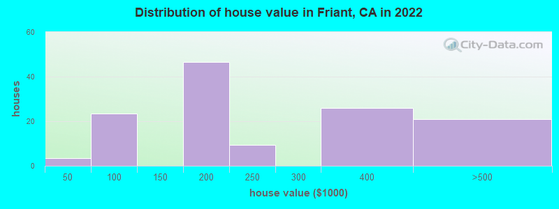
Estimated median house or condo value in 2022: $197,584 (it was $74,300 in 2000)
| Friant: | $197,584 |
| CA: | $715,900 |
Mean prices in 2022: all housing units: $225,199; detached houses: $310,182; mobile homes: $181,347
Median gross rent in 2022: $1,131.
Detailed information about poverty and poor residents in Friant, CA

Compare current foreclosures near Friant, CA:
| Photo | Address | Area | Beds / Baths | Price | Details |
|---|---|---|---|---|---|

|
#1
Bluewater Bay Ln
Friant, CA 93626
|
1,440 sq. feet
|
2 baths 2 beds |
show details | |

|
#2
Sunset Dr
Friant, CA 93626
|
- sq. feet
|
- baths - beds |
show details | |

|
#3
Lago Bello Ln
Friant, CA 93626
|
- sq. feet
|
- baths - beds |
show details | |

|
#4
Dogwood Dr
North Fork, CA 93643
|
2,233 sq. feet
|
3 baths 3 beds |
$450,000
|
show details |

|
#5
Crystal Springs Ct
Coarsegold, CA 93614
|
2,311 sq. feet
|
6 baths 6 beds |
show details | |

|
#6
N Saratoga Ave
Fresno, CA 93722
|
1,234 sq. feet
|
2 baths 3 beds |
show details | |

|
#7
Ryan Ave
Clovis, CA 93611
|
2,133 sq. feet
|
3 baths 3 beds |
show details | |

|
#8
E Hedges Ave
Fresno, CA 93703
|
816 sq. feet
|
1 baths 2 beds |
show details | |

|
#9
Whittier Ave
Clovis, CA 93611
|
- sq. feet
|
2 baths 4 beds |
show details | |

|
#10
Prescott Ave
Clovis, CA 93619
|
2,191 sq. feet
|
2 baths 4 beds |
show details |
| Photo | Address | Area | Beds / Baths | Price | Details |
|---|---|---|---|---|---|

|
#11
Mckelvy Ave
Clovis, CA 93611
|
1,830 sq. feet
|
1 baths 4 beds |
show details | |

|
#12
E Woodhaven Ln
Fresno, CA 93720
|
2,213 sq. feet
|
3 baths 4 beds |
show details | |

|
#13
Kenmore Dr S
Fresno, CA 93703
|
1,094 sq. feet
|
1 baths 2 beds |
show details | |

|
#14
Monreal Rd
Madera, CA 93636
|
1,850 sq. feet
|
2 baths 3 beds |
show details | |

|
#15
N Mitre Ave
Fresno, CA 93722
|
1,293 sq. feet
|
2 baths 3 beds |
show details | |

|
#16
E Blue Ridge Rd
Fresno, CA 93720
|
2,640 sq. feet
|
3 baths 4 beds |
show details | |

|
#17
N Lodi Ave
Fresno, CA 93722
|
1,736 sq. feet
|
2 baths 3 beds |
show details | |

|
#18
East Berkeley Ave
Fresno, CA 93727
|
2,870 sq. feet
|
2 baths 5 beds |
show details | |

|
#19
S Winery Ave
Fresno, CA 93727
|
1,492 sq. feet
|
1 baths 4 beds |
show details | |

|
#20
E San Ramon Ave
Fresno, CA 93710
|
1,293 sq. feet
|
1 baths 3 beds |
show details |
| Photo | Address | Area | Beds / Baths | Price | Details |
|---|---|---|---|---|---|

|
#21
N Gregory Ave
Fresno, CA 93722
|
1,304 sq. feet
|
2 baths 3 beds |
show details | |

|
#22
Rd 603 Fka 35972 Road 603
Madera, CA 93638
|
1,512 sq. feet
|
2 baths 3 beds |
show details | |

|
#23
N Cornelia Ave
Fresno, CA 93722
|
1,754 sq. feet
|
2 baths 3 beds |
show details | |

|
#24
N Bengston Ave
Fresno, CA 93705
|
1,934 sq. feet
|
2 baths 4 beds |
show details | |

|
#25
E Lansing Way
Fresno, CA 93726
|
1,376 sq. feet
|
2 baths 3 beds |
show details | |

|
#26
W Chennault Ave
Fresno, CA 93722
|
1,304 sq. feet
|
2 baths 3 beds |
show details | |

|
#27
W Gettysburg Ave
Fresno, CA 93705
|
2,688 sq. feet
|
1 baths 3 beds |
show details | |

|
#28
W Millbrae Ave
Fresno, CA 93722
|
1,542 sq. feet
|
2 baths 3 beds |
show details | |

|
#29
W Menlo Ave
Fresno, CA 93722
|
1,390 sq. feet
|
2 baths 3 beds |
show details | |

|
#30
E Pontiac Way
Fresno, CA 93726
|
1,596 sq. feet
|
2 baths 3 beds |
show details |
| Photo | Address | Area | Beds / Baths | Price | Details |
|---|---|---|---|---|---|

|
#31
E Garland Ave
Fresno, CA 93726
|
2,216 sq. feet
|
2 baths 3 beds |
show details | |

|
#32
W Celeste Ave
Fresno, CA 93722
|
2,468 sq. feet
|
3 baths 4 beds |
show details | |

|
#33
E Griffith Way
Fresno, CA 93704
|
1,152 sq. feet
|
2 baths 3 beds |
show details | |

|
#34
E Andrews Ave
Fresno, CA 93726
|
1,785 sq. feet
|
2 baths 4 beds |
show details | |

|
#35
E Fedora Ave
Fresno, CA 93726
|
1,480 sq. feet
|
1 baths 3 beds |
show details | |

|
#36
W Fremont Ave
Fresno, CA 93722
|
1,719 sq. feet
|
2 baths 3 beds |
show details | |

|
#37
E Saginaw Way
Fresno, CA 93704
|
1,222 sq. feet
|
2 baths 3 beds |
show details | |

|
#38
W Acacia Ave
Fresno, CA 93705
|
1,848 sq. feet
|
2 baths 3 beds |
show details | |

|
#39
E Fedora Ave
Fresno, CA 93726
|
1,868 sq. feet
|
1 baths 3 beds |
show details | |

|
#40
N Mitre Ave
Fresno, CA 93722
|
1,219 sq. feet
|
2 baths 3 beds |
show details |
| Photo | Address | Area | Beds / Baths | Price | Details |
|---|---|---|---|---|---|

|
#41
W Santa Ana Ave
Fresno, CA 93705
|
1,384 sq. feet
|
2 baths 2 beds |
show details | |

|
#42
N Wolters Ave
Fresno, CA 93726
|
1,456 sq. feet
|
2 baths 3 beds |
show details | |

|
#43
N Carruth Ave
Fresno, CA 93705
|
2,383 sq. feet
|
2 baths 3 beds |
show details | |

|
#44
W Fir Ave
Fresno, CA 93722
|
1,672 sq. feet
|
2 baths 3 beds |
show details | |

|
#45
W San Ramon Ave
Fresno, CA 93711
|
1,772 sq. feet
|
2 baths 3 beds |
show details | |

|
#46
E Bellaire Way
Fresno, CA 93726
|
1,102 sq. feet
|
1 baths 3 beds |
show details | |

|
#47
Bellaire Ave
Clovis, CA 93619
|
1,580 sq. feet
|
2 baths 3 beds |
show details | |

|
#48
E Tarpey Dr
Fresno, CA 93727
|
1,033 sq. feet
|
1 baths 3 beds |
show details | |

|
#49
Alamos Ave
Clovis, CA 93611
|
1,794 sq. feet
|
2 baths 3 beds |
show details | |

|
Check over 1 million property listings on Foreclosure.com!
|
browse all offers | |||


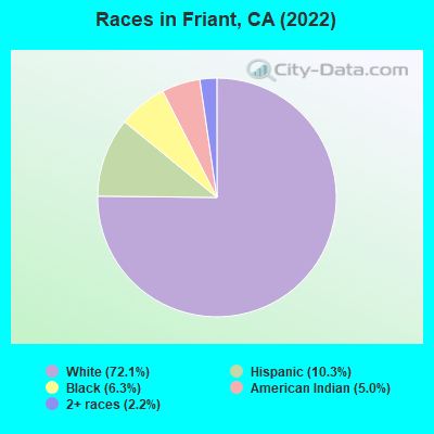
- 23072.1%White alone
- 3310.3%Hispanic
- 206.3%Black alone
- 165.0%American Indian alone
- 72.2%Two or more races
According to our research of California and other state lists, there were 4 registered sex offenders living in Friant, California as of April 26, 2024.
The ratio of all residents to sex offenders in Friant is 119 to 1.
 Recent articles from our blog. Our writers, many of them Ph.D. graduates or candidates, create easy-to-read articles on a wide variety of topics.

 | Friant Ranch and the growth in Fresno Metro area (16 replies) |
| San Joaquin Valley Gentrification thread(Fresno, Merced, Stockton, Bakersfield) (338 replies) |
| Massive 45,000-Home Development Nears Approval in Fresno (33 replies) |
| Long term ramifications on Bay Area Real Estate and Economy (228 replies) |
| Utterly underwhelmed (108 replies) |
| The nation’s hottest housing market? Surprise — it’s Fresno (76 replies) |
Latest news from Friant, CA collected exclusively by city-data.com from local newspapers, TV, and radio stations
Ancestries: German (17.5%), Russian (9.3%), French (8.2%).
Current Local Time: PST time zone
Elevation: 340 feet
Land area: 1.35 square miles.
Population density: 377 people per square mile (very low).
20 residents are foreign born (3.9% Asia).
| This place: | 3.9% |
| California: | 26.2% |
| Friant CDP: | 1.3% ($1,000) |
| California: | 0.8% ($1,564) |
Nearest city with pop. 50,000+: Clovis, CA  (11.4 miles , pop. 68,468).
Nearest city with pop. 200,000+: Fresno, CA (14.6 miles , pop. 427,652).
Nearest city with pop. 1,000,000+: Los Angeles, CA (214.2 miles , pop. 3,694,820).
Nearest cities:
), ), ), ), Latitude: 36.98 N, Longitude: 119.72 W
Area code: 559
Property values in Friant, CA
| Here: | 8.2% |
| California: | 5.1% |
Average climate in Friant, California
Based on data reported by over 4,000 weather stations


(lower is better)
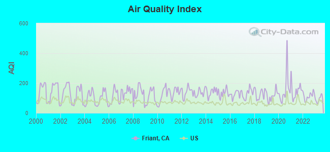
Air Quality Index (AQI) level in 2023 was 93.9. This is worse than average.
| City: | 93.9 |
| U.S.: | 72.6 |
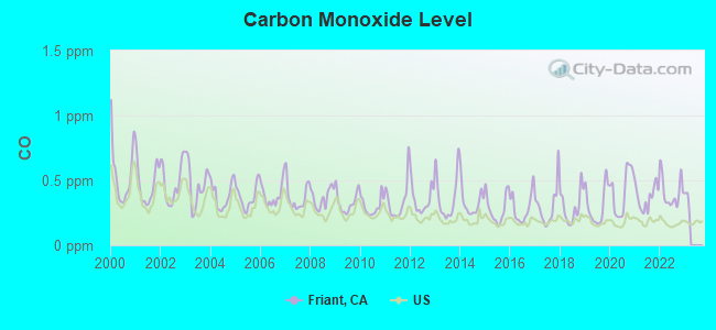
Carbon Monoxide (CO) [ppm] level in 2022 was 0.410. This is significantly worse than average. Closest monitor was 11.9 miles away from the city center.
| City: | 0.410 |
| U.S.: | 0.251 |

Nitrogen Dioxide (NO2) [ppb] level in 2022 was 8.32. This is significantly worse than average. Closest monitor was 11.4 miles away from the city center.
| City: | 8.32 |
| U.S.: | 5.11 |
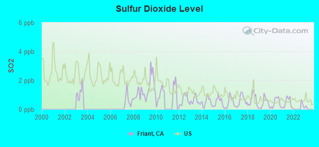
Sulfur Dioxide (SO2) [ppb] level in 2021 was 0.424. This is significantly better than average. Closest monitor was 12.9 miles away from the city center.
| City: | 0.424 |
| U.S.: | 1.515 |
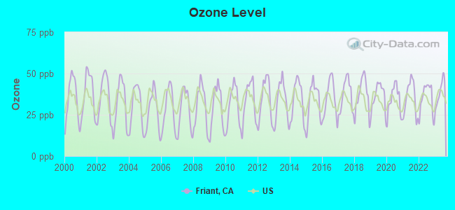
Ozone [ppb] level in 2023 was 38.7. This is about average. Closest monitor was 3.2 miles away from the city center.
| City: | 38.7 |
| U.S.: | 33.3 |
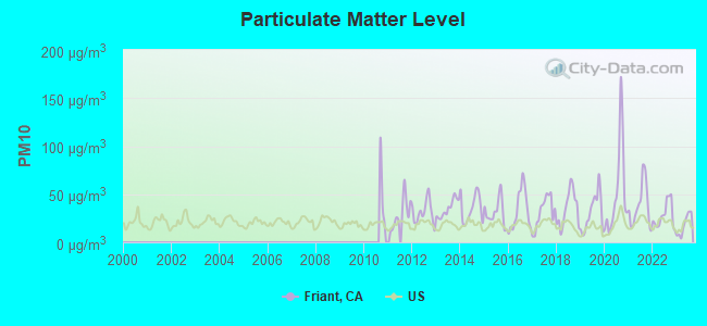
Particulate Matter (PM10) [µg/m3] level in 2023 was 18.3. This is about average. Closest monitor was 3.2 miles away from the city center.
| City: | 18.3 |
| U.S.: | 19.2 |
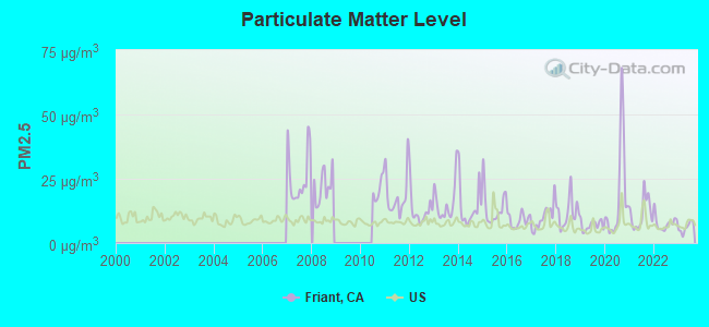
Particulate Matter (PM2.5) [µg/m3] level in 2023 was 6.01. This is better than average. Closest monitor was 3.2 miles away from the city center.
| City: | 6.01 |
| U.S.: | 8.11 |
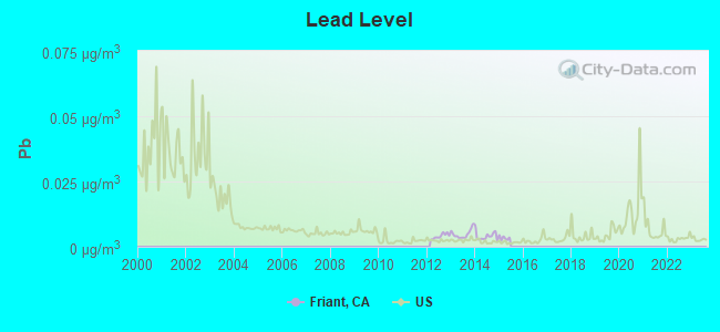
Lead (Pb) [µg/m3] level in 2014 was 0.00412. This is significantly better than average. Closest monitor was 14.1 miles away from the city center.
| City: | 0.00412 |
| U.S.: | 0.00931 |
Earthquake activity:
Friant-area historical earthquake activity is significantly above California state average. It is 8548% greater than the overall U.S. average.On 7/21/1952 at 11:52:14, a magnitude 7.7 (7.7 UK, Class: Major, Intensity: VIII - XII) earthquake occurred 143.0 miles away from Friant center, causing $50,000,000 total damage
On 4/18/1906 at 13:12:21, a magnitude 7.9 (7.9 UK) earthquake occurred 193.4 miles away from Friant center, causing $524,000,000 total damage
On 11/4/1927 at 13:51:53, a magnitude 7.5 (7.5 UK) earthquake occurred 160.9 miles away from Friant center
On 10/18/1989 at 00:04:15, a magnitude 7.1 (6.5 MB, 7.1 MS, 6.9 MW, 7.0 ML) earthquake occurred 113.7 miles away from Friant center, causing 62 deaths (62 shaking deaths) and 3757 injuries, causing $1,305,032,704 total damage
On 12/21/1932 at 06:10:09, a magnitude 7.2 (7.2 UK) earthquake occurred 138.2 miles away from the city center
On 6/28/1992 at 11:57:34, a magnitude 7.6 (6.2 MB, 7.6 MS, 7.3 MW, Depth: 0.7 mi) earthquake occurred 263.8 miles away from Friant center, causing 3 deaths (1 shaking deaths, 2 other deaths) and 400 injuries, causing $100,000,000 total damage and $40,000,000 insured losses
Magnitude types: body-wave magnitude (MB), local magnitude (ML), surface-wave magnitude (MS), moment magnitude (MW)
Natural disasters:
The number of natural disasters in Fresno County (12) is smaller than the US average (15).Major Disasters (Presidential) Declared: 8
Emergencies Declared: 2
Causes of natural disasters: Floods: 6, Storms: 4, Winter Storms: 3, Freezes: 2, Landslides: 2, Drought: 1, Fire: 1, Hurricane: 1, Other: 1 (Note: some incidents may be assigned to more than one category).

Hospitals and medical centers near Friant:
- FRESNO HEART AND SURGICAL HOSPITAL Acute Care Hospitals (about 10 miles away; FRESNO, CA)
- CPC-SIERRA GATEWAY HOSPITAL (Hospital, about 10 miles away; CLOVIS, CA)
- WILLOW CREEK HEALTHCARE CENTER (Nursing Home, about 10 miles away; CLOVIS, CA)
- KAISER FOUNDATION HOSPITAL - FRESNO Acute Care Hospitals (about 10 miles away; FRESNO, CA)
- HORIZON HEALTH AND SUBACUTE CENTER (Nursing Home, about 11 miles away; FRESNO, CA)
- SAN JOAQUIN VALLEY REHAB HOSP D/P SNF (Nursing Home, about 11 miles away; FRESNO, CA)
- GOOD SHEPHERD COMMUNITIES-DEWITT (Hospital, about 11 miles away; CLOVIS, CA)
Amtrak stations near Friant:
- 17 miles: MADERA (15 1/2 & 29TH RD.) . Services: partially wheelchair accessible, public payphones, free short-term parking, free long-term parking, call for taxi service.
- 18 miles: FRESNO (2650 TULARE ST.) . Services: ticket office, fully wheelchair accessible, enclosed waiting area, public restrooms, public payphones, vending machines, free short-term parking, free long-term parking, call for car rental service, call for taxi service, intercity bus service, public transit connection.
Colleges/universities with over 2000 students nearest to Friant:
- University of Phoenix-Central Valley Campus (about 10 miles; Fresno, CA; Full-time enrollment: 2,109)
- Institute of Technology Inc (about 11 miles; Clovis, CA; FT enrollment: 2,483)
- California State University-Fresno (about 12 miles; Fresno, CA; FT enrollment: 18,993)
- Heald College-Fresno (about 13 miles; Fresno, CA; FT enrollment: 2,199)
- Fresno City College (about 16 miles; Fresno, CA; FT enrollment: 12,994)
- Fresno Pacific University (about 18 miles; Fresno, CA; FT enrollment: 3,083)
- Reedley College (about 30 miles; Reedley, CA; FT enrollment: 8,144)
Points of interest:
Notable locations in Friant: Millerton Lake Fire Control Station (A), Fresno County Fire Protection District Millerton (B). Display/hide their locations on the map
Creek: Cottonwood Creek (A). Display/hide its location on the map
Drinking water stations with addresses in Friant and their reported violations in the past:
MILLERTON SRA MEADOW TANK HILL (Population served: 2,500, Surface water):Past monitoring violations:SUMNER PECK RANCH WINERY & FRUIT STAND (Population served: 100, Groundwater):
- Monthly Turbidity Exceed (Enhanced SWTR) - In MAR-2005, Contaminant: IESWTR. Follow-up actions: St Compliance achieved (APR-01-2005)
- 2 minor monitoring violations
- One regular monitoring violation
Past health violations:FRESNO RIFLE & PISTOL CLUB (Population served: 50, Groundwater):Past monitoring violations:
- MCL, Monthly (TCR) - In FEB-2013, Contaminant: Coliform. Follow-up actions: St AO (w/o penalty) issued (MAY-16-2013)
- 3 routine major monitoring violations
Past health violations:Past monitoring violations:
- MCL, Single Sample - Between JAN-2014 and MAR-2014, Contaminant: Nitrate. Follow-up actions: St AO (w/o penalty) issued (DEC-31-2013)
- MCL, Single Sample - Between OCT-2013 and DEC-2013, Contaminant: Nitrate. Follow-up actions: St AO (w/o penalty) issued (DEC-31-2013)
- Monitoring, Repeat Major (TCR) - In MAY-2010, Contaminant: Coliform (TCR). Follow-up actions: St Violation/Reminder Notice (AUG-26-2010)
- 2 routine major monitoring violations
- One minor monitoring violation
| This place: | 2.3 people |
| California: | 2.9 people |
| This place: | 62.9% |
| Whole state: | 68.7% |
| This place: | 7.6% |
| Whole state: | 7.2% |
Likely homosexual households (counted as self-reported same-sex unmarried-partner households)
- Lesbian couples: 0.4% of all households
- Gay men: 1.8% of all households
2 people in other workers' dormitories in 2000
For population 15 years and over in Friant:
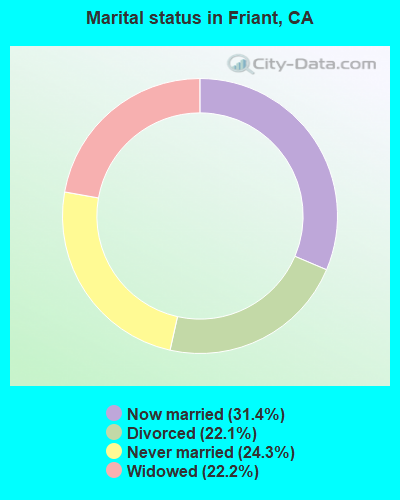
- Never married: 24.3%
- Now married: 31.4%
- Separated: 0.0%
- Widowed: 22.2%
- Divorced: 22.1%
For population 25 years and over in Friant:
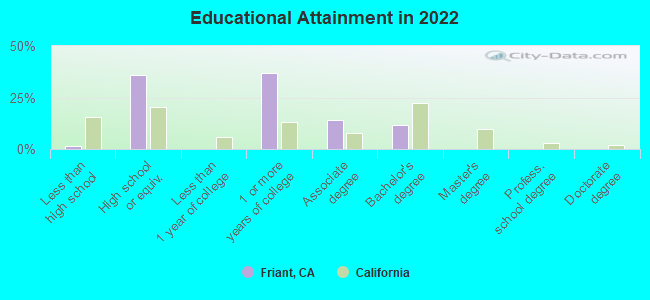
- High school or higher: 98.1%
- Bachelor's degree or higher: 11.1%
- Graduate or professional degree: 0.0%
- Unemployed: 18.9%
- Mean travel time to work (commute): 25.5 minutes
| Here: | 5.4 |
| California average: | 15.5 |
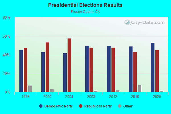
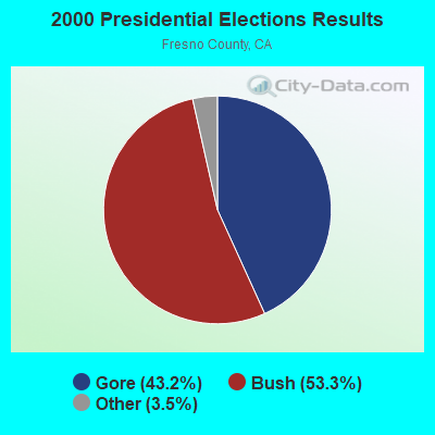
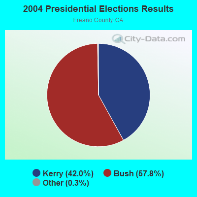
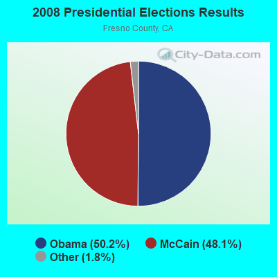
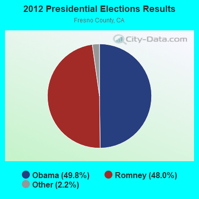
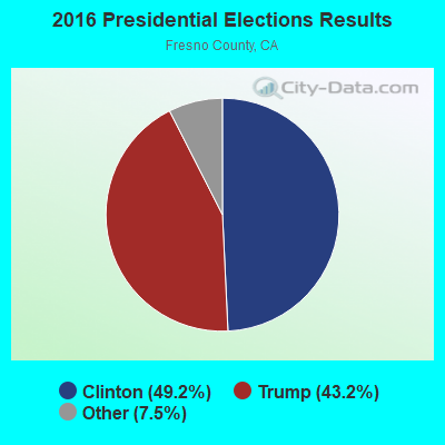
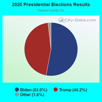
Graphs represent county-level data. Detailed 2008 Election Results
Religion statistics for Friant, CA (based on Fresno County data)
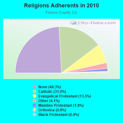
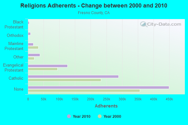
| Religion | Adherents | Congregations |
|---|---|---|
| Catholic | 288,324 | 43 |
| Evangelical Protestant | 126,004 | 463 |
| Other | 37,977 | 95 |
| Mainline Protestant | 16,843 | 70 |
| Orthodox | 7,768 | 9 |
| Black Protestant | 4,160 | 21 |
| None | 449,374 | - |
Food Environment Statistics:
| Fresno County: | 2.40 / 10,000 pop. |
| State: | 2.14 / 10,000 pop. |
| Fresno County: | 0.04 / 10,000 pop. |
| California: | 0.04 / 10,000 pop. |
| Fresno County: | 1.21 / 10,000 pop. |
| State: | 0.62 / 10,000 pop. |
| This county: | 2.12 / 10,000 pop. |
| California: | 1.49 / 10,000 pop. |
| Fresno County: | 5.77 / 10,000 pop. |
| State: | 7.42 / 10,000 pop. |
| Fresno County: | 7.6% |
| California: | 7.3% |
| Fresno County: | 26.4% |
| California: | 21.3% |
| Fresno County: | 17.5% |
| California: | 17.9% |
Health and Nutrition:
| This city: | 50.7% |
| California: | 49.4% |
| Friant: | 45.8% |
| State: | 48.0% |
| Friant: | 28.8 |
| California: | 28.1 |
| This city: | 21.2% |
| California: | 20.2% |
| This city: | 10.8% |
| California: | 11.2% |
| Here: | 6.9 |
| State: | 6.8 |
| Friant: | 36.5% |
| State: | 31.5% |
| This city: | 54.0% |
| State: | 56.4% |
| This city: | 74.0% |
| State: | 80.9% |
More about Health and Nutrition of Friant, CA Residents
3.57% of this county's 2021 resident taxpayers lived in other counties in 2020 ($51,894 average adjusted gross income)
| Here: | 3.57% |
| California average: | 5.19% |
0.01% of residents moved from foreign countries ($87 average AGI)
Fresno County: 0.01% California average: 0.03%
Top counties from which taxpayers relocated into this county between 2020 and 2021:
| from Madera County, CA | |
| from Tulare County, CA | |
| from Los Angeles County, CA |
3.88% of this county's 2020 resident taxpayers moved to other counties in 2021 ($61,665 average adjusted gross income)
| Here: | 3.88% |
| California average: | 6.14% |
0.01% of residents moved to foreign countries ($93 average AGI)
Fresno County: 0.01% California average: 0.02%
Top counties to which taxpayers relocated from this county between 2020 and 2021:
| to Madera County, CA | |
| to Tulare County, CA | |
| to Los Angeles County, CA |
Strongest AM radio stations in Friant:
- KOOR (790 AM; 10 kW; CLOVIS, CA; Owner: INFINITY RADIO OPERATIONS INC.)
- KMJ (580 AM; 50 kW; FRESNO, CA; Owner: INFINITY RADIO OPERATIONS INC.)
- KFIG (1430 AM; 5 kW; FRESNO, CA; Owner: BIG DAWG BROADCASTING, LLC)
- KWRU (940 AM; 50 kW; FRESNO, CA)
- KXEX (1550 AM; 10 kW; FRESNO, CA; Owner: RAK COMMUNICATIONS, INC.)
- KAVT (1680 AM; 10 kW; FRESNO, CA; Owner: RAK COMMUNICATIONS, INC.)
- KYNO (1300 AM; 5 kW; FRESNO, CA; Owner: SPANISH CATHOLIC RADIO OF FRESNO, LLC)
- KIRV (1510 AM; daytime; 10 kW; FRESNO, CA; Owner: GORE-OVERGAARD BROADCASTING, INC)
- KTNS (1060 AM; 5 kW; OAKHURST, CA; Owner: CALIFORNIA SIERRA CORPORATION)
- KCBC (770 AM; 50 kW; RIVERBANK, CA; Owner: KIERTRON, INC.)
- KGST (1600 AM; 5 kW; FRESNO, CA; Owner: LOTUS COMMUNICATIONS CORP.)
- KERI (1180 AM; 50 kW; WASCO-GREENACRES, CA; Owner: KWSO, INC.)
- KNBR (680 AM; 50 kW; SAN FRANCISCO, CA; Owner: KNBR LICO, INC.)
Strongest FM radio stations in Friant:
- KMGV (97.9 FM; FRESNO, CA; Owner: INFINITY RADIO OPERATIONS INC.)
- KMMM (107.1 FM; MADERA, CA; Owner: ILLINOIS LOTUS CORP)
- KFNO (90.3 FM; FRESNO, CA; Owner: FAMILY STATIONS, INC.)
- KLBN (105.1 FM; AUBERRY, CA; Owner: LOTUS COMMUNICATIONS CORP.)
- KOQO-FM (101.9 FM; FRESNO, CA; Owner: INFINITY RADIO OPERATIONS INC.)
- KRNC (105.9 FM; FRESNO, CA; Owner: INFINITY RADIO OPERATIONS INC.)
- KSKS (93.7 FM; FRESNO, CA; Owner: INFINITY RADIO OPERATIONS INC.)
- KFCF (88.1 FM; FRESNO, CA; Owner: FRESNO FREE COLLEGE FOUNDATION)
- KVPR (89.3 FM; FRESNO, CA; Owner: WHITE ASH BROADCASTING, INC.)
- KJFX (95.7 FM; FRESNO, CA; Owner: MESOSPHERE BROADCASTING LTD. PARTNERSHIP)
- K203CM (88.5 FM; SANGER, CA; Owner: EDUCATIONAL MEDIA FOUNDATION)
- KZOL (107.9 FM; NORTH FORK, CA; Owner: HBC LICENSE CORPORATION)
- KMAK (100.3 FM; ORANGE COVE, CA; Owner: RICHARD B. SMITH)
- KWYE (101.1 FM; FRESNO, CA; Owner: INFINITY RADIO OPERATIONS INC.)
- K276BW (103.1 FM; NORTH FORK BASS LAKE, CA; Owner: CALIFORNIA SIERRA CORPORATION)
- KDJK (103.9 FM; MARIPOSA, CA; Owner: CITADEL BROADCASTING COMPANY)
- KAMB (101.5 FM; MERCED, CA; Owner: CENTRAL VALLEY BROADCASTING CO. INC.)
- KEFR (89.9 FM; LE GRAND, CA; Owner: FAMILY STATIONS, INC.)
- KUBB (96.3 FM; MARIPOSA, CA; Owner: BUCKLEY BROADCASTING CORP. OF MONTEREY INC)
- KCIV (99.9 FM; MOUNT BULLION, CA; Owner: BOTT COMMUNICATIONS, INC.)
TV broadcast stations around Friant:
- K56DZ (Channel 56; FRESNO, CA; Owner: NATIONAL MINORITY T.V., INC.)
- K02OH (Channel 2; FRESNO, CA; Owner: W. R. PORTEE AND LORRAINE PORTEE)
- KHMM-CA (Channel 16; HANFORD, CA; Owner: CABALLERO TELEVISION TEXAS, L.L.C.)
- K05KM (Channel 5; FRESNO, CA; Owner: THREE ANGELS BROADCASTING NETWORK, INC.)
- KNSO (Channel 51; MERCED, CA; Owner: TELEMUNDO OF FRESNO, LLC)
- K12OZ (Channel 12; FRESNO, CA; Owner: THREE ANGELS BROADCASTING NETWORK)
- KVHF-LP (Channel 4; FRESNO, CA; Owner: GARY M. COCOLA FAMILY TRUST, GARY M. COCOLA TRUSTEE)
- KSEE (Channel 24; FRESNO, CA; Owner: KSEE LICENSE, INC.)
- KFRE-TV (Channel 59; SANGER, CA; Owner: SANGER TELECASTERS, INC.)
- KFSN-TV (Channel 30; FRESNO, CA; Owner: ABC, INC.)
- KGPE (Channel 47; FRESNO, CA; Owner: ACKERLEY BROADCASTING - FRESNO, LLC)
- KFTV (Channel 21; HANFORD, CA; Owner: KFTV LICENSE PARTNERSHIP, G.P.)
- KJEO-LP (Channel 32; FRESNO, CA; Owner: GARY M. COCOLA FAMILY TRUST, GARY M. COCOLA TRUSTEE)
- Friant, California
- Fatal accident count10
- Vehicles involved in fatal accidents15
- Fatal accidents involving drunk persons:1
- Fatalities11
- Persons involved in fatal accidents29
- Pedestrians involved in fatal accidents4
- California average
- Fatal accident count26166
- Vehicles involved in fatal accidents41008
- Fatal accidents involving drunk persons8709
- Fatalities28775
- Persons involved in fatal accidents67261
- Pedestrians involved in fatal accidents7845
- National Bridge Inventory (NBI) Statistics
- 3Number of bridges
- 33ft / 9.9mTotal length
- 9,420Total average daily traffic
- 483Total average daily truck traffic
- 11,248Total future (year 2040) average daily traffic
FCC Registered Cell Phone Towers:
1- Brighton Crest Development (Lat: 36.976944 Lon: -119.653278), Type: Pole, Structure height: 21.6 m, Overall height: 22.9 m, Call Sign: KNKA366
Assigned Frequencies: 869.040 MHz, 869.040 MHz, 824.040 MHz, 824.040 MHz, 890.010 MHz, 890.010 MHz, 845.010 MHz, 845.010 MHzGrant Date: 08/29/2017, Expiration Date: 10/01/2027, Certifier: Michael P GogginRegistrant: At&t Services, Inc., 208 S Akard St, 20f, Dallas, TX 75202, Phone: (855) 699-7073, Fax: (214) 746-6410, Email:
FCC Registered Broadcast Land Mobile Towers:
7- Millerton Lake Sra N Kiosk (Lat: 37.018556 Lon: -119.692917), Type: Building, Structure height: 3 m, Overall height: 4 m, Call Sign: KNEH776,
Assigned Frequencies: 812.937 MHz, 857.937 MHz, Grant Date: 05/04/2021, Expiration Date: 07/29/2031, Certifier: Glen S Nash, Registrant: State Of California, 601 Sequoia Pacific Blvd, Sacramento, CA 95811-0231, Phone: (916) 894-5102, Fax: (916) 894-5392, Email:
- MILLERTONFFSFRE, 4091 E Millerton Rd (Lat: 36.992528 Lon: -119.707194), Type: Tower, Structure height: 12.2 m, Overall height: 13.7 m, Call Sign: WPCB489,
Assigned Frequencies: 159.060 MHz, 159.195 MHz, Grant Date: 11/04/2023, Expiration Date: 01/31/2034, Registrant: State Of California, 601 Sequoia-Pacific Blvd., Sacramento, CA 95811-0231, Phone: (916) 894-5096, Fax: (916) 894-5392, Email:
- MILLERTONFFSFRE, 4091 E Millerton Rd (Lat: 36.992528 Lon: -119.707194), Type: Tower, Structure height: 12.2 m, Overall height: 13.7 m, Call Sign: KVY25,
Assigned Frequencies: 159.270 MHz, 159.300 MHz, 159.330 MHz, 159.360 MHz, Grant Date: 10/19/2023, Expiration Date: 01/06/2034, Registrant: State Of California, 601 Sequoia-Pacific Blvd., Sacramento, CA 95811-0231, Phone: (916) 894-5096, Fax: (916) 894-5392, Email:
- 8184 Table Mountain Rd (Lat: 36.983611 Lon: -119.640389), Type: Pole, Structure height: 39.9 m, Call Sign: WPUC639,
Assigned Frequencies: 462.825 MHz, Grant Date: 12/28/2021, Expiration Date: 02/04/2032, Certifier: Dave Floriano, Registrant: J\'s Communications, Inc., 3733 S. Bagley Ave., Suite C, Fresno, CA 93725, Phone: (559) 442-4400, Fax: (559) 442-4470, Email:
- Lat: 36.984333 Lon: -119.636944, Call Sign: WQGT478,
Assigned Frequencies: 451.237 MHz, 451.437 MHz, 452.512 MHz, 451.287 MHz, 451.387 MHz, 452.137 MHz, 451.412 MHz, 451.612 MHz, 452.162 MHz, 452.637 MHz, 462.187 MHz, Grant Date: 02/16/2017, Expiration Date: 04/12/2027, Certifier: Al Bianchi, Registrant: Washington Radio Reports, Gettysburg, PA 17325, Phone: (717) 334-0668, Fax: (717) 334-6440, Email:
- SANJOAQUINF&GFH, 17372 Brooktrout Drive (Lat: 36.987417 Lon: -119.715917), Type: Pipe, Structure height: 3.7 m, Overall height: 6.1 m, Call Sign: WQQD429,
Assigned Frequencies: 151.415 MHz, 151.422 MHz, 151.430 MHz, 159.420 MHz, 159.427 MHz, 159.435 MHz, Grant Date: 10/01/2022, Expiration Date: 11/06/2032, Certifier: John Lemmon, Registrant: State Of California, 601 Sequoia Pacific Blvd, Sacramento, CA 95811-0231, Phone: (916) 894-5102, Fax: (916) 894-5392, Email:
- Lat: 36.980500 Lon: -119.684861, Call Sign: WQRW942,
Assigned Frequencies: 461.512 MHz, 466.512 MHz, Grant Date: 07/29/2023, Expiration Date: 08/07/2033, Certifier: Cecil Miller, Registrant: Advanced Technical Services, 3179 W. Los Altos Ave., Fresno, CA 93711, Phone: (559) 647-6598, Fax: (559) 442-4470, Email:
FCC Registered Microwave Towers:
7- FAT-074, Masters Drive (Lat: 36.976917 Lon: -119.653250), Type: Tower, Structure height: 21.3 m, Call Sign: WQEB480,
Assigned Frequencies: 19585.0 MHz, Grant Date: 12/20/2005, Expiration Date: 12/20/2015, Cancellation Date: 10/21/2015, Certifier: Michael P Goggin, Registrant: At&t Mobility LLC, 1120 20th Street, Nw - Suite 1000, Washington, DC 20036, Phone: (202) 457-2055, Fax: (202) 457-3073, Email:
- FRIANT, 5920 Millerton Road (Lat: 36.994417 Lon: -119.697806), Type: Pole, Structure height: 45.7 m, Call Sign: WQOS373,
Assigned Frequencies: 6152.75 MHz, Grant Date: 01/13/2012, Expiration Date: 01/13/2022, Cancellation Date: 07/08/2013, Certifier: Pamelia Y Hoof, Registrant: Verizon Wireless, 1120 Sanctuary Pkwy, #150 Gasa5reg, Alpharetta, GA 30009-7630, Phone: (770) 797-1070, Fax: (770) 797-1036, Email:
- BRIGHTON CREST, 22120 Millerton Road (Lat: 36.976944 Lon: -119.653278), Type: Mtower, Structure height: 21.6 m, Overall height: 22.9 m, Call Sign: WQQZ397,
Assigned Frequencies: 10775.0 MHz, 10815.0 MHz, 11055.0 MHz, 11175.0 MHz, 19525.0 MHz, 19575.0 MHz, Grant Date: 02/28/2023, Expiration Date: 03/29/2033, Certifier: John Monday, Registrant: At&t Services, Inc., 208 S Akard St, 20f, Dallas, TX 75202, Phone: (855) 699-7073, Email:
- FRIANT & BELCHER, 5290 Millerton Road (Lat: 36.994167 Lon: -119.697833), Type: Mtower, Structure height: 45.7 m, Call Sign: WQSS214,
Assigned Frequencies: 17965.0 MHz, 18015.0 MHz, Grant Date: 10/03/2023, Expiration Date: 11/06/2033, Certifier: John Monday, Registrant: At&t Services, Inc., 208 S Akard St, 20f, Dallas, TX 75202, Phone: (855) 699-7073, Email:
- SC08587A, 5290 Millerton Rd (Lat: 36.994111 Lon: -119.697889), Type: Mtower, Structure height: 45.7 m, Call Sign: WRBS231,
Assigned Frequencies: 19540.0 MHz, 19540.0 MHz, 19540.0 MHz, 19540.0 MHz, 19540.0 MHz, 19540.0 MHz, 19540.0 MHz, 19540.0 MHz, 19540.0 MHz, 19620.0 MHz... (+38 more), Grant Date: 06/04/2018, Expiration Date: 06/04/2028, Certifier: David Werblow, Registrant: T-Mobile Usa, Inc., 12920 Se 38th Street, Bellevue, WA 98006, Phone: (425) 383-8401, Fax: (425) 383-4040, Email:
- Jolon Briggs, 4784 Millerton Road (Lat: 36.989167 Lon: -119.692000), Type: Building, Structure height: 7.6 m, Overall height: 13.7 m, Call Sign: WRVI466,
Assigned Frequencies: 10835.0 MHz, 10835.0 MHz, 10835.0 MHz, 10835.0 MHz, 10835.0 MHz, Grant Date: 11/28/2022, Expiration Date: 11/28/2032, Certifier: Peter L Sorensen, Registrant: Micronet Communications, Inc., 812 Lexington Dr, Plano, TX 75075, Phone: (972) 422-7200, Email:
- MERCER MTN, 53850 Road 210 (Lat: 37.127722 Lon: -119.678194), Type: Tower, Structure height: 30.5 m, Call Sign: KNL20,
Assigned Frequencies: 6123.10 MHz, 5945.20 MHz, 6093.45 MHz, Grant Date: 01/05/2021, Expiration Date: 02/01/2031, Registrant: Blooston, Mordkofsky, Dickens, Duffy & Prendergast, LLP, 2120 L Street, Nw, Suite300, Washington, DC 20037, Phone: (202) 828-5519, Fax: (202) 828-5568, Email:
FCC Registered Amateur Radio Licenses:
18 (See the full list of FCC Registered Amateur Radio Licenses in Friant)FAA Registered Aircraft Manufacturers and Dealers:
1- DOW FRED L, Po Box 254, Friant, CA 93626
Certificate: D000131 (Individual), Certificate Issue Date: 03/26/2008, Expiration Date: 03/25/2009
FAA Registered Aircraft:
4- Aircraft: ROBERT F CROOKS RV 10 (Category: Land, Seats: 4, Weight: Up to 12,499 Pounds), Engine: LYCOMING IO-540-C4B5 (250 HP) (Reciprocating)
N-Number: 412BC, N412BC, N-412BC, Serial Number: 41412, Year manufactured: 2017, Airworthiness Date: 03/14/2017, Certificate Issue Date: 04/14/2020
Registrant (Co-Owned): Robert F Trustee Crooks, 6082 Millerton Rd, Friant, CA 93626, Other Owners: Ellen Trustee Moy - Aircraft: MOONEY AIRCRAFT CORP. M20K (Category: Land, Seats: 4, Weight: Up to 12,499 Pounds), Engine: Reciprocating
N-Number: 5810G, N5810G, N-5810G, Serial Number: 25-0879, Year manufactured: 1985, Certificate Issue Date: 03/05/2001
Registrant (Individual): Fred L Dow, Po Box 254, Friant, CA 93626 - Aircraft: CESSNA TU206G (Category: Land, Seats: 6, Weight: Up to 12,499 Pounds, Speed: 132 mph), Engine: CONT MOTOR TSIO-520 SER (300 HP) (Reciprocating)
N-Number: 9610M, N9610M, N-9610M, Serial Number: U20604555, Year manufactured: 1978, Airworthiness Date: 08/05/1978, Certificate Issue Date: 09/05/1978
Registrant (Individual): Joseph S Butterweck, Po Box 261, Friant, CA 93626 - Aircraft: CESSNA 182Q (Category: Land, Seats: 4, Weight: Up to 12,499 Pounds, Speed: 112 mph), Engine: Reciprocating
N-Number: 97578, N97578, N-97578, Serial Number: 18267135, Year manufactured: 1979, Airworthiness Date: 07/20/1979, Certificate Issue Date: 10/29/2014
Registrant (Individual): Thomas A Utecht, 21956 Mary Rebecca Ln, Friant, CA 93626
| Home Mortgage Disclosure Act Aggregated Statistics For Year 2009 (Based on 1 partial tract) | ||
| C) Refinancings | ||
|---|---|---|
| Number | Average Value | |
| LOANS ORIGINATED | 2 | $265,810 |
| APPLICATIONS APPROVED, NOT ACCEPTED | 0 | $0 |
| APPLICATIONS DENIED | 1 | $446,080 |
| APPLICATIONS WITHDRAWN | 0 | $0 |
| FILES CLOSED FOR INCOMPLETENESS | 0 | $0 |
Detailed HMDA statistics for the following Tracts: 0055.15
| Private Mortgage Insurance Companies Aggregated Statistics For Year 1999 (Based on 1 partial tract) | ||||
| A) Conventional Home Purchase Loans | B) Refinancings | |||
|---|---|---|---|---|
| Number | Average Value | Number | Average Value | |
| LOANS ORIGINATED | 3 | $190,363 | 2 | $133,240 |
| APPLICATIONS APPROVED, NOT ACCEPTED | 0 | $0 | 0 | $0 |
| APPLICATIONS DENIED | 0 | $0 | 0 | $0 |
| APPLICATIONS WITHDRAWN | 0 | $0 | 0 | $0 |
| FILES CLOSED FOR INCOMPLETENESS | 0 | $0 | 0 | $0 |
Detailed PMIC statistics for the following Tracts: 0055.15
2004 - 2018 National Fire Incident Reporting System (NFIRS) incidents
- Fire incident types reported to NFIRS in Friant, CA
- 8858.7%Outside Fires
- 3322.0%Mobile Property/Vehicle Fires
- 2114.0%Structure Fires
- 85.3%Other
 According to the data from the years 2004 - 2018 the average number of fires per year is 10. The highest number of reported fire incidents - 17 took place in 2008, and the least - 1 in 2004. The data has a growing trend.
 When looking into fire subcategories, the most incidents belonged to: Outside Fires (58.7%), and Mobile Property/Vehicle Fires (22.0%).
| Most common first names in Friant, CA among deceased individuals | ||
| Name | Count | Lived (average) |
|---|---|---|
| William | 12 | 70.0 years |
| James | 7 | 77.9 years |
| John | 6 | 72.2 years |
| Robert | 6 | 75.7 years |
| Harold | 5 | 74.0 years |
| Ralph | 5 | 68.0 years |
| Dorothy | 5 | 72.8 years |
| Charles | 4 | 70.0 years |
| Virginia | 4 | 86.8 years |
| Joseph | 4 | 71.3 years |
| Most common last names in Friant, CA among deceased individuals | ||
| Last name | Count | Lived (average) |
|---|---|---|
| Jones | 6 | 66.8 years |
| Barnes | 5 | 70.6 years |
| Bonwell | 5 | 69.2 years |
| Lewis | 5 | 62.2 years |
| Brooks | 4 | 81.8 years |
| Lane | 3 | 72.3 years |
| Baker | 3 | 82.3 years |
| Burrough | 3 | 84.0 years |
| Simmons | 3 | 65.0 years |
| Phelps | 3 | 70.0 years |
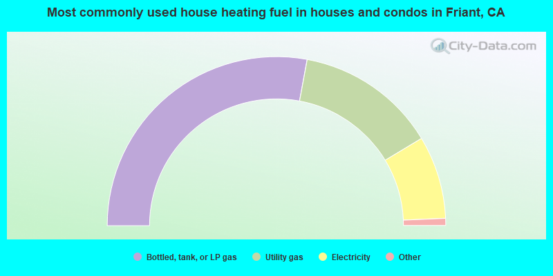
- 56.6%Bottled, tank, or LP gas
- 27.3%Utility gas
- 16.1%Electricity
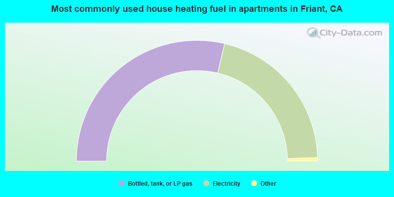
- 57.9%Bottled, tank, or LP gas
- 42.1%Electricity
Friant compared to California state average:
- Median household income below state average.
- Median house value significantly below state average.
- Hispanic race population percentage significantly below state average.
- Median age significantly above state average.
- Foreign-born population percentage significantly below state average.
- Renting percentage below state average.
- House age significantly below state average.
- Percentage of population with a bachelor's degree or higher significantly below state average.
Friant on our top lists:
- #72 on the list of "Top 101 cities with the most residents born in Pakistan (population 500+)"
- #5 on the list of "Top 101 counties with the highest Particulate Matter (PM2.5) Annual air pollution readings in 2012 (µg/m3)"
- #11 on the list of "Top 101 counties with the highest ground withdrawal of fresh water for public supply"
- #15 on the list of "Top 101 counties with the highest lead air pollution readings in 2012 (µg/m3)"
- #15 on the list of "Top 101 counties with the lowest lead air pollution readings in 2012 (µg/m3)"
- #15 on the list of "Top 101 counties with the highest Particulate Matter (PM10) Annual air pollution readings in 2012 (µg/m3)"