Bridge Statistics for Kansas City, Kansas (KS)
Condition, Traffic, Stress, Structural Evaluation, Project Costs
- National Bridge Inventory (NBI) Statistics
- 415Number of bridges
- 12,805ft / 3,903mTotal length
- $6,958,000Total costs
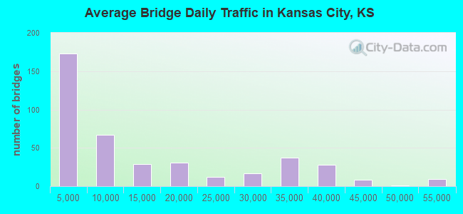
- 5,618,230Total average daily traffic
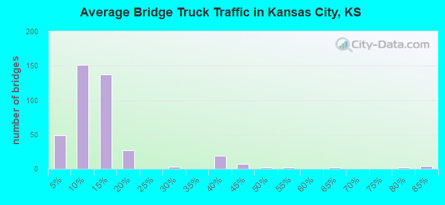
- 657,012Total average daily truck traffic
- National Bridge Inventory (NBI) Registered Bridges for Kansas City
- No street view available for this location
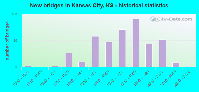
- New bridges - historical statistics
- 21900-1909
- 21920-1929
- 271930-1939
- 101940-1949
- 581950-1959
- 471960-1969
- 711970-1979
- 911980-1989
- 451990-1999
- 522000-2009
- 92010-2019
- 12020-2022
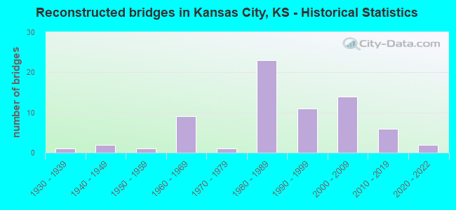
- Reconstructed bridges - Historical Statistics
- 11930-1939
- 21940-1949
- 11950-1959
- 91960-1969
- 11970-1979
- 231980-1989
- 111990-1999
- 142000-2009
- 62010-2019
- 22020-2022
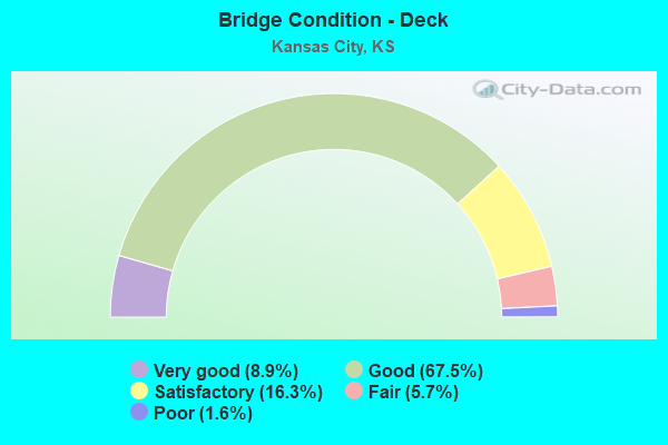
- Bridge Condition - Deck
- 8.9%Very good
- 67.5%Good
- 16.3%Satisfactory
- 5.7%Fair
- 1.6%Poor
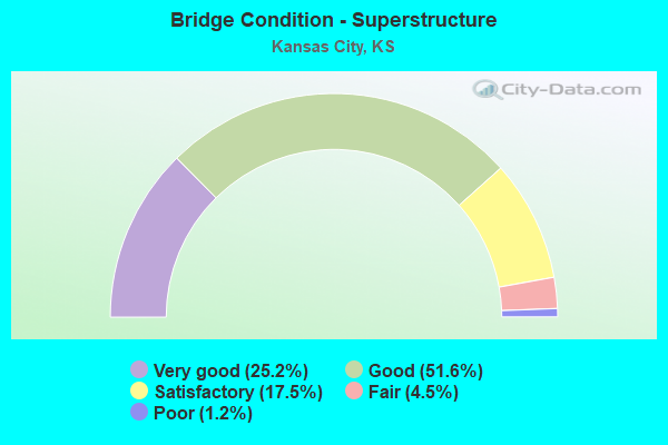
- Bridge Condition - Superstructure
- 25.2%Very good
- 51.6%Good
- 17.5%Satisfactory
- 4.5%Fair
- 1.2%Poor
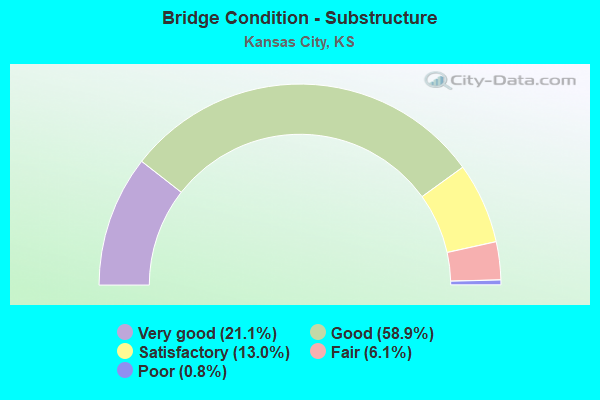
- Bridge Condition - Substructure
- 21.1%Very good
- 58.9%Good
- 13.0%Satisfactory
- 6.1%Fair
- 0.8%Poor
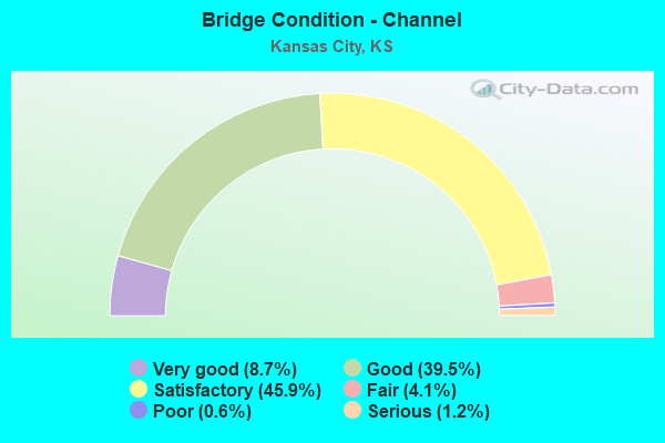
- Bridge Condition - Channel
- 8.7%Very good
- 39.5%Good
- 45.9%Satisfactory
- 4.1%Fair
- 0.6%Poor
- 1.2%Serious
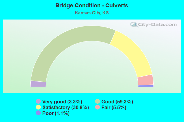
- Bridge Condition - Culverts
- 3.3%Very good
- 59.3%Good
- 30.8%Satisfactory
- 5.5%Fair
- 1.1%Poor
Find on map >> Show street view
Structure Number: 999963501051831, Location: I-635 / K-5 E INTERCHANGE (Lat: 39.146389, Lng: -94.657222), Route carried "under" structure: State highway 42, Year Built: 1974, Structure Length: 0. m, Average Daily Traffic: 3,485 (year 2020), Truck Traffic: 14%, Features Intersected: K-5 NB to K-5 NB, Facility Carried by Structure: I-635 NB HIGHWAY
Minimum Vertical Clearance: 5.02m (16.47ft), Kilometerpoint: 3.426, Lanes on structure: 2, Lanes under structure: 2, Material/Design: Steel continuous, Design/Construction: Stringer/Multi-beam, Length of Maximum Span: 49.7m (163.1ft)
Find on map >> Show street view
Structure Number: 999963501051841, Location: I-635 / K-5 E INTERCHANGE (Lat: 39.146111, Lng: -94.656944), Route carried "under" structure: State highway 5, Year Built: 1974, Structure Length: 0. m, Average Daily Traffic: 21,930 (year 2020), Truck Traffic: 14%, Features Intersected: I-635 NB & K-5 HIGHWAYS
Minimum Vertical Clearance: 5.25m (17.22ft), Kilometerpoint: 12.843, Lanes on structure: 1, Lanes under structure: 6, Material/Design: Steel continuous, Design/Construction: Stringer/Multi-beam, Length of Maximum Span: 32.0m (105.0ft)
Find on map >> Show street view
Structure Number: 999963501051841, Location: I-635 / K-5 E INTERCHANGE (Lat: 39.146111, Lng: -94.656944), Route carried "under" structure: State highway 5, Year Built: 1974, Structure Length: 0. m, Average Daily Traffic: 21,930 (year 2020), Truck Traffic: 14%, Features Intersected: I-635 NB & K-5 HIGHWAYS
Minimum Vertical Clearance: 5.69m (18.67ft), Kilometerpoint: 12.843, Lanes on structure: 1, Lanes under structure: 2, Material/Design: Steel continuous, Design/Construction: Stringer/Multi-beam, Length of Maximum Span: 32.0m (105.0ft)
Find on map >> Show street view
Structure Number: 999963501052991, Location: I-635 / I-70 INTERCHANGE (Lat: 39.103889, Lng: -94.677778), Route carried "under" structure: State highway 21, Year Built: 2004, Structure Length: 0. m, Average Daily Traffic: 32,872 (year 2020), Truck Traffic: 11%, Features Intersected: I-635 NB HIGHWAY, Facility Carried by Structure: I-635 SB TO I-70 E
Minimum Vertical Clearance: 5.48m (17.98ft), Kilometerpoint: 6.767, Lanes on structure: 1, Lanes under structure: 4, Material/Design: Steel continuous, Design/Construction: Stringer/Multi-beam, Length of Maximum Span: 44.0m (144.4ft)
Find on map >> Show street view
Structure Number: 999963501053021, Location: I-635 / I-70 INTERCHANGE (Lat: 39.105556, Lng: -94.680833), Route carried "under" structure: State highway 21, Year Built: 2004, Structure Length: 0. m, Average Daily Traffic: 32,872 (year 2020), Truck Traffic: 11%, Features Intersected: I-635 SB HIGHWAY, Facility Carried by Structure: I-635 NTO I-70 W
Minimum Vertical Clearance: 5.08m (16.67ft), Kilometerpoint: 6.888, Lanes on structure: 1, Lanes under structure: 4, Material/Design: Steel continuous, Design/Construction: Stringer/Multi-beam, Length of Maximum Span: 46.0m (150.9ft)
Find on map >> Show street view
Structure Number: 999963501053041, Location: .87 MI N US-24/I-635 JCT (Lat: 39.128333, Lng: -94.676667), Route carried "under" structure: Interstate 635, Year Built: 2004, Structure Length: 0. m, Average Daily Traffic: 25,905 (year 2020), Truck Traffic: 12%, Features Intersected: I-635 HWY, Facility Carried by Structure: PARALLEL, EB
Minimum Vertical Clearance: 5.27m (17.29ft), Kilometerpoint: 9.696, Lanes on structure: 3, Lanes under structure: 6, Material/Design: Steel continuous, Design/Construction: Stringer/Multi-beam, Length of Maximum Span: 23.3m (76.4ft)
Find on map >> Show street view
Structure Number: 999963501053101, Location: 2.36 MI N US-24/I-635 JCT (Lat: 39.144722, Lng: -94.668889), Route carried "under" structure: State highway 5, Year Built: 2004, Structure Length: 0. m, Average Daily Traffic: 24,736 (year 2020), Truck Traffic: 13%, Features Intersected: I-635 HWY, Facility Carried by Structure: 34TH ST
Minimum Vertical Clearance: 5.27m (17.29ft), Kilometerpoint: 11.743, Lanes on structure: 2, Lanes under structure: 8, Material/Design: Steel continuous, Design/Construction: Stringer/Multi-beam, Length of Maximum Span: 26.3m (86.3ft)
Find on map >> Show street view
Structure Number: 999963501053111, Location: .87 MI N US-24/I-635 JCT (Lat: 39.128333, Lng: -94.676667), Route carried "under" structure: Interstate 635, Year Built: 2005, Structure Length: 0. m, Average Daily Traffic: 25,905 (year 2020), Truck Traffic: 12%, Features Intersected: I-635 HWY, Facility Carried by Structure: PARALLEL, WB
Minimum Vertical Clearance: 6.08m (19.95ft), Kilometerpoint: 9.708, Lanes on structure: 2, Lanes under structure: 6, Material/Design: Steel continuous, Design/Construction: Stringer/Multi-beam, Length of Maximum Span: 23.3m (76.4ft)
Find on map >> Show street view
Structure Number: 999963501053261, Location: 1.43 MILES N I 35 (Lat: 39.058611, Lng: -94.679167), Route carried "under" structure: Interstate 635, Year Built: 2015, Structure Length: 0. m, Average Daily Traffic: 34,041 (year 2020), Truck Traffic: 9%, Features Intersected: I 635 HWY, Facility Carried by Structure: GIBBS ROAD
Minimum Vertical Clearance: 5.25m (17.22ft), Kilometerpoint: 1.685, Lanes on structure: 2, Lanes under structure: 7, Material/Design: Steel continuous, Design/Construction: Stringer/Multi-beam, Length of Maximum Span: 36.6m (120.1ft)
Find on map >> Show street view
Structure Number: 999967001052411, Location: 0.29 MI E MILL ST. (Lat: 39.094167, Lng: -94.626667), Route carried "under" structure: US 169, Year Built: 1990, Structure Length: 0. m, Average Daily Traffic: 12,526 (year 2020), Truck Traffic: 6%, Features Intersected: US69(7TH ST) 4 RAMPS, Facility Carried by Structure: I670 WB HIGHWAY
Minimum Vertical Clearance: 4.95m (16.24ft), Kilometerpoint: 9.001, Lanes on structure: 1, Lanes under structure: 1, Material/Design: Steel continuous, Design/Construction: Stringer/Multi-beam, Length of Maximum Span: 80.8m (265.1ft)
Find on map >> Show street view
Structure Number: 999967001052421, Location: 0.36 MI E MILL ST. (Lat: 39.094444, Lng: -94.625278), Route carried "under" structure: US 169, Year Built: 1990, Structure Length: 0. m, Average Daily Traffic: 12,526 (year 2020), Truck Traffic: 28%, Features Intersected: 169(7TH ST) & WB I-70 RP, Facility Carried by Structure: I670 EB HIGHWAY
Minimum Vertical Clearance: 6.65m (21.82ft), Kilometerpoint: 25.297, Lanes on structure: 3, Lanes under structure: 8, Material/Design: Steel continuous, Design/Construction: Stringer/Multi-beam, Length of Maximum Span: 50.9m (167.0ft)
Find on map >> Show street view
Structure Number: 999967001052421, Location: 0.36 MI E MILL ST. (Lat: 39.094444, Lng: -94.625278), Route carried "under" structure: US 169, Year Built: 1990, Structure Length: 0. m, Average Daily Traffic: 12,526 (year 2020), Truck Traffic: 28%, Features Intersected: 169(7TH ST) & WB I-70 RP, Facility Carried by Structure: I670 EB HIGHWAY
Minimum Vertical Clearance: 5.25m (17.22ft), Kilometerpoint: 25.297, Lanes on structure: 3, Lanes under structure: 2, Material/Design: Steel continuous, Design/Construction: Stringer/Multi-beam, Length of Maximum Span: 50.9m (167.0ft)
Find on map >> Show street view
Structure Number: 999967001052431, Location: 1.06 MI E MILL ST. (Lat: 39.098611, Lng: -94.612778), Route carried "under" structure: ServiceCity street 926, Year Built: 1990, Structure Length: 0. m, Average Daily Traffic: 9,819 (year 2020), Truck Traffic: 37%, Features Intersected: I70 HWY,3RPS,KS RV,RR'S, Facility Carried by Structure: I670 HWY EB
Minimum Vertical Clearance: 7.62m (25.00ft), Kilometerpoint: 25.861, Lanes on structure: 1, Lanes under structure: 1, Material/Design: Steel continuous, Design/Construction: Girder and Floorbeam System, Length of Maximum Span: 76.2m (250.0ft)
Find on map >> Show street view
Structure Number: 999967001052431, Location: 1.06 MI E MILL ST. (Lat: 39.098611, Lng: -94.612778), Route carried "under" structure: ServiceCity street 926, Year Built: 1990, Structure Length: 0. m, Average Daily Traffic: 9,819 (year 2020), Truck Traffic: 37%, Features Intersected: I70 HWY,3RPS,KS RV,RR'S, Facility Carried by Structure: I670 HWY EB
Minimum Vertical Clearance: 30.47m (99.97ft), Kilometerpoint: 25.861, Lanes on structure: 1, Lanes under structure: 1, Material/Design: Steel continuous, Design/Construction: Girder and Floorbeam System, Length of Maximum Span: 76.2m (250.0ft)
Find on map >> Show street view
Structure Number: 999967001052431, Location: 1.06 MI E MILL ST. (Lat: 39.098611, Lng: -94.612778), Route carried "under" structure: ServiceCity street 926, Year Built: 1990, Structure Length: 0. m, Average Daily Traffic: 9,819 (year 2020), Truck Traffic: 37%, Features Intersected: I70 HWY,3RPS,KS RV,RR'S, Facility Carried by Structure: I670 HWY EB
Minimum Vertical Clearance: 7.94m (26.05ft), Kilometerpoint: 25.861, Lanes on structure: 4, Lanes under structure: 4, Material/Design: Steel continuous, Design/Construction: Girder and Floorbeam System, Length of Maximum Span: 76.2m (250.0ft)
Find on map >> Show street view
Structure Number: 999967001052431, Location: 1.06 MI E MILL ST. (Lat: 39.098611, Lng: -94.612778), Route carried "under" structure: ServiceCity street 926, Year Built: 1990, Structure Length: 0. m, Average Daily Traffic: 9,819 (year 2020), Truck Traffic: 37%, Features Intersected: I70 HWY,3RPS,KS RV,RR'S, Facility Carried by Structure: I670 HWY EB
Minimum Vertical Clearance: 5.46m (17.91ft), Kilometerpoint: 25.861, Lanes on structure: 2, Lanes under structure: 2, Material/Design: Steel continuous, Design/Construction: Girder and Floorbeam System, Length of Maximum Span: 76.2m (250.0ft)
Find on map >> Show street view
Structure Number: 999967001052431, Location: 1.06 MI E MILL ST. (Lat: 39.098611, Lng: -94.612778), Route carried "under" structure: ServiceCity street 926, Year Built: 1990, Structure Length: 0. m, Average Daily Traffic: 9,819 (year 2020), Truck Traffic: 37%, Features Intersected: I70 HWY,3RPS,KS RV,RR'S, Facility Carried by Structure: I670 HWY EB
Minimum Vertical Clearance: 7.62m (25.00ft), Kilometerpoint: 25.861, Lanes on structure: 2, Lanes under structure: 2, Material/Design: Steel continuous, Design/Construction: Girder and Floorbeam System, Length of Maximum Span: 76.2m (250.0ft)
Find on map >> Show street view
Structure Number: 999967001052431, Location: 1.06 MI E MILL ST. (Lat: 39.098611, Lng: -94.612778), Route carried "under" structure: ServiceCity street 926, Year Built: 1990, Structure Length: 0. m, Average Daily Traffic: 9,819 (year 2020), Truck Traffic: 37%, Features Intersected: I70 HWY,3RPS,KS RV,RR'S, Facility Carried by Structure: I670 HWY EB
Minimum Vertical Clearance: 7.62m (25.00ft), Kilometerpoint: 25.861, Lanes on structure: 1, Lanes under structure: 1, Material/Design: Steel continuous, Design/Construction: Girder and Floorbeam System, Length of Maximum Span: 76.2m (250.0ft)
Find on map >> Show street view
Structure Number: 999967001052441, Location: 1.06 MI E MILL ST. (Lat: 39.098889, Lng: -94.612778), Route carried "under" structure: ServiceCity street 926, Year Built: 1990, Structure Length: 0. m, Average Daily Traffic: 9,819 (year 2020), Truck Traffic: 37%, Features Intersected: 70 HWY 3RPS,KS RV, RR'S, Facility Carried by Structure: I670 HWY WB
Minimum Vertical Clearance: 7.62m (25.00ft), Kilometerpoint: 25.947, Lanes on structure: 2, Lanes under structure: 2, Material/Design: Steel continuous, Design/Construction: Girder and Floorbeam System, Length of Maximum Span: 76.2m (250.0ft)
Find on map >> Show street view
Structure Number: 999967001052441, Location: 1.06 MI E MILL ST. (Lat: 39.098889, Lng: -94.612778), Route carried "under" structure: ServiceCity street 926, Year Built: 1990, Structure Length: 0. m, Average Daily Traffic: 9,819 (year 2020), Truck Traffic: 37%, Features Intersected: 70 HWY 3RPS,KS RV, RR'S, Facility Carried by Structure: I670 HWY WB
Minimum Vertical Clearance: 7.58m (24.87ft), Kilometerpoint: 25.947, Lanes on structure: 4, Lanes under structure: 5, Material/Design: Steel continuous, Design/Construction: Girder and Floorbeam System, Length of Maximum Span: 76.2m (250.0ft)
Find on map >> Show street view
Structure Number: 999967001052441, Location: 1.06 MI E MILL ST. (Lat: 39.098889, Lng: -94.612778), Route carried "under" structure: ServiceCity street 926, Year Built: 1990, Structure Length: 0. m, Average Daily Traffic: 9,819 (year 2020), Truck Traffic: 37%, Features Intersected: 70 HWY 3RPS,KS RV, RR'S, Facility Carried by Structure: I670 HWY WB
Minimum Vertical Clearance: 7.62m (25.00ft), Kilometerpoint: 25.947, Lanes on structure: 2, Lanes under structure: 2, Material/Design: Steel continuous, Design/Construction: Girder and Floorbeam System, Length of Maximum Span: 76.2m (250.0ft)
Find on map >> Show street view
Structure Number: 999967001052441, Location: 1.06 MI E MILL ST. (Lat: 39.098889, Lng: -94.612778), Route carried "under" structure: ServiceCity street 926, Year Built: 1990, Structure Length: 0. m, Average Daily Traffic: 9,819 (year 2020), Truck Traffic: 37%, Features Intersected: 70 HWY 3RPS,KS RV, RR'S, Facility Carried by Structure: I670 HWY WB
Minimum Vertical Clearance: 30.47m (99.97ft), Kilometerpoint: 25.947, Lanes on structure: 1, Lanes under structure: 1, Material/Design: Steel continuous, Design/Construction: Girder and Floorbeam System, Length of Maximum Span: 76.2m (250.0ft)
Find on map >> Show street view
Structure Number: 999967001052441, Location: 1.06 MI E MILL ST. (Lat: 39.098889, Lng: -94.612778), Route carried "under" structure: ServiceCity street 926, Year Built: 1990, Structure Length: 0. m, Average Daily Traffic: 9,819 (year 2020), Truck Traffic: 37%, Features Intersected: 70 HWY 3RPS,KS RV, RR'S, Facility Carried by Structure: I670 HWY WB
Minimum Vertical Clearance: 8.03m (26.35ft), Kilometerpoint: 25.947, Lanes on structure: 1, Lanes under structure: 1, Material/Design: Steel continuous, Design/Construction: Girder and Floorbeam System, Length of Maximum Span: 76.2m (250.0ft)
Find on map >> Show street view
Structure Number: 999967001052441, Location: 1.06 MI E MILL ST. (Lat: 39.098889, Lng: -94.612778), Route carried "under" structure: ServiceCity street 926, Year Built: 1990, Structure Length: 0. m, Average Daily Traffic: 9,819 (year 2020), Truck Traffic: 37%, Features Intersected: 70 HWY 3RPS,KS RV, RR'S, Facility Carried by Structure: I670 HWY WB
Minimum Vertical Clearance: 5.35m (17.55ft), Kilometerpoint: 25.947, Lanes on structure: 2, Lanes under structure: 2, Material/Design: Steel continuous, Design/Construction: Girder and Floorbeam System, Length of Maximum Span: 76.2m (250.0ft)