Bridge Statistics for Kansas City, Kansas (KS)
Condition, Traffic, Stress, Structural Evaluation, Project Costs
- National Bridge Inventory (NBI) Statistics
- 415Number of bridges
- 12,805ft / 3,903mTotal length
- $6,958,000Total costs
- 5,618,230Total average daily traffic
- 657,012Total average daily truck traffic
- National Bridge Inventory (NBI) Registered Bridges for Kansas City
- No street view available for this location
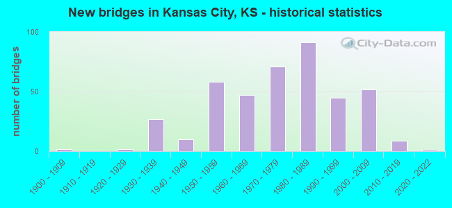
- New bridges - historical statistics
- 21900-1909
- 21920-1929
- 271930-1939
- 101940-1949
- 581950-1959
- 471960-1969
- 711970-1979
- 911980-1989
- 451990-1999
- 522000-2009
- 92010-2019
- 12020-2022
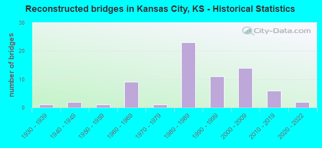
- Reconstructed bridges - Historical Statistics
- 11930-1939
- 21940-1949
- 11950-1959
- 91960-1969
- 11970-1979
- 231980-1989
- 111990-1999
- 142000-2009
- 62010-2019
- 22020-2022
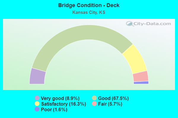
- Bridge Condition - Deck
- 8.9%Very good
- 67.5%Good
- 16.3%Satisfactory
- 5.7%Fair
- 1.6%Poor
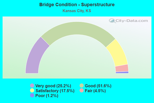
- Bridge Condition - Superstructure
- 25.2%Very good
- 51.6%Good
- 17.5%Satisfactory
- 4.5%Fair
- 1.2%Poor
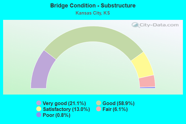
- Bridge Condition - Substructure
- 21.1%Very good
- 58.9%Good
- 13.0%Satisfactory
- 6.1%Fair
- 0.8%Poor
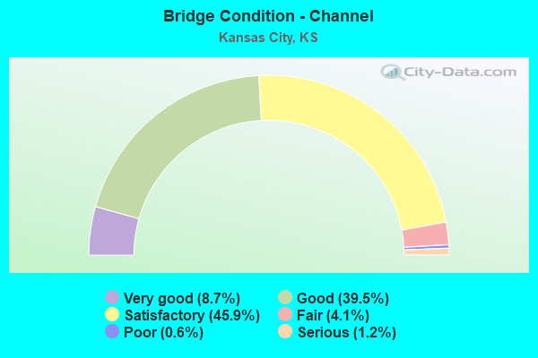
- Bridge Condition - Channel
- 8.7%Very good
- 39.5%Good
- 45.9%Satisfactory
- 4.1%Fair
- 0.6%Poor
- 1.2%Serious
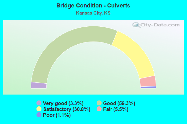
- Bridge Condition - Culverts
- 3.3%Very good
- 59.3%Good
- 30.8%Satisfactory
- 5.5%Fair
- 1.1%Poor
Find on map >> Show street view
Structure Number: 999943501052331, Location: 0.38 MI N/E K5 (Lat: 39.183056, Lng: -94.793889), Route carried "on" structure: Interstate 435, Year Built: 1985, Status: Open, Structure Length: 13.35m (43.80ft), Average Daily Traffic: 15,430 (year 2020), Truck Traffic: 10%, Average Future Daily Traffic: 27,868 (year 2041), Design Load: HS 20+Mod, Features Intersected: UP RAILROAD WOLCOTT
Minimum Vertical Clearance: 30.47m (99.97ft), Kilometerpoint: 16.927, Lanes on structure: 3, Lanes under structure: 4, Base Highway Network: Yes, Owner: State Highway Agency, Approaching Roadway Width: 19.5m (64.0ft), Material/Design: Steel continuous, Design/Construction: Stringer/Multi-beam, Number Of Spans In Main Unit: 5, Length of Maximum Span: 32.9m (107.9ft), Curb-To-Curb Width: 19.5m (64.0ft), Out-to-Out Width: 20.3m (66.6ft)
Condition: Deck: Good, Superstructure: Good, Substructure: Good, Operating Rating: 68.9 metric tons, Method Used To Determine Operating Rating: Load Factor (LF), Inventory Rating: 41.3 metric tons, Method Used To Determine Inventory Rating: Load Factor (LF), Structural Evaluation: Better than present minimum criteria, Deck Geometry: Superior to present desirable criteria, Underclear: Superior to present desirable criteria, Approach Roadway Alignment: Equal to present desirable criteria, Length Of Structure Improvement: 43.79m (143.67ft), Designated Inspection Frequency: Every 24 months, Inspection Date: June 2021, Wearing Surface/Protective System: Wearing Surface: Low Slump Concrete, Deck Protection: Epoxy Coated Reinforcing
Find on map >> Show street view
Structure Number: 999943501052341, Location: 0.37 MI N/E K5 (Lat: 39.183333, Lng: -94.794167), Route carried "on" structure: Interstate 435, Year Built: 1985, Status: Open, Structure Length: 13.35m (43.80ft), Average Daily Traffic: 15,430 (year 2020), Truck Traffic: 10%, Average Future Daily Traffic: 27,868 (year 2041), Design Load: HS 20+Mod, Features Intersected: UP RAILROAD
Minimum Vertical Clearance: 30.47m (99.97ft), Kilometerpoint: 16.954, Lanes on structure: 2, Lanes under structure: 4, Base Highway Network: Yes, Owner: State Highway Agency, Approaching Roadway Width: 15.2m (49.9ft), Material/Design: Steel continuous, Design/Construction: Stringer/Multi-beam, Number Of Spans In Main Unit: 5, Length of Maximum Span: 32.9m (107.9ft), Curb-To-Curb Width: 19.5m (64.0ft), Out-to-Out Width: 20.3m (66.6ft)
Condition: Deck: Good, Superstructure: Good, Substructure: Good, Operating Rating: 68.9 metric tons, Method Used To Determine Operating Rating: Load Factor (LF), Inventory Rating: 41.3 metric tons, Method Used To Determine Inventory Rating: Load Factor (LF), Structural Evaluation: Better than present minimum criteria, Deck Geometry: Superior to present desirable criteria, Underclear: Superior to present desirable criteria, Approach Roadway Alignment: Equal to present desirable criteria, Length Of Structure Improvement: 43.79m (143.67ft), Designated Inspection Frequency: Every 24 months, Inspection Date: June 2021, Wearing Surface/Protective System: Wearing Surface: Low Slump Concrete, Deck Protection: Epoxy Coated Reinforcing
Find on map >> Show street view
Structure Number: 999943501052511, Location: 0.48 MI N-JCT US24 (Lat: 39.123056, Lng: -94.813611), Route carried "on" structure: Interstate 435, Year Built: 1983, Status: Open, Structure Length: 5.27m (17.29ft), Average Daily Traffic: 25,390 (year 2020), Truck Traffic: 6%, Average Future Daily Traffic: 45,857 (year 2041), Design Load: HS 20+Mod, Features Intersected: France Family Dr.
Minimum Vertical Clearance: 30.47m (99.97ft), Kilometerpoint: 9.230, Lanes on structure: 4, Lanes under structure: 2, Base Highway Network: Yes, Owner: State Highway Agency, Approaching Roadway Width: 20.7m (67.9ft), Material/Design: Steel continuous, Design/Construction: Stringer/Multi-beam, Number Of Spans In Main Unit: 3, Length of Maximum Span: 24.4m (80.1ft), Curb-To-Curb Width: 20.7m (67.9ft), Out-to-Out Width: 21.3m (69.9ft)
Condition: Deck: Good, Superstructure: Good, Substructure: Very good, Operating Rating: 55.8 metric tons, Method Used To Determine Operating Rating: Load Factor (LF), Inventory Rating: 33.4 metric tons, Method Used To Determine Inventory Rating: Load Factor (LF), Structural Evaluation: Better than present minimum criteria, Deck Geometry: Equal to present minimum criteria, Underclear: Superior to present desirable criteria, Approach Roadway Alignment: Equal to present desirable criteria, Length Of Structure Improvement: 17.30m (56.76ft), Designated Inspection Frequency: Every 24 months, Inspection Date: September 2021, Deck Structure Type: Concrete Cast-file-Place, Wearing Surface/Protective System: Wearing Surface: Low Slump Concrete
Find on map >> Show street view
Structure Number: 999943501052521, Location: 0.48 MI N-JCT US24, SB (Lat: 39.123056, Lng: -94.813889), Route carried "on" structure: Interstate 435, Year Built: 1983, Status: Open, Structure Length: 5.27m (17.29ft), Average Daily Traffic: 25,390 (year 2020), Truck Traffic: 6%, Average Future Daily Traffic: 45,857 (year 2041), Design Load: HS 20+Mod, Features Intersected: France Family Dr.
Minimum Vertical Clearance: 30.47m (99.97ft), Kilometerpoint: 9.233, Lanes on structure: 4, Lanes under structure: 2, Base Highway Network: Yes, Owner: State Highway Agency, Approaching Roadway Width: 20.7m (67.9ft), Material/Design: Steel continuous, Design/Construction: Stringer/Multi-beam, Number Of Spans In Main Unit: 3, Length of Maximum Span: 24.4m (80.1ft), Curb-To-Curb Width: 20.7m (67.9ft), Out-to-Out Width: 21.3m (69.9ft)
Condition: Deck: Satisfactory, Superstructure: Good, Substructure: Good, Operating Rating: 55.8 metric tons, Method Used To Determine Operating Rating: Load Factor (LF), Inventory Rating: 33.4 metric tons, Method Used To Determine Inventory Rating: Load Factor (LF), Structural Evaluation: Better than present minimum criteria, Deck Geometry: Equal to present minimum criteria, Underclear: Superior to present desirable criteria, Approach Roadway Alignment: Equal to present desirable criteria, Length Of Structure Improvement: 17.30m (56.76ft), Designated Inspection Frequency: Every 24 months, Inspection Date: June 2021, Deck Structure Type: Concrete Cast-file-Place, Wearing Surface/Protective System: Wearing Surface: Low Slump Concrete
Find on map >> Show street view
Structure Number: 999943501052531, Location: 1.39 MI N. OF STATE AVE. (Lat: 39.135833, Lng: -94.818611), Route carried "on" structure: Interstate 435, Year Built: 1983, Status: Open, Structure Length: 5.70m (18.70ft), Average Daily Traffic: 19,171 (year 2020), Truck Traffic: 9%, Average Future Daily Traffic: 34,625 (year 2041), Design Load: HS 20+Mod, Features Intersected: GEORGIA AVENUE
Minimum Vertical Clearance: 30.47m (99.97ft), Kilometerpoint: 10.697, Lanes on structure: 4, Lanes under structure: 2, Base Highway Network: Yes, Owner: State Highway Agency, Approaching Roadway Width: 19.5m (64.0ft), Material/Design: Steel continuous, Design/Construction: Stringer/Multi-beam, Number Of Spans In Main Unit: 3, Length of Maximum Span: 24.4m (80.1ft), Curb-To-Curb Width: 20.7m (67.9ft), Out-to-Out Width: 21.5m (70.5ft)
Condition: Deck: Good, Superstructure: Good, Substructure: Very good, Operating Rating: 63.0 metric tons, Method Used To Determine Operating Rating: Load Factor (LF), Inventory Rating: 37.7 metric tons, Method Used To Determine Inventory Rating: Load Factor (LF), Structural Evaluation: Better than present minimum criteria, Deck Geometry: Equal to present minimum criteria, Underclear: Superior to present desirable criteria, Approach Roadway Alignment: Equal to present desirable criteria, Length Of Structure Improvement: 18.70m (61.35ft), Designated Inspection Frequency: Every 24 months, Inspection Date: June 2021, Deck Structure Type: Concrete Cast-file-Place, Wearing Surface/Protective System: Wearing Surface: Low Slump Concrete
Find on map >> Show street view
Structure Number: 999943501052541, Location: 1.38 MI N STATES AVE (Lat: 39.135556, Lng: -94.818889), Route carried "on" structure: Interstate 435, Year Built: 1983, Status: Open, Structure Length: 5.70m (18.70ft), Average Daily Traffic: 19,171 (year 2020), Truck Traffic: 9%, Average Future Daily Traffic: 34,625 (year 2041), Design Load: HS 20+Mod, Features Intersected: GEORGIA AVENUE
Minimum Vertical Clearance: 30.47m (99.97ft), Kilometerpoint: 10.705, Lanes on structure: 4, Lanes under structure: 2, Base Highway Network: Yes, Owner: State Highway Agency, Approaching Roadway Width: 19.5m (64.0ft), Material/Design: Steel continuous, Design/Construction: Stringer/Multi-beam, Number Of Spans In Main Unit: 3, Length of Maximum Span: 24.4m (80.1ft), Curb-To-Curb Width: 20.7m (67.9ft), Out-to-Out Width: 21.5m (70.5ft)
Condition: Deck: Satisfactory, Superstructure: Good, Substructure: Good, Operating Rating: 63.0 metric tons, Method Used To Determine Operating Rating: Load Factor (LF), Inventory Rating: 37.7 metric tons, Method Used To Determine Inventory Rating: Load Factor (LF), Structural Evaluation: Better than present minimum criteria, Deck Geometry: Equal to present minimum criteria, Underclear: Superior to present desirable criteria, Approach Roadway Alignment: Equal to present desirable criteria, Length Of Structure Improvement: 18.70m (61.35ft), Designated Inspection Frequency: Every 24 months, Inspection Date: June 2021, Deck Structure Type: Concrete Cast-file-Place, Wearing Surface/Protective System: Wearing Surface: Low Slump Concrete
Find on map >> Show street view
Structure Number: 999943501053231, Location: 2.99 MI N OF STATE AVE. (Lat: 39.158889, Lng: -94.818611), Route carried "on" structure: Ramp State highway 49, Year Built: 2007, Status: Open, Structure Length: 4.34m (14.24ft), Average Daily Traffic: 405 (year 2020), Truck Traffic: 5%, Average Future Daily Traffic: 30,794 (year 2041), Design Load: HL 93, Features Intersected: CONNOR CREEK, Facility Carried by Structure: DONAHUE-NB435 RMP
Minimum Vertical Clearance: 30.47m (99.97ft), Kilometerpoint: 0.055, Lanes on structure: 1, Owner: State Highway Agency, Approaching Roadway Width: 7.9m (25.9ft), Material/Design: Concrete continuous, Design/Construction: Slab, Number Of Spans In Main Unit: 3, Length of Maximum Span: 17.0m (55.8ft), Curb-To-Curb Width: 7.9m (25.9ft), Out-to-Out Width: 8.5m (27.9ft)
Condition: Deck: Very good, Superstructure: Very good, Substructure: Very good, Channel: Very good, Operating Rating: 55.4 metric tons, Method Used To Determine Operating Rating: Load and Resistance Factor Rating (LRFR) rating reported by rating factor(RF) method using HL-93 loadings, Inventory Rating: 42.8 metric tons, Method Used To Determine Inventory Rating: Load and Resistance Factor Rating (LRFR) rating reported by rating factor(RF) method using HL-93 loadings, Structural Evaluation: Equal to present desirable criteria, Deck Geometry: Equal to present desirable criteria, Waterway Adequacy: Equal to present desirable criteria, Approach Roadway Alignment: Somewhat better than minimum adequacy, Length Of Structure Improvement: 14.25m (46.75ft), Designated Inspection Frequency: Every 24 months, Inspection Date: June 2021, Wearing Surface/Protective System: Wearing Surface: Monolithic Concrete, Deck Protection: Epoxy Coated Reinforcing
Find on map >> Show street view
Structure Number: 999954001051781, Location: WB I70, US24 & MINN AVE (Lat: 39.114167, Lng: -94.616111), Route carried "on" structure: City street 2556, Year Built: 1962, Status: Open, Structure Length: 22.18m (72.77ft), Average Daily Traffic: 2,503 (year 2020), Truck Traffic: 7%, Average Future Daily Traffic: 2,047 (year 2041), Design Load: HS 20, Features Intersected: EB 24 & WB I70 & RR, Facility Carried by Structure: WB I70 TO WB MINN
Minimum Vertical Clearance: 30.47m (99.97ft), Kilometerpoint: 0.414, Lanes on structure: 2, Lanes under structure: 7, Owner: State Highway Agency, Approaching Roadway Width: 9.1m (29.9ft), Material/Design: Steel continuous, Design/Construction: Girder and Floorbeam System, Number Of Spans In Main Unit: 8, Length of Maximum Span: 38.1m (125.0ft), Curb-To-Curb Width: 9.1m (29.9ft), Out-to-Out Width: 10.0m (32.8ft)
Condition: Deck: Good, Superstructure: Satisfactory, Substructure: Good, Operating Rating: 35.4 metric tons, Method Used To Determine Operating Rating: Load Factor (LF), Inventory Rating: 20.9 metric tons, Method Used To Determine Inventory Rating: Load Factor (LF), Structural Evaluation: Somewhat better than minimum adequacy, Deck Geometry: Meets minimum limits, Underclear: Somewhat better than minimum adequacy, Approach Roadway Alignment: Better than present minimum criteria, Length Of Structure Improvement: 72.76m (238.71ft), Designated Inspection Frequency: Every 12 months, Critical Feature Inspection Frequency: Every 24 months, Inspection Date: June 2021, Critical Feature Inspection Date: June 2021, Deck Structure Type: Concrete Cast-file-Place, Wearing Surface/Protective System: Wearing Surface: Epoxy Overlay
Find on map >> Show street view
Structure Number: 999963500460721, Location: JCT MERRIAM DR/I635 (Lat: 39.042222, Lng: -94.675278), Route carried "on" structure: Interstate 635, Year Built: 1971, Year Reconstructed: 1990, Status: Open, Structure Length: 5.28m (17.32ft), Average Daily Traffic: 28,784 (year 2020), Truck Traffic: 9%, Average Future Daily Traffic: 35,122 (year 2041), Design Load: HS 20+Mod, Features Intersected: MERRIAM DRIVE
Minimum Vertical Clearance: 30.47m (99.97ft), Kilometerpoint: 0.546, Lanes on structure: 4, Lanes under structure: 4, Base Highway Network: Yes, Owner: State Highway Agency, Approaching Roadway Width: 18.3m (60.0ft), Skew: 1 degrees, Material/Design: Steel continuous, Design/Construction: Stringer/Multi-beam, Number Of Spans In Main Unit: 3, Length of Maximum Span: 20.7m (67.9ft), Curb-To-Curb Width: 18.3m (60.0ft), Out-to-Out Width: 19.1m (62.7ft)
Condition: Deck: Good, Superstructure: Good, Substructure: Good, Operating Rating: 63.5 metric tons, Method Used To Determine Operating Rating: Load Factor (LF), Inventory Rating: 38.1 metric tons, Method Used To Determine Inventory Rating: Load Factor (LF), Structural Evaluation: Better than present minimum criteria, Deck Geometry: Meets minimum limits, Underclear: Meets minimum limits, Approach Roadway Alignment: Better than present minimum criteria, Length Of Structure Improvement: 17.32m (56.82ft), Designated Inspection Frequency: Every 24 months, Inspection Date: May 2020, Deck Structure Type: Concrete Cast-file-Place, Wearing Surface/Protective System: Wearing Surface: Low Slump Concrete
Find on map >> Show street view
Structure Number: 999963501050321, Location: 1.02 MILES N I-35 (Lat: 39.053056, Lng: -94.679167), Route carried "on" structure: City street 2674, Year Built: 1971, Status: Open, Structure Length: 8.21m (26.94ft), Average Daily Traffic: 3,183 (year 2020), Truck Traffic: 7%, Average Future Daily Traffic: 2,603 (year 2041), Design Load: HS 20, Features Intersected: I-635 HIGHWAY, Facility Carried by Structure: SHWN DR
Minimum Vertical Clearance: 30.47m (99.97ft), Kilometerpoint: 1.638, Lanes on structure: 4, Lanes under structure: 6, Owner: State Highway Agency, Approaching Roadway Width: 16.5m (54.1ft), Skew: 1 degrees, Material/Design: Steel continuous, Design/Construction: Stringer/Multi-beam, Number Of Spans In Main Unit: 4, Length of Maximum Span: 27.7m (90.9ft), Curb or Sidewalk Widths: Left: 1.2m (3.9ft), Right: 1.2m (3.9ft), Curb-To-Curb Width: 17.7m (58.1ft), Out-to-Out Width: 21.4m (70.2ft)
Condition: Deck: Poor, Superstructure: Good, Substructure: Good, Operating Rating: 55.3 metric tons, Method Used To Determine Operating Rating: Load Factor (LF), Inventory Rating: 32.7 metric tons, Method Used To Determine Inventory Rating: Load Factor (LF), Structural Evaluation: Better than present minimum criteria, Deck Geometry: Somewhat better than minimum adequacy, Underclear: Better than present minimum criteria, Approach Roadway Alignment: Somewhat better than minimum adequacy, Length Of Structure Improvement: 26.95m (88.42ft), Designated Inspection Frequency: Every 24 months, Inspection Date: June 2021, Deck Structure Type: Concrete Cast-file-Place, Wearing Surface/Protective System: Wearing Surface: Epoxy Overlay
Find on map >> Show street view
Structure Number: 999963501050341, Location: 1.88 MILES N I-35 (Lat: 39.065833, Lng: -94.679444), Route carried "on" structure: Interstate 635, Year Built: 1971, Year Reconstructed: 2021, Status: Open, Structure Length: 4.95m (16.24ft), Average Daily Traffic: 34,041 (year 2020), Truck Traffic: 9%, Average Future Daily Traffic: 41,536 (year 2041), Design Load: HS 20+Mod, Features Intersected: DOUGLAS AVENUE
Minimum Vertical Clearance: 30.47m (99.97ft), Kilometerpoint: 2.464, Lanes on structure: 4, Lanes under structure: 2, Base Highway Network: Yes, Owner: State Highway Agency, Approaching Roadway Width: 21.2m (69.6ft), Material/Design: Concrete continuous, Design/Construction: Slab, Number Of Spans In Main Unit: 3, Length of Maximum Span: 19.5m (64.0ft), Curb-To-Curb Width: 20.8m (68.2ft), Out-to-Out Width: 21.6m (70.9ft)
Condition: Deck: Satisfactory, Superstructure: Satisfactory, Substructure: Good, Operating Rating: 68.9 metric tons, Method Used To Determine Operating Rating: Load Factor (LF), Inventory Rating: 41.7 metric tons, Method Used To Determine Inventory Rating: Load Factor (LF), Structural Evaluation: Equal to present minimum criteria, Deck Geometry: Equal to present minimum criteria, Underclear: Superior to present desirable criteria, Approach Roadway Alignment: Equal to present desirable criteria, Length Of Structure Improvement: 16.25m (53.31ft), Designated Inspection Frequency: Every 24 months, Inspection Date: June 2021, Deck Structure Type: Concrete Cast-file-Place, Wearing Surface/Protective System: Wearing Surface: Low Slump Concrete
Find on map >> Show street view
Structure Number: 999963501050351, Location: 1.87 MILES N I-35 (Lat: 39.065833, Lng: -94.679167), Route carried "on" structure: Interstate 635, Year Built: 1971, Year Reconstructed: 2020, Status: Open, Structure Length: 4.95m (16.24ft), Average Daily Traffic: 34,041 (year 2020), Truck Traffic: 9%, Average Future Daily Traffic: 41,536 (year 2041), Design Load: HS 20+Mod, Features Intersected: DOUGLAS AVENUE
Minimum Vertical Clearance: 30.47m (99.97ft), Kilometerpoint: 2.493, Lanes on structure: 3, Lanes under structure: 2, Base Highway Network: Yes, Owner: State Highway Agency, Approaching Roadway Width: 19.2m (63.0ft), Material/Design: Concrete continuous, Design/Construction: Slab, Number Of Spans In Main Unit: 3, Length of Maximum Span: 19.5m (64.0ft), Curb-To-Curb Width: 18.8m (61.7ft), Out-to-Out Width: 19.6m (64.3ft)
Condition: Deck: Satisfactory, Superstructure: Satisfactory, Substructure: Good, Operating Rating: 68.9 metric tons, Method Used To Determine Operating Rating: Load Factor (LF), Inventory Rating: 41.7 metric tons, Method Used To Determine Inventory Rating: Load Factor (LF), Structural Evaluation: Equal to present minimum criteria, Deck Geometry: Superior to present desirable criteria, Underclear: Superior to present desirable criteria, Approach Roadway Alignment: Equal to present desirable criteria, Length Of Structure Improvement: 16.25m (53.31ft), Designated Inspection Frequency: Every 24 months, Inspection Date: June 2021, Deck Structure Type: Concrete Cast-file-Place, Wearing Surface/Protective System: Wearing Surface: Bituminous
Find on map >> Show street view
Structure Number: 999963501050361, Location: 1.11 MI S OLD K132 (Lat: 39.073056, Lng: -94.680278), Route carried "on" structure: City street 2672, Year Built: 1971, Status: Open, Structure Length: 6.90m (22.64ft), Average Daily Traffic: 5,050 (year 2020), Truck Traffic: 7%, Average Future Daily Traffic: 4,130 (year 2041), Design Load: HS 20, Features Intersected: I-635 HIGHWAY, Facility Carried by Structure: METROPOLITAN AVE
Minimum Vertical Clearance: 30.47m (99.97ft), Kilometerpoint: 0.121, Lanes on structure: 5, Lanes under structure: 7, Owner: State Highway Agency, Approaching Roadway Width: 19.5m (64.0ft), Material/Design: Concrete continuous, Design/Construction: Box Beam or Girders - Multiple, Number Of Spans In Main Unit: 4, Length of Maximum Span: 21.9m (71.9ft), Curb or Sidewalk Widths: Left: 1.2m (3.9ft), Right: 1.2m (3.9ft), Curb-To-Curb Width: 20.7m (67.9ft), Out-to-Out Width: 24.4m (80.1ft)
Condition: Deck: Fair, Superstructure: Fair, Substructure: Satisfactory, Operating Rating: 64.4 metric tons, Method Used To Determine Operating Rating: Load Factor (LF), Inventory Rating: 38.6 metric tons, Method Used To Determine Inventory Rating: Load Factor (LF), Structural Evaluation: Somewhat better than minimum adequacy, Deck Geometry: Somewhat better than minimum adequacy, Underclear: Better than present minimum criteria, Approach Roadway Alignment: Somewhat better than minimum adequacy, Length Of Structure Improvement: 22.65m (74.31ft), Designated Inspection Frequency: Every 24 months, Inspection Date: June 2021, Deck Structure Type: Concrete Cast-file-Place, Wearing Surface/Protective System: Wearing Surface: Low Slump Concrete
Find on map >> Show street view
Structure Number: 999963501050371, Location: 0.97 MI S OLD K132 (Lat: 39.075278, Lng: -94.680278), Route carried "on" structure: ServiceCity street 1117, Year Built: 1971, Status: Open, Structure Length: 7.91m (25.95ft), Average Daily Traffic: 528 (year 2020), Truck Traffic: 1%, Average Future Daily Traffic: 43,866 (year 2041), Design Load: HS 20, Features Intersected: I-635 HIGHWAY, Facility Carried by Structure: STRONG AVE
Minimum Vertical Clearance: 30.47m (99.97ft), Kilometerpoint: 0.290, Lanes on structure: 2, Lanes under structure: 8, Owner: State Highway Agency, Approaching Roadway Width: 7.9m (25.9ft), Material/Design: Concrete continuous, Design/Construction: Box Beam or Girders - Multiple, Number Of Spans In Main Unit: 4, Length of Maximum Span: 25.9m (85.0ft), Curb or Sidewalk Widths: Left: 1.2m (3.9ft), Right: 1.2m (3.9ft), Curb-To-Curb Width: 9.1m (29.9ft), Out-to-Out Width: 12.9m (42.3ft)
Condition: Deck: Good, Superstructure: Good, Substructure: Good, Operating Rating: 73.7 metric tons, Method Used To Determine Operating Rating: Load Factor (LF), Inventory Rating: 44.1 metric tons, Method Used To Determine Inventory Rating: Load Factor (LF), Structural Evaluation: Better than present minimum criteria, Deck Geometry: Equal to present minimum criteria, Underclear: Somewhat better than minimum adequacy, Approach Roadway Alignment: Somewhat better than minimum adequacy, Length Of Structure Improvement: 25.95m (85.14ft), Designated Inspection Frequency: Every 24 months, Inspection Date: June 2021, Deck Structure Type: Concrete Cast-file-Place, Wearing Surface/Protective System: Wearing Surface: Low Slump Concrete
Find on map >> Show street view
Structure Number: 999963501050381, Location: 0.71 MI S OLD K132 (Lat: 39.079167, Lng: -94.680556), Route carried "on" structure: Interstate 635, Year Built: 1971, Year Reconstructed: 1997, Status: Open, Structure Length: 5.36m (17.59ft), Average Daily Traffic: 33,620 (year 2020), Truck Traffic: 9%, Average Future Daily Traffic: 41,023 (year 2041), Design Load: HS 20+Mod, Features Intersected: SWARTZ ROAD
Minimum Vertical Clearance: 30.47m (99.97ft), Kilometerpoint: 3.948, Lanes on structure: 3, Lanes under structure: 4, Base Highway Network: Yes, Owner: State Highway Agency, Approaching Roadway Width: 18.0m (59.1ft), Skew: 3 degrees, Material/Design: Steel continuous, Design/Construction: Stringer/Multi-beam, Number Of Spans In Main Unit: 3, Length of Maximum Span: 23.8m (78.1ft), Curb-To-Curb Width: 17.6m (57.7ft), Out-to-Out Width: 18.4m (60.4ft)
Condition: Deck: Good, Superstructure: Good, Substructure: Good, Operating Rating: 62.6 metric tons, Method Used To Determine Operating Rating: Load Factor (LF), Inventory Rating: 37.2 metric tons, Method Used To Determine Inventory Rating: Load Factor (LF), Structural Evaluation: Better than present minimum criteria, Deck Geometry: Better than present minimum criteria, Underclear: Equal to present minimum criteria, Approach Roadway Alignment: Equal to present desirable criteria, Length Of Structure Improvement: 17.57m (57.64ft), Designated Inspection Frequency: Every 24 months, Inspection Date: June 2021, Deck Structure Type: Concrete Cast-file-Place, Wearing Surface/Protective System: Wearing Surface: Low Slump Concrete
Find on map >> Show street view
Structure Number: 999963501050391, Location: 0.72 MI S OLD K132 (Lat: 39.079167, Lng: -94.680278), Route carried "on" structure: Interstate 635, Year Built: 1971, Year Reconstructed: 1997, Status: Open, Structure Length: 5.36m (17.59ft), Average Daily Traffic: 33,620 (year 2020), Truck Traffic: 9%, Average Future Daily Traffic: 41,023 (year 2041), Design Load: HS 20+Mod, Features Intersected: SWARTZ ROAD
Minimum Vertical Clearance: 30.47m (99.97ft), Kilometerpoint: 3.965, Lanes on structure: 3, Lanes under structure: 4, Base Highway Network: Yes, Owner: State Highway Agency, Approaching Roadway Width: 18.0m (59.1ft), Skew: 3 degrees, Material/Design: Steel continuous, Design/Construction: Stringer/Multi-beam, Number Of Spans In Main Unit: 3, Length of Maximum Span: 23.8m (78.1ft), Curb-To-Curb Width: 17.6m (57.7ft), Out-to-Out Width: 18.4m (60.4ft)
Condition: Deck: Good, Superstructure: Good, Substructure: Satisfactory, Operating Rating: 62.6 metric tons, Method Used To Determine Operating Rating: Load Factor (LF), Inventory Rating: 37.2 metric tons, Method Used To Determine Inventory Rating: Load Factor (LF), Structural Evaluation: Equal to present minimum criteria, Deck Geometry: Better than present minimum criteria, Underclear: Equal to present minimum criteria, Approach Roadway Alignment: Equal to present desirable criteria, Length Of Structure Improvement: 17.57m (57.64ft), Designated Inspection Frequency: Every 24 months, Inspection Date: June 2021, Deck Structure Type: Concrete Cast-file-Place, Wearing Surface/Protective System: Wearing Surface: Low Slump Concrete
Find on map >> Show street view
Structure Number: 999963501050401, Location: I-635/K-32 JCT (Lat: 39.085000, Lng: -94.680556), Route carried "on" structure: Interstate 635, Year Built: 1970, Year Reconstructed: 2021, Status: Open, Structure Length: 105.27m (345.37ft), Average Daily Traffic: 34,882 (year 2020), Truck Traffic: 8%, Average Future Daily Traffic: 43,413 (year 2041), Design Load: HS 20+Mod, Features Intersected: K-32 HWY, BNSF RR YARD
Minimum Vertical Clearance: 30.47m (99.97ft), Kilometerpoint: 4.603, Lanes on structure: 3, Lanes under structure: 6, Base Highway Network: Yes, Owner: State Highway Agency, Approaching Roadway Width: 17.7m (58.1ft), Skew: 20 degrees, Material/Design: Steel continuous, Design/Construction: Stringer/Multi-beam, Number Of Spans In Main Unit: 34, Number Of Approach Spans: 4, Length of Maximum Span: 40.5m (132.9ft), Curb-To-Curb Width: 15.8m (51.8ft), Out-to-Out Width: 16.3m (53.5ft)
Condition: Deck: Good, Superstructure: Satisfactory, Substructure: Good, Operating Rating: 44.5 metric tons, Method Used To Determine Operating Rating: Load Factor (LF), Inventory Rating: 27.2 metric tons, Method Used To Determine Inventory Rating: Load Factor (LF), Structural Evaluation: Equal to present minimum criteria, Deck Geometry: Somewhat better than minimum adequacy, Underclear: Equal to present minimum criteria, Approach Roadway Alignment: Equal to present desirable criteria, Length Of Structure Improvement: 345.37m (1133.10ft), Designated Inspection Frequency: Every 24 months, Inspection Date: June 2021, Deck Structure Type: Concrete Cast-file-Place, Wearing Surface/Protective System: Wearing Surface: Low Slump Concrete, Deck Protection: Epoxy Coated Reinforcing
Find on map >> Show street view
Structure Number: 999963501050411, Location: I-635/K-32 JCT (Lat: 39.085000, Lng: -94.680278), Route carried "on" structure: Interstate 635, Year Built: 1970, Year Reconstructed: 2005, Status: Open, Structure Length: 105.27m (345.37ft), Average Daily Traffic: 34,882 (year 2020), Truck Traffic: 8%, Average Future Daily Traffic: 42,563 (year 2041), Design Load: HS 20+Mod, Features Intersected: K-32 HWY, BNSF RR YARD
Minimum Vertical Clearance: 30.47m (99.97ft), Kilometerpoint: 4.624, Lanes on structure: 3, Lanes under structure: 6, Base Highway Network: Yes, Owner: State Highway Agency, Approaching Roadway Width: 15.8m (51.8ft), Material/Design: Steel continuous, Design/Construction: Stringer/Multi-beam, Number Of Spans In Main Unit: 34, Number Of Approach Spans: 4, Length of Maximum Span: 39.8m (130.6ft), Curb-To-Curb Width: 15.8m (51.8ft), Out-to-Out Width: 16.3m (53.5ft)
Condition: Deck: Good, Superstructure: Fair, Substructure: Satisfactory, Operating Rating: 45.2 metric tons, Method Used To Determine Operating Rating: Load Factor (LF), Inventory Rating: 27.0 metric tons, Method Used To Determine Inventory Rating: Load Factor (LF), Structural Evaluation: Somewhat better than minimum adequacy, Deck Geometry: Somewhat better than minimum adequacy, Underclear: Equal to present minimum criteria, Approach Roadway Alignment: Equal to present desirable criteria, Length Of Structure Improvement: 345.37m (1133.10ft), Designated Inspection Frequency: Every 24 months, Inspection Date: June 2021, Deck Structure Type: Concrete Cast-file-Place, Wearing Surface/Protective System: Wearing Surface: Low Slump Concrete, Deck Protection: Epoxy Coated Reinforcing
Find on map >> Show street view
Structure Number: 999963501050421, Location: 0.20 MI N OLD K-32 (Lat: 39.092222, Lng: -94.676944), Route carried "on" structure: Ramp State highway 38, Year Built: 1973, Year Reconstructed: 2021, Status: Open, Structure Length: 5.22m (17.13ft), Average Daily Traffic: 4,315 (year 2020), Truck Traffic: 5%, Average Future Daily Traffic: 46,423 (year 2041), Design Load: HS 20+Mod, Features Intersected: 42ND STREET, Facility Carried by Structure: I-635 NB to K-32
Minimum Vertical Clearance: 30.47m (99.97ft), Kilometerpoint: 0.401, Lanes on structure: 4, Lanes under structure: 2, Owner: State Highway Agency, Approaching Roadway Width: 18.3m (60.0ft), Skew: 20 degrees, Material/Design: Steel continuous, Design/Construction: Stringer/Multi-beam, Number Of Spans In Main Unit: 3, Length of Maximum Span: 19.5m (64.0ft), Curb-To-Curb Width: 21.1m (69.2ft), Out-to-Out Width: 24.9m (81.7ft)
Condition: Deck: Good, Superstructure: Good, Substructure: Good, Operating Rating: 59.0 metric tons, Method Used To Determine Operating Rating: Load Factor (LF), Inventory Rating: 35.4 metric tons, Method Used To Determine Inventory Rating: Load Factor (LF), Structural Evaluation: Better than present minimum criteria, Deck Geometry: Superior to present desirable criteria, Underclear: Superior to present desirable criteria, Approach Roadway Alignment: Somewhat better than minimum adequacy, Length Of Structure Improvement: 17.13m (56.20ft), Designated Inspection Frequency: Every 24 months, Inspection Date: June 2021, Wearing Surface/Protective System: Wearing Surface: Low Slump Concrete, Deck Protection: Epoxy Coated Reinforcing
Find on map >> Show street view
Structure Number: 999963501050431, Location: 0.39 MI N OLD K-32 (Lat: 39.095000, Lng: -94.680556), Route carried "on" structure: Interstate 635, Year Built: 1974, Year Reconstructed: 2021, Status: Open, Structure Length: 5.22m (17.13ft), Average Daily Traffic: 37,735 (year 2020), Truck Traffic: 9%, Average Future Daily Traffic: 46,964 (year 2041), Design Load: HS 20+Mod, Features Intersected: SPEAKER ROAD
Minimum Vertical Clearance: 30.47m (99.97ft), Kilometerpoint: 5.734, Lanes on structure: 7, Lanes under structure: 2, Base Highway Network: Yes, Owner: State Highway Agency, Approaching Roadway Width: 43.0m (141.1ft), Skew: 20 degrees, Material/Design: Steel continuous, Design/Construction: Stringer/Multi-beam, Number Of Spans In Main Unit: 3, Length of Maximum Span: 19.5m (64.0ft), Curb-To-Curb Width: 43.0m (141.1ft), Out-to-Out Width: 44.7m (146.7ft)
Condition: Deck: Good, Superstructure: Good, Substructure: Good, Operating Rating: 59.9 metric tons, Method Used To Determine Operating Rating: Load Factor (LF), Inventory Rating: 35.4 metric tons, Method Used To Determine Inventory Rating: Load Factor (LF), Structural Evaluation: Better than present minimum criteria, Deck Geometry: Superior to present desirable criteria, Underclear: Superior to present desirable criteria, Approach Roadway Alignment: Equal to present desirable criteria, Length Of Structure Improvement: 17.11m (56.14ft), Designated Inspection Frequency: Every 24 months, Inspection Date: June 2021, Wearing Surface/Protective System: Wearing Surface: Low Slump Concrete, Deck Protection: Epoxy Coated Reinforcing
Find on map >> Show street view
Structure Number: 999963501050441, Location: 0.28 MILES S I-70 (Lat: 39.099722, Lng: -94.679722), Route carried "on" structure: Interstate 635, Year Built: 1976, Year Reconstructed: 2006, Status: Open, Structure Length: 67.02m (219.88ft), Average Daily Traffic: 37,735 (year 2020), Truck Traffic: 9%, Average Future Daily Traffic: 46,964 (year 2041), Design Load: HS 20+Mod, Features Intersected: LEV RD, PL ENT, RIV, RR
Minimum Vertical Clearance: 30.47m (99.97ft), Kilometerpoint: 6.272, Lanes on structure: 4, Lanes under structure: 10, Base Highway Network: Yes, Owner: State Highway Agency, Approaching Roadway Width: 18.1m (59.4ft), Skew: 2 degrees, Material/Design: Steel continuous, Design/Construction: Stringer/Multi-beam, Number Of Spans In Main Unit: 8, Number Of Approach Spans: 7, Length of Maximum Span: 80.8m (265.1ft), Curb-To-Curb Width: 18.0m (59.1ft), Out-to-Out Width: 18.8m (61.7ft)
Condition: Deck: Good, Superstructure: Good, Substructure: Satisfactory, Channel: Good, Operating Rating: 67.6 metric tons, Method Used To Determine Operating Rating: Load Factor (LF), Inventory Rating: 40.8 metric tons, Method Used To Determine Inventory Rating: Load Factor (LF), Structural Evaluation: Equal to present minimum criteria, Deck Geometry: Meets minimum limits, Underclear: Better than present minimum criteria, Waterway Adequacy: Equal to present minimum criteria, Approach Roadway Alignment: Equal to present desirable criteria, Length Of Structure Improvement: 219.89m (721.42ft), Designated Inspection Frequency: Every 12 months, Critical Feature Inspection Frequency: Every 24 months, Underwater Inspection Frequency: Every 60 months, Inspection Date: August 2021, Critical Feature Inspection Date: August 2021, Underwater Inspection Date: September 2020, Wearing Surface/Protective System: Wearing Surface: Low Slump Concrete, Deck Protection: Epoxy Coated Reinforcing
Find on map >> Show street view
Structure Number: 999963501050451, Location: 0.27 MILES S I-70 (Lat: 39.099444, Lng: -94.679444), Route carried "on" structure: Interstate 635, Year Built: 1976, Year Reconstructed: 2005, Status: Open, Structure Length: 67.15m (220.31ft), Average Daily Traffic: 37,735 (year 2020), Truck Traffic: 9%, Average Future Daily Traffic: 46,964 (year 2041), Design Load: HS 20+Mod, Features Intersected: LEV RD, PL ENT, RIV, RR
Minimum Vertical Clearance: 30.47m (99.97ft), Kilometerpoint: 6.288, Lanes on structure: 3, Lanes under structure: 10, Base Highway Network: Yes, Owner: State Highway Agency, Approaching Roadway Width: 15.6m (51.2ft), Skew: 2 degrees, Material/Design: Steel continuous, Design/Construction: Stringer/Multi-beam, Number Of Spans In Main Unit: 5, Number Of Approach Spans: 10, Length of Maximum Span: 80.8m (265.1ft), Curb-To-Curb Width: 15.6m (51.2ft), Out-to-Out Width: 16.4m (53.8ft)
Condition: Deck: Good, Superstructure: Good, Substructure: Good, Channel: Satisfactory, Operating Rating: 68.0 metric tons, Method Used To Determine Operating Rating: Load Factor (LF), Inventory Rating: 40.7 metric tons, Method Used To Determine Inventory Rating: Load Factor (LF), Structural Evaluation: Better than present minimum criteria, Deck Geometry: Somewhat better than minimum adequacy, Underclear: Better than present minimum criteria, Waterway Adequacy: Equal to present minimum criteria, Approach Roadway Alignment: Equal to present desirable criteria, Length Of Structure Improvement: 220.29m (722.74ft), Designated Inspection Frequency: Every 24 months, Underwater Inspection Frequency: Every 60 months, Inspection Date: August 2021, Underwater Inspection Date: September 2020, Wearing Surface/Protective System: Wearing Surface: Low Slump Concrete, Deck Protection: Epoxy Coated Reinforcing
Find on map >> Show street view
Structure Number: 999963501050461, Location: 0.36 MILES N I-7O (Lat: 39.109444, Lng: -94.681389), Route carried "on" structure: City street 2645, Year Built: 1973, Year Reconstructed: 1998, Status: Open, Structure Length: 13.13m (43.08ft), Average Daily Traffic: 435 (year 2020), Truck Traffic: 5%, Average Future Daily Traffic: 356 (year 2041), Design Load: HS 20, Features Intersected: I-635 HIGHWAY, Facility Carried by Structure: ORVILLE AVE
Minimum Vertical Clearance: 30.47m (99.97ft), Kilometerpoint: 0.624, Lanes on structure: 4, Lanes under structure: 8, Owner: State Highway Agency, Approaching Roadway Width: 15.8m (51.8ft), Skew: 3 degrees, Material/Design: Steel continuous, Design/Construction: Stringer/Multi-beam, Number Of Spans In Main Unit: 4, Length of Maximum Span: 48.8m (160.1ft), Curb-To-Curb Width: 15.8m (51.8ft), Out-to-Out Width: 16.6m (54.5ft)
Condition: Deck: Good, Superstructure: Satisfactory, Substructure: Good, Operating Rating: 59.0 metric tons, Method Used To Determine Operating Rating: Load Factor (LF), Inventory Rating: 35.4 metric tons, Method Used To Determine Inventory Rating: Load Factor (LF), Structural Evaluation: Equal to present minimum criteria, Deck Geometry: Meets minimum limits, Underclear: Superior to present desirable criteria, Approach Roadway Alignment: Meets minimum limits, Length Of Structure Improvement: 43.09m (141.37ft), Designated Inspection Frequency: Every 24 months, Inspection Date: June 2021, Wearing Surface/Protective System: Wearing Surface: Monolithic Concrete, Deck Protection: Epoxy Coated Reinforcing
Find on map >> Show street view
Structure Number: 999963501050481, Location: I-635 (Lat: 39.116667, Lng: -94.681667), Route carried "on" structure: Interstate 635, Year Built: 1968, Year Reconstructed: 2013, Status: Open, Structure Length: 7.07m (23.20ft), Average Daily Traffic: 29,412 (year 2020), Truck Traffic: 11%, Average Future Daily Traffic: 35,184 (year 2041), Design Load: HS 20+Mod, Features Intersected: STATE AVE
Minimum Vertical Clearance: 30.47m (99.97ft), Kilometerpoint: 8.166, Lanes on structure: 4, Lanes under structure: 6, Base Highway Network: Yes, Owner: State Highway Agency, Approaching Roadway Width: 20.2m (66.3ft), Material/Design: Steel continuous, Design/Construction: Stringer/Multi-beam, Number Of Spans In Main Unit: 3, Length of Maximum Span: 28.0m (91.9ft), Curb-To-Curb Width: 20.2m (66.3ft), Out-to-Out Width: 20.9m (68.6ft)
Condition: Deck: Very good, Superstructure: Good, Substructure: Very good, Operating Rating: 72.6 metric tons, Method Used To Determine Operating Rating: Load Factor (LF), Inventory Rating: 43.5 metric tons, Method Used To Determine Inventory Rating: Load Factor (LF), Structural Evaluation: Better than present minimum criteria, Deck Geometry: Equal to present minimum criteria, Underclear: High priority of corrective action, Approach Roadway Alignment: Equal to present desirable criteria, Length Of Structure Improvement: 23.21m (76.15ft), Designated Inspection Frequency: Every 24 months, Inspection Date: June 2021, Deck Structure Type: Concrete Cast-file-Place, Wearing Surface/Protective System: Wearing Surface: Low Slump Concrete, Deck Protection: Other
Find on map >> Show street view
Structure Number: 999963501050491, Location: I-635 (Lat: 39.116667, Lng: -94.681389), Route carried "on" structure: Interstate 635, Year Built: 1968, Year Reconstructed: 2013, Status: Open, Structure Length: 7.07m (23.20ft), Average Daily Traffic: 29,412 (year 2020), Truck Traffic: 11%, Average Future Daily Traffic: 36,606 (year 2041), Design Load: HS 20+Mod, Features Intersected: STATE AVE
Minimum Vertical Clearance: 30.47m (99.97ft), Kilometerpoint: 8.301, Lanes on structure: 4, Lanes under structure: 6, Base Highway Network: Yes, Owner: State Highway Agency, Approaching Roadway Width: 20.2m (66.3ft), Material/Design: Steel continuous, Design/Construction: Stringer/Multi-beam, Number Of Spans In Main Unit: 3, Length of Maximum Span: 28.0m (91.9ft), Curb-To-Curb Width: 20.2m (66.3ft), Out-to-Out Width: 20.9m (68.6ft)
Condition: Deck: Very good, Superstructure: Good, Substructure: Very good, Operating Rating: 72.6 metric tons, Method Used To Determine Operating Rating: Load Factor (LF), Inventory Rating: 43.5 metric tons, Method Used To Determine Inventory Rating: Load Factor (LF), Structural Evaluation: Better than present minimum criteria, Deck Geometry: Equal to present minimum criteria, Underclear: Meets minimum limits, Approach Roadway Alignment: Equal to present desirable criteria, Length Of Structure Improvement: 23.21m (76.15ft), Designated Inspection Frequency: Every 24 months, Inspection Date: June 2021, Deck Structure Type: Concrete Cast-file-Place, Wearing Surface/Protective System: Wearing Surface: Low Slump Concrete, Deck Protection: Epoxy Coated Reinforcing
Find on map >> Show street view
Structure Number: 999963501050501, Location: 0.30 MILES N US-24 (Lat: 39.120556, Lng: -94.679167), Route carried "on" structure: Interstate 635, Year Built: 1968, Year Reconstructed: 2020, Status: Open, Structure Length: 3.61m (11.84ft), Average Daily Traffic: 29,412 (year 2020), Truck Traffic: 11%, Average Future Daily Traffic: 35,184 (year 2041), Design Load: HS 20+Mod, Features Intersected: 43RD STREET
Minimum Vertical Clearance: 30.47m (99.97ft), Kilometerpoint: 8.776, Lanes on structure: 7, Lanes under structure: 2, Base Highway Network: Yes, Owner: State Highway Agency, Approaching Roadway Width: 37.2m (122.0ft), Skew: 21 degrees, Material/Design: Concrete continuous, Design/Construction: Slab, Number Of Spans In Main Unit: 3, Length of Maximum Span: 14.0m (45.9ft), Curb-To-Curb Width: 37.3m (122.4ft), Out-to-Out Width: 38.8m (127.3ft)
Condition: Deck: Good, Superstructure: Good, Substructure: Good, Operating Rating: 55.9 metric tons, Method Used To Determine Operating Rating: Load Factor (LF), Inventory Rating: 33.5 metric tons, Method Used To Determine Inventory Rating: Load Factor (LF), Structural Evaluation: Better than present minimum criteria, Deck Geometry: Superior to present desirable criteria, Underclear: Meets minimum limits, Approach Roadway Alignment: Somewhat better than minimum adequacy, Length Of Structure Improvement: 11.85m (38.88ft), Designated Inspection Frequency: Every 24 months, Inspection Date: June 2021, Deck Structure Type: Concrete Cast-file-Place, Wearing Surface/Protective System: Wearing Surface: Low Slump Concrete
Find on map >> Show street view
Structure Number: 999963501050551, Location: 1.38 MILES N US-24 (Lat: 39.135556, Lng: -94.675833), Route carried "on" structure: City street 2648, Year Built: 1968, Status: Open, Structure Length: 6.17m (20.24ft), Average Daily Traffic: 2,552 (year 2020), Truck Traffic: 5%, Average Future Daily Traffic: 3,304 (year 2041), Design Load: HS 20, Features Intersected: I-635 HIGHWAY, Facility Carried by Structure: GEORGIA AVE
Minimum Vertical Clearance: 30.47m (99.97ft), Kilometerpoint: 1.851, Lanes on structure: 2, Lanes under structure: 6, Owner: State Highway Agency, Approaching Roadway Width: 9.8m (32.2ft), Material/Design: Concrete continuous, Design/Construction: Box Beam or Girders - Multiple, Number Of Spans In Main Unit: 4, Length of Maximum Span: 17.7m (58.1ft), Curb or Sidewalk Widths: Left: 1.2m (3.9ft), Right: 1.2m (3.9ft), Curb-To-Curb Width: 9.8m (32.2ft), Out-to-Out Width: 12.9m (42.3ft)
Condition: Deck: Good, Superstructure: Good, Substructure: Good, Operating Rating: 74.6 metric tons, Method Used To Determine Operating Rating: Load Factor (LF), Inventory Rating: 44.6 metric tons, Method Used To Determine Inventory Rating: Load Factor (LF), Structural Evaluation: Better than present minimum criteria, Deck Geometry: Meets minimum limits, Underclear: Superior to present desirable criteria, Approach Roadway Alignment: Meets minimum limits, Length Of Structure Improvement: 20.25m (66.44ft), Designated Inspection Frequency: Every 24 months, Inspection Date: June 2021, Deck Structure Type: Concrete Cast-file-Place, Wearing Surface/Protective System: Wearing Surface: Low Slump Concrete
Find on map >> Show street view
Structure Number: 999963501050561, Location: 1.79 MILES N US-24 (Lat: 39.140833, Lng: -94.673056), Route carried "on" structure: Interstate 635, Year Built: 1970, Status: Open, Structure Length: 6.81m (22.34ft), Average Daily Traffic: 24,736 (year 2020), Truck Traffic: 13%, Average Future Daily Traffic: 29,591 (year 2041), Design Load: HS 20+Mod, Features Intersected: 38TH STREET
Minimum Vertical Clearance: 30.47m (99.97ft), Kilometerpoint: 11.053, Lanes on structure: 3, Lanes under structure: 4, Base Highway Network: Yes, Owner: State Highway Agency, Approaching Roadway Width: 15.8m (51.8ft), Skew: 4 degrees, Material/Design: Concrete continuous, Design/Construction: Box Beam or Girders - Multiple, Number Of Spans In Main Unit: 3, Length of Maximum Span: 27.4m (89.9ft), Curb-To-Curb Width: 16.3m (53.5ft), Out-to-Out Width: 16.9m (55.4ft)
Condition: Deck: Good, Superstructure: Good, Substructure: Very good, Operating Rating: 63.4 metric tons, Method Used To Determine Operating Rating: Load Factor (LF), Inventory Rating: 37.9 metric tons, Method Used To Determine Inventory Rating: Load Factor (LF), Structural Evaluation: Better than present minimum criteria, Deck Geometry: Equal to present minimum criteria, Underclear: Meets minimum limits, Approach Roadway Alignment: Better than present minimum criteria, Length Of Structure Improvement: 22.34m (73.29ft), Designated Inspection Frequency: Every 24 months, Inspection Date: June 2021, Deck Structure Type: Concrete Cast-file-Place, Wearing Surface/Protective System: Wearing Surface: Low Slump Concrete
Find on map >> Show street view
Structure Number: 999963501050571, Location: 1.80 MILES N US-24 (Lat: 39.140833, Lng: -94.673056), Route carried "on" structure: Interstate 635, Year Built: 1970, Status: Open, Structure Length: 6.81m (22.34ft), Average Daily Traffic: 24,736 (year 2020), Truck Traffic: 13%, Average Future Daily Traffic: 29,591 (year 2041), Design Load: HS 20+Mod, Features Intersected: 38TH STREET
Minimum Vertical Clearance: 30.47m (99.97ft), Kilometerpoint: 11.156, Lanes on structure: 3, Lanes under structure: 4, Base Highway Network: Yes, Owner: State Highway Agency, Approaching Roadway Width: 15.8m (51.8ft), Skew: 4 degrees, Material/Design: Concrete continuous, Design/Construction: Box Beam or Girders - Multiple, Number Of Spans In Main Unit: 3, Length of Maximum Span: 27.4m (89.9ft), Curb-To-Curb Width: 16.3m (53.5ft), Out-to-Out Width: 16.9m (55.4ft)
Condition: Deck: Satisfactory, Superstructure: Good, Substructure: Very good, Operating Rating: 63.4 metric tons, Method Used To Determine Operating Rating: Load Factor (LF), Inventory Rating: 37.9 metric tons, Method Used To Determine Inventory Rating: Load Factor (LF), Structural Evaluation: Better than present minimum criteria, Deck Geometry: Equal to present minimum criteria, Underclear: Meets minimum limits, Approach Roadway Alignment: Somewhat better than minimum adequacy, Length Of Structure Improvement: 22.34m (73.29ft), Designated Inspection Frequency: Every 24 months, Inspection Date: June 2021, Deck Structure Type: Concrete Cast-file-Place, Wearing Surface/Protective System: Wearing Surface: Low Slump Concrete
Find on map >> Show street view
Structure Number: 999963501051521, Location: I-70 / I-635 INTERCHANGE (Lat: 39.104167, Lng: -94.677778), Route carried "on" structure: Ramp State highway 21, Year Built: 1974, Status: Open, Structure Length: 45.28m (148.56ft), Average Daily Traffic: 9,715 (year 2020), Truck Traffic: 5%, Average Future Daily Traffic: 53,761 (year 2041), Design Load: HS 20+Mod, Features Intersected: I-635 NB,& I-70 HIGHWAYS, Facility Carried by Structure: I70 WB TO I635 SB
Minimum Vertical Clearance: 30.47m (99.97ft), Kilometerpoint: 0.360, Lanes on structure: 1, Lanes under structure: 15, Owner: State Highway Agency, Approaching Roadway Width: 9.1m (29.9ft), Material/Design: Steel continuous, Design/Construction: Stringer/Multi-beam, Number Of Spans In Main Unit: 14, Length of Maximum Span: 50.9m (167.0ft), Curb-To-Curb Width: 8.8m (28.9ft), Out-to-Out Width: 9.7m (31.8ft)
Condition: Deck: Poor, Superstructure: Satisfactory, Substructure: Good, Operating Rating: 65.3 metric tons, Method Used To Determine Operating Rating: Load Factor (LF), Inventory Rating: 39.0 metric tons, Method Used To Determine Inventory Rating: Load Factor (LF), Structural Evaluation: Equal to present minimum criteria, Deck Geometry: Superior to present desirable criteria, Underclear: Meets minimum limits, Approach Roadway Alignment: Somewhat better than minimum adequacy, Length Of Structure Improvement: 148.56m (487.40ft), Designated Inspection Frequency: Every 24 months, Inspection Date: June 2021, Deck Structure Type: Concrete Cast-file-Place, Wearing Surface/Protective System: Wearing Surface: Epoxy Overlay
Find on map >> Show street view
Structure Number: 999963501051571, Location: I-70 / I-635 INTERCHANGE (Lat: 39.105556, Lng: -94.680278), Route carried "on" structure: Ramp State highway 21, Year Built: 1975, Year Reconstructed: 2019, Status: Open, Structure Length: 13.72m (45.01ft), Average Daily Traffic: 8,520 (year 2020), Truck Traffic: 5%, Average Future Daily Traffic: 53,761 (year 2041), Design Load: HS 20+Mod, Features Intersected: I-70 WB, I-635 SB, 2 RPS, Facility Carried by Structure: I70 EB TO I635 NB
Minimum Vertical Clearance: 30.47m (99.97ft), Kilometerpoint: 0.340, Lanes on structure: 1, Lanes under structure: 5, Owner: State Highway Agency, Approaching Roadway Width: 9.1m (29.9ft), Material/Design: Steel continuous, Design/Construction: Stringer/Multi-beam, Number Of Spans In Main Unit: 4, Length of Maximum Span: 40.7m (133.5ft), Curb-To-Curb Width: 9.2m (30.2ft), Out-to-Out Width: 10.0m (32.8ft)
Condition: Deck: Very good, Superstructure: Very good, Substructure: Very good, Operating Rating: 87.1 metric tons, Method Used To Determine Operating Rating: Load Factor (LF), Inventory Rating: 51.7 metric tons, Method Used To Determine Inventory Rating: Load Factor (LF), Structural Evaluation: Equal to present desirable criteria, Deck Geometry: Superior to present desirable criteria, Underclear: Equal to present desirable criteria, Approach Roadway Alignment: Somewhat better than minimum adequacy, Length Of Structure Improvement: 45.00m (147.64ft), Designated Inspection Frequency: Every 24 months, Inspection Date: June 2021, Wearing Surface/Protective System: Wearing Surface: Epoxy Overlay, Deck Protection: Epoxy Coated Reinforcing
Find on map >> Show street view
Structure Number: 999963501051661, Location: I635 MO RIVER (Lat: 39.155958, Lng: -94.649517), Route carried "on" structure: Interstate 635, Year Built: 1976, Year Reconstructed: 2012, Status: Posted for load, Structure Length: 49.19m (161.38ft), Average Daily Traffic: 47,642 (year 2020), Truck Traffic: 18%, Average Future Daily Traffic: 97,666 (year 2040), Design Load: H 20, Features Intersected: MISSOURI RVR UP RR
Minimum Vertical Clearance: 30+ m (98+ ft), Kilometerpoint: 13.670, Lanes on structure: 4, Base Highway Network: Yes, Owner: State Highway Agency, Approaching Roadway Width: 29.3m (96.1ft), Skew: 20 degrees, Navigation Control: Yes ( Vertical Clearance: 15.5m (50.9ft), Horizontal Clearance: 121.9m (399.9ft)), Material/Design: Steel continuous, Design/Construction: Girder and Floorbeam System, Number Of Spans In Main Unit: 6, Length of Maximum Span: 129.5m (424.9ft), Curb-To-Curb Width: 23.8m (78.1ft), Out-to-Out Width: 24.4m (80.1ft)
Condition: Deck: Satisfactory, Superstructure: Satisfactory, Substructure: Fair, Channel: Fair, Operating Rating: 52.2 metric tons, Method Used To Determine Operating Rating: Load Factor (LF), Inventory Rating: 31.5 metric tons, Method Used To Determine Inventory Rating: Load Factor (LF), Structural Evaluation: Somewhat better than minimum adequacy, Deck Geometry: Superior to present desirable criteria, Underclear: Superior to present desirable criteria, Waterway Adequacy: Equal to present desirable criteria, Approach Roadway Alignment: Equal to present desirable criteria, Designated Inspection Frequency: Every 24 months, Critical Feature Inspection Frequency: Every 24 months, Underwater Inspection Frequency: Every 60 months, Inspection Date: August 2021, Critical Feature Inspection Date: August 2021, Underwater Inspection Date: May 2018, Deck Structure Type: Concrete Cast-file-Place, Wearing Surface/Protective System: Wearing Surface: Low Slump Concrete, Deck Protection: Epoxy Coated Reinforcing
Find on map >> Show street view
Structure Number: 999963501051821, Location: 0.75 MILES NE K-5 W JCT (Lat: 39.146667, Lng: -94.659167), Route carried "on" structure: ServiceCity street 149, Year Built: 1974, Status: Open, Structure Length: 16.94m (55.58ft), Average Daily Traffic: 528 (year 2020), Truck Traffic: 1%, Average Future Daily Traffic: 37,683 (year 2041), Design Load: HS 20, Features Intersected: I-635 & K-5 HIGHWAYS, Facility Carried by Structure: 27TH STREET
Minimum Vertical Clearance: 30.47m (99.97ft), Kilometerpoint: 0.489, Lanes on structure: 2, Lanes under structure: 12, Owner: State Highway Agency, Approaching Roadway Width: 8.5m (27.9ft), Material/Design: Steel continuous, Design/Construction: Stringer/Multi-beam, Number Of Spans In Main Unit: 3, Length of Maximum Span: 62.8m (206.0ft), Curb or Sidewalk Widths: Left: 1.2m (3.9ft), Right: 1.2m (3.9ft), Curb-To-Curb Width: 9.1m (29.9ft), Out-to-Out Width: 13.0m (42.7ft)
Condition: Deck: Fair, Superstructure: Good, Substructure: Good, Operating Rating: 72.6 metric tons, Method Used To Determine Operating Rating: Load Factor (LF), Inventory Rating: 43.5 metric tons, Method Used To Determine Inventory Rating: Load Factor (LF), Structural Evaluation: Better than present minimum criteria, Deck Geometry: Equal to present minimum criteria, Underclear: Somewhat better than minimum adequacy, Approach Roadway Alignment: Meets minimum limits, Length Of Structure Improvement: 55.57m (182.32ft), Designated Inspection Frequency: Every 24 months, Inspection Date: June 2021, Deck Structure Type: Concrete Cast-file-Place, Wearing Surface/Protective System: Wearing Surface: Low Slump Concrete
Find on map >> Show street view
Structure Number: 999963501051831, Location: I-635 / K-5 E INTERCHANGE (Lat: 39.146389, Lng: -94.657222), Route carried "on" structure: Interstate 635, Year Built: 1974, Status: Open, Structure Length: 11.64m (38.19ft), Average Daily Traffic: 21,930 (year 2020), Truck Traffic: 14%, Average Future Daily Traffic: 35,240 (year 2041), Design Load: HS 20+Mod, Features Intersected: K-5 NB to K-5 NB
Minimum Vertical Clearance: 5.23m (17.16ft), Kilometerpoint: 12.796, Lanes on structure: 2, Lanes under structure: 2, Base Highway Network: Yes, Owner: State Highway Agency, Approaching Roadway Width: 12.2m (40.0ft), Material/Design: Steel continuous, Design/Construction: Stringer/Multi-beam, Number Of Spans In Main Unit: 3, Length of Maximum Span: 49.7m (163.1ft), Curb-To-Curb Width: 12.2m (40.0ft), Out-to-Out Width: 13.0m (42.7ft)
Condition: Deck: Fair, Superstructure: Satisfactory, Substructure: Good, Operating Rating: 63.8 metric tons, Method Used To Determine Operating Rating: Load and Resistance Factor Rating (LRFR) rating reported by rating factor(RF) method using HL-93 loadings, Inventory Rating: 49.2 metric tons, Method Used To Determine Inventory Rating: Load and Resistance Factor Rating (LRFR) rating reported by rating factor(RF) method using HL-93 loadings, Structural Evaluation: Equal to present minimum criteria, Deck Geometry: Better than present minimum criteria, Underclear: Equal to present minimum criteria, Approach Roadway Alignment: Somewhat better than minimum adequacy, Length Of Structure Improvement: 38.18m (125.26ft), Designated Inspection Frequency: Every 24 months, Inspection Date: June 2021, Deck Structure Type: Concrete Cast-file-Place, Wearing Surface/Protective System: Wearing Surface: Low Slump Concrete
Find on map >> Show street view
Structure Number: 999963501051841, Location: I-635 / K-5 E INTERCHANGE (Lat: 39.146111, Lng: -94.656944), Route carried "on" structure: Ramp State highway 42, Year Built: 1974, Status: Open, Structure Length: 16.74m (54.92ft), Average Daily Traffic: 970 (year 2020), Truck Traffic: 5%, Average Future Daily Traffic: 37,683 (year 2041), Design Load: HS 20+Mod, Features Intersected: I-635 NB & K-5 HIGHWAYS, Facility Carried by Structure: I-635 SB TO K-5 SB
Minimum Vertical Clearance: 30.47m (99.97ft), Kilometerpoint: 0.351, Lanes on structure: 1, Lanes under structure: 8, Owner: State Highway Agency, Approaching Roadway Width: 9.1m (29.9ft), Material/Design: Steel continuous, Design/Construction: Stringer/Multi-beam, Number Of Spans In Main Unit: 6, Length of Maximum Span: 32.0m (105.0ft), Curb-To-Curb Width: 9.1m (29.9ft), Out-to-Out Width: 10.0m (32.8ft)
Condition: Deck: Fair, Superstructure: Good, Substructure: Good, Operating Rating: 68.9 metric tons, Method Used To Determine Operating Rating: Load Factor (LF), Inventory Rating: 40.8 metric tons, Method Used To Determine Inventory Rating: Load Factor (LF), Structural Evaluation: Better than present minimum criteria, Deck Geometry: Superior to present desirable criteria, Underclear: Superior to present desirable criteria, Approach Roadway Alignment: Somewhat better than minimum adequacy, Length Of Structure Improvement: 54.91m (180.15ft), Designated Inspection Frequency: Every 24 months, Inspection Date: June 2021, Deck Structure Type: Concrete Cast-file-Place, Wearing Surface/Protective System: Wearing Surface: Epoxy Overlay
Find on map >> Show street view
Structure Number: 999963501052991, Location: I-635 / I-70 INTERCHANGE (Lat: 39.103889, Lng: -94.677778), Route carried "on" structure: Ramp State highway 21, Year Built: 2004, Status: Open, Structure Length: 10.80m (35.43ft), Average Daily Traffic: 6,670 (year 2020), Truck Traffic: 5%, Average Future Daily Traffic: 43,747 (year 2041), Design Load: HS 20, Features Intersected: I-635 NB HIGHWAY, Facility Carried by Structure: I-635 SB TO I-70 E
Minimum Vertical Clearance: 7.02m (23.03ft), Kilometerpoint: 0.412, Lanes on structure: 1, Lanes under structure: 4, Owner: State Toll Authority, Maintenance Responsibility: State Highway Agency, Approaching Roadway Width: 9.1m (29.9ft), Material/Design: Steel continuous, Design/Construction: Stringer/Multi-beam, Number Of Spans In Main Unit: 3, Length of Maximum Span: 44.0m (144.4ft), Curb-To-Curb Width: 9.1m (29.9ft), Out-to-Out Width: 9.1m (29.9ft)
Condition: Deck: Good, Superstructure: Very good, Substructure: Good, Operating Rating: 23.3 metric tons, Method Used To Determine Operating Rating: Load and Resistance Factor Rating (LRFR) rating reported by rating factor(RF) method using HL-93 loadings, Inventory Rating: 17.8 metric tons, Method Used To Determine Inventory Rating: Load and Resistance Factor Rating (LRFR) rating reported by rating factor(RF) method using HL-93 loadings, Structural Evaluation: Meets minimum limits, Deck Geometry: Superior to present desirable criteria, Underclear: Superior to present desirable criteria, Approach Roadway Alignment: Better than present minimum criteria, Length Of Structure Improvement: 35.44m (116.27ft), Designated Inspection Frequency: Every 24 months, Inspection Date: June 2021, Wearing Surface/Protective System: Wearing Surface: Low Slump Concrete, Deck Protection: Epoxy Coated Reinforcing
Find on map >> Show street view
Structure Number: 999963501053021, Location: I-635 / I-70 INTERCHANGE (Lat: 39.105556, Lng: -94.680833), Route carried "on" structure: Ramp State highway 21, Year Built: 2004, Status: Open, Structure Length: 11.28m (37.01ft), Average Daily Traffic: 8,200 (year 2020), Truck Traffic: 5%, Average Future Daily Traffic: 43,747 (year 2041), Design Load: HS 25 or greater, Features Intersected: I-635 SB HIGHWAY, Facility Carried by Structure: I-635 NTO I-70 W
Minimum Vertical Clearance: 5.85m (19.19ft), Kilometerpoint: 0.389, Lanes on structure: 1, Lanes under structure: 4, Owner: State Highway Agency, Approaching Roadway Width: 9.1m (29.9ft), Material/Design: Steel continuous, Design/Construction: Stringer/Multi-beam, Number Of Spans In Main Unit: 3, Length of Maximum Span: 46.0m (150.9ft), Curb-To-Curb Width: 9.1m (29.9ft), Out-to-Out Width: 9.9m (32.5ft)
Condition: Deck: Good, Superstructure: Very good, Substructure: Satisfactory, Operating Rating: 89.8 metric tons, Method Used To Determine Operating Rating: Load Factor (LF), Inventory Rating: 69.2 metric tons, Method Used To Determine Inventory Rating: Load Factor (LF), Structural Evaluation: Equal to present minimum criteria, Deck Geometry: Superior to present desirable criteria, Underclear: Equal to present minimum criteria, Approach Roadway Alignment: Equal to present desirable criteria, Length Of Structure Improvement: 36.99m (121.36ft), Designated Inspection Frequency: Every 24 months, Inspection Date: June 2021, Wearing Surface/Protective System: Wearing Surface: Low Slump Concrete, Deck Protection: Epoxy Coated Reinforcing
Find on map >> Show street view
Structure Number: 999963501053041, Location: .87 MI N US-24/I-635 JCT (Lat: 39.128333, Lng: -94.676667), Route carried "on" structure: City street 2524, Year Built: 2004, Status: Open, Structure Length: 4.73m (15.52ft), Average Daily Traffic: 4,921 (year 2020), Truck Traffic: 7%, Average Future Daily Traffic: 5,437 (year 2041), Design Load: HS 20, Features Intersected: I-635 HWY, Facility Carried by Structure: PARALLEL, EB
Minimum Vertical Clearance: 30.47m (99.97ft), Kilometerpoint: 19.425, Lanes on structure: 3, Lanes under structure: 6, Owner: State Highway Agency, Approaching Roadway Width: 22.6m (74.1ft), Material/Design: Steel continuous, Design/Construction: Stringer/Multi-beam, Number Of Spans In Main Unit: 2, Length of Maximum Span: 23.3m (76.4ft), Curb or Sidewalk Widths: Left: 0.0m, Right: 8.5m (27.9ft), Curb-To-Curb Width: 22.5m (73.8ft), Out-to-Out Width: 22.9m (75.1ft)
Condition: Deck: Good, Superstructure: Very good, Substructure: Very good, Operating Rating: 27.2 metric tons, Method Used To Determine Operating Rating: Load and Resistance Factor Rating (LRFR) rating reported by rating factor(RF) method using HL-93 loadings, Inventory Rating: 21.1 metric tons, Method Used To Determine Inventory Rating: Load and Resistance Factor Rating (LRFR) rating reported by rating factor(RF) method using HL-93 loadings, Structural Evaluation: Somewhat better than minimum adequacy, Deck Geometry: Superior to present desirable criteria, Underclear: Equal to present minimum criteria, Approach Roadway Alignment: Somewhat better than minimum adequacy, Length Of Structure Improvement: 15.52m (50.92ft), Designated Inspection Frequency: Every 24 months, Inspection Date: June 2021, Wearing Surface/Protective System: Wearing Surface: Monolithic Concrete, Deck Protection: Epoxy Coated Reinforcing