Bridge Statistics for Kansas City, Kansas (KS)
Condition, Traffic, Stress, Structural Evaluation, Project Costs
- National Bridge Inventory (NBI) Statistics
- 415Number of bridges
- 12,805ft / 3,903mTotal length
- $6,958,000Total costs
- 5,618,230Total average daily traffic
- 657,012Total average daily truck traffic
- National Bridge Inventory (NBI) Registered Bridges for Kansas City
- No street view available for this location
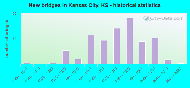
- New bridges - historical statistics
- 21900-1909
- 21920-1929
- 271930-1939
- 101940-1949
- 581950-1959
- 471960-1969
- 711970-1979
- 911980-1989
- 451990-1999
- 522000-2009
- 92010-2019
- 12020-2022
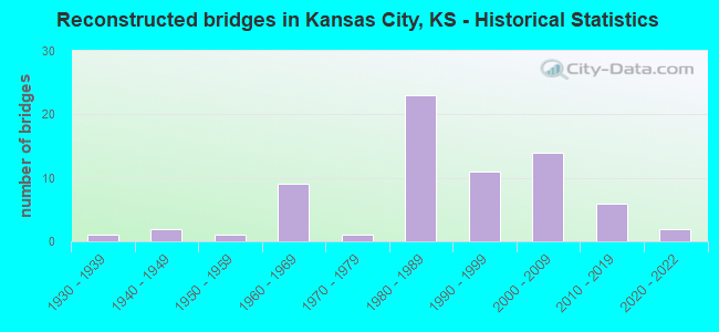
- Reconstructed bridges - Historical Statistics
- 11930-1939
- 21940-1949
- 11950-1959
- 91960-1969
- 11970-1979
- 231980-1989
- 111990-1999
- 142000-2009
- 62010-2019
- 22020-2022
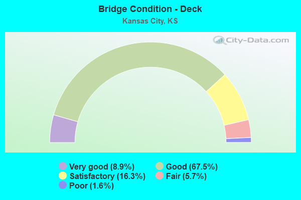
- Bridge Condition - Deck
- 8.9%Very good
- 67.5%Good
- 16.3%Satisfactory
- 5.7%Fair
- 1.6%Poor
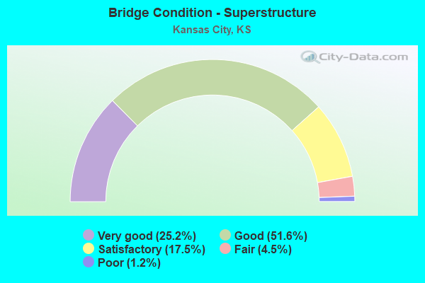
- Bridge Condition - Superstructure
- 25.2%Very good
- 51.6%Good
- 17.5%Satisfactory
- 4.5%Fair
- 1.2%Poor
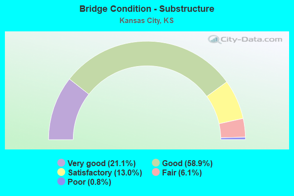
- Bridge Condition - Substructure
- 21.1%Very good
- 58.9%Good
- 13.0%Satisfactory
- 6.1%Fair
- 0.8%Poor
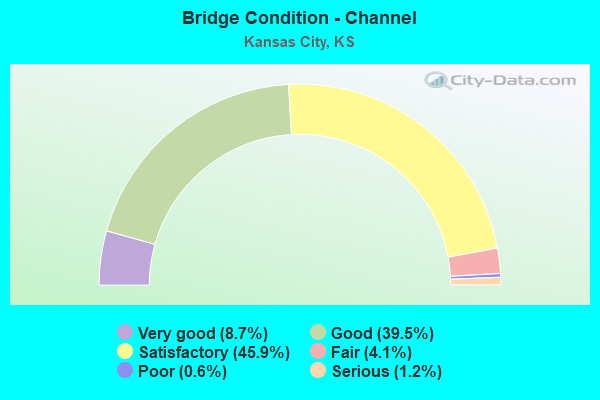
- Bridge Condition - Channel
- 8.7%Very good
- 39.5%Good
- 45.9%Satisfactory
- 4.1%Fair
- 0.6%Poor
- 1.2%Serious
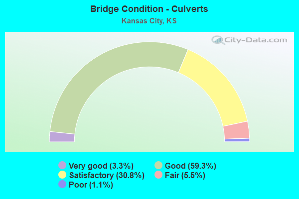
- Bridge Condition - Culverts
- 3.3%Very good
- 59.3%Good
- 30.8%Satisfactory
- 5.5%Fair
- 1.1%Poor
Find on map >> Show street view
Structure Number: 999963501053071, Location: .65 MI N US-24/I-635 JCT (Lat: 39.125000, Lng: -94.677222), Route carried "on" structure: Interstate 635, Year Built: 2004, Status: Open, Structure Length: 5.00m (16.40ft), Average Daily Traffic: 29,412 (year 2020), Truck Traffic: 11%, Average Future Daily Traffic: 35,184 (year 2041), Design Load: HS 20, Features Intersected: VICTORY DRIVE
Minimum Vertical Clearance: 30.47m (99.97ft), Kilometerpoint: 9.215, Lanes on structure: 4, Lanes under structure: 2, Base Highway Network: Yes, Owner: State Highway Agency, Approaching Roadway Width: 16.5m (54.1ft), Material/Design: Concrete continuous, Design/Construction: Slab, Number Of Spans In Main Unit: 3, Length of Maximum Span: 19.2m (63.0ft), Curb-To-Curb Width: 20.2m (66.3ft), Out-to-Out Width: 20.9m (68.6ft)
Condition: Deck: Good, Superstructure: Very good, Substructure: Very good, Operating Rating: 71.7 metric tons, Method Used To Determine Operating Rating: Load Factor (LF), Inventory Rating: 43.5 metric tons, Method Used To Determine Inventory Rating: Load Factor (LF), Structural Evaluation: Equal to present desirable criteria, Deck Geometry: Equal to present minimum criteria, Underclear: Superior to present desirable criteria, Approach Roadway Alignment: Equal to present desirable criteria, Length Of Structure Improvement: 16.39m (53.77ft), Designated Inspection Frequency: Every 24 months, Inspection Date: June 2021, Wearing Surface/Protective System: Wearing Surface: Monolithic Concrete, Deck Protection: Epoxy Coated Reinforcing
Find on map >> Show street view
Structure Number: 999963501053081, Location: .65 MI N US-24/I-635 JCT (Lat: 39.125000, Lng: -94.676944), Route carried "on" structure: Interstate 635, Year Built: 2004, Status: Open, Structure Length: 5.00m (16.40ft), Average Daily Traffic: 29,412 (year 2020), Truck Traffic: 11%, Average Future Daily Traffic: 35,184 (year 2041), Design Load: HS 25 or greater, Features Intersected: VICTORY DRIVE
Minimum Vertical Clearance: 30.47m (99.97ft), Kilometerpoint: 9.347, Lanes on structure: 3, Lanes under structure: 2, Base Highway Network: Yes, Owner: State Highway Agency, Approaching Roadway Width: 16.5m (54.1ft), Material/Design: Concrete continuous, Design/Construction: Slab, Number Of Spans In Main Unit: 3, Length of Maximum Span: 19.2m (63.0ft), Curb-To-Curb Width: 20.2m (66.3ft), Out-to-Out Width: 20.9m (68.6ft)
Condition: Deck: Good, Superstructure: Good, Substructure: Good, Operating Rating: 71.7 metric tons, Method Used To Determine Operating Rating: Load Factor (LF), Inventory Rating: 43.5 metric tons, Method Used To Determine Inventory Rating: Load Factor (LF), Structural Evaluation: Better than present minimum criteria, Deck Geometry: Superior to present desirable criteria, Underclear: Superior to present desirable criteria, Approach Roadway Alignment: Equal to present desirable criteria, Length Of Structure Improvement: 16.39m (53.77ft), Designated Inspection Frequency: Every 24 months, Inspection Date: June 2021, Wearing Surface/Protective System: Wearing Surface: Monolithic Concrete, Deck Protection: Epoxy Coated Reinforcing
Find on map >> Show street view
Structure Number: 999963501053091, Location: 2.2 MI N US-24/I-635 JCT (Lat: 39.142778, Lng: -94.670556), Route carried "on" structure: Interstate 635, Year Built: 2005, Status: Open, Structure Length: 6.12m (20.08ft), Average Daily Traffic: 24,736 (year 2020), Truck Traffic: 13%, Average Future Daily Traffic: 31,401 (year 2041), Design Load: HS 25 or greater, Features Intersected: LEAVENWORTH ROAD
Minimum Vertical Clearance: 30.47m (99.97ft), Kilometerpoint: 11.476, Lanes on structure: 3, Lanes under structure: 4, Base Highway Network: Yes, Owner: State Highway Agency, Approaching Roadway Width: 17.1m (56.1ft), Skew: 3 degrees, Material/Design: Concrete continuous, Design/Construction: Slab, Number Of Spans In Main Unit: 4, Length of Maximum Span: 15.8m (51.8ft), Curb-To-Curb Width: 17.1m (56.1ft), Out-to-Out Width: 17.9m (58.7ft)
Condition: Deck: Good, Superstructure: Very good, Substructure: Very good, Operating Rating: 88.9 metric tons, Method Used To Determine Operating Rating: Load Factor (LF), Inventory Rating: 53.5 metric tons, Method Used To Determine Inventory Rating: Load Factor (LF), Structural Evaluation: Equal to present desirable criteria, Deck Geometry: Equal to present minimum criteria, Underclear: Meets minimum limits, Approach Roadway Alignment: Equal to present desirable criteria, Length Of Structure Improvement: 20.07m (65.85ft), Designated Inspection Frequency: Every 24 months, Inspection Date: June 2021, Wearing Surface/Protective System: Wearing Surface: Monolithic Concrete, Deck Protection: Epoxy Coated Reinforcing
Find on map >> Show street view
Structure Number: 999963501053101, Location: 2.36 MI N US-24/I-635 JCT (Lat: 39.144722, Lng: -94.668889), Route carried "on" structure: ServiceCity street 164, Year Built: 2004, Status: Open, Structure Length: 5.34m (17.52ft), Average Daily Traffic: 528 (year 2020), Truck Traffic: 1%, Average Future Daily Traffic: 33,577 (year 2041), Design Load: HS 20, Features Intersected: I-635 HWY, Facility Carried by Structure: 34TH ST
Minimum Vertical Clearance: 30.47m (99.97ft), Kilometerpoint: 0.492, Lanes on structure: 2, Lanes under structure: 8, Owner: State Highway Agency, Approaching Roadway Width: 9.2m (30.2ft), Material/Design: Steel continuous, Design/Construction: Stringer/Multi-beam, Number Of Spans In Main Unit: 2, Length of Maximum Span: 26.3m (86.3ft), Curb or Sidewalk Widths: Left: 1.5m (4.9ft), Right: 1.5m (4.9ft), Curb-To-Curb Width: 9.8m (32.2ft), Out-to-Out Width: 13.4m (44.0ft)
Condition: Deck: Very good, Superstructure: Good, Substructure: Very good, Operating Rating: 40.2 metric tons, Method Used To Determine Operating Rating: Load and Resistance Factor Rating (LRFR) rating reported by rating factor(RF) method using HL-93 loadings, Inventory Rating: 31.1 metric tons, Method Used To Determine Inventory Rating: Load and Resistance Factor Rating (LRFR) rating reported by rating factor(RF) method using HL-93 loadings, Structural Evaluation: Better than present minimum criteria, Deck Geometry: Equal to present minimum criteria, Underclear: Meets minimum limits, Approach Roadway Alignment: Meets minimum limits, Length Of Structure Improvement: 17.51m (57.45ft), Designated Inspection Frequency: Every 24 months, Inspection Date: June 2021, Wearing Surface/Protective System: Wearing Surface: Monolithic Concrete, Deck Protection: Epoxy Coated Reinforcing
Find on map >> Show street view
Structure Number: 999963501053111, Location: .87 MI N US-24/I-635 JCT (Lat: 39.128333, Lng: -94.676667), Route carried "on" structure: City street 2524, Year Built: 2005, Status: Open, Structure Length: 4.73m (15.52ft), Average Daily Traffic: 4,921 (year 2020), Truck Traffic: 7%, Average Future Daily Traffic: 5,437 (year 2041), Design Load: HS 20, Features Intersected: I-635 HWY, Facility Carried by Structure: PARALLEL, WB
Minimum Vertical Clearance: 30.47m (99.97ft), Kilometerpoint: 19.442, Lanes on structure: 2, Lanes under structure: 6, Owner: State Highway Agency, Approaching Roadway Width: 10.6m (34.8ft), Material/Design: Steel continuous, Design/Construction: Stringer/Multi-beam, Number Of Spans In Main Unit: 2, Length of Maximum Span: 23.3m (76.4ft), Curb or Sidewalk Widths: Left: 8.5m (27.9ft), Right: 0.0m, Curb-To-Curb Width: 11.2m (36.7ft), Out-to-Out Width: 20.8m (68.2ft)
Condition: Deck: Good, Superstructure: Very good, Substructure: Very good, Operating Rating: 28.5 metric tons, Method Used To Determine Operating Rating: Load and Resistance Factor Rating (LRFR) rating reported by rating factor(RF) method using HL-93 loadings, Inventory Rating: 22.0 metric tons, Method Used To Determine Inventory Rating: Load and Resistance Factor Rating (LRFR) rating reported by rating factor(RF) method using HL-93 loadings, Structural Evaluation: Somewhat better than minimum adequacy, Deck Geometry: Somewhat better than minimum adequacy, Underclear: Equal to present minimum criteria, Approach Roadway Alignment: Somewhat better than minimum adequacy, Length Of Structure Improvement: 15.52m (50.92ft), Designated Inspection Frequency: Every 24 months, Inspection Date: June 2021, Wearing Surface/Protective System: Wearing Surface: Low Slump Concrete, Deck Protection: Epoxy Coated Reinforcing
Find on map >> Show street view
Structure Number: 999963501053121, Location: 2.2 MI N US-24/I-635 JCT (Lat: 39.142778, Lng: -94.670833), Route carried "on" structure: Interstate 635, Year Built: 2004, Status: Open, Structure Length: 6.02m (19.75ft), Average Daily Traffic: 24,736 (year 2020), Truck Traffic: 13%, Average Future Daily Traffic: 29,591 (year 2041), Design Load: HS 20, Features Intersected: LEAVENWORTH RD
Minimum Vertical Clearance: 30.47m (99.97ft), Kilometerpoint: 11.341, Lanes on structure: 3, Lanes under structure: 4, Base Highway Network: Yes, Owner: State Highway Agency, Approaching Roadway Width: 17.1m (56.1ft), Skew: 3 degrees, Material/Design: Concrete continuous, Design/Construction: Slab, Number Of Spans In Main Unit: 4, Length of Maximum Span: 15.8m (51.8ft), Curb-To-Curb Width: 17.1m (56.1ft), Out-to-Out Width: 17.9m (58.7ft)
Condition: Deck: Very good, Superstructure: Very good, Substructure: Very good, Operating Rating: 88.9 metric tons, Method Used To Determine Operating Rating: Load Factor (LF), Inventory Rating: 53.5 metric tons, Method Used To Determine Inventory Rating: Load Factor (LF), Structural Evaluation: Equal to present desirable criteria, Deck Geometry: Equal to present minimum criteria, Underclear: Meets minimum limits, Approach Roadway Alignment: Equal to present desirable criteria, Length Of Structure Improvement: 19.74m (64.76ft), Designated Inspection Frequency: Every 24 months, Inspection Date: June 2021, Wearing Surface/Protective System: Wearing Surface: Monolithic Concrete, Deck Protection: Epoxy Coated Reinforcing
Find on map >> Show street view
Structure Number: 999963501053261, Location: 1.43 MILES N I 35 (Lat: 39.058611, Lng: -94.679167), Route carried "on" structure: City street 2662, Year Built: 2015, Status: Open, Structure Length: 7.44m (24.41ft), Average Daily Traffic: 2,014 (year 2020), Truck Traffic: 5%, Average Future Daily Traffic: 2,055 (year 2041), Design Load: HL 93, Features Intersected: I 635 HWY, Facility Carried by Structure: GIBBS ROAD
Minimum Vertical Clearance: 30.47m (99.97ft), Kilometerpoint: 3.281, Lanes on structure: 2, Lanes under structure: 7, Owner: State Highway Agency, Approaching Roadway Width: 9.8m (32.2ft), Material/Design: Steel continuous, Design/Construction: Stringer/Multi-beam, Number Of Spans In Main Unit: 2, Length of Maximum Span: 36.6m (120.1ft), Curb or Sidewalk Widths: Left: 1.5m (4.9ft), Right: 0.0m, Curb-To-Curb Width: 9.8m (32.2ft), Out-to-Out Width: 10.5m (34.4ft)
Condition: Deck: Very good, Superstructure: Very good, Substructure: Very good, Operating Rating: 52.8 metric tons, Method Used To Determine Operating Rating: Load and Resistance Factor Rating (LRFR) rating reported by rating factor(RF) method using HL-93 loadings, Inventory Rating: 40.8 metric tons, Method Used To Determine Inventory Rating: Load and Resistance Factor Rating (LRFR) rating reported by rating factor(RF) method using HL-93 loadings, Structural Evaluation: Equal to present desirable criteria, Deck Geometry: Meets minimum limits, Underclear: Somewhat better than minimum adequacy, Approach Roadway Alignment: Somewhat better than minimum adequacy, Length Of Structure Improvement: 24.40m (80.05ft), Designated Inspection Frequency: Every 24 months, Inspection Date: June 2021, Wearing Surface/Protective System: Wearing Surface: Monolithic Concrete, Deck Protection: Epoxy Coated Reinforcing
Find on map >> Show street view
Structure Number: 999967001052411, Location: 0.29 MI E MILL ST. (Lat: 39.094167, Lng: -94.626667), Route carried "on" structure: Interstate 670, Year Built: 1990, Status: Open, Structure Length: 45.67m (149.84ft), Average Daily Traffic: 30,768 (year 2020), Truck Traffic: 11%, Average Future Daily Traffic: 45,720 (year 2041), Design Load: HS 20+Mod, Features Intersected: US69(7TH ST) 4 RAMPS
Minimum Vertical Clearance: 30.47m (99.97ft), Kilometerpoint: 0.711, Lanes on structure: 3, Lanes under structure: 8, Base Highway Network: Yes, Owner: State Highway Agency, Approaching Roadway Width: 17.1m (56.1ft), Skew: 3 degrees, Material/Design: Steel continuous, Design/Construction: Stringer/Multi-beam, Number Of Spans In Main Unit: 15, Length of Maximum Span: 80.8m (265.1ft), Curb-To-Curb Width: 17.1m (56.1ft), Out-to-Out Width: 17.9m (58.7ft)
Condition: Deck: Good, Superstructure: Good, Substructure: Very good, Operating Rating: 52.9 metric tons, Method Used To Determine Operating Rating: Load Factor (LF), Inventory Rating: 31.7 metric tons, Method Used To Determine Inventory Rating: Load Factor (LF), Structural Evaluation: Better than present minimum criteria, Deck Geometry: Equal to present minimum criteria, Underclear: Meets minimum limits, Approach Roadway Alignment: Somewhat better than minimum adequacy, Length Of Structure Improvement: 149.82m (491.54ft), Designated Inspection Frequency: Every 24 months, Inspection Date: June 2021, Wearing Surface/Protective System: Wearing Surface: Low Slump Concrete, Deck Protection: Epoxy Coated Reinforcing
Find on map >> Show street view
Structure Number: 999967001052421, Location: 0.36 MI E MILL ST. (Lat: 39.094444, Lng: -94.625278), Route carried "on" structure: Interstate 670, Year Built: 1990, Status: Open, Structure Length: 44.34m (145.47ft), Average Daily Traffic: 30,768 (year 2020), Truck Traffic: 11%, Average Future Daily Traffic: 45,720 (year 2041), Design Load: HS 20+Mod, Features Intersected: 169(7TH ST) & WB I-70 RP
Minimum Vertical Clearance: 30.47m (99.97ft), Kilometerpoint: 0.962, Lanes on structure: 3, Lanes under structure: 10, Base Highway Network: Yes, Owner: State Highway Agency, Approaching Roadway Width: 17.1m (56.1ft), Material/Design: Steel continuous, Design/Construction: Stringer/Multi-beam, Number Of Spans In Main Unit: 14, Length of Maximum Span: 50.9m (167.0ft), Curb-To-Curb Width: 17.1m (56.1ft), Out-to-Out Width: 17.9m (58.7ft)
Condition: Deck: Good, Superstructure: Good, Substructure: Good, Operating Rating: 57.5 metric tons, Method Used To Determine Operating Rating: Load Factor (LF), Inventory Rating: 34.5 metric tons, Method Used To Determine Inventory Rating: Load Factor (LF), Structural Evaluation: Better than present minimum criteria, Deck Geometry: Equal to present minimum criteria, Underclear: Somewhat better than minimum adequacy, Approach Roadway Alignment: Equal to present desirable criteria, Length Of Structure Improvement: 145.45m (477.20ft), Designated Inspection Frequency: Every 12 months, Critical Feature Inspection Frequency: Every 24 months, Inspection Date: June 2021, Critical Feature Inspection Date: March 2021, Wearing Surface/Protective System: Wearing Surface: Low Slump Concrete, Deck Protection: Epoxy Coated Reinforcing
Find on map >> Show street view
Structure Number: 999967001052431, Location: 1.06 MI E MILL ST. (Lat: 39.098611, Lng: -94.612778), Route carried "on" structure: Interstate 670, Year Built: 1990, Status: Open, Structure Length: 161.42m (529.59ft), Average Daily Traffic: 30,768 (year 2020), Truck Traffic: 11%, Average Future Daily Traffic: 45,720 (year 2041), Design Load: HS 20+Mod, Features Intersected: I70 HWY,3RPS,KS RV,RR'S
Minimum Vertical Clearance: 30.47m (99.97ft), Kilometerpoint: 2.111, Lanes on structure: 3, Lanes under structure: 11, Base Highway Network: Yes, Owner: State Highway Agency, Approaching Roadway Width: 17.1m (56.1ft), Material/Design: Steel continuous, Design/Construction: Girder and Floorbeam System, Number Of Spans In Main Unit: 4, Number Of Approach Spans: 45, Length of Maximum Span: 76.2m (250.0ft), Curb-To-Curb Width: 17.1m (56.1ft), Out-to-Out Width: 17.9m (58.7ft)
Condition: Deck: Good, Superstructure: Good, Substructure: Satisfactory, Channel: Very good, Operating Rating: 41.7 metric tons, Method Used To Determine Operating Rating: Load Factor (LF), Inventory Rating: 24.5 metric tons, Method Used To Determine Inventory Rating: Load Factor (LF), Structural Evaluation: Equal to present minimum criteria, Deck Geometry: Equal to present minimum criteria, Underclear: Somewhat better than minimum adequacy, Waterway Adequacy: Equal to present desirable criteria, Approach Roadway Alignment: Equal to present desirable criteria, Length Of Structure Improvement: 529.58m (1737.47ft), Designated Inspection Frequency: Every 24 months, Underwater Inspection Frequency: Every 60 months, Inspection Date: June 2021, Underwater Inspection Date: October 2020, Wearing Surface/Protective System: Wearing Surface: Low Slump Concrete, Deck Protection: Epoxy Coated Reinforcing
Find on map >> Show street view
Structure Number: 999967001052441, Location: 1.06 MI E MILL ST. (Lat: 39.098889, Lng: -94.612778), Route carried "on" structure: Interstate 670, Year Built: 1990, Status: Open, Structure Length: 161.83m (530.94ft), Average Daily Traffic: 30,768 (year 2020), Truck Traffic: 11%, Average Future Daily Traffic: 45,720 (year 2041), Design Load: HS 20+Mod, Features Intersected: 70 HWY 3RPS,KS RV, RR'S
Minimum Vertical Clearance: 30.47m (99.97ft), Kilometerpoint: 1.955, Lanes on structure: 3, Lanes under structure: 15, Base Highway Network: Yes, Owner: State Highway Agency, Approaching Roadway Width: 17.1m (56.1ft), Material/Design: Steel continuous, Design/Construction: Girder and Floorbeam System, Number Of Spans In Main Unit: 4, Number Of Approach Spans: 42, Length of Maximum Span: 76.2m (250.0ft), Curb-To-Curb Width: 17.1m (56.1ft), Out-to-Out Width: 17.9m (58.7ft)
Condition: Deck: Good, Superstructure: Good, Substructure: Good, Channel: Very good, Operating Rating: 40.8 metric tons, Method Used To Determine Operating Rating: Load Factor (LF), Inventory Rating: 24.5 metric tons, Method Used To Determine Inventory Rating: Load Factor (LF), Structural Evaluation: Equal to present minimum criteria, Deck Geometry: Equal to present minimum criteria, Underclear: Somewhat better than minimum adequacy, Waterway Adequacy: Equal to present desirable criteria, Approach Roadway Alignment: Equal to present desirable criteria, Length Of Structure Improvement: 530.92m (1741.86ft), Designated Inspection Frequency: Every 12 months, Critical Feature Inspection Frequency: Every 24 months, Underwater Inspection Frequency: Every 60 months, Inspection Date: June 2021, Critical Feature Inspection Date: March 2021, Underwater Inspection Date: October 2020, Wearing Surface/Protective System: Wearing Surface: Low Slump Concrete, Deck Protection: Epoxy Coated Reinforcing
Find on map >> Show street view
Structure Number: 999967001052451, Location: 0.92 MI E MILL ST. (Lat: 39.099444, Lng: -94.618611), Route carried "on" structure: Ramp State highway 43, Year Built: 1990, Status: Open, Structure Length: 78.02m (255.97ft), Average Daily Traffic: 3,610 (year 2020), Truck Traffic: 5%, Average Future Daily Traffic: 48,888 (year 2041), Design Load: HS 20+Mod, Features Intersected: KCT & MP & UP RAILROADS, Facility Carried by Structure: RAMP CE TO I670 EB
Minimum Vertical Clearance: 4.97m (16.31ft), Kilometerpoint: 0.423, Lanes on structure: 1, Lanes under structure: 4, Owner: State Highway Agency, Approaching Roadway Width: 7.3m (24.0ft), Material/Design: Steel continuous, Design/Construction: Girder and Floorbeam System, Number Of Spans In Main Unit: 28, Number Of Approach Spans: 8, Length of Maximum Span: 36.6m (120.1ft), Curb-To-Curb Width: 7.3m (24.0ft), Out-to-Out Width: 8.1m (26.6ft)
Condition: Deck: Good, Superstructure: Good, Substructure: Good, Operating Rating: 34.0 metric tons, Method Used To Determine Operating Rating: Load and Resistance Factor Rating (LRFR) rating reported by rating factor(RF) method using HL-93 loadings, Inventory Rating: 26.2 metric tons, Method Used To Determine Inventory Rating: Load and Resistance Factor Rating (LRFR) rating reported by rating factor(RF) method using HL-93 loadings, Structural Evaluation: Equal to present minimum criteria, Deck Geometry: Better than present minimum criteria, Underclear: Meets minimum limits, Approach Roadway Alignment: Better than present minimum criteria, Length Of Structure Improvement: 255.98m (839.83ft), Designated Inspection Frequency: Every 12 months, Critical Feature Inspection Frequency: Every 24 months, Inspection Date: April 2021, Critical Feature Inspection Date: April 2021, Wearing Surface/Protective System: Wearing Surface: Low Slump Concrete, Deck Protection: Epoxy Coated Reinforcing
Find on map >> Show street view
Structure Number: 999967001052471, Location: 0.86 MI E MILL ST. (Lat: 39.100833, Lng: -94.616944), Route carried "on" structure: Ramp State highway 43, Year Built: 1990, Status: Open, Structure Length: 74.01m (242.81ft), Average Daily Traffic: 3,570 (year 2020), Truck Traffic: 5%, Average Future Daily Traffic: 48,888 (year 2041), Design Load: HS 20+Mod, Features Intersected: CENTRAL AVE, UP RR, Facility Carried by Structure: I670 WB EXIT RP WC
Minimum Vertical Clearance: 30.47m (99.97ft), Kilometerpoint: 0.330, Lanes on structure: 1, Lanes under structure: 10, Owner: State Highway Agency, Approaching Roadway Width: 7.3m (24.0ft), Material/Design: Steel continuous, Design/Construction: Girder and Floorbeam System, Number Of Spans In Main Unit: 19, Number Of Approach Spans: 14, Length of Maximum Span: 49.1m (161.1ft), Curb-To-Curb Width: 7.3m (24.0ft), Out-to-Out Width: 8.1m (26.6ft)
Condition: Deck: Good, Superstructure: Good, Substructure: Satisfactory, Operating Rating: 32.7 metric tons, Method Used To Determine Operating Rating: Load and Resistance Factor Rating (LRFR) rating reported by rating factor(RF) method using HL-93 loadings, Inventory Rating: 25.3 metric tons, Method Used To Determine Inventory Rating: Load and Resistance Factor Rating (LRFR) rating reported by rating factor(RF) method using HL-93 loadings, Structural Evaluation: Equal to present minimum criteria, Deck Geometry: Better than present minimum criteria, Underclear: Meets minimum limits, Approach Roadway Alignment: High priority of replacement, Length Of Structure Improvement: 242.80m (796.59ft), Designated Inspection Frequency: Every 12 months, Critical Feature Inspection Frequency: Every 24 months, Inspection Date: August 2021, Critical Feature Inspection Date: April 2021, Wearing Surface/Protective System: Wearing Surface: Low Slump Concrete, Deck Protection: Epoxy Coated Reinforcing
Find on map >> Show street view
Structure Number: 999967001052481, Location: 0.03 MI W MISSOURI ST.LN. (Lat: 39.098333, Lng: -94.606944), Route carried "on" structure: Ramp State highway , Year Built: 1990, Status: Open, Structure Length: 8.74m (28.67ft), Average Daily Traffic: 4,000 (year 2020), Truck Traffic: 5%, Average Future Daily Traffic: 59,859 (year 2041), Design Load: HS 20+Mod, Features Intersected: TOPOGRAPHY & RR, Facility Carried by Structure: EB I670 EXIT RP WG
Minimum Vertical Clearance: 30.47m (99.97ft), Kilometerpoint: 0.212, Lanes on structure: 1, Owner: State Highway Agency, Approaching Roadway Width: 7.9m (25.9ft), Material/Design: Steel continuous, Design/Construction: Girder and Floorbeam System, Number Of Spans In Main Unit: 4, Length of Maximum Span: 30.0m (98.4ft), Curb-To-Curb Width: 7.9m (25.9ft), Out-to-Out Width: 8.7m (28.5ft)
Condition: Deck: Good, Superstructure: Good, Substructure: Good, Operating Rating: 57.2 metric tons, Method Used To Determine Operating Rating: Load Factor (LF), Inventory Rating: 34.5 metric tons, Method Used To Determine Inventory Rating: Load Factor (LF), Structural Evaluation: Better than present minimum criteria, Deck Geometry: Equal to present desirable criteria, Approach Roadway Alignment: Better than present minimum criteria, Length Of Structure Improvement: 28.66m (94.03ft), Designated Inspection Frequency: Every 12 months, Critical Feature Inspection Frequency: Every 24 months, Inspection Date: June 2021, Critical Feature Inspection Date: March 2021, Wearing Surface/Protective System: Wearing Surface: Low Slump Concrete, Deck Protection: Epoxy Coated Reinforcing
Find on map >> Show street view
Structure Number: 999967001052491, Location: 0.02 MI W MISSOURI ST.LN. (Lat: 39.099167, Lng: -94.606944), Route carried "on" structure: Ramp State highway , Year Built: 1990, Status: Open, Structure Length: 7.42m (24.34ft), Average Daily Traffic: 4,000 (year 2020), Truck Traffic: 5%, Average Future Daily Traffic: 48,888 (year 2041), Design Load: HS 20+Mod, Features Intersected: TOPOGRAPHY & RR, Facility Carried by Structure: RAMP GW TO WB I670
Minimum Vertical Clearance: 30.47m (99.97ft), Kilometerpoint: 0.035, Lanes on structure: 1, Owner: State Highway Agency, Approaching Roadway Width: 7.9m (25.9ft), Material/Design: Steel continuous, Design/Construction: Girder and Floorbeam System, Number Of Spans In Main Unit: 4, Length of Maximum Span: 27.6m (90.6ft), Curb-To-Curb Width: 7.9m (25.9ft), Out-to-Out Width: 8.7m (28.5ft)
Condition: Deck: Good, Superstructure: Good, Substructure: Good, Operating Rating: 69.9 metric tons, Method Used To Determine Operating Rating: Load Factor (LF), Inventory Rating: 41.7 metric tons, Method Used To Determine Inventory Rating: Load Factor (LF), Structural Evaluation: Better than present minimum criteria, Deck Geometry: Equal to present desirable criteria, Approach Roadway Alignment: Better than present minimum criteria, Length Of Structure Improvement: 24.36m (79.92ft), Designated Inspection Frequency: Every 12 months, Critical Feature Inspection Frequency: Every 24 months, Inspection Date: June 2021, Critical Feature Inspection Date: March 2021, Wearing Surface/Protective System: Wearing Surface: Low Slump Concrete, Deck Protection: Epoxy Coated Reinforcing
Find on map >> Show street view
Structure Number: 999900501051901, Location: 1.08 MILES E I-635 (Lat: 39.141944, Lng: -94.640556), Route carried "under" structure: State highway 5, Year Built: 1977, Structure Length: 0. m, Average Daily Traffic: 3,485 (year 2020), Truck Traffic: 14%, Features Intersected: K-5 HIGHWAY, Facility Carried by Structure: 12TH STREET
Minimum Vertical Clearance: 4.81m (15.78ft), Kilometerpoint: 1.891, Lanes on structure: 2, Lanes under structure: 4, Material/Design: Concrete continuous, Design/Construction: Box Beam or Girders - Multiple, Length of Maximum Span: 20.1m (65.9ft)
Find on map >> Show street view
Structure Number: 999900501051911, Location: 0.96 MI W OF US69 HWY (Lat: 39.141111, Lng: -94.636944), Route carried "under" structure: State highway 5, Year Built: 1976, Structure Length: 0. m, Average Daily Traffic: 3,485 (year 2020), Truck Traffic: 14%, Features Intersected: K-5 HIGHWAY, Facility Carried by Structure: PARKWOOD STREET
Minimum Vertical Clearance: 5.37m (17.62ft), Kilometerpoint: 1.564, Lanes on structure: 2, Lanes under structure: 4, Material/Design: Concrete continuous, Design/Construction: Slab, Length of Maximum Span: 15.5m (50.9ft)
Find on map >> Show street view
Structure Number: 999903201051031, Location: 32/TURNR DIAG/KAW DR INT (Lat: 39.097222, Lng: -94.723056), Route carried "under" structure: City street 2574, Year Built: 1959, Structure Length: 0. m, Average Daily Traffic: 8,940 (year 2020), Truck Traffic: 9%, Features Intersected: K-32 WB HIGHWAY, Facility Carried by Structure: K-32 EB HIGHWAY
Minimum Vertical Clearance: 4.38m (14.37ft), Kilometerpoint: 17.873, Lanes on structure: 2, Lanes under structure: 2, Material/Design: Concrete continuous, Design/Construction: Box Beam or Girders - Multiple, Length of Maximum Span: 21.3m (69.9ft)
Find on map >> Show street view
Structure Number: 999903501050021, Location: 0.15 MI NE JO COLN (Lat: 39.044722, Lng: -94.656111), Route carried "under" structure: Interstate 35, Year Built: 1959, Structure Length: 0. m, Average Daily Traffic: 52,371 (year 2020), Truck Traffic: 11%, Features Intersected: I-35 HWY, Facility Carried by Structure: LAMAR AVE.
Minimum Vertical Clearance: 4.82m (15.81ft), Kilometerpoint: 0.262, Lanes on structure: 2, Lanes under structure: 6, Material/Design: Concrete continuous, Design/Construction: Slab, Length of Maximum Span: 19.8m (65.0ft)
Find on map >> Show street view
Structure Number: 999903501050141, Location: JCT US169/I35, SB (Lat: 39.071111, Lng: -94.619167), Route carried "under" structure: US 169, Year Built: 1964, Structure Length: 0. m, Average Daily Traffic: 15,961 (year 2020), Truck Traffic: 9%, Features Intersected: US169 HWY(7TH ST TRFWY), Facility Carried by Structure: I35 HWY, SB
Minimum Vertical Clearance: 4.99m (16.37ft), Kilometerpoint: 3.289, Lanes on structure: 3, Lanes under structure: 4, Material/Design: Steel continuous, Design/Construction: Stringer/Multi-beam, Length of Maximum Span: 29.0m (95.1ft)
Find on map >> Show street view
Structure Number: 999903501050151, Location: JCT US169/I35, NB (Lat: 39.070833, Lng: -94.618889), Route carried "under" structure: US 169, Year Built: 1964, Structure Length: 0. m, Average Daily Traffic: 15,961 (year 2020), Truck Traffic: 9%, Features Intersected: US169 HWY(7TH ST TRFWY), Facility Carried by Structure: I35 HWY, NB
Minimum Vertical Clearance: 5.11m (16.77ft), Kilometerpoint: 3.272, Lanes on structure: 3, Lanes under structure: 4, Material/Design: Steel continuous, Design/Construction: Stringer/Multi-beam, Length of Maximum Span: 29.0m (95.1ft)
Find on map >> Show street view
Structure Number: 999906901051311, Location: 1.02 MILES N I-35 (Lat: 39.062222, Lng: -94.646667), Route carried "under" structure: US 69, Year Built: 1959, Structure Length: 0. m, Average Daily Traffic: 13,183 (year 2020), Truck Traffic: 5%, Features Intersected: US-69 HWY (18TH STREET), Facility Carried by Structure: URB2674, STEELE RD
Minimum Vertical Clearance: 4.72m (15.49ft), Kilometerpoint: 2.963, Lanes on structure: 2, Lanes under structure: 4, Material/Design: Steel continuous, Design/Construction: Stringer/Multi-beam, Length of Maximum Span: 25.0m (82.0ft)
Find on map >> Show street view
Structure Number: 999906901051421, Location: 0.36 MILES S I-70 (Lat: 39.087222, Lng: -94.649167), Route carried "under" structure: State highway 32, Year Built: 1959, Structure Length: 0. m, Average Daily Traffic: 10,072 (year 2020), Truck Traffic: 12%, Features Intersected: R32, UP RR,2 ST, Facility Carried by Structure: 69 HYW (18TH ST)
Minimum Vertical Clearance: 5.13m (16.83ft), Kilometerpoint: 24.438, Lanes on structure: 5, Lanes under structure: 5, Material/Design: Steel continuous, Design/Construction: Stringer/Multi-beam, Length of Maximum Span: 46.5m (152.6ft)
Find on map >> Show street view
Structure Number: 999906901052781, Location: JCT I35 & US69 (Lat: 39.047500, Lng: -94.646389), Route carried "under" structure: Interstate 35, Year Built: 1986, Structure Length: 0. m, Average Daily Traffic: 51,903 (year 2020), Truck Traffic: 11%, Features Intersected: I35 HWY N BND& S BND, Facility Carried by Structure: US69 (18TH ST) SB
Minimum Vertical Clearance: 4.93m (16.17ft), Kilometerpoint: 1.159, Lanes on structure: 3, Lanes under structure: 6, Material/Design: Steel continuous, Design/Construction: Stringer/Multi-beam, Length of Maximum Span: 24.1m (79.1ft)
Find on map >> Show street view
Structure Number: 999906901052831, Location: JCT I35 & US69 (Lat: 39.047778, Lng: -94.646111), Route carried "under" structure: Interstate 35, Year Built: 1986, Structure Length: 0. m, Average Daily Traffic: 51,903 (year 2020), Truck Traffic: 11%, Features Intersected: I35 HWY, Facility Carried by Structure: US69 (18TH ST) NB
Minimum Vertical Clearance: 4.95m (16.24ft), Kilometerpoint: 1.173, Lanes on structure: 3, Lanes under structure: 6, Material/Design: Steel continuous, Design/Construction: Stringer/Multi-beam, Length of Maximum Span: 24.1m (79.1ft)
Find on map >> Show street view
Structure Number: 999907001050211, Location: 0.82 MILES E US-69 W JCT (Lat: 39.091944, Lng: -94.635278), Route carried "under" structure: Interstate 670, Year Built: 1957, Structure Length: 0. m, Average Daily Traffic: 40,026 (year 2020), Truck Traffic: 11%, Features Intersected: I-70 HIGHWAY, Facility Carried by Structure: 10TH STREET
Minimum Vertical Clearance: 5.02m (16.47ft), Kilometerpoint: 24.336, Lanes on structure: 2, Lanes under structure: 8, Material/Design: Steel continuous, Design/Construction: Stringer/Multi-beam, Length of Maximum Span: 22.7m (74.5ft)
Find on map >> Show street view
Structure Number: 999907001050241, Location: I70/US169 & US69 E JCT (Lat: 39.094167, Lng: -94.625833), Route carried "under" structure: US 69, Year Built: 1957, Structure Length: 0. m, Average Daily Traffic: 12,526 (year 2020), Truck Traffic: 6%, Features Intersected: US-169 & US-69 NB, Facility Carried by Structure: I-70 WB HIGHWAY
Minimum Vertical Clearance: 4.87m (15.98ft), Kilometerpoint: 8.821, Lanes on structure: 3, Lanes under structure: 4, Material/Design: Steel continuous, Design/Construction: Stringer/Multi-beam, Length of Maximum Span: 31.8m (104.3ft)
Find on map >> Show street view
Structure Number: 999907001050271, Location: CENTRAL AVE/I70 E JCT (Lat: 39.102500, Lng: -94.621389), Route carried "under" structure: Interstate 70, Year Built: 1959, Structure Length: 0. m, Average Daily Traffic: 9,819 (year 2020), Truck Traffic: 36%, Features Intersected: 70 ,RR YARD, KANSAS RIV, Facility Carried by Structure: K-32 CENTRAL AVE
Minimum Vertical Clearance: 4.90m (16.08ft), Kilometerpoint: 26.255, Lanes on structure: 6, Lanes under structure: 5, Material/Design: Concrete continuous, Design/Construction: Box Beam or Girders - Multiple, Length of Maximum Span: 19.5m (64.0ft)
Find on map >> Show street view
Structure Number: 999907001050291, Location: 0.60 MILES W MO ST LINE (Lat: 39.113611, Lng: -94.616389), Route carried "under" structure: ServiceCity street 414, Year Built: 1959, Structure Length: 0. m, Average Daily Traffic: 4,892 (year 2020), Truck Traffic: 7%, Features Intersected: UP RR, 3 CITY STREETS, Facility Carried by Structure: I-70 EB HIGHWAY
Minimum Vertical Clearance: 5.30m (17.39ft), Kilometerpoint: 0.531, Lanes on structure: 2, Lanes under structure: 2, Material/Design: Steel continuous, Design/Construction: Stringer/Multi-beam, Length of Maximum Span: 22.9m (75.1ft)
Find on map >> Show street view
Structure Number: 999907001051741, Location: 0.57 MILES W MO ST LINE (Lat: 39.115833, Lng: -94.614444), Route carried "under" structure: ServiceCity street 596, Year Built: 1959, Structure Length: 0. m, Average Daily Traffic: 4,892 (year 2020), Truck Traffic: 7%, Features Intersected: 6 STREETS & 4 RR TRACKS, Facility Carried by Structure: SB FAIRFAX TO70EB
Minimum Vertical Clearance: 5.11m (16.77ft), Kilometerpoint: 25.177, Lanes on structure: 1, Lanes under structure: 1, Material/Design: Steel continuous, Design/Construction: Girder and Floorbeam System, Length of Maximum Span: 41.9m (137.5ft)
Find on map >> Show street view
Structure Number: 999907001051771, Location: 0.56 MILES W MO ST LINE (Lat: 39.113889, Lng: -94.616667), Route carried "under" structure: ServiceCity street 414, Year Built: 1962, Structure Length: 0. m, Average Daily Traffic: 4,892 (year 2020), Truck Traffic: 7%, Features Intersected: US-24 EB,UPRR, & 3 RAMPS, Facility Carried by Structure: I-70 WB HIGHWAY
Minimum Vertical Clearance: 5.10m (16.73ft), Kilometerpoint: 25.132, Lanes on structure: 3, Lanes under structure: 3, Material/Design: Steel continuous, Design/Construction: Stringer/Multi-beam, Length of Maximum Span: 41.1m (134.8ft)
Find on map >> Show street view
Structure Number: 999907001052383, Location: I-70 / US-69 W JCT (Lat: 39.096111, Lng: -94.649167), Route carried "under" structure: US 69, Year Built: 1980, Structure Length: 0. m, Average Daily Traffic: 18,032 (year 2020), Truck Traffic: 4%, Features Intersected: 69 SB HWY (18TH STREET), Facility Carried by Structure: I-70 WB HIGHWAY
Minimum Vertical Clearance: 5.01m (16.44ft), Kilometerpoint: 6.568, Lanes on structure: 5, Lanes under structure: 4, Material/Design: Steel continuous, Design/Construction: Stringer/Multi-beam, Length of Maximum Span: 31.4m (103.0ft)
Find on map >> Show street view
Structure Number: 999907001052393, Location: I-70 / US-69 W JCT (Lat: 39.095833, Lng: -94.649167), Route carried "under" structure: US 69, Year Built: 1980, Structure Length: 0. m, Average Daily Traffic: 18,032 (year 2020), Truck Traffic: 4%, Features Intersected: 69 SB HWY (18TH STREET), Facility Carried by Structure: I-70 EB HIGHWAY
Minimum Vertical Clearance: 5.45m (17.88ft), Kilometerpoint: 6.542, Lanes on structure: 4, Lanes under structure: 4, Material/Design: Steel continuous, Design/Construction: Stringer/Multi-beam, Length of Maximum Span: 31.4m (103.0ft)
Find on map >> Show street view
Structure Number: 999907001052501, Location: 1.07 MI E US69 (Lat: 39.091667, Lng: -94.630556), Route carried "under" structure: Interstate 670, Year Built: 1990, Structure Length: 0. m, Average Daily Traffic: 30,768 (year 2020), Truck Traffic: 12%, Features Intersected: I70 &I670 HWYS, Facility Carried by Structure: MILL ST
Minimum Vertical Clearance: 5.03m (16.50ft), Kilometerpoint: 24.744, Lanes on structure: 2, Lanes under structure: 4, Material/Design: Steel continuous, Design/Construction: Stringer/Multi-beam, Length of Maximum Span: 32.5m (106.6ft)
Find on map >> Show street view
Structure Number: 999907001052501, Location: 1.07 MI E US69 (Lat: 39.091667, Lng: -94.630556), Route carried "under" structure: Interstate 670, Year Built: 1990, Structure Length: 0. m, Average Daily Traffic: 30,768 (year 2020), Truck Traffic: 12%, Features Intersected: I70 &I670 HWYS, Facility Carried by Structure: MILL ST
Minimum Vertical Clearance: 4.97m (16.31ft), Kilometerpoint: 24.744, Lanes on structure: 2, Lanes under structure: 6, Material/Design: Steel continuous, Design/Construction: Stringer/Multi-beam, Length of Maximum Span: 32.5m (106.6ft)
Find on map >> Show street view
Structure Number: 999907001052571, Location: 3.51 MI E I435 (Lat: 39.106111, Lng: -94.745556), Route carried "under" structure: Interstate 70, Year Built: 1982, Structure Length: 0. m, Average Daily Traffic: 34,789 (year 2020), Truck Traffic: 11%, Features Intersected: I70 HWY (KTA), NL-SL, Facility Carried by Structure: LOCAL RD (72ND ST)
Minimum Vertical Clearance: 4.98m (16.34ft), Kilometerpoint: 14.402, Lanes on structure: 2, Lanes under structure: 8, Material/Design: Prestressed concrete continuous, Design/Construction: Stringer/Multi-beam, Length of Maximum Span: 26.2m (86.0ft)
Find on map >> Show street view
Structure Number: 999907001052661, Location: 1.09 MI E TURNER DIAG (Lat: 39.105278, Lng: -94.719167), Route carried "under" structure: Interstate 70, Year Built: 1985, Structure Length: 0. m, Average Daily Traffic: 36,051 (year 2020), Truck Traffic: 10%, Features Intersected: I70 NL-SL, Facility Carried by Structure: 61ST ST
Minimum Vertical Clearance: 5.01m (16.44ft), Kilometerpoint: 16.687, Lanes on structure: 2, Lanes under structure: 6, Material/Design: Prestressed concrete continuous, Design/Construction: Stringer/Multi-beam, Length of Maximum Span: 24.1m (79.1ft)
Find on map >> Show street view
Structure Number: 999907001052721, Location: 1.72 MI E I435 (Lat: 39.104722, Lng: -94.778889), Route carried "under" structure: Interstate 70, Year Built: 1986, Structure Length: 0. m, Average Daily Traffic: 31,843 (year 2020), Truck Traffic: 12%, Features Intersected: I70 HWY, NL-SL, Facility Carried by Structure: 86TH ST
Minimum Vertical Clearance: 4.99m (16.37ft), Kilometerpoint: 11.497, Lanes on structure: 2, Lanes under structure: 6, Material/Design: Prestressed concrete continuous, Design/Construction: Stringer/Multi-beam, Length of Maximum Span: 24.1m (79.1ft)
Find on map >> Show street view
Structure Number: 999907001052731, Location: I70 & TURNER DIAGONAL SB (Lat: 39.106111, Lng: -94.738889), Route carried "under" structure: City street 2501, Year Built: 1988, Structure Length: 0. m, Average Daily Traffic: 34,789 (year 2020), Truck Traffic: 12%, Features Intersected: I70 HWY, Facility Carried by Structure: K132 HWY SB
Minimum Vertical Clearance: 4.83m (15.85ft), Kilometerpoint: 14.944, Lanes on structure: 3, Lanes under structure: 7, Material/Design: Prestressed concrete continuous, Design/Construction: Stringer/Multi-beam, Length of Maximum Span: 24.7m (81.0ft)
Find on map >> Show street view
Structure Number: 999907001052741, Location: Turner Diag NB & I-70 (Lat: 39.106111, Lng: -94.739167), Route carried "under" structure: City street 2501, Year Built: 1988, Structure Length: 0. m, Average Daily Traffic: 34,789 (year 2020), Truck Traffic: 12%, Features Intersected: I70 HWY NL-NB, Facility Carried by Structure: TURNER DIAG.
Minimum Vertical Clearance: 5.14m (16.86ft), Kilometerpoint: 14.964, Lanes on structure: 2, Lanes under structure: 7, Material/Design: Prestressed concrete continuous, Design/Construction: Stringer/Multi-beam, Length of Maximum Span: 24.7m (81.0ft)
Find on map >> Show street view
Structure Number: 999907001052761, Location: 0.58 MI E TURNER DIAG. (Lat: 39.105833, Lng: -94.728333), Route carried "under" structure: Interstate 70, Year Built: 1988, Structure Length: 0. m, Average Daily Traffic: 36,051 (year 2020), Truck Traffic: 10%, Features Intersected: I-70 WB-EB, Facility Carried by Structure: 65TH ST
Minimum Vertical Clearance: 4.99m (16.37ft), Kilometerpoint: 15.876, Lanes on structure: 2, Lanes under structure: 6, Material/Design: Prestressed concrete continuous, Design/Construction: Stringer/Multi-beam, Length of Maximum Span: 23.9m (78.4ft)
Find on map >> Show street view
Structure Number: 999907001052911, Location: 2.35 MILES E K-7 (Lat: 39.105833, Lng: -94.835000), Route carried "under" structure: Interstate 70, Year Built: 1996, Structure Length: 0. m, Average Daily Traffic: 23,800 (year 2020), Truck Traffic: 15%, Features Intersected: I-70 HIGHWAY (KTA), Facility Carried by Structure: 110TH STREET
Minimum Vertical Clearance: 5.17m (16.96ft), Kilometerpoint: 6.645, Lanes on structure: 6, Lanes under structure: 4, Material/Design: Prestressed concrete continuous, Design/Construction: Stringer/Multi-beam, Length of Maximum Span: 22.3m (73.2ft)
Find on map >> Show street view
Structure Number: 999907001052983, Location: I-70 / I-635 INTERCHANGE (Lat: 39.103889, Lng: -94.678056), Route carried "under" structure: State highway 21, Year Built: 2004, Structure Length: 0. m, Average Daily Traffic: 32,872 (year 2020), Truck Traffic: 11%, Features Intersected: I-635 NB HIGHWAY, Facility Carried by Structure: I-70 EB HIGHWAY
Minimum Vertical Clearance: 5.32m (17.45ft), Kilometerpoint: 6.753, Lanes on structure: 3, Lanes under structure: 4, Material/Design: Steel continuous, Design/Construction: Stringer/Multi-beam, Length of Maximum Span: 40.0m (131.2ft)
Find on map >> Show street view
Structure Number: 999907001053003, Location: I-70 / I-635 INTERCHANGE (Lat: 39.104167, Lng: -94.680000), Route carried "under" structure: Interstate 635, Year Built: 2004, Structure Length: 0. m, Average Daily Traffic: 32,872 (year 2020), Truck Traffic: 10%, Features Intersected: I-635 SB HIGHWAY, Facility Carried by Structure: I-70 EB HIGHWAY
Minimum Vertical Clearance: 5.43m (17.81ft), Kilometerpoint: 6.759, Lanes on structure: 3, Lanes under structure: 3, Material/Design: Steel continuous, Design/Construction: Stringer/Multi-beam, Length of Maximum Span: 42.0m (137.8ft)
Find on map >> Show street view
Structure Number: 999907001053013, Location: I-70 / I-635 INTERCHANGE (Lat: 39.105000, Lng: -94.677778), Route carried "under" structure: Interstate 635, Year Built: 2004, Structure Length: 0. m, Average Daily Traffic: 32,872 (year 2020), Truck Traffic: 10%, Features Intersected: I-635 HIGHWAY, NB, Facility Carried by Structure: I-70 WB HIGHWAY
Minimum Vertical Clearance: 5.59m (18.34ft), Kilometerpoint: 6.896, Lanes on structure: 3, Lanes under structure: 3, Material/Design: Steel continuous, Design/Construction: Stringer/Multi-beam, Length of Maximum Span: 40.0m (131.2ft)
Find on map >> Show street view
Structure Number: 999907001053033, Location: I-70 / I-635 INTERCHANGE (Lat: 39.105556, Lng: -94.680556), Route carried "under" structure: State highway 21, Year Built: 2004, Structure Length: 0. m, Average Daily Traffic: 32,872 (year 2020), Truck Traffic: 11%, Features Intersected: I-635 SB HIGHWAY, Facility Carried by Structure: I-70 WB HIGHWAY
Minimum Vertical Clearance: 5.37m (17.62ft), Kilometerpoint: 6.911, Lanes on structure: 3, Lanes under structure: 4, Material/Design: Steel continuous, Design/Construction: Stringer/Multi-beam, Length of Maximum Span: 42.0m (137.8ft)
Find on map >> Show street view
Structure Number: 999907301053201, Location: U-73 HWY AT US-24 HWY (Lat: 39.115833, Lng: -94.894722), Route carried "under" structure: US 24, Year Built: 2009, Structure Length: 0. m, Average Daily Traffic: 7,665 (year 2020), Truck Traffic: 7%, Features Intersected: US-24 HWY, Facility Carried by Structure: NB U-73 HWY
Minimum Vertical Clearance: 5.42m (17.78ft), Kilometerpoint: 0.154, Lanes on structure: 3, Lanes under structure: 6, Material/Design: Steel continuous, Design/Construction: Stringer/Multi-beam, Length of Maximum Span: 54.0m (177.2ft)
Find on map >> Show street view
Structure Number: 999907301053211, Location: U-73 HWY AT US-24 HWY (Lat: 39.115833, Lng: -94.895000), Route carried "under" structure: US 24, Year Built: 2009, Structure Length: 0. m, Average Daily Traffic: 8,889 (year 2020), Truck Traffic: 9%, Features Intersected: US-24 HWY, Facility Carried by Structure: SB U-73 HWY
Minimum Vertical Clearance: 5.04m (16.54ft), Kilometerpoint: 1.136, Lanes on structure: 3, Lanes under structure: 8, Material/Design: Steel continuous, Design/Construction: Stringer/Multi-beam, Length of Maximum Span: 54.0m (177.2ft)
Find on map >> Show street view
Structure Number: 999916901050741, Location: US-169 / I-70 JCT (Lat: 39.093056, Lng: -94.625833), Route carried "under" structure: Interstate 70, Year Built: 1958, Structure Length: 0. m, Average Daily Traffic: 9,819 (year 2020), Truck Traffic: 36%, Features Intersected: I-70 EB HIGHWAY, Facility Carried by Structure: US-169 HIGHWAY
Minimum Vertical Clearance: 4.80m (15.75ft), Kilometerpoint: 25.138, Lanes on structure: 4, Lanes under structure: 2, Material/Design: Steel, Design/Construction: Stringer/Multi-beam, Length of Maximum Span: 40.2m (131.9ft)
Find on map >> Show street view
Structure Number: 999943501052131, Location: JCT I-70 NB (Lat: 39.106389, Lng: -94.810833), Route carried "under" structure: Interstate 70, Year Built: 1985, Structure Length: 0. m, Average Daily Traffic: 26,045 (year 2020), Truck Traffic: 15%, Features Intersected: I-70 HIGHWAY, Facility Carried by Structure: I-435 NORTHBOUND
Minimum Vertical Clearance: 5.25m (17.22ft), Kilometerpoint: 8.724, Lanes on structure: 4, Lanes under structure: 6, Material/Design: Steel continuous, Design/Construction: Frame, Length of Maximum Span: 42.1m (138.1ft)
Find on map >> Show street view
Structure Number: 999943501052141, Location: JCT I-70, SB (Lat: 39.106389, Lng: -94.811389), Route carried "under" structure: Interstate 70, Year Built: 1985, Structure Length: 0. m, Average Daily Traffic: 26,045 (year 2020), Truck Traffic: 15%, Features Intersected: I-70 HIGHWAY, Facility Carried by Structure: I-435 Hwy SB
Minimum Vertical Clearance: 4.75m (15.58ft), Kilometerpoint: 8.682, Lanes on structure: 4, Lanes under structure: 7, Material/Design: Steel continuous, Design/Construction: Frame, Length of Maximum Span: 42.1m (138.1ft)
Find on map >> Show street view
Structure Number: 999954001051781, Location: WB I70, US24 & MINN AVE (Lat: 39.114167, Lng: -94.616111), Route carried "under" structure: City street 3125, Year Built: 1962, Structure Length: 0. m, Average Daily Traffic: 4,892 (year 2020), Truck Traffic: 7%, Features Intersected: EB 24 & WB I70 & RR, Facility Carried by Structure: WB I70 TO WB MINN
Minimum Vertical Clearance: 5.01m (16.44ft), Kilometerpoint: 24.987, Lanes on structure: 1, Lanes under structure: 1, Material/Design: Steel continuous, Design/Construction: Girder and Floorbeam System, Length of Maximum Span: 38.1m (125.0ft)
Find on map >> Show street view
Structure Number: 999963501050321, Location: 1.02 MILES N I-35 (Lat: 39.053056, Lng: -94.679167), Route carried "under" structure: Interstate 635, Year Built: 1971, Structure Length: 0. m, Average Daily Traffic: 34,041 (year 2020), Truck Traffic: 9%, Features Intersected: I-635 HIGHWAY, Facility Carried by Structure: SHWN DR
Minimum Vertical Clearance: 5.16m (16.93ft), Kilometerpoint: 1.078, Lanes on structure: 4, Lanes under structure: 6, Material/Design: Steel continuous, Design/Construction: Stringer/Multi-beam, Length of Maximum Span: 27.7m (90.9ft)
Find on map >> Show street view
Structure Number: 999963501050361, Location: 1.11 MI S OLD K132 (Lat: 39.073056, Lng: -94.680278), Route carried "under" structure: City street 2672, Year Built: 1971, Structure Length: 0. m, Average Daily Traffic: 34,041 (year 2020), Truck Traffic: 10%, Features Intersected: I-635 HIGHWAY, Facility Carried by Structure: METROPOLITAN AVE
Minimum Vertical Clearance: 4.98m (16.34ft), Kilometerpoint: 3.302, Lanes on structure: 5, Lanes under structure: 7, Material/Design: Concrete continuous, Design/Construction: Box Beam or Girders - Multiple, Length of Maximum Span: 21.9m (71.9ft)
Find on map >> Show street view
Structure Number: 999963501050371, Location: 0.97 MI S OLD K132 (Lat: 39.075278, Lng: -94.680278), Route carried "under" structure: Ramp State highway 36, Year Built: 1971, Structure Length: 0. m, Average Daily Traffic: 33,620 (year 2020), Truck Traffic: 9%, Features Intersected: I-635 HIGHWAY, Facility Carried by Structure: STRONG AVE
Minimum Vertical Clearance: 4.99m (16.37ft), Kilometerpoint: 3.558, Lanes on structure: 2, Lanes under structure: 8, Material/Design: Concrete continuous, Design/Construction: Box Beam or Girders - Multiple, Length of Maximum Span: 25.9m (85.0ft)
Find on map >> Show street view
Structure Number: 999963501050401, Location: I-635/K-32 JCT (Lat: 39.085000, Lng: -94.680556), Route carried "under" structure: ServiceCity street 1040, Year Built: 1970, Structure Length: 0. m, Average Daily Traffic: 9,294 (year 2020), Truck Traffic: 8%, Features Intersected: K-32 HWY, BNSF RR YARD, Facility Carried by Structure: I-635 SB HIGHWAY
Minimum Vertical Clearance: 7.62m (25.00ft), Kilometerpoint: 21.786, Lanes on structure: 3, Lanes under structure: 6, Material/Design: Steel continuous, Design/Construction: Stringer/Multi-beam, Length of Maximum Span: 40.5m (132.9ft)
Find on map >> Show street view
Structure Number: 999963501050411, Location: I-635/K-32 JCT (Lat: 39.085000, Lng: -94.680278), Route carried "under" structure: ServiceCity street 1040, Year Built: 1970, Structure Length: 0. m, Average Daily Traffic: 9,294 (year 2020), Truck Traffic: 8%, Features Intersected: K-32 HWY, BNSF RR YARD, Facility Carried by Structure: I-635 NB HIGHWAY
Minimum Vertical Clearance: 7.62m (25.00ft), Kilometerpoint: 21.808, Lanes on structure: 3, Lanes under structure: 6, Material/Design: Steel continuous, Design/Construction: Stringer/Multi-beam, Length of Maximum Span: 39.8m (130.6ft)
Find on map >> Show street view
Structure Number: 999963501050461, Location: 0.36 MILES N I-7O (Lat: 39.109444, Lng: -94.681389), Route carried "under" structure: Interstate 635, Year Built: 1973, Structure Length: 0. m, Average Daily Traffic: 32,872 (year 2020), Truck Traffic: 10%, Features Intersected: I-635 HIGHWAY, Facility Carried by Structure: ORVILLE AVE
Minimum Vertical Clearance: 5.28m (17.32ft), Kilometerpoint: 7.467, Lanes on structure: 4, Lanes under structure: 8, Material/Design: Steel continuous, Design/Construction: Stringer/Multi-beam, Length of Maximum Span: 48.8m (160.1ft)
Find on map >> Show street view
Structure Number: 999963501050551, Location: 1.38 MILES N US-24 (Lat: 39.135556, Lng: -94.675833), Route carried "under" structure: Interstate 635, Year Built: 1968, Structure Length: 0. m, Average Daily Traffic: 25,905 (year 2020), Truck Traffic: 12%, Features Intersected: I-635 HIGHWAY, Facility Carried by Structure: GEORGIA AVE
Minimum Vertical Clearance: 5.20m (17.06ft), Kilometerpoint: 10.511, Lanes on structure: 2, Lanes under structure: 6, Material/Design: Concrete continuous, Design/Construction: Box Beam or Girders - Multiple, Length of Maximum Span: 17.7m (58.1ft)
Find on map >> Show street view
Structure Number: 999963501051521, Location: I-70 / I-635 INTERCHANGE (Lat: 39.104167, Lng: -94.677778), Route carried "under" structure: City street 2574, Year Built: 1974, Structure Length: 0. m, Average Daily Traffic: 39,605 (year 2020), Truck Traffic: 11%, Features Intersected: I-635 NB,& I-70 HIGHWAYS, Facility Carried by Structure: I70 WB TO I635 SB
Minimum Vertical Clearance: 30.47m (99.97ft), Kilometerpoint: 20.403, Lanes on structure: 4, Lanes under structure: 4, Material/Design: Steel continuous, Design/Construction: Stringer/Multi-beam, Length of Maximum Span: 50.9m (167.0ft)
Find on map >> Show street view
Structure Number: 999963501051521, Location: I-70 / I-635 INTERCHANGE (Lat: 39.104167, Lng: -94.677778), Route carried "under" structure: City street 2574, Year Built: 1974, Structure Length: 0. m, Average Daily Traffic: 39,605 (year 2020), Truck Traffic: 11%, Features Intersected: I-635 NB,& I-70 HIGHWAYS, Facility Carried by Structure: I70 WB TO I635 SB
Minimum Vertical Clearance: 5.13m (16.83ft), Kilometerpoint: 20.403, Lanes on structure: 6, Lanes under structure: 6, Material/Design: Steel continuous, Design/Construction: Stringer/Multi-beam, Length of Maximum Span: 50.9m (167.0ft)
Find on map >> Show street view
Structure Number: 999963501051521, Location: I-70 / I-635 INTERCHANGE (Lat: 39.104167, Lng: -94.677778), Route carried "under" structure: City street 2574, Year Built: 1974, Structure Length: 0. m, Average Daily Traffic: 39,605 (year 2020), Truck Traffic: 11%, Features Intersected: I-635 NB,& I-70 HIGHWAYS, Facility Carried by Structure: I70 WB TO I635 SB
Minimum Vertical Clearance: 7.62m (25.00ft), Kilometerpoint: 20.403, Lanes on structure: 3, Lanes under structure: 3, Material/Design: Steel continuous, Design/Construction: Stringer/Multi-beam, Length of Maximum Span: 50.9m (167.0ft)
Find on map >> Show street view
Structure Number: 999963501051521, Location: I-70 / I-635 INTERCHANGE (Lat: 39.104167, Lng: -94.677778), Route carried "under" structure: City street 2574, Year Built: 1974, Structure Length: 0. m, Average Daily Traffic: 39,605 (year 2020), Truck Traffic: 11%, Features Intersected: I-635 NB,& I-70 HIGHWAYS, Facility Carried by Structure: I70 WB TO I635 SB
Minimum Vertical Clearance: 7.62m (25.00ft), Kilometerpoint: 20.403, Lanes on structure: 1, Lanes under structure: 1, Material/Design: Steel continuous, Design/Construction: Stringer/Multi-beam, Length of Maximum Span: 50.9m (167.0ft)
Find on map >> Show street view
Structure Number: 999963501051521, Location: I-70 / I-635 INTERCHANGE (Lat: 39.104167, Lng: -94.677778), Route carried "under" structure: City street 2574, Year Built: 1974, Structure Length: 0. m, Average Daily Traffic: 39,605 (year 2020), Truck Traffic: 11%, Features Intersected: I-635 NB,& I-70 HIGHWAYS, Facility Carried by Structure: I70 WB TO I635 SB
Minimum Vertical Clearance: 6.94m (22.77ft), Kilometerpoint: 20.403, Lanes on structure: 1, Lanes under structure: 1, Material/Design: Steel continuous, Design/Construction: Stringer/Multi-beam, Length of Maximum Span: 50.9m (167.0ft)
Find on map >> Show street view
Structure Number: 999963501051571, Location: I-70 / I-635 INTERCHANGE (Lat: 39.105556, Lng: -94.680278), Route carried "under" structure: State highway 21, Year Built: 1975, Structure Length: 0. m, Average Daily Traffic: 39,605 (year 2020), Truck Traffic: 11%, Features Intersected: I-70 WB, I-635 SB, 2 RPS, Facility Carried by Structure: I70 EB TO I635 NB
Minimum Vertical Clearance: 5.33m (17.49ft), Kilometerpoint: 20.077, Lanes on structure: 1, Lanes under structure: 4, Material/Design: Steel continuous, Design/Construction: Stringer/Multi-beam, Length of Maximum Span: 40.7m (133.5ft)
Find on map >> Show street view
Structure Number: 999963501051571, Location: I-70 / I-635 INTERCHANGE (Lat: 39.105556, Lng: -94.680278), Route carried "under" structure: State highway 21, Year Built: 1975, Structure Length: 0. m, Average Daily Traffic: 39,605 (year 2020), Truck Traffic: 11%, Features Intersected: I-70 WB, I-635 SB, 2 RPS, Facility Carried by Structure: I70 EB TO I635 NB
Minimum Vertical Clearance: 6.05m (19.85ft), Kilometerpoint: 20.077, Lanes on structure: 1, Lanes under structure: 1, Material/Design: Steel continuous, Design/Construction: Stringer/Multi-beam, Length of Maximum Span: 40.7m (133.5ft)
Find on map >> Show street view
Structure Number: 999963501051821, Location: 0.75 MILES NE K-5 W JCT (Lat: 39.146667, Lng: -94.659167), Route carried "under" structure: State highway 5, Year Built: 1974, Structure Length: 0. m, Average Daily Traffic: 21,930 (year 2020), Truck Traffic: 14%, Features Intersected: I-635 & K-5 HIGHWAYS, Facility Carried by Structure: 27TH STREET
Minimum Vertical Clearance: 5.16m (16.93ft), Kilometerpoint: 12.648, Lanes on structure: 2, Lanes under structure: 9, Material/Design: Steel continuous, Design/Construction: Stringer/Multi-beam, Length of Maximum Span: 62.8m (206.0ft)
Find on map >> Show street view
Structure Number: 999963501051821, Location: 0.75 MILES NE K-5 W JCT (Lat: 39.146667, Lng: -94.659167), Route carried "under" structure: State highway 5, Year Built: 1974, Structure Length: 0. m, Average Daily Traffic: 21,930 (year 2020), Truck Traffic: 14%, Features Intersected: I-635 & K-5 HIGHWAYS, Facility Carried by Structure: 27TH STREET
Minimum Vertical Clearance: 4.88m (16.01ft), Kilometerpoint: 12.648, Lanes on structure: 2, Lanes under structure: 3, Material/Design: Steel continuous, Design/Construction: Stringer/Multi-beam, Length of Maximum Span: 62.8m (206.0ft)