Bridge Statistics for Kansas City, Kansas (KS)
Condition, Traffic, Stress, Structural Evaluation, Project Costs
- National Bridge Inventory (NBI) Statistics
- 415Number of bridges
- 12,805ft / 3,903mTotal length
- $6,958,000Total costs
- 5,618,230Total average daily traffic
- 657,012Total average daily truck traffic
- National Bridge Inventory (NBI) Registered Bridges for Kansas City
- No street view available for this location
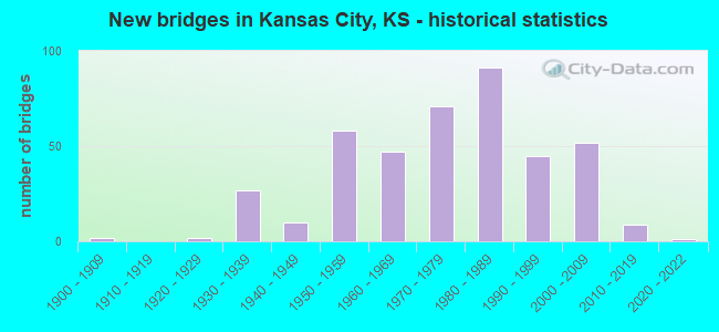
- New bridges - historical statistics
- 21900-1909
- 21920-1929
- 271930-1939
- 101940-1949
- 581950-1959
- 471960-1969
- 711970-1979
- 911980-1989
- 451990-1999
- 522000-2009
- 92010-2019
- 12020-2022
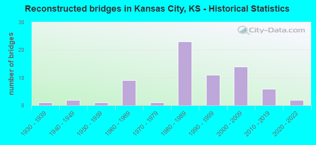
- Reconstructed bridges - Historical Statistics
- 11930-1939
- 21940-1949
- 11950-1959
- 91960-1969
- 11970-1979
- 231980-1989
- 111990-1999
- 142000-2009
- 62010-2019
- 22020-2022
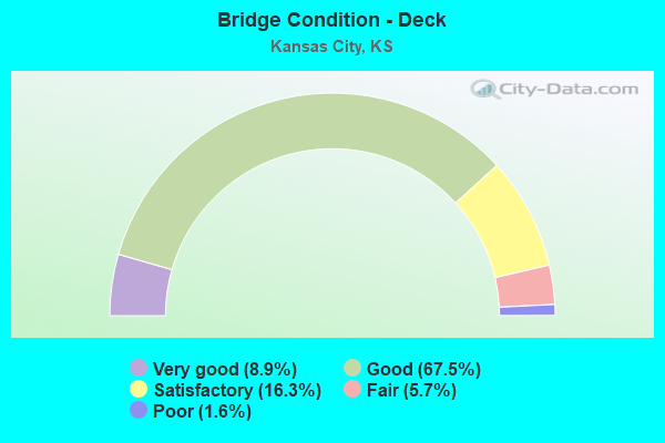
- Bridge Condition - Deck
- 8.9%Very good
- 67.5%Good
- 16.3%Satisfactory
- 5.7%Fair
- 1.6%Poor
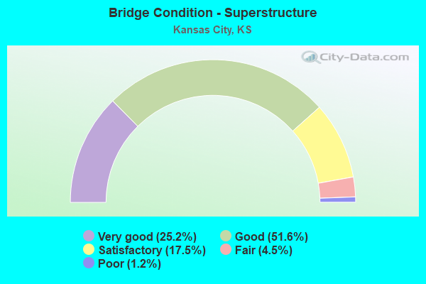
- Bridge Condition - Superstructure
- 25.2%Very good
- 51.6%Good
- 17.5%Satisfactory
- 4.5%Fair
- 1.2%Poor
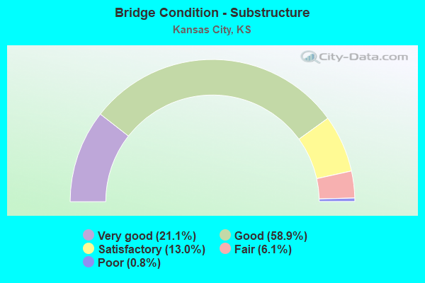
- Bridge Condition - Substructure
- 21.1%Very good
- 58.9%Good
- 13.0%Satisfactory
- 6.1%Fair
- 0.8%Poor
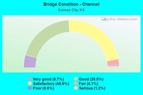
- Bridge Condition - Channel
- 8.7%Very good
- 39.5%Good
- 45.9%Satisfactory
- 4.1%Fair
- 0.6%Poor
- 1.2%Serious
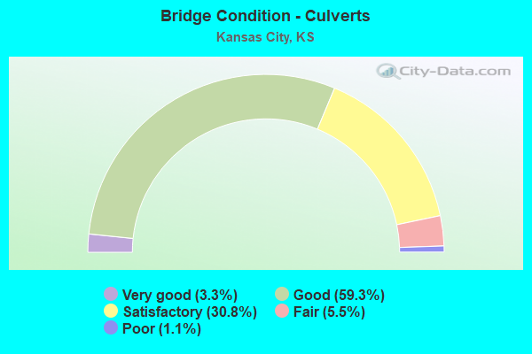
- Bridge Condition - Culverts
- 3.3%Very good
- 59.3%Good
- 30.8%Satisfactory
- 5.5%Fair
- 1.1%Poor
Find on map >> Show street view
Structure Number: 3701, Location: 3.6W 0.2N OF MADISON (Lat: 38.140111, Lng: -96.201694), Route carried "on" structure: County highway 150, Year Built: 1955, Status: Posted for load, Structure Length: 6.76m (22.18ft), Average Daily Traffic: 111 (year 2006), Truck Traffic: 10%, Average Future Daily Traffic: 230 (year 2043), Design Load: H 15, Features Intersected: BERNARD CREEK, Facility Carried by Structure: COUNTY RD. 365
Minimum Vertical Clearance: 30.47m (99.97ft), Kilometerpoint: 0.000, Lanes on structure: 2, Owner: County Highway Agency, Approaching Roadway Width: 7.3m (24.0ft), Material/Design: Steel continuous, Design/Construction: Stringer/Multi-beam, Number Of Spans In Main Unit: 3, Length of Maximum Span: 25.9m (85.0ft), Curb or Sidewalk Widths: Left: 0.4m (1.3ft), Right: 0.4m (1.3ft), Curb-To-Curb Width: 7.5m (24.6ft), Out-to-Out Width: 8.4m (27.6ft)
Condition: Deck: Satisfactory, Superstructure: Satisfactory, Substructure: Satisfactory, Channel: Satisfactory, Operating Rating: 35.9 metric tons, Method Used To Determine Operating Rating: Load Factor (LF), Inventory Rating: 21.5 metric tons, Method Used To Determine Inventory Rating: Load Factor (LF), Structural Evaluation: Equal to present minimum criteria, Deck Geometry: Somewhat better than minimum adequacy, Waterway Adequacy: Better than present minimum criteria, Approach Roadway Alignment: Somewhat better than minimum adequacy, Designated Inspection Frequency: Every 24 months, Inspection Date: June 2021, Deck Structure Type: Other, Wearing Surface/Protective System: Wearing Surface: Monolithic Concrete
Find on map >> Show street view
Structure Number: 3702, Location: 2.1N 1.5W OF EUREKA (Lat: 37.850361, Lng: -96.341167), Route carried "on" structure: County highway 290, Year Built: 1900, Year Reconstructed: 1935, Status: Posted for load, Structure Length: 1.33m (4.36ft), Average Daily Traffic: 122 (year 2006), Truck Traffic: 10%, Average Future Daily Traffic: 195 (year 2043), Features Intersected: TRIB. TO FALL RIVER
Minimum Vertical Clearance: 30.47m (99.97ft), Kilometerpoint: 0.000, Lanes on structure: 2, Owner: County Highway Agency, Approaching Roadway Width: 6.7m (22.0ft), Material/Design: Concrete, Design/Construction: Culvert, Number Of Spans In Main Unit: 2, Length of Maximum Span: 6.1m (20.0ft), Curb or Sidewalk Widths: Left: 0.5m (1.6ft), Right: 0.5m (1.6ft), Curb-To-Curb Width: 7.3m (24.0ft), Out-to-Out Width: 8.2m (26.9ft)
Condition: Channel: Serious, Culverts: Poor, Operating Rating: 22.1 metric tons, Method Used To Determine Operating Rating: Allowable Stress (AS), Inventory Rating: 22.1 metric tons, Method Used To Determine Inventory Rating: Allowable Stress (AS), Structural Evaluation: Meets minimum limits, Deck Geometry: Somewhat better than minimum adequacy, Waterway Adequacy: Equal to present minimum criteria, Approach Roadway Alignment: Somewhat better than minimum adequacy, Length Of Structure Improvement: 1.58m (5.18ft), Designated Inspection Frequency: Every 24 months, Inspection Date: June 2021, Bridge Improvement Cost: $85,000, Roadway Improvement Cost: $9,000, Total Project Cost: $128,000 ( Estimate for 2024), Wearing Surface/Protective System: Wearing Surface: Bituminous
Find on map >> Show street view
Structure Number: 3703, Location: 1.0N 2.4W OF VIRGIL (Lat: 37.997389, Lng: -96.036500), Route carried "on" structure: County highway 291, Year Built: 1934, Status: Posted for load, Structure Length: 1.03m (3.38ft), Average Daily Traffic: 166 (year 2006), Truck Traffic: 10%, Average Future Daily Traffic: 166 (year 2043), Design Load: HS 20, Features Intersected: TRIB. TO VERDIGRIS RIVER
Minimum Vertical Clearance: 30.47m (99.97ft), Kilometerpoint: 0.000, Lanes on structure: 2, Owner: County Highway Agency, Approaching Roadway Width: 7.3m (24.0ft), Material/Design: Concrete, Design/Construction: Culvert, Number Of Spans In Main Unit: 3, Length of Maximum Span: 3.0m (9.8ft), Curb or Sidewalk Widths: Left: 0.4m (1.3ft), Right: 0.4m (1.3ft), Curb-To-Curb Width: 8.5m (27.9ft), Out-to-Out Width: 9.3m (30.5ft)
Condition: Channel: Satisfactory, Culverts: Satisfactory, Operating Rating: 44.1 metric tons, Method Used To Determine Operating Rating: Load Factor (LF), Inventory Rating: 32.4 metric tons, Method Used To Determine Inventory Rating: Load Factor (LF), Structural Evaluation: Equal to present minimum criteria, Deck Geometry: Equal to present minimum criteria, Waterway Adequacy: Equal to present minimum criteria, Approach Roadway Alignment: Somewhat better than minimum adequacy, Designated Inspection Frequency: Every 24 months, Inspection Date: June 2021, Wearing Surface/Protective System: Wearing Surface: Bituminous
Find on map >> Show street view
Structure Number: 3704, Location: 1.3N OF HILLTOP (Lat: 38.075139, Lng: -96.039556), Route carried "on" structure: County highway 293, Year Built: 1932, Status: Posted for load, Structure Length: 2.29m (7.51ft), Average Daily Traffic: 67 (year 2006), Average Future Daily Traffic: 100 (year 2043), Features Intersected: TRIB. TO VERDIGRIS RIVER
Minimum Vertical Clearance: 30.47m (99.97ft), Kilometerpoint: 0.000, Lanes on structure: 2, Owner: County Highway Agency, Approaching Roadway Width: 6.0m (19.7ft), Material/Design: Concrete, Design/Construction: Tee Beam, Number Of Spans In Main Unit: 2, Length of Maximum Span: 11.3m (37.1ft), Curb or Sidewalk Widths: Left: 0.5m (1.6ft), Right: 0.5m (1.6ft), Curb-To-Curb Width: 6.1m (20.0ft), Out-to-Out Width: 7.0m (23.0ft)
Condition: Deck: Fair, Superstructure: Fair, Substructure: Fair, Channel: Satisfactory, Operating Rating: 19.6 metric tons, Method Used To Determine Operating Rating: Field evaluation and documented engineering judgment, Inventory Rating: 19.6 metric tons, Method Used To Determine Inventory Rating: Field evaluation and documented engineering judgment, Structural Evaluation: Somewhat better than minimum adequacy, Deck Geometry: Somewhat better than minimum adequacy, Waterway Adequacy: Better than present minimum criteria, Approach Roadway Alignment: Equal to present minimum criteria, Bridge Posting: Required (Relationship of Operating Rating to Maximum Legal Load: > 39.9% below), Designated Inspection Frequency: Every 24 months, Inspection Date: June 2021, Deck Structure Type: Other, Wearing Surface/Protective System: Wearing Surface: Gravel
Find on map >> Show street view
Structure Number: 3706, Location: 2.5N 0.7W OF FALL RIVER (Lat: 37.646861, Lng: -96.041861), Route carried "on" structure: County highway 1359, Year Built: 1936, Status: Posted for load, Structure Length: 0.70m (2.30ft), Average Daily Traffic: 136 (year 2006), Truck Traffic: 10%, Average Future Daily Traffic: 136 (year 2043), Design Load: HS 20, Features Intersected: TRIB. TO FALL RIVER
Minimum Vertical Clearance: 30.47m (99.97ft), Kilometerpoint: 0.000, Lanes on structure: 2, Owner: County Highway Agency, Approaching Roadway Width: 7.0m (23.0ft), Material/Design: Concrete, Design/Construction: Culvert, Number Of Spans In Main Unit: 2, Length of Maximum Span: 3.0m (9.8ft), Curb or Sidewalk Widths: Left: 0.4m (1.3ft), Right: 0.4m (1.3ft), Curb-To-Curb Width: 8.0m (26.2ft), Out-to-Out Width: 8.7m (28.5ft)
Condition: Channel: Satisfactory, Culverts: Satisfactory, Operating Rating: 44.1 metric tons, Method Used To Determine Operating Rating: Load Factor (LF), Inventory Rating: 32.4 metric tons, Method Used To Determine Inventory Rating: Load Factor (LF), Structural Evaluation: Equal to present minimum criteria, Deck Geometry: Somewhat better than minimum adequacy, Waterway Adequacy: Somewhat better than minimum adequacy, Approach Roadway Alignment: Equal to present desirable criteria, Designated Inspection Frequency: Every 24 months, Inspection Date: June 2021, Wearing Surface/Protective System: Wearing Surface: Gravel
Find on map >> Show street view
Structure Number: 3708, Location: 3.2N 0.7E OF VIRGIL (Lat: 38.029278, Lng: -95.995472), Route carried "on" structure: County highway 1399, Year Built: 1940, Status: Posted for load, Structure Length: 1.05m (3.44ft), Average Daily Traffic: 60 (year 2006), Average Future Daily Traffic: 85 (year 2043), Design Load: HS 20, Features Intersected: TRIB. TO VERDIGRIS RIVER
Minimum Vertical Clearance: 30.47m (99.97ft), Kilometerpoint: 0.000, Lanes on structure: 2, Owner: County Highway Agency, Approaching Roadway Width: 6.0m (19.7ft), Material/Design: Concrete continuous, Design/Construction: Slab, Number Of Spans In Main Unit: 3, Length of Maximum Span: 3.0m (9.8ft), Curb or Sidewalk Widths: Left: 0.3m (1.0ft), Right: 0.3m (1.0ft), Curb-To-Curb Width: 6.1m (20.0ft), Out-to-Out Width: 6.7m (22.0ft)
Condition: Deck: Satisfactory, Superstructure: Satisfactory, Substructure: Poor, Channel: Serious, Operating Rating: 44.1 metric tons, Method Used To Determine Operating Rating: Load Factor (LF), Inventory Rating: 32.4 metric tons, Method Used To Determine Inventory Rating: Load Factor (LF), Structural Evaluation: Meets minimum limits, Deck Geometry: Somewhat better than minimum adequacy, Waterway Adequacy: Somewhat better than minimum adequacy, Approach Roadway Alignment: Better than present minimum criteria, Designated Inspection Frequency: Every 24 months, Inspection Date: June 2021, Wearing Surface/Protective System: Wearing Surface: Gravel
Find on map >> Show street view
Structure Number: 49001, Location: 1.0S.W. OF BELVIDERE (Lat: 37.444353, Lng: -99.092111), Route carried "on" structure: County highway 32, Year Built: 1961, Status: Posted for load, Structure Length: 0.63m (2.07ft), Average Daily Traffic: 35 (year 2018), Truck Traffic: 5%, Average Future Daily Traffic: 40 (year 2040), Design Load: H 15, Features Intersected: TRIB. TO MEDICINE RIVER
Minimum Vertical Clearance: 30.47m (99.97ft), Kilometerpoint: 0.000, Lanes on structure: 2, Owner: County Highway Agency, Approaching Roadway Width: 7.3m (24.0ft), Material/Design: Concrete, Design/Construction: Culvert, Number Of Spans In Main Unit: 2, Length of Maximum Span: 3.0m (9.8ft), Curb-To-Curb Width: 8.5m (27.9ft), Out-to-Out Width: 9.1m (29.9ft)
Condition: Channel: Satisfactory, Culverts: Good, Operating Rating: 25.3 metric tons, Method Used To Determine Operating Rating: Load Factor (LF), Inventory Rating: 15.1 metric tons, Method Used To Determine Inventory Rating: Load Factor (LF), Structural Evaluation: Meets minimum limits, Deck Geometry: Better than present minimum criteria, Waterway Adequacy: Equal to present minimum criteria, Approach Roadway Alignment: Better than present minimum criteria, Bridge Posting: Required (Relationship of Operating Rating to Maximum Legal Load: 30.0 - 39.9% below), Designated Inspection Frequency: Every 24 months, Inspection Date: December 2020, Wearing Surface/Protective System: Wearing Surface: Bituminous
Find on map >> Show street view
Structure Number: 49002, Location: S.W. EDGE OF BELVIDERE (Lat: 37.448225, Lng: -99.083167), Route carried "on" structure: County highway 32, Year Built: 1961, Status: Posted for load, Structure Length: 0.61m (2.00ft), Average Daily Traffic: 35 (year 2018), Truck Traffic: 4%, Average Future Daily Traffic: 40 (year 2040), Design Load: H 15, Features Intersected: TRIB. TO MEDICINE RIVER
Minimum Vertical Clearance: 30.47m (99.97ft), Kilometerpoint: 0.000, Lanes on structure: 2, Owner: County Highway Agency, Approaching Roadway Width: 7.3m (24.0ft), Skew: 3 degrees, Material/Design: Concrete, Design/Construction: Culvert, Number Of Spans In Main Unit: 2, Length of Maximum Span: 3.2m (10.5ft), Curb or Sidewalk Widths: Left: 0.3m (1.0ft), Right: 0.3m (1.0ft), Curb-To-Curb Width: 8.8m (28.9ft), Out-to-Out Width: 9.4m (30.8ft)
Condition: Channel: Fair, Culverts: Satisfactory, Operating Rating: 20.1 metric tons, Method Used To Determine Operating Rating: Load Factor (LF), Inventory Rating: 12.0 metric tons, Method Used To Determine Inventory Rating: Load Factor (LF), Structural Evaluation: Meets minimum limits, Deck Geometry: Better than present minimum criteria, Waterway Adequacy: Equal to present minimum criteria, Approach Roadway Alignment: Equal to present minimum criteria, Bridge Posting: Required (Relationship of Operating Rating to Maximum Legal Load: 30.0 - 39.9% below), Designated Inspection Frequency: Every 24 months, Inspection Date: December 2020, Wearing Surface/Protective System: Wearing Surface: Bituminous
Find on map >> Show street view
Structure Number: 49003, Location: 1.0N.E. OF BELVIDERE (Lat: 37.456017, Lng: -99.065800), Route carried "on" structure: County highway 32, Year Built: 1958, Status: Posted for load, Structure Length: 7.80m (25.59ft), Average Daily Traffic: 65 (year 2018), Truck Traffic: 3%, Average Future Daily Traffic: 80 (year 2040), Design Load: H 15, Features Intersected: MEDICINE RIVER
Minimum Vertical Clearance: 30.47m (99.97ft), Kilometerpoint: 0.000, Lanes on structure: 2, Owner: County Highway Agency, Approaching Roadway Width: 7.9m (25.9ft), Material/Design: Concrete continuous, Design/Construction: Tee Beam, Number Of Spans In Main Unit: 5, Length of Maximum Span: 16.8m (55.1ft), Curb or Sidewalk Widths: Left: 0.3m (1.0ft), Right: 0.3m (1.0ft), Curb-To-Curb Width: 7.3m (24.0ft), Out-to-Out Width: 7.9m (25.9ft)
Condition: Deck: Good, Superstructure: Good, Substructure: Satisfactory, Channel: Satisfactory, Operating Rating: 20.1 metric tons, Method Used To Determine Operating Rating: Load Factor (LF), Inventory Rating: 12.1 metric tons, Method Used To Determine Inventory Rating: Load Factor (LF), Structural Evaluation: Meets minimum limits, Deck Geometry: Equal to present minimum criteria, Waterway Adequacy: Equal to present desirable criteria, Approach Roadway Alignment: Better than present minimum criteria, Bridge Posting: Required (Relationship of Operating Rating to Maximum Legal Load: > 39.9% below), Designated Inspection Frequency: Every 24 months, Inspection Date: December 2020, Deck Structure Type: Concrete Cast-file-Place, Wearing Surface/Protective System: Wearing Surface: Monolithic Concrete
Find on map >> Show street view
Structure Number: 49004, Location: 2.5S.E. OF BELVIDERE (Lat: 37.438167, Lng: -99.038286), Route carried "on" structure: County highway 32, Year Built: 1980, Status: Posted for load, Structure Length: 3.43m (11.25ft), Average Daily Traffic: 30 (year 2018), Truck Traffic: 5%, Average Future Daily Traffic: 35 (year 2040), Design Load: HS 20, Features Intersected: SOLDIERS CREEK
Minimum Vertical Clearance: 30.47m (99.97ft), Kilometerpoint: 0.000, Lanes on structure: 2, Owner: County Highway Agency, Approaching Roadway Width: 7.9m (25.9ft), Material/Design: Concrete continuous, Design/Construction: Slab, Number Of Spans In Main Unit: 3, Length of Maximum Span: 13.4m (44.0ft), Curb-To-Curb Width: 8.5m (27.9ft), Out-to-Out Width: 9.1m (29.9ft)
Condition: Deck: Good, Superstructure: Good, Substructure: Good, Channel: Satisfactory, Operating Rating: 42.3 metric tons, Method Used To Determine Operating Rating: Load Factor (LF), Inventory Rating: 25.3 metric tons, Method Used To Determine Inventory Rating: Load Factor (LF), Structural Evaluation: Equal to present minimum criteria, Deck Geometry: Better than present minimum criteria, Waterway Adequacy: Equal to present desirable criteria, Approach Roadway Alignment: Better than present minimum criteria, Bridge Posting: Required (Relationship of Operating Rating to Maximum Legal Load: 0.1 - 9.9% below), Designated Inspection Frequency: Every 24 months, Inspection Date: December 2020, Deck Structure Type: Concrete Cast-file-Place, Wearing Surface/Protective System: Wearing Surface: Monolithic Concrete
Find on map >> Show street view
Structure Number: 49005, Location: 3.0S.E. OF BELVIDERE (Lat: 37.436081, Lng: -99.029606), Route carried "on" structure: County highway 32, Year Built: 1980, Status: Posted for load, Structure Length: 1.17m (3.84ft), Average Daily Traffic: 30 (year 2018), Truck Traffic: 5%, Average Future Daily Traffic: 35 (year 2040), Design Load: HS 20, Features Intersected: TRIB. TO MEDICINE RIVER
Minimum Vertical Clearance: 30.47m (99.97ft), Kilometerpoint: 0.000, Lanes on structure: 2, Owner: County Highway Agency, Approaching Roadway Width: 8.2m (26.9ft), Material/Design: Concrete, Design/Construction: Culvert, Number Of Spans In Main Unit: 4, Length of Maximum Span: 2.7m (8.9ft), Curb or Sidewalk Widths: Left: 0.2m (0.7ft), Right: 0.2m (0.7ft), Curb-To-Curb Width: 9.1m (29.9ft), Out-to-Out Width: 10.1m (33.1ft)
Condition: Channel: Good, Culverts: Good, Operating Rating: 33.3 metric tons, Method Used To Determine Operating Rating: Load Factor (LF), Inventory Rating: 20.0 metric tons, Method Used To Determine Inventory Rating: Load Factor (LF), Structural Evaluation: Somewhat better than minimum adequacy, Deck Geometry: Better than present minimum criteria, Waterway Adequacy: Equal to present minimum criteria, Approach Roadway Alignment: Better than present minimum criteria, Bridge Posting: Required (Relationship of Operating Rating to Maximum Legal Load: 10.0 - 19.9% below), Designated Inspection Frequency: Every 24 months, Inspection Date: December 2020, Wearing Surface/Protective System: Wearing Surface: Gravel
Find on map >> Show street view
Structure Number: 49006, Location: 1.0N OF MULLINVILLE (Lat: 37.605200, Lng: -99.475894), Route carried "on" structure: County highway 218, Year Built: 1956, Status: Posted for load, Structure Length: 5.01m (16.44ft), Average Daily Traffic: 190 (year 2018), Truck Traffic: 5%, Average Future Daily Traffic: 230 (year 2040), Design Load: H 15, Features Intersected: W. FORK RATTLESNAKE CK.
Minimum Vertical Clearance: 30.47m (99.97ft), Kilometerpoint: 0.000, Lanes on structure: 2, Owner: County Highway Agency, Approaching Roadway Width: 7.3m (24.0ft), Material/Design: Concrete continuous, Design/Construction: Slab, Number Of Spans In Main Unit: 4, Length of Maximum Span: 13.7m (44.9ft), Curb or Sidewalk Widths: Left: 0.8m (2.6ft), Right: 0.8m (2.6ft), Curb-To-Curb Width: 7.3m (24.0ft), Out-to-Out Width: 9.0m (29.5ft)
Condition: Deck: Good, Superstructure: Good, Substructure: Good, Channel: Satisfactory, Operating Rating: 14.6 metric tons, Method Used To Determine Operating Rating: Load Factor (LF), Inventory Rating: 8.7 metric tons, Method Used To Determine Inventory Rating: Load Factor (LF), Structural Evaluation: High priority of replacement, Deck Geometry: Somewhat better than minimum adequacy, Waterway Adequacy: Equal to present minimum criteria, Approach Roadway Alignment: Better than present minimum criteria, Bridge Posting: Required (Relationship of Operating Rating to Maximum Legal Load: > 39.9% below), Length Of Structure Improvement: 5.49m (18.01ft), Designated Inspection Frequency: Every 24 months, Inspection Date: December 2020, Bridge Improvement Cost: $530,000, Roadway Improvement Cost: $190,000, Total Project Cost: $720,000 ( Estimate for 2020), Deck Structure Type: Concrete Cast-file-Place
Find on map >> Show street view
Structure Number: 49007, Location: 7.5N OF BRENHAM (Lat: 37.715764, Lng: -99.178036), Route carried "on" structure: County highway 222, Year Built: 1982, Status: Open, Structure Length: 7.19m (23.59ft), Average Daily Traffic: 15 (year 2018), Truck Traffic: 5%, Average Future Daily Traffic: 20 (year 2040), Design Load: HS 20, Features Intersected: RATTLESNAKE CREEK
Minimum Vertical Clearance: 30.47m (99.97ft), Kilometerpoint: 0.000, Lanes on structure: 2, Owner: County Highway Agency, Approaching Roadway Width: 7.9m (25.9ft), Material/Design: Concrete continuous, Design/Construction: Slab, Number Of Spans In Main Unit: 5, Length of Maximum Span: 15.8m (51.8ft), Curb-To-Curb Width: 8.5m (27.9ft), Out-to-Out Width: 9.1m (29.9ft)
Condition: Deck: Good, Superstructure: Good, Substructure: Good, Channel: Satisfactory, Operating Rating: 37.5 metric tons, Method Used To Determine Operating Rating: Load Factor (LF), Inventory Rating: 22.4 metric tons, Method Used To Determine Inventory Rating: Load Factor (LF), Structural Evaluation: Equal to present minimum criteria, Deck Geometry: Better than present minimum criteria, Waterway Adequacy: Equal to present minimum criteria, Approach Roadway Alignment: Better than present minimum criteria, Designated Inspection Frequency: Every 24 months, Inspection Date: December 2020, Other Special Inspection Date: December 2020, Deck Structure Type: Concrete Cast-file-Place, Wearing Surface/Protective System: Wearing Surface: Gravel
Find on map >> Show street view
Structure Number: 50003, Location: 2.8S OF VALEDA (Lat: 37.008647, Lng: -95.449844), Route carried "on" structure: County highway 368, Year Built: 1930, Status: Posted for load, Structure Length: 0.63m (2.07ft), Average Daily Traffic: 160 (year 2013), Average Future Daily Traffic: 192 (year 2041), Features Intersected: TRIB. TO SNOW CREEK
Minimum Vertical Clearance: 30.47m (99.97ft), Kilometerpoint: 0.000, Lanes on structure: 2, Owner: County Highway Agency, Approaching Roadway Width: 7.1m (23.3ft), Material/Design: Concrete, Design/Construction: Culvert, Number Of Spans In Main Unit: 2, Length of Maximum Span: 3.0m (9.8ft), Curb-To-Curb Width: 7.1m (23.3ft), Out-to-Out Width: 7.9m (25.9ft)
Condition: Channel: Fair, Culverts: Satisfactory, Operating Rating: 40.5 metric tons, Method Used To Determine Operating Rating: Field evaluation and documented engineering judgment, Inventory Rating: 24.3 metric tons, Method Used To Determine Inventory Rating: Field evaluation and documented engineering judgment, Structural Evaluation: Equal to present minimum criteria, Deck Geometry: Meets minimum limits, Waterway Adequacy: Somewhat better than minimum adequacy, Approach Roadway Alignment: Equal to present desirable criteria, Bridge Posting: Required (Relationship of Operating Rating to Maximum Legal Load: > 39.9% below), Designated Inspection Frequency: Every 24 months, Inspection Date: November 2021
Find on map >> Show street view
Structure Number: 50004, Location: 1.9S OF VALEDA (Lat: 37.020353, Lng: -95.450019), Route carried "on" structure: County highway 368, Year Built: 1930, Status: Posted for load, Structure Length: 0.63m (2.07ft), Average Daily Traffic: 160 (year 2013), Average Future Daily Traffic: 192 (year 2041), Features Intersected: TRIB. TO SNOW CREEK
Minimum Vertical Clearance: 30.47m (99.97ft), Kilometerpoint: 0.000, Lanes on structure: 2, Owner: County Highway Agency, Approaching Roadway Width: 7.1m (23.3ft), Material/Design: Concrete, Design/Construction: Culvert, Number Of Spans In Main Unit: 2, Length of Maximum Span: 3.0m (9.8ft), Curb-To-Curb Width: 7.1m (23.3ft), Out-to-Out Width: 7.9m (25.9ft)
Condition: Channel: Satisfactory, Culverts: Satisfactory, Operating Rating: 13.6 metric tons, Method Used To Determine Operating Rating: Field evaluation and documented engineering judgment, Inventory Rating: 13.6 metric tons, Method Used To Determine Inventory Rating: Field evaluation and documented engineering judgment, Structural Evaluation: Meets minimum limits, Deck Geometry: Meets minimum limits, Waterway Adequacy: Somewhat better than minimum adequacy, Approach Roadway Alignment: Equal to present desirable criteria, Bridge Posting: Required (Relationship of Operating Rating to Maximum Legal Load: > 39.9% below), Designated Inspection Frequency: Every 24 months, Inspection Date: November 2021
Find on map >> Show street view
Structure Number: 5008, Location: 0.75E 1.1S OF PARSONS (Lat: 37.325653, Lng: -95.235367), Route carried "on" structure: County highway 1948, Year Built: 1970, Status: Posted for load, Structure Length: 8.90m (29.20ft), Average Daily Traffic: 415 (year 2013), Average Future Daily Traffic: 498 (year 2041), Design Load: H 15, Features Intersected: LABETTE CREEK
Minimum Vertical Clearance: 30.47m (99.97ft), Kilometerpoint: 0.000, Lanes on structure: 2, Owner: County Highway Agency, Approaching Roadway Width: 7.5m (24.6ft), Material/Design: Steel continuous, Design/Construction: Stringer/Multi-beam, Number Of Spans In Main Unit: 4, Length of Maximum Span: 24.4m (80.1ft), Curb-To-Curb Width: 8.5m (27.9ft), Out-to-Out Width: 9.4m (30.8ft)
Condition: Deck: Very good, Superstructure: Good, Substructure: Very good, Channel: Satisfactory, Operating Rating: 29.5 metric tons, Method Used To Determine Operating Rating: Load and Resistance Factor (LRFR), Inventory Rating: 21.6 metric tons, Method Used To Determine Inventory Rating: Load and Resistance Factor (LRFR), Structural Evaluation: Equal to present minimum criteria, Deck Geometry: Somewhat better than minimum adequacy, Waterway Adequacy: Equal to present desirable criteria, Approach Roadway Alignment: Equal to present desirable criteria, Designated Inspection Frequency: Every 24 months, Inspection Date: August 2021, Deck Structure Type: Concrete Cast-file-Place
Find on map >> Show street view
Structure Number: 5101, Location: 12.0S OF ALAMOTA (Lat: 38.283233, Lng: -100.299233), Route carried "on" structure: County highway 380, Year Built: 1958, Status: Posted for load, Structure Length: 4.80m (15.75ft), Average Daily Traffic: 15 (year 2015), Average Future Daily Traffic: 20 (year 2041), Design Load: H 15, Features Intersected: HACKBERRY CREEK
Minimum Vertical Clearance: 30.47m (99.97ft), Kilometerpoint: 2.253, Lanes on structure: 2, Owner: County Highway Agency, Approaching Roadway Width: 7.3m (24.0ft), Material/Design: Concrete continuous, Design/Construction: Tee Beam, Number Of Spans In Main Unit: 3, Length of Maximum Span: 19.2m (63.0ft), Curb or Sidewalk Widths: Left: 0.4m (1.3ft), Right: 0.4m (1.3ft), Curb-To-Curb Width: 7.3m (24.0ft), Out-to-Out Width: 8.1m (26.6ft)
Condition: Deck: Satisfactory, Superstructure: Satisfactory, Substructure: Good, Channel: Satisfactory, Operating Rating: 22.2 metric tons, Method Used To Determine Operating Rating: Load Factor (LF), Inventory Rating: 13.2 metric tons, Method Used To Determine Inventory Rating: Load Factor (LF), Structural Evaluation: Meets minimum limits, Deck Geometry: Equal to present minimum criteria, Waterway Adequacy: Better than present minimum criteria, Approach Roadway Alignment: Better than present minimum criteria, Bridge Posting: Required (Relationship of Operating Rating to Maximum Legal Load: 30.0 - 39.9% below), Designated Inspection Frequency: Every 24 months, Inspection Date: November 2021, Deck Structure Type: Concrete Cast-file-Place, Wearing Surface/Protective System: Wearing Surface: Monolithic Concrete
Find on map >> Show street view
Structure Number: 9601, Location: 1.9W OF ADAMSVILLE (Lat: 37.173094, Lng: -97.200125), Route carried "on" structure: County highway 162, Year Built: 1961, Status: Posted for load, Structure Length: 10.76m (35.30ft), Average Daily Traffic: 43 (year 2013), Truck Traffic: 1%, Average Future Daily Traffic: 144 (year 2041), Design Load: H 15, Features Intersected: SLATE CREEK
Minimum Vertical Clearance: 30.47m (99.97ft), Kilometerpoint: 0.000, Lanes on structure: 2, Owner: County Highway Agency, Approaching Roadway Width: 9.1m (29.9ft), Material/Design: Steel continuous, Design/Construction: Stringer/Multi-beam, Number Of Spans In Main Unit: 4, Length of Maximum Span: 33.5m (109.9ft), Curb-To-Curb Width: 7.9m (25.9ft), Out-to-Out Width: 8.5m (27.9ft)
Condition: Deck: Satisfactory, Superstructure: Good, Substructure: Satisfactory, Channel: Satisfactory, Operating Rating: 29.2 metric tons, Method Used To Determine Operating Rating: Load Factor (LF), Inventory Rating: 17.5 metric tons, Method Used To Determine Inventory Rating: Load Factor (LF), Structural Evaluation: Somewhat better than minimum adequacy, Deck Geometry: Equal to present minimum criteria, Waterway Adequacy: Equal to present desirable criteria, Approach Roadway Alignment: Equal to present minimum criteria, Length Of Structure Improvement: 11.28m (37.01ft), Designated Inspection Frequency: Every 24 months, Inspection Date: May 2021, Bridge Improvement Cost: $990,000, Roadway Improvement Cost: $120,000, Total Project Cost: $1,000,000 ( Estimate for 2019), Deck Structure Type: Concrete Cast-file-Place
Find on map >> Show street view
Structure Number: 414301052524073, Location: 4450 PARALLEL PARKWAY (Lat: 39.128522, Lng: -94.682633), Route carried "on" structure: City street 2524, Year Built: 1975, Status: Open, Structure Length: 4.74m (15.55ft), Average Daily Traffic: 18,600 (year 2007), Truck Traffic: 8%, Average Future Daily Traffic: 34,500 (year 2043), Design Load: HS 20, Features Intersected: VICTORY DRIVE, Facility Carried by Structure: PARALLELPARKWAY
Minimum Vertical Clearance: 30.47m (99.97ft), Kilometerpoint: 0.000, Lanes on structure: 5, Lanes under structure: 1, Owner: County Highway Agency, Approaching Roadway Width: 16.4m (53.8ft), Skew: 34 degrees, Material/Design: Concrete continuous, Design/Construction: Slab, Number Of Spans In Main Unit: 3, Length of Maximum Span: 18.0m (59.1ft), Curb or Sidewalk Widths: Left: 0.5m (1.6ft), Right: 0.5m (1.6ft), Curb-To-Curb Width: 17.1m (56.1ft), Out-to-Out Width: 23.5m (77.1ft)
Condition: Deck: Satisfactory, Superstructure: Satisfactory, Substructure: Very good, Operating Rating: 43.5 metric tons, Method Used To Determine Operating Rating: Allowable Stress (AS), Inventory Rating: 32.7 metric tons, Method Used To Determine Inventory Rating: Allowable Stress (AS), Structural Evaluation: Equal to present minimum criteria, Deck Geometry: High priority of replacement, Underclear: Meets minimum limits, Approach Roadway Alignment: Equal to present desirable criteria, Length Of Structure Improvement: 4.85m (15.91ft), Designated Inspection Frequency: Every 24 months, Inspection Date: March 2021, Bridge Improvement Cost: $8,000, Roadway Improvement Cost: $2,000, Total Project Cost: $12,000, Deck Structure Type: Concrete Cast-file-Place, Wearing Surface/Protective System: Wearing Surface: Low Slump Concrete
Find on map >> Show street view
Structure Number: 414301052535082, Location: WOLCOTT DR. S. OF HUTTON (Lat: 39.186903, Lng: -94.799253), Route carried "on" structure: City street 2535, Year Built: 1973, Status: Open, Structure Length: 3.51m (11.52ft), Average Daily Traffic: 1,322 (year 1992), Truck Traffic: 5%, Average Future Daily Traffic: 1,500 (year 2043), Design Load: H 20, Features Intersected: CONNOR CREEK, Facility Carried by Structure: WOLCOTT DRIVE
Minimum Vertical Clearance: 30.47m (99.97ft), Kilometerpoint: 0.000, Lanes on structure: 2, Owner: County Highway Agency, Approaching Roadway Width: 7.3m (24.0ft), Skew: 3 degrees, Material/Design: Prestressed concrete continuous, Design/Construction: Tee Beam, Number Of Spans In Main Unit: 3, Length of Maximum Span: 11.6m (38.1ft), Curb-To-Curb Width: 8.6m (28.2ft), Out-to-Out Width: 9.2m (30.2ft)
Condition: Deck: Poor, Superstructure: Satisfactory, Substructure: Satisfactory, Channel: Satisfactory, Operating Rating: 59.1 metric tons, Method Used To Determine Operating Rating: Load Factor (LF), Inventory Rating: 33.2 metric tons, Method Used To Determine Inventory Rating: Load Factor (LF), Structural Evaluation: Equal to present minimum criteria, Deck Geometry: Somewhat better than minimum adequacy, Waterway Adequacy: Better than present minimum criteria, Approach Roadway Alignment: Equal to present desirable criteria, Length Of Structure Improvement: 6.10m (20.01ft), Designated Inspection Frequency: Every 24 months, Inspection Date: March 2021, Other Special Inspection Date: Febuary 2019, Total Project Cost: $1,000 ( Estimate for 2015), Deck Structure Type: Concrete Cast-file-Place
Find on map >> Show street view
Structure Number: 414301052550076, Location: MINNESOTA AVE. FAIRFAX (Lat: 39.115972, Lng: -94.614222), Route carried "on" structure: City street 2550, Year Built: 1939, Year Reconstructed: 1989, Status: Open, Structure Length: 21.85m (71.69ft), Average Daily Traffic: 14,490 (year 2013), Truck Traffic: 40%, Average Future Daily Traffic: 16,000 (year 2043), Design Load: HS 20, Features Intersected: RAILROAD YARD, Facility Carried by Structure: MINN AVE
Minimum Vertical Clearance: 5.33m (17.49ft), Kilometerpoint: 0.000, Lanes on structure: 2, Owner: County Highway Agency, Approaching Roadway Width: 15.5m (50.9ft), Material/Design: Steel, Design/Construction: Stringer/Multi-beam, Number Of Spans In Main Unit: 15, Length of Maximum Span: 18.6m (61.0ft), Curb or Sidewalk Widths: Left: 3.7m (12.1ft), Right: 0.0m, Curb-To-Curb Width: 13.1m (43.0ft), Out-to-Out Width: 17.8m (58.4ft)
Condition: Deck: Good, Superstructure: Good, Substructure: Satisfactory, Operating Rating: 73.6 metric tons, Method Used To Determine Operating Rating: Load Factor (LF), Inventory Rating: 44.1 metric tons, Method Used To Determine Inventory Rating: Load Factor (LF), Structural Evaluation: Equal to present minimum criteria, Deck Geometry: Somewhat better than minimum adequacy, Underclear: Somewhat better than minimum adequacy, Approach Roadway Alignment: Better than present minimum criteria, Length Of Structure Improvement: 21.95m (72.01ft), Designated Inspection Frequency: Every 24 months, Inspection Date: August 2021, Bridge Improvement Cost: $9,000, Roadway Improvement Cost: $1,000, Total Project Cost: $12,000, Deck Structure Type: Concrete Cast-file-Place, Wearing Surface/Protective System: Deck Protection: Epoxy Coated Reinforcing
Find on map >> Show street view
Structure Number: 414301052560002, Location: JAMES ST. OVER KS. RIVER (Lat: 39.111447, Lng: -94.616503), Route carried "on" structure: City street 2560, Year Built: 1987, Status: Open, Structure Length: 27.13m (89.01ft), Average Daily Traffic: 4,900 (year 2013), Truck Traffic: 60%, Average Future Daily Traffic: 9,800 (year 2043), Design Load: HS 20, Features Intersected: KANSAS RIVER, R.R. YARD, Facility Carried by Structure: JAMES STREET
Minimum Vertical Clearance: 30.47m (99.97ft), Kilometerpoint: 0.000, Lanes on structure: 2, Owner: County Highway Agency, Approaching Roadway Width: 14.6m (47.9ft), Skew: 10 degrees, Navigation Control: Yes ( Vertical Clearance: 12.1m (39.7ft), Horizontal Clearance: 72.8m (238.8ft)), Material/Design: Steel continuous, Design/Construction: Stringer/Multi-beam, Number Of Spans In Main Unit: 3, Number Of Approach Spans: 3, Length of Maximum Span: 87.8m (288.1ft), Curb-To-Curb Width: 9.8m (32.2ft), Out-to-Out Width: 10.4m (34.1ft)
Condition: Deck: Good, Superstructure: Very good, Substructure: Fair, Channel: Satisfactory, Operating Rating: 58.9 metric tons, Method Used To Determine Operating Rating: Load Factor (LF), Inventory Rating: 34.5 metric tons, Method Used To Determine Inventory Rating: Load Factor (LF), Structural Evaluation: Somewhat better than minimum adequacy, Deck Geometry: Meets minimum limits, Underclear: Somewhat better than minimum adequacy, Waterway Adequacy: Better than present minimum criteria, Approach Roadway Alignment: Equal to present minimum criteria, Designated Inspection Frequency: Every 24 months, Underwater Inspection Frequency: Every 60 months, Inspection Date: March 2021, Underwater Inspection Date: October 2021, Deck Structure Type: Concrete Cast-file-Place, Wearing Surface/Protective System: Wearing Surface: Monolithic Concrete, Deck Protection: Epoxy Coated Reinforcing
Find on map >> Show street view
Structure Number: 414301052600057, Location: E KS AVE OVER KS RIVER (Lat: 39.090053, Lng: -94.608672), Route carried "on" structure: City street 2600, Year Built: 1921, Year Reconstructed: 2002, Status: Open, Structure Length: 42.52m (139.50ft), Average Daily Traffic: 7,065 (year 2013), Truck Traffic: 10%, Average Future Daily Traffic: 10,600 (year 2043), Design Load: HS 20, Features Intersected: KANSAS RIVER, Facility Carried by Structure: KANSAS AVENUE
Minimum Vertical Clearance: 30.47m (99.97ft), Kilometerpoint: 0.000, Lanes on structure: 4, Lanes under structure: 4, Owner: County Highway Agency, Approaching Roadway Width: 18.2m (59.7ft), Skew: 31 degrees, Navigation Control: Yes ( Vertical Clearance: 4.5m (14.8ft), Horizontal Clearance: 91.4m (299.9ft)), Material/Design: Steel continuous, Design/Construction: Truss - Deck, Number Of Spans In Main Unit: 3, Number Of Approach Spans: 17, Length of Maximum Span: 98.1m (321.9ft), Curb or Sidewalk Widths: Left: 0.0m, Right: 1.6m (5.2ft), Curb-To-Curb Width: 15.2m (49.9ft), Out-to-Out Width: 17.9m (58.7ft)
Condition: Deck: Satisfactory, Superstructure: Fair, Substructure: Fair, Channel: Fair, Operating Rating: 26.3 metric tons, Method Used To Determine Operating Rating: Load Factor (LF), Inventory Rating: 15.4 metric tons, Method Used To Determine Inventory Rating: Load Factor (LF), Structural Evaluation: High priority of replacement, Deck Geometry: High priority of corrective action, Underclear: Meets minimum limits, Waterway Adequacy: Better than present minimum criteria, Approach Roadway Alignment: Equal to present minimum criteria, Bridge Posting: Required (Relationship of Operating Rating to Maximum Legal Load: > 39.9% below), Designated Inspection Frequency: Every 24 months, Critical Feature Inspection Frequency: Every 12 months, Underwater Inspection Frequency: Every 60 months, Inspection Date: December 2021, Critical Feature Inspection Date: July 2021, Underwater Inspection Date: October 2021, Other Special Inspection Date: December 2021, Bridge Improvement Cost: $16,000, Roadway Improvement Cost: $2,000, Total Project Cost: $26,000 ( Estimate for 2015), Deck Structure Type: Concrete Cast-file-Place
Find on map >> Show street view
Structure Number: 41430105260049C, Location: 3RD. ST. RAMP-CENTRAL AVE (Lat: 39.101389, Lng: -94.617222), Route carried "on" structure: City street 2574, Year Built: 1990, Status: Open, Structure Length: 18.56m (60.89ft), Average Daily Traffic: 2,000 (year 2013), Truck Traffic: 80%, Average Future Daily Traffic: 2,500 (year 2043), Design Load: HS 20, Features Intersected: KANSAS RIVER, Facility Carried by Structure: CENTRAL AVE.
Minimum Vertical Clearance: 30.47m (99.97ft), Kilometerpoint: 0.000, Lanes on structure: 2, Lanes under structure: 2, Owner: County Highway Agency, Approaching Roadway Width: 7.9m (25.9ft), Material/Design: Steel continuous, Design/Construction: Stringer/Multi-beam, Number Of Spans In Main Unit: 10, Length of Maximum Span: 21.3m (69.9ft), Curb-To-Curb Width: 7.8m (25.6ft), Out-to-Out Width: 8.6m (28.2ft)
Condition: Deck: Good, Superstructure: Good, Substructure: Good, Operating Rating: 54.0 metric tons, Method Used To Determine Operating Rating: Load Factor (LF), Inventory Rating: 32.3 metric tons, Method Used To Determine Inventory Rating: Load Factor (LF), Structural Evaluation: Better than present minimum criteria, Deck Geometry: Meets minimum limits, Underclear: Somewhat better than minimum adequacy, Approach Roadway Alignment: Meets minimum limits, Designated Inspection Frequency: Every 24 months, Inspection Date: March 2021, Deck Structure Type: Concrete Cast-file-Place, Wearing Surface/Protective System: Wearing Surface: Low Slump Concrete
Find on map >> Show street view
Structure Number: 414301052624174, Location: 5800 METROPOLITAN (Lat: 39.073133, Lng: -94.713347), Route carried "on" structure: City street 2624, Year Built: 1935, Year Reconstructed: 1988, Status: Open, Structure Length: 0.61m (2.00ft), Average Daily Traffic: 1,800 (year 2007), Truck Traffic: 10%, Average Future Daily Traffic: 3,000 (year 2043), Design Load: HS 20, Features Intersected: STREAM, Facility Carried by Structure: METROPOLITAN
Minimum Vertical Clearance: 30.47m (99.97ft), Kilometerpoint: 0.000, Lanes on structure: 2, Owner: County Highway Agency, Approaching Roadway Width: 7.6m (24.9ft), Skew: 2 degrees, Material/Design: Concrete, Design/Construction: Culvert, Number Of Spans In Main Unit: 2, Length of Maximum Span: 2.9m (9.5ft)
Condition: Channel: Satisfactory, Culverts: Good, Operating Rating: 86.3 metric tons, Method Used To Determine Operating Rating: Load Factor (LF), Inventory Rating: 51.6 metric tons, Method Used To Determine Inventory Rating: Load Factor (LF), Structural Evaluation: Better than present minimum criteria, Waterway Adequacy: Equal to present minimum criteria, Approach Roadway Alignment: Equal to present desirable criteria, Designated Inspection Frequency: Every 24 months, Inspection Date: March 2021, Other Special Inspection Date: November 2020
Find on map >> Show street view
Structure Number: 414301052825198, Location: 59TH ST S OF METROPOLITAN (Lat: 39.072008, Lng: -94.714550), Route carried "on" structure: City street 2825, Year Built: 1970, Status: Open, Structure Length: 0.63m (2.07ft), Average Daily Traffic: 3,850 (year 2013), Truck Traffic: 25%, Average Future Daily Traffic: 6,700 (year 2043), Design Load: HS 20, Features Intersected: STREAM, Facility Carried by Structure: 59TH STREET
Minimum Vertical Clearance: 30.47m (99.97ft), Kilometerpoint: 0.000, Lanes on structure: 2, Owner: County Highway Agency, Approaching Roadway Width: 8.2m (26.9ft), Material/Design: Concrete, Design/Construction: Culvert, Number Of Spans In Main Unit: 2, Length of Maximum Span: 3.0m (9.8ft)
Condition: Channel: Satisfactory, Culverts: Satisfactory, Operating Rating: 58.1 metric tons, Method Used To Determine Operating Rating: Allowable Stress (AS), Inventory Rating: 32.7 metric tons, Method Used To Determine Inventory Rating: Allowable Stress (AS), Structural Evaluation: Equal to present minimum criteria, Waterway Adequacy: Better than present minimum criteria, Approach Roadway Alignment: Equal to present desirable criteria, Designated Inspection Frequency: Every 24 months, Inspection Date: March 2021
Find on map >> Show street view
Structure Number: 414301052825207, Location: INLAND DR E OF 59TH ST (Lat: 39.084117, Lng: -94.713000), Route carried "on" structure: City street 2825, Year Built: 1950, Status: Open, Structure Length: 0.94m (3.08ft), Average Daily Traffic: 4,680 (year 2013), Truck Traffic: 40%, Average Future Daily Traffic: 9,360 (year 2043), Design Load: HS 20, Features Intersected: STREAM, Facility Carried by Structure: INLAND DRIVE
Minimum Vertical Clearance: 30.47m (99.97ft), Kilometerpoint: 0.000, Lanes on structure: 2, Owner: County Highway Agency, Approaching Roadway Width: 8.5m (27.9ft), Material/Design: Concrete, Design/Construction: Culvert, Number Of Spans In Main Unit: 2, Length of Maximum Span: 4.6m (15.1ft)
Condition: Channel: Satisfactory, Culverts: Satisfactory, Operating Rating: 40.8 metric tons, Method Used To Determine Operating Rating: Allowable Stress (AS), Inventory Rating: 32.7 metric tons, Method Used To Determine Inventory Rating: Allowable Stress (AS), Structural Evaluation: Equal to present minimum criteria, Waterway Adequacy: Equal to present minimum criteria, Approach Roadway Alignment: Equal to present desirable criteria, Designated Inspection Frequency: Every 24 months, Inspection Date: March 2021
Find on map >> Show street view
Structure Number: 414301052835032, Location: 57TH. N. OF TAUROMEE (Lat: 39.109692, Lng: -94.709789), Route carried "on" structure: City street 2835, Year Built: 1981, Status: Open, Structure Length: 0.88m (2.89ft), Average Daily Traffic: 10,285 (year 2013), Truck Traffic: 5%, Average Future Daily Traffic: 18,000 (year 2043), Design Load: H 20, Features Intersected: BRENNER HEIGHTS CREEK, Facility Carried by Structure: 57TH. STREET
Minimum Vertical Clearance: 30.47m (99.97ft), Kilometerpoint: 0.000, Lanes on structure: 4, Owner: County Highway Agency, Approaching Roadway Width: 15.8m (51.8ft), Skew: 3 degrees, Material/Design: Concrete, Design/Construction: Culvert, Number Of Spans In Main Unit: 2, Length of Maximum Span: 4.2m (13.8ft), Curb or Sidewalk Widths: Left: 1.2m (3.9ft), Right: 1.2m (3.9ft)
Condition: Channel: Satisfactory, Culverts: Good, Inventory Rating: 24.2 metric tons, Method Used To Determine Inventory Rating: Load Factor (LF), Structural Evaluation: Somewhat better than minimum adequacy, Waterway Adequacy: Equal to present minimum criteria, Approach Roadway Alignment: Equal to present desirable criteria, Designated Inspection Frequency: Every 24 months, Inspection Date: March 2021, Other Special Inspection Date: Febuary 2019
Find on map >> Show street view
Structure Number: 414301052865136, Location: SW BLVD. W. OF MISSION (Lat: 39.058694, Lng: -94.625944), Route carried "on" structure: City street 2865, Year Built: 1996, Status: Open, Structure Length: 3.35m (10.99ft), Average Daily Traffic: 7,720 (year 2013), Truck Traffic: 6%, Average Future Daily Traffic: 10,800 (year 2043), Design Load: HS 20, Features Intersected: TURKEY CREEK, Facility Carried by Structure: SOUTHWEST BLVD
Minimum Vertical Clearance: 6.40m (21.00ft), Kilometerpoint: 0.000, Lanes on structure: 2, Owner: County Highway Agency, Approaching Roadway Width: 14.6m (47.9ft), Material/Design: Steel continuous, Design/Construction: Stringer/Multi-beam, Number Of Spans In Main Unit: 2, Length of Maximum Span: 16.8m (55.1ft), Curb or Sidewalk Widths: Left: 1.5m (4.9ft), Right: 1.5m (4.9ft), Curb-To-Curb Width: 14.6m (47.9ft), Out-to-Out Width: 18.9m (62.0ft)
Condition: Deck: Good, Superstructure: Very good, Substructure: Good, Channel: Good, Operating Rating: 49.8 metric tons, Method Used To Determine Operating Rating: Load Factor (LF), Inventory Rating: 29.8 metric tons, Method Used To Determine Inventory Rating: Load Factor (LF), Structural Evaluation: Better than present minimum criteria, Deck Geometry: Superior to present desirable criteria, Waterway Adequacy: Somewhat better than minimum adequacy, Approach Roadway Alignment: Equal to present desirable criteria, Designated Inspection Frequency: Every 24 months, Inspection Date: March 2021, Deck Structure Type: Concrete Cast-file-Place, Wearing Surface/Protective System: Deck Protection: Epoxy Coated Reinforcing
Find on map >> Show street view
Structure Number: 414301052865258, Location: MISSION RD OVER SW BLVD (Lat: 39.058700, Lng: -94.623894), Route carried "on" structure: City street 2865, Year Built: 1965, Year Reconstructed: 2005, Status: Open, Structure Length: 7.41m (24.31ft), Average Daily Traffic: 17,850 (year 2013), Truck Traffic: 15%, Average Future Daily Traffic: 26,800 (year 2043), Design Load: HS 20, Features Intersected: SOUTHWEST BOULEVARD, Facility Carried by Structure: MISSION ROAD
Minimum Vertical Clearance: 30.47m (99.97ft), Kilometerpoint: 0.000, Lanes on structure: 4, Lanes under structure: 4, Owner: County Highway Agency, Approaching Roadway Width: 17.0m (55.8ft), Skew: 30 degrees, Material/Design: Steel continuous, Design/Construction: Stringer/Multi-beam, Number Of Spans In Main Unit: 3, Length of Maximum Span: 32.3m (106.0ft), Curb-To-Curb Width: 17.1m (56.1ft), Out-to-Out Width: 18.9m (62.0ft)
Condition: Deck: Good, Superstructure: Very good, Substructure: Good, Operating Rating: 58.2 metric tons, Method Used To Determine Operating Rating: Load Factor (LF), Inventory Rating: 34.8 metric tons, Method Used To Determine Inventory Rating: Load Factor (LF), Structural Evaluation: Better than present minimum criteria, Deck Geometry: Somewhat better than minimum adequacy, Underclear: Somewhat better than minimum adequacy, Approach Roadway Alignment: Equal to present desirable criteria, Designated Inspection Frequency: Every 24 months, Inspection Date: March 2021, Deck Structure Type: Concrete Cast-file-Place, Wearing Surface/Protective System: Wearing Surface: Latex Concrete, Deck Protection: Epoxy Coated Reinforcing
Find on map >> Show street view
Structure Number: 41493105262401, Location: HOLLIDAY DR E OF 85TH ST (Lat: 39.047500, Lng: -94.776667), Route carried "on" structure: Business City street 2624, Year Built: 1985, Status: Open, Structure Length: 3.46m (11.35ft), Average Daily Traffic: 5,000 (year 2013), Truck Traffic: 80%, Average Future Daily Traffic: 7,000 (year 2043), Design Load: HS 20, Features Intersected: QUIVIRA CREEK, Facility Carried by Structure: HOLLIDAY DRIVE
Minimum Vertical Clearance: 30.47m (99.97ft), Kilometerpoint: 0.000, Lanes on structure: 2, Owner: County Highway Agency, Approaching Roadway Width: 7.6m (24.9ft), Skew: 3 degrees, Material/Design: Concrete continuous, Design/Construction: Slab, Number Of Spans In Main Unit: 3, Length of Maximum Span: 13.4m (44.0ft), Curb-To-Curb Width: 12.2m (40.0ft), Out-to-Out Width: 12.8m (42.0ft)
Condition: Deck: Satisfactory, Superstructure: Satisfactory, Substructure: Good, Channel: Satisfactory, Operating Rating: 32.7 metric tons, Method Used To Determine Operating Rating: Allowable Stress (AS), Inventory Rating: 32.7 metric tons, Method Used To Determine Inventory Rating: Allowable Stress (AS), Structural Evaluation: Equal to present minimum criteria, Deck Geometry: Equal to present minimum criteria, Waterway Adequacy: Equal to present minimum criteria, Approach Roadway Alignment: Equal to present desirable criteria, Designated Inspection Frequency: Every 24 months, Inspection Date: March 2021, Deck Structure Type: Concrete Cast-file-Place, Wearing Surface/Protective System: Wearing Surface: Low Slump Concrete
Find on map >> Show street view
Structure Number: 514301050000005, Location: 55TH. ST N OF STATE AVE. (Lat: 39.117894, Lng: -94.705167), Route carried "on" structure: City street , Year Built: 1986, Status: Open, Structure Length: 2.41m (7.91ft), Average Daily Traffic: 3,225 (year 2013), Truck Traffic: 3%, Average Future Daily Traffic: 3,870 (year 2043), Design Load: H 20, Features Intersected: BRENNER HEIGHTS CK. TRIB, Facility Carried by Structure: 55TH. STREET
Minimum Vertical Clearance: 30.47m (99.97ft), Kilometerpoint: 0.000, Lanes on structure: 2, Owner: County Highway Agency, Approaching Roadway Width: 9.5m (31.2ft), Skew: 3 degrees, Material/Design: Prestressed concrete, Design/Construction: Stringer/Multi-beam, Number Of Spans In Main Unit: 1, Length of Maximum Span: 22.9m (75.1ft), Curb or Sidewalk Widths: Left: 1.5m (4.9ft), Right: 0.0m, Curb-To-Curb Width: 9.5m (31.2ft), Out-to-Out Width: 11.7m (38.4ft)
Condition: Deck: Good, Superstructure: Very good, Substructure: Good, Channel: Satisfactory, Operating Rating: 61.6 metric tons, Method Used To Determine Operating Rating: Load Factor (LF), Inventory Rating: 20.5 metric tons, Method Used To Determine Inventory Rating: Load Factor (LF), Structural Evaluation: Somewhat better than minimum adequacy, Deck Geometry: Meets minimum limits, Waterway Adequacy: Equal to present desirable criteria, Approach Roadway Alignment: Equal to present desirable criteria, Designated Inspection Frequency: Every 24 months, Inspection Date: March 2021, Deck Structure Type: Concrete Cast-file-Place
Find on map >> Show street view
Structure Number: 514301050000008, Location: 6140 EVERETT (Lat: 39.120906, Lng: -94.720756), Route carried "on" structure: City street , Year Built: 2008, Status: Open, Structure Length: 1.34m (4.40ft), Average Daily Traffic: 950 (year 2004), Truck Traffic: 1%, Average Future Daily Traffic: 1,300 (year 2043), Design Load: HS 20, Features Intersected: BRENNER HEIGHTS CREEK, Facility Carried by Structure: EVERETT STREET
Minimum Vertical Clearance: 30.47m (99.97ft), Kilometerpoint: 0.000, Lanes on structure: 2, Owner: County Highway Agency, Approaching Roadway Width: 7.9m (25.9ft), Skew: 3 degrees, Material/Design: Concrete, Design/Construction: Culvert, Number Of Spans In Main Unit: 3, Length of Maximum Span: 4.3m (14.1ft), Curb or Sidewalk Widths: Left: 0.0m, Right: 1.5m (4.9ft)
Condition: Channel: Satisfactory, Culverts: Good, Operating Rating: 98.9 metric tons, Method Used To Determine Operating Rating: Load Factor (LF), Inventory Rating: 59.1 metric tons, Method Used To Determine Inventory Rating: Load Factor (LF), Structural Evaluation: Better than present minimum criteria, Waterway Adequacy: Equal to present desirable criteria, Approach Roadway Alignment: Equal to present desirable criteria, Designated Inspection Frequency: Every 24 months, Inspection Date: March 2021, Other Special Inspection Date: November 2020
Find on map >> Show street view
Structure Number: 514301050000021, Location: 12TH ST OVER KANSAS RIVER (Lat: 39.073489, Lng: -94.640006), Route carried "on" structure: City street , Year Built: 1930, Year Reconstructed: 2000, Status: Open, Structure Length: 31.24m (102.49ft), Average Daily Traffic: 3,770 (year 2015), Truck Traffic: 10%, Average Future Daily Traffic: 5,600 (year 2043), Design Load: HS 25 or greater, Features Intersected: KANSAS RIVER, R.R. YARDS, Facility Carried by Structure: 12TH STREET
Minimum Vertical Clearance: 30.47m (99.97ft), Kilometerpoint: 0.000, Lanes on structure: 2, Owner: County Highway Agency, Approaching Roadway Width: 12.1m (39.7ft), Navigation Control: Yes ( Vertical Clearance: 17.5m (57.4ft), Horizontal Clearance: 61.3m (201.1ft)), Material/Design: Steel continuous, Design/Construction: Stringer/Multi-beam, Number Of Spans In Main Unit: 5, Number Of Approach Spans: 2, Length of Maximum Span: 63.7m (209.0ft), Curb or Sidewalk Widths: Left: 1.8m (5.9ft), Right: 0.0m, Curb-To-Curb Width: 9.8m (32.2ft), Out-to-Out Width: 12.6m (41.3ft)
Condition: Deck: Good, Superstructure: Very good, Substructure: Fair, Channel: Satisfactory, Operating Rating: 55.0 metric tons, Method Used To Determine Operating Rating: Load Factor (LF), Inventory Rating: 32.7 metric tons, Method Used To Determine Inventory Rating: Load Factor (LF), Structural Evaluation: Somewhat better than minimum adequacy, Deck Geometry: Meets minimum limits, Underclear: Equal to present minimum criteria, Waterway Adequacy: Better than present minimum criteria, Approach Roadway Alignment: Equal to present minimum criteria, Designated Inspection Frequency: Every 24 months, Critical Feature Inspection Frequency: Every 24 months, Underwater Inspection Frequency: Every 60 months, Inspection Date: March 2021, Critical Feature Inspection Date: July 2021, Underwater Inspection Date: October 2021, Deck Structure Type: Concrete Precast Panels, Wearing Surface/Protective System: Wearing Surface: Monolithic Concrete, Deck Protection: Epoxy Coated Reinforcing
Find on map >> Show street view
Structure Number: 514301050000033, Location: MUNCIE DR. E. OF 57TH ST. (Lat: 39.106472, Lng: -94.708992), Route carried "on" structure: City street , Year Built: 1985, Status: Open, Structure Length: 5.85m (19.19ft), Average Daily Traffic: 1,770 (year 2013), Truck Traffic: 5%, Average Future Daily Traffic: 2,500 (year 2043), Design Load: HS 20, Features Intersected: BRENNER HEIGHTS CREEK, Facility Carried by Structure: MUNCIE DRIVE
Minimum Vertical Clearance: 30.47m (99.97ft), Kilometerpoint: 0.000, Lanes on structure: 2, Owner: County Highway Agency, Approaching Roadway Width: 10.9m (35.8ft), Material/Design: Steel continuous, Design/Construction: Stringer/Multi-beam, Number Of Spans In Main Unit: 3, Length of Maximum Span: 22.9m (75.1ft), Curb-To-Curb Width: 11.0m (36.1ft), Out-to-Out Width: 11.8m (38.7ft)
Condition: Deck: Good, Superstructure: Good, Substructure: Satisfactory, Channel: Satisfactory, Operating Rating: 51.7 metric tons, Method Used To Determine Operating Rating: Load Factor (LF), Inventory Rating: 30.9 metric tons, Method Used To Determine Inventory Rating: Load Factor (LF), Structural Evaluation: Equal to present minimum criteria, Deck Geometry: Equal to present minimum criteria, Waterway Adequacy: Equal to present desirable criteria, Approach Roadway Alignment: Equal to present desirable criteria, Designated Inspection Frequency: Every 24 months, Inspection Date: March 2021, Other Special Inspection Date: Febuary 2019, Deck Structure Type: Concrete Cast-file-Place, Wearing Surface/Protective System: Deck Protection: Epoxy Coated Reinforcing
Find on map >> Show street view
Structure Number: 514301050000039, Location: 95 N. 61ST ST. (Lat: 39.099900, Lng: -94.717883), Route carried "on" structure: City street , Year Built: 2006, Status: Open, Structure Length: 0.87m (2.85ft), Average Daily Traffic: 1,300 (year 2013), Truck Traffic: 1%, Average Future Daily Traffic: 1,500 (year 2043), Design Load: HS 20, Features Intersected: MUNCIE CREEK, Facility Carried by Structure: 61ST. STREET
Minimum Vertical Clearance: 4.32m (14.17ft), Kilometerpoint: 0.000, Lanes on structure: 2, Owner: County Highway Agency, Approaching Roadway Width: 6.7m (22.0ft), Material/Design: Concrete, Design/Construction: Culvert, Number Of Spans In Main Unit: 2, Length of Maximum Span: 4.3m (14.1ft), Curb-To-Curb Width: 9.8m (32.2ft), Out-to-Out Width: 12.2m (40.0ft)
Condition: Channel: Satisfactory, Culverts: Good, Operating Rating: 97.3 metric tons, Method Used To Determine Operating Rating: Load Factor (LF), Inventory Rating: 58.2 metric tons, Method Used To Determine Inventory Rating: Load Factor (LF), Structural Evaluation: Better than present minimum criteria, Deck Geometry: Somewhat better than minimum adequacy, Waterway Adequacy: Equal to present minimum criteria, Approach Roadway Alignment: Equal to present desirable criteria, Designated Inspection Frequency: Every 24 months, Inspection Date: March 2021, Other Special Inspection Date: Febuary 2019
Find on map >> Show street view
Structure Number: 514301050000041, Location: 6250 RIVERVIEW (Lat: 39.102272, Lng: -94.722778), Route carried "on" structure: City street , Year Built: 2011, Status: Open, Structure Length: 0.75m (2.46ft), Average Daily Traffic: 195 (year 1992), Truck Traffic: 5%, Average Future Daily Traffic: 250 (year 2043), Design Load: HS 20, Features Intersected: MUNCIE CREEK, Facility Carried by Structure: RIVERVIEW STREET
Minimum Vertical Clearance: 30.47m (99.97ft), Kilometerpoint: 0.000, Lanes on structure: 2, Owner: County Highway Agency, Approaching Roadway Width: 6.0m (19.7ft), Material/Design: Concrete, Design/Construction: Culvert, Number Of Spans In Main Unit: 2, Length of Maximum Span: 3.7m (12.1ft)
Condition: Channel: Good, Culverts: Good, Operating Rating: 54.4 metric tons, Method Used To Determine Operating Rating: Load Factor (LF), Inventory Rating: 32.7 metric tons, Method Used To Determine Inventory Rating: Load Factor (LF), Structural Evaluation: Better than present minimum criteria, Waterway Adequacy: Better than present minimum criteria, Approach Roadway Alignment: Equal to present desirable criteria, Designated Inspection Frequency: Every 24 months, Inspection Date: March 2021
Find on map >> Show street view
Structure Number: 514301050000046, Location: 6800 RIVERVIEW (Lat: 39.102217, Lng: -94.740764), Route carried "on" structure: City street , Year Built: 1965, Status: Open, Structure Length: 0.75m (2.46ft), Average Daily Traffic: 2,530 (year 2013), Truck Traffic: 1%, Average Future Daily Traffic: 3,800 (year 2043), Design Load: HS 20, Features Intersected: MILL CREEK, Facility Carried by Structure: RIVERVIEW STREET
Minimum Vertical Clearance: 30.47m (99.97ft), Kilometerpoint: 0.000, Lanes on structure: 2, Owner: County Highway Agency, Approaching Roadway Width: 9.1m (29.9ft), Material/Design: Concrete, Design/Construction: Culvert, Number Of Spans In Main Unit: 2, Length of Maximum Span: 3.7m (12.1ft)
Condition: Channel: Satisfactory, Culverts: Good, Operating Rating: 58.1 metric tons, Method Used To Determine Operating Rating: Allowable Stress (AS), Inventory Rating: 32.7 metric tons, Method Used To Determine Inventory Rating: Allowable Stress (AS), Structural Evaluation: Better than present minimum criteria, Waterway Adequacy: Better than present minimum criteria, Approach Roadway Alignment: Equal to present desirable criteria, Length Of Structure Improvement: 7.62m (25.00ft), Designated Inspection Frequency: Every 24 months, Inspection Date: March 2021, Total Project Cost: $1,000 ( Estimate for 2015)
Find on map >> Show street view
Structure Number: 514301050000047, Location: 72ND ST. S. OF LOWELL (Lat: 39.096542, Lng: -94.745742), Route carried "on" structure: City street , Year Built: 1965, Status: Open, Structure Length: 0.86m (2.82ft), Average Daily Traffic: 2,180 (year 2013), Truck Traffic: 1%, Average Future Daily Traffic: 3,500 (year 2043), Design Load: H 15, Features Intersected: MILL CREEK, Facility Carried by Structure: 72ND STREET
Minimum Vertical Clearance: 30.47m (99.97ft), Kilometerpoint: 0.000, Lanes on structure: 2, Owner: County Highway Agency, Approaching Roadway Width: 9.6m (31.5ft), Skew: 3 degrees, Material/Design: Concrete, Design/Construction: Culvert, Number Of Spans In Main Unit: 2, Length of Maximum Span: 4.1m (13.5ft)
Condition: Channel: Satisfactory, Culverts: Satisfactory, Operating Rating: 33.2 metric tons, Method Used To Determine Operating Rating: Load Factor (LF), Inventory Rating: 19.9 metric tons, Method Used To Determine Inventory Rating: Load Factor (LF), Structural Evaluation: Somewhat better than minimum adequacy, Waterway Adequacy: Equal to present desirable criteria, Approach Roadway Alignment: Equal to present desirable criteria, Designated Inspection Frequency: Every 24 months, Inspection Date: March 2021, Other Special Inspection Date: November 2020
Find on map >> Show street view
Structure Number: 514301050000048, Location: 7330 KANSAS AVE (Lat: 39.087556, Lng: -94.749386), Route carried "on" structure: City street , Year Built: 1984, Status: Open, Structure Length: 4.05m (13.29ft), Average Daily Traffic: 2,180 (year 2013), Truck Traffic: 5%, Average Future Daily Traffic: 4,360 (year 2043), Design Load: H 20, Features Intersected: MILL CREEK, Facility Carried by Structure: KANSAS AVENUE
Minimum Vertical Clearance: 30.47m (99.97ft), Kilometerpoint: 0.000, Lanes on structure: 2, Owner: County Highway Agency, Approaching Roadway Width: 7.3m (24.0ft), Material/Design: Prestressed concrete continuous, Design/Construction: Stringer/Multi-beam, Number Of Spans In Main Unit: 3, Length of Maximum Span: 15.2m (49.9ft), Curb or Sidewalk Widths: Left: 1.2m (3.9ft), Right: 0.0m, Curb-To-Curb Width: 9.1m (29.9ft), Out-to-Out Width: 11.3m (37.1ft)
Condition: Deck: Satisfactory, Superstructure: Very good, Substructure: Good, Channel: Good, Operating Rating: 47.2 metric tons, Method Used To Determine Operating Rating: Load Factor (LF), Inventory Rating: 26.6 metric tons, Method Used To Determine Inventory Rating: Load Factor (LF), Structural Evaluation: Equal to present minimum criteria, Deck Geometry: Meets minimum limits, Waterway Adequacy: Better than present minimum criteria, Approach Roadway Alignment: Equal to present desirable criteria, Designated Inspection Frequency: Every 24 months, Inspection Date: March 2021, Other Special Inspection Date: January 2001, Deck Structure Type: Concrete Cast-file-Place
Find on map >> Show street view
Structure Number: 514301050000061, Location: 8500 SWARTZ RD. (Lat: 39.080008, Lng: -94.774808), Route carried "on" structure: City street , Year Built: 2004, Status: Open, Structure Length: 3.60m (11.81ft), Average Daily Traffic: 150 (year 2013), Truck Traffic: 1%, Average Future Daily Traffic: 250 (year 2043), Design Load: HS 20, Features Intersected: LITTLE TURKEY CREEK, Facility Carried by Structure: SWARTZ STREET
Minimum Vertical Clearance: 30.47m (99.97ft), Kilometerpoint: 0.000, Lanes on structure: 2, Owner: County Highway Agency, Approaching Roadway Width: 6.7m (22.0ft), Material/Design: Concrete continuous, Design/Construction: Slab, Number Of Spans In Main Unit: 3, Length of Maximum Span: 13.9m (45.6ft), Curb-To-Curb Width: 8.6m (28.2ft), Out-to-Out Width: 9.2m (30.2ft)
Condition: Deck: Good, Superstructure: Good, Substructure: Good, Channel: Good, Operating Rating: 75.2 metric tons, Method Used To Determine Operating Rating: Load Factor (LF), Inventory Rating: 45.0 metric tons, Method Used To Determine Inventory Rating: Load Factor (LF), Structural Evaluation: Better than present minimum criteria, Deck Geometry: Equal to present minimum criteria, Waterway Adequacy: Better than present minimum criteria, Approach Roadway Alignment: Equal to present minimum criteria, Designated Inspection Frequency: Every 24 months, Inspection Date: March 2021, Other Special Inspection Date: January 2001, Deck Structure Type: Concrete Cast-file-Place, Wearing Surface/Protective System: Deck Protection: Epoxy Coated Reinforcing