Bridge Statistics for Kansas City, Kansas (KS)
Condition, Traffic, Stress, Structural Evaluation, Project Costs
- National Bridge Inventory (NBI) Statistics
- 415Number of bridges
- 12,805ft / 3,903mTotal length
- $6,958,000Total costs
- 5,618,230Total average daily traffic
- 657,012Total average daily truck traffic
- National Bridge Inventory (NBI) Registered Bridges for Kansas City
- No street view available for this location
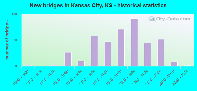
- New bridges - historical statistics
- 21900-1909
- 21920-1929
- 271930-1939
- 101940-1949
- 581950-1959
- 471960-1969
- 711970-1979
- 911980-1989
- 451990-1999
- 522000-2009
- 92010-2019
- 12020-2022
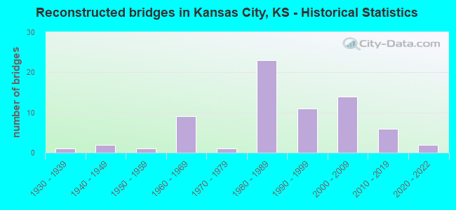
- Reconstructed bridges - Historical Statistics
- 11930-1939
- 21940-1949
- 11950-1959
- 91960-1969
- 11970-1979
- 231980-1989
- 111990-1999
- 142000-2009
- 62010-2019
- 22020-2022
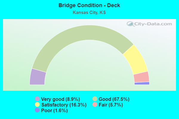
- Bridge Condition - Deck
- 8.9%Very good
- 67.5%Good
- 16.3%Satisfactory
- 5.7%Fair
- 1.6%Poor
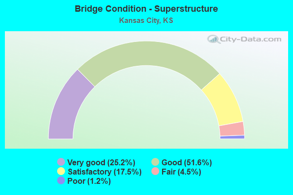
- Bridge Condition - Superstructure
- 25.2%Very good
- 51.6%Good
- 17.5%Satisfactory
- 4.5%Fair
- 1.2%Poor
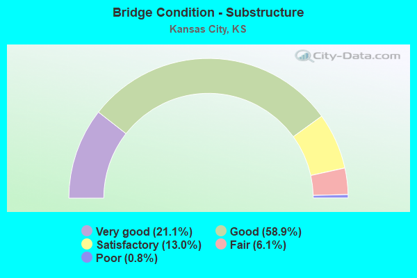
- Bridge Condition - Substructure
- 21.1%Very good
- 58.9%Good
- 13.0%Satisfactory
- 6.1%Fair
- 0.8%Poor
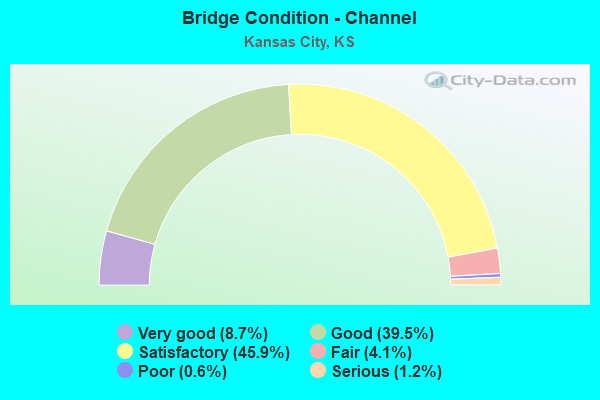
- Bridge Condition - Channel
- 8.7%Very good
- 39.5%Good
- 45.9%Satisfactory
- 4.1%Fair
- 0.6%Poor
- 1.2%Serious
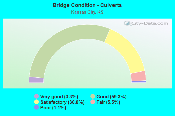
- Bridge Condition - Culverts
- 3.3%Very good
- 59.3%Good
- 30.8%Satisfactory
- 5.5%Fair
- 1.1%Poor
Find on map >> Show street view
Structure Number: 514301050000062, Location: 86TH. S. OF KANSAS AVE. (Lat: 39.086669, Lng: -94.779053), Route carried "on" structure: City street , Year Built: 1987, Status: Open, Structure Length: 4.05m (13.29ft), Average Daily Traffic: 700 (year 2007), Truck Traffic: 1%, Average Future Daily Traffic: 750 (year 2043), Design Load: HS 20, Features Intersected: LITTLE TURKEY CREEK, Facility Carried by Structure: 86TH STREET
Minimum Vertical Clearance: 30.47m (99.97ft), Kilometerpoint: 0.000, Lanes on structure: 2, Owner: County Highway Agency, Approaching Roadway Width: 7.3m (24.0ft), Material/Design: Prestressed concrete continuous, Design/Construction: Stringer/Multi-beam, Number Of Spans In Main Unit: 3, Length of Maximum Span: 15.2m (49.9ft), Curb-To-Curb Width: 9.8m (32.2ft), Out-to-Out Width: 10.4m (34.1ft)
Condition: Deck: Satisfactory, Superstructure: Good, Substructure: Very good, Channel: Good, Operating Rating: 45.2 metric tons, Method Used To Determine Operating Rating: Load Factor (LF), Inventory Rating: 25.9 metric tons, Method Used To Determine Inventory Rating: Load Factor (LF), Structural Evaluation: Equal to present minimum criteria, Deck Geometry: Equal to present minimum criteria, Waterway Adequacy: Equal to present desirable criteria, Approach Roadway Alignment: Equal to present desirable criteria, Designated Inspection Frequency: Every 24 months, Inspection Date: March 2021, Deck Structure Type: Concrete Cast-file-Place
Find on map >> Show street view
Structure Number: 514301050000065, Location: W. KS AVE. E. OF 86TH ST. (Lat: 39.087247, Lng: -94.778736), Route carried "on" structure: City street , Year Built: 1987, Status: Open, Structure Length: 1.33m (4.36ft), Average Daily Traffic: 1,365 (year 2013), Truck Traffic: 1%, Average Future Daily Traffic: 2,000 (year 2043), Design Load: HS 20, Features Intersected: LITTLE TURKEY CK. TRIB., Facility Carried by Structure: KANSAS AVENUE
Minimum Vertical Clearance: 30.47m (99.97ft), Kilometerpoint: 0.000, Lanes on structure: 2, Owner: County Highway Agency, Approaching Roadway Width: 8.8m (28.9ft), Material/Design: Concrete, Design/Construction: Culvert, Number Of Spans In Main Unit: 3, Length of Maximum Span: 4.3m (14.1ft)
Condition: Channel: Satisfactory, Culverts: Good, Operating Rating: 68.0 metric tons, Method Used To Determine Operating Rating: Load Factor (LF), Inventory Rating: 40.7 metric tons, Method Used To Determine Inventory Rating: Load Factor (LF), Structural Evaluation: Better than present minimum criteria, Waterway Adequacy: Better than present minimum criteria, Approach Roadway Alignment: Equal to present desirable criteria, Designated Inspection Frequency: Every 24 months, Inspection Date: March 2021, Other Special Inspection Date: Febuary 2019
Find on map >> Show street view
Structure Number: 514301050000066, Location: 8800 KANSAS AVE (Lat: 39.087275, Lng: -94.781775), Route carried "on" structure: City street , Year Built: 1976, Status: Open, Structure Length: 2.01m (6.59ft), Average Daily Traffic: 1,610 (year 2013), Truck Traffic: 1%, Average Future Daily Traffic: 2,000 (year 2043), Design Load: H 20, Features Intersected: LITTLE TURKEY CREEK, Facility Carried by Structure: KANSAS AVENUE
Minimum Vertical Clearance: 30.47m (99.97ft), Kilometerpoint: 0.000, Lanes on structure: 2, Owner: County Highway Agency, Approaching Roadway Width: 9.1m (29.9ft), Skew: 2 degrees, Material/Design: Prestressed concrete, Design/Construction: Tee Beam, Number Of Spans In Main Unit: 1, Length of Maximum Span: 18.7m (61.4ft), Curb-To-Curb Width: 9.4m (30.8ft), Out-to-Out Width: 9.8m (32.2ft)
Condition: Deck: Very good, Superstructure: Very good, Substructure: Good, Channel: Good, Operating Rating: 43.0 metric tons, Method Used To Determine Operating Rating: Load Factor (LF), Inventory Rating: 18.2 metric tons, Method Used To Determine Inventory Rating: Load Factor (LF), Structural Evaluation: Somewhat better than minimum adequacy, Deck Geometry: Somewhat better than minimum adequacy, Waterway Adequacy: Better than present minimum criteria, Approach Roadway Alignment: Better than present minimum criteria, Length Of Structure Improvement: 13.72m (45.01ft), Designated Inspection Frequency: Every 24 months, Inspection Date: March 2021, Other Special Inspection Date: Febuary 2019, Total Project Cost: $1,000, Deck Structure Type: Concrete Cast-file-Place
Find on map >> Show street view
Structure Number: 514301050000075, Location: 11240 HUBBARD (Lat: 39.179481, Lng: -94.839667), Route carried "on" structure: City street , Year Built: 1995, Status: Open, Structure Length: 1.13m (3.71ft), Average Daily Traffic: 313 (year 1992), Truck Traffic: 1%, Average Future Daily Traffic: 350 (year 2043), Design Load: HS 20, Features Intersected: HONEY CREEK, Facility Carried by Structure: HUBBARD ST
Minimum Vertical Clearance: 30.47m (99.97ft), Kilometerpoint: 0.000, Lanes on structure: 2, Owner: County Highway Agency, Approaching Roadway Width: 5.7m (18.7ft), Material/Design: Concrete, Design/Construction: Culvert, Number Of Spans In Main Unit: 3, Length of Maximum Span: 3.7m (12.1ft)
Condition: Channel: Satisfactory, Culverts: Good, Inventory Rating: 62.3 metric tons, Method Used To Determine Inventory Rating: Load Factor (LF), Structural Evaluation: Better than present minimum criteria, Waterway Adequacy: Better than present minimum criteria, Approach Roadway Alignment: Equal to present desirable criteria, Designated Inspection Frequency: Every 24 months, Inspection Date: March 2021, Other Special Inspection Date: Febuary 2019
Find on map >> Show street view
Structure Number: 514301050000078, Location: BRENNER DR. AT DICKINSON (Lat: 39.166047, Lng: -94.705592), Route carried "on" structure: City street , Year Built: 1979, Status: Open, Structure Length: 2.80m (9.19ft), Average Daily Traffic: 451 (year 1992), Truck Traffic: 5%, Average Future Daily Traffic: 675 (year 2043), Design Load: HS 20, Features Intersected: STREAM, Facility Carried by Structure: DICKINSON ROAD
Minimum Vertical Clearance: 30.47m (99.97ft), Kilometerpoint: 0.000, Lanes on structure: 2, Owner: County Highway Agency, Approaching Roadway Width: 7.3m (24.0ft), Material/Design: Prestressed concrete continuous, Design/Construction: Tee Beam, Number Of Spans In Main Unit: 2, Length of Maximum Span: 13.7m (44.9ft), Curb-To-Curb Width: 7.3m (24.0ft), Out-to-Out Width: 8.1m (26.6ft)
Condition: Deck: Satisfactory, Superstructure: Good, Substructure: Good, Channel: Satisfactory, Operating Rating: 50.0 metric tons, Method Used To Determine Operating Rating: Load Factor (LF), Inventory Rating: 27.0 metric tons, Method Used To Determine Inventory Rating: Load Factor (LF), Structural Evaluation: Equal to present minimum criteria, Deck Geometry: Meets minimum limits, Waterway Adequacy: Equal to present minimum criteria, Approach Roadway Alignment: Equal to present minimum criteria, Length Of Structure Improvement: 19.81m (64.99ft), Designated Inspection Frequency: Every 24 months, Inspection Date: March 2021, Other Special Inspection Date: November 2020, Total Project Cost: $1,000 ( Estimate for 2015), Deck Structure Type: Concrete Cast-file-Place
Find on map >> Show street view
Structure Number: 514301050000079, Location: 99TH. ST. S OF HUTTON (Lat: 39.183886, Lng: -94.807783), Route carried "on" structure: City street , Year Built: 1940, Year Reconstructed: 1993, Status: Posted for load, Structure Length: 1.07m (3.51ft), Average Daily Traffic: 32 (year 1992), Average Future Daily Traffic: 45 (year 2043), Design Load: H 20, Features Intersected: CONNOR CREEK TRIBUTARY, Facility Carried by Structure: 99TH STREET
Minimum Vertical Clearance: 30.47m (99.97ft), Kilometerpoint: 0.000, Lanes on structure: 1, Owner: County Highway Agency, Approaching Roadway Width: 3.6m (11.8ft), Material/Design: Steel, Design/Construction: Stringer/Multi-beam, Number Of Spans In Main Unit: 1, Length of Maximum Span: 7.9m (25.9ft), Curb-To-Curb Width: 4.1m (13.5ft), Out-to-Out Width: 4.6m (15.1ft)
Condition: Deck: Very good, Superstructure: Fair, Substructure: Fair, Channel: Fair, Operating Rating: 8.3 metric tons, Method Used To Determine Operating Rating: Load Factor (LF), Inventory Rating: 5.0 metric tons, Method Used To Determine Inventory Rating: Load Factor (LF), Structural Evaluation: High priority of replacement, Deck Geometry: Somewhat better than minimum adequacy, Waterway Adequacy: Equal to present desirable criteria, Approach Roadway Alignment: Somewhat better than minimum adequacy, Bridge Posting: Required (Relationship of Operating Rating to Maximum Legal Load: > 39.9% below), Length Of Structure Improvement: 1.98m (6.50ft), Designated Inspection Frequency: Every 24 months, Inspection Date: March 2021, Bridge Improvement Cost: $250,000, Roadway Improvement Cost: $135,000, Total Project Cost: $385,000, Deck Structure Type: Concrete Cast-file-Place
Find on map >> Show street view
Structure Number: 514301050000081, Location: 9800 HOLLINGSWORTH (Lat: 39.176164, Lng: -94.805361), Route carried "on" structure: City street , Year Built: 1985, Status: Open, Structure Length: 5.79m (19.00ft), Average Daily Traffic: 180 (year 2013), Truck Traffic: 1%, Average Future Daily Traffic: 250 (year 2043), Design Load: HS 20, Features Intersected: CONNOR CREEK, Facility Carried by Structure: 97TH STREET
Minimum Vertical Clearance: 30.47m (99.97ft), Kilometerpoint: 0.000, Lanes on structure: 2, Owner: County Highway Agency, Approaching Roadway Width: 8.5m (27.9ft), Skew: 4 degrees, Material/Design: Prestressed concrete continuous, Design/Construction: Stringer/Multi-beam, Number Of Spans In Main Unit: 3, Length of Maximum Span: 19.2m (63.0ft), Curb-To-Curb Width: 8.5m (27.9ft), Out-to-Out Width: 9.3m (30.5ft)
Condition: Deck: Good, Superstructure: Very good, Substructure: Good, Channel: Satisfactory, Operating Rating: 44.5 metric tons, Method Used To Determine Operating Rating: Allowable Stress (AS), Inventory Rating: 29.0 metric tons, Method Used To Determine Inventory Rating: Allowable Stress (AS), Structural Evaluation: Better than present minimum criteria, Deck Geometry: Equal to present minimum criteria, Waterway Adequacy: Equal to present minimum criteria, Approach Roadway Alignment: Equal to present desirable criteria, Designated Inspection Frequency: Every 24 months, Inspection Date: March 2021, Deck Structure Type: Concrete Cast-file-Place
Find on map >> Show street view
Structure Number: 514301050000083, Location: 10500 DONAHOO (Lat: 39.158297, Lng: -94.819683), Route carried "on" structure: City street , Year Built: 2007, Status: Open, Structure Length: 1.60m (5.25ft), Average Daily Traffic: 1,230 (year 2013), Truck Traffic: 1%, Average Future Daily Traffic: 1,500 (year 2043), Design Load: HS 20, Features Intersected: CONNOR CREEK, Facility Carried by Structure: DONOHOO STREET
Minimum Vertical Clearance: 30.47m (99.97ft), Kilometerpoint: 0.000, Lanes on structure: 3, Owner: County Highway Agency, Approaching Roadway Width: 12.8m (42.0ft), Skew: 2 degrees, Material/Design: Concrete, Design/Construction: Culvert, Number Of Spans In Main Unit: 3, Length of Maximum Span: 5.2m (17.1ft)
Condition: Channel: Good, Culverts: Good, Operating Rating: 54.4 metric tons, Method Used To Determine Operating Rating: Load Factor (LF), Inventory Rating: 32.7 metric tons, Method Used To Determine Inventory Rating: Load Factor (LF), Structural Evaluation: Better than present minimum criteria, Waterway Adequacy: Equal to present desirable criteria, Approach Roadway Alignment: Equal to present desirable criteria, Designated Inspection Frequency: Every 24 months, Inspection Date: March 2021, Deck Structure Type: Concrete Cast-file-Place
Find on map >> Show street view
Structure Number: 514301050000097, Location: 59th St North of Parallel (Lat: 39.129458, Lng: -94.715272), Route carried "on" structure: City street , Year Built: 1975, Status: Open, Structure Length: 0.74m (2.43ft), Average Daily Traffic: 4,930 (year 2013), Truck Traffic: 5%, Average Future Daily Traffic: 7,400 (year 2043), Design Load: H 15, Features Intersected: Brenner Heights Creek, Facility Carried by Structure: 59th Street
Minimum Vertical Clearance: 30.47m (99.97ft), Kilometerpoint: 0.000, Lanes on structure: 4, Owner: County Highway Agency, Approaching Roadway Width: 15.8m (51.8ft), Skew: 32 degrees, Material/Design: Concrete, Design/Construction: Culvert, Number Of Spans In Main Unit: 3, Length of Maximum Span: 2.6m (8.5ft), Curb or Sidewalk Widths: Left: 1.5m (4.9ft), Right: 0.0m
Condition: Channel: Good, Culverts: Good, Operating Rating: 54.4 metric tons, Method Used To Determine Operating Rating: Field evaluation and documented engineering judgment, Inventory Rating: 32.7 metric tons, Method Used To Determine Inventory Rating: Field evaluation and documented engineering judgment, Structural Evaluation: Better than present minimum criteria, Waterway Adequacy: Equal to present desirable criteria, Approach Roadway Alignment: Equal to present desirable criteria, Designated Inspection Frequency: Every 24 months, Inspection Date: March 2021
Find on map >> Show street view
Structure Number: 514301050000134, Location: ROE LANE AND ALMA (Lat: 39.052908, Lng: -94.642861), Route carried "on" structure: City street , Year Built: 1987, Status: Open, Structure Length: 4.05m (13.29ft), Average Daily Traffic: 4,720 (year 2013), Truck Traffic: 5%, Average Future Daily Traffic: 5,900 (year 2043), Design Load: HS 20, Features Intersected: TURKEY CREEK, Facility Carried by Structure: ROE LANE
Minimum Vertical Clearance: 30.47m (99.97ft), Kilometerpoint: 0.000, Lanes on structure: 2, Owner: County Highway Agency, Approaching Roadway Width: 9.7m (31.8ft), Material/Design: Concrete continuous, Design/Construction: Slab, Number Of Spans In Main Unit: 3, Length of Maximum Span: 15.8m (51.8ft), Curb or Sidewalk Widths: Left: 1.5m (4.9ft), Right: 0.0m, Curb-To-Curb Width: 9.8m (32.2ft), Out-to-Out Width: 12.2m (40.0ft)
Condition: Deck: Good, Superstructure: Good, Substructure: Good, Channel: Satisfactory, Operating Rating: 78.1 metric tons, Method Used To Determine Operating Rating: Load Factor (LF), Inventory Rating: 46.7 metric tons, Method Used To Determine Inventory Rating: Load Factor (LF), Structural Evaluation: Better than present minimum criteria, Deck Geometry: Meets minimum limits, Waterway Adequacy: Somewhat better than minimum adequacy, Approach Roadway Alignment: Equal to present desirable criteria, Designated Inspection Frequency: Every 24 months, Inspection Date: March 2021, Deck Structure Type: Concrete Cast-file-Place, Wearing Surface/Protective System: Deck Protection: Epoxy Coated Reinforcing
Find on map >> Show street view
Structure Number: 514301050000143, Location: MILL STREET VIADUCT (Lat: 39.090211, Lng: -94.630669), Route carried "on" structure: City street , Year Built: 1964, Status: Open, Structure Length: 44.68m (146.59ft), Average Daily Traffic: 5,824 (year 1992), Truck Traffic: 1%, Average Future Daily Traffic: 6,500 (year 2043), Design Load: H 20, Features Intersected: I-70, RAILROAD YARD, Facility Carried by Structure: MILL STREET
Minimum Vertical Clearance: 9.14m (29.99ft), Kilometerpoint: 0.000, Lanes on structure: 2, Lanes under structure: 6, Owner: County Highway Agency, Approaching Roadway Width: 7.9m (25.9ft), Material/Design: Steel continuous, Design/Construction: Stringer/Multi-beam, Number Of Spans In Main Unit: 11, Number Of Approach Spans: 12, Length of Maximum Span: 33.2m (108.9ft), Curb or Sidewalk Widths: Left: 0.9m (3.0ft), Right: 0.5m (1.6ft), Curb-To-Curb Width: 7.9m (25.9ft), Out-to-Out Width: 9.9m (32.5ft)
Condition: Deck: Fair, Superstructure: Satisfactory, Substructure: Fair, Operating Rating: 47.0 metric tons, Method Used To Determine Operating Rating: Load Factor (LF), Inventory Rating: 28.1 metric tons, Method Used To Determine Inventory Rating: Load Factor (LF), Structural Evaluation: Somewhat better than minimum adequacy, Deck Geometry: High priority of corrective action, Underclear: Somewhat better than minimum adequacy, Approach Roadway Alignment: Equal to present minimum criteria, Length Of Structure Improvement: 48.77m (160.01ft), Designated Inspection Frequency: Every 24 months, Inspection Date: March 2021, Bridge Improvement Cost: $10,000, Total Project Cost: $15,000 ( Estimate for 2015), Deck Structure Type: Concrete Cast-file-Place
Find on map >> Show street view
Structure Number: 514301050000144, Location: 10TH. ST. VIADUCT (Lat: 39.090897, Lng: -94.635322), Route carried "on" structure: City street , Year Built: 1994, Status: Open, Structure Length: 24.06m (78.94ft), Average Daily Traffic: 6,585 (year 2013), Truck Traffic: 10%, Average Future Daily Traffic: 9,900 (year 2043), Design Load: HS 20, Features Intersected: I-70, RAILROAD YARD, Facility Carried by Structure: 10TH STREET
Minimum Vertical Clearance: 5.21m (17.09ft), Kilometerpoint: 0.000, Lanes on structure: 2, Lanes under structure: 4, Owner: County Highway Agency, Approaching Roadway Width: 12.1m (39.7ft), Skew: 1 degrees, Material/Design: Steel continuous, Design/Construction: Stringer/Multi-beam, Number Of Spans In Main Unit: 8, Number Of Approach Spans: 2, Length of Maximum Span: 31.4m (103.0ft), Curb or Sidewalk Widths: Left: 0.0m, Right: 1.5m (4.9ft), Curb-To-Curb Width: 9.8m (32.2ft), Out-to-Out Width: 12.4m (40.7ft)
Condition: Deck: Good, Superstructure: Good, Substructure: Good, Operating Rating: 56.5 metric tons, Method Used To Determine Operating Rating: Load Factor (LF), Inventory Rating: 33.8 metric tons, Method Used To Determine Inventory Rating: Load Factor (LF), Structural Evaluation: Better than present minimum criteria, Deck Geometry: Meets minimum limits, Underclear: Meets minimum limits, Approach Roadway Alignment: Equal to present desirable criteria, Designated Inspection Frequency: Every 24 months, Inspection Date: March 2021, Other Special Inspection Date: July 2019, Deck Structure Type: Concrete Cast-file-Place, Wearing Surface/Protective System: Wearing Surface: Monolithic Concrete, Deck Protection: Epoxy Coated Reinforcing
Find on map >> Show street view
Structure Number: 514301050000148, Location: SHAWNEE RD OVER 7TH ST (Lat: 39.071903, Lng: -94.620867), Route carried "on" structure: City street , Year Built: 1933, Year Reconstructed: 2013, Status: Posted for load, Structure Length: 2.91m (9.55ft), Average Daily Traffic: 697 (year 1990), Truck Traffic: 1%, Average Future Daily Traffic: 900 (year 2043), Design Load: HS 20, Features Intersected: 7TH ST TRAFFICWAY, Facility Carried by Structure: SHAWNEE ROAD
Minimum Vertical Clearance: 6.27m (20.57ft), Kilometerpoint: 0.000, Lanes on structure: 2, Lanes under structure: 4, Owner: County Highway Agency, Approaching Roadway Width: 9.1m (29.9ft), Material/Design: Steel, Design/Construction: Arch - Deck, Number Of Spans In Main Unit: 1, Length of Maximum Span: 29.1m (95.5ft), Curb or Sidewalk Widths: Left: 1.5m (4.9ft), Right: 1.5m (4.9ft), Curb-To-Curb Width: 7.3m (24.0ft), Out-to-Out Width: 11.4m (37.4ft)
Condition: Deck: Good, Superstructure: Satisfactory, Substructure: Fair, Operating Rating: 19.5 metric tons, Method Used To Determine Operating Rating: Load Factor (LF), Inventory Rating: 19.2 metric tons, Method Used To Determine Inventory Rating: Load Factor (LF), Structural Evaluation: Somewhat better than minimum adequacy, Deck Geometry: Meets minimum limits, Underclear: Meets minimum limits, Approach Roadway Alignment: Better than present minimum criteria, Bridge Posting: Required (Relationship of Operating Rating to Maximum Legal Load: > 39.9% below), Designated Inspection Frequency: Every 24 months, Inspection Date: March 2021, Deck Structure Type: Concrete Cast-file-Place, Wearing Surface/Protective System: Wearing Surface: Monolithic Concrete, Deck Protection: Epoxy Coated Reinforcing
Find on map >> Show street view
Structure Number: 514301050000149, Location: MISSION RD. VIADUCT (Lat: 39.060392, Lng: -94.624869), Route carried "on" structure: City street , Year Built: 1965, Year Reconstructed: 2005, Status: Open, Structure Length: 20.54m (67.39ft), Average Daily Traffic: 17,850 (year 2013), Truck Traffic: 15%, Average Future Daily Traffic: 26,700 (year 2043), Design Load: H 20, Features Intersected: RR YARD, TURKEY CK, Facility Carried by Structure: MISSION ROAD
Minimum Vertical Clearance: 30.47m (99.97ft), Kilometerpoint: 0.000, Lanes on structure: 2, Lanes under structure: 2, Owner: County Highway Agency, Approaching Roadway Width: 15.8m (51.8ft), Skew: 31 degrees, Material/Design: Steel continuous, Design/Construction: Stringer/Multi-beam, Number Of Spans In Main Unit: 6, Length of Maximum Span: 42.7m (140.1ft), Curb-To-Curb Width: 15.8m (51.8ft), Out-to-Out Width: 16.8m (55.1ft)
Condition: Deck: Good, Superstructure: Very good, Substructure: Good, Channel: Very good, Operating Rating: 42.6 metric tons, Method Used To Determine Operating Rating: Load Factor (LF), Inventory Rating: 25.5 metric tons, Method Used To Determine Inventory Rating: Load Factor (LF), Structural Evaluation: Equal to present minimum criteria, Deck Geometry: Superior to present desirable criteria, Underclear: Somewhat better than minimum adequacy, Waterway Adequacy: Equal to present desirable criteria, Approach Roadway Alignment: Equal to present desirable criteria, Designated Inspection Frequency: Every 24 months, Inspection Date: March 2021, Deck Structure Type: Concrete Cast-file-Place, Wearing Surface/Protective System: Wearing Surface: Latex Concrete, Deck Protection: Epoxy Coated Reinforcing
Find on map >> Show street view
Structure Number: 514301050000151, Location: MERRIAM LN W OF ESPENLAUB (Lat: 39.049397, Lng: -94.651500), Route carried "on" structure: City street , Year Built: 1987, Status: Open, Structure Length: 0.91m (2.99ft), Average Daily Traffic: 7,720 (year 2013), Truck Traffic: 5%, Average Future Daily Traffic: 11,600 (year 2043), Design Load: HS 20, Features Intersected: STREAM, Facility Carried by Structure: MERRIAM LANE
Minimum Vertical Clearance: 7.62m (25.00ft), Kilometerpoint: 0.000, Lanes on structure: 2, Owner: County Highway Agency, Approaching Roadway Width: 11.4m (37.4ft), Skew: 3 degrees, Material/Design: Concrete, Design/Construction: Culvert, Number Of Spans In Main Unit: 3, Length of Maximum Span: 2.9m (9.5ft), Curb or Sidewalk Widths: Left: 1.5m (4.9ft), Right: 1.5m (4.9ft)
Condition: Channel: Satisfactory, Culverts: Satisfactory, Operating Rating: 32.7 metric tons, Method Used To Determine Operating Rating: Allowable Stress (AS), Inventory Rating: 24.5 metric tons, Method Used To Determine Inventory Rating: Allowable Stress (AS), Structural Evaluation: Equal to present minimum criteria, Waterway Adequacy: Equal to present minimum criteria, Approach Roadway Alignment: Equal to present desirable criteria, Designated Inspection Frequency: Every 24 months, Inspection Date: March 2021
Find on map >> Show street view
Structure Number: 514301050000166, Location: 71ST. ST. N. OF GIBBS (Lat: 39.059608, Lng: -94.742519), Route carried "on" structure: City street , Year Built: 1993, Status: Open, Structure Length: 0.67m (2.20ft), Average Daily Traffic: 150 (year 1993), Truck Traffic: 1%, Average Future Daily Traffic: 180 (year 2043), Design Load: HS 20, Features Intersected: STREAM, Facility Carried by Structure: 71ST ST
Minimum Vertical Clearance: 30.47m (99.97ft), Kilometerpoint: 0.000, Lanes on structure: 2, Owner: County Highway Agency, Approaching Roadway Width: 7.3m (24.0ft), Skew: 3 degrees, Material/Design: Concrete, Design/Construction: Culvert, Number Of Spans In Main Unit: 2, Length of Maximum Span: 3.2m (10.5ft)
Condition: Channel: Good, Culverts: Good, Operating Rating: 43.5 metric tons, Method Used To Determine Operating Rating: Allowable Stress (AS), Inventory Rating: 32.7 metric tons, Method Used To Determine Inventory Rating: Allowable Stress (AS), Structural Evaluation: Better than present minimum criteria, Waterway Adequacy: Equal to present minimum criteria, Approach Roadway Alignment: Equal to present desirable criteria, Designated Inspection Frequency: Every 24 months, Inspection Date: March 2021
Find on map >> Show street view
Structure Number: 514301050000171, Location: OAK GROVE RD W OF 59TH ST (Lat: 39.054881, Lng: -94.718056), Route carried "on" structure: City street , Year Built: 2002, Status: Open, Structure Length: 1.12m (3.67ft), Average Daily Traffic: 1,020 (year 2013), Truck Traffic: 5%, Average Future Daily Traffic: 1,500 (year 2043), Design Load: HS 20, Features Intersected: STREAM, Facility Carried by Structure: OAK GROVE ROAD
Minimum Vertical Clearance: 30.47m (99.97ft), Kilometerpoint: 0.000, Lanes on structure: 2, Owner: County Highway Agency, Approaching Roadway Width: 7.9m (25.9ft), Skew: 3 degrees, Material/Design: Concrete, Design/Construction: Culvert, Number Of Spans In Main Unit: 3, Length of Maximum Span: 3.6m (11.8ft)
Condition: Channel: Satisfactory, Culverts: Good, Operating Rating: 96.2 metric tons, Method Used To Determine Operating Rating: Load Factor (LF), Inventory Rating: 57.2 metric tons, Method Used To Determine Inventory Rating: Load Factor (LF), Structural Evaluation: Better than present minimum criteria, Waterway Adequacy: Better than present minimum criteria, Approach Roadway Alignment: Equal to present desirable criteria, Designated Inspection Frequency: Every 24 months, Inspection Date: March 2021
Find on map >> Show street view
Structure Number: 514301050000177, Location: 5820 SWARTZ (Lat: 39.080378, Lng: -94.712753), Route carried "on" structure: City street , Year Built: 1980, Status: Open, Structure Length: 0.87m (2.85ft), Average Daily Traffic: 2,895 (year 2007), Truck Traffic: 1%, Average Future Daily Traffic: 5,700 (year 2043), Design Load: H 20, Features Intersected: STREAM, Facility Carried by Structure: SWARTZ STREET
Minimum Vertical Clearance: 30.47m (99.97ft), Kilometerpoint: 0.000, Lanes on structure: 2, Owner: County Highway Agency, Approaching Roadway Width: 9.4m (30.8ft), Skew: 3 degrees, Material/Design: Concrete, Design/Construction: Culvert, Number Of Spans In Main Unit: 2, Length of Maximum Span: 4.2m (13.8ft)
Condition: Channel: Good, Culverts: Fair, Operating Rating: 52.0 metric tons, Method Used To Determine Operating Rating: Load Factor (LF), Inventory Rating: 31.1 metric tons, Method Used To Determine Inventory Rating: Load Factor (LF), Structural Evaluation: Somewhat better than minimum adequacy, Waterway Adequacy: Equal to present minimum criteria, Approach Roadway Alignment: Meets minimum limits, Designated Inspection Frequency: Every 24 months, Inspection Date: March 2021
Find on map >> Show street view
Structure Number: 514301050000212, Location: SILVER AVE. OVER 30TH. ST (Lat: 39.072581, Lng: -94.663611), Route carried "on" structure: City street , Year Built: 1965, Status: Open, Structure Length: 1.59m (5.22ft), Average Daily Traffic: 2,115 (year 2013), Truck Traffic: 1%, Average Future Daily Traffic: 3,000 (year 2043), Design Load: HS 20, Features Intersected: 30TH STREET, Facility Carried by Structure: SILVER STREET
Minimum Vertical Clearance: 30.47m (99.97ft), Kilometerpoint: 0.000, Lanes on structure: 2, Lanes under structure: 2, Owner: County Highway Agency, Approaching Roadway Width: 8.8m (28.9ft), Skew: 1 degrees, Material/Design: Concrete, Design/Construction: Slab, Number Of Spans In Main Unit: 1, Length of Maximum Span: 13.9m (45.6ft), Curb or Sidewalk Widths: Left: 0.5m (1.6ft), Right: 1.7m (5.6ft), Curb-To-Curb Width: 8.6m (28.2ft), Out-to-Out Width: 11.4m (37.4ft)
Condition: Deck: Satisfactory, Superstructure: Satisfactory, Substructure: Satisfactory, Operating Rating: 35.4 metric tons, Method Used To Determine Operating Rating: Allowable Stress (AS), Inventory Rating: 23.6 metric tons, Method Used To Determine Inventory Rating: Allowable Stress (AS), Structural Evaluation: Equal to present minimum criteria, Deck Geometry: Meets minimum limits, Underclear: Equal to present minimum criteria, Approach Roadway Alignment: Equal to present minimum criteria, Length Of Structure Improvement: 13.72m (45.01ft), Designated Inspection Frequency: Every 24 months, Inspection Date: March 2021, Total Project Cost: $1,000, Deck Structure Type: Concrete Cast-file-Place, Wearing Surface/Protective System: Wearing Surface: Bituminous
Find on map >> Show street view
Structure Number: 514301050000225, Location: 6TH STREET OVER REYNOLDS (Lat: 39.104511, Lng: -94.623497), Route carried "on" structure: City street , Year Built: 1982, Status: Open, Structure Length: 4.11m (13.48ft), Average Daily Traffic: 1,250 (year 1991), Truck Traffic: 5%, Average Future Daily Traffic: 1,400 (year 2043), Design Load: HS 20, Features Intersected: REYNOLDS STREET, Facility Carried by Structure: 6TH STREET
Minimum Vertical Clearance: 7.62m (25.00ft), Kilometerpoint: 0.000, Lanes on structure: 2, Lanes under structure: 2, Owner: County Highway Agency, Approaching Roadway Width: 10.0m (32.8ft), Material/Design: Steel continuous, Design/Construction: Stringer/Multi-beam, Number Of Spans In Main Unit: 3, Length of Maximum Span: 18.3m (60.0ft), Curb or Sidewalk Widths: Left: 0.0m, Right: 1.8m (5.9ft), Curb-To-Curb Width: 9.8m (32.2ft), Out-to-Out Width: 12.5m (41.0ft)
Condition: Deck: Good, Superstructure: Good, Substructure: Good, Operating Rating: 81.5 metric tons, Method Used To Determine Operating Rating: Load Factor (LF), Inventory Rating: 48.8 metric tons, Method Used To Determine Inventory Rating: Load Factor (LF), Structural Evaluation: Better than present minimum criteria, Deck Geometry: Somewhat better than minimum adequacy, Underclear: High priority of corrective action, Approach Roadway Alignment: Equal to present desirable criteria, Designated Inspection Frequency: Every 24 months, Inspection Date: March 2021, Other Special Inspection Date: January 2001, Deck Structure Type: Concrete Cast-file-Place
Find on map >> Show street view
Structure Number: 514301050000229, Location: 3RD ST AT JERSEY CREEK (Lat: 39.121422, Lng: -94.616111), Route carried "on" structure: City street , Year Built: 1993, Status: Open, Structure Length: 1.01m (3.31ft), Average Daily Traffic: 3,895 (year 1991), Truck Traffic: 15%, Average Future Daily Traffic: 4,800 (year 2043), Design Load: HS 20, Features Intersected: JERSEY CREEK, Facility Carried by Structure: 3RD STREET
Minimum Vertical Clearance: 30.47m (99.97ft), Kilometerpoint: 0.000, Lanes on structure: 2, Owner: County Highway Agency, Approaching Roadway Width: 15.2m (49.9ft), Material/Design: Concrete, Design/Construction: Culvert, Number Of Spans In Main Unit: 2, Length of Maximum Span: 4.9m (16.1ft), Curb or Sidewalk Widths: Left: 1.5m (4.9ft), Right: 1.5m (4.9ft), Curb-To-Curb Width: 15.2m (49.9ft), Out-to-Out Width: 19.2m (63.0ft)
Condition: Channel: Good, Culverts: Good, Inventory Rating: 89.4 metric tons, Method Used To Determine Inventory Rating: Load Factor (LF), Structural Evaluation: Better than present minimum criteria, Deck Geometry: Superior to present desirable criteria, Waterway Adequacy: Somewhat better than minimum adequacy, Approach Roadway Alignment: Equal to present desirable criteria, Designated Inspection Frequency: Every 24 months, Inspection Date: March 2021
Find on map >> Show street view
Structure Number: 514301050000231, Location: 5TH ST AT JERSEY CREEK (Lat: 39.123050, Lng: -94.621431), Route carried "on" structure: City street , Year Built: 1999, Status: Open, Structure Length: 0.98m (3.22ft), Average Daily Traffic: 4,590 (year 2013), Truck Traffic: 5%, Average Future Daily Traffic: 6,900 (year 2043), Design Load: HS 20, Features Intersected: JERSEY CREEK, Facility Carried by Structure: 5TH STREET
Minimum Vertical Clearance: 30.47m (99.97ft), Kilometerpoint: 0.000, Lanes on structure: 4, Owner: County Highway Agency, Approaching Roadway Width: 17.0m (55.8ft), Skew: 2 degrees, Material/Design: Concrete, Design/Construction: Culvert, Number Of Spans In Main Unit: 2, Length of Maximum Span: 4.7m (15.4ft), Curb or Sidewalk Widths: Left: 3.0m (9.8ft), Right: 1.5m (4.9ft)
Condition: Channel: Good, Culverts: Good, Inventory Rating: 15.8 metric tons, Method Used To Determine Inventory Rating: Load Factor (LF), Structural Evaluation: Meets minimum limits, Waterway Adequacy: Equal to present desirable criteria, Approach Roadway Alignment: Equal to present desirable criteria, Designated Inspection Frequency: Every 24 months, Inspection Date: March 2021
Find on map >> Show street view
Structure Number: 514301050000234, Location: JAMES ST OVER UP RR (Lat: 39.100300, Lng: -94.607356), Route carried "on" structure: City street , Year Built: 1982, Status: Open, Structure Length: 19.57m (64.21ft), Average Daily Traffic: 8,895 (year 2013), Truck Traffic: 60%, Average Future Daily Traffic: 10,230 (year 2043), Design Load: HS 20, Features Intersected: UNIONPACIFIC RAILROAD YD, Facility Carried by Structure: JAMES STREET VIA.
Minimum Vertical Clearance: 7.01m (23.00ft), Kilometerpoint: 0.000, Lanes on structure: 2, Owner: County Highway Agency, Approaching Roadway Width: 18.2m (59.7ft), Material/Design: Prestressed concrete continuous, Design/Construction: Stringer/Multi-beam, Number Of Spans In Main Unit: 7, Length of Maximum Span: 29.9m (98.1ft), Curb or Sidewalk Widths: Left: 0.0m, Right: 1.8m (5.9ft), Curb-To-Curb Width: 9.5m (31.2ft), Out-to-Out Width: 12.0m (39.4ft)
Condition: Deck: Good, Superstructure: Good, Substructure: Good, Operating Rating: 33.2 metric tons, Method Used To Determine Operating Rating: Load Factor (LF), Inventory Rating: 19.9 metric tons, Method Used To Determine Inventory Rating: Load Factor (LF), Structural Evaluation: Somewhat better than minimum adequacy, Deck Geometry: Meets minimum limits, Underclear: Meets minimum limits, Approach Roadway Alignment: Better than present minimum criteria, Designated Inspection Frequency: Every 24 months, Inspection Date: March 2021, Other Special Inspection Date: Febuary 2019, Deck Structure Type: Concrete Cast-file-Place
Find on map >> Show street view
Structure Number: 514301050000235, Location: 8-9TH ST AT JERSEY CK (Lat: 39.123333, Lng: -94.630000), Route carried "on" structure: City street , Year Built: 1971, Status: Open, Structure Length: 0.88m (2.89ft), Average Daily Traffic: 6,105 (year 1998), Truck Traffic: 5%, Average Future Daily Traffic: 6,500 (year 2043), Design Load: HS 20, Features Intersected: JERSEY CREEK, Facility Carried by Structure: 8TH TO 9TH ST
Minimum Vertical Clearance: 30.47m (99.97ft), Kilometerpoint: 0.000, Lanes on structure: 2, Owner: County Highway Agency, Approaching Roadway Width: 13.4m (44.0ft), Skew: 3 degrees, Material/Design: Concrete, Design/Construction: Culvert, Number Of Spans In Main Unit: 2, Length of Maximum Span: 4.3m (14.1ft)
Condition: Channel: Good, Culverts: Good, Operating Rating: 44.5 metric tons, Method Used To Determine Operating Rating: Allowable Stress (AS), Inventory Rating: 32.7 metric tons, Method Used To Determine Inventory Rating: Allowable Stress (AS), Structural Evaluation: Better than present minimum criteria, Waterway Adequacy: Better than present minimum criteria, Approach Roadway Alignment: Equal to present desirable criteria, Designated Inspection Frequency: Every 24 months, Inspection Date: March 2021
Find on map >> Show street view
Structure Number: 514301050000237, Location: 11TH ST AT JERSEY CREEK (Lat: 39.127983, Lng: -94.638164), Route carried "on" structure: City street , Year Built: 1940, Status: Open, Structure Length: 0.76m (2.49ft), Average Daily Traffic: 1,605 (year 1992), Truck Traffic: 1%, Average Future Daily Traffic: 2,000 (year 2043), Design Load: HS 20, Features Intersected: JERSEY CREEK, Facility Carried by Structure: 11TH STREET
Minimum Vertical Clearance: 30.47m (99.97ft), Kilometerpoint: 0.000, Lanes on structure: 2, Owner: County Highway Agency, Approaching Roadway Width: 9.1m (29.9ft), Skew: 1 degrees, Material/Design: Concrete, Design/Construction: Culvert, Number Of Spans In Main Unit: 2, Length of Maximum Span: 3.7m (12.1ft)
Condition: Channel: Good, Culverts: Fair, Operating Rating: 32.7 metric tons, Method Used To Determine Operating Rating: Allowable Stress (AS), Inventory Rating: 24.5 metric tons, Method Used To Determine Inventory Rating: Allowable Stress (AS), Structural Evaluation: Somewhat better than minimum adequacy, Waterway Adequacy: Better than present minimum criteria, Approach Roadway Alignment: Equal to present desirable criteria, Length Of Structure Improvement: 0.91m (2.99ft), Designated Inspection Frequency: Every 24 months, Inspection Date: March 2021, Bridge Improvement Cost: $120,000, Roadway Improvement Cost: $65,000, Total Project Cost: $225,000
Find on map >> Show street view
Structure Number: 514301050000238, Location: 13TH ST AT JERSEY CREEK (Lat: 39.128803, Lng: -94.643028), Route carried "on" structure: City street , Year Built: 1972, Status: Open, Structure Length: 0.70m (2.30ft), Average Daily Traffic: 2,100 (year 2013), Truck Traffic: 1%, Average Future Daily Traffic: 4,200 (year 2043), Design Load: HS 20, Features Intersected: JERSEY CREEK, Facility Carried by Structure: 13TH STREET
Minimum Vertical Clearance: 7.62m (25.00ft), Kilometerpoint: 0.000, Lanes on structure: 2, Owner: County Highway Agency, Approaching Roadway Width: 12.1m (39.7ft), Material/Design: Concrete, Design/Construction: Culvert, Number Of Spans In Main Unit: 2, Length of Maximum Span: 3.4m (11.2ft), Curb or Sidewalk Widths: Left: 1.2m (3.9ft), Right: 1.2m (3.9ft)
Condition: Channel: Good, Culverts: Good, Operating Rating: 43.5 metric tons, Method Used To Determine Operating Rating: Allowable Stress (AS), Inventory Rating: 32.7 metric tons, Method Used To Determine Inventory Rating: Allowable Stress (AS), Structural Evaluation: Better than present minimum criteria, Waterway Adequacy: Better than present minimum criteria, Approach Roadway Alignment: Equal to present desirable criteria, Designated Inspection Frequency: Every 24 months, Inspection Date: March 2021
Find on map >> Show street view
Structure Number: 514301050000243, Location: 55TH ST OVER SANTA FE RR (Lat: 39.087186, Lng: -94.705208), Route carried "on" structure: City street , Year Built: 1993, Status: Open, Structure Length: 14.57m (47.80ft), Average Daily Traffic: 12,460 (year 2013), Truck Traffic: 75%, Average Future Daily Traffic: 18,000 (year 2043), Design Load: HS 20, Features Intersected: BNSF RAILROAD YARD, Facility Carried by Structure: 55TH STREET
Minimum Vertical Clearance: 30.47m (99.97ft), Kilometerpoint: 0.000, Lanes on structure: 2, Owner: County Highway Agency, Approaching Roadway Width: 9.4m (30.8ft), Material/Design: Steel continuous, Design/Construction: Stringer/Multi-beam, Number Of Spans In Main Unit: 7, Length of Maximum Span: 26.5m (86.9ft), Curb or Sidewalk Widths: Left: 0.0m, Right: 1.5m (4.9ft), Curb-To-Curb Width: 9.8m (32.2ft), Out-to-Out Width: 12.4m (40.7ft)
Condition: Deck: Good, Superstructure: Good, Substructure: Good, Operating Rating: 60.9 metric tons, Method Used To Determine Operating Rating: Load Factor (LF), Inventory Rating: 36.5 metric tons, Method Used To Determine Inventory Rating: Load Factor (LF), Structural Evaluation: Better than present minimum criteria, Deck Geometry: Meets minimum limits, Underclear: Meets minimum limits, Approach Roadway Alignment: Equal to present desirable criteria, Designated Inspection Frequency: Every 24 months, Inspection Date: March 2021, Other Special Inspection Date: November 2020, Deck Structure Type: Concrete Cast-file-Place, Wearing Surface/Protective System: Deck Protection: Epoxy Coated Reinforcing
Find on map >> Show street view
Structure Number: 514301050000244, Location: 42ND ST OVER SANTA FE RR (Lat: 39.084928, Lng: -94.677239), Route carried "on" structure: City street , Year Built: 1948, Year Reconstructed: 1990, Status: Open, Structure Length: 78.43m (257.32ft), Average Daily Traffic: 4,190 (year 2013), Truck Traffic: 80%, Average Future Daily Traffic: 6,300 (year 2043), Design Load: H 20, Features Intersected: BNSF RAILROAD YARDS, Facility Carried by Structure: 42ND STREET
Minimum Vertical Clearance: 30.47m (99.97ft), Kilometerpoint: 0.000, Lanes on structure: 2, Owner: County Highway Agency, Approaching Roadway Width: 9.4m (30.8ft), Skew: 3 degrees, Material/Design: Steel continuous, Design/Construction: Stringer/Multi-beam, Number Of Spans In Main Unit: 26, Number Of Approach Spans: 5, Length of Maximum Span: 27.4m (89.9ft), Curb or Sidewalk Widths: Left: 0.0m, Right: 1.4m (4.6ft), Curb-To-Curb Width: 9.4m (30.8ft), Out-to-Out Width: 11.6m (38.1ft)
Condition: Deck: Good, Superstructure: Good, Substructure: Good, Operating Rating: 40.6 metric tons, Method Used To Determine Operating Rating: Load Factor (LF), Inventory Rating: 24.3 metric tons, Method Used To Determine Inventory Rating: Load Factor (LF), Structural Evaluation: Equal to present minimum criteria, Deck Geometry: Meets minimum limits, Underclear: Meets minimum limits, Approach Roadway Alignment: Better than present minimum criteria, Designated Inspection Frequency: Every 24 months, Inspection Date: March 2021, Other Special Inspection Date: August 2019, Deck Structure Type: Concrete Cast-file-Place, Wearing Surface/Protective System: Wearing Surface: Integral Concrete, Deck Protection: Epoxy Coated Reinforcing
Find on map >> Show street view
Structure Number: 514301050000245, Location: GODDARD OVER RR YARD (Lat: 39.077361, Lng: -94.662067), Route carried "on" structure: City street , Year Built: 1992, Status: Open, Structure Length: 39.50m (129.59ft), Average Daily Traffic: 1,381 (year 1992), Truck Traffic: 5%, Average Future Daily Traffic: 3,500 (year 2043), Design Load: HS 20, Features Intersected: RAILROAD YARDS, Facility Carried by Structure: GODDARD AVENUE
Minimum Vertical Clearance: 30.47m (99.97ft), Kilometerpoint: 0.000, Lanes on structure: 2, Lanes under structure: 2, Owner: County Highway Agency, Approaching Roadway Width: 9.7m (31.8ft), Skew: 1 degrees, Material/Design: Prestressed concrete continuous, Design/Construction: Stringer/Multi-beam, Number Of Spans In Main Unit: 14, Length of Maximum Span: 30.5m (100.1ft), Curb or Sidewalk Widths: Left: 0.0m, Right: 1.5m (4.9ft), Curb-To-Curb Width: 9.8m (32.2ft), Out-to-Out Width: 12.4m (40.7ft)
Condition: Deck: Good, Superstructure: Good, Substructure: Good, Operating Rating: 56.1 metric tons, Method Used To Determine Operating Rating: Load Factor (LF), Inventory Rating: 29.4 metric tons, Method Used To Determine Inventory Rating: Load Factor (LF), Structural Evaluation: Better than present minimum criteria, Deck Geometry: Somewhat better than minimum adequacy, Underclear: Meets minimum limits, Approach Roadway Alignment: Equal to present desirable criteria, Designated Inspection Frequency: Every 24 months, Inspection Date: March 2021, Deck Structure Type: Concrete Cast-file-Place, Wearing Surface/Protective System: Wearing Surface: Low Slump Concrete, Deck Protection: Epoxy Coated Reinforcing
Find on map >> Show street view
Structure Number: 514301050000248, Location: 65TH ST OVER TURNER DIAG. (Lat: 39.099439, Lng: -94.728583), Route carried "on" structure: City street , Year Built: 1958, Status: Open, Structure Length: 5.94m (19.49ft), Average Daily Traffic: 2,065 (year 2013), Truck Traffic: 5%, Average Future Daily Traffic: 2,500 (year 2043), Design Load: HS 20, Features Intersected: TURNER DIAGONAL (K132), Facility Carried by Structure: 65TH STREET
Minimum Vertical Clearance: 30.47m (99.97ft), Kilometerpoint: 0.000, Lanes on structure: 2, Lanes under structure: 4, Owner: County Highway Agency, Approaching Roadway Width: 8.8m (28.9ft), Material/Design: Concrete continuous, Design/Construction: Box Beam or Girders - Multiple, Number Of Spans In Main Unit: 4, Length of Maximum Span: 18.3m (60.0ft), Curb-To-Curb Width: 6.7m (22.0ft), Out-to-Out Width: 8.2m (26.9ft)
Condition: Deck: Satisfactory, Superstructure: Satisfactory, Substructure: Good, Operating Rating: 47.3 metric tons, Method Used To Determine Operating Rating: Load Factor (LF), Inventory Rating: 28.3 metric tons, Method Used To Determine Inventory Rating: Load Factor (LF), Structural Evaluation: Equal to present minimum criteria, Deck Geometry: High priority of replacement, Underclear: Meets minimum limits, Approach Roadway Alignment: Equal to present minimum criteria, Length Of Structure Improvement: 45.72m (150.00ft), Designated Inspection Frequency: Every 24 months, Inspection Date: March 2021, Other Special Inspection Date: Febuary 2019, Bridge Improvement Cost: $1,000, Total Project Cost: $2,000 ( Estimate for 2015), Deck Structure Type: Concrete Cast-file-Place, Wearing Surface/Protective System: Wearing Surface: Integral Concrete
Find on map >> Show street view
Structure Number: 514301050000254, Location: KAW DR. AT BRENNER HTS CK (Lat: 39.104461, Lng: -94.708325), Route carried "on" structure: City street , Year Built: 1966, Status: Open, Structure Length: 4.04m (13.25ft), Average Daily Traffic: 6,585 (year 1989), Truck Traffic: 15%, Average Future Daily Traffic: 7,900 (year 2043), Design Load: HS 20, Features Intersected: BRENNER HEIGHTS CREEK, Facility Carried by Structure: KAW DRIVE
Minimum Vertical Clearance: 30.47m (99.97ft), Kilometerpoint: 0.000, Lanes on structure: 4, Owner: County Highway Agency, Approaching Roadway Width: 27.4m (89.9ft), Skew: 30 degrees, Material/Design: Concrete continuous, Design/Construction: Slab, Number Of Spans In Main Unit: 3, Length of Maximum Span: 15.8m (51.8ft), Curb-To-Curb Width: 27.4m (89.9ft), Out-to-Out Width: 32.3m (106.0ft)
Condition: Deck: Fair, Superstructure: Fair, Substructure: Satisfactory, Channel: Satisfactory, Operating Rating: 43.5 metric tons, Method Used To Determine Operating Rating: Allowable Stress (AS), Inventory Rating: 32.7 metric tons, Method Used To Determine Inventory Rating: Allowable Stress (AS), Structural Evaluation: Somewhat better than minimum adequacy, Deck Geometry: Superior to present desirable criteria, Waterway Adequacy: Equal to present minimum criteria, Approach Roadway Alignment: Better than present minimum criteria, Length Of Structure Improvement: 15.24m (50.00ft), Designated Inspection Frequency: Every 24 months, Inspection Date: March 2021, Bridge Improvement Cost: $1,000, Total Project Cost: $3,000 ( Estimate for 2015), Deck Structure Type: Concrete Cast-file-Place, Wearing Surface/Protective System: Wearing Surface: Integral Concrete
Find on map >> Show street view
Structure Number: 514301050000266, Location: Hollingsworth Rd. (Lat: 39.172169, Lng: -94.841281), Route carried "on" structure: City street , Year Built: 2008, Status: Open, Structure Length: 0.71m (2.33ft), Average Daily Traffic: 845 (year 2013), Truck Traffic: 1%, Average Future Daily Traffic: 1,000 (year 2043), Design Load: HS 20, Features Intersected: Honey Creek, Facility Carried by Structure: Hollingsworth Rd.
Minimum Vertical Clearance: 30.47m (99.97ft), Kilometerpoint: 0.000, Lanes on structure: 2, Owner: County Highway Agency, Approaching Roadway Width: 8.5m (27.9ft), Skew: 2 degrees, Material/Design: Concrete, Design/Construction: Culvert, Number Of Spans In Main Unit: 2, Length of Maximum Span: 3.4m (11.2ft), Curb or Sidewalk Widths: Left: 1.5m (4.9ft), Right: 1.5m (4.9ft)
Condition: Channel: Satisfactory, Culverts: Good, Operating Rating: 54.4 metric tons, Method Used To Determine Operating Rating: Load Factor (LF), Inventory Rating: 32.7 metric tons, Method Used To Determine Inventory Rating: Load Factor (LF), Structural Evaluation: Better than present minimum criteria, Waterway Adequacy: Equal to present minimum criteria, Approach Roadway Alignment: Equal to present desirable criteria, Designated Inspection Frequency: Every 24 months, Inspection Date: March 2021
Find on map >> Show street view
Structure Number: 514301050000268, Location: HUTTON RD S OF DONAHOO (Lat: 39.155644, Lng: -94.826703), Route carried "on" structure: City street , Year Built: 1940, Status: Open, Structure Length: 0.61m (2.00ft), Average Daily Traffic: 4,105 (year 2007), Truck Traffic: 5%, Average Future Daily Traffic: 6,900 (year 2043), Design Load: HS 20, Features Intersected: CONNOR CREEK, Facility Carried by Structure: HUTTON ROAD
Minimum Vertical Clearance: 30.47m (99.97ft), Kilometerpoint: 0.000, Lanes on structure: 2, Owner: County Highway Agency, Approaching Roadway Width: 8.5m (27.9ft), Material/Design: Concrete, Design/Construction: Culvert, Number Of Spans In Main Unit: 1, Length of Maximum Span: 6.1m (20.0ft)
Condition: Channel: Satisfactory, Culverts: Fair, Operating Rating: 39.0 metric tons, Method Used To Determine Operating Rating: Allowable Stress (AS), Inventory Rating: 28.1 metric tons, Method Used To Determine Inventory Rating: Allowable Stress (AS), Structural Evaluation: Somewhat better than minimum adequacy, Waterway Adequacy: Equal to present minimum criteria, Approach Roadway Alignment: Equal to present desirable criteria, Length Of Structure Improvement: 12.19m (39.99ft), Designated Inspection Frequency: Every 24 months, Inspection Date: March 2021
Find on map >> Show street view
Structure Number: 514301050000284, Location: 7150 HOLLIDAY DRIVE (Lat: 39.061703, Lng: -94.743669), Route carried "on" structure: City street , Year Built: 2004, Status: Open, Structure Length: 1.08m (3.54ft), Average Daily Traffic: 2,725 (year 2013), Truck Traffic: 40%, Average Future Daily Traffic: 4,000 (year 2043), Design Load: HS 20, Features Intersected: STREAM, Facility Carried by Structure: HOLLIDAY DRIVE
Minimum Vertical Clearance: 7.62m (25.00ft), Kilometerpoint: 0.000, Lanes on structure: 2, Owner: County Highway Agency, Approaching Roadway Width: 7.3m (24.0ft), Skew: 2 degrees, Material/Design: Concrete, Design/Construction: Culvert, Number Of Spans In Main Unit: 3, Length of Maximum Span: 3.2m (10.5ft), Curb-To-Curb Width: 12.2m (40.0ft), Out-to-Out Width: 12.8m (42.0ft)
Condition: Channel: Satisfactory, Culverts: Good, Operating Rating: 54.0 metric tons, Method Used To Determine Operating Rating: Load Factor (LF), Inventory Rating: 32.4 metric tons, Method Used To Determine Inventory Rating: Load Factor (LF), Structural Evaluation: Better than present minimum criteria, Deck Geometry: Equal to present minimum criteria, Waterway Adequacy: Equal to present minimum criteria, Approach Roadway Alignment: Equal to present desirable criteria, Designated Inspection Frequency: Every 24 months, Inspection Date: March 2021
Find on map >> Show street view
Structure Number: 514301050000297, Location: 94TH ST S OF RIVERVIEW (Lat: 39.100864, Lng: -94.797747), Route carried "on" structure: City street , Year Built: 1985, Status: Open, Structure Length: 1.65m (5.41ft), Average Daily Traffic: 260 (year 2014), Truck Traffic: 5%, Average Future Daily Traffic: 300 (year 2043), Design Load: HS 20, Features Intersected: SMALL CREEK, Facility Carried by Structure: 94TH STREET
Minimum Vertical Clearance: 30.47m (99.97ft), Kilometerpoint: 0.000, Lanes on structure: 2, Owner: County Highway Agency, Approaching Roadway Width: 7.6m (24.9ft), Skew: 3 degrees, Material/Design: Concrete, Design/Construction: Culvert, Number Of Spans In Main Unit: 3, Length of Maximum Span: 5.1m (16.7ft)
Condition: Channel: Satisfactory, Culverts: Good, Operating Rating: 42.6 metric tons, Method Used To Determine Operating Rating: Allowable Stress (AS), Inventory Rating: 32.7 metric tons, Method Used To Determine Inventory Rating: Allowable Stress (AS), Structural Evaluation: Better than present minimum criteria, Waterway Adequacy: Better than present minimum criteria, Approach Roadway Alignment: Better than present minimum criteria, Designated Inspection Frequency: Every 24 months, Inspection Date: March 2021
Find on map >> Show street view
Structure Number: 5143010500003, Location: 115th St. N. of Leav. Rd (Lat: 39.144200, Lng: -94.845378), Route carried "on" structure: City street , Year Built: 2009, Status: Open, Structure Length: 0.76m (2.49ft), Average Daily Traffic: 485 (year 2013), Truck Traffic: 1%, Average Future Daily Traffic: 730 (year 2043), Design Load: HS 20, Features Intersected: Connor Creek, Facility Carried by Structure: 115th Street
Minimum Vertical Clearance: 30.47m (99.97ft), Kilometerpoint: 0.000, Lanes on structure: 2, Owner: County Highway Agency, Approaching Roadway Width: 8.5m (27.9ft), Skew: 1 degrees, Material/Design: Concrete, Design/Construction: Culvert, Number Of Spans In Main Unit: 2, Length of Maximum Span: 3.5m (11.5ft), Curb or Sidewalk Widths: Left: 1.5m (4.9ft), Right: 1.5m (4.9ft)
Condition: Channel: Satisfactory, Culverts: Good, Operating Rating: 54.4 metric tons, Method Used To Determine Operating Rating: Load Factor (LF), Inventory Rating: 32.7 metric tons, Method Used To Determine Inventory Rating: Load Factor (LF), Structural Evaluation: Better than present minimum criteria, Waterway Adequacy: Equal to present desirable criteria, Approach Roadway Alignment: Equal to present desirable criteria, Length Of Structure Improvement: 0.03m (0.10ft), Designated Inspection Frequency: Every 24 months, Inspection Date: March 2021
Find on map >> Show street view
Structure Number: 514301050000311, Location: THORN DR S OF OLD KS AVE. (Lat: 39.087006, Lng: -94.713333), Route carried "on" structure: ServiceCity street , Year Built: 1961, Status: Open, Structure Length: 3.99m (13.09ft), Average Daily Traffic: 356 (year 1990), Truck Traffic: 90%, Average Future Daily Traffic: 550 (year 2043), Design Load: H 15, Features Intersected: DAVIS CREEK, Facility Carried by Structure: THORN DRIVE
Minimum Vertical Clearance: 30.47m (99.97ft), Kilometerpoint: 0.000, Lanes on structure: 2, Owner: County Highway Agency, Approaching Roadway Width: 7.3m (24.0ft), Material/Design: Steel continuous, Design/Construction: Stringer/Multi-beam, Number Of Spans In Main Unit: 3, Length of Maximum Span: 15.2m (49.9ft), Curb-To-Curb Width: 7.9m (25.9ft), Out-to-Out Width: 8.5m (27.9ft)
Condition: Deck: Fair, Superstructure: Satisfactory, Substructure: Poor, Channel: Poor, Operating Rating: 42.0 metric tons, Method Used To Determine Operating Rating: Load Factor (LF), Inventory Rating: 25.1 metric tons, Method Used To Determine Inventory Rating: Load Factor (LF), Structural Evaluation: Meets minimum limits, Deck Geometry: Somewhat better than minimum adequacy, Waterway Adequacy: Equal to present minimum criteria, Approach Roadway Alignment: Equal to present minimum criteria, Length Of Structure Improvement: 4.27m (14.01ft), Designated Inspection Frequency: Every 24 months, Inspection Date: March 2021, Bridge Improvement Cost: $452,000, Roadway Improvement Cost: $108,000, Total Project Cost: $625,000, Deck Structure Type: Concrete Cast-file-Place
Find on map >> Show street view
Structure Number: 514301050000312, Location: 115TH ST S OF SAM CLARK (Lat: 39.193878, Lng: -94.845372), Route carried "on" structure: City street , Year Built: 1988, Status: Open, Structure Length: 1.92m (6.30ft), Average Daily Traffic: 440 (year 2007), Truck Traffic: 5%, Average Future Daily Traffic: 500 (year 2043), Design Load: HS 20, Features Intersected: ISLAND CREEK, Facility Carried by Structure: 115TH STREET
Minimum Vertical Clearance: 30.47m (99.97ft), Kilometerpoint: 0.000, Lanes on structure: 2, Owner: County Highway Agency, Approaching Roadway Width: 6.0m (19.7ft), Skew: 4 degrees, Material/Design: Concrete, Design/Construction: Culvert, Number Of Spans In Main Unit: 3, Length of Maximum Span: 6.1m (20.0ft), Curb-To-Curb Width: 10.7m (35.1ft), Out-to-Out Width: 11.3m (37.1ft)
Condition: Channel: Fair, Culverts: Fair, Operating Rating: 57.2 metric tons, Method Used To Determine Operating Rating: Load Factor (LF), Inventory Rating: 34.3 metric tons, Method Used To Determine Inventory Rating: Load Factor (LF), Structural Evaluation: Somewhat better than minimum adequacy, Deck Geometry: Equal to present minimum criteria, Waterway Adequacy: Equal to present minimum criteria, Approach Roadway Alignment: Equal to present minimum criteria, Length Of Structure Improvement: 25.91m (85.01ft), Designated Inspection Frequency: Every 24 months, Inspection Date: March 2021, Other Special Inspection Date: November 2020, Total Project Cost: $1,000 ( Estimate for 2015)
Find on map >> Show street view
Structure Number: 514301050000313, Location: POLFER W. OF 115TH. ST. (Lat: 39.186733, Lng: -94.854917), Route carried "on" structure: City street , Year Built: 1984, Status: Open, Structure Length: 1.32m (4.33ft), Average Daily Traffic: 485 (year 2013), Truck Traffic: 1%, Average Future Daily Traffic: 650 (year 2043), Design Load: HS 20, Features Intersected: ISLAND CREEK, Facility Carried by Structure: POLFER ROAD
Minimum Vertical Clearance: 30.47m (99.97ft), Kilometerpoint: 4.023, Lanes on structure: 2, Owner: County Highway Agency, Approaching Roadway Width: 7.3m (24.0ft), Material/Design: Concrete, Design/Construction: Culvert, Number Of Spans In Main Unit: 3, Length of Maximum Span: 4.3m (14.1ft)
Condition: Channel: Satisfactory, Culverts: Good, Operating Rating: 44.5 metric tons, Method Used To Determine Operating Rating: Allowable Stress (AS), Inventory Rating: 32.7 metric tons, Method Used To Determine Inventory Rating: Allowable Stress (AS), Structural Evaluation: Better than present minimum criteria, Waterway Adequacy: Equal to present minimum criteria, Approach Roadway Alignment: Equal to present desirable criteria, Designated Inspection Frequency: Every 24 months, Inspection Date: March 2021
Find on map >> Show street view
Structure Number: 514301050000317, Location: POLFER W OF 123RD ST (Lat: 39.186744, Lng: -94.870917), Route carried "on" structure: City street , Year Built: 1984, Status: Open, Structure Length: 1.62m (5.31ft), Average Daily Traffic: 735 (year 2013), Truck Traffic: 1%, Average Future Daily Traffic: 1,000 (year 2043), Design Load: HS 20, Features Intersected: ISLAND CREEK, Facility Carried by Structure: POLFER ROAD
Minimum Vertical Clearance: 30.47m (99.97ft), Kilometerpoint: 2.574, Lanes on structure: 2, Owner: County Highway Agency, Approaching Roadway Width: 7.3m (24.0ft), Skew: 4 degrees, Material/Design: Concrete, Design/Construction: Culvert, Number Of Spans In Main Unit: 3, Length of Maximum Span: 5.2m (17.1ft), Curb-To-Curb Width: 10.4m (34.1ft), Out-to-Out Width: 11.0m (36.1ft)
Condition: Channel: Satisfactory, Culverts: Fair, Operating Rating: 36.8 metric tons, Method Used To Determine Operating Rating: Load Factor (LF), Inventory Rating: 22.0 metric tons, Method Used To Determine Inventory Rating: Load Factor (LF), Structural Evaluation: Somewhat better than minimum adequacy, Deck Geometry: Equal to present minimum criteria, Waterway Adequacy: Equal to present minimum criteria, Approach Roadway Alignment: Better than present minimum criteria, Length Of Structure Improvement: 6.10m (20.01ft), Designated Inspection Frequency: Every 24 months, Inspection Date: March 2021, Other Special Inspection Date: November 2020, Total Project Cost: $1,000 ( Estimate for 2015)
Find on map >> Show street view
Structure Number: 514301050000318, Location: POLFER E OF 131ST ST (Lat: 39.186772, Lng: -94.894994), Route carried "on" structure: City street , Year Built: 1984, Status: Open, Structure Length: 0.80m (2.62ft), Average Daily Traffic: 735 (year 2013), Truck Traffic: 1%, Average Future Daily Traffic: 1,000 (year 2043), Design Load: H 20, Features Intersected: ISLAND CREEK, Facility Carried by Structure: POLFER ROAD
Minimum Vertical Clearance: 30.47m (99.97ft), Kilometerpoint: 2.092, Lanes on structure: 2, Owner: County Highway Agency, Approaching Roadway Width: 7.3m (24.0ft), Material/Design: Concrete, Design/Construction: Culvert, Number Of Spans In Main Unit: 2, Length of Maximum Span: 3.7m (12.1ft)
Condition: Channel: Satisfactory, Culverts: Good, Operating Rating: 88.4 metric tons, Method Used To Determine Operating Rating: Load Factor (LF), Inventory Rating: 52.9 metric tons, Method Used To Determine Inventory Rating: Load Factor (LF), Structural Evaluation: Better than present minimum criteria, Waterway Adequacy: Equal to present minimum criteria, Approach Roadway Alignment: Equal to present desirable criteria, Designated Inspection Frequency: Every 24 months, Inspection Date: March 2021, Other Special Inspection Date: Febuary 2019
Find on map >> Show street view
Structure Number: 514301050000321, Location: HOLLINGSWORTH E OF 123RD (Lat: 39.172219, Lng: -94.869944), Route carried "on" structure: City street , Year Built: 1980, Status: Open, Structure Length: 0.76m (2.49ft), Average Daily Traffic: 735 (year 2013), Truck Traffic: 1%, Average Future Daily Traffic: 1,100 (year 2043), Design Load: HS 20, Features Intersected: PIPER LAKE, Facility Carried by Structure: HOLLINGSWORTH ROAD
Minimum Vertical Clearance: 30.47m (99.97ft), Kilometerpoint: 0.000, Lanes on structure: 2, Owner: County Highway Agency, Approaching Roadway Width: 10.0m (32.8ft), Material/Design: Concrete, Design/Construction: Culvert, Number Of Spans In Main Unit: 3, Length of Maximum Span: 2.4m (7.9ft)
Condition: Channel: Good, Culverts: Good, Operating Rating: 29.8 metric tons, Method Used To Determine Operating Rating: Load Factor (LF), Inventory Rating: 17.8 metric tons, Method Used To Determine Inventory Rating: Load Factor (LF), Structural Evaluation: Meets minimum limits, Waterway Adequacy: Equal to present desirable criteria, Approach Roadway Alignment: Equal to present desirable criteria, Designated Inspection Frequency: Every 24 months, Inspection Date: March 2021
Find on map >> Show street view
Structure Number: 514301050000324, Location: 13400 LEAVENWORTH ROAD (Lat: 39.143164, Lng: -94.890556), Route carried "on" structure: City street , Year Built: 1960, Status: Open, Structure Length: 1.10m (3.61ft), Average Daily Traffic: 1,765 (year 2013), Truck Traffic: 5%, Average Future Daily Traffic: 2,900 (year 2043), Design Load: HS 20, Features Intersected: STREAM, Facility Carried by Structure: LEAVENWORTH ROAD
Minimum Vertical Clearance: 30.47m (99.97ft), Kilometerpoint: 0.000, Lanes on structure: 2, Owner: County Highway Agency, Approaching Roadway Width: 7.9m (25.9ft), Skew: 4 degrees, Material/Design: Concrete, Design/Construction: Culvert, Number Of Spans In Main Unit: 2, Length of Maximum Span: 5.1m (16.7ft)
Condition: Channel: Satisfactory, Culverts: Satisfactory, Operating Rating: 60.5 metric tons, Method Used To Determine Operating Rating: Load Factor (LF), Inventory Rating: 36.2 metric tons, Method Used To Determine Inventory Rating: Load Factor (LF), Structural Evaluation: Equal to present minimum criteria, Waterway Adequacy: Equal to present minimum criteria, Approach Roadway Alignment: Equal to present desirable criteria, Length Of Structure Improvement: 0.82m (2.69ft), Designated Inspection Frequency: Every 24 months, Inspection Date: March 2021, Other Special Inspection Date: Febuary 2019, Bridge Improvement Cost: $183,000, Roadway Improvement Cost: $81,000, Total Project Cost: $314,000