Bridge Statistics for Kansas City, Kansas (KS)
Condition, Traffic, Stress, Structural Evaluation, Project Costs
- National Bridge Inventory (NBI) Statistics
- 415Number of bridges
- 12,805ft / 3,903mTotal length
- $6,958,000Total costs
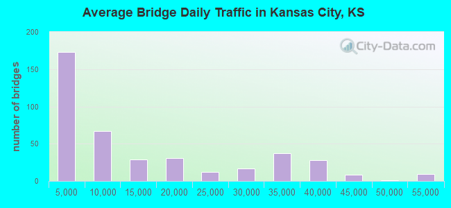
- 5,618,230Total average daily traffic
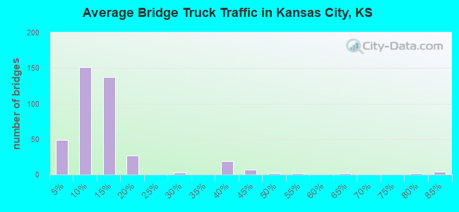
- 657,012Total average daily truck traffic
- National Bridge Inventory (NBI) Registered Bridges for Kansas City
- No street view available for this location
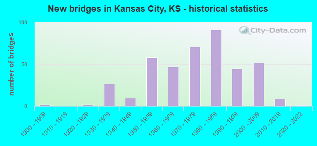
- New bridges - historical statistics
- 21900-1909
- 21920-1929
- 271930-1939
- 101940-1949
- 581950-1959
- 471960-1969
- 711970-1979
- 911980-1989
- 451990-1999
- 522000-2009
- 92010-2019
- 12020-2022
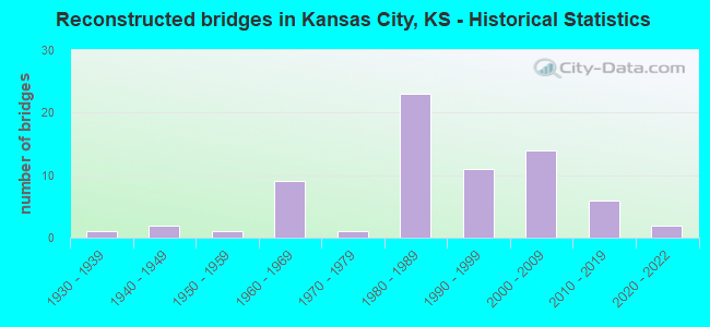
- Reconstructed bridges - Historical Statistics
- 11930-1939
- 21940-1949
- 11950-1959
- 91960-1969
- 11970-1979
- 231980-1989
- 111990-1999
- 142000-2009
- 62010-2019
- 22020-2022
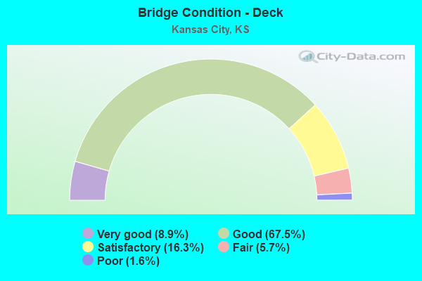
- Bridge Condition - Deck
- 8.9%Very good
- 67.5%Good
- 16.3%Satisfactory
- 5.7%Fair
- 1.6%Poor
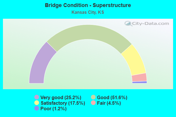
- Bridge Condition - Superstructure
- 25.2%Very good
- 51.6%Good
- 17.5%Satisfactory
- 4.5%Fair
- 1.2%Poor
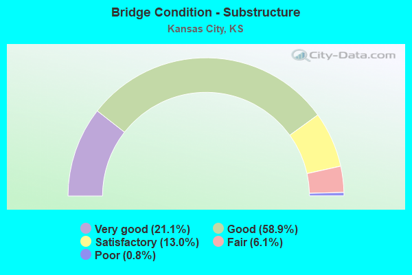
- Bridge Condition - Substructure
- 21.1%Very good
- 58.9%Good
- 13.0%Satisfactory
- 6.1%Fair
- 0.8%Poor
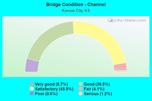
- Bridge Condition - Channel
- 8.7%Very good
- 39.5%Good
- 45.9%Satisfactory
- 4.1%Fair
- 0.6%Poor
- 1.2%Serious
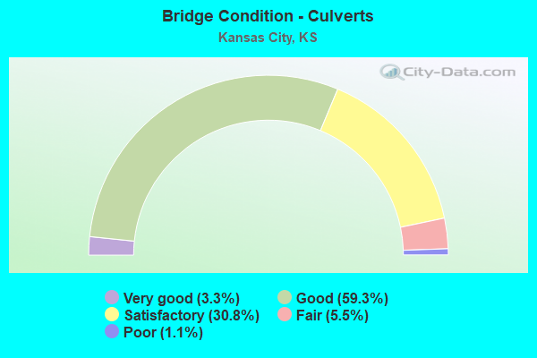
- Bridge Condition - Culverts
- 3.3%Very good
- 59.3%Good
- 30.8%Satisfactory
- 5.5%Fair
- 1.1%Poor
Find on map >> Show street view
Structure Number: 514301050000346, Location: WB TURNER TO SB KAW DR. (Lat: 39.098500, Lng: -94.722058), Route carried "on" structure: City street , Year Built: 1960, Status: Open, Structure Length: 4.63m (15.19ft), Average Daily Traffic: 6,500 (year 1989), Truck Traffic: 15%, Average Future Daily Traffic: 7,800 (year 2043), Design Load: H 20, Features Intersected: KAW DRIVE (SOUTH-BOUND), Facility Carried by Structure: RAMP TO TURNER DIA
Minimum Vertical Clearance: 30.47m (99.97ft), Kilometerpoint: 0.000, Lanes on structure: 2, Lanes under structure: 2, Owner: County Highway Agency, Approaching Roadway Width: 8.5m (27.9ft), Material/Design: Concrete continuous, Design/Construction: Box Beam or Girders - Multiple, Number Of Spans In Main Unit: 3, Length of Maximum Span: 18.0m (59.1ft), Curb-To-Curb Width: 8.5m (27.9ft), Out-to-Out Width: 9.4m (30.8ft)
Condition: Deck: Satisfactory, Superstructure: Satisfactory, Substructure: Satisfactory, Operating Rating: 48.6 metric tons, Method Used To Determine Operating Rating: Load Factor (LF), Inventory Rating: 29.1 metric tons, Method Used To Determine Inventory Rating: Load Factor (LF), Structural Evaluation: Equal to present minimum criteria, Deck Geometry: High priority of corrective action, Underclear: High priority of corrective action, Approach Roadway Alignment: Equal to present desirable criteria, Length Of Structure Improvement: 36.58m (120.01ft), Designated Inspection Frequency: Every 24 months, Inspection Date: March 2021, Other Special Inspection Date: Febuary 2019, Bridge Improvement Cost: $1,000, Total Project Cost: $2,000 ( Estimate for 2015), Deck Structure Type: Concrete Cast-file-Place, Wearing Surface/Protective System: Wearing Surface: Integral Concrete
Find on map >> Show street view
Structure Number: 514301050000359, Location: THORN DR N OF DOUGLAS AVE (Lat: 39.073692, Lng: -94.733069), Route carried "on" structure: City street , Year Built: 1970, Status: Posted for load, Structure Length: 1.31m (4.30ft), Average Daily Traffic: 5 (year 2015), Truck Traffic: 80%, Average Future Daily Traffic: 100 (year 2043), Design Load: HS 20, Features Intersected: STREAM, Facility Carried by Structure: THORN DRIVE
Minimum Vertical Clearance: 30.47m (99.97ft), Kilometerpoint: 0.000, Lanes on structure: 2, Owner: County Highway Agency, Approaching Roadway Width: 6.0m (19.7ft), Material/Design: Wood or Timber, Design/Construction: Stringer/Multi-beam, Number Of Spans In Main Unit: 3, Length of Maximum Span: 4.6m (15.1ft), Curb-To-Curb Width: 5.9m (19.4ft), Out-to-Out Width: 6.6m (21.7ft)
Condition: Deck: Satisfactory, Superstructure: Satisfactory, Substructure: Fair, Channel: Satisfactory, Operating Rating: 27.2 metric tons, Method Used To Determine Operating Rating: Allowable Stress (AS), Inventory Rating: 20.4 metric tons, Method Used To Determine Inventory Rating: Allowable Stress (AS), Structural Evaluation: Somewhat better than minimum adequacy, Deck Geometry: Meets minimum limits, Waterway Adequacy: Equal to present minimum criteria, Approach Roadway Alignment: Meets minimum limits, Bridge Posting: Required (Relationship of Operating Rating to Maximum Legal Load: 20.0 - 29.9% below), Length Of Structure Improvement: 1.98m (6.50ft), Designated Inspection Frequency: Every 24 months, Inspection Date: March 2021, Other Special Inspection Date: November 2020, Bridge Improvement Cost: $196,000, Roadway Improvement Cost: $108,000, Total Project Cost: $356,000, Deck Structure Type: Wood or Timber, Wearing Surface/Protective System: Wearing Surface: Other, Deck Protection: Other
Find on map >> Show street view
Structure Number: 51430105000036, Location: DOUGLAS AVE E OF THORN DR (Lat: 39.065800, Lng: -94.744208), Route carried "on" structure: City street , Year Built: 1970, Status: Posted for load, Structure Length: 2.13m (6.99ft), Average Daily Traffic: 1,500 (year 1993), Truck Traffic: 75%, Average Future Daily Traffic: 2,250 (year 2043), Design Load: HS 20, Features Intersected: STREAM, Facility Carried by Structure: DOUGLAS AVENUE
Minimum Vertical Clearance: 4.16m (13.65ft), Kilometerpoint: 0.000, Lanes on structure: 2, Owner: County Highway Agency, Approaching Roadway Width: 5.4m (17.7ft), Skew: 3 degrees, Material/Design: Wood or Timber, Design/Construction: Stringer/Multi-beam, Number Of Spans In Main Unit: 5, Length of Maximum Span: 4.3m (14.1ft), Curb-To-Curb Width: 7.1m (23.3ft), Out-to-Out Width: 7.7m (25.3ft)
Condition: Deck: Good, Superstructure: Good, Substructure: Good, Channel: Good, Operating Rating: 30.8 metric tons, Method Used To Determine Operating Rating: Allowable Stress (AS), Inventory Rating: 21.8 metric tons, Method Used To Determine Inventory Rating: Allowable Stress (AS), Structural Evaluation: Somewhat better than minimum adequacy, Deck Geometry: High priority of corrective action, Waterway Adequacy: Somewhat better than minimum adequacy, Approach Roadway Alignment: Equal to present minimum criteria, Length Of Structure Improvement: 1.37m (4.49ft), Designated Inspection Frequency: Every 24 months, Inspection Date: March 2021, Bridge Improvement Cost: $106,000, Roadway Improvement Cost: $65,000, Total Project Cost: $208,000, Deck Structure Type: Wood or Timber, Wearing Surface/Protective System: Wearing Surface: Other, Deck Protection: Other
Find on map >> Show street view
Structure Number: 514301050000382, Location: CANAAN CREEK SUBDIVISION (Lat: 39.145008, Lng: -94.843875), Route carried "on" structure: City street , Year Built: 2004, Status: Open, Structure Length: 0.98m (3.22ft), Average Daily Traffic: 150 (year 2004), Truck Traffic: 5%, Average Future Daily Traffic: 300 (year 2043), Design Load: HS 20, Features Intersected: STREAM, Facility Carried by Structure: PARKVIEW
Minimum Vertical Clearance: 30.47m (99.97ft), Kilometerpoint: 0.000, Lanes on structure: 2, Owner: County Highway Agency, Approaching Roadway Width: 8.5m (27.9ft), Material/Design: Concrete, Design/Construction: Culvert, Number Of Spans In Main Unit: 1, Length of Maximum Span: 9.8m (32.2ft)
Condition: Channel: Satisfactory, Culverts: Good, Operating Rating: 54.0 metric tons, Method Used To Determine Operating Rating: Load Factor (LF), Inventory Rating: 32.4 metric tons, Method Used To Determine Inventory Rating: Load Factor (LF), Structural Evaluation: Better than present minimum criteria, Waterway Adequacy: Better than present minimum criteria, Approach Roadway Alignment: Equal to present desirable criteria, Designated Inspection Frequency: Every 24 months, Inspection Date: March 2021
Find on map >> Show street view
Structure Number: 514301050000383, Location: Whispering Ridge Sub. (Lat: 39.155261, Lng: -94.834714), Route carried "on" structure: City street , Year Built: 2005, Status: Open, Structure Length: 1.10m (3.61ft), Average Daily Traffic: 150 (year 2005), Truck Traffic: 1%, Average Future Daily Traffic: 300 (year 2043), Design Load: HL 93, Features Intersected: Connor Creek, Facility Carried by Structure: Whispering Drive
Minimum Vertical Clearance: 30.47m (99.97ft), Kilometerpoint: 0.000, Lanes on structure: 2, Owner: County Highway Agency, Approaching Roadway Width: 8.5m (27.9ft), Skew: 1 degrees, Material/Design: Concrete, Design/Construction: Culvert, Number Of Spans In Main Unit: 1, Length of Maximum Span: 11.0m (36.1ft), Curb or Sidewalk Widths: Left: 1.5m (4.9ft), Right: 0.0m
Condition: Channel: Good, Culverts: Good, Operating Rating: 56.2 metric tons, Method Used To Determine Operating Rating: Load Factor (LF), Inventory Rating: 33.7 metric tons, Method Used To Determine Inventory Rating: Load Factor (LF), Structural Evaluation: Better than present minimum criteria, Waterway Adequacy: Equal to present desirable criteria, Approach Roadway Alignment: Equal to present desirable criteria, Designated Inspection Frequency: Every 24 months, Inspection Date: March 2021, Other Special Inspection Date: Febuary 2019
Find on map >> Show street view
Structure Number: 514301050000384, Location: Whispering Ridge Sub. (Lat: 39.153000, Lng: -94.835486), Route carried "on" structure: City street , Year Built: 2005, Status: Open, Structure Length: 1.10m (3.61ft), Average Daily Traffic: 150 (year 2005), Truck Traffic: 1%, Average Future Daily Traffic: 300 (year 2043), Design Load: HS 20, Features Intersected: Connor Creek, Facility Carried by Structure: Whispering Drive
Minimum Vertical Clearance: 30.47m (99.97ft), Kilometerpoint: 0.000, Lanes on structure: 2, Owner: County Highway Agency, Approaching Roadway Width: 8.0m (26.2ft), Material/Design: Concrete, Design/Construction: Culvert, Number Of Spans In Main Unit: 1, Length of Maximum Span: 11.0m (36.1ft), Curb or Sidewalk Widths: Left: 1.2m (3.9ft), Right: 1.2m (3.9ft)
Condition: Channel: Good, Culverts: Good, Operating Rating: 40.2 metric tons, Method Used To Determine Operating Rating: Load Factor (LF), Inventory Rating: 24.0 metric tons, Method Used To Determine Inventory Rating: Load Factor (LF), Structural Evaluation: Equal to present minimum criteria, Waterway Adequacy: Equal to present desirable criteria, Approach Roadway Alignment: Equal to present minimum criteria, Designated Inspection Frequency: Every 24 months, Inspection Date: March 2021, Other Special Inspection Date: November 2020
Find on map >> Show street view
Structure Number: 514301050000391, Location: N of Southwest Blvd (Lat: 39.059322, Lng: -94.626403), Route carried "on" structure: ServiceCity street , Year Built: 2011, Status: Open, Structure Length: 3.05m (10.01ft), Average Daily Traffic: 200 (year 2012), Truck Traffic: 40%, Average Future Daily Traffic: 300 (year 2043), Design Load: HS 20, Features Intersected: Turkey Creek, Facility Carried by Structure: Turkey Creek Acces
Minimum Vertical Clearance: 7.10m (23.29ft), Kilometerpoint: 0.000, Lanes on structure: 2, Owner: County Highway Agency, Approaching Roadway Width: 8.5m (27.9ft), Material/Design: Steel, Design/Construction: Stringer/Multi-beam, Number Of Spans In Main Unit: 1, Length of Maximum Span: 29.0m (95.1ft), Curb-To-Curb Width: 8.5m (27.9ft), Out-to-Out Width: 9.4m (30.8ft)
Condition: Deck: Good, Superstructure: Very good, Substructure: Satisfactory, Channel: Satisfactory, Operating Rating: 42.4 metric tons, Method Used To Determine Operating Rating: Load and Resistance Factor Rating (LRFR) rating reported by rating factor(RF) method using HL-93 loadings, Inventory Rating: 32.7 metric tons, Method Used To Determine Inventory Rating: Load and Resistance Factor Rating (LRFR) rating reported by rating factor(RF) method using HL-93 loadings, Structural Evaluation: Equal to present minimum criteria, Deck Geometry: Equal to present minimum criteria, Waterway Adequacy: Equal to present desirable criteria, Approach Roadway Alignment: Equal to present desirable criteria, Designated Inspection Frequency: Every 24 months, Inspection Date: March 2021, Deck Structure Type: Concrete Cast-file-Place, Wearing Surface/Protective System: Deck Protection: Epoxy Coated Reinforcing
Find on map >> Show street view
Structure Number: 514301050000392, Location: 4030 N. 55TH. ST. (Lat: 39.160361, Lng: -94.703194), Route carried "on" structure: City street 6847, Year Built: 2013, Status: Open, Structure Length: 0.64m (2.10ft), Average Daily Traffic: 819 (year 1992), Truck Traffic: 50%, Average Future Daily Traffic: 825 (year 2043), Design Load: HS 20, Features Intersected: NEARMAN CREEK, Facility Carried by Structure: 55th STREET
Minimum Vertical Clearance: 30.47m (99.97ft), Kilometerpoint: 0.000, Lanes on structure: 2, Owner: County Highway Agency, Approaching Roadway Width: 6.7m (22.0ft), Skew: 3 degrees, Material/Design: Concrete, Design/Construction: Culvert, Number Of Spans In Main Unit: 1, Length of Maximum Span: 6.4m (21.0ft), Curb-To-Curb Width: 14.0m (45.9ft), Out-to-Out Width: 14.8m (48.6ft)
Condition: Channel: Good, Culverts: Very good, Operating Rating: 54.4 metric tons, Method Used To Determine Operating Rating: Load Factor (LF), Inventory Rating: 32.7 metric tons, Method Used To Determine Inventory Rating: Load Factor (LF), Structural Evaluation: Equal to present desirable criteria, Deck Geometry: Superior to present desirable criteria, Waterway Adequacy: Better than present minimum criteria, Approach Roadway Alignment: Equal to present desirable criteria, Designated Inspection Frequency: Every 24 months, Inspection Date: March 2021, Deck Structure Type: Concrete Cast-file-Place, Wearing Surface/Protective System: Wearing Surface: Monolithic Concrete
Find on map >> Show street view
Structure Number: 514301050000393, Location: 4115 N. 55TH. ST. (Lat: 39.162361, Lng: -94.700000), Route carried "on" structure: City street 6847, Year Built: 2013, Status: Open, Structure Length: 0.87m (2.85ft), Average Daily Traffic: 786 (year 1992), Truck Traffic: 50%, Average Future Daily Traffic: 790 (year 2043), Design Load: HS 20, Features Intersected: NEARMAN CREEK, Facility Carried by Structure: 55th STREET
Minimum Vertical Clearance: 30.47m (99.97ft), Kilometerpoint: 0.000, Lanes on structure: 2, Owner: County Highway Agency, Approaching Roadway Width: 6.4m (21.0ft), Material/Design: Concrete, Design/Construction: Culvert, Number Of Spans In Main Unit: 2, Length of Maximum Span: 4.3m (14.1ft), Curb-To-Curb Width: 14.0m (45.9ft), Out-to-Out Width: 14.7m (48.2ft)
Condition: Channel: Good, Culverts: Very good, Operating Rating: 54.4 metric tons, Method Used To Determine Operating Rating: Load Factor (LF), Inventory Rating: 32.7 metric tons, Method Used To Determine Inventory Rating: Load Factor (LF), Structural Evaluation: Equal to present desirable criteria, Deck Geometry: Superior to present desirable criteria, Waterway Adequacy: Better than present minimum criteria, Approach Roadway Alignment: Equal to present desirable criteria, Designated Inspection Frequency: Every 24 months, Inspection Date: March 2021, Deck Structure Type: Concrete Cast-file-Place, Wearing Surface/Protective System: Wearing Surface: Monolithic Concrete
Find on map >> Show street view
Structure Number: 51430105000140A, Location: MILL ST. N. OF SEMINARY (Lat: 39.055269, Lng: -94.630494), Route carried "on" structure: County highway , Year Built: 2013, Status: Open, Structure Length: 2.96m (9.71ft), Average Daily Traffic: 1,279 (year 1991), Truck Traffic: 5%, Average Future Daily Traffic: 1,500 (year 2043), Design Load: HL 93, Features Intersected: TURKEY CREEK, Facility Carried by Structure: MILL STREET
Minimum Vertical Clearance: 4.49m (14.73ft), Kilometerpoint: 0.000, Lanes on structure: 2, Owner: County Highway Agency, Approaching Roadway Width: 8.5m (27.9ft), Material/Design: Concrete continuous, Design/Construction: Slab, Number Of Spans In Main Unit: 2, Length of Maximum Span: 14.3m (46.9ft), Curb or Sidewalk Widths: Left: 0.5m (1.6ft), Right: 2.0m (6.6ft), Curb-To-Curb Width: 8.5m (27.9ft), Out-to-Out Width: 11.1m (36.4ft)
Condition: Deck: Good, Superstructure: Good, Substructure: Very good, Channel: Good, Operating Rating: 78.1 metric tons, Method Used To Determine Operating Rating: Load and Resistance Factor Rating (LRFR) rating reported by rating factor(RF) method using HL-93 loadings, Inventory Rating: 60.3 metric tons, Method Used To Determine Inventory Rating: Load and Resistance Factor Rating (LRFR) rating reported by rating factor(RF) method using HL-93 loadings, Structural Evaluation: Better than present minimum criteria, Deck Geometry: Somewhat better than minimum adequacy, Waterway Adequacy: Better than present minimum criteria, Approach Roadway Alignment: Meets minimum limits, Designated Inspection Frequency: Every 24 months, Inspection Date: March 2021, Deck Structure Type: Concrete Cast-file-Place, Wearing Surface/Protective System: Deck Protection: Epoxy Coated Reinforcing
Find on map >> Show street view
Structure Number: 999900500520681, Location: 1.25 MI NW WYANDOTTE COLN (Lat: 39.215556, Lng: -94.842222), Route carried "on" structure: State highway 5, Year Built: 1992, Status: Open, Structure Length: 1.12m (3.67ft), Average Daily Traffic: 2,285 (year 2020), Truck Traffic: 12%, Average Future Daily Traffic: 3,970 (year 2041), Design Load: HS 20, Features Intersected: LITTLE SNELL CREEK
Minimum Vertical Clearance: 30.47m (99.97ft), Kilometerpoint: 2.004, Lanes on structure: 2, Owner: State Highway Agency, Approaching Roadway Width: 7.3m (24.0ft), Skew: 3 degrees, Material/Design: Concrete, Design/Construction: Culvert, Number Of Spans In Main Unit: 2, Length of Maximum Span: 4.9m (16.1ft), Curb-To-Curb Width: 16.1m (52.8ft), Out-to-Out Width: 16.5m (54.1ft)
Condition: Channel: Good, Culverts: Good, Inventory Rating: 12.2 metric tons, Method Used To Determine Inventory Rating: Load Factor (LF), Structural Evaluation: High priority of corrective action, Deck Geometry: Superior to present desirable criteria, Waterway Adequacy: Better than present minimum criteria, Approach Roadway Alignment: High priority of replacement, Length Of Structure Improvement: 3.67m (12.04ft), Designated Inspection Frequency: Every 24 months, Inspection Date: June 2021, Deck Structure Type: Concrete Cast-file-Place, Wearing Surface/Protective System: Wearing Surface: Bituminous
Find on map >> Show street view
Structure Number: 999900501051861, Location: 0.50 MILES E I-635 (Lat: 39.143889, Lng: -94.650833), Route carried "on" structure: State highway 5, Year Built: 1977, Status: Open, Structure Length: 5.14m (16.86ft), Average Daily Traffic: 3,485 (year 2020), Truck Traffic: 14%, Average Future Daily Traffic: 4,007 (year 2041), Design Load: HS 20, Features Intersected: 18TH ST
Minimum Vertical Clearance: 30.47m (99.97ft), Kilometerpoint: 2.839, Lanes on structure: 2, Lanes under structure: 4, Base Highway Network: Yes, Owner: State Highway Agency, Approaching Roadway Width: 12.2m (40.0ft), Material/Design: Steel continuous, Design/Construction: Stringer/Multi-beam, Number Of Spans In Main Unit: 3, Length of Maximum Span: 23.5m (77.1ft), Curb-To-Curb Width: 12.2m (40.0ft), Out-to-Out Width: 12.8m (42.0ft)
Condition: Deck: Satisfactory, Superstructure: Good, Substructure: Good, Operating Rating: 55.3 metric tons, Method Used To Determine Operating Rating: Load Factor (LF), Inventory Rating: 33.6 metric tons, Method Used To Determine Inventory Rating: Load Factor (LF), Structural Evaluation: Better than present minimum criteria, Deck Geometry: Better than present minimum criteria, Underclear: Meets minimum limits, Approach Roadway Alignment: Somewhat better than minimum adequacy, Length Of Structure Improvement: 16.86m (55.31ft), Designated Inspection Frequency: Every 24 months, Inspection Date: June 2021, Deck Structure Type: Concrete Cast-file-Place, Wearing Surface/Protective System: Wearing Surface: Low Slump Concrete
Find on map >> Show street view
Structure Number: 999900501051871, Location: 0.51 MILES E I-635 (Lat: 39.144167, Lng: -94.650833), Route carried "on" structure: State highway 5, Year Built: 1977, Status: Open, Structure Length: 5.14m (16.86ft), Average Daily Traffic: 3,485 (year 2020), Truck Traffic: 14%, Average Future Daily Traffic: 4,007 (year 2041), Design Load: HS 20, Features Intersected: 18TH STREET
Minimum Vertical Clearance: 30.47m (99.97ft), Kilometerpoint: 2.816, Lanes on structure: 2, Lanes under structure: 4, Base Highway Network: Yes, Owner: State Highway Agency, Approaching Roadway Width: 11.0m (36.1ft), Material/Design: Steel continuous, Design/Construction: Stringer/Multi-beam, Number Of Spans In Main Unit: 3, Length of Maximum Span: 23.5m (77.1ft), Curb-To-Curb Width: 12.2m (40.0ft), Out-to-Out Width: 12.8m (42.0ft)
Condition: Deck: Satisfactory, Superstructure: Good, Substructure: Very good, Operating Rating: 53.5 metric tons, Method Used To Determine Operating Rating: Load Factor (LF), Inventory Rating: 32.7 metric tons, Method Used To Determine Inventory Rating: Load Factor (LF), Structural Evaluation: Better than present minimum criteria, Deck Geometry: Better than present minimum criteria, Underclear: Meets minimum limits, Approach Roadway Alignment: Equal to present desirable criteria, Length Of Structure Improvement: 16.86m (55.31ft), Designated Inspection Frequency: Every 24 months, Inspection Date: June 2021, Deck Structure Type: Concrete Cast-file-Place, Wearing Surface/Protective System: Wearing Surface: Low Slump Concrete
Find on map >> Show street view
Structure Number: 999900501051901, Location: 1.08 MILES E I-635 (Lat: 39.141944, Lng: -94.640556), Route carried "on" structure: ServiceCity street 88, Year Built: 1977, Status: Open, Structure Length: 6.79m (22.28ft), Average Daily Traffic: 528 (year 2020), Truck Traffic: 1%, Average Future Daily Traffic: 3,967 (year 2041), Design Load: HS 20, Features Intersected: K-5 HIGHWAY, Facility Carried by Structure: 12TH STREET
Minimum Vertical Clearance: 30.47m (99.97ft), Kilometerpoint: 0.882, Lanes on structure: 2, Lanes under structure: 4, Owner: State Highway Agency, Approaching Roadway Width: 7.3m (24.0ft), Skew: 2 degrees, Material/Design: Concrete continuous, Design/Construction: Box Beam or Girders - Multiple, Number Of Spans In Main Unit: 4, Length of Maximum Span: 20.1m (65.9ft), Curb or Sidewalk Widths: Left: 1.2m (3.9ft), Right: 1.2m (3.9ft), Curb-To-Curb Width: 9.1m (29.9ft), Out-to-Out Width: 9.8m (32.2ft)
Condition: Deck: Good, Superstructure: Good, Substructure: Good, Operating Rating: 68.5 metric tons, Method Used To Determine Operating Rating: Load Factor (LF), Inventory Rating: 41.0 metric tons, Method Used To Determine Inventory Rating: Load Factor (LF), Structural Evaluation: Better than present minimum criteria, Deck Geometry: Equal to present minimum criteria, Underclear: Somewhat better than minimum adequacy, Approach Roadway Alignment: Somewhat better than minimum adequacy, Length Of Structure Improvement: 22.27m (73.06ft), Designated Inspection Frequency: Every 24 months, Inspection Date: June 2021, Deck Structure Type: Concrete Cast-file-Place, Wearing Surface/Protective System: Wearing Surface: Low Slump Concrete
Find on map >> Show street view
Structure Number: 999900501051911, Location: 0.96 MI W OF US69 HWY (Lat: 39.141111, Lng: -94.636944), Route carried "on" structure: ServiceCity street 943, Year Built: 1976, Status: Open, Structure Length: 5.20m (17.06ft), Average Daily Traffic: 528 (year 2020), Truck Traffic: 1%, Average Future Daily Traffic: 3,967 (year 2041), Design Load: HS 20, Features Intersected: K-5 HIGHWAY, Facility Carried by Structure: PARKWOOD STREET
Minimum Vertical Clearance: 30.47m (99.97ft), Kilometerpoint: 0.098, Lanes on structure: 2, Lanes under structure: 4, Owner: State Highway Agency, Approaching Roadway Width: 9.1m (29.9ft), Material/Design: Concrete continuous, Design/Construction: Slab, Number Of Spans In Main Unit: 4, Length of Maximum Span: 15.5m (50.9ft), Curb or Sidewalk Widths: Left: 1.2m (3.9ft), Right: 1.2m (3.9ft), Curb-To-Curb Width: 9.1m (29.9ft), Out-to-Out Width: 9.8m (32.2ft)
Condition: Deck: Fair, Superstructure: Good, Substructure: Good, Operating Rating: 45.4 metric tons, Method Used To Determine Operating Rating: Load Factor (LF), Inventory Rating: 27.2 metric tons, Method Used To Determine Inventory Rating: Load Factor (LF), Structural Evaluation: Equal to present minimum criteria, Deck Geometry: Equal to present minimum criteria, Underclear: Meets minimum limits, Approach Roadway Alignment: Somewhat better than minimum adequacy, Length Of Structure Improvement: 17.05m (55.94ft), Designated Inspection Frequency: Every 24 months, Inspection Date: June 2021, Deck Structure Type: Concrete Cast-file-Place, Wearing Surface/Protective System: Wearing Surface: Monolithic Concrete
Find on map >> Show street view
Structure Number: 999900501051921, Location: 0.83 MI W OF US69 (Lat: 39.141944, Lng: -94.634722), Route carried "on" structure: State highway 5, Year Built: 1976, Status: Open, Structure Length: 7.66m (25.13ft), Average Daily Traffic: 3,485 (year 2020), Truck Traffic: 14%, Average Future Daily Traffic: 4,007 (year 2041), Design Load: HS 20, Features Intersected: 10TH STREET
Minimum Vertical Clearance: 30.47m (99.97ft), Kilometerpoint: 1.358, Lanes on structure: 4, Lanes under structure: 4, Base Highway Network: Yes, Owner: State Highway Agency, Approaching Roadway Width: 22.7m (74.5ft), Skew: 23 degrees, Material/Design: Concrete continuous, Design/Construction: Box Beam or Girders - Multiple, Number Of Spans In Main Unit: 3, Length of Maximum Span: 33.5m (109.9ft), Curb-To-Curb Width: 22.7m (74.5ft), Out-to-Out Width: 24.2m (79.4ft)
Condition: Deck: Satisfactory, Superstructure: Satisfactory, Substructure: Good, Operating Rating: 70.0 metric tons, Method Used To Determine Operating Rating: Load Factor (LF), Inventory Rating: 42.0 metric tons, Method Used To Determine Inventory Rating: Load Factor (LF), Structural Evaluation: Equal to present minimum criteria, Deck Geometry: Superior to present desirable criteria, Underclear: Equal to present minimum criteria, Approach Roadway Alignment: Better than present minimum criteria, Length Of Structure Improvement: 25.13m (82.45ft), Designated Inspection Frequency: Every 24 months, Inspection Date: June 2021, Deck Structure Type: Concrete Cast-file-Place, Wearing Surface/Protective System: Wearing Surface: Low Slump Concrete
Find on map >> Show street view
Structure Number: 999900501051931, Location: 0.52 MI W OF US69 HWY (Lat: 39.144722, Lng: -94.630556), Route carried "on" structure: State highway 5, Year Built: 1976, Status: Open, Structure Length: 19.69m (64.60ft), Average Daily Traffic: 3,045 (year 2020), Truck Traffic: 14%, Average Future Daily Traffic: 3,501 (year 2041), Design Load: HS 20, Features Intersected: UP RR & LEVEE RD
Minimum Vertical Clearance: 30.47m (99.97ft), Kilometerpoint: 0.855, Lanes on structure: 4, Lanes under structure: 2, Base Highway Network: Yes, Owner: State Highway Agency, Approaching Roadway Width: 22.7m (74.5ft), Skew: 23 degrees, Material/Design: Steel continuous, Design/Construction: Stringer/Multi-beam, Number Of Spans In Main Unit: 6, Length of Maximum Span: 44.5m (146.0ft), Curb-To-Curb Width: 22.7m (74.5ft), Out-to-Out Width: 24.1m (79.1ft)
Condition: Deck: Poor, Superstructure: Fair, Substructure: Fair, Operating Rating: 55.6 metric tons, Method Used To Determine Operating Rating: Load Factor (LF), Inventory Rating: 33.3 metric tons, Method Used To Determine Inventory Rating: Load Factor (LF), Structural Evaluation: Somewhat better than minimum adequacy, Deck Geometry: Superior to present desirable criteria, Underclear: Superior to present desirable criteria, Approach Roadway Alignment: Better than present minimum criteria, Length Of Structure Improvement: 64.60m (211.94ft), Designated Inspection Frequency: Every 24 months, Inspection Date: June 2021, Deck Structure Type: Concrete Cast-file-Place, Wearing Surface/Protective System: Wearing Surface: Epoxy Overlay
Find on map >> Show street view
Structure Number: 999900501052321, Location: 0.55 MI N I435 (Lat: 39.186111, Lng: -94.802778), Route carried "on" structure: State highway 5, Year Built: 1985, Status: Open, Structure Length: 4.04m (13.25ft), Average Daily Traffic: 3,465 (year 2020), Truck Traffic: 8%, Average Future Daily Traffic: 6,506 (year 2041), Design Load: HS 20, Features Intersected: CONNOR CREEK
Minimum Vertical Clearance: 30.47m (99.97ft), Kilometerpoint: 23.397, Lanes on structure: 2, Owner: State Highway Agency, Approaching Roadway Width: 13.4m (44.0ft), Material/Design: Concrete continuous, Design/Construction: Slab, Number Of Spans In Main Unit: 3, Length of Maximum Span: 15.8m (51.8ft), Curb-To-Curb Width: 13.4m (44.0ft), Out-to-Out Width: 14.2m (46.6ft)
Condition: Deck: Good, Superstructure: Good, Substructure: Very good, Channel: Good, Operating Rating: 57.2 metric tons, Method Used To Determine Operating Rating: Load Factor (LF), Inventory Rating: 34.5 metric tons, Method Used To Determine Inventory Rating: Load Factor (LF), Structural Evaluation: Better than present minimum criteria, Deck Geometry: Better than present minimum criteria, Waterway Adequacy: Equal to present minimum criteria, Approach Roadway Alignment: Meets minimum limits, Length Of Structure Improvement: 13.25m (43.47ft), Designated Inspection Frequency: Every 24 months, Inspection Date: June 2021, Wearing Surface/Protective System: Wearing Surface: Low Slump Concrete, Deck Protection: Epoxy Coated Reinforcing
Find on map >> Show street view
Structure Number: 999900501052651, Location: 0.39 MI SE OF LVNWTH CLN (Lat: 39.201111, Lng: -94.821111), Route carried "on" structure: State highway 5, Year Built: 1985, Status: Open, Structure Length: 4.44m (14.57ft), Average Daily Traffic: 2,285 (year 2020), Truck Traffic: 12%, Average Future Daily Traffic: 3,970 (year 2041), Design Load: HS 20+Mod, Features Intersected: ISLAND CREEK
Minimum Vertical Clearance: 30.47m (99.97ft), Kilometerpoint: 26.068, Lanes on structure: 2, Owner: State Highway Agency, Approaching Roadway Width: 8.5m (27.9ft), Skew: 2 degrees, Material/Design: Steel continuous, Design/Construction: Stringer/Multi-beam, Number Of Spans In Main Unit: 3, Length of Maximum Span: 17.4m (57.1ft), Curb-To-Curb Width: 8.5m (27.9ft), Out-to-Out Width: 9.1m (29.9ft)
Condition: Deck: Good, Superstructure: Good, Substructure: Good, Channel: Very good, Operating Rating: 68.1 metric tons, Method Used To Determine Operating Rating: Load Factor (LF), Inventory Rating: 40.8 metric tons, Method Used To Determine Inventory Rating: Load Factor (LF), Structural Evaluation: Better than present minimum criteria, Deck Geometry: Meets minimum limits, Waterway Adequacy: Equal to present desirable criteria, Approach Roadway Alignment: Meets minimum limits, Length Of Structure Improvement: 14.58m (47.83ft), Designated Inspection Frequency: Every 24 months, Inspection Date: June 2021, Wearing Surface/Protective System: Wearing Surface: Low Slump Concrete, Deck Protection: Epoxy Coated Reinforcing
Find on map >> Show street view
Structure Number: 999900501052851, Location: 1.49 MI E OF I-435 (Lat: 39.143056, Lng: -94.791667), Route carried "on" structure: State highway 5, Year Built: 1989, Status: Open, Structure Length: 0.86m (2.82ft), Average Daily Traffic: 5,788 (year 2020), Truck Traffic: 5%, Average Future Daily Traffic: 7,204 (year 2041), Design Load: HS 20, Features Intersected: MARSHALL CREEK
Minimum Vertical Clearance: 30.47m (99.97ft), Kilometerpoint: 15.305, Lanes on structure: 4, Owner: State Highway Agency, Approaching Roadway Width: 15.8m (51.8ft), Material/Design: Concrete, Design/Construction: Culvert, Number Of Spans In Main Unit: 3, Length of Maximum Span: 2.7m (8.9ft), Curb-To-Curb Width: 15.8m (51.8ft), Out-to-Out Width: 64.5m (211.6ft)
Condition: Channel: Satisfactory, Culverts: Good, Operating Rating: 42.6 metric tons, Method Used To Determine Operating Rating: Load Factor (LF), Inventory Rating: 25.4 metric tons, Method Used To Determine Inventory Rating: Load Factor (LF), Structural Evaluation: Equal to present minimum criteria, Deck Geometry: Meets minimum limits, Waterway Adequacy: Better than present minimum criteria, Approach Roadway Alignment: Equal to present desirable criteria, Length Of Structure Improvement: 2.83m (9.28ft), Designated Inspection Frequency: Every 24 months, Inspection Date: June 2021, Deck Structure Type: Concrete Cast-file-Place, Wearing Surface/Protective System: Wearing Surface: Bituminous
Find on map >> Show street view
Structure Number: 999902401051751, Location: US-24 & I-70 WB JCT (Lat: 39.114842, Lng: -94.617208), Route carried "on" structure: City street 2540, Year Built: 1962, Status: Posted for load-capacity, Structure Length: 21.80m (71.52ft), Average Daily Traffic: 3,880 (year 2008), Truck Traffic: 4%, Average Future Daily Traffic: 6,483 (year 2043), Design Load: H 20, Features Intersected: MINNESOTA AVE & 1 RAMP, Facility Carried by Structure: STATE AVENUE WB
Minimum Vertical Clearance: 30.47m (99.97ft), Kilometerpoint: 0.000, Lanes on structure: 2, Lanes under structure: 5, Owner: County Highway Agency, Approaching Roadway Width: 9.1m (29.9ft), Material/Design: Steel continuous, Design/Construction: Girder and Floorbeam System, Number Of Spans In Main Unit: 8, Length of Maximum Span: 32.0m (105.0ft), Curb-To-Curb Width: 9.1m (29.9ft), Out-to-Out Width: 10.9m (35.8ft)
Condition: Deck: Satisfactory, Superstructure: Satisfactory, Substructure: Good, Operating Rating: 29.2 metric tons, Method Used To Determine Operating Rating: Load Factor (LF), Inventory Rating: 17.5 metric tons, Method Used To Determine Inventory Rating: Load Factor (LF), Structural Evaluation: Meets minimum limits, Deck Geometry: Meets minimum limits, Underclear: High priority of corrective action, Approach Roadway Alignment: High priority of replacement, Length Of Structure Improvement: 21.98m (72.11ft), Designated Inspection Frequency: Every 24 months, Critical Feature Inspection Frequency: Every 24 months, Inspection Date: March 2021, Critical Feature Inspection Date: July 2021, Bridge Improvement Cost: $498,000, Roadway Improvement Cost: $50,000, Total Project Cost: $746,000, Deck Structure Type: Concrete Cast-file-Place, Wearing Surface/Protective System: Wearing Surface: Low Slump Concrete
Find on map >> Show street view
Structure Number: 999902401051761, Location: US-24 & I-70 EB JCT (Lat: 39.114444, Lng: -94.616944), Route carried "on" structure: City street 2540, Year Built: 1962, Status: Open, Structure Length: 13.89m (45.57ft), Average Daily Traffic: 3,430 (year 2015), Truck Traffic: 4%, Average Future Daily Traffic: 6,000 (year 2043), Design Load: H 20, Features Intersected: MINNESOTA AVE & 1 RAMP, Facility Carried by Structure: STATE AVENUE EB
Minimum Vertical Clearance: 4.57m (14.99ft), Kilometerpoint: 696.794, Lanes on structure: 1, Lanes under structure: 3, Base Highway Network: Yes, Owner: County Highway Agency, Approaching Roadway Width: 9.1m (29.9ft), Material/Design: Steel continuous, Design/Construction: Girder and Floorbeam System, Number Of Spans In Main Unit: 8, Length of Maximum Span: 22.9m (75.1ft), Curb-To-Curb Width: 9.1m (29.9ft), Out-to-Out Width: 10.9m (35.8ft)
Condition: Deck: Fair, Superstructure: Satisfactory, Substructure: Good, Operating Rating: 42.6 metric tons, Method Used To Determine Operating Rating: Load Factor (LF), Inventory Rating: 25.5 metric tons, Method Used To Determine Inventory Rating: Load Factor (LF), Structural Evaluation: Equal to present minimum criteria, Deck Geometry: Meets minimum limits, Underclear: High priority of corrective action, Approach Roadway Alignment: Somewhat better than minimum adequacy, Length Of Structure Improvement: 13.89m (45.57ft), Designated Inspection Frequency: Every 24 months, Critical Feature Inspection Frequency: Every 24 months, Inspection Date: March 2021, Critical Feature Inspection Date: July 2021, Bridge Improvement Cost: $314,000, Roadway Improvement Cost: $31,000, Total Project Cost: $472,000, Deck Structure Type: Concrete Cast-file-Place, Wearing Surface/Protective System: Wearing Surface: Low Slump Concrete
Find on map >> Show street view
Structure Number: 999902401052961, Location: 4.14 MI E U-24/K-7 JCT (Lat: 39.120317, Lng: -94.823664), Route carried "on" structure: City street 2540, Year Built: 2000, Status: Open, Structure Length: 5.64m (18.50ft), Average Daily Traffic: 18,500 (year 2008), Truck Traffic: 4%, Average Future Daily Traffic: 28,000 (year 2043), Design Load: HS 25 or greater, Features Intersected: FRANCE FAMILY DRIVE, Facility Carried by Structure: STATE AVENUE
Minimum Vertical Clearance: 30.47m (99.97ft), Kilometerpoint: 0.000, Lanes on structure: 4, Lanes under structure: 4, Owner: County Highway Agency, Approaching Roadway Width: 21.0m (68.9ft), Material/Design: Prestressed concrete continuous, Design/Construction: Stringer/Multi-beam, Number Of Spans In Main Unit: 3, Length of Maximum Span: 28.0m (91.9ft), Curb-To-Curb Width: 20.7m (67.9ft), Out-to-Out Width: 21.5m (70.5ft)
Condition: Deck: Good, Superstructure: Very good, Substructure: Very good, Operating Rating: 76.2 metric tons, Method Used To Determine Operating Rating: Load Factor (LF), Inventory Rating: 45.4 metric tons, Method Used To Determine Inventory Rating: Load Factor (LF), Structural Evaluation: Equal to present desirable criteria, Deck Geometry: Superior to present desirable criteria, Underclear: Superior to present desirable criteria, Approach Roadway Alignment: Better than present minimum criteria, Designated Inspection Frequency: Every 24 months, Inspection Date: March 2021, Deck Structure Type: Concrete Precast Panels, Wearing Surface/Protective System: Wearing Surface: Low Slump Concrete
Find on map >> Show street view
Structure Number: 999903201050881, Location: 0.46 MILES E I-435 (Lat: 39.063056, Lng: -94.783333), Route carried "on" structure: ServiceCity street 360, Year Built: 1967, Status: Open, Structure Length: 0.63m (2.07ft), Average Daily Traffic: 528 (year 2020), Truck Traffic: 1%, Average Future Daily Traffic: 9,778 (year 2041), Design Load: H 20, Features Intersected: LITTLE TURKEY CR DRAIN, Facility Carried by Structure: 88TH STREET Left
Minimum Vertical Clearance: 30.47m (99.97ft), Kilometerpoint: 1.865, Lanes on structure: 2, Owner: State Highway Agency, Approaching Roadway Width: 9.8m (32.2ft), Material/Design: Concrete, Design/Construction: Culvert, Number Of Spans In Main Unit: 2, Length of Maximum Span: 3.0m (9.8ft), Curb-To-Curb Width: 10.7m (35.1ft), Out-to-Out Width: 11.4m (37.4ft)
Condition: Channel: Satisfactory, Culverts: Good, Operating Rating: 31.6 metric tons, Method Used To Determine Operating Rating: Load Factor (LF), Inventory Rating: 18.9 metric tons, Method Used To Determine Inventory Rating: Load Factor (LF), Structural Evaluation: Somewhat better than minimum adequacy, Deck Geometry: Equal to present minimum criteria, Waterway Adequacy: Better than present minimum criteria, Approach Roadway Alignment: Meets minimum limits, Length Of Structure Improvement: 2.07m (6.79ft), Designated Inspection Frequency: Every 24 months, Inspection Date: June 2021, Deck Structure Type: Concrete Cast-file-Place, Wearing Surface/Protective System: Wearing Surface: Monolithic Concrete
Find on map >> Show street view
Structure Number: 999903201050891, Location: 0.59 MILES E I-435 (Lat: 39.063611, Lng: -94.781111), Route carried "on" structure: ServiceOther road 1, Year Built: 1967, Status: Open, Structure Length: 0.63m (2.07ft), Truck Traffic: 1%, Design Load: H 20, Features Intersected: LITTLE TURKEY CR DRAIN, Facility Carried by Structure: ENTRANCE LEFT
Minimum Vertical Clearance: 30.47m (99.97ft), Kilometerpoint: 0.018, Lanes on structure: 1, Owner: State Highway Agency, Approaching Roadway Width: 7.3m (24.0ft), Material/Design: Concrete, Design/Construction: Culvert, Number Of Spans In Main Unit: 2, Length of Maximum Span: 3.0m (9.8ft), Curb-To-Curb Width: 7.3m (24.0ft), Out-to-Out Width: 7.8m (25.6ft)
Condition: Channel: Satisfactory, Culverts: Good, Operating Rating: 31.4 metric tons, Method Used To Determine Operating Rating: Load Factor (LF), Inventory Rating: 18.8 metric tons, Method Used To Determine Inventory Rating: Load Factor (LF), Structural Evaluation: Somewhat better than minimum adequacy, Deck Geometry: Equal to present minimum criteria, Waterway Adequacy: Equal to present minimum criteria, Approach Roadway Alignment: Somewhat better than minimum adequacy, Length Of Structure Improvement: 2.07m (6.79ft), Designated Inspection Frequency: Every 24 months, Inspection Date: June 2021, Deck Structure Type: Concrete Cast-file-Place, Wearing Surface/Protective System: Wearing Surface: Bituminous
Find on map >> Show street view
Structure Number: 999903201050901, Location: 0.73 MILES E I-435 (Lat: 39.064167, Lng: -94.778611), Route carried "on" structure: City street 2635, Year Built: 1965, Status: Open, Structure Length: 0.63m (2.07ft), Average Daily Traffic: 213 (year 2020), Truck Traffic: 6%, Average Future Daily Traffic: 310 (year 2041), Design Load: H 20, Features Intersected: LITTLE TURKEY CR DRAIN, Facility Carried by Structure: 86TH STREET NORTH
Minimum Vertical Clearance: 30.47m (99.97ft), Kilometerpoint: 0.031, Lanes on structure: 2, Owner: State Highway Agency, Approaching Roadway Width: 7.3m (24.0ft), Material/Design: Concrete, Design/Construction: Culvert, Number Of Spans In Main Unit: 2, Length of Maximum Span: 3.0m (9.8ft), Curb-To-Curb Width: 11.0m (36.1ft), Out-to-Out Width: 11.4m (37.4ft)
Condition: Channel: Satisfactory, Culverts: Good, Operating Rating: 31.7 metric tons, Method Used To Determine Operating Rating: Load Factor (LF), Inventory Rating: 19.0 metric tons, Method Used To Determine Inventory Rating: Load Factor (LF), Structural Evaluation: Somewhat better than minimum adequacy, Deck Geometry: Equal to present desirable criteria, Waterway Adequacy: Better than present minimum criteria, Approach Roadway Alignment: Somewhat better than minimum adequacy, Length Of Structure Improvement: 2.07m (6.79ft), Designated Inspection Frequency: Every 24 months, Inspection Date: June 2021, Deck Structure Type: Concrete Cast-file-Place, Wearing Surface/Protective System: Wearing Surface: Monolithic Concrete
Find on map >> Show street view
Structure Number: 999903201050911, Location: 0.81 MILES E I-435 (Lat: 39.064722, Lng: -94.777222), Route carried "on" structure: ServiceOther road 2, Year Built: 1967, Status: Open, Structure Length: 0.63m (2.07ft), Truck Traffic: 1%, Design Load: H 20, Features Intersected: LITTLE TURKEY CR DRAIN, Facility Carried by Structure: ENTRANCE LEFT
Minimum Vertical Clearance: 30.47m (99.97ft), Kilometerpoint: 0.016, Lanes on structure: 2, Owner: State Highway Agency, Approaching Roadway Width: 8.5m (27.9ft), Material/Design: Concrete, Design/Construction: Culvert, Number Of Spans In Main Unit: 2, Length of Maximum Span: 3.0m (9.8ft), Curb-To-Curb Width: 8.5m (27.9ft), Out-to-Out Width: 14.5m (47.6ft)
Condition: Channel: Satisfactory, Culverts: Good, Operating Rating: 39.2 metric tons, Method Used To Determine Operating Rating: Load Factor (LF), Inventory Rating: 23.5 metric tons, Method Used To Determine Inventory Rating: Load Factor (LF), Structural Evaluation: Equal to present minimum criteria, Deck Geometry: Better than present minimum criteria, Waterway Adequacy: Better than present minimum criteria, Approach Roadway Alignment: Somewhat better than minimum adequacy, Length Of Structure Improvement: 2.07m (6.79ft), Designated Inspection Frequency: Every 24 months, Inspection Date: June 2021, Deck Structure Type: Concrete Cast-file-Place, Wearing Surface/Protective System: Wearing Surface: Bituminous
Find on map >> Show street view
Structure Number: 999903201050921, Location: 0.91 MILES E I-435 (Lat: 39.065000, Lng: -94.775556), Route carried "on" structure: State highway 32, Year Built: 1928, Year Reconstructed: 1965, Status: Open, Structure Length: 0.84m (2.76ft), Average Daily Traffic: 8,940 (year 2020), Truck Traffic: 8%, Average Future Daily Traffic: 9,878 (year 2041), Design Load: H 15, Features Intersected: LITTLE TURKEY CR DRAIN
Minimum Vertical Clearance: 30.47m (99.97ft), Kilometerpoint: 12.028, Lanes on structure: 4, Base Highway Network: Yes, Owner: State Highway Agency, Approaching Roadway Width: 21.9m (71.9ft), Skew: 24 degrees, Material/Design: Concrete, Design/Construction: Culvert, Number Of Spans In Main Unit: 2, Length of Maximum Span: 3.0m (9.8ft), Curb-To-Curb Width: 21.9m (71.9ft), Out-to-Out Width: 32.0m (105.0ft)
Condition: Channel: Satisfactory, Culverts: Good, Operating Rating: 44.1 metric tons, Method Used To Determine Operating Rating: Load Factor (LF), Inventory Rating: 26.4 metric tons, Method Used To Determine Inventory Rating: Load Factor (LF), Structural Evaluation: Equal to present minimum criteria, Deck Geometry: Superior to present desirable criteria, Waterway Adequacy: Better than present minimum criteria, Approach Roadway Alignment: Better than present minimum criteria, Length Of Structure Improvement: 2.74m (8.99ft), Designated Inspection Frequency: Every 24 months, Inspection Date: June 2021, Deck Structure Type: Concrete Cast-file-Place, Wearing Surface/Protective System: Wearing Surface: Bituminous
Find on map >> Show street view
Structure Number: 999903201050931, Location: 1.20 MILES E I-435 (Lat: 39.067500, Lng: -94.771111), Route carried "on" structure: State highway 32, Year Built: 1967, Status: Open, Structure Length: 5.78m (18.96ft), Average Daily Traffic: 8,940 (year 2020), Truck Traffic: 8%, Average Future Daily Traffic: 9,878 (year 2041), Design Load: HS 20, Features Intersected: LITTLE TURKEY CREEK
Minimum Vertical Clearance: 30.47m (99.97ft), Kilometerpoint: 12.505, Lanes on structure: 4, Base Highway Network: Yes, Owner: State Highway Agency, Approaching Roadway Width: 21.3m (69.9ft), Skew: 22 degrees, Material/Design: Concrete continuous, Design/Construction: Tee Beam, Number Of Spans In Main Unit: 3, Length of Maximum Span: 23.5m (77.1ft), Curb-To-Curb Width: 21.3m (69.9ft), Out-to-Out Width: 25.6m (84.0ft)
Condition: Deck: Satisfactory, Superstructure: Good, Substructure: Good, Channel: Satisfactory, Operating Rating: 58.2 metric tons, Method Used To Determine Operating Rating: Load Factor (LF), Inventory Rating: 34.9 metric tons, Method Used To Determine Inventory Rating: Load Factor (LF), Structural Evaluation: Better than present minimum criteria, Deck Geometry: Superior to present desirable criteria, Waterway Adequacy: Equal to present minimum criteria, Approach Roadway Alignment: Better than present minimum criteria, Length Of Structure Improvement: 18.96m (62.20ft), Designated Inspection Frequency: Every 24 months, Inspection Date: June 2021, Deck Structure Type: Concrete Cast-file-Place, Wearing Surface/Protective System: Wearing Surface: Low Slump Concrete
Find on map >> Show street view
Structure Number: 999903201050941, Location: 2.89 MILES E I-435 (Lat: 39.081667, Lng: -94.745556), Route carried "on" structure: State highway 32, Year Built: 1966, Status: Open, Structure Length: 4.36m (14.30ft), Average Daily Traffic: 8,940 (year 2020), Truck Traffic: 8%, Average Future Daily Traffic: 9,878 (year 2041), Design Load: HS 20, Features Intersected: MILL CREEK
Minimum Vertical Clearance: 30.47m (99.97ft), Kilometerpoint: 15.229, Lanes on structure: 4, Base Highway Network: Yes, Owner: State Highway Agency, Approaching Roadway Width: 21.3m (69.9ft), Skew: 23 degrees, Material/Design: Concrete continuous, Design/Construction: Slab, Number Of Spans In Main Unit: 3, Length of Maximum Span: 17.1m (56.1ft), Curb-To-Curb Width: 21.3m (69.9ft), Out-to-Out Width: 28.0m (91.9ft)
Condition: Deck: Good, Superstructure: Good, Substructure: Good, Channel: Good, Operating Rating: 63.5 metric tons, Method Used To Determine Operating Rating: Load Factor (LF), Inventory Rating: 38.1 metric tons, Method Used To Determine Inventory Rating: Load Factor (LF), Structural Evaluation: Better than present minimum criteria, Deck Geometry: Superior to present desirable criteria, Waterway Adequacy: Equal to present minimum criteria, Approach Roadway Alignment: Better than present minimum criteria, Length Of Structure Improvement: 14.30m (46.92ft), Designated Inspection Frequency: Every 24 months, Inspection Date: June 2021, Deck Structure Type: Concrete Cast-file-Place, Wearing Surface/Protective System: Wearing Surface: Low Slump Concrete
Find on map >> Show street view
Structure Number: 999903201051021, Location: 32/TURNR DIAG/KAW DR INT (Lat: 39.098056, Lng: -94.721944), Route carried "on" structure: City street 2501, Year Built: 1959, Status: Open, Structure Length: 4.65m (15.26ft), Average Daily Traffic: 1,643 (year 2020), Truck Traffic: 16%, Average Future Daily Traffic: 11,015 (year 2041), Design Load: HS 20, Features Intersected: K-32 WB HIGHWAY, Facility Carried by Structure: Turner Diagonal
Minimum Vertical Clearance: 30.47m (99.97ft), Kilometerpoint: 0.143, Lanes on structure: 2, Lanes under structure: 1, Owner: State Highway Agency, Approaching Roadway Width: 12.2m (40.0ft), Material/Design: Concrete continuous, Design/Construction: Box Beam or Girders - Multiple, Number Of Spans In Main Unit: 3, Length of Maximum Span: 18.3m (60.0ft), Curb-To-Curb Width: 8.5m (27.9ft), Out-to-Out Width: 9.3m (30.5ft)
Condition: Deck: Good, Superstructure: Good, Substructure: Satisfactory, Operating Rating: 89.8 metric tons, Method Used To Determine Operating Rating: Load Factor (LF), Inventory Rating: 59.1 metric tons, Method Used To Determine Inventory Rating: Load Factor (LF), Structural Evaluation: Equal to present minimum criteria, Deck Geometry: High priority of corrective action, Underclear: Equal to present minimum criteria, Approach Roadway Alignment: Equal to present minimum criteria, Length Of Structure Improvement: 15.25m (50.03ft), Designated Inspection Frequency: Every 24 months, Inspection Date: June 2021, Deck Structure Type: Concrete Cast-file-Place, Wearing Surface/Protective System: Wearing Surface: Low Slump Concrete
Find on map >> Show street view
Structure Number: 999903201051031, Location: 32/TURNR DIAG/KAW DR INT (Lat: 39.097222, Lng: -94.723056), Route carried "on" structure: City street 2501, Year Built: 1959, Status: Open, Structure Length: 4.84m (15.88ft), Average Daily Traffic: 1,643 (year 2020), Truck Traffic: 16%, Average Future Daily Traffic: 2,086 (year 2041), Design Load: HS 20, Features Intersected: K-32 WB HIGHWAY, Facility Carried by Structure: K-32 EB HIGHWAY
Minimum Vertical Clearance: 30.47m (99.97ft), Kilometerpoint: 0.153, Lanes on structure: 2, Lanes under structure: 2, Owner: State Highway Agency, Approaching Roadway Width: 9.1m (29.9ft), Skew: 3 degrees, Material/Design: Concrete continuous, Design/Construction: Box Beam or Girders - Multiple, Number Of Spans In Main Unit: 3, Length of Maximum Span: 21.3m (69.9ft), Curb-To-Curb Width: 8.5m (27.9ft), Out-to-Out Width: 10.1m (33.1ft)
Condition: Deck: Good, Superstructure: Good, Substructure: Good, Operating Rating: 71.4 metric tons, Method Used To Determine Operating Rating: Load Factor (LF), Inventory Rating: 42.7 metric tons, Method Used To Determine Inventory Rating: Load Factor (LF), Structural Evaluation: Better than present minimum criteria, Deck Geometry: Somewhat better than minimum adequacy, Underclear: High priority of corrective action, Approach Roadway Alignment: Equal to present minimum criteria, Length Of Structure Improvement: 15.87m (52.07ft), Designated Inspection Frequency: Every 24 months, Inspection Date: June 2021, Deck Structure Type: Concrete Cast-file-Place, Wearing Surface/Protective System: Wearing Surface: Low Slump Concrete
Find on map >> Show street view
Structure Number: 999903201051041, Location: 32/TURNR DIAG/KAW DR INT (Lat: 39.097222, Lng: -94.719444), Route carried "on" structure: State highway 32, Year Built: 1959, Status: Open, Structure Length: 11.33m (37.17ft), Average Daily Traffic: 7,930 (year 2020), Truck Traffic: 9%, Average Future Daily Traffic: 9,676 (year 2041), Design Load: HS 20, Features Intersected: KAW DR & UP RR
Minimum Vertical Clearance: 30.47m (99.97ft), Kilometerpoint: 18.216, Lanes on structure: 2, Lanes under structure: 2, Base Highway Network: Yes, Owner: State Highway Agency, Approaching Roadway Width: 8.5m (27.9ft), Skew: 3 degrees, Material/Design: Concrete continuous, Design/Construction: Box Beam or Girders - Multiple, Number Of Spans In Main Unit: 7, Length of Maximum Span: 18.0m (59.1ft), Curb-To-Curb Width: 8.5m (27.9ft), Out-to-Out Width: 9.3m (30.5ft)
Condition: Deck: Good, Superstructure: Satisfactory, Substructure: Satisfactory, Operating Rating: 89.8 metric tons, Method Used To Determine Operating Rating: Load Factor (LF), Inventory Rating: 56.1 metric tons, Method Used To Determine Inventory Rating: Load Factor (LF), Structural Evaluation: Equal to present minimum criteria, Deck Geometry: High priority of corrective action, Underclear: Equal to present minimum criteria, Approach Roadway Alignment: Equal to present minimum criteria, Length Of Structure Improvement: 37.16m (121.92ft), Designated Inspection Frequency: Every 24 months, Inspection Date: June 2021, Deck Structure Type: Concrete Cast-file-Place, Wearing Surface/Protective System: Wearing Surface: Low Slump Concrete
Find on map >> Show street view
Structure Number: 999903201051051, Location: 32/TURNR DIAG/KAW DR INT (Lat: 39.096667, Lng: -94.720278), Route carried "on" structure: State highway 32, Year Built: 1959, Status: Open, Structure Length: 13.54m (44.42ft), Average Daily Traffic: 7,930 (year 2020), Truck Traffic: 9%, Average Future Daily Traffic: 9,676 (year 2041), Design Load: HS 20, Features Intersected: KAW DRIVE & UP RR
Minimum Vertical Clearance: 30.47m (99.97ft), Kilometerpoint: 18.086, Lanes on structure: 2, Lanes under structure: 1, Base Highway Network: Yes, Owner: State Highway Agency, Approaching Roadway Width: 12.2m (40.0ft), Skew: 4 degrees, Material/Design: Concrete continuous, Design/Construction: Box Beam or Girders - Multiple, Number Of Spans In Main Unit: 8, Length of Maximum Span: 19.2m (63.0ft), Curb-To-Curb Width: 8.5m (27.9ft), Out-to-Out Width: 9.3m (30.5ft)
Condition: Deck: Satisfactory, Superstructure: Fair, Substructure: Fair, Operating Rating: 89.1 metric tons, Method Used To Determine Operating Rating: Load Factor (LF), Inventory Rating: 53.3 metric tons, Method Used To Determine Inventory Rating: Load Factor (LF), Structural Evaluation: Somewhat better than minimum adequacy, Deck Geometry: High priority of corrective action, Underclear: Somewhat better than minimum adequacy, Approach Roadway Alignment: Equal to present minimum criteria, Length Of Structure Improvement: 44.41m (145.70ft), Designated Inspection Frequency: Every 24 months, Inspection Date: June 2021, Deck Structure Type: Concrete Cast-file-Place, Wearing Surface/Protective System: Wearing Surface: Low Slump Concrete
Find on map >> Show street view
Structure Number: 999903201052771, Location: 1.25 MI E-I635 (Lat: 39.087222, Lng: -94.658611), Route carried "on" structure: State highway 32, Year Built: 1988, Status: Open, Structure Length: 85.34m (279.99ft), Average Daily Traffic: 10,072 (year 2020), Truck Traffic: 12%, Average Future Daily Traffic: 12,049 (year 2041), Design Load: HS 20, Features Intersected: KS RIV,1RR, FEDPRKLOT
Minimum Vertical Clearance: 30.47m (99.97ft), Kilometerpoint: 23.638, Lanes on structure: 4, Lanes under structure: 4, Base Highway Network: Yes, Owner: State Highway Agency, Approaching Roadway Width: 14.6m (47.9ft), Skew: 4 degrees, Material/Design: Steel continuous, Design/Construction: Stringer/Multi-beam, Number Of Spans In Main Unit: 11, Number Of Approach Spans: 9, Length of Maximum Span: 91.4m (299.9ft), Curb or Sidewalk Widths: Left: 0.0m, Right: 1.8m (5.9ft), Curb-To-Curb Width: 15.8m (51.8ft), Out-to-Out Width: 18.5m (60.7ft)
Condition: Deck: Satisfactory, Superstructure: Satisfactory, Substructure: Good, Channel: Satisfactory, Operating Rating: 64.9 metric tons, Method Used To Determine Operating Rating: Load Factor (LF), Inventory Rating: 29.8 metric tons, Method Used To Determine Inventory Rating: Load Factor (LF), Structural Evaluation: Equal to present minimum criteria, Deck Geometry: Meets minimum limits, Underclear: High priority of corrective action, Waterway Adequacy: Better than present minimum criteria, Approach Roadway Alignment: Better than present minimum criteria, Length Of Structure Improvement: 280.00m (918.64ft), Designated Inspection Frequency: Every 24 months, Underwater Inspection Frequency: Every 60 months, Inspection Date: June 2021, Underwater Inspection Date: October 2020, Wearing Surface/Protective System: Wearing Surface: Low Slump Concrete, Deck Protection: Epoxy Coated Reinforcing
Find on map >> Show street view
Structure Number: 999903201052921, Location: .63 MILES SE OLD K32, EB (Lat: 39.093333, Lng: -94.710000), Route carried "on" structure: State highway 32, Year Built: 2002, Status: Open, Structure Length: 41.84m (137.27ft), Average Daily Traffic: 7,930 (year 2020), Truck Traffic: 9%, Average Future Daily Traffic: 9,676 (year 2041), Design Load: HS 25 or greater, Features Intersected: KANSAS RIVER
Minimum Vertical Clearance: 30.47m (99.97ft), Kilometerpoint: 18.960, Lanes on structure: 2, Base Highway Network: Yes, Owner: State Highway Agency, Approaching Roadway Width: 9.8m (32.2ft), Material/Design: Steel continuous, Design/Construction: Stringer/Multi-beam, Number Of Spans In Main Unit: 7, Number Of Approach Spans: 2, Length of Maximum Span: 70.1m (230.0ft), Curb or Sidewalk Widths: Left: 0.0m, Right: 1.8m (5.9ft), Curb-To-Curb Width: 9.8m (32.2ft), Out-to-Out Width: 12.2m (40.0ft)
Condition: Deck: Good, Superstructure: Very good, Substructure: Very good, Channel: Good, Operating Rating: 67.6 metric tons, Method Used To Determine Operating Rating: Load Factor (LF), Inventory Rating: 40.5 metric tons, Method Used To Determine Inventory Rating: Load Factor (LF), Structural Evaluation: Equal to present desirable criteria, Deck Geometry: Meets minimum limits, Waterway Adequacy: Better than present minimum criteria, Approach Roadway Alignment: Better than present minimum criteria, Length Of Structure Improvement: 137.27m (450.36ft), Designated Inspection Frequency: Every 24 months, Inspection Date: June 2021, Wearing Surface/Protective System: Wearing Surface: Low Slump Concrete, Deck Protection: Epoxy Coated Reinforcing
Find on map >> Show street view
Structure Number: 999903201052931, Location: .63 MILES SE OLD K32, WB (Lat: 39.093333, Lng: -94.710000), Route carried "on" structure: State highway 32, Year Built: 2002, Status: Open, Structure Length: 41.84m (137.27ft), Average Daily Traffic: 7,930 (year 2020), Truck Traffic: 9%, Average Future Daily Traffic: 9,676 (year 2041), Design Load: HS 25 or greater, Features Intersected: KANSAS RIVER
Minimum Vertical Clearance: 30.47m (99.97ft), Kilometerpoint: 19.072, Lanes on structure: 3, Base Highway Network: Yes, Owner: State Highway Agency, Approaching Roadway Width: 9.8m (32.2ft), Material/Design: Steel continuous, Design/Construction: Stringer/Multi-beam, Number Of Spans In Main Unit: 4, Number Of Approach Spans: 5, Length of Maximum Span: 70.1m (230.0ft), Curb-To-Curb Width: 13.5m (44.3ft), Out-to-Out Width: 14.1m (46.3ft)
Condition: Deck: Good, Superstructure: Good, Substructure: Very good, Channel: Good, Operating Rating: 67.6 metric tons, Method Used To Determine Operating Rating: Load Factor (LF), Inventory Rating: 40.5 metric tons, Method Used To Determine Inventory Rating: Load Factor (LF), Structural Evaluation: Better than present minimum criteria, Deck Geometry: Somewhat better than minimum adequacy, Waterway Adequacy: Better than present minimum criteria, Approach Roadway Alignment: Better than present minimum criteria, Length Of Structure Improvement: 137.27m (450.36ft), Designated Inspection Frequency: Every 24 months, Inspection Date: June 2021, Wearing Surface/Protective System: Wearing Surface: Low Slump Concrete, Deck Protection: Epoxy Coated Reinforcing
Find on map >> Show street view
Structure Number: 999903201052941, Location: .88 MILES SE OLD K32 HWY (Lat: 39.091667, Lng: -94.706667), Route carried "on" structure: State highway 32, Year Built: 2002, Status: Open, Structure Length: 4.65m (15.26ft), Average Daily Traffic: 7,930 (year 2020), Truck Traffic: 9%, Average Future Daily Traffic: 9,676 (year 2041), Design Load: HS 25 or greater, Features Intersected: BNSF RAILWAY
Minimum Vertical Clearance: 30.47m (99.97ft), Kilometerpoint: 19.357, Lanes on structure: 4, Base Highway Network: Yes, Owner: State Highway Agency, Approaching Roadway Width: 18.2m (59.7ft), Material/Design: Steel continuous, Design/Construction: Stringer/Multi-beam, Number Of Spans In Main Unit: 3, Length of Maximum Span: 20.1m (65.9ft), Curb or Sidewalk Widths: Left: 0.0m, Right: 1.8m (5.9ft), Curb-To-Curb Width: 17.2m (56.4ft), Out-to-Out Width: 19.8m (65.0ft)
Condition: Deck: Good, Superstructure: Very good, Substructure: Very good, Operating Rating: 89.8 metric tons, Method Used To Determine Operating Rating: Load Factor (LF), Inventory Rating: 71.4 metric tons, Method Used To Determine Inventory Rating: Load Factor (LF), Structural Evaluation: Equal to present desirable criteria, Deck Geometry: Somewhat better than minimum adequacy, Underclear: Equal to present minimum criteria, Approach Roadway Alignment: Better than present minimum criteria, Length Of Structure Improvement: 15.24m (50.00ft), Designated Inspection Frequency: Every 24 months, Inspection Date: June 2021, Wearing Surface/Protective System: Wearing Surface: Low Slump Concrete, Deck Protection: Epoxy Coated Reinforcing
Find on map >> Show street view
Structure Number: 999903201052951, Location: .89 MI SE OLD K32 HWY, WB (Lat: 39.091667, Lng: -94.706667), Route carried "on" structure: State highway 32, Year Built: 2002, Status: Open, Structure Length: 4.65m (15.26ft), Average Daily Traffic: 7,930 (year 2020), Truck Traffic: 9%, Average Future Daily Traffic: 9,676 (year 2041), Design Load: HS 25 or greater, Features Intersected: BNSF RAILWAY
Minimum Vertical Clearance: 30.47m (99.97ft), Kilometerpoint: 19.473, Lanes on structure: 3, Base Highway Network: Yes, Owner: State Highway Agency, Approaching Roadway Width: 15.9m (52.2ft), Material/Design: Steel continuous, Design/Construction: Stringer/Multi-beam, Number Of Spans In Main Unit: 3, Length of Maximum Span: 20.1m (65.9ft), Curb-To-Curb Width: 17.2m (56.4ft), Out-to-Out Width: 19.8m (65.0ft)
Condition: Deck: Good, Superstructure: Very good, Substructure: Very good, Operating Rating: 89.8 metric tons, Method Used To Determine Operating Rating: Load Factor (LF), Inventory Rating: 63.3 metric tons, Method Used To Determine Inventory Rating: Load Factor (LF), Structural Evaluation: Equal to present desirable criteria, Deck Geometry: Superior to present desirable criteria, Underclear: Equal to present minimum criteria, Approach Roadway Alignment: Better than present minimum criteria, Length Of Structure Improvement: 15.24m (50.00ft), Designated Inspection Frequency: Every 24 months, Inspection Date: June 2021, Wearing Surface/Protective System: Wearing Surface: Low Slump Concrete, Deck Protection: Epoxy Coated Reinforcing
Find on map >> Show street view
Structure Number: 999903501050021, Location: 0.15 MI NE JO COLN (Lat: 39.044722, Lng: -94.656111), Route carried "on" structure: City street 2975, Year Built: 1959, Status: Open, Structure Length: 6.84m (22.44ft), Average Daily Traffic: 8,363 (year 2020), Truck Traffic: 5%, Average Future Daily Traffic: 8,532 (year 2041), Design Load: HS 20, Features Intersected: I-35 HWY, Facility Carried by Structure: LAMAR AVE.
Minimum Vertical Clearance: 30.47m (99.97ft), Kilometerpoint: 0.095, Lanes on structure: 2, Lanes under structure: 6, Owner: State Highway Agency, Approaching Roadway Width: 8.5m (27.9ft), Material/Design: Concrete continuous, Design/Construction: Slab, Number Of Spans In Main Unit: 4, Length of Maximum Span: 19.8m (65.0ft), Curb-To-Curb Width: 8.5m (27.9ft), Out-to-Out Width: 8.9m (29.2ft)
Condition: Deck: Good, Superstructure: Satisfactory, Substructure: Good, Operating Rating: 53.5 metric tons, Method Used To Determine Operating Rating: Load Factor (LF), Inventory Rating: 31.8 metric tons, Method Used To Determine Inventory Rating: Load Factor (LF), Structural Evaluation: Equal to present minimum criteria, Deck Geometry: Meets minimum limits, Underclear: Somewhat better than minimum adequacy, Approach Roadway Alignment: Meets minimum limits, Length Of Structure Improvement: 22.45m (73.65ft), Designated Inspection Frequency: Every 24 months, Inspection Date: May 2020, Deck Structure Type: Concrete Cast-file-Place, Wearing Surface/Protective System: Wearing Surface: Low Slump Concrete