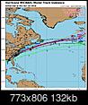
9Oct18 10pCDT/11pEDT - Winds 125mph(205km/h), moving N 12mph(19km/h), pressure 947mb. Still Cat3, nearly a Cat4. NHC has it making landfall as a Cat4 on Wednesday at 130mph.
No stalling for this storm...it's off to Europe towards end of the weekend and early next week:
Flash flooding will be a concern across much of the SE US next 3 days. Tropical systems can bring up to several inches per hour rainfall rates.
3-day possible scattered rain total maps:

Updated cone map:

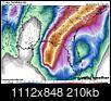
Tropical Storm force
winds (39+mph) just offshore slowly pushing towards the coast. 39mph is a good strong breeze but not destructive by itself. But wear and tear at around 39 and higher for a few hours will start bringing trees and power lines down some locations, likely starting late tonight. As more rain bands come in those winds will go up. Hurricane force winds(74+mph) are in the smaller red area near the center of storm. Many of the bridges near the coast will close once winds reach a certain speed, some at the TS wind threshold of 39mph. They may not reopen again until after the storm and inspections.
 Radar
Radar shows outer band just offshore but its coming in soon. Radar can only see so far out over water and we can't see the center clearly yet or the other half of the storm yet.

As these bands come ashore tonight and especially all day tomorrow through Thursday, we will see several small and brief lived
tornadoes that will tend to move in the direction of the rain band its associated with. These will pop up with little to no warning and quickly be gone again.
Storm surge will likely be a big story with this storm, can be very destructive if higher values are seen in any developed areas. Surge is like an even higher high tide. It's the entire body of water rising with waves on top. Water is very heavy and it does not take much along the immediate coast to knock down buildings. Further inland it can flood up rivers and bays miles inland. Consult this interactive map (
https://www.nhc.noaa.gov/refresh/gra...ation#contents ) (***Note the time in the text just to top left corner of that main image/window of map...if it says "From 05 PM... then it hasn't updated tonight yet,,,updates about 90min after the main 5 and 11 updates, so make sure it says 11pm for latest info tonight) to see current possible heights from this storm. Waters are already rising and will begin cutting off escape routes entirely soon.

Mexico Beach FL to Keaton Beach FL...9-13 ft
Okaloosa/Walton County Line FL to Mexico Beach FL...6-9 ft
Keaton Beach FL to Cedar Key FL...6-9 ft
Cedar Key FL to Chassahowitzka FL...4-6 ft
Chassahowitzka to Anna Maria Island FL including Tampa Bay...2-4 ft
Alabama/Florida border to Okaloosa/Walton County Line FL...2-4 ft
Winds: message from NHC: "Everyone in the hurricane warning area along the Florida Gulf Coast should prepare for life-threatening major hurricane winds associated with the core of Michael. Hurricane force winds will also extend well inland across portions of the Florida Panhandle, southern Georgia, and southeast Alabama as Michael moves inland."

 Please register to participate in our discussions with 2 million other members - it's free and quick! Some forums can only be seen by registered members. After you create your account, you'll be able to customize options and access all our 15,000 new posts/day with fewer ads.


