Welcome to City-Data.com Forum!
U.S. CitiesCity-Data Forum Index
Go Back   City-Data Forum > General Forums > Weather
 [Register]
Please register to participate in our discussions with 2 million other members - it's free and quick! Some forums can only be seen by registered members. After you create your account, you'll be able to customize options and access all our 15,000 new posts/day with fewer ads.
View detailed profile (Advanced) or search
site with Google Custom Search

Search Forums  (Advanced)
 
Old 03-19-2015, 07:25 PM
 
Location: South Jersey
14,497 posts, read 9,439,592 times
Reputation: 5251

Advertisements

Quote:
Originally Posted by Cambium View Post
Hello?

New Bernie video. Awesome stuff! Southern CT, Long Island, Philly gonna get thumping snow!


Listen and Learn.

https://www.youtube.com/watch?v=pMlCcE_IYhY&feature=youtu.be
Ooh, I certainly hope so! Nice video. Naturally, I like this guy's forecast.
Reply With Quote Quick reply to this message

 
Old 03-19-2015, 08:59 PM
 
Location: Near the Coast SWCT
83,539 posts, read 75,373,979 times
Reputation: 16634
Quote:
Originally Posted by snj90 View Post
Ooh, I certainly hope so! Nice video. Naturally, I like this guy's forecast.
Good luck. Should be fun.

And I didnt know it would drop even south more. Gees. New Snow should stick around a few days at least in CT

NATIONAL WEATHER SERVICE NEW YORK NY
853 PM EDT THU MAR 19 2015

A POLAR VORTEX OVER HUDSON BAY DROPS SE SAT INTO NORTHERN NEW
ENGLAND/SE CANADA ON SUN. THIS WILL SEND ANOTHER STRONG COLD
FRONT THROUGH THE AREA SAT NIGHT WITH ANOTHER SHOT OF UNSEASONABLY
COLD AIR.

TEMPS WILL REMAIN BELOW NORMAL THROUGH TUE...AND THEN REBOUND TO
NORMAL LEVELS WED INTO THU AS HIGH PRESSURE BUILDS OFFSHORE AND A
DEEP-LAYERED SLY FLOW DEVELOPS
Reply With Quote Quick reply to this message
 
Old 03-20-2015, 04:29 AM
 
Location: Near the Coast SWCT
83,539 posts, read 75,373,979 times
Reputation: 16634
Current 6:20am Radar & 850mb temps. Freezing line at 4500' still down around DC & Salisbury.

Snowing over PA/MD

This time of year you cant use just the 850mb temps.. You have to look at the surface and 925mb temps. See below


And the 925mb temps. Check back and see how this looks this afternoon http://www.spc.noaa.gov/sfctest/new/viewsector.php?sector=16&parm=925mb&underlay=1&sou rce=1

Reply With Quote Quick reply to this message
 
Old 03-20-2015, 04:46 AM
 
Location: Near the Coast SWCT
83,539 posts, read 75,373,979 times
Reputation: 16634
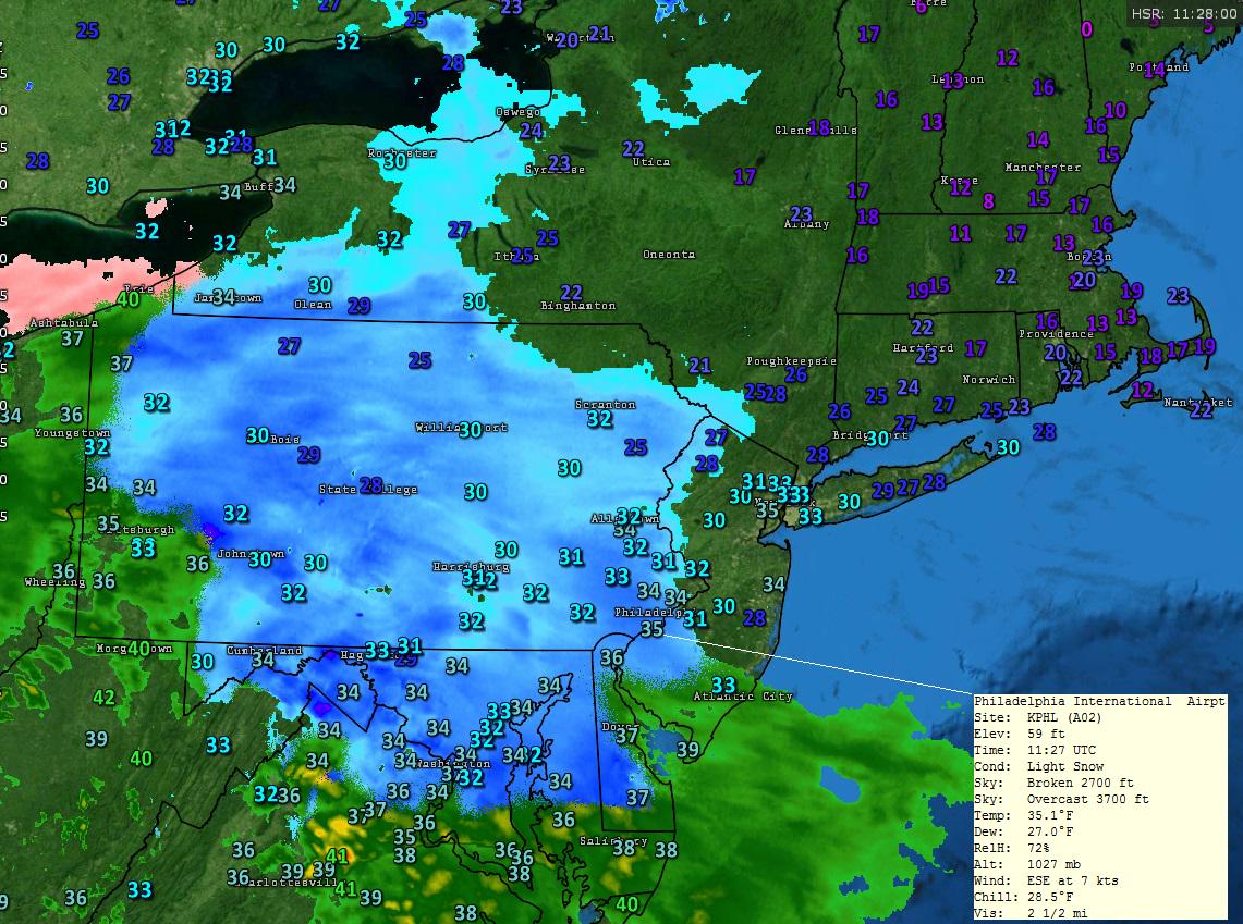
Latest Hi-Res NAM Radar Animation 2-9pm today. I still say the worst (I-84 South) will be from 3-6pm.

Notice that deeper blue band stretching from NJ to south of Hartford. Nobody knows where that band will setup and where it sets up will be where the extra intensity snows will be.

Otherwise steady light snow after 1pm in CT. But notice the thump snow in central NJ and parts of Long Island

This is a non even for north of I-84

Reply With Quote Quick reply to this message
 
Old 03-20-2015, 05:35 AM
 
Location: Near the Coast SWCT
83,539 posts, read 75,373,979 times
Reputation: 16634
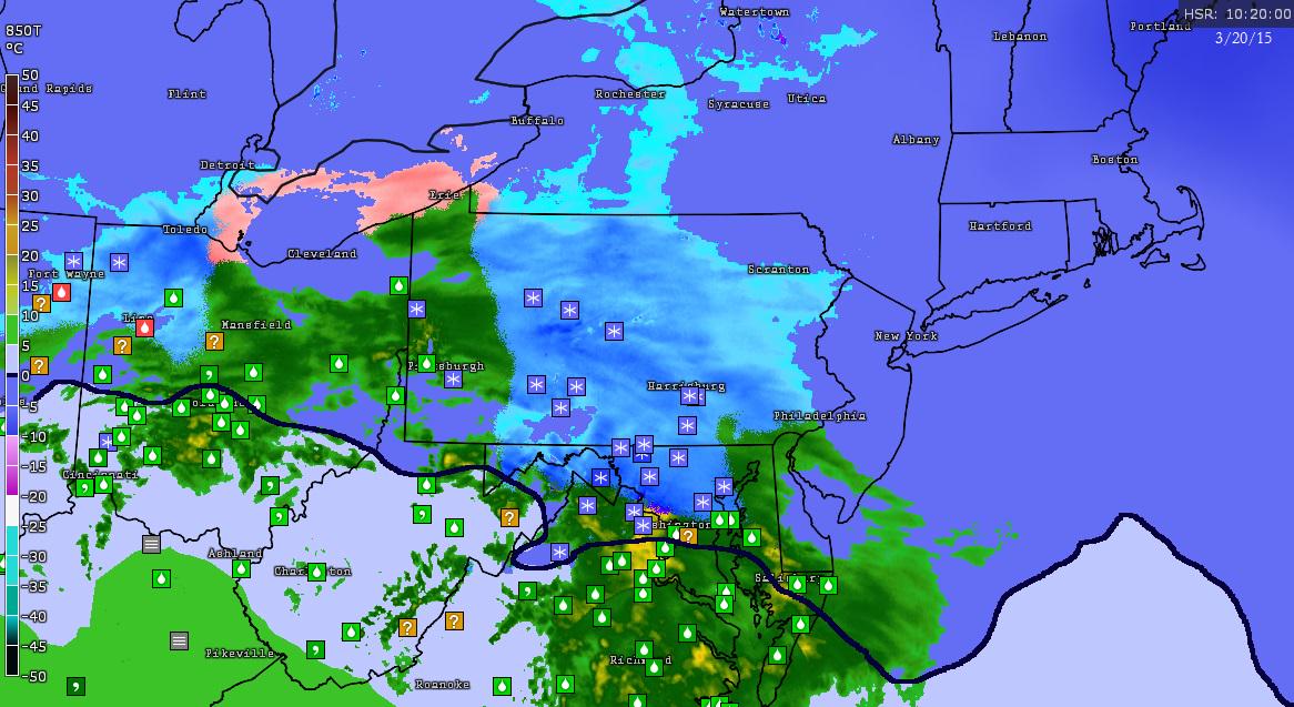
Temps in the teens in MA. 20s across CT. Philly reporting Flurries/Light Snow at 35°F. Seeing reports of heavier snows where the darker blues are in PA and MD

Reply With Quote Quick reply to this message
 
Old 03-20-2015, 05:53 AM
 
Location: South Jersey
14,497 posts, read 9,439,592 times
Reputation: 5251
Snowing here. Starting to stick to roofs, cars.
Reply With Quote Quick reply to this message
 
Old 03-20-2015, 05:59 AM
 
Location: Near the Coast SWCT
83,539 posts, read 75,373,979 times
Reputation: 16634
Quote:
Originally Posted by snj90 View Post
Snowing here. Starting to stick to roofs, cars.
Nice! Keep us posted.

https://twitter.com/ChrisRBarron/sta...006912/photo/1

"a couple of inches so far on the Great North Mountain on the VA/WV border"


Meanwhile.... in Nova Scotia. So when will this melt?

https://twitter.com/mikeseidel/statu...633088/photo/1

Reply With Quote Quick reply to this message
 
Old 03-20-2015, 06:58 AM
 
Location: South Jersey
14,497 posts, read 9,439,592 times
Reputation: 5251
Unfortunately not nearly heavy enough to lead to any significant accumulations. I hope it picks up, but this is not very encouraging.
Reply With Quote Quick reply to this message
 
Old 03-20-2015, 07:01 AM
 
Location: Northville, MI
11,879 posts, read 14,215,983 times
Reputation: 6381
Quote:
Originally Posted by snj90 View Post
Unfortunately not nearly heavy enough to lead to any significant accumulations. I hope it picks up, but this is not very encouraging.
It will all turn into rain and melt away.
Reply With Quote Quick reply to this message
 
Old 03-20-2015, 07:08 AM
 
Location: South Jersey
14,497 posts, read 9,439,592 times
Reputation: 5251
The grass is mostly white now. My cat looks like he's enjoying himself lying on the air vent by the back door, warming himself up & looking outside at the snow. lol
Reply With Quote Quick reply to this message
Please register to post and access all features of our very popular forum. It is free and quick. Over $68,000 in prizes has already been given out to active posters on our forum. Additional giveaways are planned.

Detailed information about all U.S. cities, counties, and zip codes on our site: City-data.com.


Reply
Please update this thread with any new information or opinions. This open thread is still read by thousands of people, so we encourage all additional points of view.

Quick Reply
Message:


Over $104,000 in prizes was already given out to active posters on our forum and additional giveaways are planned!

Go Back   City-Data Forum > General Forums > Weather

All times are GMT -6. The time now is 03:32 PM.

© 2005-2024, Advameg, Inc. · Please obey Forum Rules · Terms of Use and Privacy Policy · Bug Bounty

City-Data.com - Contact Us - Archive 1, 2, 3, 4, 5, 6, 7, 8, 9, 10, 11, 12, 13, 14, 15, 16, 17, 18, 19, 20, 21, 22, 23, 24, 25, 26, 27, 28, 29, 30, 31, 32, 33, 34, 35, 36, 37 - Top