Bridge Statistics for Detroit, Michigan (MI)
Condition, Traffic, Stress, Structural Evaluation, Project Costs
- National Bridge Inventory (NBI) Statistics
- 1,085Number of bridges
- 12,034ft / 3,668mTotal length
- $82,595,000Total costs
- 55,047,582Total average daily traffic
- 3,107,918Total average daily truck traffic
- National Bridge Inventory (NBI) Registered Bridges for Detroit
- No street view available for this location
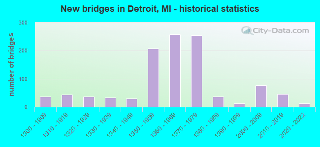
- New bridges - historical statistics
- 1Before 1900
- 371900-1909
- 431910-1919
- 371920-1929
- 331930-1939
- 291940-1949
- 2071950-1959
- 2591960-1969
- 2551970-1979
- 361980-1989
- 131990-1999
- 762000-2009
- 462010-2019
- 132020-2022
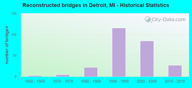
- Reconstructed bridges - Historical Statistics
- 31960-1969
- 51970-1979
- 221980-1989
- 1161990-1999
- 852000-2009
- 272010-2019
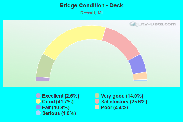
- Bridge Condition - Deck
- 2.5%Excellent
- 14.0%Very good
- 41.7%Good
- 25.6%Satisfactory
- 10.8%Fair
- 4.4%Poor
- 1.0%Serious
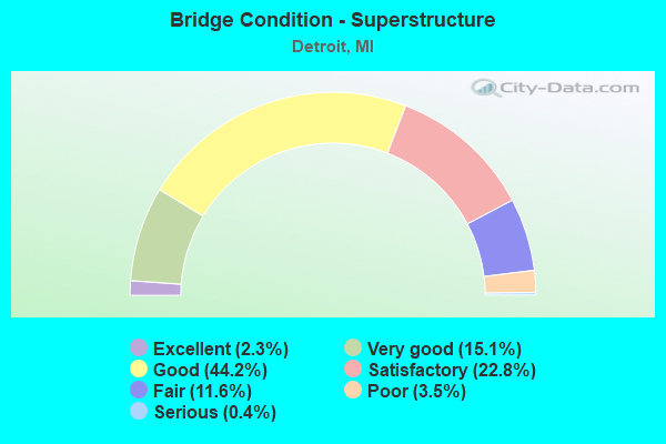
- Bridge Condition - Superstructure
- 2.3%Excellent
- 15.1%Very good
- 44.2%Good
- 22.8%Satisfactory
- 11.6%Fair
- 3.5%Poor
- 0.4%Serious
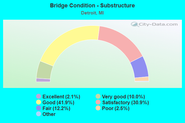
- Bridge Condition - Substructure
- 2.1%Excellent
- 10.0%Very good
- 41.9%Good
- 30.9%Satisfactory
- 12.2%Fair
- 2.5%Poor
- 0.4%Serious
- 0.2%Failed
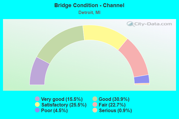
- Bridge Condition - Channel
- 15.5%Very good
- 30.9%Good
- 25.5%Satisfactory
- 22.7%Fair
- 4.5%Poor
- 0.9%Serious
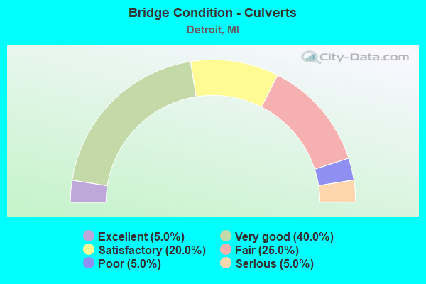
- Bridge Condition - Culverts
- 5.0%Excellent
- 40.0%Very good
- 20.0%Satisfactory
- 25.0%Fair
- 5.0%Poor
- 5.0%Serious
Find on map >> Show street view
Structure Number: 11766, Location: IN DETROIT (Lat: 42.333739, Lng: -83.063061), Route carried "under" structure: State highway 10, Year Built: 1970, Structure Length: 0. m, Average Daily Traffic: 104,516 (year 2007), Truck Traffic: 1%, Features Intersected: M-10, Facility Carried by Structure: I-75 E-N RAMP
Minimum Vertical Clearance: 4.90m (16.08ft), Kilometerpoint: 18.368, Lanes on structure: 1, Lanes under structure: 9, Material/Design: Steel continuous, Design/Construction: Stringer/Multi-beam, Length of Maximum Span: 25.8m (84.6ft)
Find on map >> Show street view
Structure Number: 11767, Location: IN DETROIT (Lat: 42.334853, Lng: -83.063358), Route carried "under" structure: State highway 10, Year Built: 1970, Structure Length: 0. m, Average Daily Traffic: 104,516 (year 2007), Truck Traffic: 1%, Features Intersected: M-10
Minimum Vertical Clearance: 6.02m (19.75ft), Kilometerpoint: 18.263, Lanes on structure: 1, Lanes under structure: 10, Material/Design: Steel, Design/Construction: Stringer/Multi-beam, Length of Maximum Span: 23.1m (75.8ft)
Find on map >> Show street view
Structure Number: 11768, Location: IN DETROIT OVER US-10 (Lat: 42.335311, Lng: -83.064000), Route carried "under" structure: State highway 10, Year Built: 1970, Structure Length: 0. m, Average Daily Traffic: 111,518 (year 2007), Truck Traffic: 1%, Features Intersected: M-10, Facility Carried by Structure: I-75 NB
Minimum Vertical Clearance: 5.18m (16.99ft), Kilometerpoint: 18.172, Lanes on structure: 3, Lanes under structure: 8, Material/Design: Steel, Design/Construction: Stringer/Multi-beam, Length of Maximum Span: 37.8m (124.0ft)
Find on map >> Show street view
Structure Number: 11769, Location: IN DETROIT (Lat: 42.335464, Lng: -83.064125), Route carried "under" structure: State highway 10, Year Built: 1953, Structure Length: 0. m, Average Daily Traffic: 111,518 (year 2007), Truck Traffic: 2%, Features Intersected: M-10, Facility Carried by Structure: I-75 SB
Minimum Vertical Clearance: 5.03m (16.50ft), Kilometerpoint: 18.154, Lanes on structure: 6, Lanes under structure: 8, Material/Design: Steel, Design/Construction: Stringer/Multi-beam, Length of Maximum Span: 35.9m (117.8ft)
Find on map >> Show street view
Structure Number: 1177, Location: IN DETROIT (Lat: 42.335906, Lng: -83.064414), Route carried "under" structure: State highway 10, Year Built: 1970, Structure Length: 0. m, Average Daily Traffic: 111,518 (year 2007), Truck Traffic: 2%, Features Intersected: M-10
Minimum Vertical Clearance: 7.09m (23.26ft), Kilometerpoint: 18.111, Lanes on structure: 1, Lanes under structure: 7, Material/Design: Steel continuous, Design/Construction: Stringer/Multi-beam, Length of Maximum Span: 25.9m (85.0ft)
Find on map >> Show street view
Structure Number: 11771, Location: IN DETROIT (Lat: 42.336639, Lng: -83.064994), Route carried "under" structure: State highway 10, Year Built: 1970, Structure Length: 0. m, Average Daily Traffic: 111,518 (year 2007), Truck Traffic: 2%, Features Intersected: M-10, Facility Carried by Structure: I-75 W S RAMP
Minimum Vertical Clearance: 5.69m (18.67ft), Kilometerpoint: 18.014, Lanes on structure: 1, Lanes under structure: 6, Material/Design: Steel, Design/Construction: Stringer/Multi-beam, Length of Maximum Span: 21.6m (70.9ft)
Find on map >> Show street view
Structure Number: 11772, Location: IN DETROIT (Lat: 42.335172, Lng: -83.062378), Route carried "under" structure: Interstate 75, Year Built: 1970, Structure Length: 0. m, Average Daily Traffic: 92,802 (year 2007), Truck Traffic: 14%, Features Intersected: I-75 & EXIT RAMPS, Facility Carried by Structure: M-10 N-W RAMP
Minimum Vertical Clearance: 5.64m (18.50ft), Kilometerpoint: 37.382, Lanes on structure: 1, Lanes under structure: 9, Material/Design: Steel, Design/Construction: Stringer/Multi-beam, Length of Maximum Span: 21.3m (69.9ft)
Find on map >> Show street view
Structure Number: 11773, Location: IN DETROIT (Lat: 42.335639, Lng: -83.061325), Route carried "under" structure: Ramp State highway 75, Year Built: 1970, Structure Length: 0. m, Average Daily Traffic: 22,000 (year 1988), Features Intersected: M-10 TO I-75N RAMP
Minimum Vertical Clearance: 4.47m (14.67ft), Kilometerpoint: 0.377, Lanes on structure: 1, Lanes under structure: 2, Material/Design: Steel, Design/Construction: Stringer/Multi-beam, Length of Maximum Span: 28.0m (91.9ft)
Find on map >> Show street view
Structure Number: 11774, Location: IN DETROIT OVER LODGE (Lat: 42.336256, Lng: -83.061650), Route carried "under" structure: Ramp Interstate 75, Year Built: 1970, Structure Length: 0. m, Average Daily Traffic: 9,500 (year 0000), Features Intersected: I-75 NB ENT RAMP
Minimum Vertical Clearance: 4.52m (14.83ft), Kilometerpoint: 0.105, Lanes on structure: 1, Lanes under structure: 1, Material/Design: Steel, Design/Construction: Stringer/Multi-beam, Length of Maximum Span: 27.7m (90.9ft)
Find on map >> Show street view
Structure Number: 11775, Location: IN DETROIT (Lat: 42.336197, Lng: -83.060075), Route carried "under" structure: Interstate 75, Year Built: 1967, Structure Length: 0. m, Average Daily Traffic: 92,802 (year 2007), Truck Traffic: 14%, Features Intersected: I-75, Facility Carried by Structure: THIRD AVE
Minimum Vertical Clearance: 5.18m (16.99ft), Kilometerpoint: 37.588, Lanes on structure: 4, Lanes under structure: 8, Material/Design: Steel continuous, Design/Construction: Stringer/Multi-beam, Length of Maximum Span: 26.5m (86.9ft)
Find on map >> Show street view
Structure Number: 11776, Location: IN DETROIT (Lat: 42.336489, Lng: -83.059125), Route carried "under" structure: Interstate 75, Year Built: 1967, Structure Length: 0. m, Average Daily Traffic: 92,802 (year 2007), Truck Traffic: 14%, Features Intersected: I-75, Facility Carried by Structure: M-5 GRAND RIV AVE
Minimum Vertical Clearance: 5.13m (16.83ft), Kilometerpoint: 37.671, Lanes on structure: 6, Lanes under structure: 8, Material/Design: Steel continuous, Design/Construction: Stringer/Multi-beam, Length of Maximum Span: 27.5m (90.2ft)
Find on map >> Show street view
Structure Number: 11777, Location: IN DETROIT (Lat: 42.336903, Lng: -83.058286), Route carried "under" structure: Interstate 75, Year Built: 1967, Structure Length: 0. m, Average Daily Traffic: 75,000 (year 2007), Truck Traffic: 14%, Features Intersected: I-75, Facility Carried by Structure: SECOND BLVD
Minimum Vertical Clearance: 5.23m (17.16ft), Kilometerpoint: 37.755, Lanes on structure: 4, Lanes under structure: 8, Material/Design: Prestressed concrete, Design/Construction: Box Beam or Girders - Multiple, Length of Maximum Span: 23.8m (78.1ft)
Find on map >> Show street view
Structure Number: 11778, Location: IN DETROIT (Lat: 42.338072, Lng: -83.056450), Route carried "under" structure: Interstate 75, Year Built: 1967, Structure Length: 0. m, Average Daily Traffic: 92,802 (year 2007), Truck Traffic: 14%, Features Intersected: I-75, Facility Carried by Structure: CASS AVE
Minimum Vertical Clearance: 4.65m (15.26ft), Kilometerpoint: 37.954, Lanes on structure: 4, Lanes under structure: 8, Material/Design: Steel, Design/Construction: Stringer/Multi-beam, Length of Maximum Span: 28.2m (92.5ft)
Find on map >> Show street view
Structure Number: 11779, Location: IN DETROIT (Lat: 42.338411, Lng: -83.055919), Route carried "under" structure: Interstate 75, Year Built: 1967, Structure Length: 0. m, Average Daily Traffic: 92,802 (year 2007), Truck Traffic: 14%, Features Intersected: I-75, Facility Carried by Structure: CLIFFORD ST
Minimum Vertical Clearance: 4.95m (16.24ft), Kilometerpoint: 38.012, Lanes on structure: 3, Lanes under structure: 8, Material/Design: Steel continuous, Design/Construction: Stringer/Multi-beam, Length of Maximum Span: 23.7m (77.8ft)
Find on map >> Show street view
Structure Number: 1178, Location: IN DETROIT (Lat: 42.339842, Lng: -83.052808), Route carried "under" structure: Interstate 75, Year Built: 2014, Structure Length: 0. m, Average Daily Traffic: 92,802 (year 2007), Truck Traffic: 14%, Features Intersected: I-75, Facility Carried by Structure: M-1 WOODWARD AV
Minimum Vertical Clearance: 4.85m (15.91ft), Kilometerpoint: 38.313, Lanes on structure: 5, Lanes under structure: 9, Material/Design: Steel continuous, Design/Construction: Stringer/Multi-beam, Length of Maximum Span: 25.6m (84.0ft)
Find on map >> Show street view
Structure Number: 11781, Location: IN DETROIT (Lat: 42.340889, Lng: -83.050319), Route carried "under" structure: Interstate 75, Year Built: 1970, Structure Length: 0. m, Average Daily Traffic: 92,802 (year 2007), Truck Traffic: 14%, Features Intersected: I-75, Facility Carried by Structure: JOHN R
Minimum Vertical Clearance: 4.52m (14.83ft), Kilometerpoint: 38.550, Lanes on structure: 4, Lanes under structure: 8, Material/Design: Steel, Design/Construction: Stringer/Multi-beam, Length of Maximum Span: 25.9m (85.0ft)
Find on map >> Show street view
Structure Number: 11782, Location: IN DETROIT (Lat: 42.341578, Lng: -83.048508), Route carried "under" structure: Interstate 75, Year Built: 1970, Structure Length: 0. m, Average Daily Traffic: 22,748 (year 2007), Features Intersected: I-75, Facility Carried by Structure: BRUSH ST
Minimum Vertical Clearance: 4.60m (15.09ft), Kilometerpoint: 38.717, Lanes on structure: 3, Lanes under structure: 8, Material/Design: Steel, Design/Construction: Stringer/Multi-beam, Length of Maximum Span: 27.4m (89.9ft)
Find on map >> Show street view
Structure Number: 11783, Location: IN DETROIT (Lat: 42.344883, Lng: -83.039514), Route carried "under" structure: Alternate State highway 3, Year Built: 1970, Structure Length: 0. m, Average Daily Traffic: 22,748 (year 2007), Features Intersected: I-75 CONN TO M-3, Facility Carried by Structure: RUSSELL ST
Minimum Vertical Clearance: 4.82m (15.81ft), Kilometerpoint: 39.545, Lanes on structure: 5, Lanes under structure: 6, Material/Design: Steel continuous, Design/Construction: Stringer/Multi-beam, Length of Maximum Span: 24.3m (79.7ft)
Find on map >> Show street view
Structure Number: 11797, Location: IN DETROIT (Lat: 42.346114, Lng: -83.044428), Route carried "under" structure: Interstate 75, Year Built: 1961, Structure Length: 0. m, Average Daily Traffic: 116,840 (year 2007), Truck Traffic: 12%, Features Intersected: I-75, Facility Carried by Structure: DIVISION AVE WALKO
Minimum Vertical Clearance: 5.44m (17.85ft), Kilometerpoint: 2.295, Lanes under structure: 10, Material/Design: Steel, Design/Construction: Girder and Floorbeam System, Length of Maximum Span: 27.1m (88.9ft)
Find on map >> Show street view
Structure Number: 11798, Location: IN DETROIT (Lat: 42.353778, Lng: -83.049558), Route carried "under" structure: Interstate 75, Year Built: 1961, Structure Length: 0. m, Average Daily Traffic: 145,494 (year 2007), Truck Traffic: 10%, Features Intersected: I-75, Facility Carried by Structure: LELAND ST WALKOVER
Minimum Vertical Clearance: 5.11m (16.77ft), Kilometerpoint: 3.245, Lanes under structure: 10, Material/Design: Steel, Design/Construction: Girder and Floorbeam System, Length of Maximum Span: 26.5m (86.9ft)
Find on map >> Show street view
Structure Number: 11799, Location: DOWNTOWN DETROIT (Lat: 42.340161, Lng: -83.041339), Route carried "under" structure: Interstate 375, Year Built: 1963, Structure Length: 0. m, Average Daily Traffic: 74,048 (year 2007), Truck Traffic: 1%, Features Intersected: I-375, Facility Carried by Structure: M-3 (GRATIOT AVE)
Minimum Vertical Clearance: 4.95m (16.24ft), Kilometerpoint: 1.569, Lanes on structure: 8, Lanes under structure: 8, Material/Design: Steel, Design/Construction: Stringer/Multi-beam, Length of Maximum Span: 23.7m (77.8ft)
Find on map >> Show street view
Structure Number: 118, Location: IN DETROIT (Lat: 42.340047, Lng: -83.041978), Route carried "under" structure: Interstate 375, Year Built: 1964, Structure Length: 0. m, Average Daily Traffic: 74,048 (year 2007), Truck Traffic: 1%, Features Intersected: I-375, Facility Carried by Structure: MADISON AVE RAMPS
Minimum Vertical Clearance: 4.44m (14.57ft), Kilometerpoint: 1.569, Lanes on structure: 4, Lanes under structure: 3, Material/Design: Steel, Design/Construction: Stringer/Multi-beam, Length of Maximum Span: 32.6m (107.0ft)
Find on map >> Show street view
Structure Number: 11801, Location: IN DETROIT OVER I-375 (Lat: 42.342342, Lng: -83.043383), Route carried "under" structure: Interstate 375, Year Built: 1964, Structure Length: 0. m, Average Daily Traffic: 74,048 (year 2007), Truck Traffic: 1%, Features Intersected: I-375
Minimum Vertical Clearance: 5.28m (17.32ft), Kilometerpoint: 1.867, Lanes on structure: 2, Lanes under structure: 9, Material/Design: Steel, Design/Construction: Stringer/Multi-beam, Length of Maximum Span: 36.2m (118.8ft)
Find on map >> Show street view
Structure Number: 11802, Location: IN DETROIT OVER I-375 (Lat: 42.343064, Lng: -83.043403), Route carried "under" structure: Interstate 375, Year Built: 1964, Structure Length: 0. m, Average Daily Traffic: 87,592 (year 2007), Truck Traffic: 15%, Features Intersected: I-375, Facility Carried by Structure: I-75 S E TURN RD
Minimum Vertical Clearance: 6.10m (20.01ft), Kilometerpoint: 0.361, Lanes on structure: 1, Lanes under structure: 10, Material/Design: Steel, Design/Construction: Stringer/Multi-beam, Length of Maximum Span: 33.5m (109.9ft)
Find on map >> Show street view
Structure Number: 11803, Location: IN DETROIT OVER E N TURN (Lat: 42.341994, Lng: -83.046819), Route carried "under" structure: Ramp Interstate 75, Year Built: 1970, Structure Length: 0. m, Average Daily Traffic: 87,592 (year 2007), Truck Traffic: 15%, Features Intersected: I-75 EB I-375 SB TRN RDY, Facility Carried by Structure: BRUSH ST ENT RAMP
Minimum Vertical Clearance: 5.05m (16.57ft), Kilometerpoint: 0.204, Lanes on structure: 1, Lanes under structure: 2, Material/Design: Steel, Design/Construction: Stringer/Multi-beam, Length of Maximum Span: 24.7m (81.0ft)
Find on map >> Show street view
Structure Number: 11805, Location: I-75 & I-375 INTCHG (Lat: 42.342508, Lng: -83.046150), Route carried "under" structure: Ramp Interstate 75, Year Built: 1970, Structure Length: 0. m, Average Daily Traffic: 42,500 (year 1995), Truck Traffic: 15%, Features Intersected: I-75 SB TO EB RAMP
Minimum Vertical Clearance: 4.44m (14.57ft), Kilometerpoint: 0.264, Lanes on structure: 3, Lanes under structure: 1, Material/Design: Steel, Design/Construction: Stringer/Multi-beam, Length of Maximum Span: 10.3m (33.8ft)
Find on map >> Show street view
Structure Number: 11806, Location: I-75 & I-375 INTCHG (Lat: 42.342686, Lng: -83.046236), Route carried "under" structure: Ramp Interstate 75, Year Built: 1970, Structure Length: 0. m, Average Daily Traffic: 2,700 (year 0000), Features Intersected: I-75 SB TO EB RAMP
Minimum Vertical Clearance: 5.08m (16.67ft), Kilometerpoint: 0.243, Lanes on structure: 3, Lanes under structure: 1, Material/Design: Steel, Design/Construction: Stringer/Multi-beam, Length of Maximum Span: 10.3m (33.8ft)
Find on map >> Show street view
Structure Number: 11808, Location: IN DETROIT OVER I-375 (Lat: 42.343447, Lng: -83.043536), Route carried "under" structure: Interstate 375, Year Built: 1964, Structure Length: 0. m, Average Daily Traffic: 87,592 (year 2007), Truck Traffic: 15%, Features Intersected: I-75 & I-375, Facility Carried by Structure: M-3 NB CONN
Minimum Vertical Clearance: 6.12m (20.08ft), Kilometerpoint: 0.404, Lanes on structure: 2, Lanes under structure: 10, Material/Design: Steel, Design/Construction: Stringer/Multi-beam, Length of Maximum Span: 24.1m (79.1ft)
Find on map >> Show street view
Structure Number: 11809, Location: IN DETROIT OVER I-375 (Lat: 42.343658, Lng: -83.043611), Route carried "under" structure: Interstate 375, Year Built: 1964, Structure Length: 0. m, Average Daily Traffic: 87,592 (year 2007), Truck Traffic: 15%, Features Intersected: I-75 & I-375, Facility Carried by Structure: M-3 SB CONN
Minimum Vertical Clearance: 6.12m (20.08ft), Kilometerpoint: 0.428, Lanes on structure: 2, Lanes under structure: 10, Material/Design: Steel, Design/Construction: Stringer/Multi-beam, Length of Maximum Span: 24.1m (79.1ft)
Find on map >> Show street view
Structure Number: 1181, Location: IN DETROIT OVER I-375 NW (Lat: 42.343911, Lng: -83.042231), Route carried "under" structure: Ramp Interstate 375, Year Built: 1964, Structure Length: 0. m, Average Daily Traffic: 11,800 (year 0000), Features Intersected: I-375 & I-75 RAMP, Facility Carried by Structure: M-3 EB CONN
Minimum Vertical Clearance: 5.28m (17.32ft), Kilometerpoint: 0.084, Lanes on structure: 3, Lanes under structure: 1, Material/Design: Steel, Design/Construction: Stringer/Multi-beam, Length of Maximum Span: 11.8m (38.7ft)
Find on map >> Show street view
Structure Number: 11811, Location: IN DETROIT OVER I-375 NW (Lat: 42.344139, Lng: -83.042219), Route carried "under" structure: Ramp Interstate 375, Year Built: 1964, Structure Length: 0. m, Average Daily Traffic: 11,800 (year 0000), Features Intersected: I-375 & I-75 RAMP, Facility Carried by Structure: M-3 WB CONN
Minimum Vertical Clearance: 4.62m (15.16ft), Kilometerpoint: 0.109, Lanes on structure: 2, Lanes under structure: 1, Material/Design: Steel, Design/Construction: Stringer/Multi-beam, Length of Maximum Span: 11.8m (38.7ft)
Find on map >> Show street view
Structure Number: 11812, Location: IN DETROIT (Lat: 42.344683, Lng: -83.043983), Route carried "under" structure: Interstate 75, Year Built: 1963, Structure Length: 0. m, Average Daily Traffic: 116,840 (year 2007), Truck Traffic: 12%, Features Intersected: I-75 & RAMP
Minimum Vertical Clearance: 6.10m (20.01ft), Kilometerpoint: 2.132, Lanes on structure: 1, Lanes under structure: 9, Material/Design: Steel, Design/Construction: Stringer/Multi-beam, Length of Maximum Span: 36.2m (118.8ft)
Find on map >> Show street view
Structure Number: 11813, Location: IN DETROIT (Lat: 42.344944, Lng: -83.044028), Route carried "under" structure: Interstate 75, Year Built: 1963, Structure Length: 0. m, Average Daily Traffic: 116,840 (year 2007), Truck Traffic: 12%, Features Intersected: I-75
Minimum Vertical Clearance: 4.92m (16.14ft), Kilometerpoint: 2.161, Lanes on structure: 2, Lanes under structure: 8, Material/Design: Steel, Design/Construction: Stringer/Multi-beam, Length of Maximum Span: 26.8m (87.9ft)
Find on map >> Show street view
Structure Number: 11814, Location: IN DETROIT (Lat: 42.347992, Lng: -83.045653), Route carried "under" structure: Interstate 75, Year Built: 1961, Structure Length: 0. m, Average Daily Traffic: 116,840 (year 2007), Truck Traffic: 12%, Features Intersected: I-75, Facility Carried by Structure: WILKINS ST & RAMP
Minimum Vertical Clearance: 4.57m (14.99ft), Kilometerpoint: 2.527, Lanes on structure: 2, Lanes under structure: 10, Material/Design: Steel, Design/Construction: Stringer/Multi-beam, Length of Maximum Span: 26.5m (86.9ft)
Find on map >> Show street view
Structure Number: 11815, Location: IN DETROIT (Lat: 42.351219, Lng: -83.047817), Route carried "under" structure: Interstate 75, Year Built: 1961, Structure Length: 0. m, Average Daily Traffic: 145,494 (year 2007), Truck Traffic: 10%, Features Intersected: I-75, Facility Carried by Structure: MACK AVE
Minimum Vertical Clearance: 4.55m (14.93ft), Kilometerpoint: 2.942, Lanes on structure: 10, Lanes under structure: 8, Material/Design: Steel, Design/Construction: Stringer/Multi-beam, Length of Maximum Span: 22.7m (74.5ft)
Find on map >> Show street view
Structure Number: 11816, Location: IN DETROIT (Lat: 42.356633, Lng: -83.051436), Route carried "under" structure: Interstate 75, Year Built: 1962, Structure Length: 0. m, Average Daily Traffic: 145,494 (year 2007), Truck Traffic: 10%, Features Intersected: I-75, Facility Carried by Structure: CANFIELD AVE
Minimum Vertical Clearance: 4.62m (15.16ft), Kilometerpoint: 3.599, Lanes on structure: 2, Lanes under structure: 10, Material/Design: Steel, Design/Construction: Stringer/Multi-beam, Length of Maximum Span: 26.5m (86.9ft)
Find on map >> Show street view
Structure Number: 11817, Location: IN DETROIT (Lat: 42.360836, Lng: -83.054236), Route carried "under" structure: Interstate 75, Year Built: 1962, Structure Length: 0. m, Average Daily Traffic: 145,494 (year 2007), Truck Traffic: 10%, Features Intersected: I-75, Facility Carried by Structure: WARREN AVE
Minimum Vertical Clearance: 4.72m (15.49ft), Kilometerpoint: 4.118, Lanes on structure: 12, Lanes under structure: 8, Material/Design: Steel, Design/Construction: Stringer/Multi-beam, Length of Maximum Span: 22.8m (74.8ft)
Find on map >> Show street view
Structure Number: 11818, Location: IN DETROIT (Lat: 42.362581, Lng: -83.054728), Route carried "under" structure: Ramp Interstate 75, Year Built: 1964, Structure Length: 0. m, Average Daily Traffic: 22,400 (year 1978), Features Intersected: I-75 NB TO E&W TURN RDWY
Minimum Vertical Clearance: 4.57m (14.99ft), Kilometerpoint: 0.177, Lanes on structure: 1, Lanes under structure: 2, Material/Design: Steel, Design/Construction: Stringer/Multi-beam, Length of Maximum Span: 29.3m (96.1ft)
Find on map >> Show street view
Structure Number: 11819, Location: IN DETROIT (Lat: 42.363403, Lng: -83.056267), Route carried "under" structure: Ramp Interstate 94, Year Built: 1964, Structure Length: 0. m, Average Daily Traffic: 22,400 (year 0000), Features Intersected: I-75 E&W TO SB TURN RDWY, Facility Carried by Structure: I-75 SB EXIT RAMP
Minimum Vertical Clearance: 4.57m (14.99ft), Kilometerpoint: 0.661, Lanes on structure: 1, Lanes under structure: 2, Material/Design: Steel, Design/Construction: Stringer/Multi-beam, Length of Maximum Span: 33.8m (110.9ft)
Find on map >> Show street view
Structure Number: 1182, Location: IN DETROIT (Lat: 42.364856, Lng: -83.057333), Route carried "under" structure: Ramp Interstate 94, Year Built: 1962, Structure Length: 0. m, Average Daily Traffic: 22,400 (year 1978), Features Intersected: I-94 E&W RMPS TO I-75 S, Facility Carried by Structure: FERRY AVE
Minimum Vertical Clearance: 4.67m (15.32ft), Kilometerpoint: 0.478, Lanes on structure: 4, Lanes under structure: 2, Material/Design: Steel, Design/Construction: Stringer/Multi-beam, Length of Maximum Span: 14.3m (46.9ft)
Find on map >> Show street view
Structure Number: 11821, Location: IN DETROIT (Lat: 42.365275, Lng: -83.056189), Route carried "under" structure: Interstate 75, Year Built: 1962, Structure Length: 0. m, Average Daily Traffic: 134,288 (year 2007), Truck Traffic: 11%, Features Intersected: I-75 & TURN RDWY, Facility Carried by Structure: FERRY AVE
Minimum Vertical Clearance: 4.80m (15.75ft), Kilometerpoint: 4.637, Lanes on structure: 4, Lanes under structure: 8, Material/Design: Steel, Design/Construction: Stringer/Multi-beam, Length of Maximum Span: 19.2m (63.0ft)
Find on map >> Show street view
Structure Number: 11822, Location: IN DETROIT (Lat: 42.366519, Lng: -83.061408), Route carried "under" structure: Ramp Interstate 94, Year Built: 1961, Structure Length: 0. m, Average Daily Traffic: 18,000 (year 0000), Features Intersected: I-75 RAMP TO I-94
Minimum Vertical Clearance: 4.67m (15.32ft), Kilometerpoint: 0.080, Lanes on structure: 1, Lanes under structure: 2, Material/Design: Steel, Design/Construction: Stringer/Multi-beam, Length of Maximum Span: 24.0m (78.7ft)
Find on map >> Show street view
Structure Number: 11823, Location: IN DETROIT (Lat: 42.366436, Lng: -83.059597), Route carried "under" structure: Ramp Interstate 94, Year Built: 1964, Structure Length: 0. m, Average Daily Traffic: 12,100 (year 1995), Features Intersected: I-94EB TO I-75NB RAMP
Minimum Vertical Clearance: 4.98m (16.34ft), Kilometerpoint: 0.134, Lanes on structure: 2, Lanes under structure: 1, Material/Design: Steel, Design/Construction: Stringer/Multi-beam, Length of Maximum Span: 17.1m (56.1ft)
Find on map >> Show street view
Structure Number: 11824, Location: IN DETROIT (Lat: 42.367275, Lng: -83.057333), Route carried "under" structure: Interstate 75, Year Built: 1964, Structure Length: 0. m, Average Daily Traffic: 133,000 (year 2013), Truck Traffic: 9%, Features Intersected: I-75
Minimum Vertical Clearance: 5.59m (18.34ft), Kilometerpoint: 4.878, Lanes on structure: 1, Lanes under structure: 6, Material/Design: Steel, Design/Construction: Stringer/Multi-beam, Length of Maximum Span: 36.2m (118.8ft)
Find on map >> Show street view
Structure Number: 11825, Location: IN DETROIT (Lat: 42.367844, Lng: -83.059792), Route carried "under" structure: Interstate 94, Year Built: 1962, Structure Length: 0. m, Average Daily Traffic: 127,708 (year 2007), Truck Traffic: 13%, Features Intersected: I-94
Minimum Vertical Clearance: 5.66m (18.57ft), Kilometerpoint: 45.871, Lanes on structure: 2, Lanes under structure: 8, Material/Design: Steel, Design/Construction: Stringer/Multi-beam, Length of Maximum Span: 27.1m (88.9ft)
Find on map >> Show street view
Structure Number: 11826, Location: IN DETROIT (Lat: 42.367786, Lng: -83.057356), Route carried "under" structure: Interstate 75, Year Built: 1964, Structure Length: 0. m, Average Daily Traffic: 127,708 (year 2007), Truck Traffic: 13%, Features Intersected: I-75 & RAMP
Minimum Vertical Clearance: 9.14m (29.99ft), Kilometerpoint: 46.045, Lanes on structure: 1, Lanes under structure: 7, Material/Design: Steel, Design/Construction: Stringer/Multi-beam, Length of Maximum Span: 32.9m (107.9ft)
Find on map >> Show street view
Structure Number: 11827, Location: IN DETROIT (Lat: 42.368986, Lng: -83.056742), Route carried "under" structure: Ramp Interstate 94, Year Built: 1964, Structure Length: 0. m, Average Daily Traffic: 5,000 (year 1978), Features Intersected: RUSSELL ST CONN
Minimum Vertical Clearance: 6.43m (21.10ft), Kilometerpoint: 0.111, Lanes on structure: 1, Lanes under structure: 1, Material/Design: Steel, Design/Construction: Stringer/Multi-beam, Length of Maximum Span: 32.0m (105.0ft)
Find on map >> Show street view
Structure Number: 11828, Location: IN DETROIT (Lat: 42.368572, Lng: -83.057717), Route carried "under" structure: Interstate 75, Year Built: 1962, Structure Length: 0. m, Average Daily Traffic: 151,136 (year 2007), Truck Traffic: 7%, Features Intersected: I-75, Facility Carried by Structure: I-94
Minimum Vertical Clearance: 5.39m (17.68ft), Kilometerpoint: 5.050, Lanes on structure: 7, Lanes under structure: 7, Material/Design: Steel, Design/Construction: Stringer/Multi-beam, Length of Maximum Span: 21.0m (68.9ft)
Find on map >> Show street view
Structure Number: 11829, Location: IN DETROIT (Lat: 42.367772, Lng: -83.060506), Route carried "under" structure: Ramp Interstate 94, Year Built: 1964, Structure Length: 0. m, Average Daily Traffic: 5,000 (year 1978), Features Intersected: NORTH SERVICE RD, Facility Carried by Structure: I-75 S-W RAMP
Minimum Vertical Clearance: 4.57m (14.99ft), Kilometerpoint: 0.166, Lanes on structure: 2, Lanes under structure: 1, Material/Design: Steel, Design/Construction: Stringer/Multi-beam, Length of Maximum Span: 20.1m (65.9ft)
Find on map >> Show street view
Structure Number: 1183, Location: IN DETROIT (Lat: 42.369000, Lng: -83.057931), Route carried "under" structure: Interstate 75, Year Built: 1962, Structure Length: 0. m, Average Daily Traffic: 151,136 (year 2007), Truck Traffic: 7%, Features Intersected: I-75 & RAMP, Facility Carried by Structure: I-94 W-S RAMP
Minimum Vertical Clearance: 4.57m (14.99ft), Kilometerpoint: 5.071, Lanes on structure: 2, Lanes under structure: 7, Material/Design: Steel, Design/Construction: Stringer/Multi-beam, Length of Maximum Span: 20.2m (66.3ft)
Find on map >> Show street view
Structure Number: 11831, Location: IN DETROIT (Lat: 42.368883, Lng: -83.057356), Route carried "under" structure: Interstate 94, Year Built: 1962, Structure Length: 0. m, Average Daily Traffic: 180,032 (year 2007), Truck Traffic: 4%, Features Intersected: I-94
Minimum Vertical Clearance: 4.65m (15.26ft), Kilometerpoint: 46.154, Lanes on structure: 1, Lanes under structure: 8, Material/Design: Steel, Design/Construction: Stringer/Multi-beam, Length of Maximum Span: 30.4m (99.7ft)
Find on map >> Show street view
Structure Number: 11832, Location: IN DETROIT (Lat: 42.369036, Lng: -83.058447), Route carried "under" structure: Interstate 75, Year Built: 1962, Structure Length: 0. m, Average Daily Traffic: 75,568 (year 2007), Truck Traffic: 7%, Features Intersected: I-75 SB
Minimum Vertical Clearance: 8.10m (26.57ft), Kilometerpoint: 5.068, Lanes on structure: 1, Lanes under structure: 3, Material/Design: Steel, Design/Construction: Stringer/Multi-beam, Length of Maximum Span: 32.0m (105.0ft)
Find on map >> Show street view
Structure Number: 11834, Location: IN DETROIT (Lat: 42.427206, Lng: -83.094128), Route carried "under" structure: Interstate 75, Year Built: 1969, Structure Length: 0. m, Average Daily Traffic: 167,222 (year 2007), Truck Traffic: 7%, Features Intersected: I-75, Facility Carried by Structure: GREENDALE AVE WALK
Minimum Vertical Clearance: 5.69m (18.67ft), Kilometerpoint: 12.433, Lanes under structure: 8, Material/Design: Steel, Design/Construction: Girder and Floorbeam System, Length of Maximum Span: 32.6m (107.0ft)
Find on map >> Show street view
Structure Number: 11835, Location: IN DETROIT (Lat: 42.437542, Lng: -83.094850), Route carried "under" structure: Interstate 75, Year Built: 1967, Structure Length: 0. m, Average Daily Traffic: 165,038 (year 2007), Truck Traffic: 7%, Features Intersected: I-75, Facility Carried by Structure: LANTZ AVE WALKOVER
Minimum Vertical Clearance: 5.26m (17.26ft), Kilometerpoint: 13.582, Lanes under structure: 8, Material/Design: Steel, Design/Construction: Girder and Floorbeam System, Length of Maximum Span: 25.9m (85.0ft)
Find on map >> Show street view
Structure Number: 11837, Location: IN DETROIT (Lat: 42.382575, Lng: -83.065408), Route carried "under" structure: Interstate 75, Year Built: 1969, Structure Length: 0. m, Average Daily Traffic: 156,100 (year 2007), Truck Traffic: 7%, Features Intersected: I-75, Facility Carried by Structure: PHILADELPHIA AV WA
Minimum Vertical Clearance: 5.39m (17.68ft), Kilometerpoint: 6.714, Lanes under structure: 10, Material/Design: Steel, Design/Construction: Girder and Floorbeam System, Length of Maximum Span: 30.7m (100.7ft)
Find on map >> Show street view
Structure Number: 1184, Location: IN DETROIT (Lat: 42.409269, Lng: -83.079750), Route carried "under" structure: Interstate 75, Year Built: 1971, Structure Length: 0. m, Average Daily Traffic: 166,750 (year 2020), Truck Traffic: 6%, Features Intersected: GTWRR,I-75&DAVISON(M-8)
Minimum Vertical Clearance: 6.10m (20.01ft), Kilometerpoint: 10.102, Lanes on structure: 1, Lanes under structure: 9, Material/Design: Steel continuous, Design/Construction: Stringer/Multi-beam, Length of Maximum Span: 56.7m (186.0ft)
Find on map >> Show street view
Structure Number: 11841, Location: IN DETROIT (Lat: 42.370794, Lng: -83.058767), Route carried "under" structure: Interstate 75, Year Built: 1966, Structure Length: 0. m, Average Daily Traffic: 151,136 (year 2007), Truck Traffic: 7%, Features Intersected: I-75, Facility Carried by Structure: PIQUETTE
Minimum Vertical Clearance: 4.60m (15.09ft), Kilometerpoint: 5.285, Lanes on structure: 2, Lanes under structure: 10, Material/Design: Steel, Design/Construction: Stringer/Multi-beam, Length of Maximum Span: 23.1m (75.8ft)
Find on map >> Show street view
Structure Number: 11842, Location: IN DETROIT (Lat: 42.373839, Lng: -83.059706), Route carried "under" structure: Interstate 75, Year Built: 2021, Structure Length: 0. m, Average Daily Traffic: 155,775 (year 2020), Truck Traffic: 7%, Features Intersected: I-75, Facility Carried by Structure: MILWAUKEE AVE
Minimum Vertical Clearance: 6.12m (20.08ft), Kilometerpoint: 0.782, Lanes on structure: 2, Lanes under structure: 8, Material/Design: Prestressed concrete, Design/Construction: Stringer/Multi-beam, Length of Maximum Span: 27.0m (88.6ft)
Find on map >> Show street view
Structure Number: 11843, Location: IN DETROIT (Lat: 42.374397, Lng: -83.059956), Route carried "under" structure: Interstate 75, Year Built: 1968, Structure Length: 0. m, Average Daily Traffic: 151,136 (year 2007), Truck Traffic: 7%, Features Intersected: I-75, Facility Carried by Structure: E GRAND BLVD
Minimum Vertical Clearance: 4.55m (14.93ft), Kilometerpoint: 5.700, Lanes on structure: 6, Lanes under structure: 8, Material/Design: Steel, Design/Construction: Stringer/Multi-beam, Length of Maximum Span: 23.2m (76.1ft)
Find on map >> Show street view
Structure Number: 11844, Location: IN DETROIT (Lat: 42.378375, Lng: -83.062606), Route carried "under" structure: Interstate 75, Year Built: 1969, Structure Length: 0. m, Average Daily Traffic: 156,100 (year 2007), Truck Traffic: 7%, Features Intersected: I-75, Facility Carried by Structure: CLAY AVE
Minimum Vertical Clearance: 4.57m (14.99ft), Kilometerpoint: 6.195, Lanes on structure: 6, Lanes under structure: 8, Material/Design: Steel, Design/Construction: Stringer/Multi-beam, Length of Maximum Span: 22.9m (75.1ft)
Find on map >> Show street view
Structure Number: 11845, Location: IN DETROIT (Lat: 42.386572, Lng: -83.068094), Route carried "under" structure: Interstate 75, Year Built: 1969, Structure Length: 0. m, Average Daily Traffic: 156,100 (year 2007), Truck Traffic: 8%, Features Intersected: I-75, Facility Carried by Structure: HOLBROOK AVE
Minimum Vertical Clearance: 4.75m (15.58ft), Kilometerpoint: 7.210, Lanes on structure: 5, Lanes under structure: 8, Material/Design: Steel continuous, Design/Construction: Stringer/Multi-beam, Length of Maximum Span: 23.9m (78.4ft)
Find on map >> Show street view
Structure Number: 11846, Location: IN DETROIT (Lat: 42.431700, Lng: -83.094800), Route carried "under" structure: Interstate 75, Year Built: 2003, Structure Length: 0. m, Average Daily Traffic: 165,038 (year 2007), Truck Traffic: 7%, Features Intersected: I-75, Facility Carried by Structure: 7 MI RD NB LEFT TU
Minimum Vertical Clearance: 4.82m (15.81ft), Kilometerpoint: 13.128, Lanes on structure: 1, Lanes under structure: 8, Material/Design: Prestressed concrete, Design/Construction: Box Beam or Girders - Single/Spread, Length of Maximum Span: 22.9m (75.1ft)
Find on map >> Show street view
Structure Number: 11847, Location: IN DETROIT (Lat: 42.432483, Lng: -83.094650), Route carried "under" structure: Interstate 75, Year Built: 1967, Structure Length: 0. m, Average Daily Traffic: 167,222 (year 2007), Truck Traffic: 7%, Features Intersected: I-75, Facility Carried by Structure: 7 MI RD
Minimum Vertical Clearance: 4.60m (15.09ft), Kilometerpoint: 13.020, Lanes on structure: 4, Lanes under structure: 8, Material/Design: Steel, Design/Construction: Stringer/Multi-beam, Length of Maximum Span: 22.8m (74.8ft)
Find on map >> Show street view
Structure Number: 11848, Location: IN DETROIT (Lat: 42.433400, Lng: -83.095000), Route carried "under" structure: Interstate 75, Year Built: 1967, Structure Length: 0. m, Average Daily Traffic: 167,222 (year 2007), Truck Traffic: 7%, Features Intersected: I-75, Facility Carried by Structure: 7 MI RD SB LFT TRN
Minimum Vertical Clearance: 4.70m (15.42ft), Kilometerpoint: 12.933, Lanes on structure: 1, Lanes under structure: 8, Material/Design: Prestressed concrete, Design/Construction: Box Beam or Girders - Single/Spread, Length of Maximum Span: 22.4m (73.5ft)
Find on map >> Show street view
Structure Number: 11849, Location: IN DETROIT (Lat: 42.439756, Lng: -83.094775), Route carried "under" structure: Interstate 75, Year Built: 1967, Structure Length: 0. m, Average Daily Traffic: 85,900 (year 2012), Truck Traffic: 14%, Features Intersected: I-75, Facility Carried by Structure: STATE FAIR AVE
Minimum Vertical Clearance: 4.72m (15.49ft), Kilometerpoint: 13.828, Lanes on structure: 4, Lanes under structure: 10, Material/Design: Steel, Design/Construction: Stringer/Multi-beam, Length of Maximum Span: 28.1m (92.2ft)
Find on map >> Show street view
Structure Number: 1185, Location: IN DETROIT OVER I-75 SERV (Lat: 42.446814, Lng: -83.094347), Route carried "under" structure: Interstate 75, Year Built: 1969, Structure Length: 0. m, Average Daily Traffic: 165,038 (year 2007), Truck Traffic: 7%, Features Intersected: I-75, Facility Carried by Structure: M-102 8 MILE RD
Minimum Vertical Clearance: 6.10m (20.01ft), Kilometerpoint: 14.612, Lanes on structure: 6, Lanes under structure: 14, Material/Design: Steel continuous, Design/Construction: Stringer/Multi-beam, Length of Maximum Span: 41.1m (134.8ft)
Find on map >> Show street view
Structure Number: 11851, Location: IN DETROIT (Lat: 42.446639, Lng: -83.094678), Route carried "under" structure: Interstate 75, Year Built: 1969, Structure Length: 0. m, Average Daily Traffic: 165,038 (year 2007), Truck Traffic: 7%, Features Intersected: I-75, Facility Carried by Structure: M-102 EB SERV RD
Minimum Vertical Clearance: 4.65m (15.26ft), Kilometerpoint: 14.594, Lanes on structure: 3, Lanes under structure: 6, Material/Design: Steel, Design/Construction: Stringer/Multi-beam, Length of Maximum Span: 19.4m (63.6ft)
Find on map >> Show street view
Structure Number: 11852, Location: IN DETROIT (Lat: 42.447100, Lng: -83.094700), Route carried "under" structure: Interstate 75, Year Built: 1969, Structure Length: 0. m, Average Daily Traffic: 160,768 (year 2007), Truck Traffic: 8%, Features Intersected: I-75, Facility Carried by Structure: M-102 WB SERV RD
Minimum Vertical Clearance: 4.67m (15.32ft), Kilometerpoint: 0.034, Lanes on structure: 3, Lanes under structure: 6, Material/Design: Steel, Design/Construction: Stringer/Multi-beam, Length of Maximum Span: 19.5m (64.0ft)
Find on map >> Show street view
Structure Number: 11857, Location: IN DETROIT OVER MODERN AV (Lat: 42.413878, Lng: -83.083847), Route carried "under" structure: City street , Year Built: 1969, Structure Length: 0. m, Average Daily Traffic: 1,900 (year 1988), Truck Traffic: 7%, Features Intersected: MODERN AVE, Facility Carried by Structure: I-75
Minimum Vertical Clearance: 6.93m (22.74ft), Kilometerpoint: 0.254, Lanes on structure: 10, Lanes under structure: 2, Material/Design: Steel, Design/Construction: Stringer/Multi-beam, Length of Maximum Span: 14.5m (47.6ft)
Find on map >> Show street view
Structure Number: 11858, Location: IN DETROIT OVER MCNICHOLS (Lat: 42.418100, Lng: -83.087633), Route carried "under" structure: City street 2000, Year Built: 1969, Structure Length: 0. m, Average Daily Traffic: 29,330 (year 1995), Features Intersected: MCNICHOLS RD, Facility Carried by Structure: I-75
Minimum Vertical Clearance: 4.57m (14.99ft), Kilometerpoint: 0.584, Lanes on structure: 8, Lanes under structure: 8, Material/Design: Prestressed concrete, Design/Construction: Stringer/Multi-beam, Length of Maximum Span: 25.0m (82.0ft)
Find on map >> Show street view
Structure Number: 11859, Location: IN DETROIT (Lat: 42.424914, Lng: -83.093178), Route carried "under" structure: Interstate 75, Year Built: 1969, Structure Length: 0. m, Average Daily Traffic: 167,222 (year 2007), Truck Traffic: 7%, Features Intersected: I-75, Facility Carried by Structure: NEVADA AVE
Minimum Vertical Clearance: 4.55m (14.93ft), Kilometerpoint: 12.164, Lanes on structure: 4, Lanes under structure: 8, Material/Design: Steel, Design/Construction: Stringer/Multi-beam, Length of Maximum Span: 25.9m (85.0ft)
Find on map >> Show street view
Structure Number: 1186, Location: IN DETROIT (Lat: 42.425972, Lng: -83.093825), Route carried "under" structure: Interstate 75, Year Built: 1967, Structure Length: 0. m, Average Daily Traffic: 167,222 (year 2007), Truck Traffic: 7%, Features Intersected: I-75, Facility Carried by Structure: SAVANNAH AVENUE
Minimum Vertical Clearance: 4.88m (16.01ft), Kilometerpoint: 12.293, Lanes on structure: 2, Lanes under structure: 8, Material/Design: Steel, Design/Construction: Stringer/Multi-beam, Length of Maximum Span: 31.7m (104.0ft)
Find on map >> Show street view
Structure Number: 11861, Location: IN DETROIT (Lat: 42.444392, Lng: -83.094742), Route carried "under" structure: Interstate 75, Year Built: 1967, Structure Length: 0. m, Average Daily Traffic: 165,038 (year 2007), Truck Traffic: 7%, Features Intersected: I-75
Minimum Vertical Clearance: 4.60m (15.09ft), Kilometerpoint: 14.345, Lanes on structure: 2, Lanes under structure: 7, Material/Design: Steel, Design/Construction: Stringer/Multi-beam, Length of Maximum Span: 25.0m (82.0ft)
Find on map >> Show street view
Structure Number: 11862, Location: IN DETROIT (Lat: 42.394642, Lng: -83.068228), Route carried "under" structure: Interstate 75, Year Built: 1969, Structure Length: 0. m, Average Daily Traffic: 143,588 (year 2007), Truck Traffic: 8%, Features Intersected: I-75, Facility Carried by Structure: DEQUINDRE U-TURN
Minimum Vertical Clearance: 5.87m (19.26ft), Kilometerpoint: 8.152, Lanes on structure: 1, Lanes under structure: 8, Material/Design: Steel, Design/Construction: Stringer/Multi-beam, Length of Maximum Span: 23.8m (78.1ft)
Find on map >> Show street view
Structure Number: 11863, Location: IN DETROIT (Lat: 42.406242, Lng: -83.075233), Route carried "under" structure: Interstate 75, Year Built: 1969, Structure Length: 0. m, Average Daily Traffic: 166,750 (year 2020), Truck Traffic: 6%, Features Intersected: I-75, Facility Carried by Structure: MEADE ST
Minimum Vertical Clearance: 5.69m (18.67ft), Kilometerpoint: 9.594, Lanes on structure: 2, Lanes under structure: 10, Material/Design: Steel continuous, Design/Construction: Stringer/Multi-beam, Length of Maximum Span: 28.0m (91.9ft)
Find on map >> Show street view
Structure Number: 11864, Location: IN DETROIT OVER RAMP C TO (Lat: 42.407581, Lng: -83.077944), Route carried "under" structure: Ramp Interstate 75, Year Built: 1969, Structure Length: 0. m, Average Daily Traffic: 15,800 (year 0000), Truck Traffic: 8%, Features Intersected: RAMP TO DAVISON(M-8)
Minimum Vertical Clearance: 4.44m (14.57ft), Kilometerpoint: 0.373, Lanes on structure: 8, Lanes under structure: 1, Material/Design: Steel, Design/Construction: Stringer/Multi-beam, Length of Maximum Span: 14.6m (47.9ft)
Find on map >> Show street view
Structure Number: 11865, Location: IN DETROIT OVER RAMP C TO (Lat: 42.408550, Lng: -83.076794), Route carried "under" structure: Ramp Interstate 75, Year Built: 1969, Structure Length: 0. m, Average Daily Traffic: 32,000 (year 1988), Truck Traffic: 3%, Features Intersected: I-75 RAMP TO DAVISON, Facility Carried by Structure: DEQUINDRE
Minimum Vertical Clearance: 6.10m (20.01ft), Kilometerpoint: 0.354, Lanes on structure: 4, Lanes under structure: 2, Material/Design: Steel, Design/Construction: Stringer/Multi-beam, Length of Maximum Span: 16.7m (54.8ft)
Find on map >> Show street view
Structure Number: 11866, Location: IN DETROIT OVER RAMP C (Lat: 42.408847, Lng: -83.076528), Route carried "under" structure: Ramp Interstate 75, Year Built: 1969, Structure Length: 0. m, Average Daily Traffic: 28,800 (year 0000), Truck Traffic: 3%, Features Intersected: I-75 RAMP C, Facility Carried by Structure: DAVISON S SERV RD
Minimum Vertical Clearance: 4.67m (15.32ft), Kilometerpoint: 0.558, Lanes on structure: 2, Lanes under structure: 2, Material/Design: Steel, Design/Construction: Stringer/Multi-beam, Length of Maximum Span: 30.1m (98.8ft)
Find on map >> Show street view
Structure Number: 11867, Location: IN DETROIT (Lat: 42.408644, Lng: -83.079083), Route carried "under" structure: State highway 8, Year Built: 1969, Structure Length: 0. m, Average Daily Traffic: 80,714 (year 2007), Truck Traffic: 4%, Features Intersected: M-8 DAVISON & SERVIC RDS, Facility Carried by Structure: I-75 & RAMPS C&D
Minimum Vertical Clearance: 4.62m (15.16ft), Kilometerpoint: 7.171, Lanes on structure: 9, Lanes under structure: 8, Material/Design: Steel continuous, Design/Construction: Stringer/Multi-beam, Length of Maximum Span: 19.5m (64.0ft)
Find on map >> Show street view
Structure Number: 11868, Location: IN DETROIT OVER I-75 RAMP (Lat: 42.408536, Lng: -83.079567), Route carried "under" structure: Interstate 75, Year Built: 1969, Structure Length: 0. m, Average Daily Traffic: 174,074 (year 2007), Truck Traffic: 7%, Features Intersected: I-75, Facility Carried by Structure: DAVISON RAMP(M-8)
Minimum Vertical Clearance: 6.88m (22.57ft), Kilometerpoint: 10.051, Lanes on structure: 1, Lanes under structure: 10, Material/Design: Steel continuous, Design/Construction: Stringer/Multi-beam, Length of Maximum Span: 41.4m (135.8ft)
Find on map >> Show street view
Structure Number: 11869, Location: IN DETROIT (Lat: 42.409186, Lng: -83.077222), Route carried "under" structure: State highway 8, Year Built: 1969, Structure Length: 0. m, Average Daily Traffic: 37,076 (year 2007), Truck Traffic: 4%, Features Intersected: M-8 DAVISON, Facility Carried by Structure: DEQUINDRE AVE
Minimum Vertical Clearance: 4.55m (14.93ft), Kilometerpoint: 7.350, Lanes on structure: 4, Lanes under structure: 6, Material/Design: Prestressed concrete, Design/Construction: Stringer/Multi-beam, Length of Maximum Span: 19.1m (62.7ft)
Find on map >> Show street view
Structure Number: 1187, Location: IN DETROIT OVER N-W RAMPT (Lat: 42.410083, Lng: -83.080419), Route carried "under" structure: Ramp Interstate 75, Year Built: 1969, Structure Length: 0. m, Average Daily Traffic: 194,000 (year 1995), Truck Traffic: 7%, Features Intersected: RAMP D TO DAVISON(M-8)
Minimum Vertical Clearance: 4.27m (14.01ft), Kilometerpoint: 0.267, Lanes on structure: 7, Lanes under structure: 1, Material/Design: Steel, Design/Construction: Stringer/Multi-beam, Length of Maximum Span: 15.2m (49.9ft)
Find on map >> Show street view
Structure Number: 11871, Location: IN DETROIT OVER DEQUINDRE (Lat: 42.409700, Lng: -83.077597), Route carried "under" structure: City street 2000, Year Built: 1971, Structure Length: 0. m, Average Daily Traffic: 23,900 (year 1978), Features Intersected: DEQUINDRE AVE, Facility Carried by Structure: DAVISON RMP TO 75
Minimum Vertical Clearance: 5.79m (19.00ft), Kilometerpoint: 2.477, Lanes on structure: 2, Lanes under structure: 4, Material/Design: Steel, Design/Construction: Stringer/Multi-beam, Length of Maximum Span: 42.0m (137.8ft)
Find on map >> Show street view
Structure Number: 11872, Location: IN DETROIT (Lat: 42.371600, Lng: -83.059008), Route carried "under" structure: Interstate 75, Year Built: 1966, Structure Length: 0. m, Average Daily Traffic: 151,136 (year 2007), Truck Traffic: 7%, Features Intersected: I-75, Facility Carried by Structure: CONRAIL RR
Minimum Vertical Clearance: 5.16m (16.93ft), Kilometerpoint: 5.383, Lanes under structure: 10, Material/Design: Steel, Design/Construction: Stringer/Multi-beam, Length of Maximum Span: 23.1m (75.8ft)
Find on map >> Show street view
Structure Number: 11873, Location: IN DETROIT (Lat: 42.371914, Lng: -83.059072), Route carried "under" structure: Interstate 75, Year Built: 1966, Structure Length: 0. m, Average Daily Traffic: 151,136 (year 2007), Truck Traffic: 7%, Features Intersected: I-75, Facility Carried by Structure: NS RR
Minimum Vertical Clearance: 5.41m (17.75ft), Kilometerpoint: 5.419, Lanes under structure: 10, Material/Design: Steel, Design/Construction: Stringer/Multi-beam, Length of Maximum Span: 23.1m (75.8ft)
Find on map >> Show street view
Structure Number: 11874, Location: IN DETROIT OVER I75 &W GD (Lat: 42.374822, Lng: -83.060225), Route carried "under" structure: Interstate 75, Year Built: 1968, Structure Length: 0. m, Average Daily Traffic: 151,136 (year 2007), Truck Traffic: 7%, Features Intersected: I-75, Facility Carried by Structure: CONRAIL & GTW RR
Minimum Vertical Clearance: 6.43m (21.10ft), Kilometerpoint: 5.776, Lanes under structure: 14, Material/Design: Steel, Design/Construction: Stringer/Multi-beam, Length of Maximum Span: 27.4m (89.9ft)
Find on map >> Show street view
Structure Number: 11875, Location: IN DETROIT (Lat: 42.392800, Lng: -83.068733), Route carried "under" structure: Interstate 75, Year Built: 1969, Structure Length: 0. m, Average Daily Traffic: 143,588 (year 2007), Truck Traffic: 8%, Features Intersected: I-75, Facility Carried by Structure: GTW RR
Minimum Vertical Clearance: 4.93m (16.17ft), Kilometerpoint: 7.947, Lanes under structure: 12, Material/Design: Steel, Design/Construction: Stringer/Multi-beam, Length of Maximum Span: 30.1m (98.8ft)
Find on map >> Show street view
Structure Number: 11876, Location: IN DETROIT OVER DAVISON (Lat: 42.408133, Lng: -83.081261), Route carried "under" structure: State highway 8, Year Built: 1940, Structure Length: 0. m, Average Daily Traffic: 80,714 (year 2007), Truck Traffic: 4%, Features Intersected: M-8 DAVISON, Facility Carried by Structure: GTW RR
Minimum Vertical Clearance: 4.55m (14.93ft), Kilometerpoint: 6.982, Lanes under structure: 9, Material/Design: Steel, Design/Construction: Stringer/Multi-beam, Length of Maximum Span: 26.5m (86.9ft)
Find on map >> Show street view
Structure Number: 11877, Location: IN DETROIT I75 RAMP (Lat: 42.409222, Lng: -83.082317), Route carried "under" structure: Ramp Interstate 75, Year Built: 1971, Structure Length: 0. m, Average Daily Traffic: 23,000 (year 0000), Features Intersected: I-75 RAMP, Facility Carried by Structure: GTW RR
Minimum Vertical Clearance: 4.39m (14.40ft), Kilometerpoint: 0.426, Lanes under structure: 2, Material/Design: Steel, Design/Construction: Stringer/Multi-beam, Length of Maximum Span: 14.3m (46.9ft)
Find on map >> Show street view
Structure Number: 11878, Location: IN DETROIT I75 RAMP TO M1 (Lat: 42.409286, Lng: -83.082247), Route carried "under" structure: Ramp Interstate 75, Year Built: 1971, Structure Length: 0. m, Average Daily Traffic: 23,000 (year 0000), Features Intersected: I-75 RAMP, Facility Carried by Structure: GTW RR
Minimum Vertical Clearance: 5.51m (18.08ft), Kilometerpoint: 0.417, Lanes under structure: 2, Material/Design: Steel, Design/Construction: Stringer/Multi-beam, Length of Maximum Span: 14.0m (45.9ft)
Find on map >> Show street view
Structure Number: 12098, Location: DETROIT N/SIX MILE (Lat: 42.420011, Lng: -83.013694), Route carried "under" structure: Other road , Year Built: 1946, Structure Length: 0. m, Average Daily Traffic: 20 (year 1993), Features Intersected: MT OLIVET CEMETERY DR, Facility Carried by Structure: OUTER DRIVE
Minimum Vertical Clearance: 3.53m (11.58ft), Kilometerpoint: 21.207, Lanes on structure: 7, Lanes under structure: 2, Material/Design: Concrete, Design/Construction: Frame, Length of Maximum Span: 8.8m (28.9ft)
Find on map >> Show street view
Structure Number: 12181, Location: DETROIT E/TELEGRAPH (Lat: 42.357125, Lng: -83.261797), Route carried "under" structure: County highway 10000, Year Built: 1927, Structure Length: 0. m, Average Daily Traffic: 13,585 (year 1993), Features Intersected: JOY ROAD, Facility Carried by Structure: OUTER DRIVE
Minimum Vertical Clearance: 4.54m (14.90ft), Kilometerpoint: 9.088, Lanes on structure: 4, Lanes under structure: 4, Material/Design: Concrete, Design/Construction: Arch - Deck, Length of Maximum Span: 21.3m (69.9ft)
Find on map >> Show street view
Structure Number: 12206, Location: DETROIT N/I-96 (Lat: 42.379814, Lng: -83.198042), Route carried "under" structure: County highway 2000, Year Built: 1970, Structure Length: 0. m, Average Daily Traffic: 1,000 (year 1993), Truck Traffic: 5%, Features Intersected: CSX RR & FULLERTON RD, Facility Carried by Structure: GREENFIELD ROAD
Minimum Vertical Clearance: 7.52m (24.67ft), Kilometerpoint: 1.614, Lanes on structure: 7, Lanes under structure: 2, Material/Design: Steel, Design/Construction: Stringer/Multi-beam, Length of Maximum Span: 22.5m (73.8ft)
Find on map >> Show street view
Structure Number: 12226, Location: DETROIT/MELVINDALE S/DIX (Lat: 42.281356, Lng: -83.160933), Route carried "under" structure: County highway 2057, Year Built: 1927, Structure Length: 0. m, Average Daily Traffic: 23,247 (year 1994), Truck Traffic: 7%, Features Intersected: SCHAEFER ROAD, Facility Carried by Structure: NORFOLK SOUTHRN RR
Minimum Vertical Clearance: 4.72m (15.49ft), Kilometerpoint: 0.378, Lanes under structure: 4, Material/Design: Steel, Design/Construction: Stringer/Multi-beam, Length of Maximum Span: 10.3m (33.8ft)
Find on map >> Show street view
Structure Number: 12228, Location: DETROIT/MELVINDALE S/DIX (Lat: 42.281167, Lng: -83.160764), Route carried "under" structure: County highway 2057, Year Built: 1927, Structure Length: 0. m, Average Daily Traffic: 23,247 (year 1994), Truck Traffic: 7%, Features Intersected: SCHAEFER ROAD, Facility Carried by Structure: CONRAIL
Minimum Vertical Clearance: 4.82m (15.81ft), Kilometerpoint: 0.394, Lanes under structure: 4, Material/Design: Concrete, Design/Construction: Slab, Length of Maximum Span: 10.0m (32.8ft)