Bridge Statistics for Detroit, Michigan (MI)
Condition, Traffic, Stress, Structural Evaluation, Project Costs
- National Bridge Inventory (NBI) Statistics
- 1,085Number of bridges
- 12,034ft / 3,668mTotal length
- $82,595,000Total costs
- 55,047,582Total average daily traffic
- 3,107,918Total average daily truck traffic
- National Bridge Inventory (NBI) Registered Bridges for Detroit
- No street view available for this location
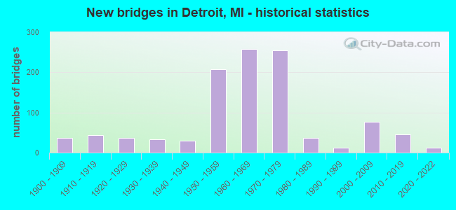
- New bridges - historical statistics
- 1Before 1900
- 371900-1909
- 431910-1919
- 371920-1929
- 331930-1939
- 291940-1949
- 2071950-1959
- 2591960-1969
- 2551970-1979
- 361980-1989
- 131990-1999
- 762000-2009
- 462010-2019
- 132020-2022
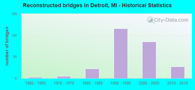
- Reconstructed bridges - Historical Statistics
- 31960-1969
- 51970-1979
- 221980-1989
- 1161990-1999
- 852000-2009
- 272010-2019
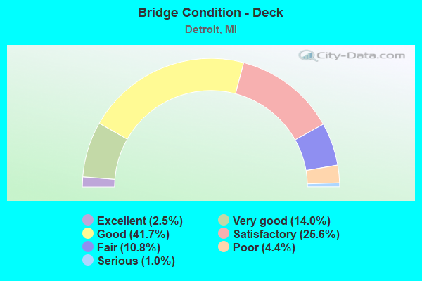
- Bridge Condition - Deck
- 2.5%Excellent
- 14.0%Very good
- 41.7%Good
- 25.6%Satisfactory
- 10.8%Fair
- 4.4%Poor
- 1.0%Serious
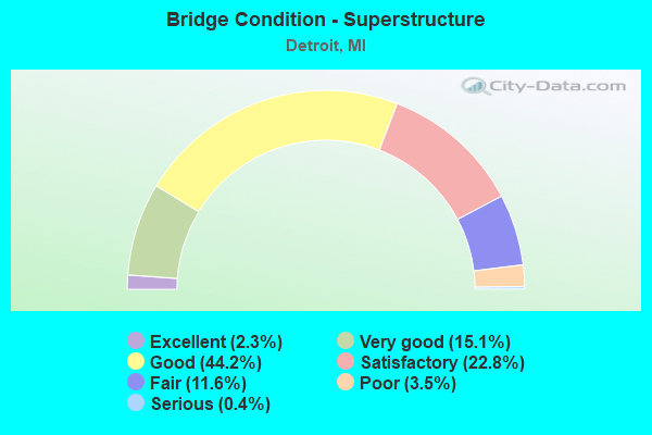
- Bridge Condition - Superstructure
- 2.3%Excellent
- 15.1%Very good
- 44.2%Good
- 22.8%Satisfactory
- 11.6%Fair
- 3.5%Poor
- 0.4%Serious
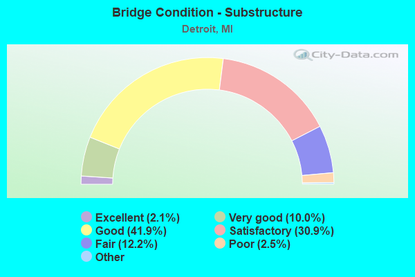
- Bridge Condition - Substructure
- 2.1%Excellent
- 10.0%Very good
- 41.9%Good
- 30.9%Satisfactory
- 12.2%Fair
- 2.5%Poor
- 0.4%Serious
- 0.2%Failed
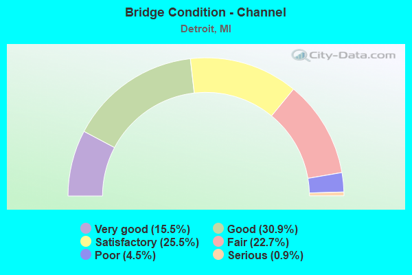
- Bridge Condition - Channel
- 15.5%Very good
- 30.9%Good
- 25.5%Satisfactory
- 22.7%Fair
- 4.5%Poor
- 0.9%Serious
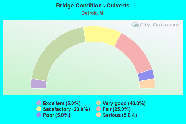
- Bridge Condition - Culverts
- 5.0%Excellent
- 40.0%Very good
- 20.0%Satisfactory
- 25.0%Fair
- 5.0%Poor
- 5.0%Serious
Find on map >> Show street view
Structure Number: 11429, Location: IN DETROIT (Lat: 42.372031, Lng: -83.084958), Route carried "on" structure: City street , Year Built: 1954, Year Reconstructed: 2000, Status: Open, Structure Length: 4.36m (14.30ft), Average Daily Traffic: 3,190 (year 2007), Average Future Daily Traffic: 3,509 (year 2022), Design Load: HS 20, Features Intersected: M-10, Facility Carried by Structure: SEWARD AVENUE
Minimum Vertical Clearance: 30.48m (100.00ft), Kilometerpoint: 0.430, Lanes on structure: 4, Lanes under structure: 8, Owner: State Highway Agency, Approaching Roadway Width: 13.4m (44.0ft), Material/Design: Steel continuous, Design/Construction: Stringer/Multi-beam, Number Of Spans In Main Unit: 2, Length of Maximum Span: 23.1m (75.8ft), Curb or Sidewalk Widths: Left: 3.7m (12.1ft), Right: 3.7m (12.1ft), Curb-To-Curb Width: 13.4m (44.0ft), Out-to-Out Width: 21.8m (71.5ft)
Condition: Deck: Very good, Superstructure: Good, Substructure: Satisfactory, Operating Rating: 65.8 metric tons, Method Used To Determine Operating Rating: Load Factor (LF) rating reported by rating factor (RF) method using MS18 loading, Inventory Rating: 39.2 metric tons, Method Used To Determine Inventory Rating: Load Factor (LF) rating reported by rating factor (RF) method using MS18 loading, Structural Evaluation: Equal to present minimum criteria, Deck Geometry: High priority of replacement, Underclear: High priority of corrective action, Approach Roadway Alignment: Equal to present desirable criteria, Length Of Structure Improvement: 4.36m (14.30ft), Designated Inspection Frequency: Every 24 months, Inspection Date: September 2020, Bridge Improvement Cost: $208,000, Roadway Improvement Cost: $4,000, Total Project Cost: $42,000, Deck Structure Type: Concrete Cast-file-Place, Wearing Surface/Protective System: Wearing Surface: Integral Concrete, Deck Protection: Epoxy Coated Reinforcing
Find on map >> Show street view
Structure Number: 1143, Location: IN DETROIT (Lat: 42.374053, Lng: -83.086358), Route carried "on" structure: City street , Year Built: 1954, Year Reconstructed: 2000, Status: Open, Structure Length: 4.37m (14.34ft), Average Daily Traffic: 6,640 (year 1978), Truck Traffic: 1%, Average Future Daily Traffic: 6,640 (year 1998), Design Load: HS 20, Features Intersected: M-10, Facility Carried by Structure: EUCLID AVENUE
Minimum Vertical Clearance: 30.48m (100.00ft), Kilometerpoint: 3.130, Lanes on structure: 4, Lanes under structure: 8, Owner: State Highway Agency, Approaching Roadway Width: 13.4m (44.0ft), Material/Design: Steel continuous, Design/Construction: Stringer/Multi-beam, Number Of Spans In Main Unit: 2, Length of Maximum Span: 23.2m (76.1ft), Curb or Sidewalk Widths: Left: 3.7m (12.1ft), Right: 3.7m (12.1ft), Curb-To-Curb Width: 13.4m (44.0ft), Out-to-Out Width: 21.8m (71.5ft)
Condition: Deck: Very good, Superstructure: Good, Substructure: Good, Operating Rating: 77.1 metric tons, Method Used To Determine Operating Rating: Load Factor (LF) rating reported by rating factor (RF) method using MS18 loading, Inventory Rating: 46.3 metric tons, Method Used To Determine Inventory Rating: Load Factor (LF) rating reported by rating factor (RF) method using MS18 loading, Structural Evaluation: Better than present minimum criteria, Deck Geometry: High priority of replacement, Underclear: High priority of corrective action, Approach Roadway Alignment: Equal to present desirable criteria, Designated Inspection Frequency: Every 24 months, Inspection Date: September 2020, Deck Structure Type: Concrete Cast-file-Place, Wearing Surface/Protective System: Wearing Surface: Integral Concrete, Deck Protection: Epoxy Coated Reinforcing
Find on map >> Show street view
Structure Number: 11431, Location: IN DETROIT (Lat: 42.379717, Lng: -83.090219), Route carried "on" structure: City street 2000, Year Built: 1954, Year Reconstructed: 1995, Status: Open, Structure Length: 4.13m (13.55ft), Average Daily Traffic: 16,000 (year 1993), Average Future Daily Traffic: 18,690 (year 2013), Design Load: HS 20, Features Intersected: M-10, Facility Carried by Structure: CLAIRMOUNT AVENUE
Minimum Vertical Clearance: 30.48m (100.00ft), Kilometerpoint: 1.663, Lanes on structure: 3, Lanes under structure: 8, Owner: State Highway Agency, Approaching Roadway Width: 12.2m (40.0ft), Skew: 20 degrees, Material/Design: Steel continuous, Design/Construction: Stringer/Multi-beam, Number Of Spans In Main Unit: 2, Length of Maximum Span: 20.3m (66.6ft), Curb or Sidewalk Widths: Left: 3.1m (10.2ft), Right: 1.2m (3.9ft), Curb-To-Curb Width: 18.0m (59.1ft), Out-to-Out Width: 27.0m (88.6ft)
Condition: Deck: Satisfactory, Superstructure: Good, Substructure: Satisfactory, Operating Rating: 55.1 metric tons, Method Used To Determine Operating Rating: Load Factor (LF) rating reported by rating factor (RF) method using MS18 loading, Inventory Rating: 21.4 metric tons, Method Used To Determine Inventory Rating: Load Factor (LF) rating reported by rating factor (RF) method using MS18 loading, Structural Evaluation: Somewhat better than minimum adequacy, Deck Geometry: Superior to present desirable criteria, Underclear: High priority of corrective action, Approach Roadway Alignment: Equal to present desirable criteria, Designated Inspection Frequency: Every 24 months, Inspection Date: April 2021, Deck Structure Type: Concrete Cast-file-Place, Wearing Surface/Protective System: Wearing Surface: Monolithic Concrete, Deck Protection: Epoxy Coated Reinforcing
Find on map >> Show street view
Structure Number: 11432, Location: 0.1 MI E OF CHICAGO BLVD (Lat: 42.381358, Lng: -83.092267), Route carried "on" structure: City street 2000, Year Built: 1954, Year Reconstructed: 1994, Status: Open, Structure Length: 8.48m (27.82ft), Average Daily Traffic: 15,300 (year 1993), Average Future Daily Traffic: 15,300 (year 2013), Design Load: HS 20, Features Intersected: M-10, Facility Carried by Structure: HAMILTON AVENUE
Minimum Vertical Clearance: 30.48m (100.00ft), Kilometerpoint: 0.056, Lanes on structure: 3, Lanes under structure: 7, Owner: State Highway Agency, Approaching Roadway Width: 10.0m (32.8ft), Skew: 5 degrees, Material/Design: Steel, Design/Construction: Stringer/Multi-beam, Number Of Spans In Main Unit: 4, Length of Maximum Span: 32.7m (107.3ft), Curb or Sidewalk Widths: Left: 1.2m (3.9ft), Right: 3.1m (10.2ft), Curb-To-Curb Width: 10.1m (33.1ft), Out-to-Out Width: 15.5m (50.9ft)
Condition: Deck: Good, Superstructure: Good, Substructure: Satisfactory, Operating Rating: 58.3 metric tons, Method Used To Determine Operating Rating: Load Factor (LF) rating reported by rating factor (RF) method using MS18 loading, Inventory Rating: 35.0 metric tons, Method Used To Determine Inventory Rating: Load Factor (LF) rating reported by rating factor (RF) method using MS18 loading, Structural Evaluation: Equal to present minimum criteria, Deck Geometry: High priority of replacement, Underclear: High priority of corrective action, Approach Roadway Alignment: Better than present minimum criteria, Designated Inspection Frequency: Every 24 months, Inspection Date: June 2020, Bridge Improvement Cost: $108,000, Deck Structure Type: Concrete Cast-file-Place, Wearing Surface/Protective System: Wearing Surface: Monolithic Concrete, Deck Protection: Epoxy Coated Reinforcing
Find on map >> Show street view
Structure Number: 11433, Location: IN DETROIT (Lat: 42.382411, Lng: -83.094647), Route carried "on" structure: City street 2000, Year Built: 1955, Year Reconstructed: 1994, Status: Open, Structure Length: 6.85m (22.47ft), Average Daily Traffic: 14,000 (year 1993), Average Future Daily Traffic: 17,540 (year 2013), Design Load: HS 20, Features Intersected: M-10, Facility Carried by Structure: CHICAGO BLVD
Minimum Vertical Clearance: 30.48m (100.00ft), Kilometerpoint: 1.943, Lanes on structure: 6, Lanes under structure: 6, Owner: State Highway Agency, Approaching Roadway Width: 10.0m (32.8ft), Skew: 24 degrees, Material/Design: Steel continuous, Design/Construction: Stringer/Multi-beam, Number Of Spans In Main Unit: 4, Length of Maximum Span: 22.6m (74.1ft), Curb or Sidewalk Widths: Left: 3.1m (10.2ft), Right: 3.1m (10.2ft), Curb-To-Curb Width: 20.1m (65.9ft), Out-to-Out Width: 35.9m (117.8ft)
Condition: Deck: Good, Superstructure: Fair, Substructure: Satisfactory, Operating Rating: 68.5 metric tons, Method Used To Determine Operating Rating: Load Factor (LF), Inventory Rating: 41.2 metric tons, Method Used To Determine Inventory Rating: Load Factor (LF), Structural Evaluation: Somewhat better than minimum adequacy, Deck Geometry: High priority of replacement, Underclear: High priority of corrective action, Approach Roadway Alignment: Equal to present desirable criteria, Designated Inspection Frequency: Every 24 months, Inspection Date: April 2021, Deck Structure Type: Concrete Cast-file-Place, Wearing Surface/Protective System: Wearing Surface: Monolithic Concrete
Find on map >> Show street view
Structure Number: 11434, Location: IN DETROIT (Lat: 42.384483, Lng: -83.099550), Route carried "on" structure: City street , Year Built: 1955, Year Reconstructed: 1991, Status: Open, Structure Length: 5.20m (17.06ft), Average Daily Traffic: 1,990 (year 1990), Average Future Daily Traffic: 1,990 (year 2010), Design Load: HS 20, Features Intersected: M-10, Facility Carried by Structure: CALVERT AVE
Minimum Vertical Clearance: 30.48m (100.00ft), Kilometerpoint: 2.189, Lanes on structure: 4, Lanes under structure: 6, Owner: State Highway Agency, Approaching Roadway Width: 12.2m (40.0ft), Skew: 1 degrees, Material/Design: Steel continuous, Design/Construction: Stringer/Multi-beam, Number Of Spans In Main Unit: 4, Length of Maximum Span: 17.4m (57.1ft), Curb or Sidewalk Widths: Left: 3.3m (10.8ft), Right: 3.3m (10.8ft), Curb-To-Curb Width: 13.4m (44.0ft), Out-to-Out Width: 20.7m (67.9ft)
Condition: Deck: Satisfactory, Superstructure: Satisfactory, Substructure: Fair, Operating Rating: 62.9 metric tons, Method Used To Determine Operating Rating: Load Factor (LF) rating reported by rating factor (RF) method using MS18 loading, Inventory Rating: 37.6 metric tons, Method Used To Determine Inventory Rating: Load Factor (LF) rating reported by rating factor (RF) method using MS18 loading, Structural Evaluation: Somewhat better than minimum adequacy, Deck Geometry: High priority of replacement, Underclear: High priority of corrective action, Approach Roadway Alignment: Better than present minimum criteria, Designated Inspection Frequency: Every 24 months, Inspection Date: December 2021, Deck Structure Type: Concrete Cast-file-Place, Wearing Surface/Protective System: Wearing Surface: Latex Concrete, Deck Protection: Epoxy Coated Reinforcing
Find on map >> Show street view
Structure Number: 11435, Location: IN DETROIT (Lat: 42.387842, Lng: -83.102111), Route carried "on" structure: City street 2000, Year Built: 1955, Year Reconstructed: 1991, Status: Temporarily open, Structure Length: 5.06m (16.60ft), Average Daily Traffic: 9,260 (year 1990), Average Future Daily Traffic: 12,470 (year 2015), Design Load: HS 20, Features Intersected: M-10, Facility Carried by Structure: WEBB AVE
Minimum Vertical Clearance: 30.48m (100.00ft), Kilometerpoint: 0.370, Lanes on structure: 5, Lanes under structure: 6, Owner: State Highway Agency, Approaching Roadway Width: 15.8m (51.8ft), Material/Design: Steel continuous, Design/Construction: Stringer/Multi-beam, Number Of Spans In Main Unit: 4, Length of Maximum Span: 16.7m (54.8ft), Curb or Sidewalk Widths: Left: 3.3m (10.8ft), Right: 3.3m (10.8ft), Curb-To-Curb Width: 15.8m (51.8ft), Out-to-Out Width: 23.2m (76.1ft)
Condition: Deck: Satisfactory, Superstructure: Fair, Substructure: Satisfactory, Structural Evaluation: High priority of corrective action, Deck Geometry: High priority of replacement, Underclear: High priority of corrective action, Approach Roadway Alignment: Equal to present desirable criteria, Designated Inspection Frequency: Every 24 months, Inspection Date: April 2021, Deck Structure Type: Concrete Cast-file-Place, Wearing Surface/Protective System: Wearing Surface: Monolithic Concrete, Deck Protection: Epoxy Coated Reinforcing
Find on map >> Show street view
Structure Number: 11436, Location: IN DETROIT (Lat: 42.394889, Lng: -83.107208), Route carried "on" structure: City street 2000, Year Built: 1955, Year Reconstructed: 2006, Status: Open, Structure Length: 5.17m (16.96ft), Average Daily Traffic: 3,654 (year 2010), Average Future Daily Traffic: 4,019 (year 2025), Design Load: HS 20+Mod, Features Intersected: M-10, Facility Carried by Structure: GLENDALE AVE
Minimum Vertical Clearance: 30.48m (100.00ft), Kilometerpoint: 0.351, Lanes on structure: 4, Lanes under structure: 6, Owner: State Highway Agency, Approaching Roadway Width: 13.4m (44.0ft), Material/Design: Steel continuous, Design/Construction: Stringer/Multi-beam, Number Of Spans In Main Unit: 4, Length of Maximum Span: 17.1m (56.1ft), Curb or Sidewalk Widths: Left: 2.0m (6.6ft), Right: 2.0m (6.6ft), Curb-To-Curb Width: 15.8m (51.8ft), Out-to-Out Width: 20.7m (67.9ft)
Condition: Deck: Very good, Superstructure: Good, Substructure: Good, Operating Rating: 82.0 metric tons, Method Used To Determine Operating Rating: Load Factor (LF) rating reported by rating factor (RF) method using MS18 loading, Inventory Rating: 49.2 metric tons, Method Used To Determine Inventory Rating: Load Factor (LF) rating reported by rating factor (RF) method using MS18 loading, Structural Evaluation: Better than present minimum criteria, Deck Geometry: Meets minimum limits, Underclear: High priority of corrective action, Approach Roadway Alignment: Equal to present desirable criteria, Designated Inspection Frequency: Every 24 months, Inspection Date: December 2020, Deck Structure Type: Concrete Cast-file-Place, Wearing Surface/Protective System: Wearing Surface: Monolithic Concrete, Deck Protection: Epoxy Coated Reinforcing
Find on map >> Show street view
Structure Number: 11437, Location: IN DETROIT OVER M-10 SB (Lat: 42.398167, Lng: -83.110103), Route carried "on" structure: State highway 8, Year Built: 1956, Year Reconstructed: 1996, Status: Open, Structure Length: 6.67m (21.88ft), Average Daily Traffic: 39,515 (year 2007), Truck Traffic: 2%, Average Future Daily Traffic: 40,985 (year 2018), Design Load: HS 25 or greater, Features Intersected: M-10 SB
Minimum Vertical Clearance: 30.48m (100.00ft), Kilometerpoint: 4.342, Lanes on structure: 2, Lanes under structure: 4, Base Highway Network: Yes (Inventory Route: 470, Subroute: 9), Owner: State Highway Agency, Approaching Roadway Width: 10.0m (32.8ft), Skew: 9 degrees, Material/Design: Steel, Design/Construction: Stringer/Multi-beam, Number Of Spans In Main Unit: 5, Length of Maximum Span: 22.5m (73.8ft), Curb-To-Curb Width: 13.5m (44.3ft), Out-to-Out Width: 14.5m (47.6ft)
Condition: Deck: Good, Superstructure: Good, Substructure: Good, Operating Rating: 82.0 metric tons, Method Used To Determine Operating Rating: Load Factor (LF) rating reported by rating factor (RF) method using MS18 loading, Inventory Rating: 48.9 metric tons, Method Used To Determine Inventory Rating: Load Factor (LF) rating reported by rating factor (RF) method using MS18 loading, Structural Evaluation: Better than present minimum criteria, Deck Geometry: Superior to present desirable criteria, Underclear: Meets minimum limits, Approach Roadway Alignment: Equal to present desirable criteria, Designated Inspection Frequency: Every 24 months, Inspection Date: April 2021, Deck Structure Type: Concrete Cast-file-Place, Wearing Surface/Protective System: Wearing Surface: Monolithic Concrete, Deck Protection: Epoxy Coated Reinforcing
Find on map >> Show street view
Structure Number: 11438, Location: IN DETROIT (Lat: 42.398306, Lng: -83.109694), Route carried "on" structure: State highway 10, Year Built: 1956, Year Reconstructed: 1987, Status: Open, Structure Length: 9.19m (30.15ft), Average Daily Traffic: 78,042 (year 2007), Truck Traffic: 2%, Average Future Daily Traffic: 67,469 (year 2018), Design Load: HS 20, Features Intersected: M-8 DAVISON
Minimum Vertical Clearance: 30.48m (100.00ft), Kilometerpoint: 10.085, Lanes on structure: 4, Lanes under structure: 7, Base Highway Network: Yes (Inventory Route: 157, Subroute: 10), Owner: State Highway Agency, Approaching Roadway Width: 15.5m (50.9ft), Skew: 1 degrees, Material/Design: Steel, Design/Construction: Stringer/Multi-beam, Number Of Spans In Main Unit: 8, Length of Maximum Span: 21.7m (71.2ft), Curb-To-Curb Width: 21.0m (68.9ft), Out-to-Out Width: 22.2m (72.8ft)
Condition: Deck: Satisfactory, Superstructure: Good, Substructure: Good, Operating Rating: 76.1 metric tons, Method Used To Determine Operating Rating: Load Factor (LF) rating reported by rating factor (RF) method using MS18 loading, Inventory Rating: 45.4 metric tons, Method Used To Determine Inventory Rating: Load Factor (LF) rating reported by rating factor (RF) method using MS18 loading, Structural Evaluation: Better than present minimum criteria, Deck Geometry: Better than present minimum criteria, Underclear: High priority of corrective action, Approach Roadway Alignment: Better than present minimum criteria, Designated Inspection Frequency: Every 24 months, Inspection Date: November 2021, Deck Structure Type: Concrete Cast-file-Place, Wearing Surface/Protective System: Wearing Surface: Monolithic Concrete, Deck Protection: Epoxy Coated Reinforcing
Find on map >> Show street view
Structure Number: 11439, Location: IN DETROIT (Lat: 42.398683, Lng: -83.108642), Route carried "on" structure: Ramp State highway 10, Year Built: 1957, Year Reconstructed: 1996, Status: Open, Structure Length: 9.20m (30.18ft), Average Daily Traffic: 17,840 (year 1982), Average Future Daily Traffic: 20,516 (year 2002), Design Load: HS 20, Features Intersected: M-8 EB DAVISON
Minimum Vertical Clearance: 30.48m (100.00ft), Kilometerpoint: 0.219, Lanes on structure: 1, Lanes under structure: 4, Owner: State Highway Agency, Approaching Roadway Width: 7.0m (23.0ft), Skew: 6 degrees, Material/Design: Steel, Design/Construction: Stringer/Multi-beam, Number Of Spans In Main Unit: 4, Length of Maximum Span: 37.5m (123.0ft), Curb-To-Curb Width: 7.7m (25.3ft), Out-to-Out Width: 8.7m (28.5ft)
Condition: Deck: Good, Superstructure: Satisfactory, Substructure: Satisfactory, Operating Rating: 66.1 metric tons, Method Used To Determine Operating Rating: Load Factor (LF) rating reported by rating factor (RF) method using MS18 loading, Inventory Rating: 39.5 metric tons, Method Used To Determine Inventory Rating: Load Factor (LF) rating reported by rating factor (RF) method using MS18 loading, Structural Evaluation: Equal to present minimum criteria, Deck Geometry: Better than present minimum criteria, Underclear: High priority of corrective action, Approach Roadway Alignment: Equal to present desirable criteria, Designated Inspection Frequency: Every 24 months, Inspection Date: April 2021, Deck Structure Type: Concrete Cast-file-Place, Wearing Surface/Protective System: Wearing Surface: Monolithic Concrete, Deck Protection: Epoxy Coated Reinforcing
Find on map >> Show street view
Structure Number: 1144, Location: IN DETROIT (Lat: 42.398239, Lng: -83.110358), Route carried "on" structure: State highway 8, Year Built: 1956, Year Reconstructed: 1996, Status: Open, Structure Length: 6.49m (21.29ft), Average Daily Traffic: 39,515 (year 2007), Truck Traffic: 2%, Average Future Daily Traffic: 40,985 (year 2018), Design Load: HS 20, Features Intersected: M-10 SB
Minimum Vertical Clearance: 30.48m (100.00ft), Kilometerpoint: 0.295, Lanes on structure: 2, Lanes under structure: 4, Base Highway Network: Yes (Inventory Route: 470, Subroute: 11), Owner: State Highway Agency, Approaching Roadway Width: 10.0m (32.8ft), Skew: 1 degrees, Material/Design: Steel, Design/Construction: Stringer/Multi-beam, Number Of Spans In Main Unit: 4, Length of Maximum Span: 22.8m (74.8ft), Curb-To-Curb Width: 13.5m (44.3ft), Out-to-Out Width: 14.6m (47.9ft)
Condition: Deck: Good, Superstructure: Good, Substructure: Good, Operating Rating: 75.8 metric tons, Method Used To Determine Operating Rating: Load Factor (LF) rating reported by rating factor (RF) method using MS18 loading, Inventory Rating: 30.8 metric tons, Method Used To Determine Inventory Rating: Load Factor (LF) rating reported by rating factor (RF) method using MS18 loading, Structural Evaluation: Better than present minimum criteria, Deck Geometry: Superior to present desirable criteria, Underclear: Equal to present minimum criteria, Approach Roadway Alignment: Equal to present desirable criteria, Designated Inspection Frequency: Every 24 months, Inspection Date: April 2021, Deck Structure Type: Concrete Cast-file-Place, Wearing Surface/Protective System: Wearing Surface: Monolithic Concrete, Deck Protection: Epoxy Coated Reinforcing
Find on map >> Show street view
Structure Number: 11441, Location: IN DETROIT (Lat: 42.398850, Lng: -83.111458), Route carried "on" structure: Ramp State highway 14, Year Built: 1957, Year Reconstructed: 2006, Status: Open, Structure Length: 5.35m (17.55ft), Average Daily Traffic: 42,500 (year 1995), Truck Traffic: 3%, Average Future Daily Traffic: 48,875 (year 2015), Design Load: HS 25 or greater, Features Intersected: M-10 SB, Facility Carried by Structure: NB TO WB DAVISON
Minimum Vertical Clearance: 30.48m (100.00ft), Kilometerpoint: 0.137, Lanes on structure: 1, Lanes under structure: 4, Owner: State Highway Agency, Approaching Roadway Width: 8.5m (27.9ft), Material/Design: Steel, Design/Construction: Stringer/Multi-beam, Number Of Spans In Main Unit: 3, Length of Maximum Span: 25.9m (85.0ft), Curb-To-Curb Width: 8.8m (28.9ft), Out-to-Out Width: 9.8m (32.2ft)
Condition: Deck: Good, Superstructure: Good, Substructure: Good, Operating Rating: 73.9 metric tons, Method Used To Determine Operating Rating: Load Factor (LF) rating reported by rating factor (RF) method using MS18 loading, Inventory Rating: 44.4 metric tons, Method Used To Determine Inventory Rating: Load Factor (LF) rating reported by rating factor (RF) method using MS18 loading, Structural Evaluation: Better than present minimum criteria, Deck Geometry: Superior to present desirable criteria, Underclear: Equal to present minimum criteria, Approach Roadway Alignment: Equal to present desirable criteria, Designated Inspection Frequency: Every 24 months, Inspection Date: April 2021, Deck Structure Type: Concrete Cast-file-Place, Wearing Surface/Protective System: Wearing Surface: Monolithic Concrete, Deck Protection: Epoxy Coated Reinforcing
Find on map >> Show street view
Structure Number: 11442, Location: IN DETROIT (Lat: 42.401672, Lng: -83.115539), Route carried "on" structure: City street 2000, Year Built: 1955, Year Reconstructed: 2000, Status: Open, Structure Length: 4.51m (14.80ft), Average Daily Traffic: 12,660 (year 2010), Truck Traffic: 3%, Average Future Daily Traffic: 13,926 (year 2025), Design Load: HS 20, Features Intersected: M-10, Facility Carried by Structure: OAKMAN BLVD
Minimum Vertical Clearance: 30.48m (100.00ft), Kilometerpoint: 5.638, Lanes on structure: 4, Lanes under structure: 7, Owner: State Highway Agency, Approaching Roadway Width: 9.1m (29.9ft), Skew: 22 degrees, Material/Design: Steel continuous, Design/Construction: Stringer/Multi-beam, Number Of Spans In Main Unit: 2, Length of Maximum Span: 22.5m (73.8ft), Curb or Sidewalk Widths: Left: 5.2m (17.1ft), Right: 5.2m (17.1ft), Curb-To-Curb Width: 18.3m (60.0ft), Out-to-Out Width: 37.3m (122.4ft)
Condition: Deck: Good, Superstructure: Good, Substructure: Good, Operating Rating: 75.8 metric tons, Method Used To Determine Operating Rating: Load Factor (LF) rating reported by rating factor (RF) method using MS18 loading, Inventory Rating: 45.4 metric tons, Method Used To Determine Inventory Rating: Load Factor (LF) rating reported by rating factor (RF) method using MS18 loading, Structural Evaluation: Better than present minimum criteria, Deck Geometry: Somewhat better than minimum adequacy, Underclear: High priority of corrective action, Approach Roadway Alignment: Equal to present desirable criteria, Designated Inspection Frequency: Every 24 months, Inspection Date: April 2021, Bridge Improvement Cost: $643,000, Deck Structure Type: Concrete Cast-file-Place, Wearing Surface/Protective System: Wearing Surface: Integral Concrete, Deck Protection: Epoxy Coated Reinforcing
Find on map >> Show street view
Structure Number: 11443, Location: IN DETROIT (Lat: 42.403333, Lng: -83.118061), Route carried "on" structure: City street , Year Built: 1957, Year Reconstructed: 1995, Status: Open, Structure Length: 4.29m (14.07ft), Average Daily Traffic: 5,948 (year 2010), Average Future Daily Traffic: 6,543 (year 2025), Design Load: HS 20, Features Intersected: M-10, Facility Carried by Structure: ROSA PARKS BLVD
Minimum Vertical Clearance: 30.48m (100.00ft), Kilometerpoint: 0.021, Lanes on structure: 4, Lanes under structure: 7, Owner: State Highway Agency, Approaching Roadway Width: 13.4m (44.0ft), Skew: 1 degrees, Material/Design: Steel continuous, Design/Construction: Stringer/Multi-beam, Number Of Spans In Main Unit: 2, Length of Maximum Span: 21.3m (69.9ft), Curb or Sidewalk Widths: Left: 3.3m (10.8ft), Right: 3.3m (10.8ft), Curb-To-Curb Width: 13.4m (44.0ft), Out-to-Out Width: 20.7m (67.9ft)
Condition: Deck: Good, Superstructure: Satisfactory, Substructure: Satisfactory, Operating Rating: 57.3 metric tons, Method Used To Determine Operating Rating: Load Factor (LF) rating reported by rating factor (RF) method using MS18 loading, Inventory Rating: 34.3 metric tons, Method Used To Determine Inventory Rating: Load Factor (LF) rating reported by rating factor (RF) method using MS18 loading, Structural Evaluation: Equal to present minimum criteria, Deck Geometry: High priority of replacement, Underclear: High priority of corrective action, Approach Roadway Alignment: Equal to present minimum criteria, Designated Inspection Frequency: Every 24 months, Inspection Date: April 2021, Deck Structure Type: Concrete Cast-file-Place, Wearing Surface/Protective System: Wearing Surface: Monolithic Concrete, Deck Protection: Epoxy Coated Reinforcing
Find on map >> Show street view
Structure Number: 11444, Location: IN DETROIT (Lat: 42.405081, Lng: -83.127400), Route carried "on" structure: City street 2000, Year Built: 1955, Year Reconstructed: 1994, Status: Open, Structure Length: 5.09m (16.70ft), Average Daily Traffic: 13,680 (year 0000), Truck Traffic: 4%, Average Future Daily Traffic: 68,400 (year 2006), Design Load: HS 20, Features Intersected: M-10 JOHN LODGE FRWY, Facility Carried by Structure: LINWOOD AVE
Minimum Vertical Clearance: 30.48m (100.00ft), Kilometerpoint: 6.069, Lanes on structure: 4, Lanes under structure: 6, Owner: State Highway Agency, Approaching Roadway Width: 13.4m (44.0ft), Material/Design: Steel continuous, Design/Construction: Stringer/Multi-beam, Number Of Spans In Main Unit: 4, Length of Maximum Span: 16.7m (54.8ft), Curb or Sidewalk Widths: Left: 3.0m (9.8ft), Right: 3.0m (9.8ft), Curb-To-Curb Width: 14.6m (47.9ft), Out-to-Out Width: 21.9m (71.9ft)
Condition: Deck: Good, Superstructure: Good, Substructure: Satisfactory, Operating Rating: 56.1 metric tons, Method Used To Determine Operating Rating: Load Factor (LF) rating reported by rating factor (RF) method using MS18 loading, Inventory Rating: 33.7 metric tons, Method Used To Determine Inventory Rating: Load Factor (LF) rating reported by rating factor (RF) method using MS18 loading, Structural Evaluation: Equal to present minimum criteria, Deck Geometry: High priority of replacement, Underclear: High priority of corrective action, Approach Roadway Alignment: Equal to present desirable criteria, Designated Inspection Frequency: Every 24 months, Inspection Date: April 2021, Bridge Improvement Cost: $74,000, Deck Structure Type: Concrete Cast-file-Place, Wearing Surface/Protective System: Wearing Surface: Monolithic Concrete, Deck Protection: Epoxy Coated Reinforcing
Find on map >> Show street view
Structure Number: 11445, Location: IN DETROIT (Lat: 42.405019, Lng: -83.135522), Route carried "on" structure: City street , Year Built: 1955, Year Reconstructed: 1994, Status: Open, Structure Length: 5.27m (17.29ft), Average Daily Traffic: 7,310 (year 0000), Average Future Daily Traffic: 68,400 (year 2006), Design Load: HS 20, Features Intersected: M-10 JOHN LODGE FRWY, Facility Carried by Structure: DEXTER-BELDEN AVE
Minimum Vertical Clearance: 30.48m (100.00ft), Kilometerpoint: 0.237, Lanes on structure: 4, Lanes under structure: 6, Owner: State Highway Agency, Approaching Roadway Width: 10.0m (32.8ft), Skew: 1 degrees, Material/Design: Steel continuous, Design/Construction: Stringer/Multi-beam, Number Of Spans In Main Unit: 4, Length of Maximum Span: 17.7m (58.1ft), Curb or Sidewalk Widths: Left: 3.0m (9.8ft), Right: 3.0m (9.8ft), Curb-To-Curb Width: 13.4m (44.0ft), Out-to-Out Width: 20.7m (67.9ft)
Condition: Deck: Satisfactory, Superstructure: Satisfactory, Substructure: Good, Operating Rating: 72.3 metric tons, Method Used To Determine Operating Rating: Load Factor (LF) rating reported by rating factor (RF) method using MS18 loading, Inventory Rating: 43.1 metric tons, Method Used To Determine Inventory Rating: Load Factor (LF) rating reported by rating factor (RF) method using MS18 loading, Structural Evaluation: Equal to present minimum criteria, Deck Geometry: High priority of replacement, Underclear: High priority of corrective action, Approach Roadway Alignment: Equal to present desirable criteria, Designated Inspection Frequency: Every 24 months, Inspection Date: December 2020, Deck Structure Type: Concrete Cast-file-Place, Wearing Surface/Protective System: Wearing Surface: Monolithic Concrete, Deck Protection: Epoxy Coated Reinforcing
Find on map >> Show street view
Structure Number: 11446, Location: IN DETROIT (Lat: 42.404808, Lng: -83.140339), Route carried "on" structure: City street 2000, Year Built: 1955, Year Reconstructed: 2006, Status: Open, Structure Length: 3.73m (12.24ft), Average Daily Traffic: 48,080 (year 1995), Truck Traffic: 3%, Average Future Daily Traffic: 48,080 (year 2015), Design Load: HS 20, Features Intersected: M-10, Facility Carried by Structure: LIVERNOIS AVE
Minimum Vertical Clearance: 30.48m (100.00ft), Kilometerpoint: 12.442, Lanes on structure: 8, Lanes under structure: 6, Base Highway Network: Yes (Inventory Route: 158, Subroute: 1), Owner: State Highway Agency, Approaching Roadway Width: 28.6m (93.8ft), Material/Design: Steel continuous, Design/Construction: Stringer/Multi-beam, Number Of Spans In Main Unit: 2, Length of Maximum Span: 19.8m (65.0ft), Curb or Sidewalk Widths: Left: 4.0m (13.1ft), Right: 4.0m (13.1ft), Curb-To-Curb Width: 28.7m (94.2ft), Out-to-Out Width: 37.6m (123.4ft)
Condition: Deck: Very good, Superstructure: Good, Substructure: Good, Operating Rating: 59.9 metric tons, Method Used To Determine Operating Rating: Load Factor (LF) rating reported by rating factor (RF) method using MS18 loading, Inventory Rating: 36.0 metric tons, Method Used To Determine Inventory Rating: Load Factor (LF) rating reported by rating factor (RF) method using MS18 loading, Structural Evaluation: Better than present minimum criteria, Deck Geometry: High priority of corrective action, Underclear: High priority of corrective action, Approach Roadway Alignment: Equal to present desirable criteria, Designated Inspection Frequency: Every 24 months, Inspection Date: December 2020, Deck Structure Type: Concrete Cast-file-Place, Wearing Surface/Protective System: Wearing Surface: Monolithic Concrete, Deck Protection: Epoxy Coated Reinforcing
Find on map >> Show street view
Structure Number: 11447, Location: IN DETROIT (Lat: 42.404717, Lng: -83.150603), Route carried "on" structure: City street , Year Built: 1955, Status: Open, Structure Length: 4.97m (16.31ft), Average Daily Traffic: 3,880 (year 2007), Average Future Daily Traffic: 4,268 (year 2022), Design Load: HS 20, Features Intersected: M-10, Facility Carried by Structure: GREENLAWN AVE
Minimum Vertical Clearance: 30.48m (100.00ft), Kilometerpoint: 0.238, Lanes on structure: 4, Lanes under structure: 6, Owner: State Highway Agency, Approaching Roadway Width: 10.0m (32.8ft), Material/Design: Steel continuous, Design/Construction: Stringer/Multi-beam, Number Of Spans In Main Unit: 4, Length of Maximum Span: 16.7m (54.8ft), Curb or Sidewalk Widths: Left: 3.3m (10.8ft), Right: 3.3m (10.8ft), Curb-To-Curb Width: 13.4m (44.0ft), Out-to-Out Width: 20.7m (67.9ft)
Condition: Deck: Fair, Superstructure: Fair, Substructure: Satisfactory, Operating Rating: 69.7 metric tons, Method Used To Determine Operating Rating: Load Factor (LF) rating reported by rating factor (RF) method using MS18 loading, Inventory Rating: 41.8 metric tons, Method Used To Determine Inventory Rating: Load Factor (LF) rating reported by rating factor (RF) method using MS18 loading, Structural Evaluation: Somewhat better than minimum adequacy, Deck Geometry: High priority of replacement, Underclear: High priority of corrective action, Approach Roadway Alignment: Better than present minimum criteria, Designated Inspection Frequency: Every 24 months, Inspection Date: August 2020, Deck Structure Type: Concrete Cast-file-Place, Wearing Surface/Protective System: Wearing Surface: Latex Concrete
Find on map >> Show street view
Structure Number: 11448, Location: IN DETROIT (Lat: 42.405003, Lng: -83.159803), Route carried "on" structure: City street 2000, Year Built: 1955, Year Reconstructed: 1989, Status: Open, Structure Length: 7.14m (23.43ft), Average Daily Traffic: 16,660 (year 2007), Truck Traffic: 3%, Average Future Daily Traffic: 18,326 (year 2022), Design Load: HS 20, Features Intersected: M-10, Facility Carried by Structure: WYOMING AVE
Minimum Vertical Clearance: 30.48m (100.00ft), Kilometerpoint: 8.359, Lanes on structure: 5, Lanes under structure: 5, Base Highway Network: Yes (Inventory Route: 470, Subroute: 1), Owner: State Highway Agency, Approaching Roadway Width: 17.0m (55.8ft), Skew: 2 degrees, Material/Design: Steel continuous, Design/Construction: Stringer/Multi-beam, Number Of Spans In Main Unit: 5, Length of Maximum Span: 18.9m (62.0ft), Curb or Sidewalk Widths: Left: 3.3m (10.8ft), Right: 3.3m (10.8ft), Curb-To-Curb Width: 17.0m (55.8ft), Out-to-Out Width: 24.3m (79.7ft)
Condition: Deck: Satisfactory, Superstructure: Satisfactory, Substructure: Satisfactory, Operating Rating: 54.1 metric tons, Method Used To Determine Operating Rating: Load Factor (LF) rating reported by rating factor (RF) method using MS18 loading, Inventory Rating: 32.4 metric tons, Method Used To Determine Inventory Rating: Load Factor (LF) rating reported by rating factor (RF) method using MS18 loading, Structural Evaluation: Equal to present minimum criteria, Deck Geometry: High priority of replacement, Underclear: High priority of corrective action, Approach Roadway Alignment: Better than present minimum criteria, Designated Inspection Frequency: Every 24 months, Inspection Date: August 2020, Deck Structure Type: Concrete Cast-file-Place, Wearing Surface/Protective System: Wearing Surface: Monolithic Concrete, Deck Protection: Epoxy Coated Reinforcing
Find on map >> Show street view
Structure Number: 11449, Location: IN DETROIT (Lat: 42.409619, Lng: -83.164975), Route carried "on" structure: City street 2000, Year Built: 1963, Year Reconstructed: 2006, Status: Open, Structure Length: 4.05m (13.29ft), Average Daily Traffic: 17,830 (year 1995), Truck Traffic: 3%, Average Future Daily Traffic: 17,830 (year 2015), Design Load: HS 20, Features Intersected: M-10, Facility Carried by Structure: PURITAN AVE
Minimum Vertical Clearance: 30.48m (100.00ft), Kilometerpoint: 5.237, Lanes on structure: 4, Lanes under structure: 6, Owner: State Highway Agency, Approaching Roadway Width: 13.4m (44.0ft), Skew: 33 degrees, Material/Design: Steel, Design/Construction: Stringer/Multi-beam, Number Of Spans In Main Unit: 2, Length of Maximum Span: 20.4m (66.9ft), Curb or Sidewalk Widths: Left: 3.0m (9.8ft), Right: 3.0m (9.8ft), Curb-To-Curb Width: 25.6m (84.0ft), Out-to-Out Width: 32.4m (106.3ft)
Condition: Deck: Good, Superstructure: Good, Substructure: Good, Operating Rating: 61.9 metric tons, Method Used To Determine Operating Rating: Load Factor (LF) rating reported by rating factor (RF) method using MS18 loading, Inventory Rating: 36.9 metric tons, Method Used To Determine Inventory Rating: Load Factor (LF) rating reported by rating factor (RF) method using MS18 loading, Structural Evaluation: Better than present minimum criteria, Deck Geometry: Superior to present desirable criteria, Underclear: High priority of corrective action, Approach Roadway Alignment: Equal to present desirable criteria, Designated Inspection Frequency: Every 24 months, Inspection Date: August 2020, Deck Structure Type: Concrete Cast-file-Place, Wearing Surface/Protective System: Wearing Surface: Monolithic Concrete, Deck Protection: Epoxy Coated Reinforcing
Find on map >> Show street view
Structure Number: 1145, Location: IN DETROIT (Lat: 42.414167, Lng: -83.169981), Route carried "on" structure: City street 2000, Year Built: 1963, Status: Open, Structure Length: 6.36m (20.87ft), Average Daily Traffic: 12,690 (year 1995), Truck Traffic: 3%, Average Future Daily Traffic: 12,690 (year 2015), Design Load: HS 20, Features Intersected: M-10, Facility Carried by Structure: MYERS RD
Minimum Vertical Clearance: 30.48m (100.00ft), Kilometerpoint: 6.159, Lanes on structure: 4, Lanes under structure: 6, Owner: State Highway Agency, Approaching Roadway Width: 14.0m (45.9ft), Skew: 5 degrees, Material/Design: Steel, Design/Construction: Stringer/Multi-beam, Number Of Spans In Main Unit: 2, Length of Maximum Span: 31.8m (104.3ft), Curb or Sidewalk Widths: Left: 3.1m (10.2ft), Right: 3.1m (10.2ft), Curb-To-Curb Width: 16.5m (54.1ft), Out-to-Out Width: 23.9m (78.4ft)
Condition: Deck: Fair, Superstructure: Satisfactory, Substructure: Satisfactory, Operating Rating: 59.6 metric tons, Method Used To Determine Operating Rating: Load Factor (LF) rating reported by rating factor (RF) method using MS18 loading, Inventory Rating: 35.6 metric tons, Method Used To Determine Inventory Rating: Load Factor (LF) rating reported by rating factor (RF) method using MS18 loading, Structural Evaluation: Equal to present minimum criteria, Deck Geometry: Meets minimum limits, Underclear: High priority of corrective action, Approach Roadway Alignment: Equal to present desirable criteria, Designated Inspection Frequency: Every 24 months, Inspection Date: August 2020, Deck Structure Type: Concrete Cast-file-Place, Wearing Surface/Protective System: Wearing Surface: Bituminous
Find on map >> Show street view
Structure Number: 11451, Location: IN DETROIT (Lat: 42.413950, Lng: -83.169561), Route carried "on" structure: Ramp City street 2000, Year Built: 1963, Year Reconstructed: 2006, Status: Open, Structure Length: 3.38m (11.09ft), Average Daily Traffic: 3,000 (year 1978), Truck Traffic: 3%, Average Future Daily Traffic: 3,000 (year 1977), Design Load: HS 20, Features Intersected: M-10, Facility Carried by Structure: MYERS RD TURNAROUN
Minimum Vertical Clearance: 30.48m (100.00ft), Kilometerpoint: 0.032, Lanes on structure: 1, Lanes under structure: 6, Owner: State Highway Agency, Approaching Roadway Width: 14.0m (45.9ft), Material/Design: Steel, Design/Construction: Stringer/Multi-beam, Number Of Spans In Main Unit: 2, Length of Maximum Span: 16.9m (55.4ft), Curb-To-Curb Width: 6.1m (20.0ft), Out-to-Out Width: 6.8m (22.3ft)
Condition: Deck: Good, Superstructure: Good, Substructure: Good, Operating Rating: 82.2 metric tons, Method Used To Determine Operating Rating: Load Factor (LF), Inventory Rating: 49.2 metric tons, Method Used To Determine Inventory Rating: Load Factor (LF), Structural Evaluation: Better than present minimum criteria, Deck Geometry: Somewhat better than minimum adequacy, Underclear: High priority of corrective action, Approach Roadway Alignment: Equal to present desirable criteria, Designated Inspection Frequency: Every 24 months, Inspection Date: August 2020, Deck Structure Type: Concrete Cast-file-Place, Wearing Surface/Protective System: Wearing Surface: Monolithic Concrete, Deck Protection: Epoxy Coated Reinforcing
Find on map >> Show street view
Structure Number: 11452, Location: IN DETROIT (Lat: 42.416642, Lng: -83.172056), Route carried "on" structure: County highway 2057, Year Built: 1964, Year Reconstructed: 2006, Status: Open, Structure Length: 4.10m (13.45ft), Average Daily Traffic: 30,700 (year 1995), Truck Traffic: 3%, Average Future Daily Traffic: 30,700 (year 2015), Design Load: HS 20, Features Intersected: M-10, Facility Carried by Structure: MCNICHOLS RD
Minimum Vertical Clearance: 30.48m (100.00ft), Kilometerpoint: 31.187, Lanes on structure: 8, Lanes under structure: 6, Base Highway Network: Yes (Inventory Route: 168, Subroute: 1), Owner: State Highway Agency, Approaching Roadway Width: 17.6m (57.7ft), Skew: 33 degrees, Material/Design: Steel, Design/Construction: Stringer/Multi-beam, Number Of Spans In Main Unit: 2, Length of Maximum Span: 20.5m (67.3ft), Curb or Sidewalk Widths: Left: 3.0m (9.8ft), Right: 3.0m (9.8ft), Curb-To-Curb Width: 32.3m (106.0ft), Out-to-Out Width: 39.1m (128.3ft)
Condition: Deck: Satisfactory, Superstructure: Good, Substructure: Good, Operating Rating: 56.7 metric tons, Method Used To Determine Operating Rating: Load Factor (LF) rating reported by rating factor (RF) method using MS18 loading, Inventory Rating: 34.0 metric tons, Method Used To Determine Inventory Rating: Load Factor (LF) rating reported by rating factor (RF) method using MS18 loading, Structural Evaluation: Better than present minimum criteria, Deck Geometry: Somewhat better than minimum adequacy, Underclear: High priority of corrective action, Approach Roadway Alignment: Equal to present desirable criteria, Designated Inspection Frequency: Every 24 months, Inspection Date: April 2021, Deck Structure Type: Concrete Cast-file-Place, Wearing Surface/Protective System: Wearing Surface: Monolithic Concrete, Deck Protection: Epoxy Coated Reinforcing
Find on map >> Show street view
Structure Number: 11453, Location: IN DETROIT (Lat: 42.420908, Lng: -83.176089), Route carried "on" structure: County highway 2057, Year Built: 1964, Year Reconstructed: 2006, Status: Open, Structure Length: 3.35m (10.99ft), Average Daily Traffic: 17,900 (year 1995), Truck Traffic: 3%, Average Future Daily Traffic: 17,900 (year 2015), Design Load: HS 20, Features Intersected: M-10, Facility Carried by Structure: OUTER DRIVE EB
Minimum Vertical Clearance: 30.48m (100.00ft), Kilometerpoint: 4.625, Lanes on structure: 4, Lanes under structure: 6, Owner: State Highway Agency, Approaching Roadway Width: 10.0m (32.8ft), Material/Design: Steel, Design/Construction: Stringer/Multi-beam, Number Of Spans In Main Unit: 2, Length of Maximum Span: 16.8m (55.1ft), Curb or Sidewalk Widths: Left: 0.0m, Right: 2.7m (8.9ft), Curb-To-Curb Width: 14.6m (47.9ft), Out-to-Out Width: 18.0m (59.1ft)
Condition: Deck: Good, Superstructure: Good, Substructure: Good, Operating Rating: 69.3 metric tons, Method Used To Determine Operating Rating: Load Factor (LF) rating reported by rating factor (RF) method using MS18 loading, Inventory Rating: 41.5 metric tons, Method Used To Determine Inventory Rating: Load Factor (LF) rating reported by rating factor (RF) method using MS18 loading, Structural Evaluation: Better than present minimum criteria, Deck Geometry: High priority of replacement, Underclear: High priority of corrective action, Approach Roadway Alignment: Equal to present desirable criteria, Designated Inspection Frequency: Every 24 months, Inspection Date: August 2020, Deck Structure Type: Concrete Cast-file-Place, Wearing Surface/Protective System: Wearing Surface: Monolithic Concrete, Deck Protection: Epoxy Coated Reinforcing
Find on map >> Show street view
Structure Number: 11454, Location: IN DETROIT (Lat: 42.421075, Lng: -83.176244), Route carried "on" structure: County highway 2057, Year Built: 1964, Year Reconstructed: 2006, Status: Open, Structure Length: 3.35m (10.99ft), Average Daily Traffic: 20,250 (year 0000), Truck Traffic: 3%, Average Future Daily Traffic: 20,250 (year 2015), Design Load: HS 20, Features Intersected: M-10, Facility Carried by Structure: OUTER DRIVE WB
Minimum Vertical Clearance: 30.48m (100.00ft), Kilometerpoint: 4.434, Lanes on structure: 5, Lanes under structure: 6, Owner: State Highway Agency, Approaching Roadway Width: 10.0m (32.8ft), Skew: 30 degrees, Material/Design: Steel, Design/Construction: Stringer/Multi-beam, Number Of Spans In Main Unit: 2, Length of Maximum Span: 16.8m (55.1ft), Curb-To-Curb Width: 20.1m (65.9ft), Out-to-Out Width: 23.9m (78.4ft)
Condition: Deck: Good, Superstructure: Satisfactory, Substructure: Good, Operating Rating: 68.5 metric tons, Method Used To Determine Operating Rating: Load Factor (LF), Inventory Rating: 41.0 metric tons, Method Used To Determine Inventory Rating: Load Factor (LF), Structural Evaluation: Equal to present minimum criteria, Deck Geometry: Somewhat better than minimum adequacy, Underclear: High priority of corrective action, Approach Roadway Alignment: Equal to present desirable criteria, Designated Inspection Frequency: Every 24 months, Inspection Date: August 2020, Deck Structure Type: Concrete Cast-file-Place, Wearing Surface/Protective System: Wearing Surface: Monolithic Concrete, Deck Protection: Epoxy Coated Reinforcing
Find on map >> Show street view
Structure Number: 11455, Location: IN DETROIT (Lat: 42.424836, Lng: -83.180189), Route carried "on" structure: City street 2000, Year Built: 1964, Year Reconstructed: 2000, Status: Open, Structure Length: 5.45m (17.88ft), Average Daily Traffic: 17,670 (year 1978), Truck Traffic: 3%, Average Future Daily Traffic: 20,600 (year 2020), Design Load: HS 20, Features Intersected: M-10, Facility Carried by Structure: SCHAFFER
Minimum Vertical Clearance: 30.48m (100.00ft), Kilometerpoint: 16.681, Lanes on structure: 4, Lanes under structure: 6, Base Highway Network: Yes (Inventory Route: 470, Subroute: 28), Owner: State Highway Agency, Approaching Roadway Width: 14.6m (47.9ft), Skew: 5 degrees, Material/Design: Steel, Design/Construction: Stringer/Multi-beam, Number Of Spans In Main Unit: 2, Length of Maximum Span: 27.1m (88.9ft), Curb or Sidewalk Widths: Left: 3.2m (10.5ft), Right: 3.2m (10.5ft), Curb-To-Curb Width: 16.5m (54.1ft), Out-to-Out Width: 23.9m (78.4ft)
Condition: Deck: Satisfactory, Superstructure: Satisfactory, Substructure: Satisfactory, Operating Rating: 97.2 metric tons, Method Used To Determine Operating Rating: Load Factor (LF) rating reported by rating factor (RF) method using MS18 loading, Inventory Rating: 61.2 metric tons, Method Used To Determine Inventory Rating: Load Factor (LF) rating reported by rating factor (RF) method using MS18 loading, Structural Evaluation: Equal to present minimum criteria, Deck Geometry: Meets minimum limits, Underclear: High priority of corrective action, Approach Roadway Alignment: Equal to present desirable criteria, Designated Inspection Frequency: Every 24 months, Inspection Date: April 2021, Bridge Improvement Cost: $51,000, Deck Structure Type: Concrete Cast-file-Place, Wearing Surface/Protective System: Deck Protection: Epoxy Coated Reinforcing
Find on map >> Show street view
Structure Number: 11456, Location: IN DETROIT (Lat: 42.424689, Lng: -83.179786), Route carried "on" structure: Ramp City street 2000, Year Built: 1964, Year Reconstructed: 2000, Status: Open, Structure Length: 3.38m (11.09ft), Average Daily Traffic: 3,000 (year 1978), Truck Traffic: 3%, Average Future Daily Traffic: 3,000 (year 1977), Design Load: HS 20, Features Intersected: M-10, Facility Carried by Structure: SCHAEFER SE TURN
Minimum Vertical Clearance: 30.48m (100.00ft), Kilometerpoint: 0.029, Lanes on structure: 1, Lanes under structure: 6, Owner: State Highway Agency, Approaching Roadway Width: 14.6m (47.9ft), Material/Design: Steel, Design/Construction: Stringer/Multi-beam, Number Of Spans In Main Unit: 2, Length of Maximum Span: 16.7m (54.8ft), Curb-To-Curb Width: 5.9m (19.4ft), Out-to-Out Width: 6.8m (22.3ft)
Condition: Deck: Satisfactory, Superstructure: Satisfactory, Substructure: Satisfactory, Operating Rating: 53.4 metric tons, Method Used To Determine Operating Rating: Load Factor (LF), Inventory Rating: 32.0 metric tons, Method Used To Determine Inventory Rating: Load Factor (LF), Structural Evaluation: Equal to present minimum criteria, Deck Geometry: Meets minimum limits, Underclear: High priority of corrective action, Approach Roadway Alignment: Meets minimum limits, Designated Inspection Frequency: Every 24 months, Inspection Date: April 2021, Deck Structure Type: Concrete Cast-file-Place, Wearing Surface/Protective System: Deck Protection: Epoxy Coated Reinforcing
Find on map >> Show street view
Structure Number: 11457, Location: IN DETROIT (Lat: 42.425272, Lng: -83.180464), Route carried "on" structure: Ramp City street 2000, Year Built: 1964, Year Reconstructed: 2000, Status: Open, Structure Length: 3.38m (11.09ft), Average Daily Traffic: 3,000 (year 1978), Truck Traffic: 3%, Average Future Daily Traffic: 3,000 (year 1977), Design Load: HS 20, Features Intersected: M-10, Facility Carried by Structure: SCHAEFER NW TURN
Minimum Vertical Clearance: 30.48m (100.00ft), Kilometerpoint: 0.014, Lanes on structure: 1, Lanes under structure: 6, Owner: State Highway Agency, Approaching Roadway Width: 14.6m (47.9ft), Material/Design: Steel, Design/Construction: Stringer/Multi-beam, Number Of Spans In Main Unit: 2, Length of Maximum Span: 16.7m (54.8ft), Curb-To-Curb Width: 5.9m (19.4ft), Out-to-Out Width: 6.8m (22.3ft)
Condition: Deck: Satisfactory, Superstructure: Satisfactory, Substructure: Satisfactory, Operating Rating: 53.4 metric tons, Method Used To Determine Operating Rating: Load Factor (LF), Inventory Rating: 32.0 metric tons, Method Used To Determine Inventory Rating: Load Factor (LF), Structural Evaluation: Equal to present minimum criteria, Deck Geometry: Meets minimum limits, Underclear: High priority of corrective action, Approach Roadway Alignment: Equal to present minimum criteria, Designated Inspection Frequency: Every 24 months, Inspection Date: April 2021, Deck Structure Type: Concrete Cast-file-Place, Wearing Surface/Protective System: Deck Protection: Epoxy Coated Reinforcing
Find on map >> Show street view
Structure Number: 11458, Location: IN DETROIT (Lat: 42.430833, Lng: -83.186942), Route carried "on" structure: County highway 2057, Year Built: 1964, Year Reconstructed: 2006, Status: Open, Structure Length: 4.15m (13.62ft), Average Daily Traffic: 30,000 (year 1995), Truck Traffic: 3%, Average Future Daily Traffic: 30,000 (year 2015), Design Load: HS 20, Features Intersected: M-10, Facility Carried by Structure: 7 MI RD
Minimum Vertical Clearance: 30.48m (100.00ft), Kilometerpoint: 20.246, Lanes on structure: 8, Lanes under structure: 6, Base Highway Network: Yes (Inventory Route: 170, Subroute: 6), Owner: State Highway Agency, Approaching Roadway Width: 18.2m (59.7ft), Skew: 33 degrees, Material/Design: Steel, Design/Construction: Stringer/Multi-beam, Number Of Spans In Main Unit: 2, Length of Maximum Span: 20.7m (67.9ft), Curb or Sidewalk Widths: Left: 3.0m (9.8ft), Right: 3.0m (9.8ft), Curb-To-Curb Width: 32.3m (106.0ft), Out-to-Out Width: 39.1m (128.3ft)
Condition: Deck: Satisfactory, Superstructure: Satisfactory, Substructure: Good, Operating Rating: 72.6 metric tons, Method Used To Determine Operating Rating: Load Factor (LF) rating reported by rating factor (RF) method using MS18 loading, Inventory Rating: 43.4 metric tons, Method Used To Determine Inventory Rating: Load Factor (LF) rating reported by rating factor (RF) method using MS18 loading, Structural Evaluation: Equal to present minimum criteria, Deck Geometry: Somewhat better than minimum adequacy, Underclear: Meets minimum limits, Approach Roadway Alignment: Equal to present desirable criteria, Designated Inspection Frequency: Every 24 months, Inspection Date: April 2021, Deck Structure Type: Concrete Cast-file-Place, Wearing Surface/Protective System: Wearing Surface: Monolithic Concrete, Deck Protection: Epoxy Coated Reinforcing
Find on map >> Show street view
Structure Number: 11459, Location: IN DETROIT (Lat: 42.434208, Lng: -83.190347), Route carried "on" structure: City street 2000, Year Built: 1963, Year Reconstructed: 2000, Status: Open, Structure Length: 3.38m (11.09ft), Average Daily Traffic: 7,860 (year 1978), Truck Traffic: 1%, Average Future Daily Traffic: 7,860 (year 1977), Design Load: HS 20, Features Intersected: M-10, Facility Carried by Structure: VASSAR DRIVE
Minimum Vertical Clearance: 30.48m (100.00ft), Kilometerpoint: 0.014, Lanes on structure: 4, Lanes under structure: 6, Owner: State Highway Agency, Approaching Roadway Width: 13.4m (44.0ft), Material/Design: Steel, Design/Construction: Stringer/Multi-beam, Number Of Spans In Main Unit: 2, Length of Maximum Span: 16.7m (54.8ft), Curb or Sidewalk Widths: Left: 3.4m (11.2ft), Right: 3.4m (11.2ft), Curb-To-Curb Width: 13.4m (44.0ft), Out-to-Out Width: 20.8m (68.2ft)
Condition: Deck: Satisfactory, Superstructure: Good, Substructure: Satisfactory, Operating Rating: 57.7 metric tons, Method Used To Determine Operating Rating: Load Factor (LF) rating reported by rating factor (RF) method using MS18 loading, Inventory Rating: 34.7 metric tons, Method Used To Determine Inventory Rating: Load Factor (LF) rating reported by rating factor (RF) method using MS18 loading, Structural Evaluation: Equal to present minimum criteria, Deck Geometry: High priority of replacement, Underclear: High priority of corrective action, Approach Roadway Alignment: Equal to present desirable criteria, Designated Inspection Frequency: Every 24 months, Inspection Date: April 2021, Bridge Improvement Cost: $137,000, Deck Structure Type: Concrete Cast-file-Place, Wearing Surface/Protective System: Wearing Surface: Monolithic Concrete, Deck Protection: Epoxy Coated Reinforcing
Find on map >> Show street view
Structure Number: 1146, Location: IN DETROIT (Lat: 42.437836, Lng: -83.194156), Route carried "on" structure: City street , Year Built: 1963, Year Reconstructed: 2006, Status: Open, Structure Length: 4.27m (14.01ft), Average Daily Traffic: 4,830 (year 1995), Average Future Daily Traffic: 4,830 (year 2015), Design Load: HS 20, Features Intersected: M-10, Facility Carried by Structure: PEMBROKE AVE
Minimum Vertical Clearance: 30.48m (100.00ft), Kilometerpoint: 2.778, Lanes on structure: 4, Lanes under structure: 6, Owner: State Highway Agency, Approaching Roadway Width: 12.2m (40.0ft), Skew: 3 degrees, Material/Design: Steel, Design/Construction: Stringer/Multi-beam, Number Of Spans In Main Unit: 2, Length of Maximum Span: 21.6m (70.9ft), Curb or Sidewalk Widths: Left: 3.3m (10.8ft), Right: 3.3m (10.8ft), Curb-To-Curb Width: 13.4m (44.0ft), Out-to-Out Width: 20.9m (68.6ft)
Condition: Deck: Good, Superstructure: Good, Substructure: Good, Operating Rating: 97.2 metric tons, Method Used To Determine Operating Rating: Load Factor (LF) rating reported by rating factor (RF) method using MS18 loading, Inventory Rating: 61.9 metric tons, Method Used To Determine Inventory Rating: Load Factor (LF) rating reported by rating factor (RF) method using MS18 loading, Structural Evaluation: Better than present minimum criteria, Deck Geometry: High priority of replacement, Underclear: High priority of corrective action, Approach Roadway Alignment: Equal to present desirable criteria, Designated Inspection Frequency: Every 24 months, Inspection Date: April 2021, Deck Structure Type: Concrete Cast-file-Place, Wearing Surface/Protective System: Wearing Surface: Monolithic Concrete, Deck Protection: Epoxy Coated Reinforcing
Find on map >> Show street view
Structure Number: 11461, Location: IN DETROIT (Lat: 42.442344, Lng: -83.200381), Route carried "on" structure: State highway 10, Year Built: 1964, Status: Open, Structure Length: 4.93m (16.17ft), Average Daily Traffic: 26,794 (year 2007), Truck Traffic: 1%, Average Future Daily Traffic: 23,114 (year 2018), Features Intersected: M-10, Facility Carried by Structure: GREENFIELD RD
Minimum Vertical Clearance: 30.48m (100.00ft), Kilometerpoint: 19.522, Lanes on structure: 4, Lanes under structure: 6, Owner: State Highway Agency, Approaching Roadway Width: 21.3m (69.9ft), Skew: 4 degrees, Material/Design: Steel, Design/Construction: Stringer/Multi-beam, Number Of Spans In Main Unit: 2, Length of Maximum Span: 24.7m (81.0ft), Curb or Sidewalk Widths: Left: 3.3m (10.8ft), Right: 3.3m (10.8ft), Curb-To-Curb Width: 21.3m (69.9ft), Out-to-Out Width: 28.7m (94.2ft)
Condition: Deck: Satisfactory, Superstructure: Satisfactory, Substructure: Good, Operating Rating: 68.4 metric tons, Method Used To Determine Operating Rating: Load Factor (LF) rating reported by rating factor (RF) method using MS18 loading, Inventory Rating: 41.1 metric tons, Method Used To Determine Inventory Rating: Load Factor (LF) rating reported by rating factor (RF) method using MS18 loading, Structural Evaluation: Equal to present minimum criteria, Deck Geometry: Superior to present desirable criteria, Underclear: High priority of replacement, Approach Roadway Alignment: Equal to present desirable criteria, Designated Inspection Frequency: Every 24 months, Inspection Date: August 2020, Bridge Improvement Cost: $1,170,000, Deck Structure Type: Concrete Cast-file-Place, Wearing Surface/Protective System: Wearing Surface: Monolithic Concrete
Find on map >> Show street view
Structure Number: 11462, Location: IN DETROIT (Lat: 42.442219, Lng: -83.199961), Route carried "on" structure: Ramp State highway 10, Year Built: 1964, Status: Open, Structure Length: 3.38m (11.09ft), Average Daily Traffic: 13,397 (year 2007), Truck Traffic: 1%, Average Future Daily Traffic: 23,114 (year 2018), Design Load: HS 20, Features Intersected: M-10, Facility Carried by Structure: GREENFIELD RD TURN
Minimum Vertical Clearance: 30.48m (100.00ft), Kilometerpoint: 0.034, Lanes on structure: 1, Lanes under structure: 6, Owner: State Highway Agency, Approaching Roadway Width: 21.3m (69.9ft), Material/Design: Steel, Design/Construction: Stringer/Multi-beam, Number Of Spans In Main Unit: 2, Length of Maximum Span: 17.0m (55.8ft), Curb or Sidewalk Widths: Left: 0.4m (1.3ft), Right: 0.4m (1.3ft), Curb-To-Curb Width: 4.5m (14.8ft), Out-to-Out Width: 6.2m (20.3ft)
Condition: Deck: Satisfactory, Superstructure: Good, Substructure: Satisfactory, Operating Rating: 69.7 metric tons, Method Used To Determine Operating Rating: Load Factor (LF) rating reported by rating factor (RF) method using MS18 loading, Inventory Rating: 41.8 metric tons, Method Used To Determine Inventory Rating: Load Factor (LF) rating reported by rating factor (RF) method using MS18 loading, Structural Evaluation: Equal to present minimum criteria, Deck Geometry: High priority of replacement, Underclear: High priority of corrective action, Approach Roadway Alignment: Equal to present minimum criteria, Length Of Structure Improvement: 3.38m (11.09ft), Designated Inspection Frequency: Every 24 months, Inspection Date: August 2020, Bridge Improvement Cost: $45,000, Roadway Improvement Cost: $3,000, Total Project Cost: $31,000, Deck Structure Type: Concrete Cast-file-Place, Wearing Surface/Protective System: Wearing Surface: Bituminous
Find on map >> Show street view
Structure Number: 11463, Location: IN DETROIT @ FORRER AVE (Lat: 42.443939, Lng: -83.202281), Route carried "on" structure: Ramp State highway 10, Year Built: 1963, Status: Open, Structure Length: 4.78m (15.68ft), Average Daily Traffic: 8,310 (year 1982), Truck Traffic: 3%, Average Future Daily Traffic: 8,310 (year 1977), Design Load: HS 20, Features Intersected: M-10
Minimum Vertical Clearance: 30.48m (100.00ft), Kilometerpoint: 0.047, Lanes on structure: 2, Lanes under structure: 6, Owner: State Highway Agency, Approaching Roadway Width: 8.5m (27.9ft), Skew: 4 degrees, Material/Design: Steel, Design/Construction: Stringer/Multi-beam, Number Of Spans In Main Unit: 2, Length of Maximum Span: 23.7m (77.8ft), Curb or Sidewalk Widths: Left: 0.7m (2.3ft), Right: 0.7m (2.3ft), Curb-To-Curb Width: 8.5m (27.9ft), Out-to-Out Width: 10.7m (35.1ft)
Condition: Deck: Fair, Superstructure: Satisfactory, Substructure: Good, Operating Rating: 76.1 metric tons, Method Used To Determine Operating Rating: Load Factor (LF) rating reported by rating factor (RF) method using MS18 loading, Inventory Rating: 45.7 metric tons, Method Used To Determine Inventory Rating: Load Factor (LF) rating reported by rating factor (RF) method using MS18 loading, Structural Evaluation: Equal to present minimum criteria, Deck Geometry: High priority of corrective action, Underclear: High priority of corrective action, Approach Roadway Alignment: Equal to present minimum criteria, Designated Inspection Frequency: Every 24 months, Inspection Date: August 2020, Bridge Improvement Cost: $166,000, Deck Structure Type: Concrete Cast-file-Place, Wearing Surface/Protective System: Deck Protection: Epoxy Coated Reinforcing
Find on map >> Show street view
Structure Number: 11464, Location: N LTS OF DETROIT (Lat: 42.445078, Lng: -83.203417), Route carried "on" structure: Ramp State highway 102, Year Built: 1965, Year Reconstructed: 2010, Status: Open, Structure Length: 1.80m (5.91ft), Average Daily Traffic: 6,000 (year 2009), Truck Traffic: 4%, Average Future Daily Traffic: 6,900 (year 2029), Design Load: HS 20, Features Intersected: M-10 RAMP
Minimum Vertical Clearance: 30.48m (100.00ft), Kilometerpoint: 0.052, Lanes on structure: 1, Lanes under structure: 1, Owner: State Highway Agency, Approaching Roadway Width: 7.3m (24.0ft), Skew: 6 degrees, Material/Design: Steel, Design/Construction: Stringer/Multi-beam, Number Of Spans In Main Unit: 1, Length of Maximum Span: 17.3m (56.8ft), Curb-To-Curb Width: 6.4m (21.0ft), Out-to-Out Width: 7.2m (23.6ft)
Condition: Deck: Good, Superstructure: Very good, Substructure: Good, Operating Rating: 93.6 metric tons, Method Used To Determine Operating Rating: Load Factor (LF), Inventory Rating: 56.1 metric tons, Method Used To Determine Inventory Rating: Load Factor (LF), Structural Evaluation: Better than present minimum criteria, Deck Geometry: Somewhat better than minimum adequacy, Underclear: Somewhat better than minimum adequacy, Approach Roadway Alignment: Meets minimum limits, Designated Inspection Frequency: Every 24 months, Inspection Date: August 2020, Deck Structure Type: Concrete Cast-file-Place, Wearing Surface/Protective System: Wearing Surface: Monolithic Concrete, Deck Protection: Epoxy Coated Reinforcing
Find on map >> Show street view
Structure Number: 11465, Location: N LTS OF DETROIT (Lat: 42.444917, Lng: -83.203264), Route carried "on" structure: ServiceState highway 102, Year Built: 1965, Year Reconstructed: 2009, Status: Open, Structure Length: 6.52m (21.39ft), Truck Traffic: 3%, Average Future Daily Traffic: 31,485 (year 2029), Design Load: HS 20, Features Intersected: M-10
Minimum Vertical Clearance: 30.48m (100.00ft), Kilometerpoint: 0.489, Lanes on structure: 2, Lanes under structure: 7, Owner: State Highway Agency, Approaching Roadway Width: 8.5m (27.9ft), Skew: 4 degrees, Material/Design: Steel, Design/Construction: Stringer/Multi-beam, Number Of Spans In Main Unit: 3, Length of Maximum Span: 21.9m (71.9ft), Curb or Sidewalk Widths: Left: 1.6m (5.2ft), Right: 0.0m, Curb-To-Curb Width: 9.1m (29.9ft), Out-to-Out Width: 11.5m (37.7ft)
Condition: Deck: Good, Superstructure: Good, Substructure: Good, Operating Rating: 77.3 metric tons, Method Used To Determine Operating Rating: Load Factor (LF), Inventory Rating: 46.3 metric tons, Method Used To Determine Inventory Rating: Load Factor (LF), Structural Evaluation: Better than present minimum criteria, Deck Geometry: Meets minimum limits, Underclear: High priority of corrective action, Approach Roadway Alignment: Equal to present desirable criteria, Designated Inspection Frequency: Every 24 months, Inspection Date: August 2020, Deck Structure Type: Concrete Cast-file-Place, Wearing Surface/Protective System: Wearing Surface: Monolithic Concrete, Deck Protection: Epoxy Coated Reinforcing