Bridge Statistics for Detroit, Michigan (MI)
Condition, Traffic, Stress, Structural Evaluation, Project Costs
- National Bridge Inventory (NBI) Statistics
- 1,085Number of bridges
- 12,034ft / 3,668mTotal length
- $82,595,000Total costs
- 55,047,582Total average daily traffic
- 3,107,918Total average daily truck traffic
- National Bridge Inventory (NBI) Registered Bridges for Detroit
- No street view available for this location
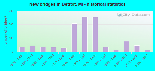
- New bridges - historical statistics
- 1Before 1900
- 371900-1909
- 431910-1919
- 371920-1929
- 331930-1939
- 291940-1949
- 2071950-1959
- 2591960-1969
- 2551970-1979
- 361980-1989
- 131990-1999
- 762000-2009
- 462010-2019
- 132020-2022
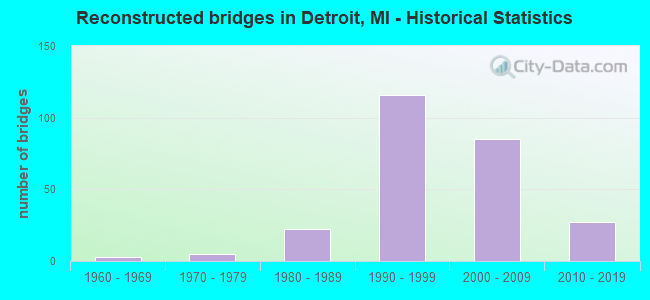
- Reconstructed bridges - Historical Statistics
- 31960-1969
- 51970-1979
- 221980-1989
- 1161990-1999
- 852000-2009
- 272010-2019
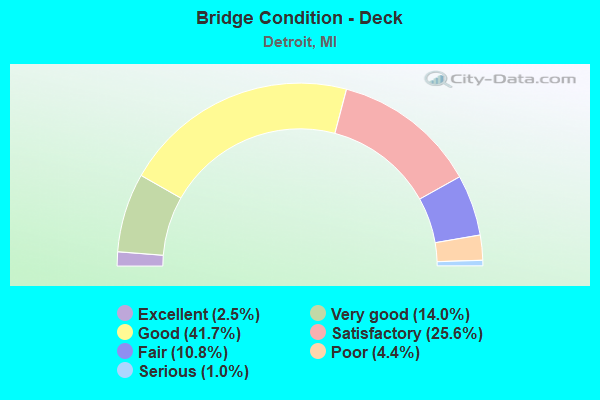
- Bridge Condition - Deck
- 2.5%Excellent
- 14.0%Very good
- 41.7%Good
- 25.6%Satisfactory
- 10.8%Fair
- 4.4%Poor
- 1.0%Serious
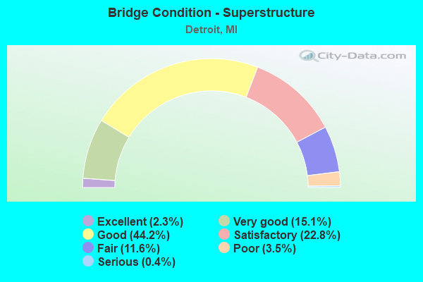
- Bridge Condition - Superstructure
- 2.3%Excellent
- 15.1%Very good
- 44.2%Good
- 22.8%Satisfactory
- 11.6%Fair
- 3.5%Poor
- 0.4%Serious
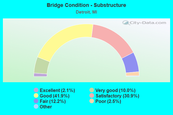
- Bridge Condition - Substructure
- 2.1%Excellent
- 10.0%Very good
- 41.9%Good
- 30.9%Satisfactory
- 12.2%Fair
- 2.5%Poor
- 0.4%Serious
- 0.2%Failed
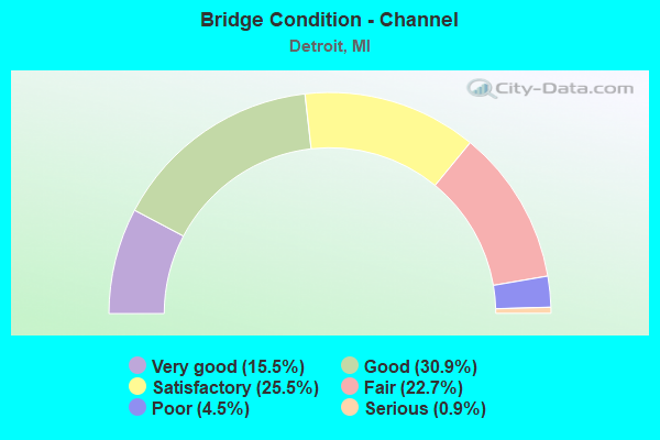
- Bridge Condition - Channel
- 15.5%Very good
- 30.9%Good
- 25.5%Satisfactory
- 22.7%Fair
- 4.5%Poor
- 0.9%Serious
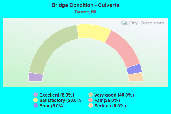
- Bridge Condition - Culverts
- 5.0%Excellent
- 40.0%Very good
- 20.0%Satisfactory
- 25.0%Fair
- 5.0%Poor
- 5.0%Serious
Find on map >> Show street view
Structure Number: 12464, Location: S OF JEFFERSON AVENUE (Lat: 42.324633, Lng: -83.057439), Route carried "under" structure: City street 2000, Year Built: 1984, Structure Length: 0. m, Average Daily Traffic: 8,132 (year 2003), Features Intersected: JEFFERSON AVE, Facility Carried by Structure: SIXTH ST
Minimum Vertical Clearance: 6.60m (21.65ft), Kilometerpoint: 2.932, Lanes on structure: 2, Lanes under structure: 6, Material/Design: Steel, Design/Construction: Stringer/Multi-beam, Length of Maximum Span: 30.7m (100.7ft)
Find on map >> Show street view
Structure Number: 12465, Location: S OF W GRAND BLVD (Lat: 42.358736, Lng: -83.083825), Route carried "under" structure: City street , Year Built: 1916, Structure Length: 0. m, Average Daily Traffic: 420 (year 1977), Features Intersected: COMMONWEALTH, Facility Carried by Structure: CONRAIL
Minimum Vertical Clearance: 3.91m (12.83ft), Kilometerpoint: 0.311, Lanes under structure: 2, Material/Design: Steel, Design/Construction: Stringer/Multi-beam, Length of Maximum Span: 8.5m (27.9ft)
Find on map >> Show street view
Structure Number: 12466, Location: S OF W GRAND BLVD (Lat: 42.358444, Lng: -83.083658), Route carried "under" structure: City street , Year Built: 1916, Structure Length: 0. m, Average Daily Traffic: 420 (year 1977), Features Intersected: COMMONWEALTH, Facility Carried by Structure: GTW RR
Minimum Vertical Clearance: 3.91m (12.83ft), Kilometerpoint: 0.275, Lanes under structure: 2, Material/Design: Steel, Design/Construction: Stringer/Multi-beam, Length of Maximum Span: 8.5m (27.9ft)
Find on map >> Show street view
Structure Number: 12468, Location: S OF FORD FREEWAY (Lat: 42.351139, Lng: -83.089142), Route carried "under" structure: City street , Year Built: 1908, Structure Length: 0. m, Average Daily Traffic: 671 (year 1977), Features Intersected: FIFTEENTH, Facility Carried by Structure: CONRAIL
Minimum Vertical Clearance: 3.88m (12.73ft), Kilometerpoint: 0.361, Lanes under structure: 2, Material/Design: Steel, Design/Construction: Girder and Floorbeam System, Length of Maximum Span: 9.7m (31.8ft)
Find on map >> Show street view
Structure Number: 12469, Location: S OF FORD FREEWAY (Lat: 42.350800, Lng: -83.088950), Route carried "under" structure: City street , Year Built: 1908, Structure Length: 0. m, Average Daily Traffic: 671 (year 1977), Features Intersected: FIFTEENTH, Facility Carried by Structure: GTW RR
Minimum Vertical Clearance: 3.88m (12.73ft), Kilometerpoint: 0.320, Lanes under structure: 2, Material/Design: Steel, Design/Construction: Girder and Floorbeam System, Length of Maximum Span: 9.7m (31.8ft)
Find on map >> Show street view
Structure Number: 12471, Location: S OF W GRAND BLVD (Lat: 42.362639, Lng: -83.080472), Route carried "under" structure: City street , Year Built: 1916, Structure Length: 0. m, Average Daily Traffic: 3,225 (year 1976), Features Intersected: HOLDEN, Facility Carried by Structure: CONRAIL
Minimum Vertical Clearance: 4.03m (13.22ft), Kilometerpoint: 0.105, Lanes under structure: 4, Material/Design: Steel, Design/Construction: Stringer/Multi-beam, Length of Maximum Span: 6.7m (22.0ft)
Find on map >> Show street view
Structure Number: 12472, Location: S OF W GRAND BLVD (Lat: 42.362664, Lng: -83.080678), Route carried "under" structure: City street , Year Built: 1916, Structure Length: 0. m, Average Daily Traffic: 3,225 (year 1976), Features Intersected: HOLDEN, Facility Carried by Structure: CONRAIL
Minimum Vertical Clearance: 4.03m (13.22ft), Kilometerpoint: 0.122, Lanes under structure: 4, Material/Design: Steel, Design/Construction: Stringer/Multi-beam, Length of Maximum Span: 7.0m (23.0ft)
Find on map >> Show street view
Structure Number: 12473, Location: S OF W GRAND BLVD (Lat: 42.362708, Lng: -83.081028), Route carried "under" structure: City street , Year Built: 1916, Structure Length: 0. m, Average Daily Traffic: 3,225 (year 1976), Features Intersected: HOLDEN, Facility Carried by Structure: GTW RR
Minimum Vertical Clearance: 4.03m (13.22ft), Kilometerpoint: 0.151, Lanes under structure: 4, Material/Design: Steel, Design/Construction: Stringer/Multi-beam, Length of Maximum Span: 7.0m (23.0ft)
Find on map >> Show street view
Structure Number: 12476, Location: W OF JOHN R (Lat: 42.436972, Lng: -83.104728), Route carried "under" structure: City street , Year Built: 1938, Structure Length: 0. m, Average Daily Traffic: 2,159 (year 1978), Features Intersected: LANTZ, Facility Carried by Structure: GTW RR
Minimum Vertical Clearance: 4.42m (14.50ft), Kilometerpoint: 1.006, Lanes under structure: 4, Material/Design: Steel, Design/Construction: Girder and Floorbeam System, Length of Maximum Span: 19.8m (65.0ft)
Find on map >> Show street view
Structure Number: 12477, Location: N OF MYRTLE (Lat: 42.336822, Lng: -83.098992), Route carried "under" structure: City street , Year Built: 1933, Structure Length: 0. m, Average Daily Traffic: 345 (year 1978), Features Intersected: MCKINLEY, Facility Carried by Structure: CONRAIL
Minimum Vertical Clearance: 4.21m (13.81ft), Kilometerpoint: 0.341, Lanes under structure: 2, Material/Design: Steel, Design/Construction: Stringer/Multi-beam, Length of Maximum Span: 12.8m (42.0ft)
Find on map >> Show street view
Structure Number: 12478, Location: N OF MYRTLE (Lat: 42.336567, Lng: -83.098819), Route carried "under" structure: City street , Year Built: 1933, Structure Length: 0. m, Average Daily Traffic: 345 (year 1978), Features Intersected: MCKINLEY, Facility Carried by Structure: GTW RR
Minimum Vertical Clearance: 4.21m (13.81ft), Kilometerpoint: 0.309, Lanes under structure: 2, Material/Design: Steel, Design/Construction: Stringer/Multi-beam, Length of Maximum Span: 12.8m (42.0ft)
Find on map >> Show street view
Structure Number: 12479, Location: N OF TOLEDO (Lat: 42.319872, Lng: -83.110200), Route carried "under" structure: City street , Year Built: 1922, Structure Length: 0. m, Average Daily Traffic: 697 (year 1978), Features Intersected: MILITARY, Facility Carried by Structure: NS & CONRAIL RR
Minimum Vertical Clearance: 3.60m (11.81ft), Kilometerpoint: 1.391, Lanes under structure: 2, Material/Design: Steel, Design/Construction: Stringer/Multi-beam, Length of Maximum Span: 6.7m (22.0ft)
Find on map >> Show street view
Structure Number: 1248, Location: S OF JOHN KRONK (Lat: 42.324250, Lng: -83.113836), Route carried "under" structure: City street , Year Built: 1909, Structure Length: 0. m, Average Daily Traffic: 799 (year 1978), Features Intersected: MILITARY, Facility Carried by Structure: CONRAIL
Minimum Vertical Clearance: 3.53m (11.58ft), Kilometerpoint: 0.504, Lanes under structure: 2, Material/Design: Steel, Design/Construction: Stringer/Multi-beam, Length of Maximum Span: 10.0m (32.8ft)
Find on map >> Show street view
Structure Number: 12484, Location: S OF BUCHANAN (Lat: 42.337753, Lng: -83.098350), Route carried "under" structure: City street , Year Built: 1933, Structure Length: 0. m, Average Daily Traffic: 590 (year 1978), Features Intersected: ROOSEVELT, Facility Carried by Structure: CONRAIL
Minimum Vertical Clearance: 4.24m (13.91ft), Kilometerpoint: 0.428, Lanes under structure: 2, Material/Design: Steel, Design/Construction: Stringer/Multi-beam, Length of Maximum Span: 12.8m (42.0ft)
Find on map >> Show street view
Structure Number: 12485, Location: S OF BUCHANAN (Lat: 42.337481, Lng: -83.098172), Route carried "under" structure: City street , Year Built: 1933, Structure Length: 0. m, Average Daily Traffic: 590 (year 1978), Features Intersected: ROOSEVELT, Facility Carried by Structure: GTW RR
Minimum Vertical Clearance: 4.24m (13.91ft), Kilometerpoint: 0.394, Lanes under structure: 2, Material/Design: Steel, Design/Construction: Stringer/Multi-beam, Length of Maximum Span: 12.8m (42.0ft)
Find on map >> Show street view
Structure Number: 12486, Location: S OF FORD FREEWAY (Lat: 42.350206, Lng: -83.089789), Route carried "under" structure: City street , Year Built: 1908, Structure Length: 0. m, Average Daily Traffic: 342 (year 1977), Features Intersected: SIXTEENTH, Facility Carried by Structure: CONRAIL
Minimum Vertical Clearance: 3.81m (12.50ft), Kilometerpoint: 2.052, Lanes under structure: 2, Material/Design: Steel, Design/Construction: Girder and Floorbeam System, Length of Maximum Span: 12.8m (42.0ft)
Find on map >> Show street view
Structure Number: 12487, Location: S OF FORD FREEWAY (Lat: 42.349867, Lng: -83.089597), Route carried "under" structure: City street , Year Built: 1908, Structure Length: 0. m, Average Daily Traffic: 342 (year 1977), Features Intersected: SIXTEENTH, Facility Carried by Structure: GTW RR
Minimum Vertical Clearance: 3.81m (12.50ft), Kilometerpoint: 2.010, Lanes under structure: 2, Material/Design: Steel, Design/Construction: Girder and Floorbeam System, Length of Maximum Span: 12.8m (42.0ft)
Find on map >> Show street view
Structure Number: 12488, Location: S OF BUCHANAN (Lat: 42.338586, Lng: -83.097772), Route carried "under" structure: City street , Year Built: 1932, Structure Length: 0. m, Average Daily Traffic: 416 (year 1978), Features Intersected: TWENTY-FIFTH, Facility Carried by Structure: CONRAIL
Minimum Vertical Clearance: 4.11m (13.48ft), Kilometerpoint: 0.483, Lanes under structure: 2, Material/Design: Steel, Design/Construction: Stringer/Multi-beam, Length of Maximum Span: 12.8m (42.0ft)
Find on map >> Show street view
Structure Number: 12489, Location: S OF BUCHANAN (Lat: 42.338311, Lng: -83.097597), Route carried "under" structure: City street , Year Built: 1932, Structure Length: 0. m, Average Daily Traffic: 416 (year 1978), Features Intersected: TWENTY-FIFTH, Facility Carried by Structure: GTW RR
Minimum Vertical Clearance: 4.11m (13.48ft), Kilometerpoint: 0.449, Lanes under structure: 2, Material/Design: Steel, Design/Construction: Stringer/Multi-beam, Length of Maximum Span: 12.8m (42.0ft)
Find on map >> Show street view
Structure Number: 1249, Location: S OF BUCHANAN (Lat: 42.340528, Lng: -83.096428), Route carried "under" structure: City street , Year Built: 1931, Structure Length: 0. m, Average Daily Traffic: 682 (year 1978), Features Intersected: TWENTY-THIRD, Facility Carried by Structure: CONRAIL
Minimum Vertical Clearance: 4.21m (13.81ft), Kilometerpoint: 0.621, Lanes under structure: 2, Material/Design: Steel, Design/Construction: Stringer/Multi-beam, Length of Maximum Span: 8.2m (26.9ft)
Find on map >> Show street view
Structure Number: 12491, Location: S OF BUCHANAN (Lat: 42.340258, Lng: -83.096250), Route carried "under" structure: City street , Year Built: 1931, Structure Length: 0. m, Average Daily Traffic: 682 (year 1978), Features Intersected: TWENTY-THIRD, Facility Carried by Structure: GTW RR
Minimum Vertical Clearance: 4.21m (13.81ft), Kilometerpoint: 0.587, Lanes under structure: 2, Material/Design: Steel, Design/Construction: Stringer/Multi-beam, Length of Maximum Span: 8.2m (26.9ft)
Find on map >> Show street view
Structure Number: 12712, Location: FORT ST (Lat: 42.283503, Lng: -83.149192), Route carried "under" structure: City street , Year Built: 2010, Structure Length: 0. m, Average Daily Traffic: 2,630 (year 1987), Features Intersected: PLEASANT ST, Facility Carried by Structure: M-85 (FORT ST)
Minimum Vertical Clearance: 5.15m (16.90ft), Kilometerpoint: 0.307, Lanes on structure: 6, Lanes under structure: 2, Material/Design: Prestressed concrete, Design/Construction: Stringer/Multi-beam, Length of Maximum Span: 18.7m (61.4ft)
Find on map >> Show street view
Structure Number: 1281, Location: I-75 & I-375 INTERCHANGE (Lat: 42.342425, Lng: -83.046083), Route carried "under" structure: Ramp Interstate 75, Year Built: 1970, Structure Length: 0. m, Average Daily Traffic: 42,500 (year 1995), Truck Traffic: 15%, Features Intersected: I-75 SB TO EB RAMP, Facility Carried by Structure: BRUSH ST ENTR RMP
Minimum Vertical Clearance: 4.52m (14.83ft), Kilometerpoint: 0.275, Lanes on structure: 1, Lanes under structure: 1, Material/Design: Steel, Design/Construction: Stringer/Multi-beam, Length of Maximum Span: 8.8m (28.9ft)
Find on map >> Show street view
Structure Number: 1318, Location: IN DETROIT (Lat: 42.328111, Lng: -83.086611), Route carried "under" structure: Interstate 75, Year Built: 2005, Structure Length: 0. m, Average Daily Traffic: 57,000 (year 1995), Truck Traffic: 22%, Features Intersected: W BD SERV RD& I-75/I-96, Facility Carried by Structure: CPR - CONRAIL
Minimum Vertical Clearance: 4.44m (14.57ft), Kilometerpoint: 1.674, Lanes under structure: 10, Material/Design: Steel, Design/Construction: Stringer/Multi-beam, Length of Maximum Span: 15.2m (49.9ft)
Find on map >> Show street view
Structure Number: 13312, Location: AMBASSADOR GATEWAY (Lat: 42.320347, Lng: -83.081986), Route carried "under" structure: Interstate 75, Year Built: 2007, Structure Length: 0. m, Average Daily Traffic: 23,050 (year 2015), Truck Traffic: 13%, Features Intersected: I-75 AND I-96
Minimum Vertical Clearance: 4.72m (15.49ft), Kilometerpoint: 9.219, Lanes on structure: 2, Lanes under structure: 4, Material/Design: Steel continuous, Design/Construction: Stringer/Multi-beam, Length of Maximum Span: 53.4m (175.2ft)
Find on map >> Show street view
Structure Number: 13312, Location: AMBASSADOR GATEWAY (Lat: 42.320347, Lng: -83.081986), Route carried "under" structure: Interstate 96, Year Built: 2007, Structure Length: 0. m, Average Daily Traffic: 21,750 (year 2015), Truck Traffic: 13%, Features Intersected: I-75 AND I-96, Facility Carried by Structure: SB I-75 RMP TO TP
Minimum Vertical Clearance: 5.79m (19.00ft), Kilometerpoint: 9.172, Lanes on structure: 2, Lanes under structure: 1, Material/Design: Steel continuous, Design/Construction: Stringer/Multi-beam, Length of Maximum Span: 53.4m (175.2ft)
Find on map >> Show street view
Structure Number: 13312, Location: AMBASSADOR GATEWAY (Lat: 42.320347, Lng: -83.081986), Route carried "under" structure: Interstate 96, Year Built: 2007, Structure Length: 0. m, Average Daily Traffic: 21,750 (year 2015), Truck Traffic: 13%, Features Intersected: I-75 AND I-96, Facility Carried by Structure: SB I-75 RMP TO TP
Minimum Vertical Clearance: 5.79m (19.00ft), Kilometerpoint: 9.219, Lanes on structure: 2, Lanes under structure: 1, Material/Design: Steel continuous, Design/Construction: Stringer/Multi-beam, Length of Maximum Span: 53.4m (175.2ft)
Find on map >> Show street view
Structure Number: 13312, Location: AMBASSADOR GATEWAY (Lat: 42.320347, Lng: -83.081986), Route carried "under" structure: Interstate 75, Year Built: 2007, Structure Length: 0. m, Average Daily Traffic: 37,004 (year 2015), Truck Traffic: 13%, Features Intersected: I-75 AND I-96
Minimum Vertical Clearance: 5.79m (19.00ft), Kilometerpoint: 34.119, Lanes on structure: 2, Lanes under structure: 3, Material/Design: Steel continuous, Design/Construction: Stringer/Multi-beam, Length of Maximum Span: 53.4m (175.2ft)
Find on map >> Show street view
Structure Number: 13313, Location: AMBASSADOR GATEWAY (Lat: 42.321628, Lng: -83.082819), Route carried "under" structure: Interstate 96, Year Built: 2007, Structure Length: 0. m, Average Daily Traffic: 35,000 (year 0000), Features Intersected: EB I-96, Facility Carried by Structure: SB I-75 EXIT RAMP
Minimum Vertical Clearance: 4.67m (15.32ft), Kilometerpoint: 9.074, Lanes on structure: 2, Lanes under structure: 4, Material/Design: Steel continuous, Design/Construction: Stringer/Multi-beam, Length of Maximum Span: 35.8m (117.5ft)
Find on map >> Show street view
Structure Number: 13314, Location: AMBASSADOR GATEWAY (Lat: 42.320828, Lng: -83.082153), Route carried "under" structure: Ramp Interstate 96, Year Built: 2007, Structure Length: 0. m, Average Daily Traffic: 1,030 (year 2013), Features Intersected: I-75 AND WB I-96, Facility Carried by Structure: SB I-75 RMP TO VER
Minimum Vertical Clearance: 4.65m (15.26ft), Kilometerpoint: 0.000, Lanes on structure: 1, Lanes under structure: 1, Material/Design: Steel continuous, Design/Construction: Stringer/Multi-beam, Length of Maximum Span: 38.9m (127.6ft)
Find on map >> Show street view
Structure Number: 13314, Location: AMBASSADOR GATEWAY (Lat: 42.320828, Lng: -83.082153), Route carried "under" structure: Interstate 75, Year Built: 2007, Structure Length: 0. m, Average Daily Traffic: 5,490 (year 2013), Truck Traffic: 9%, Features Intersected: I-75 AND WB I-96
Minimum Vertical Clearance: 4.65m (15.26ft), Kilometerpoint: 34.205, Lanes on structure: 1, Lanes under structure: 7, Material/Design: Steel continuous, Design/Construction: Stringer/Multi-beam, Length of Maximum Span: 38.9m (127.6ft)
Find on map >> Show street view
Structure Number: 13315, Location: AMBASSADOR GATEWAY (Lat: 42.320628, Lng: -83.081594), Route carried "under" structure: Ramp Interstate 75, Year Built: 2007, Structure Length: 0. m, Average Daily Traffic: 3,914 (year 2010), Truck Traffic: 99%, Features Intersected: I-75 AND I-96, Facility Carried by Structure: TRK RMP FRM TP
Minimum Vertical Clearance: 5.08m (16.67ft), Kilometerpoint: 0.404, Lanes on structure: 2, Lanes under structure: 2, Material/Design: Steel continuous, Design/Construction: Stringer/Multi-beam, Length of Maximum Span: 39.6m (129.9ft)
Find on map >> Show street view
Structure Number: 13315, Location: AMBASSADOR GATEWAY (Lat: 42.320628, Lng: -83.081594), Route carried "under" structure: Ramp Interstate 75, Year Built: 2007, Structure Length: 0. m, Average Daily Traffic: 1,390 (year 2013), Truck Traffic: 99%, Features Intersected: I-75 AND I-96, Facility Carried by Structure: TRK RMP FRM TP
Minimum Vertical Clearance: 5.87m (19.26ft), Kilometerpoint: 0.000, Lanes on structure: 2, Lanes under structure: 2, Material/Design: Steel continuous, Design/Construction: Stringer/Multi-beam, Length of Maximum Span: 39.6m (129.9ft)
Find on map >> Show street view
Structure Number: 13315, Location: AMBASSADOR GATEWAY (Lat: 42.320628, Lng: -83.081594), Route carried "under" structure: Ramp Interstate 75, Year Built: 2007, Structure Length: 0. m, Average Daily Traffic: 1,060 (year 2010), Truck Traffic: 99%, Features Intersected: I-75 AND I-96, Facility Carried by Structure: TRK RMP FRM TP
Minimum Vertical Clearance: 4.75m (15.58ft), Kilometerpoint: 0.206, Lanes on structure: 2, Lanes under structure: 1, Material/Design: Steel continuous, Design/Construction: Stringer/Multi-beam, Length of Maximum Span: 39.6m (129.9ft)
Find on map >> Show street view
Structure Number: 13316, Location: AMBASSADOR GATEWAY (Lat: 42.321775, Lng: -83.082183), Route carried "under" structure: Ramp Interstate 75, Year Built: 2007, Structure Length: 0. m, Average Daily Traffic: 1,060 (year 2010), Truck Traffic: 99%, Features Intersected: NB I-75, Facility Carried by Structure: WB -96 RMP FRM TP
Minimum Vertical Clearance: 4.90m (16.08ft), Kilometerpoint: 0.011, Lanes on structure: 1, Lanes under structure: 1, Material/Design: Steel continuous, Design/Construction: Stringer/Multi-beam, Length of Maximum Span: 68.0m (223.1ft)
Find on map >> Show street view
Structure Number: 13316, Location: AMBASSADOR GATEWAY (Lat: 42.321775, Lng: -83.082183), Route carried "under" structure: Interstate 75, Year Built: 2007, Structure Length: 0. m, Average Daily Traffic: 37,004 (year 2015), Truck Traffic: 99%, Features Intersected: NB I-75, Facility Carried by Structure: WB -96 RMP FRM TP
Minimum Vertical Clearance: 4.85m (15.91ft), Kilometerpoint: 34.300, Lanes on structure: 1, Lanes under structure: 3, Material/Design: Steel continuous, Design/Construction: Stringer/Multi-beam, Length of Maximum Span: 68.0m (223.1ft)
Find on map >> Show street view
Structure Number: 13317, Location: AMBASSADOR GATEWAY (Lat: 42.322311, Lng: -83.081717), Route carried "under" structure: Ramp Interstate 75, Year Built: 2007, Structure Length: 0. m, Average Daily Traffic: 2,500 (year 0000), Features Intersected: NB I-75 RMP TO VERNOR
Minimum Vertical Clearance: 9.75m (31.99ft), Kilometerpoint: 0.116, Lanes on structure: 1, Lanes under structure: 1, Material/Design: Steel, Design/Construction: Stringer/Multi-beam, Length of Maximum Span: 35.1m (115.2ft)
Find on map >> Show street view
Structure Number: 13318, Location: AMBASSADOR GATEWAY (Lat: 42.322836, Lng: -83.082700), Route carried "under" structure: Interstate 75, Year Built: 2007, Structure Length: 0. m, Average Daily Traffic: 37,004 (year 2015), Truck Traffic: 40%, Features Intersected: I-75 AND I-96
Minimum Vertical Clearance: 10.52m (34.51ft), Kilometerpoint: 34.414, Lanes on structure: 2, Lanes under structure: 3, Material/Design: Steel continuous, Design/Construction: Stringer/Multi-beam, Length of Maximum Span: 46.8m (153.5ft)
Find on map >> Show street view
Structure Number: 13318, Location: AMBASSADOR GATEWAY (Lat: 42.322836, Lng: -83.082700), Route carried "under" structure: Ramp Interstate 96, Year Built: 2007, Structure Length: 0. m, Average Daily Traffic: 1,390 (year 2015), Truck Traffic: 40%, Features Intersected: I-75 AND I-96, Facility Carried by Structure: RMP TO SB I-75
Minimum Vertical Clearance: 6.76m (22.18ft), Kilometerpoint: 0.233, Lanes on structure: 2, Lanes under structure: 1, Material/Design: Steel continuous, Design/Construction: Stringer/Multi-beam, Length of Maximum Span: 46.8m (153.5ft)
Find on map >> Show street view
Structure Number: 13318, Location: AMBASSADOR GATEWAY (Lat: 42.322836, Lng: -83.082700), Route carried "under" structure: Interstate 96, Year Built: 2007, Structure Length: 0. m, Average Daily Traffic: 21,750 (year 2015), Truck Traffic: 40%, Features Intersected: I-75 AND I-96, Facility Carried by Structure: RMP TO SB I-75
Minimum Vertical Clearance: 10.87m (35.66ft), Kilometerpoint: 8.960, Lanes on structure: 2, Lanes under structure: 2, Material/Design: Steel continuous, Design/Construction: Stringer/Multi-beam, Length of Maximum Span: 46.8m (153.5ft)
Find on map >> Show street view
Structure Number: 13318, Location: AMBASSADOR GATEWAY (Lat: 42.322836, Lng: -83.082700), Route carried "under" structure: Ramp Interstate 75, Year Built: 2007, Structure Length: 0. m, Average Daily Traffic: 640 (year 2015), Truck Traffic: 40%, Features Intersected: I-75 AND I-96
Minimum Vertical Clearance: 8.33m (27.33ft), Kilometerpoint: 0.229, Lanes on structure: 2, Lanes under structure: 2, Material/Design: Steel continuous, Design/Construction: Stringer/Multi-beam, Length of Maximum Span: 46.8m (153.5ft)
Find on map >> Show street view
Structure Number: 13318, Location: AMBASSADOR GATEWAY (Lat: 42.322836, Lng: -83.082700), Route carried "under" structure: Interstate 75, Year Built: 2007, Structure Length: 0. m, Average Daily Traffic: 4,410 (year 2015), Truck Traffic: 40%, Features Intersected: I-75 AND I-96
Minimum Vertical Clearance: 10.69m (35.07ft), Kilometerpoint: 34.628, Lanes on structure: 2, Lanes under structure: 3, Material/Design: Steel continuous, Design/Construction: Stringer/Multi-beam, Length of Maximum Span: 46.8m (153.5ft)
Find on map >> Show street view
Structure Number: 13318, Location: AMBASSADOR GATEWAY (Lat: 42.322836, Lng: -83.082700), Route carried "under" structure: Interstate 96, Year Built: 2007, Structure Length: 0. m, Average Daily Traffic: 21,750 (year 2015), Truck Traffic: 40%, Features Intersected: I-75 AND I-96, Facility Carried by Structure: RMP TO SB I-75
Minimum Vertical Clearance: 10.67m (35.01ft), Kilometerpoint: 8.964, Lanes on structure: 2, Lanes under structure: 1, Material/Design: Steel continuous, Design/Construction: Stringer/Multi-beam, Length of Maximum Span: 46.8m (153.5ft)
Find on map >> Show street view
Structure Number: 13318, Location: AMBASSADOR GATEWAY (Lat: 42.322836, Lng: -83.082700), Route carried "under" structure: Ramp Interstate 96, Year Built: 2007, Structure Length: 0. m, Average Daily Traffic: 5,484 (year 2015), Truck Traffic: 40%, Features Intersected: I-75 AND I-96, Facility Carried by Structure: RMP TO SB I-75
Minimum Vertical Clearance: 4.72m (15.49ft), Kilometerpoint: 0.246, Lanes on structure: 2, Lanes under structure: 1, Material/Design: Steel continuous, Design/Construction: Stringer/Multi-beam, Length of Maximum Span: 46.8m (153.5ft)
Find on map >> Show street view
Structure Number: 13319, Location: AMBASSADOR GATEWAY (Lat: 42.322961, Lng: -83.082125), Route carried "under" structure: Ramp Interstate 75, Year Built: 2007, Structure Length: 0. m, Average Daily Traffic: 8,700 (year 0000), Features Intersected: I-75 NB&SB RMP TO VERNOR
Minimum Vertical Clearance: 6.12m (20.08ft), Kilometerpoint: 0.423, Lanes on structure: 1, Lanes under structure: 1, Material/Design: Steel, Design/Construction: Stringer/Multi-beam, Length of Maximum Span: 39.7m (130.2ft)
Find on map >> Show street view
Structure Number: 13319, Location: AMBASSADOR GATEWAY (Lat: 42.322961, Lng: -83.082125), Route carried "under" structure: Ramp Interstate 75, Year Built: 2007, Structure Length: 0. m, Average Daily Traffic: 8,700 (year 0000), Truck Traffic: 12%, Features Intersected: I-75 NB&SB RMP TO VERNOR
Minimum Vertical Clearance: 6.20m (20.34ft), Kilometerpoint: 0.150, Lanes on structure: 1, Lanes under structure: 1, Material/Design: Steel, Design/Construction: Stringer/Multi-beam, Length of Maximum Span: 39.7m (130.2ft)
Find on map >> Show street view
Structure Number: 1332, Location: AMBASSADOR GATEWAY (Lat: 42.323694, Lng: -83.083833), Route carried "under" structure: Interstate 96, Year Built: 2007, Structure Length: 0. m, Features Intersected: I-75 AND I-96, Facility Carried by Structure: BAGLEY AVE PED
Minimum Vertical Clearance: 30+ m (98+ ft), Kilometerpoint: 0.000, Lanes under structure: 4, Material/Design: Steel continuous, Design/Construction: Stayed Girder, Length of Maximum Span: 84.1m (275.9ft)
Find on map >> Show street view
Structure Number: 1332, Location: AMBASSADOR GATEWAY (Lat: 42.323694, Lng: -83.083833), Route carried "under" structure: Interstate 75, Year Built: 2007, Structure Length: 0. m, Average Daily Traffic: 77,000 (year 2009), Truck Traffic: 24%, Features Intersected: I-75 AND I-96, Facility Carried by Structure: BAGLEY AVE PED
Minimum Vertical Clearance: 30+ m (98+ ft), Kilometerpoint: 34.570, Lanes under structure: 12, Material/Design: Steel continuous, Design/Construction: Stayed Girder, Length of Maximum Span: 84.1m (275.9ft)
Find on map >> Show street view
Structure Number: 134, Location: AMBASSADOR GATEWAY (Lat: 42.322950, Lng: -83.082350), Route carried "under" structure: Ramp Interstate 75, Year Built: 2007, Structure Length: 0. m, Features Intersected: I-75 NB AND VERNOR RAMPS, Facility Carried by Structure: PLAZA TO I-96 WB
Minimum Vertical Clearance: 5.94m (19.49ft), Kilometerpoint: 0.000, Lanes on structure: 2, Lanes under structure: 1, Material/Design: Steel continuous, Design/Construction: Stringer/Multi-beam, Length of Maximum Span: 52.6m (172.6ft)
Find on map >> Show street view
Structure Number: 134, Location: AMBASSADOR GATEWAY (Lat: 42.322950, Lng: -83.082350), Route carried "under" structure: Interstate 75, Year Built: 2007, Structure Length: 0. m, Features Intersected: I-75 NB AND VERNOR RAMPS, Facility Carried by Structure: PLAZA TO I-96 WB
Minimum Vertical Clearance: 4.78m (15.68ft), Kilometerpoint: 0.000, Lanes on structure: 2, Lanes under structure: 3, Material/Design: Steel continuous, Design/Construction: Stringer/Multi-beam, Length of Maximum Span: 52.6m (172.6ft)
Find on map >> Show street view
Structure Number: 134, Location: AMBASSADOR GATEWAY (Lat: 42.322950, Lng: -83.082350), Route carried "under" structure: Ramp Interstate 75, Year Built: 2007, Structure Length: 0. m, Average Daily Traffic: 10 (year 0000), Features Intersected: I-75 NB AND VERNOR RAMPS, Facility Carried by Structure: PLAZA TO I-96 WB
Minimum Vertical Clearance: 6.10m (20.01ft), Kilometerpoint: 34.433, Lanes on structure: 2, Lanes under structure: 1, Material/Design: Steel continuous, Design/Construction: Stringer/Multi-beam, Length of Maximum Span: 52.6m (172.6ft)
Find on map >> Show street view
Structure Number: 13403, Location: AMBASSADOR GATEWAY (Lat: 42.322583, Lng: -83.081528), Route carried "under" structure: Ramp Interstate 75, Year Built: 2007, Structure Length: 0. m, Average Daily Traffic: 862 (year 2010), Features Intersected: NB&SB RMPS TO VERNOR
Minimum Vertical Clearance: 9.73m (31.92ft), Kilometerpoint: 0.116, Lanes on structure: 1, Lanes under structure: 1, Material/Design: Steel continuous, Design/Construction: Stringer/Multi-beam, Length of Maximum Span: 60.2m (197.5ft)
Find on map >> Show street view
Structure Number: 13403, Location: AMBASSADOR GATEWAY (Lat: 42.322583, Lng: -83.081528), Route carried "under" structure: Ramp Interstate 75, Year Built: 2007, Structure Length: 0. m, Average Daily Traffic: 1,060 (year 2010), Truck Traffic: 40%, Features Intersected: NB&SB RMPS TO VERNOR
Minimum Vertical Clearance: 8.56m (28.08ft), Kilometerpoint: 0.407, Lanes on structure: 1, Lanes under structure: 2, Material/Design: Steel continuous, Design/Construction: Stringer/Multi-beam, Length of Maximum Span: 60.2m (197.5ft)
Find on map >> Show street view
Structure Number: 13499, Location: IN DETROIT (Lat: 42.397731, Lng: -83.109147), Route carried "under" structure: Ramp State highway 8, Year Built: 1956, Structure Length: 0. m, Average Daily Traffic: 30,000 (year 2007), Truck Traffic: 2%, Features Intersected: M-8 RAMP TO M-10 SB, Facility Carried by Structure: M-10 WB
Minimum Vertical Clearance: 4.44m (14.57ft), Kilometerpoint: 0.344, Lanes on structure: 4, Lanes under structure: 1, Material/Design: Steel, Design/Construction: Stringer/Multi-beam, Length of Maximum Span: 21.0m (68.9ft)
Find on map >> Show street view
Structure Number: 13531, Location: S OF MICHIGAN AVE (Lat: 42.325567, Lng: -83.107419), Route carried "under" structure: City street , Year Built: 2015, Structure Length: 0. m, Average Daily Traffic: 100 (year 2015), Features Intersected: JUNCTION AVE, Facility Carried by Structure: CN RR
Minimum Vertical Clearance: 4.55m (14.93ft), Kilometerpoint: 2.718, Lanes under structure: 2, Material/Design: Steel, Design/Construction: Girder and Floorbeam System, Length of Maximum Span: 22.1m (72.5ft)
Find on map >> Show street view
Structure Number: 14043, Location: IN DETROIT (Lat: 42.343353, Lng: -83.068100), Route carried "under" structure: State highway 10, Year Built: 2017, Structure Length: 0. m, Average Daily Traffic: 98,775 (year 2018), Truck Traffic: 2%, Features Intersected: M-10, Facility Carried by Structure: MLK JR BLVD WB
Minimum Vertical Clearance: 4.57m (14.99ft), Kilometerpoint: 17.222, Lanes on structure: 2, Lanes under structure: 7, Material/Design: Prestressed concrete, Design/Construction: Box Beam or Girders - Single/Spread, Length of Maximum Span: 22.7m (74.5ft)