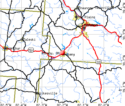
Albany, Ohio
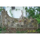
Albany: This wall is well preserved considering it is over 100 yrs old
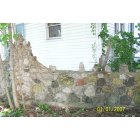
Albany: This wall is well preserved considering it was built back in the 1900's .
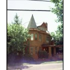
Albany: This house was built around 1930's .
- add
your
Submit your own pictures of this village and show them to the world
- OSM Map
- General Map
- Google Map
- MSN Map
Population change since 2000: +14.2%
 |
| Males: 400 | |
| Females: 523 |
| Median resident age: | 41.0 years |
| Ohio median age: | 39.9 years |
Zip codes: 45710.
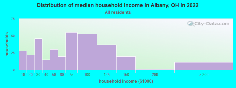
| Albany: | $59,959 |
| OH: | $65,720 |
Estimated per capita income in 2022: $28,833 (it was $16,047 in 2000)
Albany village income, earnings, and wages data
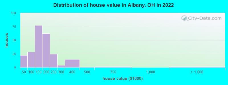
Estimated median house or condo value in 2022: $156,332 (it was $82,900 in 2000)
| Albany: | $156,332 |
| OH: | $204,100 |
Mean prices in 2022: all housing units: $209,967; detached houses: $236,762; townhouses or other attached units: $213,350; in 2-unit structures: $158,855; in 3-to-4-unit structures: $237,016; in 5-or-more-unit structures: $168,090; mobile homes: $66,969
Median gross rent in 2022: $860.
Detailed information about poverty and poor residents in Albany, OH

Compare current foreclosures near Albany, OH:
| Photo | Address | Area | Beds / Baths | Price | Details |
|---|---|---|---|---|---|

|
#1
Laurel Rd
Albany, OH 45710
|
1,836 sq. feet
|
2 baths 3 beds |
show details | |

|
#2
Swart Rd
Albany, OH 45710
|
1,056 sq. feet
|
1 baths 3 beds |
show details | |

|
#3
Raymar Dr
Albany, OH 45710
|
1,264 sq. feet
|
2 baths 3 beds |
show details | |

|
#4
Raymar Dr
Albany, OH 45710
|
1,264 sq. feet
|
2 baths 3 beds |
show details | |

|
#5
Raymar Dr
Albany, OH 45710
|
1,264 sq. feet
|
2 baths 3 beds |
show details | |

|
#6
State Route 689
Albany, OH 45710
|
- sq. feet
|
- baths - beds |
show details | |

|
#7
Raymar Dr
Albany, OH 45710
|
- sq. feet
|
- baths - beds |
show details | |

|
#8
Gaston Rd
Albany, OH 45710
|
- sq. feet
|
- baths - beds |
show details | |

|
#9
Setty Rd
Albany, OH 45710
|
- sq. feet
|
- baths - beds |
show details | |

|
#10
State Route 328
New Plymouth, OH 45654
|
1,724 sq. feet
|
1 baths 2 beds |
show details |
| Photo | Address | Area | Beds / Baths | Price | Details |
|---|---|---|---|---|---|

|
#11
Grosvenor St
Athens, OH 45701
|
1,872 sq. feet
|
1 baths 3 beds |
show details | |

|
#12
Walnut St
Nelsonville, OH 45764
|
1,078 sq. feet
|
1 baths 1 beds |
show details | |

|
#13
W Washington St
Nelsonville, OH 45764
|
1,362 sq. feet
|
1 baths 2 beds |
show details | |

|
#14
Avon Pl
Athens, OH 45701
|
941 sq. feet
|
1 baths 3 beds |
show details | |

|
#15
Hysell Run Rd
Pomeroy, OH 45769
|
- sq. feet
|
- baths - beds |
show details | |

|
#16
State Route 93
Hamden, OH 45634
|
- sq. feet
|
- baths - beds |
show details | |

|
#17
Main Street & 0 Main Str
Millfield, OH 45761
|
- sq. feet
|
- baths - beds |
show details | |

|
#18
Pine Grove Dr
Nelsonville, OH 45764
|
- sq. feet
|
- baths - beds |
show details | |

|
#19
E Canal St
Nelsonville, OH 45764
|
- sq. feet
|
- baths - beds |
show details | |

|
#20
W Washington St
Nelsonville, OH 45764
|
- sq. feet
|
- baths - beds |
show details |
| Photo | Address | Area | Beds / Baths | Price | Details |
|---|---|---|---|---|---|

|
#21
May St
Chauncey, OH 45719
|
- sq. feet
|
- baths - beds |
show details | |

|
#22
Grover St
Nelsonville, OH 45764
|
- sq. feet
|
- baths - beds |
show details | |

|
#23
Monserat Ridge Rd
Millfield, OH 45761
|
- sq. feet
|
- baths - beds |
show details | |

|
#24
Truetown Rd
Millfield, OH 45761
|
- sq. feet
|
- baths - beds |
show details | |

|
#25
Minerton Rd
Vinton, OH 45686
|
- sq. feet
|
- baths - beds |
show details | |

|
#26
Price Strong Rd
Vinton, OH 45686
|
- sq. feet
|
- baths - beds |
show details | |

|
#27
Ackley Rd
Guysville, OH 45735
|
- sq. feet
|
- baths - beds |
show details | |

|
#28
Peterson Hollow Rd
Rutland, OH 45775
|
- sq. feet
|
- baths - beds |
show details | |

|
#29
Bassett Rd
Athens, OH 45701
|
- sq. feet
|
- baths - beds |
show details | |

|
#30
Warren Dr
Nelsonville, OH 45764
|
- sq. feet
|
- baths - beds |
show details |
| Photo | Address | Area | Beds / Baths | Price | Details |
|---|---|---|---|---|---|

|
#31
State Route 550
Athens, OH 45701
|
- sq. feet
|
- baths - beds |
show details | |

|
#32
Baker Rd
Athens, OH 45701
|
- sq. feet
|
- baths - beds |
show details | |

|
#33
State Route 550
Millfield, OH 45761
|
- sq. feet
|
- baths - beds |
show details | |

|
#34
Mound St
The Plains, OH 45780
|
- sq. feet
|
- baths - beds |
show details | |

|
#35
Loop Rd
Rutland, OH 45775
|
1,344 sq. feet
|
- baths - beds |
show details | |

|
#36
Walnut Ct
Athens, OH 45701
|
- sq. feet
|
- baths - beds |
show details | |

|
#37
Selby Rd Lot 65
Athens, OH 45701
|
- sq. feet
|
- baths - beds |
show details | |

|
#38
Brown Ave
Athens, OH 45701
|
- sq. feet
|
- baths - beds |
show details | |

|
#39
Old State Route 56
New Marshfield, OH 45766
|
- sq. feet
|
- baths - beds |
show details | |

|
#40
Old State Rd
Mc Arthur, OH 45651
|
- sq. feet
|
- baths - beds |
show details |
| Photo | Address | Area | Beds / Baths | Price | Details |
|---|---|---|---|---|---|

|
#41
Heatherstone Dr Lot 15
Athens, OH 45701
|
- sq. feet
|
- baths - beds |
show details | |

|
#42
Gibbs Rd
Shade, OH 45776
|
- sq. feet
|
- baths - beds |
show details | |

|
#43
Two Mile Rd
New Plymouth, OH 45654
|
- sq. feet
|
- baths - beds |
show details | |

|
#44
Vinton Station Rd
Hamden, OH 45634
|
- sq. feet
|
- baths - beds |
show details | |

|
#45
Upper River Rd
Athens, OH 45701
|
- sq. feet
|
- baths - beds |
show details | |

|
Check over 1 million property listings on Foreclosure.com!
|
browse all offers | |||


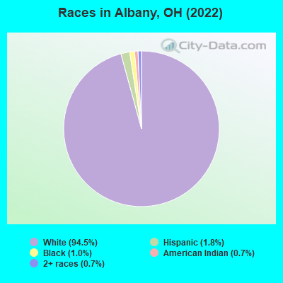
- 79694.5%White alone
- 151.8%Hispanic
- 81.0%Black alone
- 60.7%American Indian alone
- 60.7%Two or more races
Races in Albany detailed stats: ancestries, foreign born residents, place of birth
According to our research of Ohio and other state lists, there were 6 registered sex offenders living in Albany, Ohio as of April 28, 2024.
The ratio of all residents to sex offenders in Albany is 169 to 1.
Type |
2009 |
2010 |
2011 |
2012 |
2013 |
2014 |
2015 |
2016 |
2017 |
2018 |
2019 |
2020 |
2022 |
|---|---|---|---|---|---|---|---|---|---|---|---|---|---|
| Murders (per 100,000) | 0 (0.0) | 0 (0.0) | 0 (0.0) | 0 (0.0) | 0 (0.0) | 0 (0.0) | 0 (0.0) | 0 (0.0) | 0 (0.0) | 0 (0.0) | 0 (0.0) | 0 (0.0) | 0 (0.0) |
| Rapes (per 100,000) | 0 (0.0) | 0 (0.0) | 0 (0.0) | 0 (0.0) | 0 (0.0) | 0 (0.0) | 0 (0.0) | 0 (0.0) | 0 (0.0) | 0 (0.0) | 0 (0.0) | 0 (0.0) | 0 (0.0) |
| Robberies (per 100,000) | 0 (0.0) | 0 (0.0) | 1 (120.6) | 0 (0.0) | 0 (0.0) | 0 (0.0) | 0 (0.0) | 0 (0.0) | 0 (0.0) | 0 (0.0) | 0 (0.0) | 0 (0.0) | 0 (0.0) |
| Assaults (per 100,000) | 0 (0.0) | 0 (0.0) | 0 (0.0) | 0 (0.0) | 0 (0.0) | 1 (112.5) | 0 (0.0) | 0 (0.0) | 0 (0.0) | 0 (0.0) | 0 (0.0) | 0 (0.0) | 0 (0.0) |
| Burglaries (per 100,000) | 10 (1,198) | 1 (120.8) | 2 (241.3) | 1 (120.6) | 3 (342.1) | 1 (112.5) | 32 (3,520) | 6 (653.6) | 1 (111.2) | 2 (218.3) | 3 (330.4) | 0 (0.0) | 1 (110.5) |
| Thefts (per 100,000) | 1 (119.8) | 10 (1,208) | 4 (482.5) | 6 (723.8) | 19 (2,166) | 15 (1,687) | 10 (1,100) | 13 (1,416) | 10 (1,112) | 10 (1,092) | 8 (881.1) | 2 (223.2) | 6 (663.0) |
| Auto thefts (per 100,000) | 0 (0.0) | 0 (0.0) | 0 (0.0) | 0 (0.0) | 0 (0.0) | 0 (0.0) | 0 (0.0) | 1 (108.9) | 0 (0.0) | 0 (0.0) | 0 (0.0) | 0 (0.0) | 0 (0.0) |
| Arson (per 100,000) | 0 (0.0) | 0 (0.0) | 0 (0.0) | 0 (0.0) | 0 (0.0) | 0 (0.0) | 0 (0.0) | 0 (0.0) | 0 (0.0) | 0 (0.0) | 0 (0.0) | 0 (0.0) | 0 (0.0) |
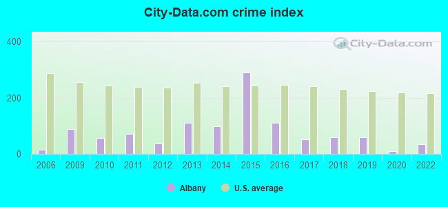
| City-Data.com crime index | 88.6 | 56.8 | 72.4 | 37.4 | 110.6 | 97.9 | 290.4 | 111.1 | 52.3 | 59.0 | 58.4 | 8.9 | 34.3 |
The City-Data.com crime index weighs serious crimes and violent crimes more heavily. Higher means more crime, U.S. average is 246.1. It adjusts for the number of visitors and daily workers commuting into cities.
Crime rate in Albany detailed stats: murders, rapes, robberies, assaults, burglaries, thefts, arson
 Recent articles from our blog. Our writers, many of them Ph.D. graduates or candidates, create easy-to-read articles on a wide variety of topics.

 | Westerville-New Albany 605 Corridor (7 replies) |
| High Schools Gahanna/Blacklick/New Albany (4 replies) |
| Intel picks Ohio for semiconductor project (128 replies) |
| New Albany or Westerville? (9 replies) |
| Westerville and New Albany (6 replies) |
| Looking apartments with indian community near 6595 New Albany Rd E, New Albany, OH 43054 (1 reply) |
Latest news from Albany, OH collected exclusively by city-data.com from local newspapers, TV, and radio stations
Ancestries: Irish (26.6%), German (13.1%), American (11.1%), English (9.4%), Polish (2.9%), Slovak (2.0%).
Current Local Time: EST time zone
Elevation: 755 feet
Land area: 1.24 square miles.
Population density: 742 people per square mile (low).
4 residents are foreign born
| This village: | 0.5% |
| Ohio: | 4.9% |
Median real estate property taxes paid for housing units with mortgages in 2022: $1,819 (1.1%)
Median real estate property taxes paid for housing units with no mortgage in 2022: $1,802 (1.3%)
Nearest city with pop. 50,000+: Huntington, WV  (57.8 miles , pop. 51,475).
Nearest city with pop. 200,000+: Columbus, OH (67.4 miles , pop. 711,470).
Nearest city with pop. 1,000,000+: Chicago, IL (339.9 miles , pop. 2,896,016).
Nearest cities:
), ), ), Latitude: 39.23 N, Longitude: 82.20 W
Area code: 740
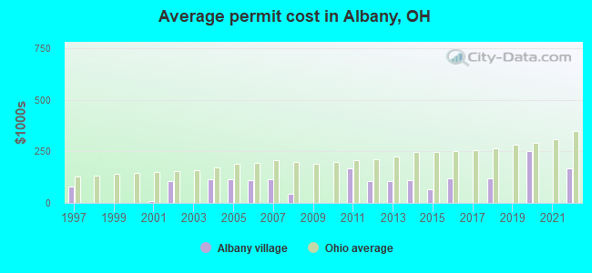
Single-family new house construction building permits:
- 2022: 3 buildings, average cost: $166,700
- 2020: 2 buildings, average cost: $252,500
- 2018: 1 building, cost: $120,000
- 2016: 1 building, cost: $120,000
- 2015: 3 buildings, average cost: $67,300
- 2014: 2 buildings, average cost: $111,000
- 2013: 1 building, cost: $105,000
- 2012: 2 buildings, average cost: $105,000
- 2011: 2 buildings, average cost: $167,300
- 2008: 2 buildings, average cost: $42,500
- 2007: 3 buildings, average cost: $113,300
- 2006: 6 buildings, average cost: $110,200
- 2005: 2 buildings, average cost: $115,000
- 2004: 2 buildings, average cost: $115,000
- 2002: 2 buildings, average cost: $105,000
- 2001: 4 buildings, average cost: $10,100
- 1997: 5 buildings, average cost: $80,000

| Here: | 4.1% |
| Ohio: | 3.1% |
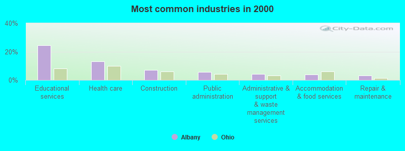
- Educational services (24.5%)
- Health care (13.2%)
- Construction (7.2%)
- Public administration (5.8%)
- Administrative & support & waste management services (4.2%)
- Accommodation & food services (4.0%)
- Repair & maintenance (3.2%)
- Educational services (18.8%)
- Construction (14.4%)
- Public administration (7.9%)
- Administrative & support & waste management services (6.4%)
- Repair & maintenance (6.4%)
- Accommodation & food services (4.5%)
- Mining, quarrying, oil & gas extraction (4.0%)
- Educational services (30.3%)
- Health care (24.2%)
- Social assistance (5.1%)
- Public administration (3.5%)
- Accommodation & food services (3.5%)
- Finance & insurance (3.0%)
- Religious, grantmaking, civic, professional, similar organizations (2.5%)
- Preschool, kindergarten, elementary, and middle school teachers (6.8%)
- Health technologists and technicians (6.5%)
- Building and grounds cleaning and maintenance occupations (5.8%)
- Secretaries and administrative assistants (5.5%)
- Other production occupations, including supervisors (4.0%)
- Electrical equipment mechanics and other installation, maintenance, and repair workers, including supervisors (4.0%)
- Other sales and related occupations, including supervisors (3.8%)
- Electrical equipment mechanics and other installation, maintenance, and repair workers, including supervisors (7.9%)
- Building and grounds cleaning and maintenance occupations (7.4%)
- Other sales and related occupations, including supervisors (5.4%)
- Carpenters (5.4%)
- Vehicle and mobile equipment mechanics, installers, and repairers (5.4%)
- Other food preparation and serving workers, including supervisors (5.0%)
- Construction traders workers except carpenters, electricians, painters, plumbers, and construction laborers (4.5%)

- Preschool, kindergarten, elementary, and middle school teachers (12.6%)
- Secretaries and administrative assistants (11.1%)
- Health technologists and technicians (9.6%)
- Customer service representatives (5.6%)
- Other office and administrative support workers, including supervisors (5.6%)
- Counselors, social workers, and other community and social service specialists (4.5%)
- Cooks and food preparation workers (4.5%)
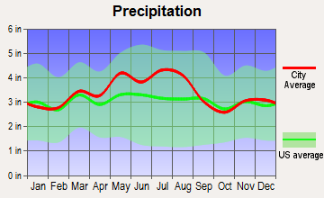
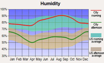
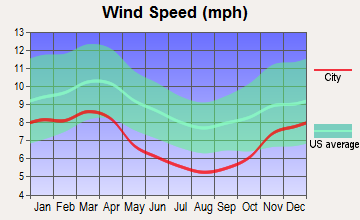
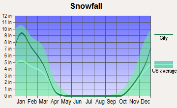
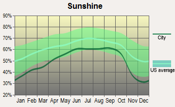
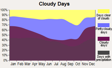
Average climate in Albany, Ohio
Based on data reported by over 4,000 weather stations

(lower is better)
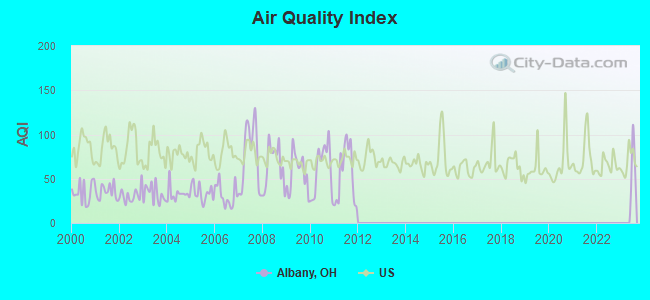
Air Quality Index (AQI) level in 2011 was 55.0. This is better than average.
| City: | 55.0 |
| U.S.: | 72.6 |
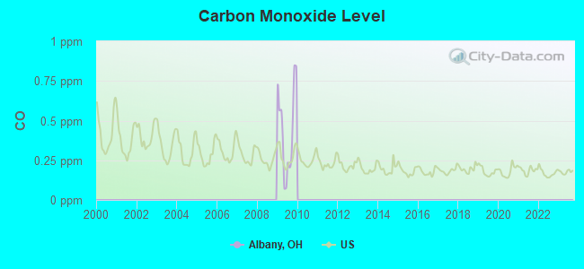
Carbon Monoxide (CO) [ppm] level in 2009 was 0.442. This is significantly worse than average. Closest monitor was 7.0 miles away from the city center.
| City: | 0.442 |
| U.S.: | 0.251 |
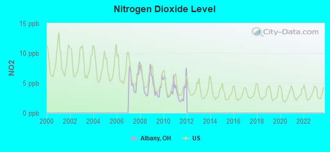
Nitrogen Dioxide (NO2) [ppb] level in 2011 was 3.36. This is significantly better than average. Closest monitor was 7.0 miles away from the city center.
| City: | 3.36 |
| U.S.: | 5.11 |
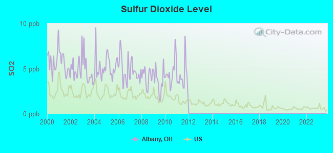
Sulfur Dioxide (SO2) [ppb] level in 2011 was 4.00. This is significantly worse than average. Closest monitor was 7.0 miles away from the city center.
| City: | 4.00 |
| U.S.: | 1.51 |
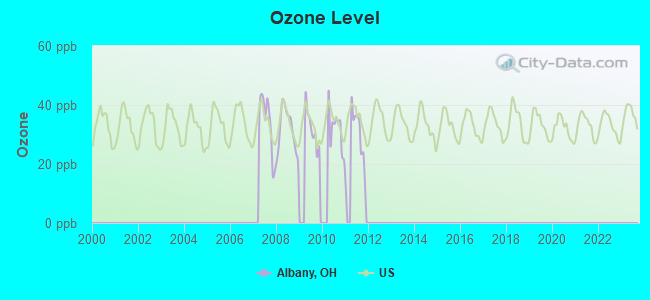
Ozone [ppb] level in 2011 was 28.5. This is about average. Closest monitor was 7.0 miles away from the city center.
| City: | 28.5 |
| U.S.: | 33.3 |
Tornado activity:
Albany-area historical tornado activity is significantly below Ohio state average. It is 40% smaller than the overall U.S. average.
On 4/23/1968, a category F5 (max. wind speeds 261-318 mph) tornado 28.3 miles away from the Albany village center killed 7 people and injured 93 people and caused between $500,000 and $5,000,000 in damages.
On 4/23/1968, a category F4 (max. wind speeds 207-260 mph) tornado 45.6 miles away from the village center killed 6 people and injured 364 people and caused between $5,000,000 and $50,000,000 in damages.
Earthquake activity:
Albany-area historical earthquake activity is significantly above Ohio state average. It is 7% smaller than the overall U.S. average.On 7/27/1980 at 18:52:21, a magnitude 5.2 (5.1 MB, 4.7 MS, 5.0 UK, 5.2 UK, Class: Moderate, Intensity: VI - VII) earthquake occurred 117.7 miles away from the city center
On 8/23/2011 at 17:51:04, a magnitude 5.8 (5.8 MW, Depth: 3.7 mi) earthquake occurred 248.0 miles away from Albany center
On 9/25/1998 at 19:52:52, a magnitude 5.2 (4.8 MB, 4.3 MS, 5.2 LG, 4.5 MW, Depth: 3.1 mi) earthquake occurred 183.1 miles away from the city center
On 1/31/1986 at 16:46:43, a magnitude 5.0 (5.0 MB) earthquake occurred 173.0 miles away from the city center
On 8/9/2020 at 12:07:37, a magnitude 5.1 (5.1 MW, Depth: 4.7 mi) earthquake occurred 199.8 miles away from Albany center
On 9/7/1988 at 02:28:09, a magnitude 4.6 (4.5 MB, 4.6 LG, Class: Light, Intensity: IV - V) earthquake occurred 117.7 miles away from the city center
Magnitude types: regional Lg-wave magnitude (LG), body-wave magnitude (MB), surface-wave magnitude (MS), moment magnitude (MW)
Natural disasters:
The number of natural disasters in Athens County (16) is near the US average (15).Major Disasters (Presidential) Declared: 10
Emergencies Declared: 3
Causes of natural disasters: Floods: 10, Storms: 10, Landslides: 3, Mudslides: 3, Snowstorms: 2, Tornadoes: 2, Blizzard: 1, Heavy Rain: 1, Hurricane: 1, Wind: 1, Winter Storm: 1, Other: 1 (Note: some incidents may be assigned to more than one category).

Hospitals and medical centers in Albany:
Other hospitals and medical centers near Albany:
- KIMES NURSING AND REHAB CTR (Nursing Home, about 7 miles away; ATHENS, OH)
- ATHENS CAMPUS (Hospital, about 9 miles away; ATHENS, OH)
- O'BLENESS MEMORIAL HOSPITAL Acute Care Hospitals (about 9 miles away; ATHENS, OH)
- ECHOING MEADOWS RESIDENTIAL CENTER (Hospital, about 9 miles away; ATHENS, OH)
- HICKORY CREEK OF ATHENS (Nursing Home, about 11 miles away; THE PLAINS, OH)
- RIVERS EDGE DIALYSIS (Dialysis Facility, about 11 miles away; ATHENS, OH)
- FMC - EAST STATE STREET (Dialysis Facility, about 11 miles away; ATHENS, OH)
Airports and heliports located in Albany:
- Ohio University Airport (UNI) (Runways: 1, Air Taxi Ops: 200, Itinerant Ops: 10,222, Local Ops: 42,112, Military Ops: 200)
- Meigs Mine 1 Heliport (5OH5)
- Meigs Mine 2 Heliport (7OH4)
Colleges/universities with over 2000 students nearest to Albany:
- Ohio University-Main Campus (about 9 miles; Athens, OH; Full-time enrollment: 26,181)
- Hocking College (about 15 miles; Nelsonville, OH; FT enrollment: 4,146)
- West Virginia University at Parkersburg (about 38 miles; Parkersburg, WV; FT enrollment: 2,619)
- Ohio Christian University (about 47 miles; Circleville, OH; FT enrollment: 2,345)
- Zane State College (about 52 miles; Zanesville, OH; FT enrollment: 2,200)
- Shawnee State University (about 55 miles; Portsmouth, OH; FT enrollment: 4,160)
- Marshall University (about 58 miles; Huntington, WV; FT enrollment: 11,450)
Public high school in Albany:
Public elementary/middle school in Albany:
- ALEXANDER ELEMENTARY SCHOOL (Students: 784, Location: 6105 SCHOOL ROAD, Grades: PK-6)
Points of interest:
Notable locations in Albany: Southeast Ohio Emergency Medical Services Station 5 Albany (A), Albany Area Volunteer Fire Department (B). Display/hide their locations on the map
Church in Albany: Albany Baptist Church (A). Display/hide its location on the map
Hotel: Carpenter Inn & Conference Center (39655 Carpenter Dyesville).
Drinking water stations with addresses in Albany that have no violations reported:
- ALBANY VILLAGE PWS (Population served: 828, Primary Water Source Type: Purch groundwater)
| This village: | 2.3 people |
| Ohio: | 2.4 people |
| This village: | 66.3% |
| Whole state: | 65.0% |
| This village: | 7.5% |
| Whole state: | 6.8% |
Likely homosexual households (counted as self-reported same-sex unmarried-partner households)
- Lesbian couples: 0.9% of all households
- Gay men: 0.0% of all households
23 people in nursing homes in 2000
Banks with branches in Albany (2011 data):
- The Hocking Valley Bank: Albany Branch at Washington And Clinton Streets, branch established on 1969/07/09. Info updated 2006/11/03: Bank assets: $235.9 mil, Deposits: $208.8 mil, headquarters in Athens, OH, positive income, Commercial Lending Specialization, 7 total offices, Holding Company: Hocking Valley Bancshares, Inc.
For population 15 years and over in Albany:
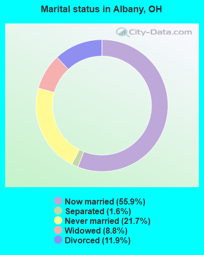
- Never married: 21.7%
- Now married: 55.9%
- Separated: 1.6%
- Widowed: 8.8%
- Divorced: 11.9%
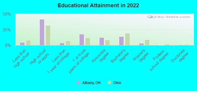
For population 25 years and over in Albany:
- High school or higher: 94.6%
- Bachelor's degree or higher: 18.2%
- Graduate or professional degree: 4.7%
- Unemployed: 4.5%
- Mean travel time to work (commute): 23.4 minutes
| Here: | 8.7 |
| Ohio average: | 11.0 |
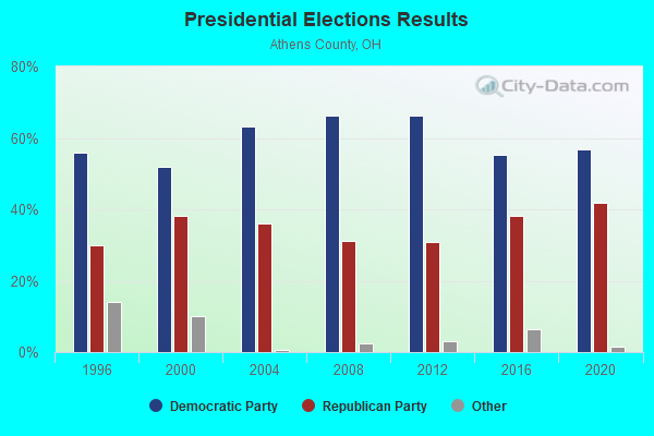
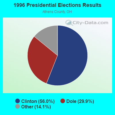
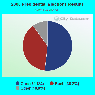
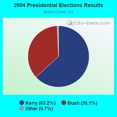
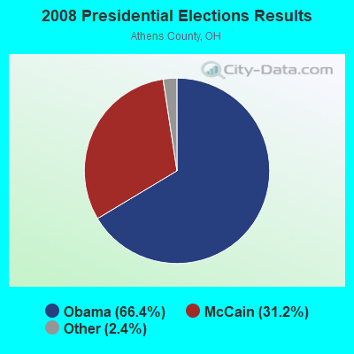
Graphs represent county-level data. Detailed 2008 Election Results
Religion statistics for Albany, OH (based on Athens County data)
| Religion | Adherents | Congregations |
|---|---|---|
| Mainline Protestant | 5,174 | 42 |
| Evangelical Protestant | 5,093 | 45 |
| Catholic | 1,946 | 5 |
| Other | 890 | 5 |
| None | 51,654 | - |
Food Environment Statistics:
| Athens County: | 2.06 / 10,000 pop. |
| Ohio: | 1.89 / 10,000 pop. |
| This county: | 0.16 / 10,000 pop. |
| State: | 0.13 / 10,000 pop. |
| Athens County: | 1.27 / 10,000 pop. |
| Ohio: | 1.25 / 10,000 pop. |
| Athens County: | 3.01 / 10,000 pop. |
| State: | 2.93 / 10,000 pop. |
| Here: | 5.54 / 10,000 pop. |
| State: | 6.25 / 10,000 pop. |
| This county: | 8.3% |
| Ohio: | 10.3% |
| Athens County: | 29.4% |
| Ohio: | 29.1% |
| This county: | 13.9% |
| State: | 11.9% |
Health and Nutrition:
| Here: | 62.7% |
| Ohio: | 50.4% |
| This city: | 66.7% |
| State: | 47.8% |
| This city: | 27.0 |
| Ohio: | 28.7 |
| Albany: | 15.6% |
| Ohio: | 20.6% |
| Albany: | 5.1% |
| State: | 10.4% |
| Albany: | 7.1 |
| Ohio: | 6.8 |
| Albany: | 31.9% |
| Ohio: | 34.3% |
| This city: | 69.6% |
| Ohio: | 57.0% |
| This city: | 83.7% |
| Ohio: | 79.1% |
More about Health and Nutrition of Albany, OH Residents
| Local government employment and payroll (March 2022) | |||||
| Function | Full-time employees | Monthly full-time payroll | Average yearly full-time wage | Part-time employees | Monthly part-time payroll |
|---|---|---|---|---|---|
| Financial Administration | 1 | $2,092 | $25,104 | 0 | $0 |
| Other and Unallocable | 1 | $5,660 | $67,920 | 0 | $0 |
| Police Protection - Officers | 0 | $0 | 1 | $1,960 | |
| Other Government Administration | 0 | $0 | 9 | $6,672 | |
| Totals for Government | 2 | $7,752 | $46,512 | 10 | $8,632 |
Albany government finances - Expenditure in 2017 (per resident):
- Current Operations - Sewerage: $262,000 ($283.86)
Water Utilities: $204,000 ($221.02)
Judicial and Legal Services: $91,000 ($98.59)
Police Protection: $60,000 ($65.01)
Regular Highways: $43,000 ($46.59)
Central Staff Services: $33,000 ($35.75)
Financial Administration: $25,000 ($27.09)
Local Fire Protection: $21,000 ($22.75)
General Public Buildings: $7,000 ($7.58)
Parks and Recreation: $2,000 ($2.17)
- Total Salaries and Wages: $126,000 ($136.51)
- Water Utilities - Interest on Debt: $232,000 ($251.35)
Albany government finances - Revenue in 2017 (per resident):
- Charges - Sewerage: $543,000 ($588.30)
- Miscellaneous - Fines and Forfeits: $40,000 ($43.34)
Rents: $13,000 ($14.08)
General Revenue - Other: $9,000 ($9.75)
Sale of Property: $2,000 ($2.17)
Interest Earnings: $2,000 ($2.17)
Donations From Private Sources: $1,000 ($1.08)
- Revenue - Water Utilities: $301,000 ($326.11)
- State Intergovernmental - Highways: $49,000 ($53.09)
General Local Government Support: $33,000 ($35.75)
- Tax - Property: $108,000 ($117.01)
Motor Vehicle License: $3,000 ($3.25)
Albany government finances - Debt in 2017 (per resident):
- Long Term Debt - Beginning Outstanding - Unspecified Public Purpose: $5,785,000 ($6267.61)
Outstanding Unspecified Public Purpose: $5,634,000 ($6104.01)
Retired Unspecified Public Purpose: $151,000 ($163.60)
Albany government finances - Cash and Securities in 2017 (per resident):
- Other Funds - Cash and Securities: $1,238,000 ($1341.28)
Businesses in Albany, OH
- 7-Eleven: 1
- U-Haul: 1
Strongest AM radio stations in Albany:
- WTVN (610 AM; 50 kW; COLUMBUS, OH; Owner: CITICASTERS LICENSES, L.P.)
- WMPO (1390 AM; 5 kW; MIDDLEPORT-POMEROY, OH; Owner: POSITIVE RADIO GROUP, INC. OF OHIO)
- WATH (970 AM; 1 kW; ATHENS, OH)
- WBGS (1030 AM; daytime; 10 kW; POINT PLEASANT, WV; Owner: BIG RIVER RADIO, INC.)
- WOUB (1340 AM; 1 kW; ATHENS, OH; Owner: OHIO UNIVERSITY)
- WAIS (770 AM; daytime; 1 kW; BUCHTEL, OH; Owner: NELSONVILLE TV CABLE, INC.)
- WRFD (880 AM; daytime; 23 kW; COLUMBUS-WORTHINGTON, OH; Owner: SALEM MEDIA OF OHIO, INC.)
- WLW (700 AM; 50 kW; CINCINNATI, OH; Owner: JACOR BROADCASTING CORPORATION)
- WWVA (1170 AM; 53 kW; WHEELING, WV; Owner: CAPSTAR TX LIMITED PARTNERSHIP)
- WBRJ (910 AM; 5 kW; MARIETTA, OH; Owner: CLEAR CHANNEL BROADCASTING LICENSES, INC.)
- WADC (1050 AM; 5 kW; PARKERSBURG, WV; Owner: BURBACH OF DE, LLC)
- WCAW (680 AM; 10 kW; CHARLESTON, WV; Owner: WEST VIRGINIA RADIO CORPORATION OF CHARLESTON)
- WKNR (850 AM; 50 kW; CLEVELAND, OH; Owner: CARON BROADCASTING, INC.)
Strongest FM radio stations in Albany:
- WOUB-FM (91.3 FM; ATHENS, OH; Owner: OHIO UNIVERSITY)
- WJKW (95.9 FM; ATHENS, OH; Owner: CHRISTIAN FAITH BROADCAST, INC.)
- W211BT (90.1 FM; ATHENS, OH; Owner: THE CEDARVILLE UNIVERSITY)
- WXTQ (105.5 FM; ATHENS, OH; Owner: WATH, INC.)
- WYVK (92.1 FM; MIDDLEPORT, OH; Owner: POSITIVE RADIO GROUP, INC. OF OHIO)
- WSEO (107.7 FM; NELSONVILLE, OH; Owner: NELSONVILLE TV CABLE, INC.)
- WJAW-FM (100.9 FM; MCCONNELSVILLE, OH; Owner: QUIET RADIO INC. D/B/A WJAW RADIO)
- WYRO (98.7 FM; MCARTHUR, OH; Owner: DAVIS BROADCASTING MEDIA, INC.)
- WOUH-FM (91.9 FM; CHILLICOTHE, OH; Owner: OHIO UNIVERSITY)
- WRZZ (106.1 FM; ELIZABETH, WV; Owner: CLEAR CHANNEL BROADCASTING LICENSES, INC.)
- WKOV-FM (96.7 FM; WELLSTON, OH; Owner: JACKSON COUNTY BROADCASTING, INC.)
- WRYV (101.5 FM; GALLIPOLIS, OH; Owner: LEGEND COMMUNICATIONS OF OHIO, LLC)
- WGGE (99.1 FM; PARKERSBURG, WV; Owner: BURBACH OF DE, LLC)
TV broadcast stations around Albany:
- WOUB-TV (Channel 20; ATHENS, OH; Owner: OHIO UNIVERSITY)
- WPBY-TV (Channel 33; HUNTINGTON, WV; Owner: WEST VIRGINIA EDUCATIONAL BROADCASTING AUTHORITY)
Albany fatal accident list:
Jun 22, 1997 00:20 AM, 50, Vehicles: 1, Persons: 1, Fatalities: 1, Drunk persons involved: 1
- National Bridge Inventory (NBI) Statistics
- 22Number of bridges
- 135ft / 40.8mTotal length
- $10,000Total costs
- 29,754Total average daily traffic
- 2,327Total average daily truck traffic
- New bridges - historical statistics
- 41930-1939
- 11950-1959
- 11960-1969
- 51970-1979
- 21980-1989
- 61990-1999
- 32010-2019
FCC Registered Cell Phone Towers:
1 (See the full list of FCC Registered Cell Phone Towers in Albany)FCC Registered Antenna Towers:
71 (See the full list of FCC Registered Antenna Towers)FCC Registered Broadcast Land Mobile Towers:
6- Twp Rd 674 3/4 Mi S Of Us A50 (Lat: 39.204250 Lon: -82.224861), Type: Building, Structure height: 3 m, Overall height: 4 m, Call Sign: WPIS371,
Assigned Frequencies: 169.500 MHz, Grant Date: 07/28/2015, Expiration Date: 10/18/2025, Certifier: Mark Patchen, Registrant: Oema, 2855 W. Dublin-Granville Rd., Columbus, OH 43235, Phone: (614) 889-7154, Fax: (614) 889-7183, Email:
- Lat: 39.226750 Lon: -82.206528, Call Sign: WNDH628,
Assigned Frequencies: 457.350 MHz, 457.850 MHz, 457.250 MHz, 457.750 MHz, Grant Date: 05/19/2021, Expiration Date: 03/07/2031, Certifier: Edna J Stalder, Registrant: Cara Enterprises, Inc, 6091 Ayers Rd, Las Vegas, NV 89140-0124, Phone: (702) 838-9728, Fax: (702) 363-4607, Email:
- STATION 204, Plant 3.2 Mi Sw (Lat: 39.211444 Lon: -82.260500), Type: Gtower, Structure height: 61.3 m, Overall height: 62.5 m, Call Sign: KQB606,
Assigned Frequencies: 48.6600 MHz, Grant Date: 01/14/2022, Expiration Date: 02/11/2032, Certifier: Wynona Quintana, Registrant: Kinder Morgan Inc, 1001 Louisiana Street, Houston, TX 77002, Phone: (866) 775-5785, Email:
- Pearl Chapel Road Near Jct Of Pearl Chapel Rd And Cr 338 (Lat: 39.196028 Lon: -82.147889), Type: Pole, Structure height: 18.3 m, Overall height: 21 m, Call Sign: WQAK289,
Assigned Frequencies: 153.575 MHz, 158.175 MHz, Grant Date: 06/18/2004, Expiration Date: 12/15/2004, Cancellation Date: 02/19/2005, Certifier: Marvin E Ours, Registrant: Lhhc Dba Lloyd\'s Electronics, 6801 Emerson Avenue, Parkersburg, WV 26104, Phone: (304) 464-5670, Fax: (304) 464-4146, Email:
- 6105 School Rd (Lat: 39.225611 Lon: -82.206667), Type: Mast, Structure height: 7.6 m, Overall height: 9.1 m, Call Sign: WQEX864,
Assigned Frequencies: 72.4000 MHz, Grant Date: 03/03/2016, Expiration Date: 05/15/2026, Certifier: Jeremy Sheets, Registrant: Federal License Management, 1784 E. 3rd Street Suite 269, Williamsport, PA 17701-3862, Phone: (570) 505-3894, Fax: (570) 651-9032, Email:
- Lat: 39.227944 Lon: -82.198111, Call Sign: WRWY667,
Assigned Frequencies: 451.881 MHz, 456.881 MHz, Grant Date: 04/12/2023, Expiration Date: 04/12/2033, Certifier: Charlie Montelongo, Registrant: Master Meter Inc., 101 Regency Parkway, Mansfield, TX 76063-5093, Phone: (817) 842-8000, Fax: (817) 842-8030, Email:
FCC Registered Microwave Towers:
27 (See the full list of FCC Registered Microwave Towers in this town)FCC Registered Maritime Coast & Aviation Ground Towers:
6 (See the full list of FCC Registered Maritime Coast & Aviation Ground Towers)FCC Registered Amateur Radio Licenses:
51 (See the full list of FCC Registered Amateur Radio Licenses in Albany)FAA Registered Aircraft:
26 (See the full list of FAA Registered Aircraft in Albany)2002 - 2018 National Fire Incident Reporting System (NFIRS) incidents
- Fire incident types reported to NFIRS in Albany, OH
- 21346.3%Structure Fires
- 15233.0%Outside Fires
- 9220.0%Mobile Property/Vehicle Fires
- 30.7%Other
 Based on the data from the years 2002 - 2018 the average number of fire incidents per year is 27. The highest number of fire incidents - 50 took place in 2009, and the least - 14 in 2011. The data has an increasing trend.
 When looking into fire subcategories, the most reports belonged to: Structure Fires (46.3%), and Outside Fires (33.0%).
| Most common first names in Albany, OH among deceased individuals | ||
| Name | Count | Lived (average) |
|---|---|---|
| James | 35 | 71.2 years |
| William | 35 | 75.3 years |
| John | 31 | 74.8 years |
| Mary | 28 | 80.5 years |
| Charles | 21 | 73.4 years |
| Robert | 21 | 73.1 years |
| George | 16 | 79.0 years |
| Helen | 14 | 72.9 years |
| Hazel | 14 | 77.3 years |
| Grace | 11 | 78.9 years |
| Most common last names in Albany, OH among deceased individuals | ||
| Last name | Count | Lived (average) |
|---|---|---|
| Perry | 17 | 76.2 years |
| Haning | 16 | 75.8 years |
| Jones | 15 | 75.9 years |
| Smith | 14 | 72.5 years |
| Bolin | 12 | 76.0 years |
| Stanley | 11 | 80.3 years |
| Chase | 10 | 86.5 years |
| West | 9 | 78.7 years |
| Thomas | 9 | 75.2 years |
| Stout | 9 | 76.2 years |
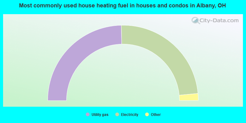
- 49.4%Utility gas
- 47.8%Electricity
- 2.0%Bottled, tank, or LP gas
- 0.8%Fuel oil, kerosene, etc.
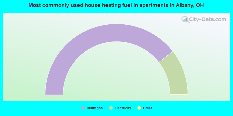
- 79.3%Utility gas
- 20.7%Electricity
Albany compared to Ohio state average:
- Unemployed percentage significantly below state average.
- Black race population percentage significantly below state average.
- Hispanic race population percentage below state average.
- Foreign-born population percentage significantly below state average.
- Length of stay since moving in above state average.
Albany on our top lists:
- #43 on the list of "Top 101 cities with the most residents born in Middle Africa (population 500+)"
- #72 (45710) on the list of "Top 101 zip codes with the largest percentage of Welsh first ancestries (pop 5,000+)"
- #52 on the list of "Top 101 counties with highest percentage of residents voting for 3rd party candidates in the 2012 Presidential Election (pop. 50,000+)"
- #77 on the list of "Top 101 counties with highest percentage of residents voting for Obama (Democrat) in the 2012 Presidential Election (pop. 50,000+)"
- #77 on the list of "Top 101 counties with the lowest surface withdrawal of fresh water for public supply (pop. 50,000+)"
- #84 on the list of "Top 101 counties with the largest number of people moving out compared to moving in (pop. 50,000+)"

|
|
Total of 27 patent applications in 2008-2024.