Cane Valley, Kentucky
Submit your own pictures of this place and show them to the world
- OSM Map
- General Map
- Google Map
- MSN Map

| Males: 761 | |
| Females: 789 |
| Median resident age: | 37.5 years |
| Kentucky median age: | 35.9 years |
Zip code: 42728
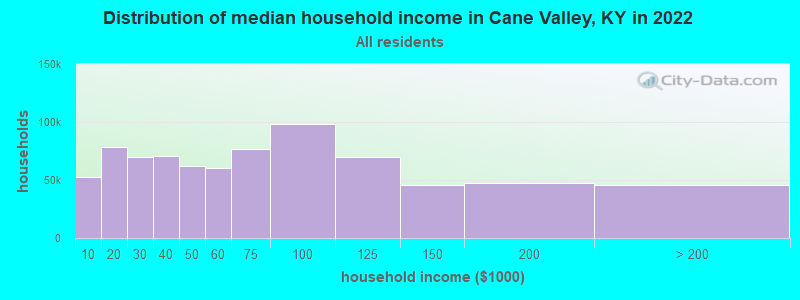
| Cane Valley: | $58,619 |
| KY: | $59,341 |
Estimated per capita income in 2022: $28,718 (it was $16,205 in 2000)
Cane Valley CCD income, earnings, and wages data
Estimated median house or condo value in 2022: $163,526 (it was $65,300 in 2000)
| Cane Valley: | $163,526 |
| KY: | $196,300 |
Mean prices in 2022: all housing units: $169,717; detached houses: $186,335; townhouses or other attached units: $186,093; mobile homes: $69,353; occupied boats, rvs, vans, etc.: $92,599
Detailed information about poverty and poor residents in Cane Valley, KY


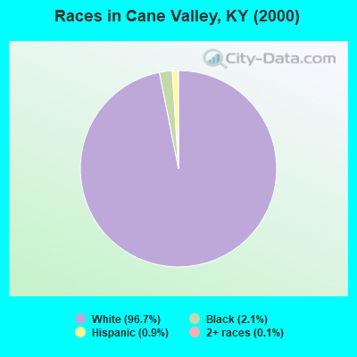
- 1,44896.7%White alone
- 322.1%Black alone
- 140.9%Hispanic
- 20.1%Two or more races
- 10.07%Native Hawaiian and Other
Pacific Islander alone
Races in Cane Valley detailed stats: ancestries, foreign born residents, place of birth
 Recent articles from our blog. Our writers, many of them Ph.D. graduates or candidates, create easy-to-read articles on a wide variety of topics.
Current Local Time: CST time zone
Elevation: 780 feet
Land area: 40.5 square miles.
Population density: 38 people per square mile (very low).

| Cane Valley CCD: | 0.5% ($337) |
| Kentucky: | 0.8% ($610) |
Nearest city with pop. 50,000+: Fayette, KY  (74.3 miles , pop. 260,512).
Nearest city with pop. 1,000,000+: Chicago, IL (346.0 miles , pop. 2,896,016).
Nearest cities:
), ), ), ), ), )Latitude: 37.18 N, Longitude: 85.32 W
Area code commonly used in this area: 270

| Here: | 4.7% |
| Kentucky: | 3.8% |
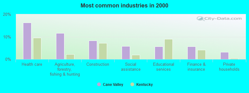
- Health care (16.2%)
- Agriculture, forestry, fishing & hunting (11.5%)
- Construction (8.2%)
- Social assistance (5.8%)
- Educational services (5.6%)
- Finance & insurance (5.6%)
- Private households (3.1%)
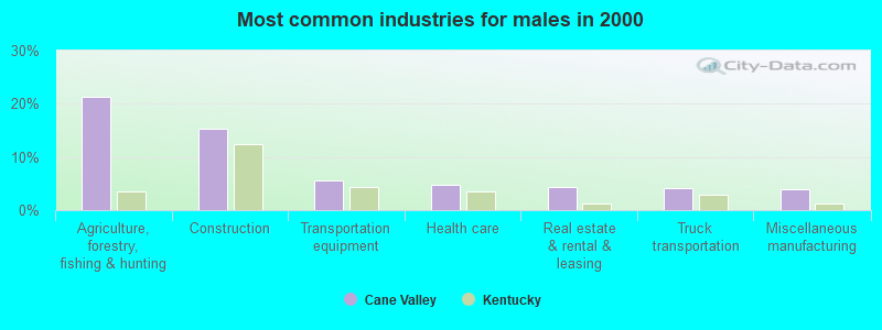
- Agriculture, forestry, fishing & hunting (21.3%)
- Construction (15.3%)
- Transportation equipment (5.6%)
- Health care (4.8%)
- Real estate & rental & leasing (4.4%)
- Truck transportation (4.1%)
- Miscellaneous manufacturing (3.9%)
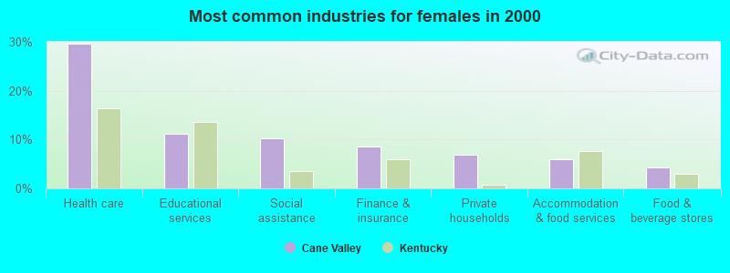
- Health care (29.6%)
- Educational services (11.1%)
- Social assistance (10.3%)
- Finance & insurance (8.5%)
- Private households (6.8%)
- Accommodation & food services (6.0%)
- Food & beverage stores (4.3%)
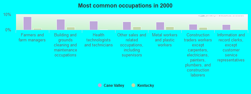
- Farmers and farm managers (8.6%)
- Building and grounds cleaning and maintenance occupations (6.9%)
- Health technologists and technicians (5.8%)
- Other sales and related occupations, including supervisors (5.2%)
- Metal workers and plastic workers (5.1%)
- Construction traders workers except carpenters, electricians, painters, plumbers, and construction laborers (3.7%)
- Information and record clerks, except customer service representatives (3.5%)
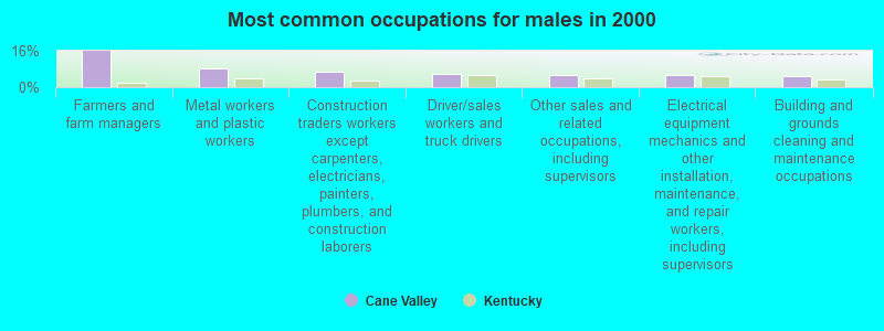
- Farmers and farm managers (16.0%)
- Metal workers and plastic workers (8.2%)
- Construction traders workers except carpenters, electricians, painters, plumbers, and construction laborers (6.8%)
- Driver/sales workers and truck drivers (6.1%)
- Other sales and related occupations, including supervisors (5.6%)
- Electrical equipment mechanics and other installation, maintenance, and repair workers, including supervisors (5.6%)
- Building and grounds cleaning and maintenance occupations (4.8%)
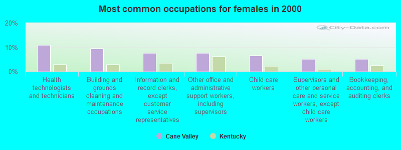
- Health technologists and technicians (10.8%)
- Building and grounds cleaning and maintenance occupations (9.4%)
- Information and record clerks, except customer service representatives (7.7%)
- Other office and administrative support workers, including supervisors (7.7%)
- Child care workers (6.6%)
- Supervisors and other personal care and service workers, except child care workers (5.1%)
- Bookkeeping, accounting, and auditing clerks (5.1%)
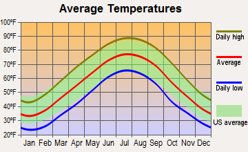
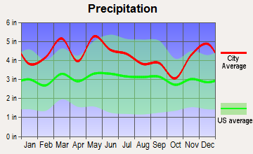
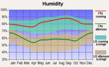
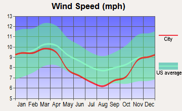
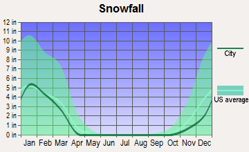
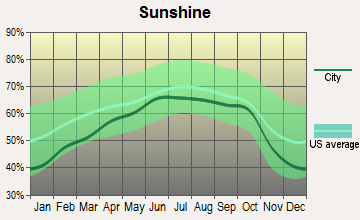
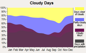
Average climate in Cane Valley, Kentucky
Based on data reported by over 4,000 weather stations
Tornado activity:
Cane Valley-area historical tornado activity is slightly above Kentucky state average. It is 43% greater than the overall U.S. average.
On 4/27/1971, a category F4 (max. wind speeds 207-260 mph) tornado 7.2 miles away from the Cane Valley place center killed 6 people and injured 58 people.
On 4/3/1974, a category F4 tornado 8.6 miles away from the place center injured 56 people and caused between $500,000 and $5,000,000 in damages.
Earthquake activity:
Cane Valley-area historical earthquake activity is significantly above Kentucky state average. It is 118% greater than the overall U.S. average.On 7/27/1980 at 18:52:21, a magnitude 5.2 (5.1 MB, 4.7 MS, 5.0 UK, 5.2 UK, Class: Moderate, Intensity: VI - VII) earthquake occurred 103.7 miles away from the city center
On 4/18/2008 at 09:36:59, a magnitude 5.4 (5.1 MB, 4.8 MS, 5.4 MW, 5.2 MW) earthquake occurred 165.4 miles away from the city center
On 4/18/2008 at 09:36:59, a magnitude 5.2 (5.2 MW, Depth: 8.9 mi) earthquake occurred 165.4 miles away from Cane Valley center
On 6/18/2002 at 17:37:15, a magnitude 5.0 (4.3 MB, 4.6 MW, 5.0 LG) earthquake occurred 145.8 miles away from the city center
On 6/10/1987 at 23:48:54, a magnitude 5.1 (4.9 MB, 4.4 MS, 4.6 MS, 5.1 LG) earthquake occurred 180.0 miles away from the city center
On 11/30/1973 at 07:48:41, a magnitude 4.7 (4.7 MB, 4.6 ML, Class: Light, Intensity: IV - V) earthquake occurred 121.8 miles away from the city center
Magnitude types: regional Lg-wave magnitude (LG), body-wave magnitude (MB), local magnitude (ML), surface-wave magnitude (MS), moment magnitude (MW)
Natural disasters:
The number of natural disasters in Adair County (17) is near the US average (15).Major Disasters (Presidential) Declared: 13
Emergencies Declared: 2
Causes of natural disasters: Floods: 9, Storms: 9, Tornadoes: 7, Winds: 4, Mudslides: 3, Winter Storms: 3, Landslides: 2, Blizzard: 1, Freeze: 1, Hurricane: 1, Snow: 1, Snowfall: 1, Snowstorm: 1, Other: 1 (Note: some incidents may be assigned to more than one category).
Hospitals and medical centers near Cane Valley:
- AMEDISYS HOME HEALTH (Home Health Center, about 5 miles away; COLUMBIA, KY)
- FAMILY HOME HEALTH CARE INC (Hospital, about 6 miles away; COLUMBIA, KY)
- PERSONAL TOUCH HOME CARE OF KY (Home Health Center, about 7 miles away; COLUMBIA, KY)
- GOLDEN LIVINGCENTER-GREEN HILL (Nursing Home, about 11 miles away; GREENSBURG, KY)
- GREEN HILL MANOR (Nursing Home, about 11 miles away; GREENSBURG, KY)
- CAMPBELLSVILLE NURSING AND REHABILITATION CENTER (Nursing Home, about 12 miles away; CAMPBELLSVILLE, KY)
- METZMEIER NH (Nursing Home, about 12 miles away; CAMPBELLSVILLE, KY)
Colleges/universities with over 2000 students nearest to Cane Valley:
- Lindsey Wilson College (about 6 miles; Columbia, KY; Full-time enrollment: 2,552)
- Campbellsville University (about 12 miles; Campbellsville, KY; FT enrollment: 2,948)
- Somerset Community College (about 40 miles; Somerset, KY; FT enrollment: 4,698)
- Elizabethtown Community and Technical College (about 47 miles; Elizabethtown, KY; FT enrollment: 3,762)
- Western Kentucky University (about 64 miles; Bowling Green, KY; FT enrollment: 16,942)
- Southcentral Kentucky Community and Technical College (about 66 miles; Bowling Green, KY; FT enrollment: 2,794)
- Eastern Kentucky University (about 69 miles; Richmond, KY; FT enrollment: 13,525)
Points of interest:
Churches in Cane Valley include: Hutchison Church (A), Mount Vernon Church (B), Plum Point Church (C), Sulphur Spring Church (D), Cane Valley Church (E), Charity Church (F), Egypt Christian Church (G). Display/hide their locations on the map
Cemeteries: Bryant Cemetery (1), Cane Valley Cemetery (2), Absher Cemetery (3), Henderson Cemetery (4), Hutchison Cemetery (5). Display/hide their locations on the map
Streams, rivers, and creeks: Sulphur Spring Branch (A), Butler Creek (B), Jones Branch (C), Russell Branch (D), Sandy Creek (E), Mill Creek (F), Pettys Fork (G). Display/hide their locations on the map
| This place: | 2.4 people |
| Kentucky: | 2.5 people |
| This place: | 71.4% |
| Whole state: | 66.9% |
| This place: | 5.9% |
| Whole state: | 6.4% |
Likely homosexual households (counted as self-reported same-sex unmarried-partner households)
- Lesbian couples: 0.6% of all households
- Gay men: 0.1% of all households
| This place: | 18.1% |
| Whole state: | 15.8% |
| This place: | 4.9% |
| Whole state: | 6.6% |
People in group quarters in Cane Valley in 2010:
- 17 people in residential treatment centers for juveniles (non-correctional)
- 11 people in group homes for juveniles (non-correctional)
- 4 people in group homes intended for adults
7 people in mental (psychiatric) hospitals or wards in 2000
For population 15 years and over in Cane Valley:
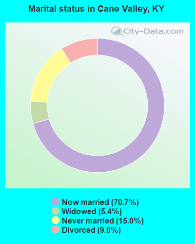
- Never married: 15.0%
- Now married: 70.7%
- Separated: 0.0%
- Widowed: 5.4%
- Divorced: 9.0%
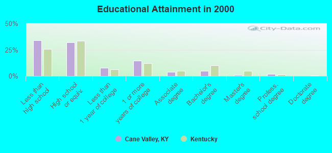
For population 25 years and over in Cane Valley:
- High school or higher: 65.9%
- Bachelor's degree or higher: 7.7%
- Graduate or professional degree: 2.8%
- Unemployed: 8.1%
- Mean travel time to work (commute): 24.1 minutes
| Here: | 13.7 |
| Kentucky average: | 13.8 |
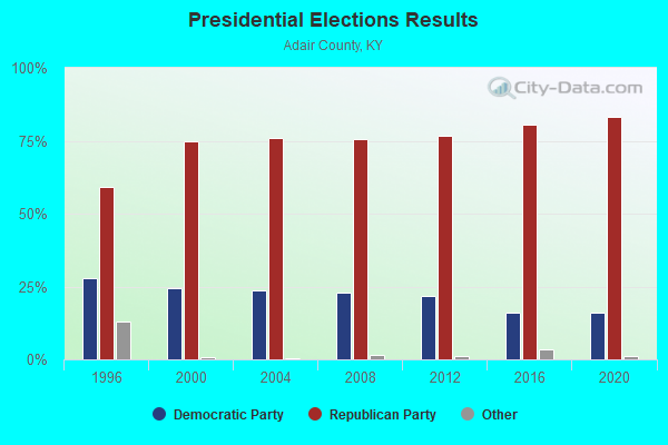
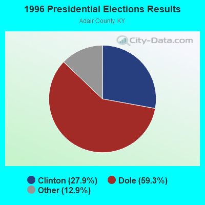
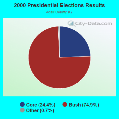
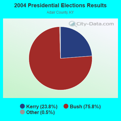
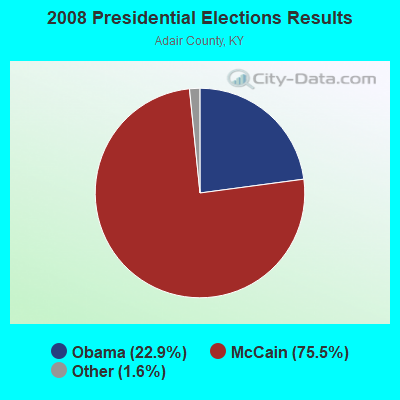
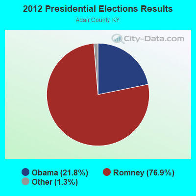
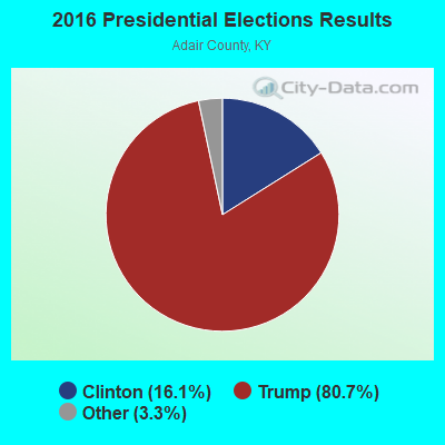
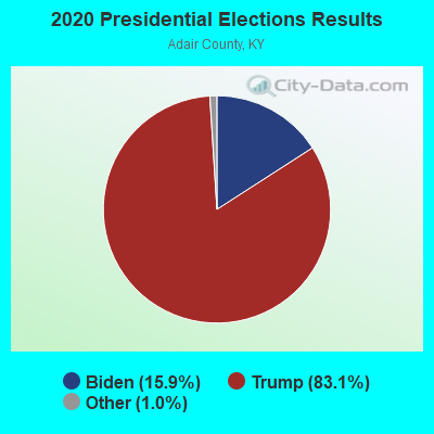
Graphs represent county-level data. Detailed 2008 Election Results
Religion statistics for Cane Valley, KY (based on Adair County data)
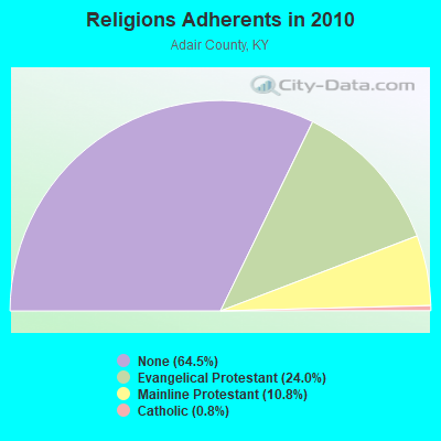
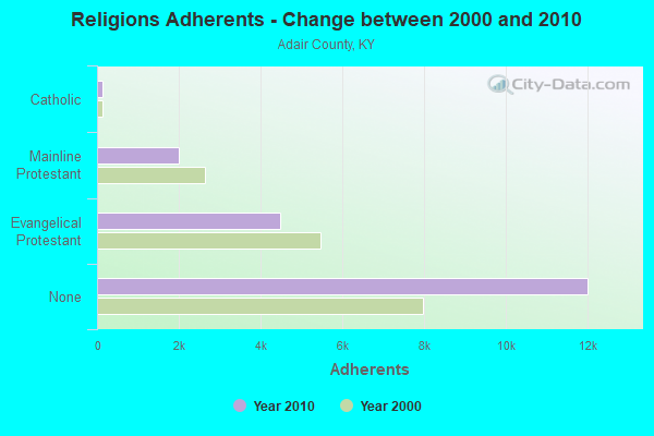
| Religion | Adherents | Congregations |
|---|---|---|
| Evangelical Protestant | 4,478 | 35 |
| Mainline Protestant | 2,011 | 16 |
| Catholic | 140 | 1 |
| Other | 2 | - |
| None | 12,025 | - |
Food Environment Statistics:
| Here: | 3.37 / 10,000 pop. |
| Kentucky: | 2.19 / 10,000 pop. |
| Here: | 5.61 / 10,000 pop. |
| State: | 4.36 / 10,000 pop. |
| Adair County: | 4.49 / 10,000 pop. |
| State: | 5.74 / 10,000 pop. |
| This county: | 12.5% |
| Kentucky: | 11.0% |
| This county: | 32.2% |
| State: | 30.0% |
| This county: | 15.3% |
| State: | 15.9% |
Strongest AM radio stations in Cane Valley:
- WAIN (1270 AM; 1 kW; COLUMBIA, KY)
- WHAS (840 AM; 50 kW; LOUISVILLE, KY; Owner: CLEAR CHANNEL BROADCASTING LICENSES, INC.)
- WTCO (1450 AM; 1 kW; CAMPBELLSVILLE, KY; Owner: CBC OF MARION & TAYLOR COUNTIES INC)
- WSM (650 AM; 50 kW; NASHVILLE, TN; Owner: GAYLORD ENTERTAINMENT COMPANY)
- WKVL (850 AM; daytime; 50 kW; KNOXVILLE, TN; Owner: HORNE RADIO, LLC)
- WAKY (1540 AM; 1 kW; GREENSBURG, KY; Owner: GREEN COUNTY CBC, INC.)
- WAMB (1160 AM; 50 kW; DONELSON, TN; Owner: GREAT SOUTHERN BROADCASTING COMPANY, INC.)
- WIDS (570 AM; 0 kW; RUSSELL SPRINGS, KY; Owner: HAMMOND BROADCASTING, INC.)
- WKDA (1200 AM; 50 kW; NASHVILLE, TN; Owner: RADIO NASHVILLE, INC.)
- WLAC (1510 AM; 50 kW; NASHVILLE, TN; Owner: CAPSTAR TX LIMITED PARTNERSHIP)
- WNQM (1300 AM; 50 kW; NASHVILLE, TN; Owner: WNQM. INC.)
- WJKY (1060 AM; daytime; 1 kW; JAMESTOWN, KY; Owner: LAKE CUMBERLAND BROADCASTERS)
- WWAM (820 AM; daytime; 50 kW; JASPER, TN; Owner: SHELTON BROADCASTING SYSTEM)
Strongest FM radio stations in Cane Valley:
- WDCL-FM (89.7 FM; SOMERSET, KY; Owner: WESTERN KENTUCKY UNIVERSITY)
- WAIN-FM (93.5 FM; COLUMBIA, KY; Owner: TRI-COUNTY RADIO BROADCASTING CORP.)
- WCKQ (104.1 FM; CAMPBELLSVILLE, KY; Owner: CBC OF MARION & TAYLOR COUNTIES INC)
- WGRK-FM (103.1 FM; GREENSBURG, KY; Owner: GREEN COUNTY CBC, INC.)
- WVLC (99.9 FM; MANNSVILLE, KY; Owner: PATRICIA RODGERS)
- WAPD (91.7 FM; CAMPBELLSVILLE, KY; Owner: AMERICAN FAMILY ASSOCIATION)
- WHVE (92.7 FM; RUSSELL SPRINGS, KY; Owner: SHORELINE COMMUNICATIONS, INC)
- WJRS (104.9 FM; JAMESTOWN, KY; Owner: LAKE CUMBERLAND BROADCASTERS)
- WKNK (99.1 FM; EDMONTON, KY; Owner: HART COUNTY COMMUNICATIONS, INC.)
- WXKY-FM (96.3 FM; STANFORD, KY; Owner: LINCOLN-GARRARD BROADCASTING CO.,INC)
TV broadcast stations around Cane Valley:
- WBKI-TV (Channel 34; CAMPBELLSVILLE, KY; Owner: LOUISVILLE COMMUNICATIONS, LLC)
- WKSO-TV (Channel 29; SOMERSET, KY; Owner: KENTUCKY AUTHORITY FOR EDUCATIONAL TV)
- W04BP (Channel 4; CAMPBELLSVILLE, KY; Owner: CAMPSVILLE UNIVERSITY)
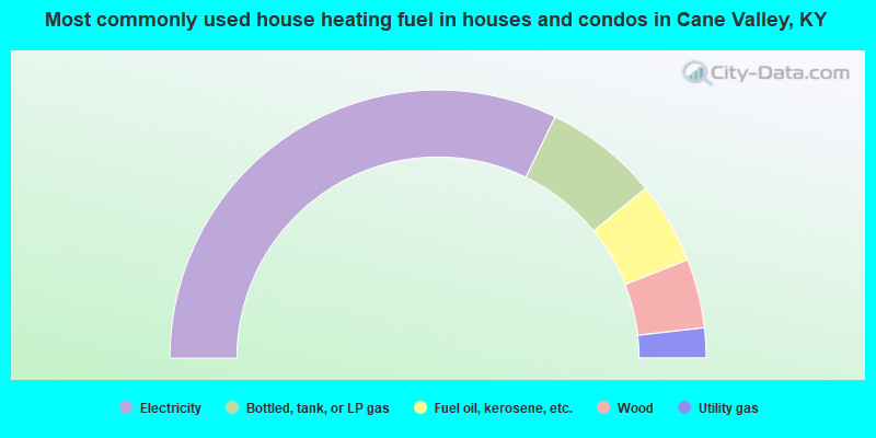
- 64.4%Electricity
- 13.8%Bottled, tank, or LP gas
- 9.9%Fuel oil, kerosene, etc.
- 8.3%Wood
- 3.6%Utility gas
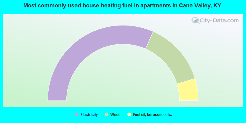
- 63.1%Electricity
- 27.4%Wood
- 9.5%Fuel oil, kerosene, etc.
Cane Valley compared to Kentucky state average:
- Unemployed percentage below state average.
- Black race population percentage significantly below state average.
- Hispanic race population percentage significantly below state average.
- Foreign-born population percentage significantly below state average.
- Renting percentage below state average.
- Length of stay since moving in significantly above state average.
- Number of rooms per house significantly below state average.
- House age significantly below state average.
- Number of college students below state average.
- Percentage of population with a bachelor's degree or higher significantly below state average.