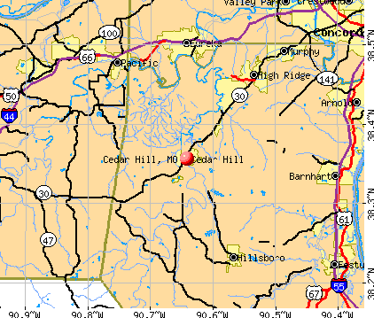
Cedar Hill, Missouri
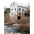
Cedar Hill: The mill on the Big River - another view
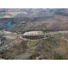
Cedar Hill: Medley Hill
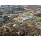
Cedar Hill: Northwest R-1 High School
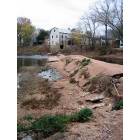
Cedar Hill: The mill on the Big River
- add
your
Submit your own pictures of this place and show them to the world
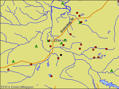
- OSM Map
- General Map
- Google Map
- MSN Map
Population change since 2000: +1.1%
| Males: 849 | |
| Females: 872 |
| Median resident age: | 32.2 years |
| Missouri median age: | 39.1 years |
Zip codes: 63016.
| Cedar Hill: | $79,135 |
| MO: | $64,811 |
Estimated per capita income in 2022: $34,863 (it was $15,599 in 2000)
Cedar Hill CDP income, earnings, and wages data
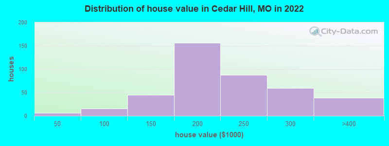
Estimated median house or condo value in 2022: $202,433 (it was $81,700 in 2000)
| Cedar Hill: | $202,433 |
| MO: | $221,200 |
Mean prices in 2022: all housing units: $198,063; detached houses: $199,293
Median gross rent in 2022: $836.
(17.7% for White Non-Hispanic residents, 65.5% for two or more races residents)
Detailed information about poverty and poor residents in Cedar Hill, MO
Compare current foreclosures near Cedar Hill, MO:
| Photo | Address | Area | Beds / Baths | Price | Details |
|---|---|---|---|---|---|

|
#1
Twilight Dr
Cedar Hill, MO 63016
|
630 sq. feet
|
2 baths - beds |
show details | |

|
#2
Veterans Dr
Cedar Hill, MO 63016
|
1,040 sq. feet
|
1 baths - beds |
show details | |

|
#3
Pete Obrien Rd
Cedar Hill, MO 63016
|
1,836 sq. feet
|
1 baths - beds |
show details | |

|
#4
Byrnesville Rd
Cedar Hill, MO 63016
|
1,500 sq. feet
|
2 baths - beds |
show details | |

|
#5
Hillview Dr
Cedar Hill, MO 63016
|
1,250 sq. feet
|
1 baths - beds |
show details | |

|
#6
Osage Lake Dr
Cedar Hill, MO 63016
|
1,934 sq. feet
|
2 baths - beds |
show details | |

|
#7
Wedgewood Dr
Cedar Hill, MO 63016
|
1,458 sq. feet
|
2 baths - beds |
show details | |

|
#8
Vista Dr
Cedar Hill, MO 63016
|
1,271 sq. feet
|
3 baths - beds |
show details | |

|
#9
Briarwood Dr
Cedar Hill, MO 63016
|
1,538 sq. feet
|
1 baths - beds |
show details | |

|
#10
Scenic View Dr
Cedar Hill, MO 63016
|
1,500 sq. feet
|
1 baths - beds |
show details |
| Photo | Address | Area | Beds / Baths | Price | Details |
|---|---|---|---|---|---|

|
#11
Crystal Ridge Ct
Cedar Hill, MO 63016
|
- sq. feet
|
- baths - beds |
show details | |

|
#12
Lake Dr
Cedar Hill, MO 63016
|
- sq. feet
|
- baths - beds |
show details | |

|
#13
Cross Pointe Dr
Cedar Hill, MO 63016
|
- sq. feet
|
- baths - beds |
show details | |

|
#14
Juliet Dr
Cedar Hill, MO 63016
|
- sq. feet
|
- baths - beds |
show details | |

|
#15
Lange Dr
Cedar Hill, MO 63016
|
- sq. feet
|
1 baths - beds |
show details | |

|
#16
Azelea Dr
Cedar Hill, MO 63016
|
- sq. feet
|
1 baths - beds |
show details | |

|
#17
State Road Bb
Cedar Hill, MO 63016
|
- sq. feet
|
- baths - beds |
show details | |

|
#18
Connor Rd
House Springs, MO 63051
|
1,076 sq. feet
|
2 baths 3 beds |
$227,000
|
show details |

|
#19
Forrest Acres
Barnhart, MO 63012
|
2,261 sq. feet
|
3 baths 3 beds |
$364,500
|
show details |

|
#20
Old State Route 21
Imperial, MO 63052
|
1,763 sq. feet
|
2 baths 3 beds |
$144,900
|
show details |
| Photo | Address | Area | Beds / Baths | Price | Details |
|---|---|---|---|---|---|

|
#21
Argonne Rd
Festus, MO 63028
|
1,048 sq. feet
|
1 baths 1 beds |
$144,500
|
show details |

|
#22
Mallet Hl
Ballwin, MO 63021
|
4,530 sq. feet
|
4 baths 5 beds |
$649,900
|
show details |

|
#23
Oak Crest Ct
Barnhart, MO 63012
|
2,255 sq. feet
|
3 baths 3 beds |
show details | |

|
#24
Big Bend Rd
Ballwin, MO 63021
|
1,594 sq. feet
|
2 baths 4 beds |
show details | |

|
#25
Highway Hh
Catawissa, MO 63015
|
1,339 sq. feet
|
2 baths 3 beds |
show details | |

|
#26
Sheraton Ln
Herculaneum, MO 63048
|
1,236 sq. feet
|
1 baths 3 beds |
show details | |

|
#27
Highway Pp
High Ridge, MO 63049
|
1,105 sq. feet
|
1 baths 3 beds |
show details | |

|
#28
W Hawthorne St
Pacific, MO 63069
|
1,292 sq. feet
|
1 baths 3 beds |
show details | |

|
#29
W Miller St
De Soto, MO 63020
|
1,910 sq. feet
|
2 baths 3 beds |
show details | |

|
#30
Landolt Ln
Hillsboro, MO 63050
|
1,362 sq. feet
|
2 baths 3 beds |
show details |
| Photo | Address | Area | Beds / Baths | Price | Details |
|---|---|---|---|---|---|

|
#31
Dover Trace Dr
Fenton, MO 63026
|
4,046 sq. feet
|
4 baths 4 beds |
show details | |

|
#32
Valley Glenn Dr
Robertsville, MO 63072
|
2,356 sq. feet
|
3 baths 4 beds |
show details | |

|
#33
Center Dr
High Ridge, MO 63049
|
912 sq. feet
|
2 baths 3 beds |
show details | |

|
#34
Morse Ave
De Soto, MO 63020
|
392 sq. feet
|
1 baths 3 beds |
show details | |

|
#35
Burgan Grove Rd
House Springs, MO 63051
|
2,355 sq. feet
|
3 baths 3 beds |
show details | |

|
#36
Woodrun Dr
Ballwin, MO 63021
|
1,310 sq. feet
|
3 baths 3 beds |
show details | |

|
#37
Butler Dr
Eureka, MO 63025
|
966 sq. feet
|
1 baths 3 beds |
show details | |

|
#38
Redbud Dr
Lonedell, MO 63060
|
3,089 sq. feet
|
2 baths 3 beds |
show details | |

|
#39
Cambridge Rd
High Ridge, MO 63049
|
1,040 sq. feet
|
1 baths 3 beds |
show details | |

|
#40
Sundale Ct
Eureka, MO 63025
|
2,604 sq. feet
|
3 baths 4 beds |
show details |
| Photo | Address | Area | Beds / Baths | Price | Details |
|---|---|---|---|---|---|

|
#41
Forest Springs Ln
Ballwin, MO 63021
|
914 sq. feet
|
2 baths 2 beds |
show details | |

|
#42
Waterside Dr
Grover, MO 63040
|
1,604 sq. feet
|
2 baths 2 beds |
show details | |

|
#43
Copperwood Ln
Grover, MO 63040
|
2,456 sq. feet
|
3 baths 4 beds |
show details | |

|
#44
Glenbarr Ct
Valley Park, MO 63088
|
1,402 sq. feet
|
2 baths 3 beds |
show details | |

|
#45
Cove Landing Dr
Grover, MO 63040
|
2,116 sq. feet
|
4 baths 4 beds |
show details | |

|
#46
Laurel Park Ct
Grover, MO 63040
|
2,026 sq. feet
|
2 baths 3 beds |
show details | |

|
#47
Lighthouse Ct
Villa Ridge, MO 63089
|
1,834 sq. feet
|
3 baths 2 beds |
show details | |

|
#48
Port Of Nantucket Dr
Grover, MO 63040
|
1,556 sq. feet
|
2 baths 3 beds |
show details | |

|
#49
Greenfield Crossing Ct
Ballwin, MO 63021
|
1,986 sq. feet
|
2 baths 4 beds |
show details | |

|
Check over 1 million property listings on Foreclosure.com!
|
browse all offers | |||


- 1,33390.8%White alone
- 936.3%Two or more races
- 342.3%Hispanic
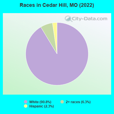
Races in Cedar Hill detailed stats: ancestries, foreign born residents, place of birth
According to our research of Missouri and other state lists, there were 28 registered sex offenders living in Cedar Hill, Missouri as of April 28, 2024.
The ratio of all residents to sex offenders in Cedar Hill is 65 to 1.
 Recent articles from our blog. Our writers, many of them Ph.D. graduates or candidates, create easy-to-read articles on a wide variety of topics.


Latest news from Cedar Hill, MO collected exclusively by city-data.com from local newspapers, TV, and radio stations
Ancestries: German (21.2%), Scotch-Irish (17.9%), Irish (15.8%), Italian (6.8%), Polish (4.6%), European (3.7%).
Current Local Time: CST time zone
Elevation: 550 feet
Land area: 2.30 square miles.
Population density: 749 people per square mile (low).
8 residents are foreign born
| This place: | 0.5% |
| Missouri: | 2.7% |
Median real estate property taxes paid for housing units with mortgages in 2022: $1,846 (1.0%)
Median real estate property taxes paid for housing units with no mortgage in 2022: $1,415 (0.6%)
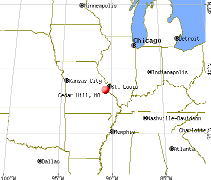
Nearest city with pop. 50,000+: St. Louis, MO  (28.6 miles , pop. 348,189).
Nearest city with pop. 1,000,000+: Chicago, IL (287.4 miles , pop. 2,896,016).
Nearest cities:
), ), ), ), Latitude: 38.36 N, Longitude: 90.64 W
Area code: 636
| Here: | 2.6% |
| Missouri: | 2.8% |
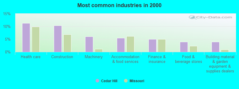
- Health care (11.2%)
- Construction (10.4%)
- Machinery (6.0%)
- Accommodation & food services (5.5%)
- Finance & insurance (5.0%)
- Food & beverage stores (4.0%)
- Building material & garden equipment & supplies dealers (4.0%)
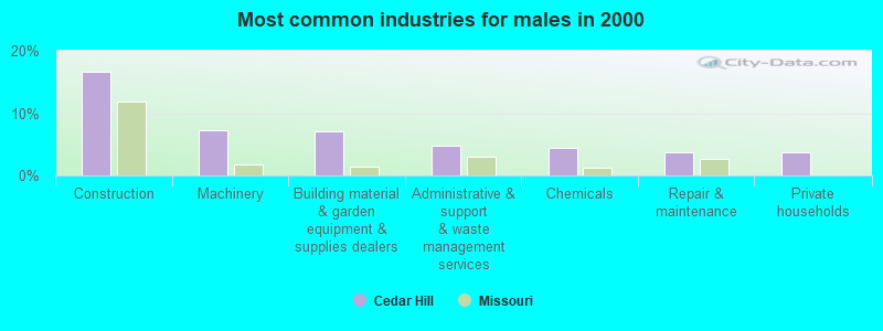
- Construction (16.6%)
- Machinery (7.3%)
- Building material & garden equipment & supplies dealers (7.1%)
- Administrative & support & waste management services (4.9%)
- Chemicals (4.4%)
- Repair & maintenance (3.8%)
- Private households (3.8%)
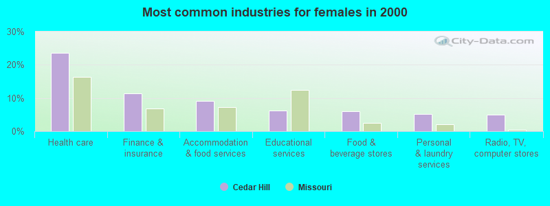
- Health care (23.5%)
- Finance & insurance (11.5%)
- Accommodation & food services (9.2%)
- Educational services (6.3%)
- Food & beverage stores (6.0%)
- Personal & laundry services (5.2%)
- Radio, TV, computer stores (4.9%)
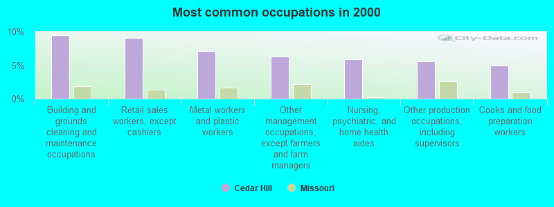
- Building and grounds cleaning and maintenance occupations (9.5%)
- Retail sales workers, except cashiers (9.1%)
- Metal workers and plastic workers (7.1%)
- Other management occupations, except farmers and farm managers (6.2%)
- Nursing, psychiatric, and home health aides (5.9%)
- Other production occupations, including supervisors (5.6%)
- Cooks and food preparation workers (5.0%)
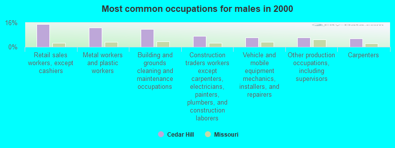
- Retail sales workers, except cashiers (15.0%)
- Metal workers and plastic workers (12.6%)
- Building and grounds cleaning and maintenance occupations (11.7%)
- Construction traders workers except carpenters, electricians, painters, plumbers, and construction laborers (7.3%)
- Vehicle and mobile equipment mechanics, installers, and repairers (6.2%)
- Other production occupations, including supervisors (6.2%)
- Carpenters (5.5%)
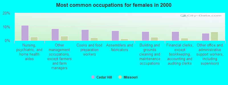
- Nursing, psychiatric, and home health aides (11.2%)
- Other management occupations, except farmers and farm managers (8.6%)
- Cooks and food preparation workers (8.0%)
- Assemblers and fabricators (7.2%)
- Building and grounds cleaning and maintenance occupations (6.6%)
- Financial clerks, except bookkeeping, accounting and auditing clerks (6.6%)
- Other office and administrative support workers, including supervisors (5.4%)
Average climate in Cedar Hill, Missouri
Based on data reported by over 4,000 weather stations


|
|

(lower is better)
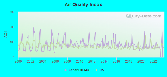
Air Quality Index (AQI) level in 2022 was 71.0. This is about average.
| City: | 71.0 |
| U.S.: | 72.6 |
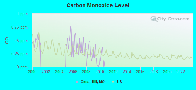
Carbon Monoxide (CO) [ppm] level in 2010 was 0.185. This is better than average. Closest monitor was 18.6 miles away from the city center.
| City: | 0.185 |
| U.S.: | 0.251 |
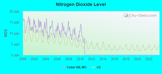
Nitrogen Dioxide (NO2) [ppb] level in 2010 was 9.17. This is significantly worse than average. Closest monitor was 16.2 miles away from the city center.
| City: | 9.17 |
| U.S.: | 5.11 |
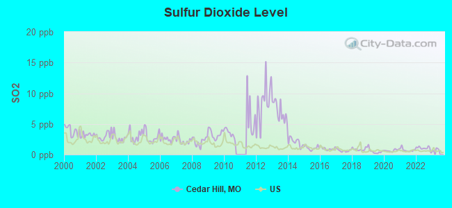
Sulfur Dioxide (SO2) [ppb] level in 2022 was 1.04. This is significantly better than average. Closest monitor was 15.5 miles away from the city center.
| City: | 1.04 |
| U.S.: | 1.51 |
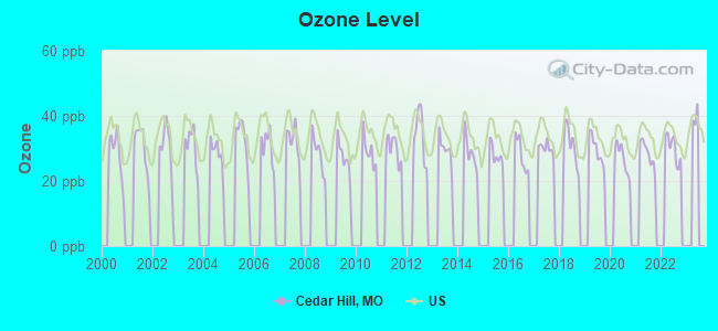
Ozone [ppb] level in 2022 was 30.1. This is about average. Closest monitor was 9.9 miles away from the city center.
| City: | 30.1 |
| U.S.: | 33.3 |
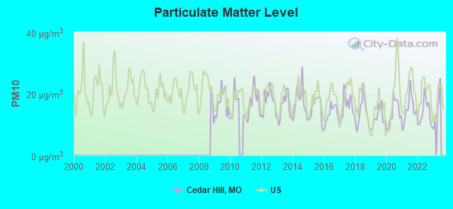
Particulate Matter (PM10) [µg/m3] level in 2022 was 13.8. This is better than average. Closest monitor was 14.8 miles away from the city center.
| City: | 13.8 |
| U.S.: | 19.2 |
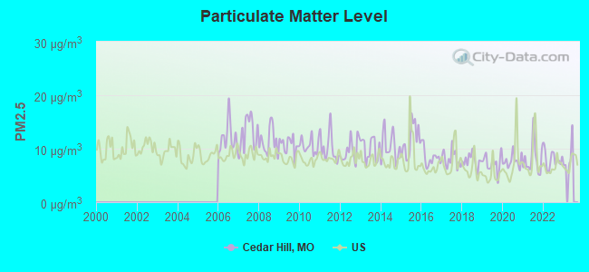
Particulate Matter (PM2.5) [µg/m3] level in 2022 was 8.06. This is about average. Closest monitor was 14.8 miles away from the city center.
| City: | 8.06 |
| U.S.: | 8.11 |
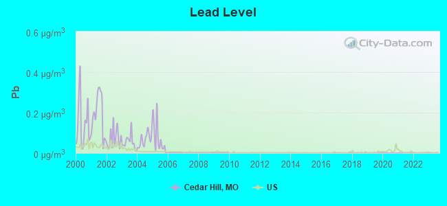
Lead (Pb) [µg/m3] level in 2005 was 0.0821. This is significantly worse than average. Closest monitor was 14.9 miles away from the city center.
| City: | 0.0821 |
| U.S.: | 0.0093 |
Tornado activity:
Cedar Hill-area historical tornado activity is near Missouri state average. It is 66% greater than the overall U.S. average.
On 2/10/1959, a category F4 (max. wind speeds 207-260 mph) tornado 12.2 miles away from the Cedar Hill place center killed 21 people and injured 345 people and caused between $5,000,000 and $50,000,000 in damages.
On 2/24/1956, a category F4 tornado 16.4 miles away from the place center killed 6 people and injured 36 people and caused between $500,000 and $5,000,000 in damages.
Earthquake activity:
Cedar Hill-area historical earthquake activity is significantly above Missouri state average. It is 350% greater than the overall U.S. average.On 4/18/2008 at 09:36:59, a magnitude 5.4 (5.1 MB, 4.8 MS, 5.4 MW, 5.2 MW, Class: Moderate, Intensity: VI - VII) earthquake occurred 149.5 miles away from Cedar Hill center
On 9/26/1990 at 13:18:51, a magnitude 5.0 (4.7 MB, 4.8 LG, 5.0 LG, Depth: 7.7 mi) earthquake occurred 102.1 miles away from the city center
On 4/18/2008 at 09:36:59, a magnitude 5.2 (5.2 MW, Depth: 8.9 mi) earthquake occurred 149.5 miles away from Cedar Hill center
On 6/10/1987 at 23:48:54, a magnitude 5.1 (4.9 MB, 4.4 MS, 4.6 MS, 5.1 LG) earthquake occurred 152.5 miles away from the city center
On 5/4/1991 at 01:18:54, a magnitude 5.0 (4.4 MB, 4.6 LG, 5.0 LG, Depth: 3.1 mi) earthquake occurred 131.9 miles away from Cedar Hill center
On 6/18/2002 at 17:37:15, a magnitude 5.0 (4.3 MB, 4.6 MW, 5.0 LG) earthquake occurred 157.7 miles away from the city center
Magnitude types: regional Lg-wave magnitude (LG), body-wave magnitude (MB), surface-wave magnitude (MS), moment magnitude (MW)
Natural disasters:
The number of natural disasters in Jefferson County (27) is a lot greater than the US average (15).Major Disasters (Presidential) Declared: 16
Emergencies Declared: 7
Causes of natural disasters: Storms: 19, Floods: 18, Tornadoes: 15, Winds: 4, Winter Storms: 3, Drought: 1, Flash Flood: 1, Heavy Rain: 1, Hurricane: 1, Other: 1 (Note: some incidents may be assigned to more than one category).
Hospitals and medical centers in Cedar Hill:
Other hospitals and medical centers near Cedar Hill:
- MARYMOUNT MANOR (Nursing Home, about 10 miles away; EUREKA, MO)
- AMEDISYS HOME HEALTH OF MISSOURI (Home Health Center, about 10 miles away; HILLSBORO, MO)
- PRICE MEMORIAL (Nursing Home, about 11 miles away; EUREKA, MO)
- EUREKA DIALYSIS CENTER (Dialysis Facility, about 12 miles away; EUREKA, MO)
- SOUTH COUNTY MANOR (Nursing Home, about 14 miles away; ARNOLD, MO)
- SOUTH COUNTY NURSING HOME INC (Nursing Home, about 14 miles away; ARNOLD, MO)
- BENCHMARK HEALTHCARE OF WILDWOOD (Nursing Home, about 14 miles away; WILDWOOD, MO)
Colleges/universities with over 2000 students nearest to Cedar Hill:
- Jefferson College (about 9 miles; Hillsboro, MO; Full-time enrollment: 3,975)
- East Central College (about 19 miles; Union, MO; FT enrollment: 2,810)
- Maryville University of Saint Louis (about 22 miles; Saint Louis, MO; FT enrollment: 3,651)
- Missouri Baptist University (about 23 miles; Saint Louis, MO; FT enrollment: 2,898)
- Webster University (about 23 miles; Saint Louis, MO; FT enrollment: 12,406)
- Washington University in St Louis (about 27 miles; Saint Louis, MO; FT enrollment: 10,823)
- St Charles Community College (about 28 miles; Cottleville, MO; FT enrollment: 5,302)
Public high school in Cedar Hill:
- NORTHWEST HIGH (Students: 2,359, Location: 6005 CEDAR HILL RD, Grades: 9-12)
Points of interest:
Notable location: Cedar Hill Fire Protection District Station 1 (A). Display/hide its location on the map
Church in Cedar Hill: Cedar Hill Church (A). Display/hide its location on the map
Drinking water stations with addresses in Cedar Hill and their reported violations in the past:
EVERGREEN LAKE ESTATES (Population served: 85, Groundwater):Past monitoring violations:FICKEN HILL SUBD (Population served: 45, Groundwater):
- 2 routine major monitoring violations
- One minor monitoring violation
Past health violations:Past monitoring violations:
- MCL, Monthly (TCR) - In AUG-2012, Contaminant: Coliform. Follow-up actions: St Public Notif requested (SEP-05-2012), St Formal NOV issued (SEP-05-2012), St Public Notif received (OCT-05-2012), St Compliance achieved (JAN-22-2014)
- MCL, Monthly (TCR) - In JUL-2011, Contaminant: Coliform. Follow-up actions: St Public Notif requested (AUG-04-2011), St Violation/Reminder Notice (AUG-04-2011), St Compliance achieved (SEP-06-2011)
- MCL, Monthly (TCR) - In JUL-2008, Contaminant: Coliform. Follow-up actions: St Violation/Reminder Notice (JUL-17-2008), St Public Notif requested (JUL-17-2008), St Public Notif received (JUN-04-2009), St Compliance achieved (JAN-22-2014)
- Monitoring, Source Water (GWR) - In JUL-01-2011, Contaminant: E. COLI. Follow-up actions: St Public Notif requested (AUG-23-2011), St Violation/Reminder Notice (AUG-23-2011), St Public Notif received (JUL-19-2012)
| This place: | 2.7 people |
| Missouri: | 2.5 people |
| This place: | 70.5% |
| Whole state: | 65.3% |
| This place: | 11.1% |
| Whole state: | 6.7% |
Likely homosexual households (counted as self-reported same-sex unmarried-partner households)
- Lesbian couples: 0.5% of all households
- Gay men: 0.3% of all households
Banks with branches in Cedar Hill (2011 data):
- Eagle Bank and Trust Company of Missouri: Drive-In Facility at Old Highway 30 And Bb, branch established on 1974/03/22. Info updated 2012/02/21: Bank assets: $836.9 mil, Deposits: $681.2 mil, headquarters in Hillsboro, MO, positive income, Commercial Lending Specialization, 17 total offices, Holding Company: Jefferson County Bancshares, Incorporated
For population 15 years and over in Cedar Hill:
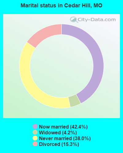
- Never married: 38.0%
- Now married: 42.4%
- Separated: 0.0%
- Widowed: 4.2%
- Divorced: 15.3%
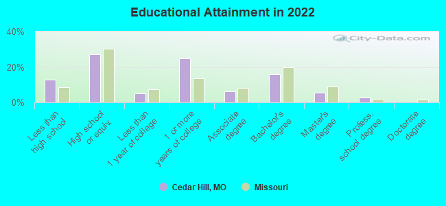
For population 25 years and over in Cedar Hill:
- High school or higher: 86.0%
- Bachelor's degree or higher: 19.8%
- Graduate or professional degree: 5.8%
- Unemployed: 12.3%
- Mean travel time to work (commute): 30.3 minutes
| Here: | 14.3 |
| Missouri average: | 11.1 |
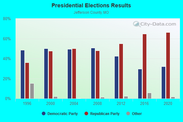
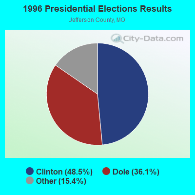
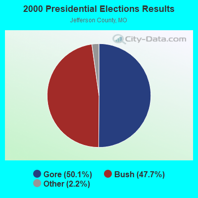
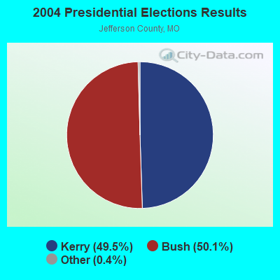
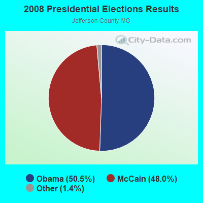
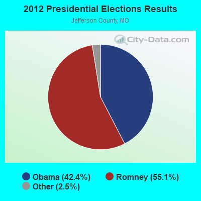
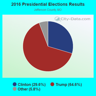
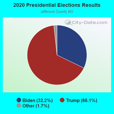
Graphs represent county-level data. Detailed 2008 Election Results
Religion statistics for Cedar Hill, MO (based on Jefferson County data)
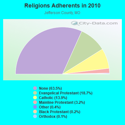
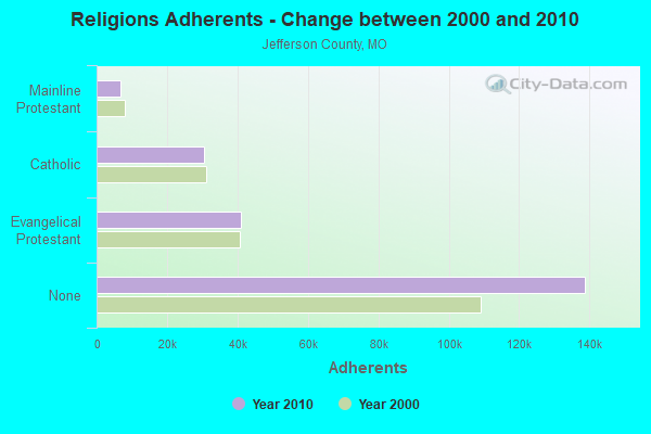
| Religion | Adherents | Congregations |
|---|---|---|
| Evangelical Protestant | 40,846 | 107 |
| Catholic | 30,495 | 11 |
| Mainline Protestant | 6,917 | 31 |
| Other | 925 | 9 |
| Black Protestant | 496 | 3 |
| Orthodox | 260 | 1 |
| None | 138,794 | - |
Food Environment Statistics:
| Jefferson County: | 1.07 / 10,000 pop. |
| Missouri: | 1.88 / 10,000 pop. |
| Jefferson County: | 0.05 / 10,000 pop. |
| Missouri: | 0.18 / 10,000 pop. |
| Jefferson County: | 0.70 / 10,000 pop. |
| Missouri: | 0.60 / 10,000 pop. |
| Here: | 3.66 / 10,000 pop. |
| State: | 4.34 / 10,000 pop. |
| This county: | 4.40 / 10,000 pop. |
| State: | 7.37 / 10,000 pop. |
| Here: | 9.1% |
| Missouri: | 8.8% |
| Here: | 29.5% |
| State: | 29.6% |
| Here: | 14.5% |
| Missouri: | 13.5% |
Health and Nutrition:
| This city: | 45.2% |
| State: | 50.9% |
| This city: | 41.3% |
| Missouri: | 48.6% |
| Cedar Hill: | 29.3 |
| Missouri: | 28.7 |
| Here: | 29.2% |
| State: | 20.6% |
| Cedar Hill: | 9.2% |
| Missouri: | 10.1% |
| This city: | 6.8 |
| State: | 6.8 |
| Cedar Hill: | 36.6% |
| Missouri: | 34.3% |
| This city: | 53.3% |
| State: | 57.5% |
| This city: | 77.7% |
| Missouri: | 79.3% |
More about Health and Nutrition of Cedar Hill, MO Residents
Businesses in Cedar Hill, MO
- Circle K: 1
Strongest AM radio stations in Cedar Hill:
- KXEN (1010 AM; 50 kW; FESTUS-ST. LOUIS, MO; Owner: BDJ RADIO ENTERPRISES, LLC)
- KMOX (1120 AM; 50 kW; ST. LOUIS, MO; Owner: INFINITY BROADCASTING OPERATIONS, INC.)
- WSDZ (1260 AM; 20 kW; BELLEVILLE, IL)
- KFUO (850 AM; 5 kW; CLAYTON, MO; Owner: LUTHERAN CHURCH-MISSOURI SYNOD)
- KTRS (550 AM; 5 kW; ST. LOUIS, MO; Owner: KTRS-AM LICENSE, L.L.C.)
- KSIV (1320 AM; 5 kW; CLAYTON, MO; Owner: BOTT COMMUNICATIONS, INC.)
- KSLG (1380 AM; 5 kW; ST. LOUIS, MO; Owner: NEW HORIZON 7TH-DAY CHRISTIAN CHURCH, INC.)
- KJSL (630 AM; 5 kW; ST. LOUIS, MO; Owner: WMUZ RADIO, INC.)
- KRFT (1190 AM; 10 kW; DE SOTO, MO; Owner: ALL SPORTS RADIO, LLC)
- WRTH (1430 AM; 5 kW; ST. LOUIS, MO)
- KIRL (1460 AM; 5 kW; ST. CHARLES, MO; Owner: BRONCO BROADCASTING CO., INC.)
- KJFF (1400 AM; 1 kW; FESTUS, MO; Owner: KREI, INC.)
- KATZ (1600 AM; 5 kW; ST. LOUIS, MO; Owner: CITICASTERS LICENSES, L.P.)
Strongest FM radio stations in Cedar Hill:
- KNLH (89.5 FM; CEDAR HILL, MO; Owner: NEW LIFE EVANGELISTIC CENTER, INC.)
- KPNT (105.7 FM; ST. GENEVIEVE, MO; Owner: EMMIS RADIO LICENSE CORPORATION)
- KDHX (88.1 FM; ST. LOUIS, MO; Owner: DOUBLE HELIX CORPORATION)
- WIL-FM (92.3 FM; ST. LOUIS, MO; Owner: BONNEVILLE HOLDING COMPANY)
- KSD (93.7 FM; ST. LOUIS, MO; Owner: CITICASTERS LICENSES, L.P.)
- KSLZ (107.7 FM; ST. LOUIS, MO; Owner: CITICASTERS LICENSES, L.P.)
- KFUO-FM (99.1 FM; CLAYTON, MO; Owner: THE LUTHERAN CHURCH-MISSOURI SYNOD)
- KYKY (98.1 FM; ST. LOUIS, MO; Owner: INFINITY RADIO SUBSIDIARY OPERATIONS INC.)
- WSSM (106.5 FM; GRANITE CITY, IL; Owner: BONNEVILLE HOLDING COMPANY)
- KSHE (94.7 FM; CRESTWOOD, MO; Owner: EMMIS RADIO LICENSE CORPORATION)
- KWMU (90.7 FM; ST. LOUIS, MO; Owner: THE CURATORS OF THE UNIVERSITY OF MISSOURI)
- KLOU (103.3 FM; ST. LOUIS, MO; Owner: CITICASTERS LICENSES, L.P.)
- KEZK-FM (102.5 FM; ST. LOUIS, MO; Owner: INFINITY RADIO SUBSIDIARY OPERATIONS INC.)
- KIHT (96.3 FM; ST. LOUIS, MO; Owner: EMMIS RADIO LICENSE CORPORATION)
- KNSX (93.3 FM; STEELVILLE, MO; Owner: TWENTY-ONE SOUND COMMUNICATIONS, INC)
- KSIV-FM (91.5 FM; ST. LOUIS, MO; Owner: COMMUNITY BROADCASTING, INC.)
- KTBJ (89.3 FM; FESTUS, MO; Owner: CSN INTERNATIONAL)
- KSLQ-FM (104.5 FM; WASHINGTON, MO; Owner: Y2K, INC.)
- KLPW-FM (101.7 FM; UNION, MO; Owner: MARATHON MEDIA GROUP, L.L.C.)
- KMJM-FM (104.9 FM; COLUMBIA, IL; Owner: CITICASTERS LICENSES, L.P.)
TV broadcast stations around Cedar Hill:
- KNLC (Channel 24; ST. LOUIS, MO; Owner: NEW LIFE EVANGELISTIC CENTER, INC.)
- WRBU (Channel 46; EAST ST. LOUIS, IL; Owner: ROBERTS BROADCASTING COMPANY)
- KETC (Channel 9; ST. LOUIS, MO; Owner: ST. LOUIS REGIONAL & EDUCATIONAL PUBLIC TV COMMISSION)
- KTVI (Channel 2; ST. LOUIS, MO; Owner: KTVI LICENSE, INC.)
- KSDK (Channel 5; ST. LOUIS, MO; Owner: MULTIMEDIA KSDK, INC.)
- KPLR-TV (Channel 11; ST. LOUIS, MO; Owner: KPLR, INC.)
- KMOV (Channel 4; ST. LOUIS, MO; Owner: KMOV-TV, INC.)
- KDNL-TV (Channel 30; ST. LOUIS, MO; Owner: KDNL LICENSEE, LLC)
- K63FW (Channel 63; JAMESTOWN, MO; Owner: ROGER E. HARDERS)
- K62EG (Channel 62; ST. LOUIS, MO; Owner: ETERNAL FAMILY NETWORK)
- KPTN-LP (Channel 58; ST. LOUIS, MO; Owner: KURT J. PETERSEN)
- K40FF (Channel 40; ST. LOUIS, MO; Owner: EBC ST. LOUIS, INC.)
- K18BT (Channel 18; ST. LOUIS, MO; Owner: TRINITY BROADCASTING NETWORK)
- K65FN (Channel 65; BATESVILLE, AR; Owner: MS COMMUNICATIONS, LLC)
- K49FC (Channel 49; ST. LOUIS, MO; Owner: THREE ANGELS BROADCASTING NETWORK)
- K64DT (Channel 64; ST. LOUIS, MO; Owner: WORD OF GOD FELLOWSHIP, INC.)
- K59GP (Channel 59; ST. CHARLES, MO; Owner: TRINITY BROADCASTING NETWORK)
- Cedar Hill, Missouri
- Fatal accident count14
- Vehicles involved in fatal accidents20
- Fatal accidents involving drunk persons:4
- Fatalities17
- Persons involved in fatal accidents31
- Pedestrians involved in fatal accidents1
- Missouri average
- Fatal accident count9517
- Vehicles involved in fatal accidents14370
- Fatal accidents involving drunk persons3114
- Fatalities10577
- Persons involved in fatal accidents23152
- Pedestrians involved in fatal accidents1055
- National Bridge Inventory (NBI) Statistics
- 17Number of bridges
- 266ft / 80.6mTotal length
- $631,000Total costs
- 59,897Total average daily traffic
- 5,197Total average daily truck traffic
- 103,192Total future (year 2041) average daily traffic
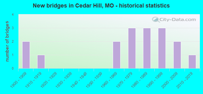
- New bridges - historical statistics
- 21900-1909
- 11910-1919
- 21960-1969
- 31970-1979
- 31980-1989
- 31990-1999
- 22000-2009
- 12010-2019
FCC Registered Cell Phone Towers:
1 (See the full list of FCC Registered Cell Phone Towers in Cedar Hill)FCC Registered Antenna Towers:
34 (See the full list of FCC Registered Antenna Towers)FCC Registered Broadcast Land Mobile Towers:
2- BACKUP CENTER, 7610 Veterans Boulevard (Lat: 38.353389 Lon: -90.647750), Type: Bant, Structure height: 5.2 m, Overall height: 6.1 m, Call Sign: WQWB407,
Assigned Frequencies: 155.115 MHz, Grant Date: 07/08/2015, Expiration Date: 07/08/2025, Certifier: Travis Williams, Registrant: Midwest Radio Systems, Inc., 216 Roberta Dr., Bismarck, MO 63624-9616, Phone: (573) 734-2355, Fax: (573) 734-1119, Email:
- Lat: 38.343861 Lon: -90.605417, Call Sign: WQZD467,
Assigned Frequencies: 151.505 MHz, 151.505 MHz, 158.400 MHz, 158.400 MHz, 151.625 MHz, 151.700 MHz, Grant Date: 04/12/2017, Expiration Date: 04/12/2027, Certifier: Steven L Welton, Registrant: Tri-Sar Association, 9847 Arv-Ellen Drive, Affton, MO 63123, Phone: (314) 941-8500, Email:
FCC Registered Microwave Towers:
10 (See the full list of FCC Registered Microwave Towers in this town)FCC Registered Amateur Radio Licenses:
35 (See the full list of FCC Registered Amateur Radio Licenses in Cedar Hill)FAA Registered Aircraft:
6- Aircraft: CESSNA 150F (Category: Land, Seats: 2, Weight: Up to 12,499 Pounds, Speed: 90 mph), Engine: CONT MOTOR 0-200 SERIES (100 HP) (Reciprocating)
N-Number: 3028X, N3028X, N-3028X, Serial Number: 15064428, Year manufactured: 1966, Airworthiness Date: 10/19/1966, Certificate Issue Date: 10/15/2004
Registrant (Individual): Jerome L Ficken, Po Box 245, Cedar Hill, MO 63016 - Aircraft: AIRCOUPE F-1A (Category: Land, Seats: 2, Weight: Up to 12,499 Pounds, Speed: 85 mph), Engine: CONT MOTOR C90 SERIES (95 HP) (Reciprocating)
N-Number: 3060G, N3060G, N-3060G, Serial Number: 5763, Year manufactured: 1962, Airworthiness Date: 02/07/1962, Certificate Issue Date: 11/29/2012
Registrant (Individual): Steven J Sr Bollin, 8540 Sagamore Dr, Cedar Hill, MO 63016 - Aircraft: PIPER PA-22-108 (Category: Land, Seats: 2, Weight: Up to 12,499 Pounds, Speed: 94 mph), Engine: LYCOMING 0-235 SERIES (115 HP) (Reciprocating)
N-Number: 5010Z, N5010Z, N-5010Z, Serial Number: 22-8621, Year manufactured: 1961, Airworthiness Date: 06/06/1961, Certificate Issue Date: 07/07/2004
Registrant (Partnership): Paul W Sheriff, Po Box 631, Cedar Hill, MO 63016, Other Owners: Mary L Sheriff - Aircraft: STINSON 108 (Category: Land, Seats: 4, Weight: Up to 12,499 Pounds, Speed: 84 mph), Engine: FRANKLIN 6A4165 SERIES (165 HP) (Reciprocating)
N-Number: 8255B, N8255B, N-8255B, Serial Number: 108-983, Year manufactured: 1946, Airworthiness Date: 01/05/2006, Certificate Issue Date: 02/07/2012
Registrant (Individual): Shane C Roden, 6153 Brookton Oaks Dr, Cedar Hill, MO 63016 - Aircraft: MOONEY M20F (Category: Land, Seats: 4, Weight: Up to 12,499 Pounds, Speed: 127 mph), Engine: LYCOMING I0360 SER (180 HP) (Reciprocating)
N-Number: 9481V, N9481V, N-9481V, Serial Number: 700046, Year manufactured: 1970, Airworthiness Date: 04/27/1970, Certificate Issue Date: 08/12/2019
Registrant (Individual): Matthew D Williams, 6124 Barrington Oaks Dr, Cedar Hill, MO 63016 - Aircraft: WHITE STEVEN C KB2 (Category: Land, Weight: Up to 12,499 Pounds), Engine: Reciprocating
N-Number: 7550A, N7550A, N-7550A, Serial Number: SW2, Certificate Issue Date: 09/10/2007
Registrant (Individual): Steven C White, 8470 Ridge Rd, Cedar Hill, MO 63016
Deregistered: Cancel Date: 07/18/2017
2002 - 2018 National Fire Incident Reporting System (NFIRS) incidents
- Fire incident types reported to NFIRS in Cedar Hill, MO
- 46344.9%Structure Fires
- 41640.3%Outside Fires
- 11711.3%Mobile Property/Vehicle Fires
- 363.5%Other
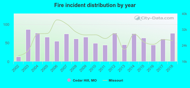 Based on the data from the years 2002 - 2018 the average number of fires per year is 61. The highest number of reported fire incidents - 86 took place in 2003, and the least - 13 in 2002. The data has a growing trend.
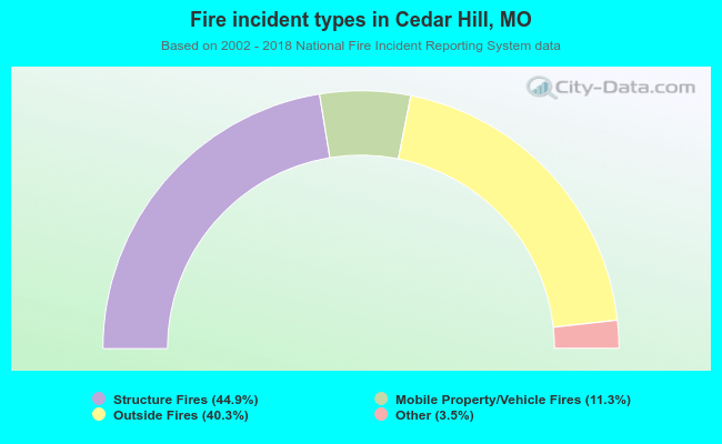 When looking into fire subcategories, the most reports belonged to: Structure Fires (44.9%), and Outside Fires (40.3%).
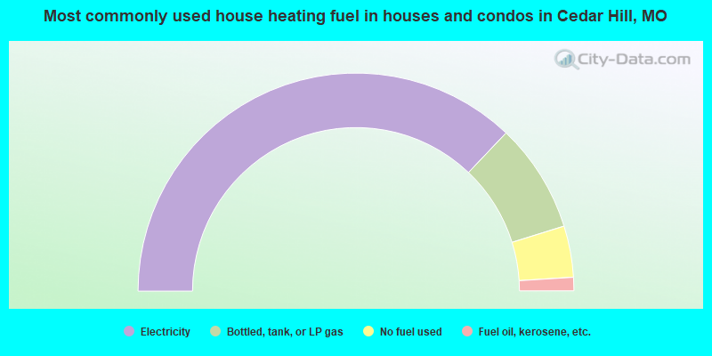
- 74.2%Electricity
- 16.2%Bottled, tank, or LP gas
- 7.6%No fuel used
- 2.0%Fuel oil, kerosene, etc.
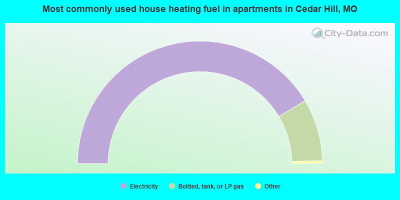
- 83.5%Electricity
- 16.5%Bottled, tank, or LP gas
Cedar Hill compared to Missouri state average:
- Black race population percentage significantly below state average.
- Hispanic race population percentage below state average.
- Foreign-born population percentage significantly below state average.
- Renting percentage below state average.
- Number of college students significantly below state average.
Cedar Hill on our top lists:
- #68 on the list of "Top 101 cities with the most cars per house, population 500+"
- #35 on the list of "Top 101 counties with the lowest percentage of residents relocating from foreign countries between 2010 and 2011"
- #53 on the list of "Top 101 counties with the largest increase in the number of deaths per 1000 residents 2000-2006 to 2007-2013 (pop. 50,000+)"
- #63 on the list of "Top 101 counties with the lowest percentage of residents relocating to foreign countries in 2011"
- #73 on the list of "Top 101 counties with the lowest surface withdrawal of fresh water for public supply (pop. 50,000+)"
- #74 on the list of "Top 101 counties with the highest Ozone (1-hour) air pollution readings in 2012 (ppm)"

|
|
Total of 12 patent applications in 2008-2024.