Dahlonega, Georgia

Dahlonega: Chestatee Regional Hospital Dahlonega
Dahlonega: Dahlonega's Gold Museum in the Town Square - Xmas 2007
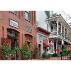
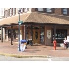
Dahlonega: Arts, crafts, and sweets shops in Dahlonega's Town Square
Dahlonega: Arts and crafts shops in Dahlonega's Town Square

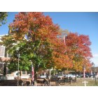
Dahlonega: Quiet Dahlonega street
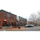
Dahlonega: Arts and crafts shops in Dahlonega's Town Square - wider view
Dahlonega: NGU Campus
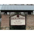
Dahlonega: Welcome to Dahlonega

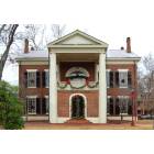
Dahlonega: Enterence to North Georgia University & College
Dahlonega: The Fudge Factory on the Square
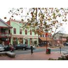
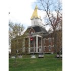
Dahlonega: Town Center Dahlonega Georgia
- see
16
more - add
your
Submit your own pictures of this city and show them to the world
- OSM Map
- General Map
- Google Map
- MSN Map
Population change since 2000: +105.1%
| Males: 3,335 | |
| Females: 4,126 |
| Median resident age: | 22.0 years |
| Georgia median age: | 37.6 years |
Zip codes: 30533.
| Dahlonega: | $59,144 |
| GA: | $72,837 |
Estimated per capita income in 2022: $25,107 (it was $16,572 in 2000)
Dahlonega city income, earnings, and wages data
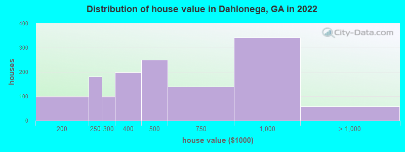
Estimated median house or condo value in 2022: $474,824 (it was $164,500 in 2000)
| Dahlonega: | $474,824 |
| GA: | $297,400 |
Mean prices in 2022: all housing units: $543,200; detached houses: $549,627; townhouses or other attached units: $454,580
Median gross rent in 2022: $1,227.
(30.2% for White Non-Hispanic residents, 23.0% for Hispanic or Latino residents, 65.3% for two or more races residents)
Detailed information about poverty and poor residents in Dahlonega, GA


Compare current foreclosures in Dahlonega, GA:
| Photo | Address | Area | Beds / Baths | Price | Details |
|---|---|---|---|---|---|

|
#1
Merlin Dr
Dahlonega, GA 30533
|
1,216 sq. feet
|
2 baths 2 beds |
show details | |

|
#2
Venetian Cir
Dahlonega, GA 30533
|
960 sq. feet
|
2 baths 3 beds |
show details | |

|
#3
Mountain Pointe Dr
Dahlonega, GA 30533
|
1,456 sq. feet
|
2 baths 2 beds |
show details | |

|
#4
Pink Williams Rd
Dahlonega, GA 30533
|
1,620 sq. feet
|
2 baths 3 beds |
show details | |

|
#5
Shenandoah Dr
Dahlonega, GA 30533
|
2,052 sq. feet
|
2 baths 3 beds |
show details | |

|
#6
Angels Way
Dahlonega, GA 30533
|
2,380 sq. feet
|
2 baths - beds |
show details | |

|
#7
Hunters Run
Dahlonega, GA 30533
|
1,400 sq. feet
|
2 baths - beds |
show details | |

|
#8
Emeley Dr
Dahlonega, GA 30533
|
1,152 sq. feet
|
2 baths - beds |
show details | |

|
#9
Anderson Dr
Dahlonega, GA 30533
|
1,776 sq. feet
|
2 baths - beds |
show details | |

|
#10
High Creek Dr
Dahlonega, GA 30533
|
2,894 sq. feet
|
3 baths - beds |
show details |
| Photo | Address | Area | Beds / Baths | Price | Details |
|---|---|---|---|---|---|

|
#11
Bridgestone Way
Dahlonega, GA 30533
|
2,437 sq. feet
|
2 baths - beds |
show details | |

|
#12
Lakeview Dr
Dahlonega, GA 30533
|
2,840 sq. feet
|
3 baths - beds |
show details | |

|
#13
Valley Run
Dahlonega, GA 30533
|
1,470 sq. feet
|
2 baths - beds |
show details | |

|
#14
Sarah Ann Ln
Dahlonega, GA 30533
|
1,268 sq. feet
|
2 baths - beds |
show details | |

|
#15
Walkabout Way
Dahlonega, GA 30533
|
1,365 sq. feet
|
2 baths - beds |
show details | |

|
#16
Deerfield Dr
Dahlonega, GA 30533
|
1,205 sq. feet
|
2 baths - beds |
show details | |

|
#17
Old Ellijay Rd E
Dahlonega, GA 30533
|
720 sq. feet
|
2 baths - beds |
show details | |

|
#18
Cardinal Dr
Dahlonega, GA 30533
|
624 sq. feet
|
2 baths - beds |
show details | |

|
#19
Angers Ct
Dahlonega, GA 30533
|
910 sq. feet
|
2 baths - beds |
show details | |

|
#20
Hester Rd
Dahlonega, GA 30533
|
2,016 sq. feet
|
- baths - beds |
show details |
| Photo | Address | Area | Beds / Baths | Price | Details |
|---|---|---|---|---|---|

|
#21
River Trace Dr
Dahlonega, GA 30533
|
- sq. feet
|
- baths - beds |
show details | |

|
#22
Baker St
Dahlonega, GA 30533
|
- sq. feet
|
- baths - beds |
show details | |

|
#23
Norris Rd
Dahlonega, GA 30533
|
- sq. feet
|
- baths - beds |
show details | |

|
#24
Collins Way
Dahlonega, GA 30533
|
- sq. feet
|
- baths - beds |
show details | |

|
#25
Long Branch Xing
Dahlonega, GA 30533
|
- sq. feet
|
- baths - beds |
show details | |

|
#26
Salisbury Rd
Dahlonega, GA 30533
|
- sq. feet
|
- baths - beds |
show details | |

|
#27
Green Acre Rd
Dahlonega, GA 30533
|
- sq. feet
|
- baths - beds |
show details | |

|
#28
Mountain View Trl E Apt 22
Dahlonega, GA 30533
|
- sq. feet
|
- baths - beds |
show details | |

|
#29
Highway 42 W
Dahlonega, GA 30533
|
- sq. feet
|
- baths - beds |
show details | |

|
#30
Venetian Cir
Dahlonega, GA 30533
|
- sq. feet
|
- baths - beds |
show details |
| Photo | Address | Area | Beds / Baths | Price | Details |
|---|---|---|---|---|---|

|
Check over 1 million property listings on Foreclosure.com!
|
browse all offers | |||
| Photo | Address | Area | Beds / Baths | Price | Details |
|---|


- 6,06984.2%White alone
- 4706.5%Hispanic
- 2924.1%Black alone
- 2393.3%Two or more races
- 370.5%American Indian alone
- 320.4%Asian alone
Races in Dahlonega detailed stats: ancestries, foreign born residents, place of birth
According to our research of Georgia and other state lists, there were 65 registered sex offenders living in Dahlonega, Georgia as of April 27, 2024.
The ratio of all residents to sex offenders in Dahlonega is 97 to 1.
 Recent articles from our blog. Our writers, many of them Ph.D. graduates or candidates, create easy-to-read articles on a wide variety of topics.

 | Dahlonega Georgia vs Douglasville area (11 replies) |
| Is there any affordable housing in the Gainesville/Dahlonega area? (3 replies) |
| Newnan or Dahlonega for Young Couple & Mom (5 replies) |
| Trash on roadways in the Dahlonega and Dawsonville area (2 replies) |
| Christmas Holiday Season in Atlanta (137 replies) |
| Best North Georgia mountain town? (37 replies) |
Latest news from Dahlonega, GA collected exclusively by city-data.com from local newspapers, TV, and radio stations
Ancestries: American (22.7%), English (8.6%), Italian (6.9%), Irish (6.6%), German (6.0%), Scotch-Irish (4.7%).
Current Local Time: EST time zone
Elevation: 1454 feet
Land area: 6.40 square miles.
Population density: 1,165 people per square mile (low).
553 residents are foreign born (3.9% Latin America, 3.3% Europe).
| This city: | 7.7% |
| Georgia: | 10.4% |
Median real estate property taxes paid for housing units with mortgages in 2022: $3,001 (0.7%)
Median real estate property taxes paid for housing units with no mortgage in 2022: $3,334 (0.6%)
Nearest city with pop. 50,000+: Johns Creek, GA (36.6 miles  , pop. 76,728).
Nearest city with pop. 200,000+: Atlanta, GA (58.5 miles , pop. 416,474).
Nearest city with pop. 1,000,000+: Chicago, IL (543.9 miles , pop. 2,896,016).
Nearest cities:
), ), ), ), )Latitude: 34.53 N, Longitude: 83.98 W
Daytime population change due to commuting: +3,608 (+50.0%)
Workers who live and work in this city: 1,595 (54.8%)
Area code: 706

Dahlonega tourist attractions:
Dahlonega, Georgia accommodation & food services, waste management - Economy and Business Data
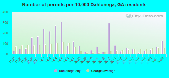
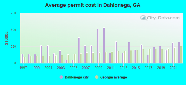
Single-family new house construction building permits:
- 2022: 47 buildings, average cost: $320,300
- 2021: 24 buildings, average cost: $310,400
- 2020: 16 buildings, average cost: $195,000
- 2019: 11 buildings, average cost: $256,500
- 2018: 6 buildings, average cost: $240,000
- 2017: 17 buildings, average cost: $126,300
- 2016: 22 buildings, average cost: $278,500
- 2015: 10 buildings, average cost: $205,000
- 2014: 31 buildings, average cost: $315,800
- 2013: 107 buildings, average cost: $158,200
- 2012: 7 buildings, average cost: $327,900
- 2011: 25 buildings, average cost: $156,000
- 2010: 13 buildings, average cost: $531,800
- 2009: 7 buildings, average cost: $515,000
- 2008: 29 buildings, average cost: $267,600
- 2007: 44 buildings, average cost: $267,600
- 2006: 29 buildings, average cost: $386,200
- 2005: 111 buildings, average cost: $46,200
- 2004: 99 buildings, average cost: $46,200
- 2003: 79 buildings, average cost: $188,800
- 2002: 87 buildings, average cost: $150,400
- 2001: 61 buildings, average cost: $268,900
- 2000: 58 buildings, average cost: $268,900
- 1999: 20 buildings, average cost: $136,300
- 1998: 19 buildings, average cost: $136,300
- 1997: 11 buildings, average cost: $136,900
| Here: | 2.1% |
| Georgia: | 2.9% |
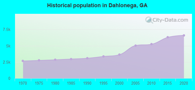
Population change in the 1990s: +407 (+12.6%).
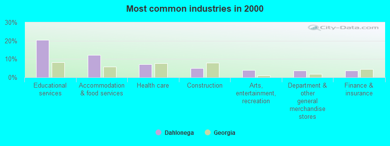
- Educational services (20.4%)
- Accommodation & food services (12.1%)
- Health care (7.2%)
- Construction (4.9%)
- Arts, entertainment, recreation (3.9%)
- Department & other general merchandise stores (3.7%)
- Finance & insurance (3.6%)
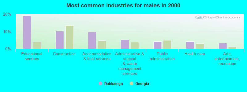
- Educational services (19.3%)
- Construction (10.2%)
- Accommodation & food services (9.8%)
- Administrative & support & waste management services (5.4%)
- Public administration (4.2%)
- Health care (4.2%)
- Arts, entertainment, recreation (3.4%)
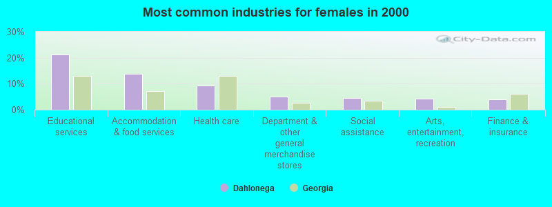
- Educational services (21.2%)
- Accommodation & food services (13.8%)
- Health care (9.4%)
- Department & other general merchandise stores (5.1%)
- Social assistance (4.5%)
- Arts, entertainment, recreation (4.3%)
- Finance & insurance (4.1%)
- Retail sales workers, except cashiers (6.8%)
- Other office and administrative support workers, including supervisors (6.5%)
- Cashiers (5.4%)
- Postsecondary teachers (5.0%)
- Supervisors and other personal care and service workers, except child care workers (4.9%)
- Waiters and waitresses (4.4%)
- Building and grounds cleaning and maintenance occupations (3.8%)
- Postsecondary teachers (7.4%)
- Other office and administrative support workers, including supervisors (6.7%)
- Retail sales workers, except cashiers (5.4%)
- Supervisors and other personal care and service workers, except child care workers (5.1%)
- Building and grounds cleaning and maintenance occupations (4.5%)
- Other production occupations, including supervisors (3.8%)
- Other health diagnosing and treating practitioners and technical occupations (3.5%)
- Cashiers (8.5%)
- Retail sales workers, except cashiers (7.9%)
- Other office and administrative support workers, including supervisors (6.5%)
- Waiters and waitresses (5.8%)
- Supervisors and other personal care and service workers, except child care workers (4.8%)
- Information and record clerks, except customer service representatives (4.7%)
- Preschool, kindergarten, elementary, and middle school teachers (4.6%)
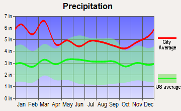
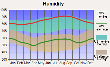
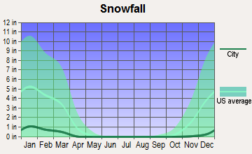
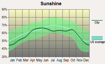
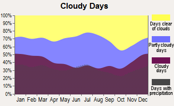
Average climate in Dahlonega, Georgia
Based on data reported by over 4,000 weather stations

(lower is better)
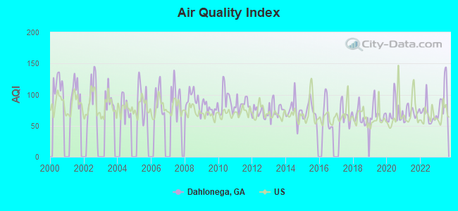
Air Quality Index (AQI) level in 2023 was 93.0. This is worse than average.
| City: | 93.0 |
| U.S.: | 72.6 |
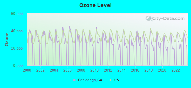
Ozone [ppb] level in 2022 was 27.0. This is better than average. Closest monitor was 11.5 miles away from the city center.
| City: | 27.0 |
| U.S.: | 33.3 |
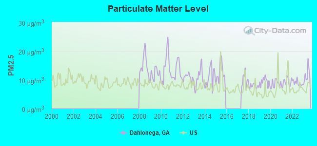
Particulate Matter (PM2.5) [µg/m3] level in 2023 was 11.5. This is significantly worse than average. Closest monitor was 18.7 miles away from the city center.
| City: | 11.5 |
| U.S.: | 8.1 |
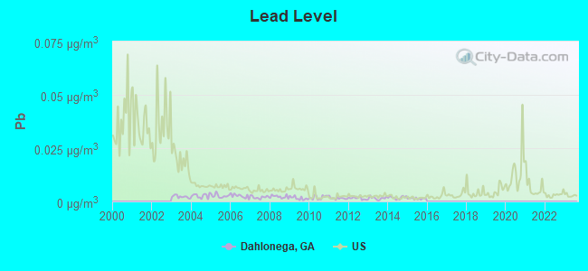
Lead (Pb) [µg/m3] level in 2015 was 0.00139. This is significantly better than average. Closest monitor was 11.5 miles away from the city center.
| City: | 0.00139 |
| U.S.: | 0.00931 |
Tornado activity:
Dahlonega-area historical tornado activity is near Georgia state average. It is 37% greater than the overall U.S. average.
On 4/3/1974, a category F4 (max. wind speeds 207-260 mph) tornado 7.7 miles away from the Dahlonega city center killed 6 people and injured 30 people and caused between $500,000 and $5,000,000 in damages.
On 3/27/1994, a category F4 tornado 19.3 miles away from the city center killed 3 people and injured 20 people and caused between $5,000,000 and $50,000,000 in damages.
Earthquake activity:
Dahlonega-area historical earthquake activity is significantly above Georgia state average. It is 59% greater than the overall U.S. average.On 4/29/2003 at 08:59:39, a magnitude 4.9 (4.4 MB, 4.6 MW, 4.9 LG, Class: Light, Intensity: IV - V) earthquake occurred 93.7 miles away from the city center
On 8/2/1974 at 08:52:09, a magnitude 4.9 (4.3 MB, 4.9 LG) earthquake occurred 97.0 miles away from Dahlonega center
On 11/30/1973 at 07:48:41, a magnitude 4.7 (4.7 MB, 4.6 ML) earthquake occurred 87.8 miles away from the city center
On 4/29/2003 at 08:59:39, a magnitude 4.6 (4.6 MW, Depth: 12.3 mi) earthquake occurred 93.8 miles away from Dahlonega center
On 8/9/2020 at 12:07:37, a magnitude 5.1 (5.1 MW, Depth: 4.7 mi, Class: Moderate, Intensity: VI - VII) earthquake occurred 211.2 miles away from the city center
On 12/12/2018 at 09:14:43, a magnitude 4.4 (4.4 MW, Depth: 4.9 mi) earthquake occurred 86.0 miles away from Dahlonega center
Magnitude types: regional Lg-wave magnitude (LG), body-wave magnitude (MB), local magnitude (ML), moment magnitude (MW)
Natural disasters:
The number of natural disasters in Lumpkin County (15) is near the US average (15).Major Disasters (Presidential) Declared: 10
Emergencies Declared: 4
Causes of natural disasters: Tornadoes: 5, Floods: 4, Storms: 4, Winter Storms: 4, Hurricanes: 3, Winds: 2, Drought: 1, Heavy Rain: 1, Snowfall: 1, Other: 1 (Note: some incidents may be assigned to more than one category).

Hospitals and medical centers in Dahlonega:
Airports and heliports located in Dahlonega:
- Lumpkin County-Wimpys Airport (9A0) (Runways: 1, Itinerant Ops: 2,000, Local Ops: 3,000, Military Ops: 600)
- Mosby Ahp Heliport (7A7)
Colleges/Universities in Dahlonega:
Other colleges/universities with over 2000 students near Dahlonega:
- Brenau University (about 19 miles; Gainesville, GA; Full-time enrollment: 2,341)
- Lanier Technical College (about 22 miles; Oakwood, GA; FT enrollment: 2,435)
- Piedmont College (about 26 miles; Demorest, GA; FT enrollment: 2,251)
- Georgia Gwinnett College (about 39 miles; Lawrenceville, GA; FT enrollment: 7,993)
- Gwinnett Technical College (about 40 miles; Lawrenceville, GA; FT enrollment: 5,138)
- The Art Institute of Atlanta (about 47 miles; Atlanta, GA; FT enrollment: 3,140)
- Kennesaw State University (about 49 miles; Kennesaw, GA; FT enrollment: 21,215)
Public high school in Dahlonega:
- LUMPKIN COUNTY HIGH SCHOOL (Students: 1,051, Location: 2001 INDIAN DR, Grades: 9-12)
Public elementary/middle schools in Dahlonega:
- LUMPKIN COUNTY MIDDLE SCHOOL (Students: 887, Location: 152 SCHOOL DR, Grades: 6-8)
- LUMPKIN COUNTY ELEMENTARY SCHOOL (Students: 619, Location: 153 SCHOOL DR, Grades: PK-5)
- LONG BRANCH ELEMENTARY SCHOOL (Students: 502, Location: 4518 HIGHWAY 52 E, Grades: PK-5)
Points of interest:
Notable locations in Dahlonega: Dahlonega - Lumpkin County Volunteer Fire Department Station 1 (A), Chestatee Ranger District Office (B), Lumpkin County Library (C), Lumpkin County Courthouse (D), Gold Museum (E), Dahlonega City Hall (F). Display/hide their locations on the map
Churches in Dahlonega include: Dahlonega Methodist Church (A), Dahlonega Baptist Church (B). Display/hide their locations on the map
Cemetery: Mount Hope Cemetery (1). Display/hide its location on the map
Creek: Yahoola Creek (A). Display/hide its location on the map
Tourist attractions: Lumpkin County Schools (Cultural Attractions- Events- & Facilities; Courthouse Hill), Chestatee Wild Life Preserve (Cultural Attractions- Events- & Facilities; 469 Old Dahlonega Highway), Chattahoochee Backcountry Treks (Tours & Charters; 1353 Chester Road), Gold Miners Camp (Tours & Charters; Highway 60 South), Consolidated Gold Mine (Tours & Charters; 185 Consolidated Gold Mi).
Hotels: Days Inn Dahlonega (1065 Chestatee Street), Econo Lodge (619 Grove Street North # A), Econo Lodge Dahlonega (619A North Grove Street), Dahlonega-Days Inn (Hwy 19 And Hwy 60) (833 S Chestatee St).
Birthplace of: Sara Christian - Racing driver, Tyrece Legette - College basketball player (Alabama State Hornets).
Drinking water stations with addresses in Dahlonega that have no violations reported:
- DAHLONEGA (Population served: 4,120, Primary Water Source Type: Surface water)
- CANE CREEK TRAILER PARK (Population served: 70, Primary Water Source Type: Groundwater)
| This city: | 2.3 people |
| Georgia: | 2.6 people |
| This city: | 52.6% |
| Whole state: | 68.5% |
| This city: | 3.5% |
| Whole state: | 5.9% |
Likely homosexual households (counted as self-reported same-sex unmarried-partner households)
- Lesbian couples: 0.2% of all households
- Gay men: 0.0% of all households
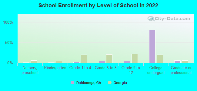
People in group quarters in Dahlonega in 2010:
- 1,466 people in college/university student housing
- 120 people in local jails and other municipal confinement facilities
- 93 people in nursing facilities/skilled-nursing facilities
- 6 people in other noninstitutional facilities
- 4 people in group homes for juveniles (non-correctional)
People in group quarters in Dahlonega in 2000:
- 1,035 people in college dormitories (includes college quarters off campus)
- 98 people in nursing homes
- 60 people in local jails and other confinement facilities (including police lockups)
Banks with branches in Dahlonega (2011 data):
- Branch Banking and Trust Company: Dahlonega Main Branch at 60 West Main Street, branch established on 2001/11/13; Memorial Drive Branch at 148 Memorial Drive, branch established on 1989/09/25. Info updated 2010/03/29: Bank assets: $168,867.6 mil, Deposits: $127,549.5 mil, headquarters in Winston Salem, NC, positive income, Commercial Lending Specialization, 1793 total offices, Holding Company: Bb&T Corporation
- United Community Bank: Lumpkin Branch at 104 Memorial Drive, branch established on 1996/07/01; Of Lumpkin Co at 206 Morrison Moore Parkway, branch established on 1996/07/01. Info updated 2009/06/23: Bank assets: $6,977.4 mil, Deposits: $6,170.1 mil, headquarters in Blairsville, GA, negative income in the last year, Commercial Lending Specialization, 106 total offices, Holding Company: United Community Banks, Inc.
- SunTrust Bank: Highway 60 Branch at 5458 South Chestatee Street, branch established on 1997/02/10; Lumpkin County Bank Branch at 111 South Chestatee Street, branch established on 1982/12/14. Info updated 2010/05/27: Bank assets: $171,291.7 mil, Deposits: $129,833.2 mil, headquarters in Atlanta, GA, positive income, Commercial Lending Specialization, 1716 total offices, Holding Company: Suntrust Banks, Inc.
- Community & Southern Bank: Dahlonega Branch at 53 Mechanicsville Road, branch established on 2007/06/01. Info updated 2010/09/20: Bank assets: $2,188.5 mil, Deposits: $1,690.2 mil, headquarters in Carrollton, GA, positive income, Commercial Lending Specialization, 39 total offices, Holding Company: Community & Southern Holdings, Inc.
- Regions Bank: Dahlonega Branch at 19 Choice Street, branch established on 2001/01/08. Info updated 2011/02/24: Bank assets: $123,368.2 mil, Deposits: $98,301.3 mil, headquarters in Birmingham, AL, positive income, Commercial Lending Specialization, 1778 total offices, Holding Company: Regions Financial Corporation
- Wells Fargo Bank, National Association: Dahlonega Branch at 312 East Main Street, branch established on 1990/06/27. Info updated 2011/04/05: Bank assets: $1,161,490.0 mil, Deposits: $905,653.0 mil, headquarters in Sioux Falls, SD, positive income, 6395 total offices, Holding Company: Wells Fargo & Company
For population 15 years and over in Dahlonega:
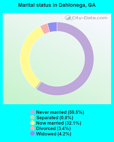
- Never married: 59.5%
- Now married: 32.1%
- Separated: 0.8%
- Widowed: 4.2%
- Divorced: 3.4%
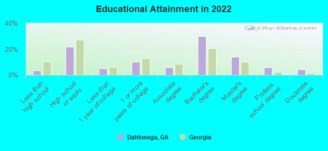
For population 25 years and over in Dahlonega:
- High school or higher: 95.8%
- Bachelor's degree or higher: 52.7%
- Graduate or professional degree: 22.8%
- Unemployed: 3.8%
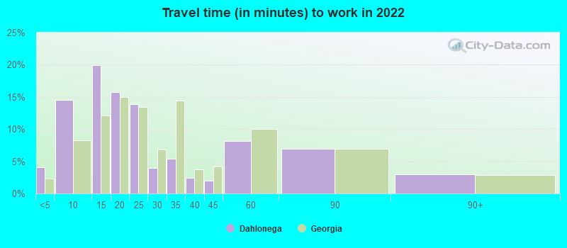
- Mean travel time to work (commute): 23.1 minutes
| Here: | 10.3 |
| Georgia average: | 12.2 |
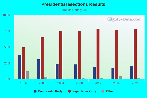
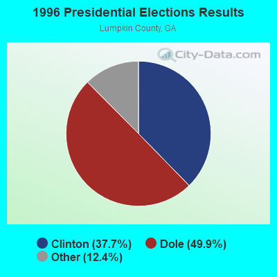
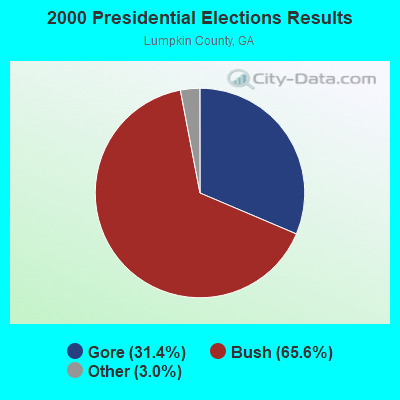

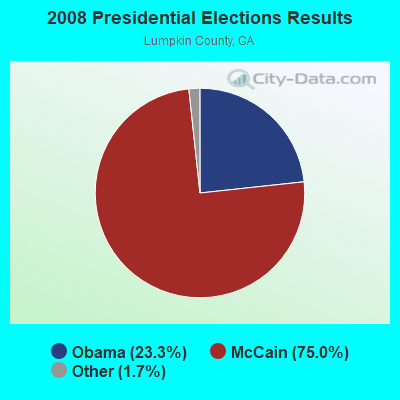
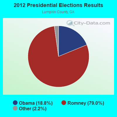
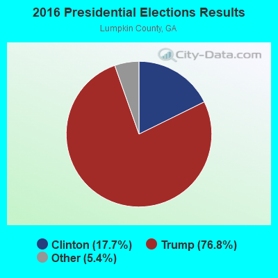
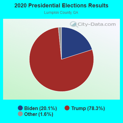
Graphs represent county-level data. Detailed 2008 Election Results
Religion statistics for Dahlonega, GA (based on Lumpkin County data)
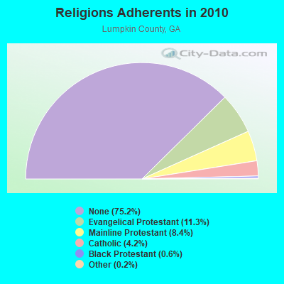
| Religion | Adherents | Congregations |
|---|---|---|
| Evangelical Protestant | 3,386 | 17 |
| Mainline Protestant | 2,532 | 6 |
| Catholic | 1,254 | 1 |
| Black Protestant | 179 | 1 |
| Other | 73 | 2 |
| None | 22,542 | - |
Food Environment Statistics:
| Lumpkin County: | 0.75 / 10,000 pop. |
| Georgia: | 1.91 / 10,000 pop. |
| Here: | 0.38 / 10,000 pop. |
| State: | 0.15 / 10,000 pop. |
| Here: | 0.75 / 10,000 pop. |
| State: | 0.86 / 10,000 pop. |
| Lumpkin County: | 5.66 / 10,000 pop. |
| Georgia: | 5.12 / 10,000 pop. |
| Lumpkin County: | 7.17 / 10,000 pop. |
| Georgia: | 7.41 / 10,000 pop. |
| Lumpkin County: | 9.1% |
| State: | 10.4% |
| Lumpkin County: | 26.6% |
| State: | 27.8% |
| This county: | 12.9% |
| State: | 14.6% |
Health and Nutrition:
| Dahlonega: | 49.3% |
| State: | 48.9% |
| This city: | 48.0% |
| Georgia: | 46.5% |
| Dahlonega: | 27.5 |
| Georgia: | 28.9 |
| This city: | 18.1% |
| State: | 20.4% |
| Dahlonega: | 9.1% |
| Georgia: | 10.8% |
| This city: | 6.9 |
| State: | 6.7 |
| Here: | 30.5% |
| Georgia: | 33.5% |
| Dahlonega: | 58.6% |
| Georgia: | 56.2% |
| Dahlonega: | 81.2% |
| Georgia: | 80.8% |
More about Health and Nutrition of Dahlonega, GA Residents
| Local government employment and payroll (March 2022) | |||||
| Function | Full-time employees | Monthly full-time payroll | Average yearly full-time wage | Part-time employees | Monthly part-time payroll |
|---|---|---|---|---|---|
| Streets and Highways | 12 | $50,095 | $50,095 | 5 | $11,232 |
| Water Supply | 10 | $40,582 | $48,698 | 2 | $1,159 |
| Solid Waste Management | 8 | $24,147 | $36,221 | 0 | $0 |
| Financial Administration | 6 | $29,114 | $58,228 | 0 | $0 |
| Other and Unallocable | 5 | $19,911 | $47,786 | 9 | $10,130 |
| Other Government Administration | 5 | $30,882 | $74,117 | 11 | $5,276 |
| Sewerage | 4 | $17,085 | $51,255 | 1 | $426 |
| Police Protection - Officers | 3 | $15,907 | $63,628 | 1 | $628 |
| Parks and Recreation | 0 | $0 | 1 | $1,536 | |
| Judicial and Legal | 0 | $0 | 2 | $1,029 | |
| Totals for Government | 53 | $227,723 | $51,560 | 32 | $31,417 |
Dahlonega government finances - Expenditure in 2017 (per resident):
- Construction - Regular Highways: $123,000 ($16.49)
- Current Operations - Water Utilities: $2,309,000 ($309.48)
Sewerage: $1,682,000 ($225.44)
Central Staff Services: $1,349,000 ($180.81)
Regular Highways: $1,026,000 ($137.52)
Solid Waste Management: $754,000 ($101.06)
General - Other: $532,000 ($71.30)
Judicial and Legal Services: $186,000 ($24.93)
Housing and Community Development: $181,000 ($24.26)
Miscellaneous Commercial Activities - Other: $55,000 ($7.37)
Police Protection: $47,000 ($6.30)
Parks and Recreation: $25,000 ($3.35)
Local Fire Protection: $1,000 ($0.13)
- General - Interest on Debt: $1,678,000 ($224.90)
- Intergovernmental to Local - Other - General - Other: $182,000 ($24.39)
- Other Capital Outlay - Central Staff Services: $17,000 ($2.28)
Parks and Recreation: $7,000 ($0.94)
Regular Highways: $1,000 ($0.13)
- Total Salaries and Wages: $92,000 ($12.33)
- Water Utilities - Interest on Debt: $700,000 ($93.82)
Dahlonega government finances - Revenue in 2017 (per resident):
- Charges - Sewerage: $3,182,000 ($426.48)
Solid Waste Management: $698,000 ($93.55)
Other: $35,000 ($4.69)
- Federal Intergovernmental - General Local Government Support: $20,000 ($2.68)
- Local Intergovernmental - General Local Government Support: $785,000 ($105.21)
Other: $679,000 ($91.01)
- Miscellaneous - Fines and Forfeits: $93,000 ($12.46)
Sale of Property: $45,000 ($6.03)
General Revenue - Other: $30,000 ($4.02)
Interest Earnings: $26,000 ($3.48)
Rents: $6,000 ($0.80)
Donations From Private Sources: $1,000 ($0.13)
- Revenue - Water Utilities: $1,692,000 ($226.78)
- State Intergovernmental - Other: $17,000 ($2.28)
General Local Government Support: $5,000 ($0.67)
- Tax - Property: $1,221,000 ($163.65)
Public Utilities Sales: $542,000 ($72.64)
Insurance Premiums Sales: $302,000 ($40.48)
Other Selective Sales: $227,000 ($30.42)
Alcoholic Beverage Sales: $198,000 ($26.54)
Alcoholic Beverage License: $104,000 ($13.94)
Occupation and Business License - Other: $89,000 ($11.93)
Other: $39,000 ($5.23)
Other License: $37,000 ($4.96)
Dahlonega government finances - Debt in 2017 (per resident):
- Long Term Debt - Beginning Outstanding - Unspecified Public Purpose: $32,397,000 ($4342.18)
Outstanding Unspecified Public Purpose: $31,587,000 ($4233.61)
Retired Unspecified Public Purpose: $810,000 ($108.56)
Dahlonega government finances - Cash and Securities in 2017 (per resident):
- Other Funds - Cash and Securities: $7,738,000 ($1037.13)
- Sinking Funds - Cash and Securities: $135,000 ($18.09)
| Businesses in Dahlonega, GA | ||||
| Name | Count | Name | Count | |
|---|---|---|---|---|
| AT&T | 1 | La-Z-Boy | 1 | |
| Ace Hardware | 1 | Little Caesars Pizza | 1 | |
| Advance Auto Parts | 1 | McDonald's | 1 | |
| AutoZone | 1 | Papa John's Pizza | 1 | |
| Chick-Fil-A | 1 | Pizza Hut | 1 | |
| Dairy Queen | 1 | RadioShack | 1 | |
| Days Inn | 1 | Rite Aid | 1 | |
| Domino's Pizza | 1 | Sears | 1 | |
| Econo Lodge | 1 | Subway | 1 | |
| FedEx | 2 | Super 8 | 1 | |
| Ford | 1 | Taco Bell | 1 | |
| GNC | 1 | U-Haul | 1 | |
| H&R Block | 1 | UPS | 3 | |
| Holiday Inn | 1 | Waffle House | 1 | |
| Home Depot | 1 | Walmart | 1 | |
| Jones New York | 1 | Wendy's | 1 | |
Strongest AM radio stations in Dahlonega:
- WDGR (1210 AM; daytime; 10 kW; DAHLONEGA, GA; Owner: SMALL TOWN RADIO OF GEORGIA, INC.)
- WDUN (550 AM; 10 kW; GAINESVILLE, GA; Owner: JWJ PROPERTIRS, INC.)
- WCNN (680 AM; 50 kW; NORTH ATLANTA, GA; Owner: DICKEY BROADCASTING COMPANY)
- WSB (750 AM; 50 kW; ATLANTA, GA; Owner: CXR HOLDINGS, INC.)
- WGST (640 AM; 50 kW; ATLANTA, GA; Owner: CITICASTERS LICENSES, L.P.)
- WLBA (1130 AM; daytime; 10 kW; GAINESVILLE, GA)
- WFTD (1080 AM; daytime; 50 kW; MARIETTA, GA; Owner: PRIETO ENTERPRISES, INC.)
- WGUN (1010 AM; 50 kW; ATLANTA, GA; Owner: WGUN, INC.)
- WMLB (1160 AM; 50 kW; EAST POINT, GA; Owner: ATLANTA AREA BROADCASTING, INC.)
- WQXI (790 AM; 28 kW; ATLANTA, GA; Owner: JEFFERSON-PILOT COMMUNICATIONS COMPANY OF GEORGIA)
- WAZX (1550 AM; 50 kW; SMYRNA, GA; Owner: GA-MEX BROADCASTING, INC.)
- WAOK (1380 AM; 50 kW; ATLANTA, GA; Owner: INFINITY BROADCASTING OPERATIONS, INC.)
- WLFJ (660 AM; daytime; 50 kW; GREENVILLE, SC; Owner: CLEAR CHANNEL BROADCASTING LICENSES, INC.)
Strongest FM radio stations in Dahlonega:
- WNGU (89.5 FM; DAHLONEGA, GA; Owner: GEORGIA PUBLIC TELECOMMUNICATIONS COMMISSION)
- WKHC (104.3 FM; DAHLONEGA, GA; Owner: WILLIAMS COMMUNICATIONS, INC.)
- WNGC (106.1 FM; TOCCOA, GA; Owner: SOUTHERN BROADCASTING OF PENSACOLA, INC)
- WCON-FM (99.3 FM; CORNELIA, GA; Owner: HABERSHAM BROADCASTING CO.)
- WFOX (97.1 FM; GAINESVILLE, GA; Owner: COX RADIO, INC.)
- WYAY (106.7 FM; GAINESVILLE, GA; Owner: ABC, INC.)
- WWEV-FM (91.5 FM; CUMMING, GA; Owner: CURRICULUM DEVELOPMENT FOUNDATION)
- WPPR (88.3 FM; DEMOREST, GA; Owner: GEORGIA PUBLIC TELECOMMUNICATIONS COMMISSION)
- WFQS (91.3 FM; FRANKLIN, NC; Owner: WESTERN NORTH CAROLINA PUBLIC RADIO)
- WHEL (105.1 FM; HELEN, GA; Owner: CITICASTERS LICENSES, L.P.)
- WBCX (89.1 FM; GAINESVILLE, GA; Owner: BRENAU COLLEGE)
- WCVP-FM (95.9 FM; ROBBINSVILLE, NC; Owner: CHEROKEE BROADCASTING COMPANY, INC.)
- W234AG (94.7 FM; CHATSWORTH, GA; Owner: IMMANUEL BROADCASTING NETWORK, INC.)
- W221AW (92.1 FM; NORTH CANTON, GA; Owner: IMMANUEL BROADCASTING NETWORK, INC.)
- WTFH (89.9 FM; HELEN, GA; Owner: TOCCOA FALLS COLLEGE)
- W214AS (90.7 FM; WALESKA, GA; Owner: CALVARY CHAPEL OF TWIN FALLS, INC.)
- WFSH-FM (104.7 FM; ATHENS, GA; Owner: SOUTH TEXAS BROADCASTING, INC.)
- WRBN (104.1 FM; CLAYTON, GA; Owner: SUTTON RADIOCASTING CORPORATION)
- WBTS (95.5 FM; ATHENS, GA; Owner: CXR HOLDINGS, INC.)
- WAZX-FM (101.9 FM; CLEVELAND, GA; Owner: WAZX-FM, INC)
TV broadcast stations around Dahlonega:
- W50AB (Channel 50; HIAWASSEE, GA; Owner: GEORGIA PUBLIC TELECOMMUNICATIONS COMMISSION)
- WUVG (Channel 34; ATHENS, GA; Owner: UNIVISION ATLANTA LLC)
- WSKC-LP (Channel 59; ATLANTA, GA; Owner: KM LPTV OF ATLANTA, L.L.C.)
- National Bridge Inventory (NBI) Statistics
- 21Number of bridges
- 354ft / 108mTotal length
- $21,382,000Total costs
- 106,650Total average daily traffic
- 2,404Total average daily truck traffic
- 159,975Total future (year 2032) average daily traffic
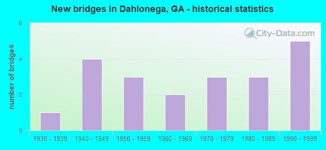
- New bridges - historical statistics
- 11930-1939
- 41940-1949
- 31950-1959
- 21960-1969
- 31970-1979
- 31980-1989
- 51990-1999
FCC Registered Antenna Towers: 137 (See the full list of FCC Registered Antenna Towers)
FCC Registered Private Land Mobile Towers: 1 (See the full list of FCC Registered Private Land Mobile Towers in Dahlonega, GA)
FCC Registered Broadcast Land Mobile Towers: 18 (See the full list of FCC Registered Broadcast Land Mobile Towers)
FCC Registered Microwave Towers: 23 (See the full list of FCC Registered Microwave Towers in this town)
FCC Registered Paging Towers: 1 (See the full list of FCC Registered Paging Towers)
FCC Registered Amateur Radio Licenses: 200 (See the full list of FCC Registered Amateur Radio Licenses in Dahlonega)
FAA Registered Aircraft: 42 (See the full list of FAA Registered Aircraft in Dahlonega)
2004 - 2018 National Fire Incident Reporting System (NFIRS) incidents
- Fire incident types reported to NFIRS in Dahlonega, GA
- 79255.6%Outside Fires
- 42730.0%Structure Fires
- 18412.9%Mobile Property/Vehicle Fires
- 211.5%Other
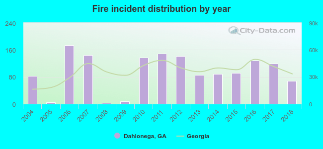 According to the data from the years 2004 - 2018 the average number of fires per year is 95. The highest number of fire incidents - 174 took place in 2006, and the least - 3 in 2008. The data has a decreasing trend.
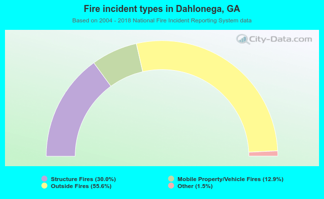 When looking into fire subcategories, the most incidents belonged to: Outside Fires (55.6%), and Structure Fires (30.0%).
| Most common first names in Dahlonega, GA among deceased individuals | ||
| Name | Count | Lived (average) |
|---|---|---|
| James | 202 | 69.8 years |
| John | 160 | 73.1 years |
| William | 156 | 75.3 years |
| Robert | 128 | 73.7 years |
| Mary | 122 | 80.5 years |
| George | 70 | 75.0 years |
| Charles | 68 | 70.6 years |
| Frank | 56 | 77.2 years |
| Bessie | 50 | 78.4 years |
| Fred | 48 | 75.0 years |
| Most common last names in Dahlonega, GA among deceased individuals | ||
| Last name | Count | Lived (average) |
|---|---|---|
| Davis | 130 | 75.7 years |
| Grizzle | 98 | 73.7 years |
| Anderson | 96 | 75.2 years |
| Smith | 80 | 73.6 years |
| Rider | 72 | 73.5 years |
| Walker | 68 | 77.2 years |
| Seabolt | 66 | 75.8 years |
| Jones | 64 | 74.3 years |
| Martin | 62 | 73.7 years |
| Jarrard | 60 | 76.9 years |
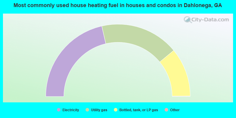
- 42.9%Electricity
- 35.3%Utility gas
- 21.8%Bottled, tank, or LP gas
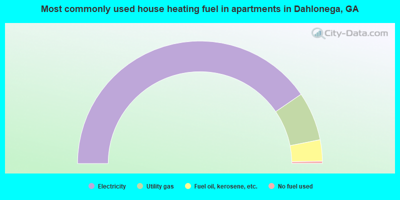
- 80.9%Electricity
- 12.9%Utility gas
- 5.6%Fuel oil, kerosene, etc.
- 0.6%No fuel used
Dahlonega compared to Georgia state average:
- Median house value above state average.
- Unemployed percentage significantly below state average.
- Black race population percentage significantly below state average.
- Median age significantly below state average.
- Renting percentage above state average.
- Length of stay since moving in significantly above state average.
- House age below state average.
- Institutionalized population percentage above state average.
- Number of college students significantly above state average.
- Percentage of population with a bachelor's degree or higher significantly above state average.
Dahlonega on our top lists:
- #7 on the list of "Top 101 cities with largest percentage of females in occupations: sales and related occupations (population 5,000+)"
- #16 on the list of "Top 101 cities with the lowest percentage of single-parent households, population 5,000+"
- #43 on the list of "Top 101 cities with largest percentage of males in occupations: computer and mathematical occupations (population 5,000+)"
- #46 on the list of "Top 101 cities with the smallest percentage of likely homosexual households (counted as self-reported same-sex unmarried-partner households) (population 5,000+)"
- #48 on the list of "Top 100 cities with highest percentage of college students (pop. 5,000+)"
- #52 on the list of "Top 101 cities with largest percentage of females in industries: real estate and rental and leasing (population 5,000+)"
- #62 on the list of "Top 100 cities with youngest residents (pop. 5,000+)"
- #73 on the list of "Top 101 cities with largest percentage of males in occupations: community and social service occupations (population 5,000+)"
- #79 on the list of "Top 101 cities with largest percentage of females in industries: educational services (population 5,000+)"
- #86 on the list of "Top 101 cities with the largest percentage of people in college dormitories (includes college quarters off campus) (population 1,000+)"
- #101 on the list of "Top 101 cities with the least people living the same house as 1 year ago (population 5,000+))"

|
|
Total of 49 patent applications in 2008-2024.