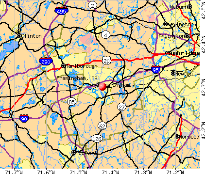
Framingham, Massachusetts

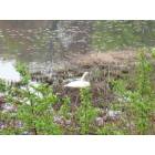
Framingham: Water birds in Farm Pond
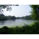
Framingham: Gleason Pond
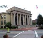
Framingham: Memorial Building - Framingham Town Hall - 150 Concord St.
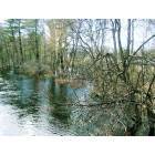
Framingham: Sudbury River at Flood Stage Spring 2007

Framingham: Sudbury Reservoir Number 1
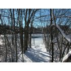
Framingham: Path to Sudbury Reservoir Number 1

Framingham: Sudbury Reservoir Number 1
Framingham: Mother swan on next in Gleason's Pond

Framingham: "The Hunt" October 2008 - Framingham Hunt Club
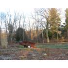
Framingham: Stearns Farm in Spring
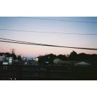
Framingham: rte. 126 bridge view
- see
15
more - add
your
Submit your own pictures of this place and show them to the world
- OSM Map
- General Map
- Google Map
- MSN Map
Population change since 2000: +6.1%
| Males: 34,445 | |
| Females: 36,518 |
| Median resident age: | 39.1 years |
| Massachusetts median age: | 40.3 years |
| Framingham: | $89,494 |
| MA: | $94,488 |
Estimated per capita income in 2022: $52,573 (it was $27,758 in 2000)
Framingham CDP income, earnings, and wages data
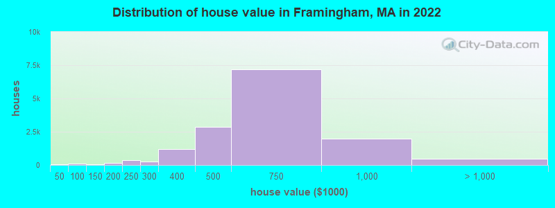
Estimated median house or condo value in 2022: $602,500 (it was $210,800 in 2000)
| Framingham: | $602,500 |
| MA: | $534,700 |
Mean prices in 2022: all housing units: $609,937; detached houses: $638,490; townhouses or other attached units: $384,612; in 2-unit structures: $509,966; in 5-or-more-unit structures: $284,823
Median gross rent in 2022: $1,707.
(5.6% for White Non-Hispanic residents, 14.6% for Black residents, 20.5% for Hispanic or Latino residents, 12.8% for other race residents, 22.4% for two or more races residents)
Detailed information about poverty and poor residents in Framingham, MA


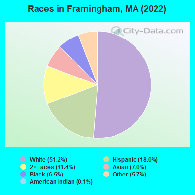
- 36,34151.2%White alone
- 12,73918.0%Hispanic
- 8,11111.4%Two or more races
- 4,9657.0%Asian alone
- 4,6246.5%Black alone
- 4,0745.7%Other race alone
- 930.1%American Indian alone
Races in Framingham detailed stats: ancestries, foreign born residents, place of birth
According to our research of Massachusetts and other state lists, there were 22 registered sex offenders living in Framingham, Massachusetts as of April 26, 2024.
The ratio of all residents to sex offenders in Framingham is 3,261 to 1.
The ratio of registered sex offenders to all residents in this city is lower than the state average.
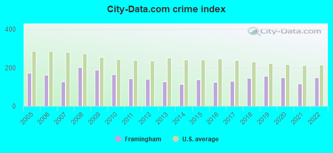
The City-Data.com crime index weighs serious crimes and violent crimes more heavily. Higher means more crime, U.S. average is 246.1. It adjusts for the number of visitors and daily workers commuting into cities.
- means the value is smaller than the state average.- means the value is about the same as the state average.
- means the value is bigger than the state average.
- means the value is much bigger than the state average.
Crime rate in Framingham detailed stats: murders, rapes, robberies, assaults, burglaries, thefts, arson
Full-time law enforcement employees in 2021, including police officers: 143 (123 officers - 109 male; 14 female).
| Officers per 1,000 residents here: | 1.64 |
| Massachusetts average: | 2.53 |
 Recent articles from our blog. Our writers, many of them Ph.D. graduates or candidates, create easy-to-read articles on a wide variety of topics.

 | Framingham: Majority-Minority City? (35 replies) |
| Working in Worcester: Live in Framingham or Worcester? (28 replies) |
| Woman found stabbed to death in her Framingham apartment. (1 reply) |
| Moving from Denver to somewhere between Boston and Framingham (25 replies) |
| Uxbridge commute to Framingham? (10 replies) |
| Framingham State Neighborhood Real Estate (5 replies) |
Latest news from Framingham, MA collected exclusively by city-data.com from local newspapers, TV, and radio stations
Framingham, MA City Guides:
Ancestries: Brazilian (19.6%), Irish (7.5%), Italian (5.9%), American (3.5%), English (2.9%), Russian (2.9%).
Current Local Time: EST time zone
Incorporated in 1700
Elevation: 165 feet
Land area: 25.1 square miles.
Population density: 2,825 people per square mile (average).
22,856 residents are foreign born (19.5% Latin America, 6.3% Asia).
| This place: | 31.9% |
| Massachusetts: | 17.6% |
Median real estate property taxes paid for housing units with mortgages in 2022: $6,231 (1.1%)
Median real estate property taxes paid for housing units with no mortgage in 2022: $6,765 (1.0%)
Nearest city with pop. 200,000+: Boston, MA  (17.3 miles , pop. 589,141).
Nearest city with pop. 1,000,000+: Bronx, NY (161.6 miles , pop. 1,332,650).
Nearest cities:
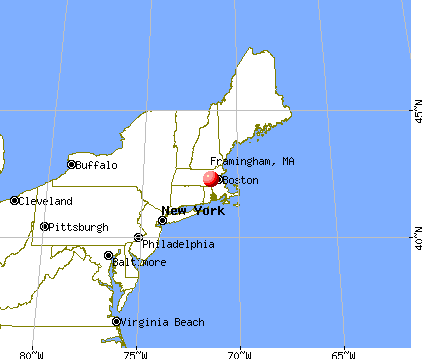
), ), Latitude: 42.30 N, Longitude: 71.43 W
Daytime population change due to commuting: +9,371 (+13.2%)
Workers who live and work in this place: 13,628 (38.7%)
Area codes: 508, 774
Framingham tourist attractions:
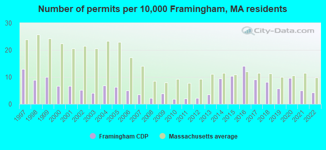
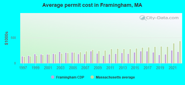
Single-family new house construction building permits:
- 2022: 29 buildings, average cost: $228,800
- 2021: 33 buildings, average cost: $256,600
- 2020: 64 buildings, average cost: $178,800
- 2019: 39 buildings, average cost: $164,300
- 2018: 55 buildings, average cost: $218,200
- 2017: 61 buildings, average cost: $236,200
- 2016: 94 buildings, average cost: $237,800
- 2015: 69 buildings, average cost: $213,500
- 2014: 63 buildings, average cost: $185,600
- 2013: 23 buildings, average cost: $201,700
- 2012: 15 buildings, average cost: $186,000
- 2011: 14 buildings, average cost: $178,000
- 2010: 12 buildings, average cost: $148,600
- 2009: 26 buildings, average cost: $194,800
- 2008: 15 buildings, average cost: $238,000
- 2007: 24 buildings, average cost: $179,700
- 2006: 33 buildings, average cost: $181,000
- 2005: 42 buildings, average cost: $215,300
- 2004: 46 buildings, average cost: $211,700
- 2003: 27 buildings, average cost: $224,600
- 2002: 35 buildings, average cost: $188,000
- 2001: 45 buildings, average cost: $176,300
- 2000: 45 buildings, average cost: $179,300
- 1999: 67 buildings, average cost: $184,300
- 1998: 60 buildings, average cost: $149,800
- 1997: 87 buildings, average cost: $141,200
| Here: | 3.0% |
| Massachusetts: | 3.5% |
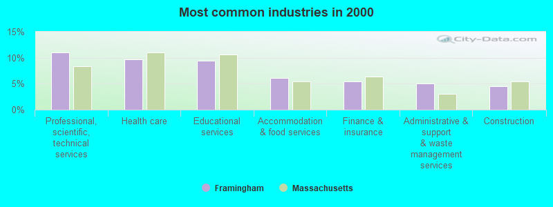
- Professional, scientific, technical services (11.0%)
- Health care (9.7%)
- Educational services (9.5%)
- Accommodation & food services (6.1%)
- Finance & insurance (5.4%)
- Administrative & support & waste management services (5.1%)
- Construction (4.5%)
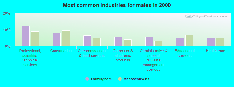
- Professional, scientific, technical services (12.6%)
- Construction (8.1%)
- Accommodation & food services (6.6%)
- Computer & electronic products (5.6%)
- Administrative & support & waste management services (5.4%)
- Educational services (5.1%)
- Health care (5.0%)
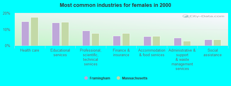
- Health care (14.9%)
- Educational services (14.2%)
- Professional, scientific, technical services (9.3%)
- Finance & insurance (6.0%)
- Accommodation & food services (5.6%)
- Administrative & support & waste management services (4.7%)
- Social assistance (3.7%)
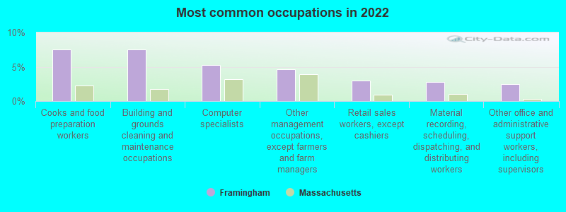
- Cooks and food preparation workers (7.6%)
- Building and grounds cleaning and maintenance occupations (7.6%)
- Computer specialists (5.3%)
- Other management occupations, except farmers and farm managers (4.6%)
- Retail sales workers, except cashiers (3.0%)
- Material recording, scheduling, dispatching, and distributing workers (2.8%)
- Other office and administrative support workers, including supervisors (2.5%)
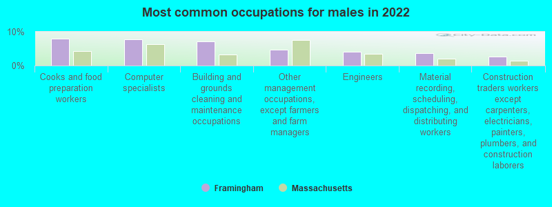
- Cooks and food preparation workers (7.9%)
- Computer specialists (7.8%)
- Building and grounds cleaning and maintenance occupations (7.0%)
- Other management occupations, except farmers and farm managers (4.7%)
- Engineers (4.1%)
- Material recording, scheduling, dispatching, and distributing workers (3.7%)
- Construction traders workers except carpenters, electricians, painters, plumbers, and construction laborers (2.6%)
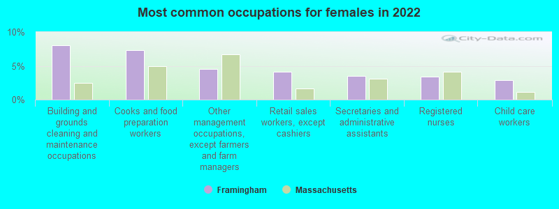
- Building and grounds cleaning and maintenance occupations (8.0%)
- Cooks and food preparation workers (7.3%)
- Other management occupations, except farmers and farm managers (4.5%)
- Retail sales workers, except cashiers (4.1%)
- Secretaries and administrative assistants (3.5%)
- Registered nurses (3.4%)
- Child care workers (2.9%)
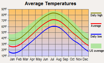
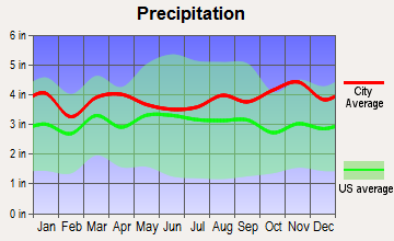
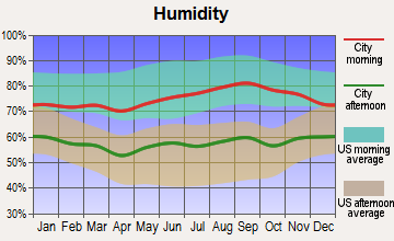
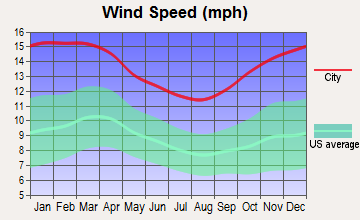
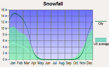
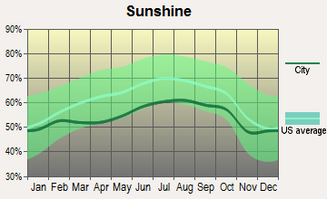
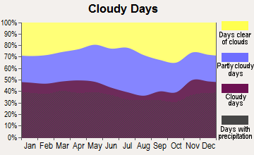
Average climate in Framingham, Massachusetts
Based on data reported by over 4,000 weather stations
|
|


(lower is better)
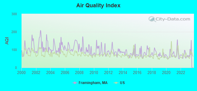
Air Quality Index (AQI) level in 2022 was 68.8. This is about average.
| City: | 68.8 |
| U.S.: | 72.6 |
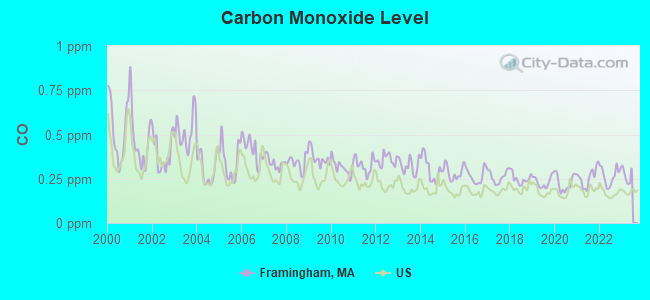
Carbon Monoxide (CO) [ppm] level in 2022 was 0.267. This is about average. Closest monitor was 11.0 miles away from the city center.
| City: | 0.267 |
| U.S.: | 0.251 |
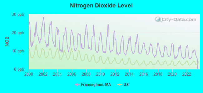
Nitrogen Dioxide (NO2) [ppb] level in 2022 was 8.40. This is significantly worse than average. Closest monitor was 1.0 miles away from the city center.
| City: | 8.40 |
| U.S.: | 5.11 |
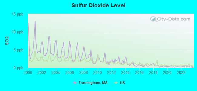
Sulfur Dioxide (SO2) [ppb] level in 2022 was 0.364. This is significantly better than average. Closest monitor was 1.0 miles away from the city center.
| City: | 0.364 |
| U.S.: | 1.515 |
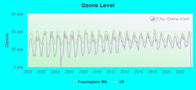
Ozone [ppb] level in 2022 was 29.3. This is about average. Closest monitor was 0.7 miles away from the city center.
| City: | 29.3 |
| U.S.: | 33.3 |
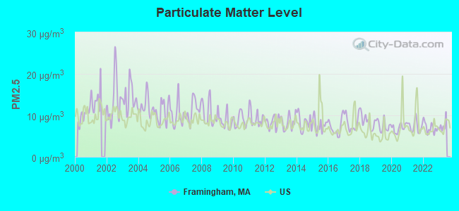
Particulate Matter (PM2.5) [µg/m3] level in 2022 was 7.01. This is about average. Closest monitor was 8.4 miles away from the city center.
| City: | 7.01 |
| U.S.: | 8.11 |
Tornado activity:
Framingham-area historical tornado activity is slightly above Massachusetts state average. It is 32% smaller than the overall U.S. average.
On 6/9/1953, a category F4 (max. wind speeds 207-260 mph) tornado 4.8 miles away from the Framingham place center killed 90 people and injured 1228 people and caused between $50,000,000 and $500,000,000 in damages.
On 10/3/1970, a category F3 (max. wind speeds 158-206 mph) tornado 19.3 miles away from the place center killed one person and caused between $50,000 and $500,000 in damages.
Earthquake activity:
Framingham-area historical earthquake activity is significantly above Massachusetts state average. It is 72% smaller than the overall U.S. average.On 10/7/1983 at 10:18:46, a magnitude 5.3 (5.1 MB, 5.3 LG, 5.1 ML, Class: Moderate, Intensity: VI - VII) earthquake occurred 186.4 miles away from the city center
On 4/20/2002 at 10:50:47, a magnitude 5.3 (5.3 ML, Depth: 3.0 mi) earthquake occurred 190.9 miles away from the city center
On 1/19/1982 at 00:14:42, a magnitude 4.7 (4.5 MB, 4.7 MD, 4.5 LG, Class: Light, Intensity: IV - V) earthquake occurred 83.5 miles away from the city center
On 4/20/2002 at 10:50:47, a magnitude 5.2 (5.2 MB, 4.2 MS, 5.2 MW, 5.0 MW) earthquake occurred 190.1 miles away from Framingham center
On 10/16/2012 at 23:12:25, a magnitude 4.7 (4.7 ML, Depth: 10.0 mi) earthquake occurred 97.9 miles away from the city center
On 8/22/1992 at 12:20:32, a magnitude 4.8 (4.8 MB, 3.8 MS, 4.7 LG, Depth: 6.2 mi) earthquake occurred 228.4 miles away from Framingham center
Magnitude types: regional Lg-wave magnitude (LG), body-wave magnitude (MB), duration magnitude (MD), local magnitude (ML), surface-wave magnitude (MS), moment magnitude (MW)
Natural disasters:
The number of natural disasters in Middlesex County (31) is a lot greater than the US average (15).Major Disasters (Presidential) Declared: 17
Emergencies Declared: 14
Causes of natural disasters: Floods: 12, Storms: 9, Hurricanes: 6, Snowstorms: 6, Winter Storms: 5, Blizzards: 2, Snows: 2, Explosion: 1, Heavy Rain: 1, Snowfall: 1, Water Main Break: 1, Wind: 1 (Note: some incidents may be assigned to more than one category).
Main business address for: ASA INTERNATIONAL LTD (SERVICES-COMPUTER INTEGRATED SYSTEMS DESIGN), PERINI CORP (GENERAL BUILDING CONTRACTORS - NONRESIDENTIAL BUILDINGS), NMS COMMUNICATIONS CORP (TELEPHONE & TELEGRAPH APPARATUS), LIFELINE SYSTEMS INC (RADIO & TV BROADCASTING & COMMUNICATIONS EQUIPMENT), STAPLES INC (RETAIL-MISCELLANEOUS SHOPPING GOODS STORES), GTC BIOTHERAPEUTICS INC (BIOLOGICAL PRODUCTS (NO DIAGNOSTIC SUBSTANCES)), TJX COMPANIES INC /DE/ (RETAIL-FAMILY CLOTHING STORES), Lifeline Systems, Inc. (RADIO & TV BROADCASTING & COMMUNICATIONS EQUIPMENT).
Hospitals in Framingham:
- CUSHING HOSP (DUDLEY RD)
- METROWEST MEDICAL CENTER (Voluntary non-profit - Private, 115 LINCOLN STREET)
Nursing Homes in Framingham:
- BETHANY SKILLED NURSING FACILITY (97 BETHANY ROAD)
- CARLYLE HOUSE (342 WINTER STREET)
- COUNTRYSIDE NURSING HOME INC (153 WINTER STREET)
- FRAMINGHAM NURSING HOME (517 WINTER STREET)
- KATHLEEN DANIEL (485 FRANKLIN STREET)
- KATHLEEN DANIEL NURSING HOME (485%FRANKLIN ST)
- METROWEST MEDICAL CENTER-TRANSITIONAL CARE UNITS (115 LINCOLN STREET)
- OAK KNOLL HEALTHCARE CENTER (9 ARBETTER DRIVE)
- RESIDENT CARE REHABILITATION AND NURSING (228 CONCORD STREET, P O BOX 887)
- ST PATRICK'S MANOR (863 CENTRAL STREET)
Dialysis Facilities in Framingham:
Home Health Centers in Framingham:
Colleges/Universities in Framingham:
Other colleges/universities with over 2000 students near Framingham:
- Wellesley College (about 7 miles; Wellesley, MA; Full-time enrollment: 2,658)
- Babson College (about 9 miles; Wellesley, MA; FT enrollment: 3,230)
- Massachusetts Bay Community College (about 9 miles; Wellesley Hills, MA; FT enrollment: 3,636)
- Brandeis University (about 10 miles; Waltham, MA; FT enrollment: 6,966)
- Bentley University (about 13 miles; Waltham, MA; FT enrollment: 5,229)
- Boston College (about 14 miles; Chestnut Hill, MA; FT enrollment: 12,070)
- Curry College (about 17 miles; Milton, MA; FT enrollment: 2,586)
Public high schools in Framingham:
- FRAMINGHAM HIGH SCHOOL (Students: 2,148, Location: 115 A STREET, Grades: 9-12)
- JOSEPH P KEEFE TECHNICAL HIGH SCHOOL (Students: 712, Location: 750 WINTER STREET, Grades: 9-12)
Private high schools in Framingham:
- MARIAN HIGH SCHOOL (Students: 303, Location: 273 UNION AVE, Grades: 9-12)
- THE LEARNING CENTER FOR THE DEAF (Students: 196, Location: 848 CENTRAL ST, Grades: PK-12)
- REED ACADEMY (Students: 42, Location: 1 WINCH ST, Grades: UG-9)
- WAYSIDE ACADEMY (Students: 26, Location: 1 FREDERICK ABBOTT WAY, Grades: 7-12)
Biggest public elementary/middle schools in Framingham:
- WALSH MIDDLE (Students: 743, Location: 301 BROOK STREET, Grades: 6-8)
- BARBIERI ELEMENTARY (Students: 606, Location: 100 DUDLEY RD, Grades: KG-5)
- FULLER MIDDLE (Students: 572, Location: 31 FLAGG DRIVE, Grades: 6-8)
- HEMENWAY (Students: 555, Location: 729 WATER STREET, Grades: KG-5)
- MIRIAM F MCCARTHY SCHOOL (Students: 502, Location: 8 FLAGG DRIVE, Grades: KG-5)
- CAMERON MIDDLE SCHOOL (Students: 496, Location: 215 ELM STREET, Grades: 6-8)
- CHARLOTTE A DUNNING (Students: 457, Location: 48 FROST STREET, Grades: KG-5)
- WOODROW WILSON (Students: 456, Location: 169 LELAND STREET, Grades: KG-5)
- BROPHY (Students: 442, Location: 575 PLEASANT STREET, Grades: KG-5)
- POTTER ROAD (Students: 437, Location: 492 POTTER RD, Grades: KG-5)
Private elementary/middle schools in Framingham:
- ST BRIDGET SCHOOL (Students: 329, Location: 832 WORCESTER RD, Grades: PK-8)
- SUMMIT MONTESSORI SCHOOL (Students: 68, Location: 283 PLEASANT ST, Grades: PK-6)
- METRO WEST JEWISH DAY SCHOOL (Students: 55, Location: 29 UPPER JOCLYN AVE STE 1, Grades: KG-7)
- THE BRIGHTON SCHOOL (Students: 44, Location: 360 WATER ST, Grades: PK-6)
Library in Framingham:
- FRAMINGHAM PUBLIC LIBRARY (Operating income: $2,737,022; Location: 49 LEXINGTON STREET; 245,627 books; 23,378 audio materials; 21,409 video materials; 3 local licensed databases; 31 state licensed databases; 3 other licensed databases; 398 print serial subscriptions; 5 electronic serial subscriptions)
Points of interest:
Notable locations in Framingham: Framingham Station (A), Framingham (B), Framingham Plaza (C), Old Trolley Square (D), Loring Arena (E), Cochituate Station (F), Framingham Industrial Park (G), Millwood Farms Golf Club (H), Framingham Fire Department Station 7 (I), Framingham Fire Department Station 5 (J), Framingham Fire Department Station 2 (K), Framingham Fire Department Station 1 (L), Atheneum Hall (M), Healing Partners Resource Library (N), Fuller Middle School Library (O), Framingham Fire Department Station 3 Headquarters (P), Center for Global Education Resource Library (Q), Cameron Middle School Library (R), Christa Corrigan McAulife Branch Framingham Public Library (S), Danforth Museum of Art (T). Display/hide their locations on the map
Shopping Centers: Route 30 Mall (1), Colonial Shopping Center (2), Nobscott Shopping Center (3), First National Shopping Center (4), Framingham Mall Shopping Center (5), Framingham Plaza Shopping Center (6), Framingham Shoppers World Shopping Center (7), Old Trolley Square Shopping Center (8), Pinefield Shopping Center (9). Display/hide their locations on the map
Main business address in Framingham include: ASA INTERNATIONAL LTD (A), PERINI CORP (B), NMS COMMUNICATIONS CORP (C), LIFELINE SYSTEMS INC (D), STAPLES INC (E), GTC BIOTHERAPEUTICS INC (F), TJX COMPANIES INC /DE/ (G), Lifeline Systems, Inc. (H). Display/hide their locations on the map
Churches in Framingham include: Wellesley Park Assembly of God Church (A), Wesley Methodist Church (B), Village Bible Chapel (C), The Lord Jesus Christ Assembly Church (D), Temple of Wisdom Church (E), Temple Baptist Church (F), South Middlesex Baptist Church (G), Shalom Pentecostal Church (H), Saint Tarcisius Church (I). Display/hide their locations on the map
Cemeteries: Saint Georges Cemetery (1), Church Hill Cemetery (2), Edgell Grove Cemetery (3), Saint Tarcisius Cemetery (4), Saint Stephens Cemetery (5), Edwards Cemetery (6). Display/hide their locations on the map
Lakes, reservoirs, and swamps: Gleason Pond (A), Learned Pond (B), Norton Pond (C), Sucker Pond (D), Waushakum Pond (E), Farm Pond (F), Sudbury Pond (G), Framingham Reservoir Number Three (H). Display/hide their locations on the map
Streams, rivers, and creeks: Angelica Brook (A), Baiting Brook (B), Willow Brook (C), Birch Meadow Brook (D), Cowassock Brook (E), Eames Brook (F), Cochituate Brook (G), Bannister Brook (H). Display/hide their locations on the map
Parks in Framingham include: Irving Square Historic District (1), Sucker Pond Playground (2), Sudbury Aqueduct Linear District (3), Longs Playground (4), Anna Murphy Playground (5), Butterworth Park (6), Burbank Circle Playground (7), Concord Square Historic District (8), Costanza Park (9). Display/hide their locations on the map
Tourist attractions: Framingham Historical Society (Museums; 6 Vernon Street) (1), Garden in the Woods of the New Land Wild FLWR SCTY - Information and Ev (Museums; Hemenway Road) (2), Garden in the Woods of the New Land Wild FLWR SCTY - Office (Museums; Hemenway Road) (3), Garden in the Woods of the New Land Wild FLWR SCTY (Museums; Hemenway Road) (4), Framingham Town - Libraries (Cultural Attractions- Events- & Facilities; 49 Lexington Street) (5), Framingham Town - Libraries- Telecommunications Device for the Deaf (Cultural Attractions- Events- & Facilities; 49 Lexington Street) (6), AL Faini Vending Inc (Amusement & Theme Parks; 28 Wilde Avenue) (7), Fun & Games (Amusement & Theme Parks; 50 Worcester Road) (8), New England Wild Flower Society (180 Hemenway Road) (9). Display/hide their approximate locations on the map
Hotels: Motel 6 (1668 Worcester Road) (1), Best Western Framingham (130 Worcester Road) (2), Econo Lodge Framingham (1186 Worcester Road) (3), Boston West - Framingham (1668 Worcester Rd) (4), Econo Lodge (1186 Worcester Road) (5), Dream Voyages (34 Salem End Road) (6), Red Roof Inns (650 Cochituate Road) (7), Red Roof Inns - Framingham (650 Cochituate Road) (8), Sheraton Framingham Hotel (Exit 12 To Route 9 West) (9). Display/hide their approximate locations on the map
Courts: United Transportation Union (74 Main) (1), Mass Commonwealth - Framingham Juvenile Court (110 Mount Wayte Avenue) (2), Framingham District Court - Chief Psychiatrist (600 Concord Street) (3), Mass Commonwealth - Trial Court- Framingham District Court- Jury Stand-By Ser (600 Concord Street) (4), The Commonwealth of Massachusetts Trial Court (600 Concord Street) (5), Framingham District Court - Juvenile Probation (600 Concord Street) (6), Framingham District Court - Adult Probation (600 Concord Street) (7), Middlesex County - First District Court South Middlesex- Middlesex Deputy Sheriffs Central Dist (160 Cochituate Road) (8), Mass Commonwealth - Mental Health- Framingham Court Clinic (600 Concord Street) (9). Display/hide their approximate locations on the map
Birthplace of: John Stagikas - Professional wrestler, Pie Traynor - Baseball player, Max Bauer (wrestler) - Professional wrestler, Stan Benjamin - Major League Baseball player, Jorge Rivera (fighter) - Martial artist, Adam Schiff - Politician, Charles Henry Parkhurst - Clergyman, Arthur Raymond Brooks - Aviator, Rob Urbinati - Dramatists and playwright, Carl Corazzini - NHL player (Boston Bruins, born: Apr 21, 1979).
Drinking water stations with addresses in Framingham and their reported violations in the past:
FRAMINGHAM WATER DEPT. (MWRA) (Population served: 68,318, Purch surface water):Past monitoring violations:CUMBERLAND FARMS #1587 (Address: 100 CROSSING BLVD., V1047 , Serves NY, Population served: 300, Groundwater):
- One routine major monitoring violation
Past monitoring violations:CUMBERLAND FARMS 1575 (Address: 100 CROSS BOULEVARD , Serves NY, Population served: 300, Groundwater):
- 10 routine major monitoring violations
- 272 regular monitoring violations
Past monitoring violations:CUMBERLAND FARMS STORES, STORE #1274 (Serves RI, Population served: 120, Groundwater):
- 4 routine major monitoring violations
- One regular monitoring violation
Past health violations:Past monitoring violations:
- MCL, Monthly (TCR) - In JUL-2007, Contaminant: Coliform. Follow-up actions: St Public Notif requested (JUL-09-2007), St Formal NOV issued (JUL-09-2007), St Violation/Reminder Notice (JUL-09-2007), St Boil Water Order (JUL-09-2007), St Compliance achieved (AUG-28-2007), St Public Notif received (AUG-28-2007)
- One routine major monitoring violation
Drinking water stations with addresses in Framingham that have no violations reported:
- PETES PIZZA PLUS (Serves RI, Population served: 40, Primary Water Source Type: Groundwater)
| This place: | 2.5 people |
| Massachusetts: | 2.5 people |
| This place: | 63.2% |
| Whole state: | 63.0% |
| This place: | 5.9% |
| Whole state: | 7.0% |
Likely homosexual households (counted as self-reported same-sex unmarried-partner households)
- Lesbian couples: 0.5% of all households
- Gay men: 0.4% of all households
People in group quarters in Framingham in 2010:
- 1,471 people in college/university student housing
- 831 people in nursing facilities/skilled-nursing facilities
- 763 people in state prisons
- 205 people in other noninstitutional facilities
- 163 people in group homes intended for adults
- 102 people in residential schools for people with disabilities
- 90 people in emergency and transitional shelters (with sleeping facilities) for people experiencing homelessness
- 76 people in residential treatment centers for adults
- 60 people in residential treatment centers for juveniles (non-correctional)
People in group quarters in Framingham in 2000:
- 1,233 people in college dormitories (includes college quarters off campus)
- 920 people in nursing homes
- 812 people in state prisons
- 113 people in other noninstitutional group quarters
- 104 people in religious group quarters
- 73 people in other nonhousehold living situations
- 42 people in homes or halfway houses for drug/alcohol abuse
- 14 people in homes for the mentally retarded
- 7 people in homes for the mentally ill
Banks with branches in Framingham (2011 data):
- TD Bank, National Association: Metrowest Bank Branch, Edgell Road Store Branch, Worcester Road Branch, Franklin Street Branch, Old Worcester-Temple Branch. Info updated 2010/10/04: Bank assets: $188,912.6 mil, Deposits: $153,149.8 mil, headquarters in Wilmington, DE, positive income, 1314 total offices, Holding Company: Toronto-Dominion Bank, The
- RBS Citizens, National Association: Carmel Terrace Branch, Framingham S&S Turnpike Branch, Framingham Old Ct Path Stop And Shop, Framingham Branch, Hamilton Plaza Branch. Info updated 2007/09/19: Bank assets: $106,940.6 mil, Deposits: $75,690.2 mil, headquarters in Providence, RI, positive income, 1135 total offices, Holding Company: Uk Financial Investments Limited
- Middlesex Savings Bank: Old Connecticut Path Branch, Route 9 Framingham Branch, Framingham Branch. Info updated 2009/07/16: Bank assets: $4,034.8 mil, Deposits: $3,490.0 mil, headquarters in Natick, MA, positive income, Mortgage Lending Specialization, 33 total offices, Holding Company: Middlesex Bancorp Mhc
- Sovereign Bank, National Association: Framingham Centre Branch, Union Avenue Branch, Whittier Street Branch. Info updated 2012/01/31: Bank assets: $78,146.9 mil, Deposits: $48,042.9 mil, headquarters in Wilmington, DE, positive income, Commercial Lending Specialization, 718 total offices, Holding Company: Banco Santander, S.A.
- Bank of America, National Association: Route 30, Framingham Branch, Framingham Branch, Framingham Branch. Info updated 2009/11/18: Bank assets: $1,451,969.3 mil, Deposits: $1,077,176.8 mil, headquarters in Charlotte, NC, positive income, 5782 total offices, Holding Company: Bank Of America Corporation
- Framingham Co-operative Bank: Lincoln Street Branch at One Lincoln Street, branch established on 1997/06/09; Framingham Co-Operative Bank at 828 Concord Street, branch established on 1889/01/01. Info updated 2006/11/03: Bank assets: $398.5 mil, Deposits: $303.8 mil, local headquarters, positive income, Commercial Lending Specialization, 2 total offices
For population 15 years and over in Framingham:
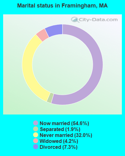
- Never married: 32.0%
- Now married: 54.6%
- Separated: 1.9%
- Widowed: 4.2%
- Divorced: 7.3%
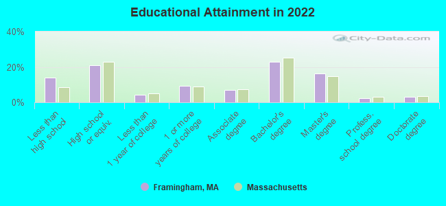
For population 25 years and over in Framingham:
- High school or higher: 86.1%
- Bachelor's degree or higher: 44.4%
- Graduate or professional degree: 21.5%
- Unemployed: 2.9%
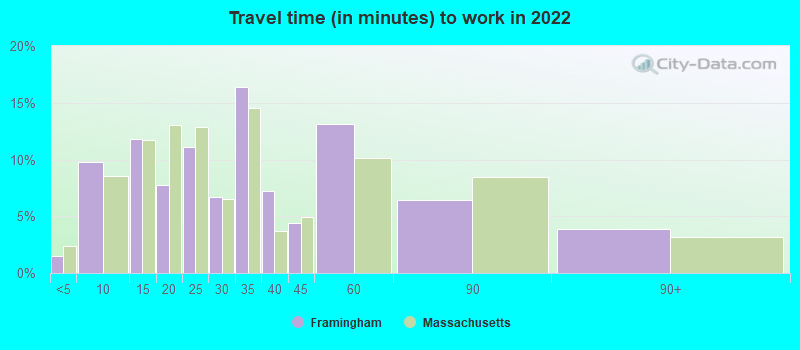
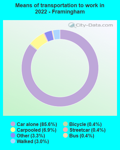
- Mean travel time to work (commute): 23.2 minutes
| Here: | 14.3 |
| Massachusetts average: | 13.0 |


Graphs represent county-level data. Detailed 2008 Election Results
Neighborhoods in Framingham:
(Framingham, Massachusetts Neighborhood Map)Religion statistics for Framingham, MA (based on Middlesex County data)


| Religion | Adherents | Congregations |
|---|---|---|
| Catholic | 718,209 | 107 |
| Mainline Protestant | 70,053 | 269 |
| Other | 68,480 | 199 |
| Evangelical Protestant | 41,270 | 304 |
| Orthodox | 23,641 | 28 |
| Black Protestant | 2,276 | 8 |
| None | 579,156 | - |
Food Environment Statistics:
| Middlesex County: | 1.71 / 10,000 pop. |
| Massachusetts: | 1.98 / 10,000 pop. |
| This county: | 0.03 / 10,000 pop. |
| State: | 0.05 / 10,000 pop. |
| Here: | 2.14 / 10,000 pop. |
| State: | 2.22 / 10,000 pop. |
| Middlesex County: | 1.38 / 10,000 pop. |
| Massachusetts: | 1.77 / 10,000 pop. |
| This county: | 7.84 / 10,000 pop. |
| Massachusetts: | 8.76 / 10,000 pop. |
| Middlesex County: | 7.8% |
| Massachusetts: | 8.1% |
| Middlesex County: | 21.5% |
| Massachusetts: | 22.5% |
| Middlesex County: | 18.0% |
| Massachusetts: | 16.5% |
Health and Nutrition:
| Here: | 51.6% |
| Massachusetts: | 50.5% |
| Framingham: | 50.5% |
| Massachusetts: | 48.0% |
| This city: | 28.3 |
| Massachusetts: | 28.4 |
| Here: | 19.9% |
| Massachusetts: | 20.7% |
| Here: | 10.0% |
| Massachusetts: | 10.4% |
| Framingham: | 6.8 |
| Massachusetts: | 6.8 |
| Framingham: | 32.9% |
| Massachusetts: | 33.4% |
| This city: | 58.7% |
| Massachusetts: | 57.1% |
| This city: | 80.5% |
| Massachusetts: | 79.2% |
More about Health and Nutrition of Framingham, MA Residents
| Local government employment and payroll (March 2022) | |||||
| Function | Full-time employees | Monthly full-time payroll | Average yearly full-time wage | Part-time employees | Monthly part-time payroll |
|---|---|---|---|---|---|
| Elementary and Secondary - Instruction | 1,102 | $7,030,132 | $76,553 | 59 | $29,441 |
| Elementary and Secondary - Other Total | 227 | $1,073,313 | $56,739 | 121 | $31,571 |
| Firefighters | 140 | $1,057,739 | $90,663 | 0 | $0 |
| Police Protection - Officers | 124 | $1,233,958 | $119,415 | 0 | $0 |
| Other and Unallocable | 48 | $312,521 | $78,130 | 8 | $2,539 |
| Streets and Highways | 44 | $362,242 | $98,793 | 0 | $0 |
| Local Libraries | 42 | $226,319 | $64,663 | 22 | $51,061 |
| Financial Administration | 41 | $280,010 | $81,954 | 4 | $11,270 |
| Parks and Recreation | 31 | $219,602 | $85,007 | 13 | $1,127 |
| Water Supply | 27 | $174,484 | $77,548 | 0 | $0 |
| Sewerage | 19 | $129,023 | $81,488 | 0 | $0 |
| Solid Waste Management | 17 | $100,354 | $70,838 | 0 | $0 |
| Police - Other | 15 | $88,457 | $70,766 | 10 | $9,837 |
| Other Government Administration | 13 | $88,683 | $81,861 | 17 | $5,278 |
| Housing and Community Development (Local) | 7 | $49,551 | $84,945 | 0 | $0 |
| Welfare | 6 | $38,061 | $76,122 | 11 | $16,129 |
| Health | 0 | $0 | 7 | $5,121 | |
| Totals for Government | 1,903 | $12,464,451 | $78,599 | 272 | $163,375 |
Framingham government finances - Expenditure in 2021 (per resident):
- Construction - Elementary and Secondary Education: $47,029,000 ($662.73)
General Public Buildings: $2,655,000 ($37.41)
- Current Operations - Elementary and Secondary Education: $193,324,000 ($2724.29)
General - Other: $49,132,000 ($692.36)
Sewerage: $18,576,000 ($261.77)
Water Utilities: $14,928,000 ($210.36)
Local Fire Protection: $14,555,000 ($205.11)
Police Protection: $14,178,000 ($199.79)
Regular Highways: $10,200,000 ($143.74)
General Public Buildings: $5,305,000 ($74.76)
Solid Waste Management: $4,207,000 ($59.28)
Financial Administration: $3,408,000 ($48.03)
Parks and Recreation: $2,919,000 ($41.13)
Libraries: $2,833,000 ($39.92)
Central Staff Services: $1,951,000 ($27.49)
Protective Inspection and Regulation - Other: $1,354,000 ($19.08)
Health - Other: $1,068,000 ($15.05)
Housing and Community Development: $1,056,000 ($14.88)
Judicial and Legal Services: $641,000 ($9.03)
Public Welfare - Other: $461,000 ($6.50)
Natural Resources - Other: $62,000 ($0.87)
- General - Interest on Debt: $8,825,000 ($124.36)
- Intergovernmental to Local - Other - Elementary and Secondary Education: $10,178,000 ($143.43)
Other - Central Staff Services: $39,000 ($0.55)
Other - Health - Other: $22,000 ($0.31)
- Intergovernmental to State - Transit Utilities: $1,707,000 ($24.05)
General - Other: $98,000 ($1.38)
- Other Capital Outlay - Water Utilities: $4,056,000 ($57.16)
General - Other: $3,464,000 ($48.81)
Elementary and Secondary Education: $2,090,000 ($29.45)
Sewerage: $2,009,000 ($28.31)
Regular Highways: $1,356,000 ($19.11)
Police Protection: $188,000 ($2.65)
Parks and Recreation: $117,000 ($1.65)
Local Fire Protection: $18,000 ($0.25)
Solid Waste Management: $16,000 ($0.23)
Financial Administration: $11,000 ($0.16)
General Public Building: $5,000 ($0.07)
Libraries: $4,000 ($0.06)
- Total Salaries and Wages: $117,426,000 ($1654.75)
- Water Utilities - Interest on Debt: $2,046,000 ($28.83)
Framingham government finances - Revenue in 2021 (per resident):
- Charges - Sewerage: $26,092,000 ($367.68)
Other: $3,133,000 ($44.15)
Elementary and Secondary Education School Tuition and Transportation: $1,172,000 ($16.52)
Elementary and Secondary Education School Lunch: $929,000 ($13.09)
Elementary and Secondary Education - Other: $564,000 ($7.95)
Solid Waste Management: $355,000 ($5.00)
Parks and Recreation: $343,000 ($4.83)
Parking Facilities: $47,000 ($0.66)
- Federal Intergovernmental - Other: $11,665,000 ($164.38)
Housing and Community Development: $1,192,000 ($16.80)
Highways: $75,000 ($1.06)
- Miscellaneous - Interest Earnings: $6,874,000 ($96.87)
General Revenue - Other: $2,164,000 ($30.49)
Donations From Private Sources: $405,000 ($5.71)
Fines and Forfeits: $404,000 ($5.69)
- Revenue - Water Utilities: $21,188,000 ($298.58)
- State Intergovernmental - Education: $93,072,000 ($1311.56)
General Local Government Support: $11,311,000 ($159.39)
Highways: $3,234,000 ($45.57)
Other: $2,566,000 ($36.16)
Public Welfare: $388,000 ($5.47)
Housing and Community Development: $219,000 ($3.09)
- Tax - Property: $205,824,000 ($2900.44)
Other License: $3,825,000 ($53.90)
Other Selective Sales: $1,775,000 ($25.01)
Framingham government finances - Debt in 2021 (per resident):
- Long Term Debt - Outstanding Unspecified Public Purpose: $251,866,000 ($3549.26)
Beginning Outstanding - Unspecified Public Purpose: $240,615,000 ($3390.71)
Issue, Unspecified Public Purpose: $38,540,000 ($543.10)
Retired Unspecified Public Purpose: $27,289,000 ($384.55)
- Short Term Debt Outstanding - Beginning: $48,316,000 ($680.86)
End of Fiscal Year: $29,537,000 ($416.23)
Framingham government finances - Cash and Securities in 2021 (per resident):
- Bond Funds - Cash and Securities: $13,119,000 ($184.87)
- Other Funds - Cash and Securities: $66,551,000 ($937.83)
6.91% of this county's 2021 resident taxpayers lived in other counties in 2020 ($102,955 average adjusted gross income)
| Here: | 6.91% |
| Massachusetts average: | 6.35% |
0.01% of residents moved from foreign countries ($137 average AGI)
Middlesex County: 0.01% Massachusetts average: 0.01%
Top counties from which taxpayers relocated into this county between 2020 and 2021:
| from Suffolk County, MA | |
| from Essex County, MA | |
| from Norfolk County, MA |
8.22% of this county's 2020 resident taxpayers moved to other counties in 2021 ($123,369 average adjusted gross income)
| Here: | 8.22% |
| Massachusetts average: | 7.18% |
0.01% of residents moved to foreign countries ($124 average AGI)
Middlesex County: 0.01% Massachusetts average: 0.02%
Top counties to which taxpayers relocated from this county between 2020 and 2021:
| to Suffolk County, MA | |
| to Essex County, MA | |
| to Worcester County, MA |
| Businesses in Framingham, MA | ||||
| Name | Count | Name | Count | |
|---|---|---|---|---|
| AT&T | 2 | New Balance | 1 | |
| AutoZone | 1 | Nike | 4 | |
| Barnes & Noble | 1 | Nordstrom | 1 | |
| Bed Bath & Beyond | 1 | Office Depot | 1 | |
| Best Western | 1 | Old Navy | 1 | |
| Blockbuster | 1 | Olive Garden | 1 | |
| Budget Car Rental | 1 | Panera Bread | 1 | |
| Burger King | 2 | Payless | 1 | |
| CVS | 3 | Penske | 1 | |
| Chevrolet | 1 | PetSmart | 1 | |
| Chipotle | 1 | Red Roof Inn | 1 | |
| Circle K | 1 | Ruby Tuesday | 1 | |
| Decora Cabinetry | 2 | SAS Shoes | 1 | |
| Domino's Pizza | 1 | Sheraton | 1 | |
| Dunkin Donuts | 10 | Sprint Nextel | 1 | |
| Econo Lodge | 1 | Staples | 1 | |
| FedEx | 21 | Starbucks | 2 | |
| Ford | 1 | Stop & Shop | 2 | |
| GameStop | 1 | Subway | 5 | |
| H&R Block | 1 | T-Mobile | 3 | |
| Hyundai | 1 | T.G.I. Driday's | 1 | |
| JoS. A. Bank | 1 | T.J.Maxx | 1 | |
| Jones New York | 1 | Taco Bell | 1 | |
| KFC | 1 | Target | 1 | |
| Kohl's | 1 | Toyota | 1 | |
| Lane Furniture | 1 | Toys"R"Us | 2 | |
| Lowe's | 1 | Trader Joe's | 1 | |
| Macy's | 1 | U-Haul | 1 | |
| Marriott | 1 | UPS | 19 | |
| Marshalls | 1 | Verizon Wireless | 2 | |
| MasterBrand Cabinets | 9 | Walgreens | 2 | |
| McDonald's | 3 | Walmart | 1 | |
| Men's Wearhouse | 2 | Whole Foods Market | 1 | |
| Motel 6 | 1 | YMCA | 2 | |
| Motherhood Maternity | 1 | |||
Strongest AM radio stations in Framingham:
- WKOX (1200 AM; 50 kW; FRAMINGHAM, MA; Owner: CAPSTAR TX LIMITED PARTNERSHIP)
- WBIX (1060 AM; 40 kW; NATICK, MA; Owner: LANGER BROADCASTING CORPORATION)
- WAMG (890 AM; 25 kW; DEDHAM, MA; Owner: MEGA COMMUNICATIONS OF DEDHAM LICENSEE, LLC)
- WEEI (850 AM; 50 kW; BOSTON, MA; Owner: ENTERCOM BOSTON LICENSE, LLC)
- WRKO (680 AM; 50 kW; BOSTON, MA; Owner: ENTERCOM BOSTON LICENSE, LLC)
- WRCA (1330 AM; 25 kW; WALTHAM, MA; Owner: WRCA LICENSE, LLC)
- WSRO (650 AM; 2 kW; ASHLAND, MA; Owner: LANGER BROADCASTING GROUP, LLC)
- WWZN (1510 AM; 50 kW; BOSTON, MA; Owner: ROSE CITY RADIO CORPORATION)
- WUNR (1600 AM; 20 kW; BROOKLINE, MA; Owner: CHAMPION BROADCASTING SYSTEMS, INC.)
- WCRN (830 AM; 50 kW; WORCESTER, MA; Owner: CARTER BROADCASTING CORPORATION)
- WALE (990 AM; 50 kW; GREENVILLE, RI; Owner: NORTH AMERICAN BROADCASTING CO., INC.)
- WNTN (1550 AM; 10 kW; NEWTON, MA; Owner: COLT COMMUNICATIONS, LLC)
- WBZ (1030 AM; 50 kW; BOSTON, MA; Owner: INFINITY BROADCASTING OPERATIONS, INC.)
Strongest FM radio stations in Framingham:
- WDJM-FM (91.3 FM; FRAMINGHAM, MA; Owner: FRAMINGHAM STATE COLLEGE)
- WBMX (98.5 FM; BOSTON, MA; Owner: INFINITY RADIO OPERATIONS INC.)
- WJMN (94.5 FM; BOSTON, MA; Owner: AMFM RADIO LICENSES, L.L.C.)
- WGBH (89.7 FM; BOSTON, MA; Owner: WGBH EDUCATIONAL FOUNDATION)
- WCRB (102.5 FM; WALTHAM, MA; Owner: CHARLES RIVER BROADCASTING WCRB LICE)
- WTKK (96.9 FM; BOSTON, MA; Owner: GREATER BOSTON RADIO, INC.)
- WROR-FM (105.7 FM; FRAMINGHAM, MA; Owner: GREATER BOSTON RADIO, INC.)
- WBOS (92.9 FM; BROOKLINE, MA; Owner: GREATER BOSTON RADIO, INC.)
- WBUR-FM (90.9 FM; BOSTON, MA; Owner: TRUSTEES OF BOSTON UNIVERSITY)
- WODS (103.3 FM; BOSTON, MA; Owner: INFINITY BROADCASTING OPERATIONS, INC.)
- WXKS-FM (107.9 FM; MEDFORD, MA; Owner: AMFM RADIO LICENSES, L.L.C.)
- WMJX (106.7 FM; BOSTON, MA; Owner: GREATER BOSTON RADIO, INC.)
- WYAJ (97.7 FM; SUDBURY, MA; Owner: SUDBURY VALLEY B'CASTING FOUNDATION)
- WBCN (104.1 FM; BOSTON, MA; Owner: HEMISPHERE BROADCASTING CORPORATION)
- WZLX (100.7 FM; BOSTON, MA; Owner: INFINITY BROADCASTING CORPORATION OF BOSTON)
- WHHB (99.9 FM; HOLLISTON, MA; Owner: HOLLISTON HIGH SCHOOL)
- WAAF (107.3 FM; WORCESTER, MA; Owner: ENTERCOM BOSTON LICENSE, LLC)
- W267AI (101.3 FM; BOSTON, MA; Owner: MCC BROADCASTING COMPANY, INC.)
- WERS (88.9 FM; BOSTON, MA; Owner: EMERSON COLLEGE)
- WZLY (91.5 FM; WELLESLEY, MA; Owner: WELLESLEY COLLEGE)
TV broadcast stations around Framingham:
- WUTF (Channel 66; MARLBOROUGH, MA; Owner: TELEFUTURA BOSTON LLC)
- WCVB-TV (Channel 5; BOSTON, MA; Owner: WCVB HEARST-ARGYLE TV, INC.)
- WGBH-TV (Channel 2; BOSTON, MA; Owner: WGBH EDUCATIONAL FOUNDATION)
- WBZ-TV (Channel 4; BOSTON, MA; Owner: VIACOM INC.)
- WGBX-TV (Channel 44; BOSTON, MA; Owner: WGBH EDUCATIONAL FOUNDATION)
- WMFP (Channel 62; LAWRENCE, MA; Owner: WSAH LICENSE, INC.)
- WHDH-TV (Channel 7; BOSTON, MA; Owner: WHDH-TV)
- WSBK-TV (Channel 38; BOSTON, MA; Owner: VIACOM INC.)
- WLVI-TV (Channel 56; CAMBRIDGE, MA; Owner: WLVI, INC.)
- WFXT (Channel 25; BOSTON, MA; Owner: FOX TELEVISION STATIONS INC.)
- W40BO (Channel 40; BOSTON, MA; Owner: PAXSON COMMUNICATIONS LPTV, INC.)
- WUNI (Channel 27; WORCESTER, MA; Owner: ENTRAVISION HOLDINGS, LLC)
- WBPX (Channel 68; BOSTON, MA; Owner: PAXSON BOSTON-68 LICENSE, INC.)
- WTMU-LP (Channel 32; BOSTON, MA; Owner: ZGS BOSTON, INC.)
- WCEA-LP (Channel 58; BOSTON, MA; Owner: CHANNEL 19 TV CORPORATION)
- WWDP (Channel 46; NORWELL, MA; Owner: NORWELL TELEVISION, LLC)
- WNAC-TV (Channel 64; PROVIDENCE, RI; Owner: WNAC, LLC)
- WPRI-TV (Channel 12; PROVIDENCE, RI; Owner: TVL BROADCASTING OF RHODE ISLAND, LLC)
- WLNE-TV (Channel 6; NEW BEDFORD, MA; Owner: FREEDOM BROADCASTING OF SOUTHERN NEW ENGLAND, INC.)
- WJAR (Channel 10; PROVIDENCE, RI; Owner: OUTLET BROADCASTING, INC.)
- WFXZ-CA (Channel 24; BOSTON, MA; Owner: BOSTON BROADCASTING CORP.)
- WYDN (Channel 48; WORCESTER, MA; Owner: EDUCATIONAL PUBLIC TV CORPORATION)
- WSBE-TV (Channel 36; PROVIDENCE, RI; Owner: RHODE ISLAND PUBLIC TELECOM. AUTHORITY)
- WPXQ (Channel 69; BLOCK ISLAND, RI; Owner: OCEAN STATE TELEVISION, L.L.C.)
- WNDS (Channel 50; DERRY, NH; Owner: CTV OF DERRY, INC)

- National Bridge Inventory (NBI) Statistics
- 68Number of bridges
- 646ft / 197mTotal length
- $155,747,000Total costs
- 1,979,831Total average daily traffic
- 121,946Total average daily truck traffic
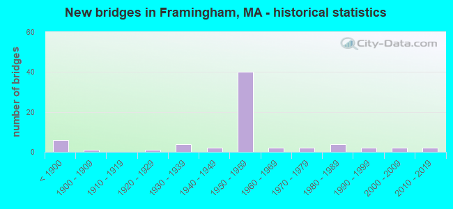
- New bridges - historical statistics
- 6Before 1900
- 11900-1909
- 11920-1929
- 41930-1939
- 21940-1949
- 401950-1959
- 21960-1969
- 21970-1979
- 41980-1989
- 21990-1999
- 22000-2009
- 22010-2019
FCC Registered Commercial Land Mobile Towers: 1 (See the full list of FCC Registered Commercial Land Mobile Towers in Framingham, MA)
FCC Registered Private Land Mobile Towers: 5 (See the full list of FCC Registered Private Land Mobile Towers)
FCC Registered Broadcast Land Mobile Towers: 54 (See the full list of FCC Registered Broadcast Land Mobile Towers)
FCC Registered Microwave Towers: 55 (See the full list of FCC Registered Microwave Towers in this town)
FCC Registered Paging Towers: 12 (See the full list of FCC Registered Paging Towers)
FCC Registered Amateur Radio Licenses: 379 (See the full list of FCC Registered Amateur Radio Licenses in Framingham)
FAA Registered Aircraft: 21 (See the full list of FAA Registered Aircraft in Framingham)
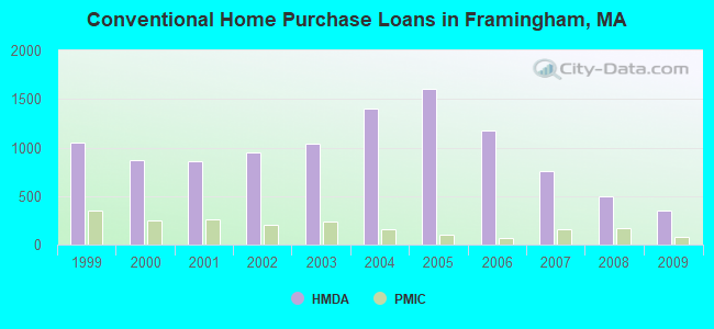
| Home Mortgage Disclosure Act Aggregated Statistics For Year 2009 (Based on 12 full tracts) | ||||||||||||
| A) FHA, FSA/RHS & VA Home Purchase Loans | B) Conventional Home Purchase Loans | C) Refinancings | D) Home Improvement Loans | E) Loans on Dwellings For 5+ Families | F) Non-occupant Loans on < 5 Family Dwellings (A B C & D) | |||||||
|---|---|---|---|---|---|---|---|---|---|---|---|---|
| Number | Average Value | Number | Average Value | Number | Average Value | Number | Average Value | Number | Average Value | Number | Average Value | |
| LOANS ORIGINATED | 199 | $252,824 | 347 | $226,427 | 1,569 | $259,314 | 99 | $130,657 | 8 | $1,006,875 | 84 | $268,881 |
| APPLICATIONS APPROVED, NOT ACCEPTED | 10 | $184,700 | 33 | $198,848 | 121 | $256,405 | 8 | $138,750 | 1 | $370,000 | 6 | $136,333 |
| APPLICATIONS DENIED | 44 | $199,341 | 86 | $196,965 | 378 | $268,561 | 32 | $79,281 | 3 | $465,000 | 39 | $189,231 |
| APPLICATIONS WITHDRAWN | 33 | $201,606 | 50 | $219,020 | 258 | $265,019 | 9 | $181,667 | 0 | $0 | 19 | $180,579 |
| FILES CLOSED FOR INCOMPLETENESS | 3 | $217,667 | 12 | $188,500 | 91 | $252,121 | 2 | $42,500 | 0 | $0 | 6 | $263,500 |
Detailed mortgage data for all 12 tracts in Framingham, MA
| Private Mortgage Insurance Companies Aggregated Statistics For Year 2009 (Based on 12 full tracts) | ||||
| A) Conventional Home Purchase Loans | B) Refinancings | |||
|---|---|---|---|---|
| Number | Average Value | Number | Average Value | |
| LOANS ORIGINATED | 78 | $263,333 | 63 | $307,333 |
| APPLICATIONS APPROVED, NOT ACCEPTED | 30 | $293,967 | 23 | $292,478 |
| APPLICATIONS DENIED | 7 | $312,571 | 10 | $290,400 |
| APPLICATIONS WITHDRAWN | 6 | $225,500 | 6 | $351,667 |
| FILES CLOSED FOR INCOMPLETENESS | 0 | $0 | 3 | $288,000 |
2002 - 2018 National Fire Incident Reporting System (NFIRS) incidents
- Fire incident types reported to NFIRS in Framingham, MA
- 6,19575.4%Structure Fires
- 1,46817.9%Outside Fires
- 5396.6%Mobile Property/Vehicle Fires
- 120.1%Other
 According to the data from the years 2002 - 2018 the average number of fires per year is 483. The highest number of fires - 648 took place in 2018, and the least - 363 in 2002. The data has a growing trend.
 When looking into fire subcategories, the most incidents belonged to: Structure Fires (75.4%), and Outside Fires (17.9%).
Fire-safe hotels and motels in Framingham, Massachusetts:
- Econo Lodge, 1186 Worcester Rd, Framingham, Massachusetts 01701 , Phone: (508) 879-1510, Fax: (508) 879-1510
- Monticello Inn, 90 Worcester Rd, Framingham, Massachusetts 01702 , Phone: (508) 875-1394, Fax: (508) 875-2392
| Most common first names in Framingham, MA among deceased individuals | ||
| Name | Count | Lived (average) |
|---|---|---|
| Mary | 919 | 82.8 years |
| John | 588 | 75.3 years |
| William | 373 | 75.2 years |
| Joseph | 323 | 76.4 years |
| Margaret | 317 | 83.9 years |
| Robert | 300 | 69.7 years |
| Helen | 290 | 82.3 years |
| James | 257 | 73.6 years |
| Charles | 235 | 75.7 years |
| George | 207 | 75.3 years |
| Most common last names in Framingham, MA among deceased individuals | ||
| Last name | Count | Lived (average) |
|---|---|---|
| Smith | 120 | 78.5 years |
| Sullivan | 102 | 78.8 years |
| Murphy | 90 | 80.1 years |
| Brown | 77 | 77.0 years |
| Johnson | 60 | 79.6 years |
| Davis | 51 | 77.0 years |
| White | 51 | 76.0 years |
| Miller | 47 | 72.9 years |
| Ryan | 47 | 79.0 years |
| Mccarthy | 44 | 79.2 years |
- 52.3%Utility gas
- 34.1%Fuel oil, kerosene, etc.
- 8.6%Electricity
- 1.7%Bottled, tank, or LP gas
- 1.6%Other fuel
- 1.2%Wood
- 0.3%Coal or coke
- 0.1%Solar energy
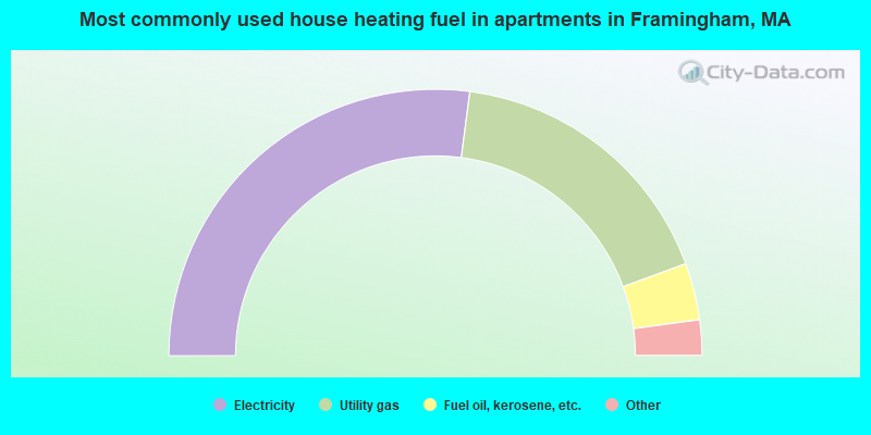
- 54.2%Electricity
- 34.7%Utility gas
- 6.9%Fuel oil, kerosene, etc.
- 3.4%Bottled, tank, or LP gas
- 0.7%Other fuel
- 0.2%No fuel used
Framingham compared to Massachusetts state average:
- Unemployed percentage significantly below state average.
- Foreign-born population percentage above state average.
- Institutionalized population percentage above state average.
Framingham on our top lists:
- #3 on the list of "Top 101 cities with the highest average wind speeds (population 50,000+)"
- #4 on the list of "Top 101 cities with the most residents born in Brazil (population 500+)"
- #18 on the list of "Top 101 cities with largest percentage of females in occupations: community and social service occupations (population 50,000+)"
- #26 on the list of "Top 101 cities with the largest racial income disparity between any two races with at least 2,000 householders"
- #27 on the list of "Top 101 cities with the lowest number of arson incidents per 100,000 residents (population 50,000+)"
- #30 on the list of "Top 101 cities with the lowest number of murders per 100,000 residents (population 50,000+)"
- #31 on the list of "Top 101 cities with the lowest maximum monthly sunshine amount (population 50,000+)"
- #33 on the list of "Top 101 cities with largest percentage of males in occupations: food preparation and serving related occupations (population 50,000+)"
- #42 on the list of "Top 101 cities with the smallest city-data.com crime index per police officer (population 50,000+)"
- #54 on the list of "Top 101 cities with largest percentage of females in industries: other services, except public administration (population 50,000+)"
- #55 on the list of "Top 101 cities with the smallest precipitation differences during a year (population 50,000+)"
- #61 on the list of "Top 101 cities with largest percentage of females in occupations: building and grounds cleaning and maintenance occupations (population 50,000+)"
- #69 on the list of "Top 101 cities with the most residents born in South America (population 500+)"
- #70 on the list of "Top 101 cities with largest percentage of females in occupations: computer and mathematical occupations (population 50,000+)"
- #70 on the list of "Top 101 cities with largest percentage of females in industries: administrative and support and waste management services (population 50,000+)"
- #70 on the list of "Top 100 safest cities (lowest city-data.com crime index) (pop. 50,000+)"
- #74 on the list of "Top 101 cities with largest percentage of males in occupations: law enforcement workers including supervisors (population 50,000+)"
- #74 on the list of "Top 101 cities with the smallest sunshine amount differences during a year (population 50,000+)"
- #81 on the list of "Top 101 cities with the lowest city-data.com crime index (population 50,000+)"
- #83 on the list of "Top 101 cities with largest percentage of males in industries: accommodation and food services (population 50,000+)"
- #4 on the list of "Top 101 counties with the most Orthodox adherents"
- #7 on the list of "Top 101 counties with the most Catholic adherents"
- #7 on the list of "Top 101 counties with the most Mainline Protestant congregations"
- #7 on the list of "Top 101 counties with the most Orthodox congregations"
- #8 on the list of "Top 101 counties with the lowest percentage of residents that keep firearms around their homes"

|
|
Total of 2480 patent applications in 2008-2024.