Gadsden, Alabama

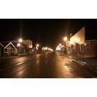
Gadsden: The city of Gadsden at night.
Gadsden: Law Enforcement Officers Memorial at Nocallula Falls
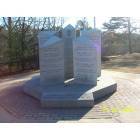
Gadsden: World War Two Veterans Memorial
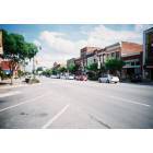
Gadsden: Broad St. Gadsden Alabama
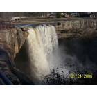
Gadsden: Nocalulla Falls

Gadsden: Under Nocalulla Falls

Gadsden: A Snowy Day

Gadsden: Sunset
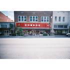
Gadsden: Broad St. Gadsden Alabama

Gadsden: Rainbow under Nocalulla Falls
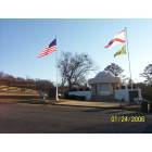
Gadsden
- see
20
more - add
your
Submit your own pictures of this city and show them to the world
- OSM Map
- General Map
- Google Map
- MSN Map
Population change since 2000: -14.5%
 |
| Males: 16,291 | |
| Females: 17,044 |
| Median resident age: | 40.6 years |
| Alabama median age: | 39.6 years |
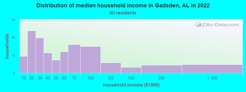
| Gadsden: | $43,440 |
| AL: | $59,674 |
Estimated per capita income in 2022: $24,795 (it was $15,610 in 2000)
Gadsden city income, earnings, and wages data
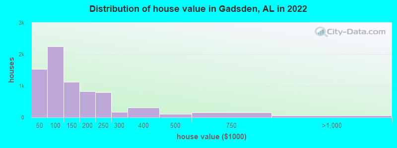
Estimated median house or condo value in 2022: $109,306 (it was $49,000 in 2000)
| Gadsden: | $109,306 |
| AL: | $200,900 |
Mean prices in 2022: all housing units: $158,505; detached houses: $154,332; townhouses or other attached units: $141,157; in 2-unit structures: $95,597; in 3-to-4-unit structures: $127,020; mobile homes: $219,394
Median gross rent in 2022: $781.
(20.5% for White Non-Hispanic residents, 27.8% for Black residents, 42.3% for Hispanic or Latino residents, 42.5% for American Indian residents, 43.4% for other race residents, 31.4% for two or more races residents)
Detailed information about poverty and poor residents in Gadsden, AL


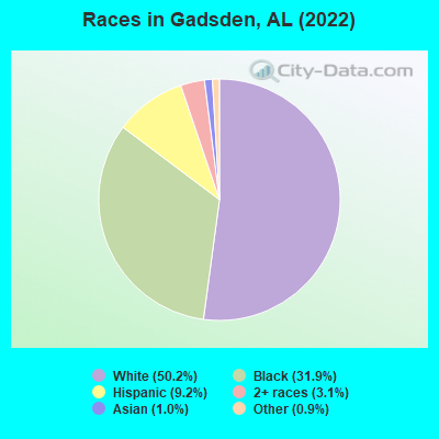
- 16,98150.2%White alone
- 10,77431.9%Black alone
- 3,0969.2%Hispanic
- 1,0553.1%Two or more races
- 3301.0%Asian alone
- 3200.9%Other race alone
- 120.04%American Indian alone
According to our research of Alabama and other state lists, there were 129 registered sex offenders living in Gadsden, Alabama as of April 26, 2024.
The ratio of all residents to sex offenders in Gadsden is 282 to 1.
Type |
2009 |
2010 |
2011 |
2012 |
2013 |
2014 |
2015 |
2016 |
2017 |
2018 |
2019 |
2020 |
2021 |
2022 |
|---|---|---|---|---|---|---|---|---|---|---|---|---|---|---|
| Murders (per 100,000) | 2 (5.5) | 5 (13.6) | 5 (13.5) | 1 (2.7) | 6 (16.4) | 3 (8.2) | 3 (8.3) | 4 (11.1) | 3 (8.4) | 3 (8.5) | 1 (2.9) | 1 (2.9) | 2 (5.8) | 6 (17.9) |
| Rapes (per 100,000) | 41 (112.0) | 30 (81.4) | 25 (67.5) | 33 (89.3) | 47 (128.4) | 31 (85.0) | 32 (88.5) | 27 (75.2) | 23 (64.5) | 24 (68.2) | 21 (60.1) | 14 (40.2) | 21 (60.7) | 15 (44.7) |
| Robberies (per 100,000) | 105 (286.9) | 110 (298.5) | 76 (205.2) | 113 (305.7) | 104 (284.1) | 89 (244.1) | 80 (221.3) | 56 (155.9) | 63 (176.6) | 47 (133.5) | 19 (54.4) | 11 (31.6) | 23 (66.4) | 17 (50.7) |
| Assaults (per 100,000) | 113 (308.8) | 173 (469.4) | 193 (521.2) | 225 (608.7) | 267 (729.3) | 235 (644.6) | 249 (688.8) | 377 (1,049) | 524 (1,469) | 298 (846.5) | 126 (360.5) | 92 (264.4) | 214 (618.3) | 151 (450.5) |
| Burglaries (per 100,000) | 609 (1,664) | 681 (1,848) | 768 (2,074) | 835 (2,259) | 830 (2,267) | 733 (2,011) | 499 (1,380) | 401 (1,116) | 497 (1,394) | 409 (1,162) | 175 (500.8) | 108 (310.4) | 196 (566.3) | 152 (453.4) |
| Thefts (per 100,000) | 1,807 (4,938) | 1,797 (4,876) | 1,967 (5,311) | 1,969 (5,327) | 1,904 (5,201) | 1,879 (5,154) | 2,048 (5,666) | 1,893 (5,269) | 1,914 (5,367) | 1,831 (5,201) | 983 (2,813) | 425 (1,222) | 981 (2,834) | 1,009 (3,010) |
| Auto thefts (per 100,000) | 147 (401.7) | 142 (385.3) | 238 (642.7) | 196 (530.3) | 200 (546.3) | 194 (532.2) | 177 (489.7) | 227 (631.8) | 230 (644.9) | 255 (724.3) | 109 (311.9) | 46 (132.2) | 191 (551.8) | 141 (420.6) |
| Arson (per 100,000) | 0 (0.0) | 2 (5.4) | 18 (48.6) | 21 (56.8) | 14 (38.2) | 31 (85.0) | 8 (22.1) | 1 (2.8) | 16 (44.9) | 30 (85.2) | 0 (0.0) | 0 (0.0) | 8 (23.1) | 13 (38.8) |
| City-Data.com crime index | 594.5 | 630.9 | 655.8 | 704.0 | 777.0 | 676.1 | 654.0 | 678.5 | 779.1 | 628.3 | 314.7 | 181.5 | 400.8 | 362.7 |
The City-Data.com crime index weighs serious crimes and violent crimes more heavily. Higher means more crime, U.S. average is 246.1. It adjusts for the number of visitors and daily workers commuting into cities.
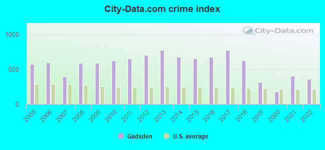
Crime rate in Gadsden detailed stats: murders, rapes, robberies, assaults, burglaries, thefts, arson
Full-time law enforcement employees in 2021, including police officers: 118 (86 officers - 83 male; 3 female).
| Officers per 1,000 residents here: | 2.48 |
| Alabama average: | 2.40 |
 Recent articles from our blog. Our writers, many of them Ph.D. graduates or candidates, create easy-to-read articles on a wide variety of topics.

 | It Was Inevitable in Gadsden (5 replies) |
| Huntsville/Madison Development News (6668 replies) |
| Cool News (2558 replies) |
| Taxes in Alabama (34 replies) |
| New Metro definitions are out (24 replies) |
| What Cities/Metro will explode in the next decade? (149 replies) |
Latest news from Gadsden, AL collected exclusively by city-data.com from local newspapers, TV, and radio stations
Ancestries: American (12.2%), English (6.4%), Irish (3.0%), German (1.8%).
Current Local Time: CST time zone
Elevation: 554 feet
Land area: 36.0 square miles.
Population density: 927 people per square mile (low).
1,133 residents are foreign born (1.9% Latin America, 0.6% Asia, 0.5% Europe).
| This city: | 3.4% |
| Alabama: | 3.5% |
Median real estate property taxes paid for housing units with mortgages in 2022: $708 (0.4%)
Median real estate property taxes paid for housing units with no mortgage in 2022: $382 (0.5%)
Nearest city with pop. 50,000+: Birmingham, AL  (57.1 miles , pop. 242,820).
Nearest city with pop. 1,000,000+: Chicago, IL (549.2 miles , pop. 2,896,016).
Nearest cities:
), ), ), )Latitude: 34.01 N, Longitude: 86.01 W
Daytime population change due to commuting: +11,465 (+33.9%)
Workers who live and work in this city: 9,021 (66.4%)
Area code: 256

Gadsden tourist attractions:
Gadsden, Alabama accommodation & food services, waste management - Economy and Business Data
Single-family new house construction building permits:
- 2022: 19 buildings, average cost: $216,900
- 2018: 16 buildings, average cost: $91,900
- 2017: 12 buildings, average cost: $113,700
- 2015: 8 buildings, average cost: $72,900
- 2014: 11 buildings, average cost: $59,200
- 2013: 12 buildings, average cost: $468,700
- 2012: 13 buildings, average cost: $112,800
- 2011: 9 buildings, average cost: $72,300
- 2010: 16 buildings, average cost: $51,000
- 2009: 29 buildings, average cost: $96,400
- 2008: 35 buildings, average cost: $82,900
- 2007: 28 buildings, average cost: $109,000
- 2006: 17 buildings, average cost: $103,400
- 2005: 23 buildings, average cost: $163,500
- 2004: 19 buildings, average cost: $119,100
- 2003: 30 buildings, average cost: $70,900
- 2002: 22 buildings, average cost: $100,500
- 2001: 12 buildings, average cost: $75,300
- 2000: 12 buildings, average cost: $75,300
- 1999: 12 buildings, average cost: $95,100
- 1998: 25 buildings, average cost: $107,000
- 1997: 15 buildings, average cost: $99,200
| Here: | 3.6% |
| Alabama: | 2.6% |
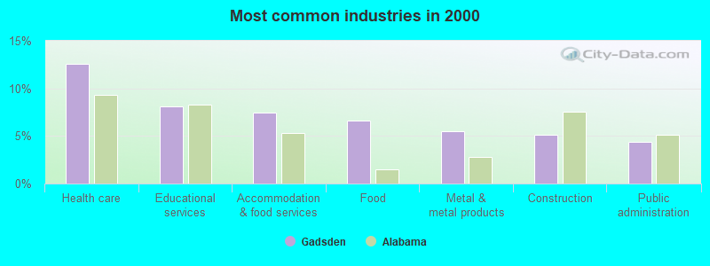
- Health care (12.6%)
- Educational services (8.1%)
- Accommodation & food services (7.5%)
- Food (6.6%)
- Metal & metal products (5.5%)
- Construction (5.1%)
- Public administration (4.4%)
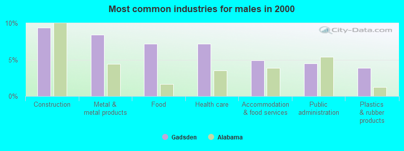
- Construction (9.4%)
- Metal & metal products (8.4%)
- Food (7.1%)
- Health care (7.1%)
- Accommodation & food services (4.9%)
- Public administration (4.5%)
- Plastics & rubber products (3.9%)
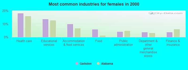
- Health care (18.1%)
- Educational services (13.8%)
- Accommodation & food services (10.1%)
- Food (6.0%)
- Public administration (4.3%)
- Department & other general merchandise stores (4.0%)
- Finance & insurance (3.8%)
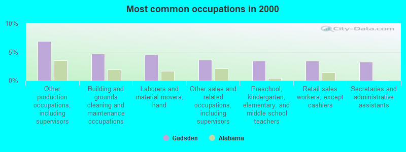
- Other production occupations, including supervisors (6.9%)
- Building and grounds cleaning and maintenance occupations (4.7%)
- Laborers and material movers, hand (4.5%)
- Other sales and related occupations, including supervisors (3.6%)
- Preschool, kindergarten, elementary, and middle school teachers (3.5%)
- Retail sales workers, except cashiers (3.4%)
- Secretaries and administrative assistants (3.3%)

- Other production occupations, including supervisors (8.5%)
- Laborers and material movers, hand (6.3%)
- Building and grounds cleaning and maintenance occupations (5.5%)
- Driver/sales workers and truck drivers (5.0%)
- Electrical equipment mechanics and other installation, maintenance, and repair workers, including supervisors (4.8%)
- Metal workers and plastic workers (4.3%)
- Other sales and related occupations, including supervisors (3.9%)
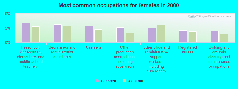
- Preschool, kindergarten, elementary, and middle school teachers (6.7%)
- Secretaries and administrative assistants (6.3%)
- Cashiers (5.8%)
- Other production occupations, including supervisors (5.2%)
- Other office and administrative support workers, including supervisors (4.9%)
- Registered nurses (4.2%)
- Building and grounds cleaning and maintenance occupations (3.9%)
Average climate in Gadsden, Alabama
Based on data reported by over 4,000 weather stations

|
|


(lower is better)
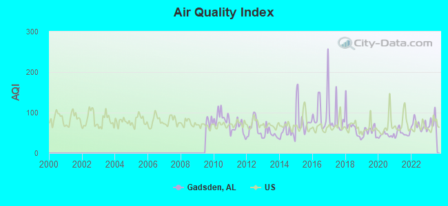
Air Quality Index (AQI) level in 2023 was 74.1. This is about average.
| City: | 74.1 |
| U.S.: | 72.6 |
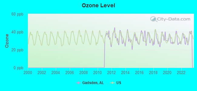
Ozone [ppb] level in 2023 was 35.5. This is about average. Closest monitor was 19.4 miles away from the city center.
| City: | 35.5 |
| U.S.: | 33.3 |
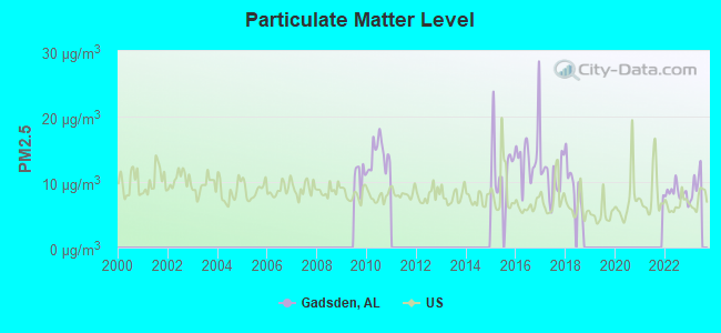
Particulate Matter (PM2.5) [µg/m3] level in 2022 was 8.35. This is about average. Closest monitor was 1.6 miles away from the city center.
| City: | 8.35 |
| U.S.: | 8.11 |
Tornado activity:
Gadsden-area historical tornado activity is slightly above Alabama state average. It is 149% greater than the overall U.S. average.
On 11/24/2001, a category F4 (max. wind speeds 207-260 mph) tornado 16.7 miles away from the Gadsden city center injured 22 people and caused $1 million in damages.
On 3/27/1994, a category F4 tornado 21.6 miles away from the city center killed 22 people and injured 150 people and caused between $5,000,000 and $50,000,000 in damages.
Earthquake activity:
Gadsden-area historical earthquake activity is significantly above Alabama state average. It is 116% greater than the overall U.S. average.On 4/29/2003 at 08:59:39, a magnitude 4.9 (4.4 MB, 4.6 MW, 4.9 LG, Class: Light, Intensity: IV - V) earthquake occurred 39.9 miles away from Gadsden center
On 1/18/1999 at 07:00:53, a magnitude 4.8 (4.8 MB, 4.0 LG, Depth: 0.6 mi) earthquake occurred 82.9 miles away from the city center
On 4/29/2003 at 08:59:39, a magnitude 4.6 (4.6 MW, Depth: 12.3 mi) earthquake occurred 39.9 miles away from the city center
On 6/24/1975 at 11:11:36, a magnitude 4.5 (4.5 MB) earthquake occurred 107.0 miles away from the city center
On 8/2/1974 at 08:52:09, a magnitude 4.9 (4.3 MB, 4.9 LG) earthquake occurred 202.3 miles away from Gadsden center
On 11/30/1973 at 07:48:41, a magnitude 4.7 (4.7 MB, 4.6 ML) earthquake occurred 169.7 miles away from the city center
Magnitude types: regional Lg-wave magnitude (LG), body-wave magnitude (MB), local magnitude (ML), moment magnitude (MW)
Natural disasters:
The number of natural disasters in Etowah County (25) is a lot greater than the US average (15).Major Disasters (Presidential) Declared: 16
Emergencies Declared: 5
Causes of natural disasters: Storms: 14, Tornadoes: 11, Floods: 10, Hurricanes: 4, Winds: 4, Winter Storms: 2, Drought: 1, Fire: 1, Freeze: 1, Snowfall: 1, Other: 1 (Note: some incidents may be assigned to more than one category).
Hospitals in Gadsden:
- GADSDEN REGIONAL MEDICAL CENTER (Proprietary, provides emergency services, 1007 GOODYEAR AVENUE)
- GADSDEN SURGERY CENTER INC (418 SOUTH FIFTH STREET)
- MOUNTAIN VIEW HOSPITAL (3201 SCENIC HIGHWAY)
- RIVERVIEW REGIONAL MEDICAL CENTER (Proprietary, 600 SOUTH THIRD STREET)
- SOUTHERNCARE GADSDEN (505 LAKE STREET)
Nursing Homes in Gadsden:
- GADSDEN HEALTH AND REHAB CENTER (1945 DAVIS DRIVE)
- MCGUFFEY HEALTH AND REHABILITATION CENTER (2301 RAINBOW DRIVE)
- MCGUFFEY HEALTH CARE CENTER (2301 RAINBOW DRIVE)
- NORTHSIDE HEALTH CARE (700 HUTCHINS AVENUE)
Dialysis Facilities in Gadsden:
Home Health Centers in Gadsden:
Airports and heliports located in Gadsden:
- Northeast Alabama Regional Airport (GAD) (Runways: 2, Air Taxi Ops: 1,200, Itinerant Ops: 17,520, Local Ops: 4,736, Military Ops: 430)
- Gadsden Regional Medical Center Heliport (0AL7)
College/University in Gadsden:
Other colleges/universities with over 2000 students near Gadsden:
- Snead State Community College (about 17 miles; Boaz, AL; Full-time enrollment: 2,023)
- Jacksonville State University (about 20 miles; Jacksonville, AL; FT enrollment: 7,566)
- Northeast Alabama Community College (about 38 miles; Rainsville, AL; FT enrollment: 2,409)
- George C Wallace State Community College-Hanceville (about 45 miles; Hanceville, AL; FT enrollment: 4,486)
- Jefferson State Community College (about 48 miles; Birmingham, AL; FT enrollment: 6,041)
- Georgia Highlands College (about 48 miles; Rome, GA; FT enrollment: 4,071)
- Georgia Northwestern Technical College (about 51 miles; Rome, GA; FT enrollment: 4,629)
Library in Gadsden:
Points of interest:
Notable locations in Gadsden: Airport Industrial Park (A), Louisville and Nashville Depot (B), Tuckahoe Golf Course (C), Austin R Meadows Library (D), Etowah County Courthouse (E), East Gadsden Community Center (F), Wallace Hall (G), Fowler Hall (H), Allen Hall (I), Browder Hall (J), Naylor Hall (K), Beck Field House (L), Bevill Hall (M), Helderman Hall (N), Gadsen Etowah Emergency Medical Services (O), Gadsden Fire Department Station 1 (P), Gadsden Fire Department Station 4 (Q), Gadsden Fire Department Station 9 (R), Gadsden Fire Department Station 7 (S), Gadsden Fire Department Station 5 (T). Display/hide their locations on the map
Shopping Centers: Genie Drew Village Shopping Center (1), Gadsden Mall Shopping Center (2), Agricola Shopping Center (3). Display/hide their locations on the map
Churches in Gadsden include: Paden Church (A), McCauley Chapel Methodist Church (B), Saint John Christian Methodist Episcopal Church (C), Word of Life Church (D), West End Baptist Church (E), Wayfaring Church of God (F), Ward Memorial Presbyterian Church (G), Walnut Park Presbyterian Church (H), Walnut Park Methodist Church (I). Display/hide their locations on the map
Cemeteries: Crestwood Memorial Cemetery (1), Hughes Cemetery (2), Forrest Cemetery (3), Alabama City Cemetery (4), Beth Israel Cemetery (5), Tillison Cemetery (6), McCartney Cemetery (7). Display/hide their locations on the map
Reservoirs: Goodyear Lake (A), Clayton Fish Pond (B). Display/hide their locations on the map
Streams, rivers, and creeks: Horton Creek (A), Hughes Spring Branch (B), Big Wills Creek (C), Black Creek (D), Little Wills Creek (E), Town Creek (F). Display/hide their locations on the map
Parks in Gadsden include: Banks Park (1), Central Recreation Area (2), Gadsden Kiwanis Park (3), Gadsden Moragne Park (4), Noccalula Park (5), North Gadsden Park (6), Sequoyah Park (7). Display/hide their locations on the map
Tourist attractions: Imagination Place (Museums; 501 Broad Street) (1), Gadsden Cultural Arts Foundation (Museums; 501 Broad Street) (2), Mary G Hardin Center for Cultural Arts (Museums; 501 Broad Street) (3), Cycle World Honda Kawasaki Yamaha Sea-Doo (Tours & Charters; 1701 West Meighan Boulevard) (4). Display/hide their approximate locations on the map
Hotels: Best Western Gadsden Hotel and (205 Enterprise Drive) (1), Redwood Inn Motel (201 North Hood Avenue) (2), Budget Inn (2704 West Meighan Boulevard) (3), Motel 6 (1600 Rainbow Drive) (4), Super 8 Motel Gadsden (2110 Rainbow Drive) (5), Holiday Host (2464 East Meighan Boulevard) (6), Hampton Inn Gadsden (129 River Road) (7), Days Inn (1612 West Grand Avenue) (8), Town House Motel (3101 East Meighan Boulevard) (9). Display/hide their approximate locations on the map
Courts: Debtors Court (310 South 3rd Street Suite A) (1), Alabama Court Services Inc (120 Chestnut Street) (2), Council Of Aging Campbell Court (100 Campbell Court) (3), Housing Authority-Greater Gadsden - Campbell Court Rental Office (100 Campbell Court) (4), Rainbow City City - Court Clerk (3700 Rainbow Drive) (5), Medical Society Of Etowah County (1 Commerce Square) (6), U S Government - District Court Judge (600 Broad Street) (7), Court Security Main Entrance Gadsde Federal Bldg (600 Broad Street) (8). Display/hide their approximate locations on the map
Birthplace of: Roy Moore - Judge, Milton K. Cummings - Businessperson, Bill Green (basketball) - Basketball player, Charles Clyde Ebbets - Photographer, Dre Kirkpatrick - Football defensive back, Edgar Huff - Marine, James Allen (U.S. senator) - Politician, Mathew Knowles - Record producer, Jerrell Harris - Football linebacker, La'Donte Harris - Football player and coach.
Drinking water stations with addresses in Gadsden and their reported violations in the past:
GADSDEN WATER WORKS AND SEWER BOARD (Population served: 46,551, Surface water):Past monitoring violations:HIGHLAND WATER AUTHORITY (Address: 3071 TABOR RD , Population served: 5,271, Purch surface water):
- Monitoring and Reporting (DBP) - Between JAN-2004 and MAR-2007, Contaminant: Total Haloacetic Acids (HAA5). Follow-up actions: St Formal NOV issued (MAY-24-2007), St Compliance achieved (MAR-31-2008)
- Monitoring and Reporting (DBP) - Between JAN-2004 and MAR-2007, Contaminant: TTHM. Follow-up actions: St Formal NOV issued (MAY-24-2007), St Compliance achieved (MAR-31-2008)
- 21 regular monitoring violations
Past monitoring violations:NORTHEAST ETOWAH COUNTY WATER CO-OP (Address: 3733 US HWY 411 , Population served: 4,110, Purch surface water):
- Monitoring and Reporting (DBP) - Between NOV-27-2013 and FEB-27-2014, Contaminant: TTHM. Follow-up actions: St Violation/Reminder Notice (JUL-23-2013), St Public Notif requested (JUL-23-2013)
- Monitoring and Reporting (DBP) - Between NOV-27-2013 and FEB-27-2014, Contaminant: Total Haloacetic Acids (HAA5). Follow-up actions: St Violation/Reminder Notice (JUL-23-2013), St Public Notif requested (JUL-23-2013)
- Monitoring and Reporting (DBP) - Between AUG-30-2013 and NOV-26-2013, Contaminant: TTHM. Follow-up actions: St Public Notif requested (JUL-23-2013), St Violation/Reminder Notice (JUL-23-2013), St Compliance achieved (APR-02-2014)
- Monitoring and Reporting (DBP) - Between AUG-30-2013 and NOV-26-2013, Contaminant: Total Haloacetic Acids (HAA5). Follow-up actions: St Public Notif requested (JUL-23-2013), St Violation/Reminder Notice (JUL-23-2013), St Compliance achieved (APR-02-2014)
- Monitoring and Reporting (DBP) - Between JUN-2013 and AUG-2013, Contaminant: Total Haloacetic Acids (HAA5). Follow-up actions: St Public Notif requested (JUL-23-2013), St Violation/Reminder Notice (JUL-23-2013), St Compliance achieved (JAN-22-2014)
- 3 other older monitoring violations
Past health violations:TILLISON BEND WATER AUTHORITY (Population served: 1,035, Purch surface water):
- MCL, Average - Between OCT-2012 and DEC-2012, Contaminant: TTHM. Follow-up actions: St Public Notif requested (FEB-06-2013), St Violation/Reminder Notice (FEB-06-2013), St Public Notif received (MAR-18-2013), St Compliance achieved (APR-01-2013)
- MCL, Average - Between JAN-2007 and MAR-2007, Contaminant: TTHM. Follow-up actions: St Public Notif requested (MAY-09-2007), St Violation/Reminder Notice (MAY-09-2007), St Site Visit (enforcement) (MAY-15-2007), St Public Notif received (JUN-11-2007), St AO (w/o penalty) issued (FEB-25-2008), St Compliance achieved (SEP-01-2008)
- MCL, Average - Between JAN-2007 and MAR-2007, Contaminant: Total Haloacetic Acids (HAA5). Follow-up actions: St Public Notif requested (MAY-09-2007), St Violation/Reminder Notice (MAY-09-2007), St Site Visit (enforcement) (MAY-15-2007), St Public Notif received (JUN-11-2007), St AO (w/o penalty) issued (FEB-25-2008), St Compliance achieved (SEP-01-2008)
- MCL, Average - Between OCT-2006 and DEC-2006, Contaminant: Total Haloacetic Acids (HAA5). Follow-up actions: St Public Notif requested (JAN-24-2007), St Violation/Reminder Notice (JAN-24-2007), St Site Visit (enforcement) (FEB-01-2007), St Public Notif received (FEB-26-2007), St AO (w/o penalty) issued (FEB-25-2008), St Compliance achieved (SEP-01-2008)
- MCL, Average - Between OCT-2006 and DEC-2006, Contaminant: TTHM. Follow-up actions: St Public Notif requested (JAN-24-2007), St Violation/Reminder Notice (JAN-24-2007), St Site Visit (enforcement) (FEB-01-2007), St Public Notif received (FEB-26-2007), St AO (w/o penalty) issued (FEB-25-2008), St Compliance achieved (SEP-01-2008)
Past health violations:Past monitoring violations:
- MCL, Average - Between APR-2010 and JUN-2010, Contaminant: Total Haloacetic Acids (HAA5). Follow-up actions: St Public Notif requested (JUL-12-2010), St Violation/Reminder Notice (JUL-12-2010), St Public Notif received (AUG-12-2010), St AO (w/o penalty) issued (NOV-04-2010), St Compliance achieved (JUN-15-2011)
- MCL, Average - Between JAN-2010 and MAR-2010, Contaminant: Total Haloacetic Acids (HAA5). Follow-up actions: St Public Notif requested (APR-12-2010), St Violation/Reminder Notice (APR-12-2010), St Site Visit (enforcement) (MAY-07-2010), St Public Notif received (MAY-27-2010), St AO (w/o penalty) issued (NOV-04-2010), St Compliance achieved (JUN-15-2011)
- MCL, Average - Between JUL-2007 and SEP-2007, Contaminant: TTHM. Follow-up actions: St Public Notif requested (NOV-16-2007), St Violation/Reminder Notice (NOV-16-2007), St Public Notif received (DEC-20-2007), St AO (w/o penalty) issued (FEB-26-2008), St Compliance achieved (SEP-01-2008)
- MCL, Average - Between APR-2007 and JUN-2007, Contaminant: TTHM. Follow-up actions: St Public Notif requested (AUG-17-2007), St Violation/Reminder Notice (AUG-17-2007), St Public Notif received (SEP-21-2007), St AO (w/o penalty) issued (FEB-26-2008), St Compliance achieved (SEP-01-2008)
- MCL, Average - Between JAN-2007 and MAR-2007, Contaminant: TTHM. Follow-up actions: St AO (w/o penalty) issued (FEB-26-2008), St Compliance achieved (SEP-01-2008)
- MCL, Average - Between OCT-2006 and DEC-2006, Contaminant: TTHM. Follow-up actions: St Public Notif requested (JAN-25-2007), St Violation/Reminder Notice (JAN-25-2007), St Site Visit (enforcement) (JAN-31-2007), St Public Notif received (MAR-01-2007), St AO (w/o penalty) issued (FEB-26-2008), St Compliance achieved (SEP-01-2008)
- Monitoring and Reporting (DBP) - Between DEC-06-2013 and MAR-06-2014, Contaminant: TTHM. Follow-up actions: St Violation/Reminder Notice (JUL-23-2013), St Public Notif requested (JUL-23-2013)
- Monitoring and Reporting (DBP) - Between DEC-06-2013 and MAR-06-2014, Contaminant: Total Haloacetic Acids (HAA5). Follow-up actions: St Violation/Reminder Notice (JUL-23-2013), St Public Notif requested (JUL-23-2013)
- Monitoring and Reporting (DBP) - Between SEP-06-2013 and DEC-05-2013, Contaminant: TTHM. Follow-up actions: St Public Notif requested (JUL-23-2013), St Violation/Reminder Notice (JUL-23-2013), St Compliance achieved (2 times from JAN-10-2014 to APR-10-2014)
- Monitoring and Reporting (DBP) - Between SEP-06-2013 and DEC-05-2013, Contaminant: Total Haloacetic Acids (HAA5). Follow-up actions: St Public Notif requested (JUL-23-2013), St Violation/Reminder Notice (JUL-23-2013), St Compliance achieved (2 times from JAN-10-2014 to APR-10-2014)
- Monitoring and Reporting (DBP) - Between JUN-01-2013 and SEP-05-2013, Contaminant: Total Haloacetic Acids (HAA5). Follow-up actions: St Violation/Reminder Notice (JUL-23-2013), St Public Notif requested (JUL-23-2013)
- One routine major monitoring violation
- 5 other older monitoring violations
| This city: | 2.3 people |
| Alabama: | 2.5 people |
| This city: | 60.5% |
| Whole state: | 67.8% |
| This city: | 5.1% |
| Whole state: | 4.7% |
Likely homosexual households (counted as self-reported same-sex unmarried-partner households)
- Lesbian couples: 0.3% of all households
- Gay men: 0.2% of all households
People in group quarters in Gadsden in 2010:
- 784 people in local jails and other municipal confinement facilities
- 380 people in nursing facilities/skilled-nursing facilities
- 341 people in college/university student housing
- 119 people in other noninstitutional facilities
- 61 people in group homes intended for adults
- 28 people in residential treatment centers for adults
- 14 people in emergency and transitional shelters (with sleeping facilities) for people experiencing homelessness
- 13 people in residential treatment centers for juveniles (non-correctional)
- 12 people in group homes for juveniles (non-correctional)
People in group quarters in Gadsden in 2000:
- 454 people in nursing homes
- 399 people in local jails and other confinement facilities (including police lockups)
- 279 people in job corps and vocational training facilities
- 115 people in other noninstitutional group quarters
- 92 people in college dormitories (includes college quarters off campus)
- 34 people in homes or halfway houses for drug/alcohol abuse
- 20 people in homes for the mentally ill
- 13 people in training schools for juvenile delinquents
- 9 people in hospitals or wards for drug/alcohol abuse
- 9 people in homes for the mentally retarded
- 3 people in hospitals/wards and hospices for chronically ill
- 3 people in hospices or homes for chronically ill
- 3 people in agriculture workers' dormitories on farms
Banks with most branches in Gadsden (2011 data):
- Regions Bank: Gadsden Main Office Branch, Eastside Branch, Clubview Branch. Info updated 2011/02/24: Bank assets: $123,368.2 mil, Deposits: $98,301.3 mil, headquarters in Birmingham, AL, positive income, Commercial Lending Specialization, 1778 total offices, Holding Company: Regions Financial Corporation
- Compass Bank: Gadsden Main Branch at 601 Broad Street, branch established on 1964/12/21; Gadsden East Branch at 460 George Wallace Drive, branch established on 1929/10/11. Info updated 2011/02/24: Bank assets: $63,107.0 mil, Deposits: $46,232.4 mil, headquarters in Birmingham, AL, negative income in the last year, Commercial Lending Specialization, 720 total offices, Holding Company: Banco Bilbao Vizcaya Argentaria, S.A.
- The Exchange Bank of Alabama: Gadsden Branch at 230 North Third Street, branch established on 1980/03/03; Noccalula Village Branch at 1321a Noccalula Road, branch established on 1996/12/07. Info updated 2011/02/24: Bank assets: $230.7 mil, Deposits: $202.5 mil, headquarters in Altoona, AL, negative income in the last year, Commercial Lending Specialization, 5 total offices, Holding Company: Gadsden Corporation, The
- Wells Fargo Bank, National Association: Gadsden Main Branch at 250 South 7th Street, branch established on 1982/01/02; Alabama City Office at 201 Wall Street, branch established on 1906/07/01. Info updated 2011/04/05: Bank assets: $1,161,490.0 mil, Deposits: $905,653.0 mil, headquarters in Sioux Falls, SD, positive income, 6395 total offices, Holding Company: Wells Fargo & Company
- Branch Banking and Trust Company: Gadsden Branch at 401 Broad Street, branch established on 1998/04/01. Info updated 2010/03/29: Bank assets: $168,867.6 mil, Deposits: $127,549.5 mil, headquarters in Winston Salem, NC, positive income, Commercial Lending Specialization, 1793 total offices, Holding Company: Bb&T Corporation
- Generations Bank: Gadsden Branch at 400 West Meighan Boulevard, branch established on 2009/03/23. Info updated 2011/02/24: Bank assets: $64.1 mil, Deposits: $56.4 mil, headquarters in Centre, AL, positive income, Commercial Lending Specialization, 3 total offices, Holding Company: Altrust Financial Services, Inc.
- Peoples Independent Bank: Hokes Bluff Branch at 5690 Us Highway 278 East, branch established on 2006/08/01. Info updated 2011/02/24: Bank assets: $171.4 mil, Deposits: $154.7 mil, headquarters in Boaz, AL, positive income, Commercial Lending Specialization, 5 total offices, Holding Company: Peoples Independent Bancshares, Inc.
- The Southern Bank Company: at 221 S Sixth St, branch established on 1936/06/01. Info updated 2011/02/24: Bank assets: $101.8 mil, Deposits: $74.6 mil, local headquarters, negative income in the last year, Mortgage Lending Specialization, 4 total offices, Holding Company: Southern Banc Company, Inc., The
- Keystone Bank: Gadsden Branch at 244 South 3rd Street, branch established on 2007/10/01. Info updated 2007/03/05: Bank assets: $198.5 mil, Deposits: $170.8 mil, headquarters in Auburn, AL, positive income, Commercial Lending Specialization, 2 total offices
For population 15 years and over in Gadsden:
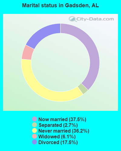
- Never married: 36.2%
- Now married: 37.5%
- Separated: 2.7%
- Widowed: 6.1%
- Divorced: 17.5%
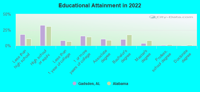
For population 25 years and over in Gadsden:
- High school or higher: 83.5%
- Bachelor's degree or higher: 15.7%
- Graduate or professional degree: 5.6%
- Unemployed: 9.0%
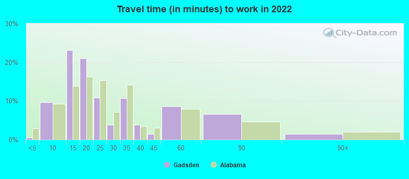
- Mean travel time to work (commute): 18.4 minutes
| Here: | 10.4 |
| Alabama average: | 11.5 |
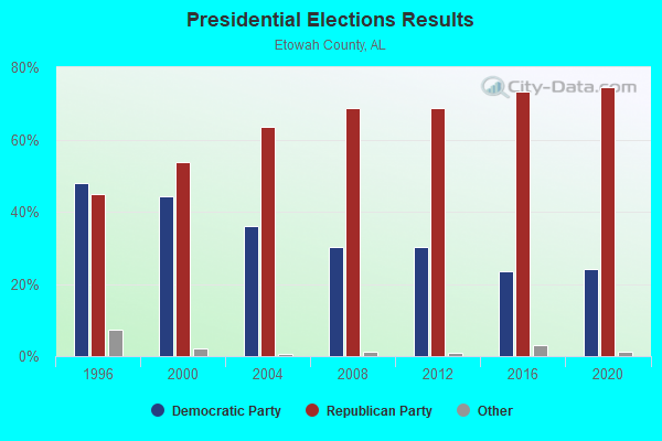
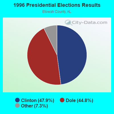
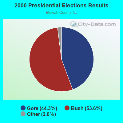
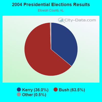
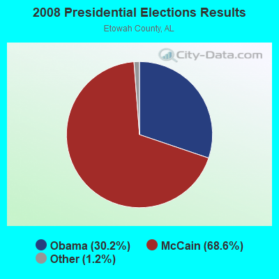

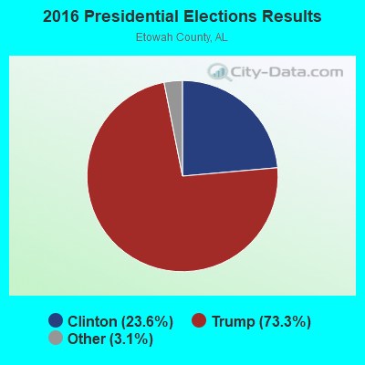
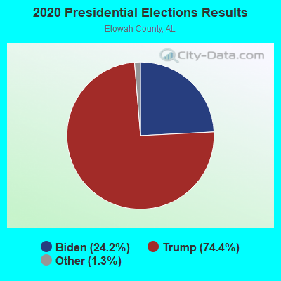
Graphs represent county-level data. Detailed 2008 Election Results
Religion statistics for Gadsden, AL (based on Etowah County data)
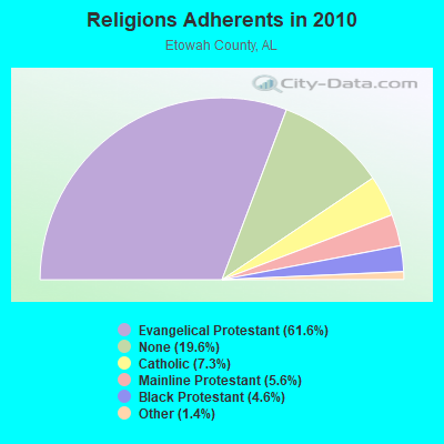
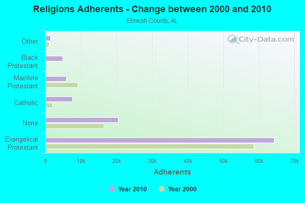
| Religion | Adherents | Congregations |
|---|---|---|
| Evangelical Protestant | 64,316 | 193 |
| Catholic | 7,624 | 1 |
| Mainline Protestant | 5,816 | 35 |
| Black Protestant | 4,813 | 21 |
| Other | 1,437 | 6 |
| None | 20,424 | - |
Food Environment Statistics:
| Etowah County: | 2.43 / 10,000 pop. |
| Alabama: | 1.89 / 10,000 pop. |
| Etowah County: | 0.78 / 10,000 pop. |
| Alabama: | 0.65 / 10,000 pop. |
| Etowah County: | 6.21 / 10,000 pop. |
| State: | 6.32 / 10,000 pop. |
| Here: | 4.95 / 10,000 pop. |
| Alabama: | 5.75 / 10,000 pop. |
| Etowah County: | 10.7% |
| Alabama: | 11.8% |
| Etowah County: | 32.5% |
| Alabama: | 31.7% |
| Etowah County: | 20.2% |
| State: | 13.5% |
Health and Nutrition:
| Gadsden: | 47.7% |
| Alabama: | 49.0% |
| Gadsden: | 43.0% |
| State: | 45.7% |
| Gadsden: | 29.1 |
| State: | 28.9 |
| This city: | 21.4% |
| Alabama: | 20.7% |
| Gadsden: | 13.0% |
| Alabama: | 11.0% |
| This city: | 6.8 |
| Alabama: | 6.8 |
| Here: | 34.3% |
| Alabama: | 34.4% |
| Gadsden: | 51.9% |
| State: | 55.2% |
| This city: | 77.2% |
| Alabama: | 79.3% |
More about Health and Nutrition of Gadsden, AL Residents
| Local government employment and payroll (March 2022) | |||||
| Function | Full-time employees | Monthly full-time payroll | Average yearly full-time wage | Part-time employees | Monthly part-time payroll |
|---|---|---|---|---|---|
| Firefighters | 115 | $509,122 | $53,126 | 0 | $0 |
| Police Protection - Officers | 86 | $423,013 | $59,025 | 0 | $0 |
| Parks and Recreation | 66 | $174,295 | $31,690 | 80 | $63,966 |
| Other and Unallocable | 63 | $297,888 | $56,741 | 6 | $5,553 |
| Streets and Highways | 57 | $147,604 | $31,075 | 14 | $12,121 |
| Water Supply | 40 | $279,988 | $83,996 | 0 | $0 |
| Solid Waste Management | 32 | $83,363 | $31,261 | 3 | $3,578 |
| Police - Other | 27 | $93,819 | $41,697 | 1 | $399 |
| Other Government Administration | 20 | $86,871 | $52,123 | 12 | $13,153 |
| Local Libraries | 18 | $53,196 | $35,464 | 9 | $6,745 |
| Financial Administration | 13 | $54,786 | $50,572 | 0 | $0 |
| Sewerage | 12 | $81,574 | $81,574 | 0 | $0 |
| Transit | 11 | $29,911 | $32,630 | 17 | $22,856 |
| Judicial and Legal | 8 | $29,406 | $44,109 | 7 | $7,338 |
| Health | 4 | $10,921 | $32,763 | 0 | $0 |
| Housing and Community Development (Local) | 2 | $7,143 | $42,858 | 1 | $1,116 |
| Fire - Other | 2 | $5,558 | $33,348 | 0 | $0 |
| Totals for Government | 576 | $2,368,458 | $49,343 | 150 | $136,825 |
Gadsden government finances - Expenditure in 2021 (per resident):
- Construction - Sewerage: $1,148,000 ($34.44)
Housing and Community Development: $833,000 ($24.99)
General - Other: $187,000 ($5.61)
Parks and Recreation: $105,000 ($3.15)
Water Utilities: $77,000 ($2.31)
- Current Operations - Water Utilities: $13,214,000 ($396.40)
Police Protection: $10,945,000 ($328.33)
Local Fire Protection: $9,877,000 ($296.30)
General - Other: $8,252,000 ($247.55)
Parks and Recreation: $4,690,000 ($140.69)
Solid Waste Management: $3,680,000 ($110.39)
Transit Utilities: $3,182,000 ($95.46)
Regular Highways: $3,120,000 ($93.60)
Central Staff Services: $1,938,000 ($58.14)
Judicial and Legal Services: $1,860,000 ($55.80)
General Public Buildings: $1,555,000 ($46.65)
Libraries: $1,224,000 ($36.72)
Financial Administration: $1,114,000 ($33.42)
Protective Inspection and Regulation - Other: $699,000 ($20.97)
Miscellaneous Commercial Activities - Other: $583,000 ($17.49)
Housing and Community Development: $517,000 ($15.51)
- General - Interest on Debt: $2,149,000 ($64.47)
- Other Capital Outlay - General - Other: $1,096,000 ($32.88)
Water Utilities: $317,000 ($9.51)
Housing and Community Development: $156,000 ($4.68)
Parks and Recreation: $95,000 ($2.85)
Police Protection: $42,000 ($1.26)
Miscellaneous Commercial Activities - Other: $21,000 ($0.63)
Local Fire Protection: $20,000 ($0.60)
Regular Highways: $9,000 ($0.27)
Judicial and Legal Services: $6,000 ($0.18)
- Total Salaries and Wages: $29,405,000 ($882.11)
- Water Utilities - Interest on Debt: $1,258,000 ($37.74)
Gadsden government finances - Revenue in 2021 (per resident):
- Charges - Sewerage: $7,668,000 ($230.03)
Solid Waste Management: $2,468,000 ($74.04)
Parks and Recreation: $1,799,000 ($53.97)
Air Transportation: $397,000 ($11.91)
Other: $357,000 ($10.71)
Miscellaneous Commercial Activities: $60,000 ($1.80)
- Federal Intergovernmental - Housing and Community Development: $1,490,000 ($44.70)
Other: $902,000 ($27.06)
Transit Utilities: $596,000 ($17.88)
- Local Intergovernmental - Highways: $341,000 ($10.23)
Other: $252,000 ($7.56)
General Local Government Support: $239,000 ($7.17)
- Miscellaneous - General Revenue - Other: $824,000 ($24.72)
Fines and Forfeits: $773,000 ($23.19)
Interest Earnings: $641,000 ($19.23)
Sale of Property: $53,000 ($1.59)
Rents: $44,000 ($1.32)
- Revenue - Water Utilities: $10,040,000 ($301.18)
- State Intergovernmental - Highways: $586,000 ($17.58)
General Local Government Support: $213,000 ($6.39)
Other: $164,000 ($4.92)
Transit Utilities: $162,000 ($4.86)
- Tax - General Sales and Gross Receipts: $21,640,000 ($649.17)
Individual Income: $15,617,000 ($468.49)
Occupation and Business License - Other: $6,756,000 ($202.67)
Property: $2,942,000 ($88.26)
Other: $1,920,000 ($57.60)
Other Selective Sales: $622,000 ($18.66)
Other License: $599,000 ($17.97)
Motor Fuels Sales: $556,000 ($16.68)
Tobacco Products Sales: $378,000 ($11.34)
Alcoholic Beverage Sales: $220,000 ($6.60)
Gadsden government finances - Debt in 2021 (per resident):
- Long Term Debt - Beginning Outstanding - Unspecified Public Purpose: $88,097,000 ($2642.78)
Outstanding Unspecified Public Purpose: $82,816,000 ($2484.36)
Retired Unspecified Public Purpose: $5,280,000 ($158.39)
Beginning Outstanding - Public Debt for Private Purpose: $2,620,000 ($78.60)
Outstanding Nonguaranteed - Industrial Revenue: $2,340,000 ($70.20)
Retired Nonguaranteed - Public Debt for Private Purpose: $280,000 ($8.40)
Gadsden government finances - Cash and Securities in 2021 (per resident):
- Bond Funds - Cash and Securities: $2,350,000 ($70.50)
- Other Funds - Cash and Securities: $32,392,000 ($971.71)
- Sinking Funds - Cash and Securities: $2,340,000 ($70.20)
| Businesses in Gadsden, AL | ||||
| Name | Count | Name | Count | |
|---|---|---|---|---|
| ALDI | 1 | Little Caesars Pizza | 2 | |
| AT&T | 2 | Lowe's | 1 | |
| Academy Sports + Outdoors | 1 | Marriott | 1 | |
| Advance Auto Parts | 2 | Maurices | 1 | |
| Aeropostale | 1 | McDonald's | 2 | |
| American Eagle Outfitters | 1 | Motel 6 | 1 | |
| Applebee's | 1 | New Balance | 2 | |
| Arby's | 2 | Nike | 11 | |
| AutoZone | 2 | Nissan | 1 | |
| Bath & Body Works | 1 | OfficeMax | 1 | |
| Best Western | 1 | Old Navy | 1 | |
| Blockbuster | 1 | Papa John's Pizza | 1 | |
| Burger King | 1 | Payless | 1 | |
| CVS | 2 | Penske | 1 | |
| Chevrolet | 1 | Pizza Hut | 2 | |
| Chick-Fil-A | 2 | Popeyes | 1 | |
| Church's Chicken | 1 | RadioShack | 1 | |
| Comfort Suites | 1 | Rodeway Inn | 1 | |
| Cracker Barrel | 1 | Ruby Tuesday | 1 | |
| Dairy Queen | 1 | Rue21 | 1 | |
| Days Inn | 1 | SAS Shoes | 1 | |
| Domino's Pizza | 1 | SONIC Drive-In | 2 | |
| FedEx | 7 | Sears | 2 | |
| Finish Line | 1 | Spencer Gifts | 1 | |
| Ford | 1 | Subway | 5 | |
| GNC | 1 | Super 8 | 1 | |
| GameStop | 1 | T-Mobile | 3 | |
| Gap | 1 | T.J.Maxx | 1 | |
| Goodwill | 4 | Taco Bell | 1 | |
| H&R Block | 3 | U-Haul | 4 | |
| Hilton | 2 | UPS | 13 | |
| Hobby Lobby | 1 | Vans | 1 | |
| Holiday Inn | 1 | Verizon Wireless | 1 | |
| Honda | 1 | Victoria's Secret | 1 | |
| JCPenney | 1 | Waffle House | 2 | |
| JoS. A. Bank | 1 | Walgreens | 1 | |
| Jones New York | 1 | Walmart | 1 | |
| Justice | 1 | Wendy's | 1 | |
| KFC | 1 | YMCA | 1 | |
| Kmart | 1 | |||
Strongest AM radio stations in Gadsden:
- WAAX (570 AM; 5 kW; GADSDEN, AL; Owner: CAPSTAR TX LIMITED PARTNERSHIP)
- WJBY (930 AM; 5 kW; RAINBOW CITY, AL; Owner: GADSDEN BROADCASTING COMPANY, INC.)
- WMGJ (1240 AM; 1 kW; GADSDEN, AL; Owner: FLOYD L. DONALD BROADCASTING CO. INC)
- WGAD (1350 AM; 5 kW; GADSDEN, AL; Owner: DEKALB COUNTY COMMUNITY RADIO, INC.)
- WNSI (810 AM; 50 kW; JACKSONVILLE, AL; Owner: UNITED BROADCASTING NETWORK, INC.)
- WDJC (850 AM; 50 kW; BIRMINGHAM, AL; Owner: KIMTRON, INC.)
- WKNG (1060 AM; daytime; 50 kW; TALLAPOOSA, GA; Owner: WKNG, INC.)
- WJOX (690 AM; 50 kW; BIRMINGHAM, AL; Owner: CITADEL BROADCASTING COMPANY)
- WAPI (1070 AM; 50 kW; BIRMINGHAM, AL; Owner: CITADEL BROADCASTING COMPANY)
- WWAM (820 AM; daytime; 50 kW; JASPER, TN; Owner: SHELTON BROADCASTING SYSTEM)
- WGST (640 AM; 50 kW; ATLANTA, GA; Owner: CITICASTERS LICENSES, L.P.)
- WLOR (1550 AM; 50 kW; HUNTSVILLE, AL; Owner: BCA RADIO, LLC)
- WFTD (1080 AM; daytime; 50 kW; MARIETTA, GA; Owner: PRIETO ENTERPRISES, INC.)
Strongest FM radio stations in Gadsden:
- WSGN (91.5 FM; GADSDEN, AL; Owner: GADSDEN STATE COMMUNITY COLLEGE)
- WQSB (105.1 FM; ALBERTVILLE, AL; Owner: SAND MOUNTAIN BROADCASTING SERVICE, INC.)
- WTBB (89.9 FM; GADSDEN, AL; Owner: TRINITY CHRISTIAN ACADEMY)
- WGMZ (93.1 FM; GLENCOE, AL; Owner: CAPSTAR TX LIMITED PARTNERSHIP)
- WKXX (102.9 FM; ATTALLA, AL; Owner: BROADCAST MEDIA LLC)
- WRHY (105.9 FM; CENTRE, AL; Owner: WILLIAMS COMMUNICATIONS, INC.)
- WLJS-FM (91.9 FM; JACKSONVILLE, AL; Owner: BD. OF TRUSTEES/JACKSONVILLE STATE UNIVERSITY)
- WTBJ (91.3 FM; OXFORD, AL; Owner: TRINITY CHRISTIAN ACADEMY)
- W269AN (101.7 FM; GADSDEN, AL; Owner: JOHN S. LA TOUR/J & J B/C)
- WVOK-FM (97.9 FM; OXFORD, AL; Owner: WOODARD BROADCASTING CO. INC.)
- WRAX (107.7 FM; BIRMINGHAM, AL; Owner: CITADEL BROADCASTING COMPANY)
- WYDE-FM (101.1 FM; CULLMAN, AL; Owner: KIMTRON, INC.)
- WGRW (90.7 FM; ANNISTON, AL; Owner: WORD WORKS, INC.)
- W269AX (101.7 FM; ANNISTON, AL; Owner: BIBLE BROADCASTING NETWORK, INC.)
- WJCK (88.3 FM; PIEDMONT, AL; Owner: IMMANUEL BROADCASTING NETWORK, INC.)
- WTWX-FM (95.9 FM; GUNTERSVILLE, AL; Owner: GUNTERSVILLE BROADCASTING CO., INC.)
- WAFN-FM (92.7 FM; ARAB, AL; Owner: FUN MEDIA GROUP, INC.)
TV broadcast stations around Gadsden:
- WPXH (Channel 44; GADSDEN, AL; Owner: PAXSON COMMUNICATIONS LICENSE COMPANY, LLC)
- WTJP (Channel 60; GADSDEN, AL; Owner: TRINITY BROADCASTING NETWORK)
- W15AP (Channel 15; GADSDEN, AL; Owner: WBRC LICENSE, INC.)
- National Bridge Inventory (NBI) Statistics
- 78Number of bridges
- 1,631ft / 497mTotal length
- $186,487,000Total costs
- 1,015,532Total average daily traffic
- 103,189Total average daily truck traffic
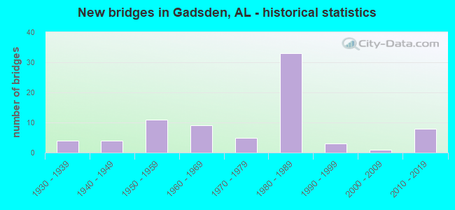
- New bridges - historical statistics
- 41930-1939
- 41940-1949
- 111950-1959
- 91960-1969
- 51970-1979
- 331980-1989
- 31990-1999
- 12000-2009
- 82010-2019
FCC Registered Antenna Towers: 333 (See the full list of FCC Registered Antenna Towers)
FCC Registered Commercial Land Mobile Towers: 4 (See the full list of FCC Registered Commercial Land Mobile Towers in Gadsden, AL)
FCC Registered Private Land Mobile Towers: 3 (See the full list of FCC Registered Private Land Mobile Towers)
FCC Registered Broadcast Land Mobile Towers: 62 (See the full list of FCC Registered Broadcast Land Mobile Towers)
FCC Registered Microwave Towers: 42 (See the full list of FCC Registered Microwave Towers in this town)
FCC Registered Paging Towers: 4 (See the full list of FCC Registered Paging Towers)
FCC Registered Maritime Coast & Aviation Ground Towers: 3 (See the full list of FCC Registered Maritime Coast & Aviation Ground Towers)
FCC Registered Amateur Radio Licenses: 259 (See the full list of FCC Registered Amateur Radio Licenses in Gadsden)
FAA Registered Aircraft Manufacturers and Dealers: 1 (See the full list of FAA Registered Manufacturers and Dealers in Gadsden)
FAA Registered Aircraft: 30 (See the full list of FAA Registered Aircraft)
| Home Mortgage Disclosure Act Aggregated Statistics For Year 2009 (Based on 6 full and 10 partial tracts) | ||||||||||||||
| A) FHA, FSA/RHS & VA Home Purchase Loans | B) Conventional Home Purchase Loans | C) Refinancings | D) Home Improvement Loans | E) Loans on Dwellings For 5+ Families | F) Non-occupant Loans on < 5 Family Dwellings (A B C & D) | G) Loans On Manufactured Home Dwelling (A B C & D) | ||||||||
|---|---|---|---|---|---|---|---|---|---|---|---|---|---|---|
| Number | Average Value | Number | Average Value | Number | Average Value | Number | Average Value | Number | Average Value | Number | Average Value | Number | Average Value | |
| LOANS ORIGINATED | 91 | $81,181 | 87 | $86,093 | 244 | $115,243 | 37 | $40,528 | 1 | $392,870 | 99 | $73,408 | 3 | $16,887 |
| APPLICATIONS APPROVED, NOT ACCEPTED | 3 | $100,237 | 3 | $45,840 | 25 | $81,864 | 7 | $45,521 | 0 | $0 | 2 | $21,635 | 1 | $29,840 |
| APPLICATIONS DENIED | 15 | $80,031 | 32 | $61,589 | 155 | $82,806 | 31 | $33,508 | 0 | $0 | 11 | $78,176 | 4 | $34,260 |
| APPLICATIONS WITHDRAWN | 3 | $107,113 | 9 | $88,467 | 69 | $92,597 | 4 | $28,510 | 0 | $0 | 6 | $74,448 | 0 | $0 |
| FILES CLOSED FOR INCOMPLETENESS | 4 | $58,918 | 0 | $0 | 21 | $91,495 | 2 | $36,045 | 0 | $0 | 0 | $0 | 0 | $0 |
Detailed mortgage data for all 16 tracts in Gadsden, AL
| Private Mortgage Insurance Companies Aggregated Statistics For Year 2009 (Based on 1 full and 7 partial tracts) | ||||||
| A) Conventional Home Purchase Loans | B) Refinancings | C) Non-occupant Loans on < 5 Family Dwellings (A & B) | ||||
|---|---|---|---|---|---|---|
| Number | Average Value | Number | Average Value | Number | Average Value | |
| LOANS ORIGINATED | 2 | $77,630 | 4 | $212,185 | 0 | $0 |
| APPLICATIONS APPROVED, NOT ACCEPTED | 4 | $54,102 | 5 | $193,734 | 1 | $22,470 |
| APPLICATIONS DENIED | 1 | $48,610 | 2 | $170,325 | 1 | $22,470 |
| APPLICATIONS WITHDRAWN | 0 | $0 | 0 | $0 | 0 | $0 |
| FILES CLOSED FOR INCOMPLETENESS | 1 | $67,390 | 0 | $0 | 0 | $0 |
2003 - 2018 National Fire Incident Reporting System (NFIRS) incidents
- Fire incident types reported to NFIRS in Gadsden, AL
- 1,37540.2%Outside Fires
- 1,21735.6%Structure Fires
- 54716.0%Mobile Property/Vehicle Fires
- 2828.2%Other
 Based on the data from the years 2003 - 2018 the average number of fire incidents per year is 214. The highest number of reported fires - 340 took place in 2006, and the least - 91 in 2003. The data has an increasing trend.
 When looking into fire subcategories, the most incidents belonged to: Outside Fires (40.2%), and Structure Fires (35.6%).
Fire-safe hotels and motels in Gadsden, Alabama:
- Broadway Inn, 2704 W Meighan Blvd, Gadsden, Alabama 35904 , Phone: (256) 543-3790
- Super 8, 2110 Rainbow Dr, Gadsden, Alabama 35901 , Phone: (256) 547-9033, Fax: (256) 547-3041
- Gadsden Inn & Suites, 200 Albert Rains Blvd, Gadsden, Alabama 35901 , Phone: (256) 543-7240, Fax: (256) 543-7240
- Motel 6, 1600 Rainbow Dr, Gadsden, Alabama 35901 , Phone: (256) 543-1105, Fax: (256) 543-7836
- Rodeway Inn, 3909 W Meighan Blvd, Gadsden, Alabama 35904 , Phone: (256) 543-0323, Fax: (256) 543-0376
- Econolodge, 1612 W Grand Ave, Gadsden, Alabama 35901 , Phone: (256) 442-7913, Fax: (256) 442-8234
- Holiday Inn Express & Suites, 106 Walker St, Gadsden, Alabama 35904 , Phone: (256) 691-0225, Fax: (256) 691-0230
- Comfort Suites Of Gadsden, 96 Walker St, Gadsden, Alabama 35904 , Phone: (256) 538-5770, Fax: (256) 538-5467
- 4 other hotels and motels
| Most common first names in Gadsden, AL among deceased individuals | ||
| Name | Count | Lived (average) |
|---|---|---|
| James | 865 | 71.1 years |
| Mary | 650 | 77.9 years |
| John | 644 | 73.3 years |
| William | 619 | 74.2 years |
| Robert | 382 | 71.1 years |
| Willie | 331 | 75.9 years |
| Charles | 326 | 69.9 years |
| George | 274 | 73.8 years |
| Annie | 249 | 79.8 years |
| Thomas | 247 | 71.9 years |
| Most common last names in Gadsden, AL among deceased individuals | ||
| Last name | Count | Lived (average) |
|---|---|---|
| Smith | 548 | 76.0 years |
| Johnson | 312 | 74.2 years |
| Williams | 264 | 73.7 years |
| Jones | 227 | 72.7 years |
| Brown | 204 | 75.8 years |
| Davis | 146 | 73.2 years |
| Wilson | 143 | 74.7 years |
| Miller | 138 | 74.2 years |
| Hill | 138 | 73.9 years |
| Martin | 134 | 73.8 years |
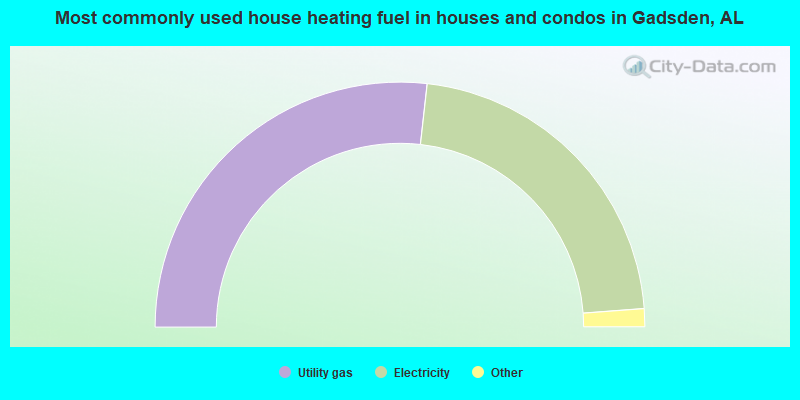
- 53.6%Utility gas
- 44.1%Electricity
- 1.4%Bottled, tank, or LP gas
- 0.5%Wood
- 0.5%No fuel used
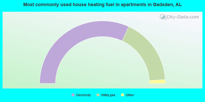
- 63.7%Electricity
- 34.4%Utility gas
- 1.8%Bottled, tank, or LP gas
- 0.1%No fuel used
Gadsden compared to Alabama state average:
- Median house value below state average.
- Length of stay since moving in significantly above state average.
- House age above state average.
- Institutionalized population percentage above state average.
Gadsden on our top lists:
- #39 on the list of "Top 101 cities with the most full-time firefighters per 1000 residents (population 5,000+)"
- #48 on the list of "Top 101 cities with the largest percentage of people in job corps and vocational training facilities (population 1,000+)"
- #52 on the list of "Top 101 cities with the most full-time park and recreation workers per 1000 residents (population 5,000+)"
- #62 on the list of "Top 101 cities with the most local government spending on current operations of parks and recreation per resident (population 10,000+)"
- #70 on the list of "Top 100 least-safe cities (highest city-data.com crime index) (pop. 5,000+)"
- #90 on the list of "Top 101 cities with the highest number of burglaries per 100,000 residents, excludes tourist destinations and others with a lot of outsiders visiting based on city industries data (population 5,000+)"
- #96 on the list of "Top 101 cities with the highest city-data.com crime index, excludes tourist destinations and others with a lot of outsiders visiting based on city industries data (population 5,000+)"
- #100 on the list of "Top 100 high-educated but low-earning cities (pop. 5,000+)"
- #13 on the list of "Top 101 counties with the highest number of deaths per 1000 residents 2007-2013 (pop. 50,000+)"
- #23 on the list of "Top 101 counties with the smallest number of children under 18 without health insurance coverage in 2000 (pop. 50,000+)"
- #53 on the list of "Top 101 counties with the smallest number of people without health insurance coverage in 2000 (pop. 50,000+)"

|
|
Total of 22 patent applications in 2008-2024.