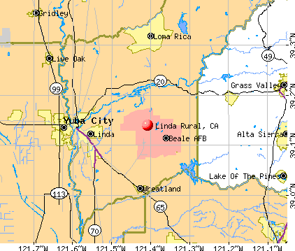
Linda Rural, California
Submit your own pictures of this place and show them to the world
- OSM Map
- General Map
- Google Map
- MSN Map
| Males: 4,926 | |
| Females: 4,403 |
| Median resident age: | 24.8 years |
| California median age: | 33.3 years |
Zip code: 95903
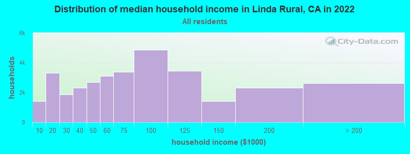
| Linda Rural: | $72,501 |
| CA: | $91,551 |
Estimated per capita income in 2022: $31,067 (it was $13,516 in 2000)
Linda Rural CCD income, earnings, and wages data
Estimated median house or condo value in 2022: $541,006 (it was $112,500 in 2000)
| Linda Rural: | $541,006 |
| CA: | $715,900 |
Detailed information about poverty and poor residents in Linda Rural, CA


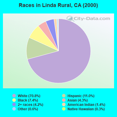
- 5,55570.8%White alone
- 86011.0%Hispanic
- 5807.4%Black alone
- 3374.3%Asian alone
- 3334.2%Two or more races
- 1131.4%American Indian alone
- 470.6%Other race alone
- 260.3%Native Hawaiian and Other
Pacific Islander alone
 Recent articles from our blog. Our writers, many of them Ph.D. graduates or candidates, create easy-to-read articles on a wide variety of topics.
Current Local Time: PST time zone
Land area: 136.9 square miles.
Population density: 68 people per square mile (very low).

| Linda Rural CCD: | 0.7% ($825) |
| California: | 0.8% ($1,564) |
Nearest city with pop. 50,000+: Loomis Basin-Folsom Lake, CA  (26.5 miles , pop. 67,397).
Nearest city with pop. 200,000+: Sacramento, CA (40.5 miles , pop. 407,018).
Nearest city with pop. 1,000,000+: Los Angeles, CA (387.9 miles , pop. 3,694,820).
Nearest cities:
), ), )Latitude: 39.14 N, Longitude: 121.41 W
Area code commonly used in this area: 530

| Here: | 7.1% |
| California: | 5.1% |
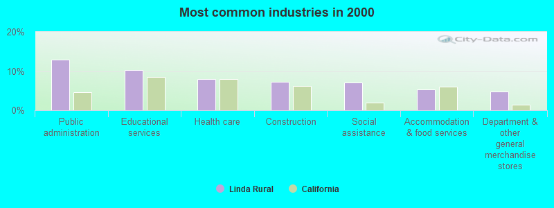
- Public administration (12.8%)
- Educational services (10.3%)
- Health care (7.9%)
- Construction (7.2%)
- Social assistance (7.1%)
- Accommodation & food services (5.3%)
- Department & other general merchandise stores (4.8%)
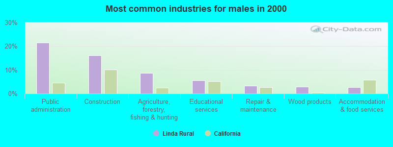
- Public administration (21.5%)
- Construction (16.2%)
- Agriculture, forestry, fishing & hunting (8.7%)
- Educational services (5.5%)
- Repair & maintenance (3.3%)
- Wood products (2.8%)
- Accommodation & food services (2.7%)
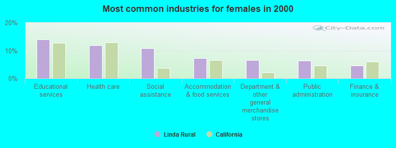
- Educational services (13.9%)
- Health care (11.8%)
- Social assistance (10.8%)
- Accommodation & food services (7.2%)
- Department & other general merchandise stores (6.6%)
- Public administration (6.4%)
- Finance & insurance (4.5%)
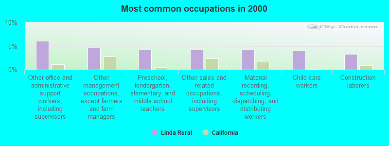
- Other office and administrative support workers, including supervisors (6.0%)
- Other management occupations, except farmers and farm managers (4.7%)
- Preschool, kindergarten, elementary, and middle school teachers (4.2%)
- Other sales and related occupations, including supervisors (4.2%)
- Material recording, scheduling, dispatching, and distributing workers (4.2%)
- Child care workers (4.0%)
- Construction laborers (3.3%)
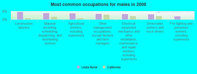
- Construction laborers (7.7%)
- Material recording, scheduling, dispatching, and distributing workers (6.5%)
- Agricultural workers, including supervisors (6.3%)
- Other management occupations, except farmers and farm managers (5.7%)
- Electrical equipment mechanics and other installation, maintenance, and repair workers, including supervisors (5.5%)
- Driver/sales workers and truck drivers (5.2%)
- Fire fighting and prevention workers, including supervisors (3.4%)
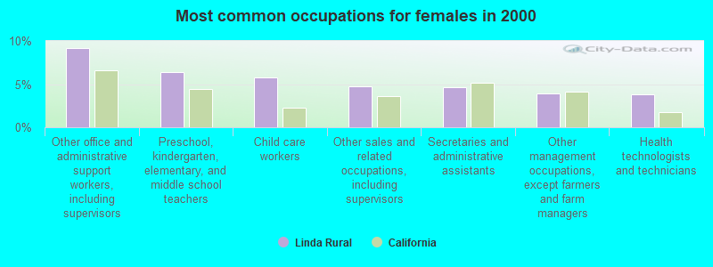
- Other office and administrative support workers, including supervisors (9.2%)
- Preschool, kindergarten, elementary, and middle school teachers (6.4%)
- Child care workers (5.8%)
- Other sales and related occupations, including supervisors (4.7%)
- Secretaries and administrative assistants (4.6%)
- Other management occupations, except farmers and farm managers (3.9%)
- Health technologists and technicians (3.8%)
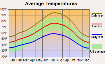
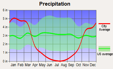
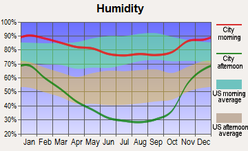
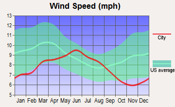
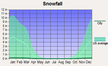
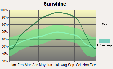
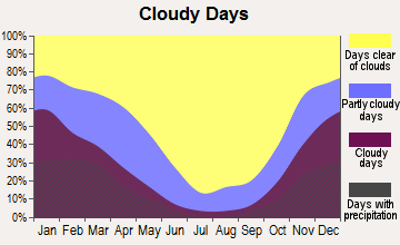
Average climate in Linda Rural, California
Based on data reported by over 4,000 weather stations
(lower is better)
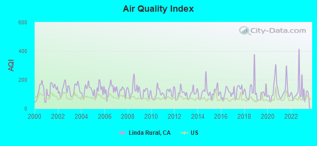
Air Quality Index (AQI) level in 2023 was 93.1. This is worse than average.
| City: | 93.1 |
| U.S.: | 72.6 |

Carbon Monoxide (CO) [ppm] level in 2018 was 0.191. This is better than average. Closest monitor was 11.3 miles away from the city center.
| City: | 0.191 |
| U.S.: | 0.251 |
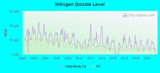
Nitrogen Dioxide (NO2) [ppb] level in 2022 was 6.65. This is worse than average. Closest monitor was 11.3 miles away from the city center.
| City: | 6.65 |
| U.S.: | 5.11 |
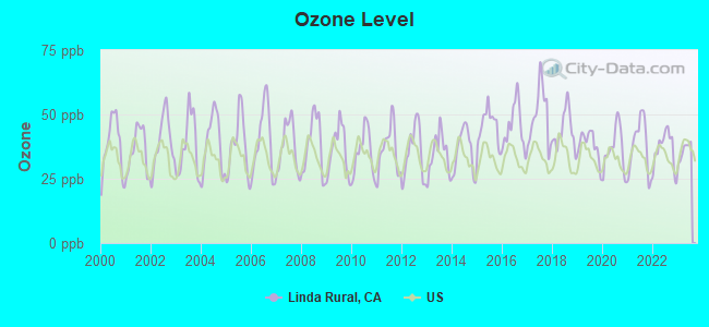
Ozone [ppb] level in 2023 was 35.8. This is about average. Closest monitor was 10.6 miles away from the city center.
| City: | 35.8 |
| U.S.: | 33.3 |
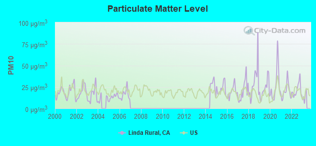
Particulate Matter (PM10) [µg/m3] level in 2022 was 21.5. This is about average. Closest monitor was 7.5 miles away from the city center.
| City: | 21.5 |
| U.S.: | 19.2 |
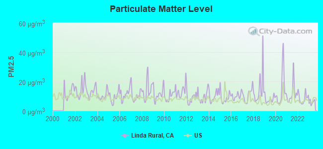
Particulate Matter (PM2.5) [µg/m3] level in 2023 was 5.93. This is better than average. Closest monitor was 11.3 miles away from the city center.
| City: | 5.93 |
| U.S.: | 8.11 |
Earthquake activity:
Linda Rural-area historical earthquake activity is significantly above California state average. It is 7256% greater than the overall U.S. average.On 4/18/1906 at 13:12:21, a magnitude 7.9 (7.9 UK, Class: Major, Intensity: VIII - XII) earthquake occurred 116.7 miles away from the city center, causing $524,000,000 total damage
On 10/3/1915 at 06:52:48, a magnitude 7.6 (7.6 UK) earthquake occurred 227.9 miles away from the city center
On 1/31/1922 at 13:17:28, a magnitude 7.6 (7.6 UK) earthquake occurred 244.9 miles away from Linda Rural center
On 4/25/1992 at 18:06:04, a magnitude 7.2 (6.3 MB, 7.1 MS, 7.2 MW, 7.1 MW, Depth: 9.4 mi) earthquake occurred 164.4 miles away from Linda Rural center, causing $75,000,000 total damage
On 10/18/1989 at 00:04:15, a magnitude 7.1 (6.5 MB, 7.1 MS, 6.9 MW, 7.0 ML) earthquake occurred 141.8 miles away from Linda Rural center, causing 62 deaths (62 shaking deaths) and 3757 injuries, causing $1,305,032,704 total damage
On 12/21/1932 at 06:10:09, a magnitude 7.2 (7.2 UK) earthquake occurred 184.3 miles away from the city center
Magnitude types: body-wave magnitude (MB), local magnitude (ML), surface-wave magnitude (MS), moment magnitude (MW)
Natural disasters:
The number of natural disasters in Yuba County (22) is greater than the US average (15).Major Disasters (Presidential) Declared: 12
Emergencies Declared: 3
Causes of natural disasters: Floods: 12, Fires: 6, Storms: 6, Winter Storms: 5, Landslides: 3, Mudslides: 3, Drought: 1, Freeze: 1, Heavy Rain: 1, Hurricane: 1, Tornado: 1, Other: 1 (Note: some incidents may be assigned to more than one category).
Hospitals and medical centers near Linda Rural:
- MARYSVILLE CARE CENTER (Nursing Home, about 10 miles away; MARYSVILLE, CA)
- RIDEOUT MEMORIAL HOSPITAL Acute Care Hospitals (about 11 miles away; MARYSVILLE, CA)
- MARYSVILLE DIALYSIS CENTER (Dialysis Facility, about 11 miles away; MARYSVILLE, CA)
- SUTTER SURGICAL HOSPITAL - NORTH VALLEY Acute Care Hospitals (about 12 miles away; YUBA CITY, CA)
- SUTTER NORTH HOME HEALTH (Home Health Center, about 12 miles away; YUBA CITY, CA)
- FREMONT MEDICAL CENTER (Hospital, about 12 miles away; YUBA CITY, CA)
- YUBA CITY CARE CENTER (Nursing Home, about 12 miles away; YUBA CITY, CA)
Colleges/universities with over 2000 students nearest to Linda Rural:
- Yuba College (about 8 miles; Marysville, CA; Full-time enrollment: 4,737)
- Sierra College (about 27 miles; Rocklin, CA; FT enrollment: 11,488)
- American River College (about 35 miles; Sacramento, CA; FT enrollment: 20,452)
- Universal Technical Institute of Northern California Inc (about 35 miles; Sacramento, CA; FT enrollment: 3,193)
- Folsom Lake College (about 37 miles; Folsom, CA; FT enrollment: 5,308)
- University of Phoenix-Sacramento Valley Campus (about 37 miles; Sacramento, CA; FT enrollment: 2,855)
- Butte College (about 38 miles; Oroville, CA; FT enrollment: 8,649)
Points of interest:
Notable locations in Linda Rural: Rose Bar (A), Empire Ranch (B), Peach Tree Golf and Country Club (C), Yuba Gold Field (D), Boardman Ranch (E), Bonanza Ranch (F), Beale Air Force Base Fire Department Station 2 (G), Smartville Fire Protection District (H), Beale Air Force Base Fire Department Station 1 (I). Display/hide their locations on the map
Cemetery: Smartville Cemetery (1). Display/hide its location on the map
Reservoirs: Beale Lake (A), Union Reservoir (B), Miller Lake (C), Lower Blackwelder Lake (D), Frisky Lake (E), Camp Far West Reservoir (F), Blackwelder Lake (G). Display/hide their locations on the map
Creeks: Brooks Creek (A), Cox Creek (B), Daugherty Creek (C), Deer Creek (D), Dempsey Creek (E), Wellman Creek (F), Vineyard Creek (G), Sanford Creek (H), Rock Creek (I). Display/hide their locations on the map
Park in Linda Rural: Lone Tree (1). Display/hide its location on the map
| This place: | 3.0 people |
| California: | 2.9 people |
| This place: | 22.1% |
| Whole state: | 69.4% |
| This place: | 2.9% |
| Whole state: | 5.9% |
Likely homosexual households (counted as self-reported same-sex unmarried-partner households)
- Lesbian couples: 0.3% of all households
- Gay men: 0.1% of all households
| This place: | 8.8% |
| Whole state: | 14.2% |
| This place: | 1.9% |
| Whole state: | 6.3% |
People in group quarters in Linda Rural in 2000:
- 334 people in military transient quarters for temporary residents
- 178 people in military barracks, etc.
- 26 people in other group homes
- 5 people in other noninstitutional group quarters
For population 15 years and over in Linda Rural:
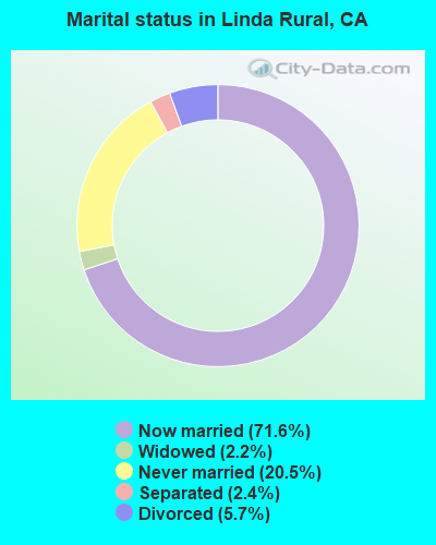
- Never married: 20.5%
- Now married: 71.6%
- Separated: 2.4%
- Widowed: 2.2%
- Divorced: 5.7%
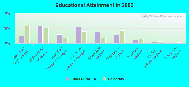
For population 25 years and over in Linda Rural:
- High school or higher: 90.2%
- Bachelor's degree or higher: 17.4%
- Graduate or professional degree: 6.5%
- Unemployed: 10.0%
- Mean travel time to work (commute): 18.5 minutes
| Here: | 8.9 |
| California average: | 16.1 |
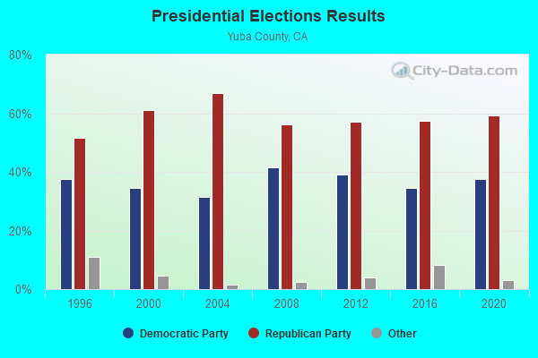
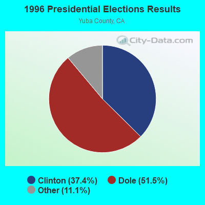
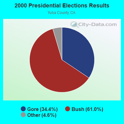
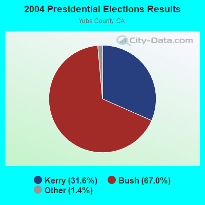
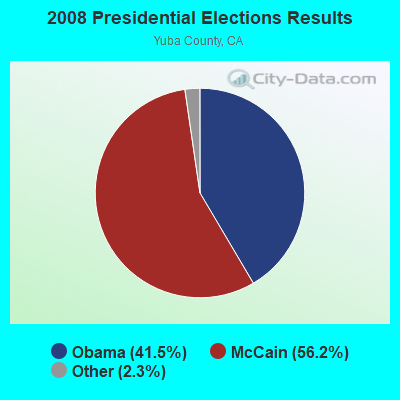
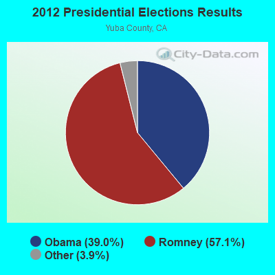
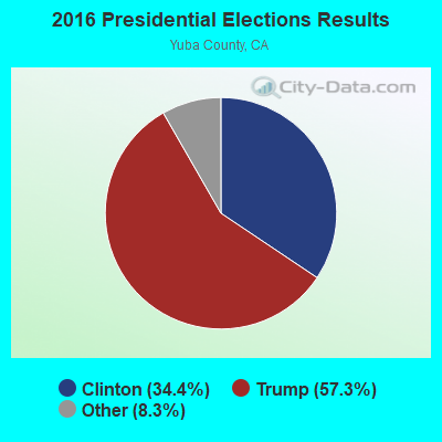
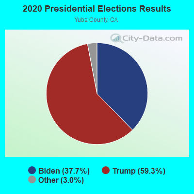
Graphs represent county-level data. Detailed 2008 Election Results
Religion statistics for Linda Rural, CA (based on Yuba County data)
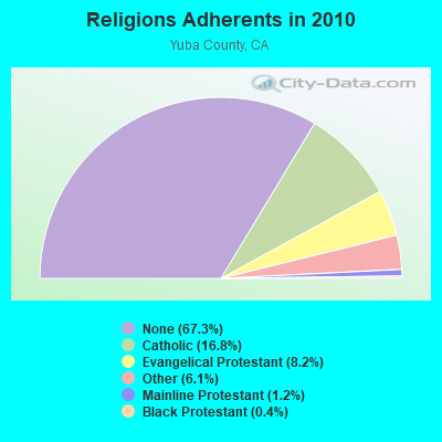
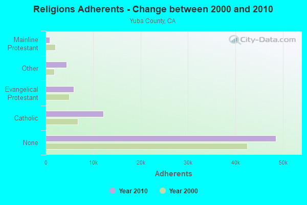
| Religion | Adherents | Congregations |
|---|---|---|
| Catholic | 12,138 | 3 |
| Evangelical Protestant | 5,904 | 46 |
| Other | 4,406 | 9 |
| Mainline Protestant | 891 | 7 |
| Black Protestant | 266 | 1 |
| None | 48,550 | - |
Food Environment Statistics:
| This county: | 1.81 / 10,000 pop. |
| California: | 2.14 / 10,000 pop. |
| Yuba County: | 0.14 / 10,000 pop. |
| State: | 0.04 / 10,000 pop. |
| Yuba County: | 0.84 / 10,000 pop. |
| California: | 0.62 / 10,000 pop. |
| Yuba County: | 2.09 / 10,000 pop. |
| California: | 1.49 / 10,000 pop. |
| Yuba County: | 4.04 / 10,000 pop. |
| California: | 7.42 / 10,000 pop. |
| Here: | 7.2% |
| California: | 7.3% |
| Yuba County: | 27.4% |
| California: | 21.3% |
| Yuba County: | 16.4% |
| State: | 17.9% |
12.15% of this county's 2021 resident taxpayers lived in other counties in 2020 ($52,892 average adjusted gross income)
| Here: | 12.15% |
| California average: | 5.19% |
0.27% of residents moved from foreign countries ($1,145 average AGI)
Yuba County: 0.27% California average: 0.03%
Top counties from which taxpayers relocated into this county between 2020 and 2021:
| from Sacramento County, CA | |
| from Sutter County, CA | |
| from Placer County, CA |
10.93% of this county's 2020 resident taxpayers moved to other counties in 2021 ($50,912 average adjusted gross income)
| Here: | 10.93% |
| California average: | 6.14% |
0.15% of residents moved to foreign countries ($622 average AGI)
Yuba County: 0.15% California average: 0.02%
Top counties to which taxpayers relocated from this county between 2020 and 2021:
| to Sutter County, CA | |
| to Sacramento County, CA | |
| to Placer County, CA |
Strongest AM radio stations in Linda Rural:
- KFBK (1530 AM; 50 kW; SACRAMENTO, CA; Owner: AMFM RADIO LICENSES, L.L.C.)
- KFIA (710 AM; 25 kW; CARMICHAEL, CA; Owner: VISTA BROADCASTING INC.)
- KMYC (1410 AM; 5 kW; MARYSVILLE, CA; Owner: THOMAS F. HUTH)
- KUBA (1600 AM; 5 kW; YUBA CITY, CA; Owner: HARLAN COMMUNICATIONS, INC.)
- KSTE (650 AM; 25 kW; RANCHO CORDOVA, CA; Owner: AMFM RADIO LICENSES, L.L.C.)
- KHTK (1140 AM; 50 kW; SACRAMENTO, CA; Owner: INFINITY RADIO SUBSIDIARY OPERATIONS INC.)
- KAHI (950 AM; 10 kW; AUBURN, CA; Owner: IHR EDUCATIONAL BROADCASTING)
- KNCO (830 AM; 5 kW; GRASS VALLEY, CA; Owner: NEVADA COUNTY BROADCASTERS, INC.)
- KLIB (1110 AM; 10 kW; ROSEVILLE, CA; Owner: WAY BROADCASTING, INC.)
- KCBS (740 AM; 50 kW; SAN FRANCISCO, CA; Owner: INFINITY BROADCASTING OPERATIONS, INC.)
- KKOH (780 AM; 50 kW; RENO, NV; Owner: CITADEL BROADCASTING COMPANY)
- KFSG (1690 AM; 10 kW; ROSEVILLE, CA; Owner: WAY BROADCASTING, INC.)
- KCBC (770 AM; 50 kW; RIVERBANK, CA; Owner: KIERTRON, INC.)
Strongest FM radio stations in Linda Rural:
- KXCL (103.9 FM; YUBA CITY, CA; Owner: HARLAN COMMUNICATIONS, INC.)
- KRCX-FM (99.9 FM; MARYSVILLE, CA; Owner: ENTRAVISION HOLDINGS, LLC)
- KMJE (101.5 FM; GRIDLEY, CA; Owner: RESULTS RADIO LICENSEE, LLC)
- K213BZ (90.5 FM; RICHVALE, CA; Owner: FAMILY STATIONS, INC.)
- KKCY (103.1 FM; COLUSA, CA; Owner: RESULTS RADIO LICENSEE, LLC)
- K258AQ (99.5 FM; YANKEE HILL, CA; Owner: CALVARY CHAPEL OF TWIN FALLS, INC.)
- KVMR (89.5 FM; NEVADA CITY, CA; Owner: NEVADA CITY COMMUNITY BROADCAST GRUP)
- KYIX (104.9 FM; SOUTH OROVILLE, CA; Owner: BUTTE BROADCASTING COMPANY, INC.)
- KLVS (99.3 FM; GRASS VALLEY, CA; Owner: EDUCATIONAL MEDIA FOUNDATION)
- KHHZ (97.7 FM; OROVILLE, CA; Owner: CLEAR CHANNEL BROADCASTING LICENSES, INC.)
- KNCO-FM (94.1 FM; GRASS VALLEY, CA; Owner: NEVADA COUNTY BROADCASTERS, INC.)
- KHAP (89.1 FM; CHICO, CA; Owner: FAMILY STATIONS, INC.)
- KHGQ (100.3 FM; QUINCY, CA; Owner: KEILY MILLER)
- KNDL (89.9 FM; ANGWIN, CA; Owner: HOWELL MOUNTAIN BROADCASTING COMPANY)
- KLVR (91.9 FM; SANTA ROSA, CA; Owner: EDUCATIONAL MEDIA FOUNDATION)
- KXTS (100.9 FM; CALISTOGA, CA; Owner: SINCLAIR TELECABLE, INC.)
- KBBF (89.1 FM; SANTA ROSA, CA; Owner: BILINGUAL B/CING. FOUNDATION, INC.)
- KUIC (95.3 FM; VACAVILLE, CA; Owner: KUIC, INC.)
- K284AG (104.7 FM; WOODLAND, CA; Owner: EDUCATIONAL MEDIA FOUNDATION)
- KHYL (101.1 FM; AUBURN, CA; Owner: AMFM RADIO LICENSES, L.L.C.)
TV broadcast stations around Linda Rural:
- KMMK-LP (Channel 14; SACRAMENTO, CA; Owner: CABALLERO TELEVISION TEXAS, L.L.C.)
- KEZT-CA (Channel 23; SACRAMENTO, CA; Owner: TELEFUTURA SACRAMENTO LLC)
- KSPX (Channel 29; SACRAMENTO, CA; Owner: PAXSON SACRAMENTO LICENSE, INC.)
- KTXL (Channel 40; SACRAMENTO, CA; Owner: CHANNEL 40, INC.)
- KQCA (Channel 58; STOCKTON, CA; Owner: KCRA HEARST-ARGYLE TELEVISION, INC.)
- KOVR (Channel 13; STOCKTON, CA; Owner: SCI - SACRAMENTO LICENSEE, LLC)
- KXTV (Channel 10; SACRAMENTO, CA; Owner: KXTV, INC.)
- KVIE (Channel 6; SACRAMENTO, CA; Owner: KVIE, INC.)
- K17EH (Channel 17; EUREKA, CA; Owner: MS COMMUNICATIONS, LLC)
- K27FX (Channel 27; EUREKA, CA; Owner: MS COMMUNICATIONS, LLC)
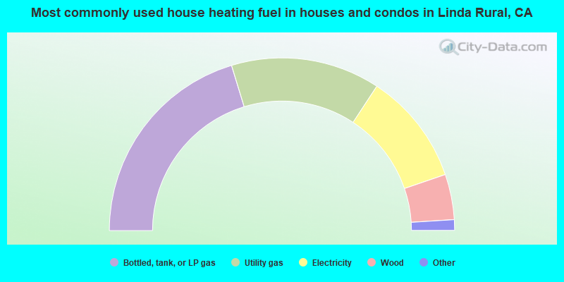
- 40.6%Bottled, tank, or LP gas
- 28.0%Utility gas
- 21.0%Electricity
- 8.5%Wood
- 1.2%Other fuel
- 0.8%Fuel oil, kerosene, etc.
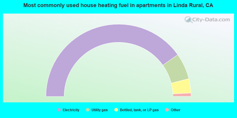
- 80.3%Electricity
- 11.7%Utility gas
- 6.4%Bottled, tank, or LP gas
- 1.1%Wood
- 0.4%No fuel used
Linda Rural compared to California state average:
- Hispanic race population percentage significantly below state average.
- Median age below state average.
- Foreign-born population percentage significantly below state average.
- Renting percentage significantly below state average.
- Length of stay since moving in significantly above state average.
- Number of rooms per house significantly below state average.
- House age significantly below state average.
Linda Rural on our top lists:
- #2 on the list of "Top 101 cities with largest percentage of females in industries: radio, tv, and computer stores (population 5,000+)"
- #3 on the list of "Top 101 cities with largest percentage of males in occupations: child care workers (population 5,000+)"
- #3 on the list of "Top 101 cities with largest percentage of males in industries: lumber and other construction materials merchant wholesalers (population 5,000+)"
- #7 on the list of "Top 101 cities with largest percentage of males in occupations: architects, surveyors, and cartographers (population 5,000+)"
- #7 on the list of "Top 101 cities with largest percentage of females in industries: social assistance (population 5,000+)"
- #8 on the list of "Top 101 cities with the largest percentage of people in military transient quarters for temporary residents (population 1,000+)"
- #9 on the list of "Top 101 cities with largest percentage of males in occupations: construction laborers (population 5,000+)"
- #11 on the list of "Top 101 cities with largest percentage of males in industries: furniture and home furnishings, and household appliance stores (population 5,000+)"
- #11 on the list of "Top 101 cities with the lowest percentage of family households, population 1,000+"
- #14 on the list of "Top 101 cities with largest percentage of females in occupations: child care workers (population 5,000+)"
- #16 on the list of "Top 101 cities with largest percentage of males in industries: retail florists (population 5,000+)"
- #18 on the list of "Top 101 cities with largest percentage of males in industries: social assistance (population 5,000+)"
- #19 on the list of "Top 101 cities with largest percentage of males in occupations: material recording, scheduling, dispatching, and distributing workers (population 5,000+)"
- #19 on the list of "Top 101 cities with largest percentage of males in industries: farm supplies merchant wholesalers (population 5,000+)"
- #24 on the list of "Top 101 cities with largest percentage of females in occupations: occupational and physical therapist assistants and aides (population 5,000+)"
- #24 on the list of "Top 101 cities with largest percentage of females in industries: department and other general merchandise stores (population 5,000+)"
- #34 on the list of "Top 101 cities with largest percentage of males in industries: pharmacies and drug stores (population 5,000+)"
- #36 on the list of "Top 101 cities with the most people taking a motorcycle to work (population 5,000+)"
- #58 on the list of "Top 101 cities with largest percentage of females in industries: food (population 5,000+)"
- #58 on the list of "Top 101 cities with largest percentage of females in industries: lumber and other construction materials merchant wholesalers (population 5,000+)"
- #3 (95903) on the list of "Top 101 zip codes with the smallest percentage of taxpayers using paid preparers for 2012 taxes (pop 5,000+)"
- #16 (95903) on the list of "Top 101 zip codes with the lowest charity contributions deductions as a percentage of AGI in 2012 (pop 5,000+)"
- #33 (95903) on the list of "Top 101 zip codes with the largest percentage of returns reporting salary or wage in 2012 (pop 5,000+)"
- #51 (95903) on the list of "Top 101 zip codes with the largest percentage of Scottish first ancestries (pop 5,000+)"
- #53 (95903) on the list of "Top 101 zip codes with the lowest 2012 average taxable interest for individuals (pop 5,000+)"
- #88 (95903) on the list of "Top 101 zip codes with the smallest percentage of taxpayers using charity contributions deductions in 2012 (pop 5,000+)"
- #30 on the list of "Top 101 counties with the highest percentage of residents relocating to other counties in 2011 (pop. 50,000+)"
- #33 on the list of "Top 101 counties with the highest percentage of residents relocating from foreign countries between 2010 and 2011 (pop. 50,000+)"
- #34 on the list of "Top 101 counties with the highest percentage of residents relocating to foreign countries in 2011 (pop. 50,000+)"
- #35 on the list of "Top 101 counties with highest percentage of residents voting for 3rd party candidates in the 2012 Presidential Election (pop. 50,000+)"
- #40 on the list of "Top 101 counties with the lowest surface withdrawal of fresh water for public supply (pop. 50,000+)"