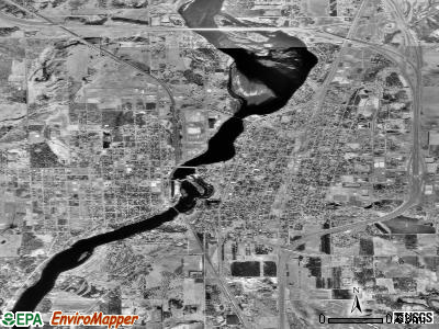
Little Falls, Minnesota
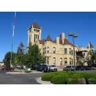
Little Falls: Historic Courthouse and Clock Tower
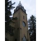
Little Falls: Gothic Revival Style Church in Little Falls
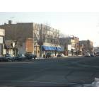
Little Falls: Downtown Little Falls during the winter of 2008

Little Falls: Little Falls Train Bridge
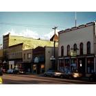
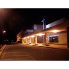
Little Falls: Eastern Edge of Downtown with the Clocktower in the back
Little Falls: Lindbergh Elementry
- add
your
Submit your own pictures of this city and show them to the world
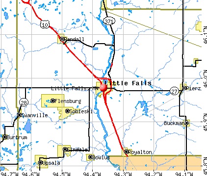
- OSM Map
- General Map
- Google Map
- MSN Map
Population change since 2000: +17.8%
 |
| Males: 4,143 | |
| Females: 4,951 |
| Median resident age: | 41.3 years |
| Minnesota median age: | 39.0 years |
Zip codes: 56345.
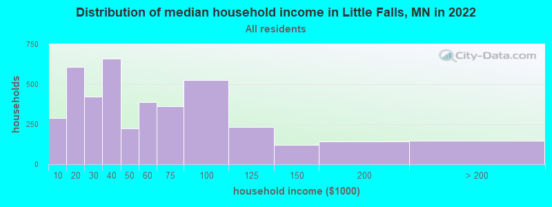
| Little Falls: | $43,414 |
| MN: | $82,338 |
Estimated per capita income in 2022: $29,296 (it was $15,924 in 2000)
Little Falls city income, earnings, and wages data
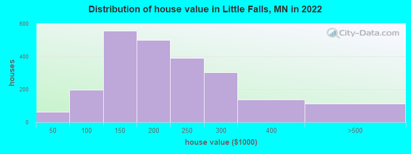
Estimated median house or condo value in 2022: $187,246 (it was $71,400 in 2000)
| Little Falls: | $187,246 |
| MN: | $314,600 |
Mean prices in 2022: all housing units: $201,550; detached houses: $204,749; townhouses or other attached units: $213,349; mobile homes: $38,489
Median gross rent in 2022: $789.
(17.0% for White Non-Hispanic residents, 19.2% for other race residents, 38.6% for two or more races residents)
Detailed information about poverty and poor residents in Little Falls, MN

Compare current foreclosures near Little Falls, MN:
| Photo | Address | Area | Beds / Baths | Price | Details |
|---|---|---|---|---|---|

|
#1
3rd St NE
Little Falls, MN 56345
|
1,032 sq. feet
|
1 baths 4 beds |
show details | |

|
#2
3rd St SW
Little Falls, MN 56345
|
2,500 sq. feet
|
3 baths 3 beds |
show details | |

|
#3
8th St SW
Little Falls, MN 56345
|
1,248 sq. feet
|
2 baths 2 beds |
show details | |

|
#4
140th Ave
Little Falls, MN 56345
|
2,284 sq. feet
|
2 baths 4 beds |
show details | |

|
#5
6th St NW
Little Falls, MN 56345
|
741 sq. feet
|
1 baths 3 beds |
show details | |

|
#6
2nd St NE
Little Falls, MN 56345
|
1,038 sq. feet
|
1 baths 4 beds |
show details | |

|
#7
6th Ave SW
Little Falls, MN 56345
|
4,340 sq. feet
|
3 baths 5 beds |
show details | |

|
#8
Hillton Rd
Little Falls, MN 56345
|
3,780 sq. feet
|
2 baths 5 beds |
show details | |

|
#9
Ginger Rd
Little Falls, MN 56345
|
1,656 sq. feet
|
3 baths 4 beds |
show details | |

|
#10
4th St SE
Little Falls, MN 56345
|
2,088 sq. feet
|
1 baths 3 beds |
show details |
| Photo | Address | Area | Beds / Baths | Price | Details |
|---|---|---|---|---|---|

|
#11
233rd St
Little Falls, MN 56345
|
1,752 sq. feet
|
2 baths 3 beds |
show details | |

|
#12
5th St SE
Little Falls, MN 56345
|
2,732 sq. feet
|
2 baths 3 beds |
show details | |

|
#13
N Highway 238
Little Falls, MN 56345
|
1,094 sq. feet
|
1 baths 3 beds |
show details | |

|
#14
10th Ave SW
Little Falls, MN 56345
|
3,036 sq. feet
|
2 baths 4 beds |
show details | |

|
#15
4th St NW
Little Falls, MN 56345
|
2,572 sq. feet
|
1 baths 3 beds |
show details | |

|
#16
165th St
Little Falls, MN 56345
|
3,518 sq. feet
|
3 baths 3 beds |
show details | |

|
#17
11th St SW
Little Falls, MN 56345
|
4,081 sq. feet
|
2 baths 5 beds |
show details | |

|
#18
90th St
Little Falls, MN 56345
|
4,864 sq. feet
|
3 baths 3 beds |
show details | |

|
#19
Edgewood Rd
Little Falls, MN 56345
|
2,356 sq. feet
|
2 baths 3 beds |
show details | |

|
#20
7th St SW
Little Falls, MN 56345
|
1,174 sq. feet
|
2 baths 4 beds |
show details |
| Photo | Address | Area | Beds / Baths | Price | Details |
|---|---|---|---|---|---|

|
#21
4th St SW
Little Falls, MN 56345
|
1,683 sq. feet
|
2 baths 3 beds |
show details | |

|
#22
4th St SW
Little Falls, MN 56345
|
- sq. feet
|
- baths - beds |
show details | |

|
#23
5th Ave Se, Apt 4
Little Falls, MN 56345
|
- sq. feet
|
- baths - beds |
show details | |

|
#24
Lindbergh Dr S
Little Falls, MN 56345
|
- sq. feet
|
- baths - beds |
show details | |

|
#25
Lindbergh Dr NW Trlr C4
Little Falls, MN 56345
|
- sq. feet
|
- baths - beds |
show details | |

|
#26
Anne Marie Cir Apt 203
Little Falls, MN 56345
|
- sq. feet
|
- baths - beds |
show details | |

|
#27
9th St NE
Little Falls, MN 56345
|
- sq. feet
|
- baths - beds |
show details | |

|
#28
8th St NW
Little Falls, MN 56345
|
- sq. feet
|
- baths - beds |
show details | |

|
#29
60th Ave
Swanville, MN 56382
|
1,436 sq. feet
|
1 baths 4 beds |
show details | |

|
#30
60th St
Bowlus, MN 56314
|
996 sq. feet
|
1 baths 3 beds |
show details |
| Photo | Address | Area | Beds / Baths | Price | Details |
|---|---|---|---|---|---|

|
#31
Dogwood Rd
Randall, MN 56475
|
4,038 sq. feet
|
1 baths 1 beds |
show details | |

|
#32
173rd St NW # 2
Royalton, MN 56373
|
1,852 sq. feet
|
3 baths 3 beds |
show details | |

|
#33
260th St
Cushing, MN 56443
|
2,295 sq. feet
|
1 baths 4 beds |
show details | |

|
#34
3rd Ave NW
Rice, MN 56367
|
864 sq. feet
|
1 baths 3 beds |
show details | |

|
#35
Woodchuck Trl
Randall, MN 56475
|
- sq. feet
|
- baths - beds |
show details | |

|
#36
W Walnut Ave, Unit 105
Upsala, MN 56384
|
- sq. feet
|
- baths - beds |
show details | |

|
#37
7th Ave NW
Rice, MN 56367
|
- sq. feet
|
- baths - beds |
show details | |

|
#38
County Road 2
Fort Ripley, MN 56449
|
- sq. feet
|
- baths - beds |
show details | |

|
Check over 1 million property listings on Foreclosure.com!
|
browse all offers | |||


- 8,43792.5%White alone
- 2893.2%Two or more races
- 1361.5%Hispanic
- 1161.3%Other race alone
- 470.5%Asian alone
- 190.2%Black alone
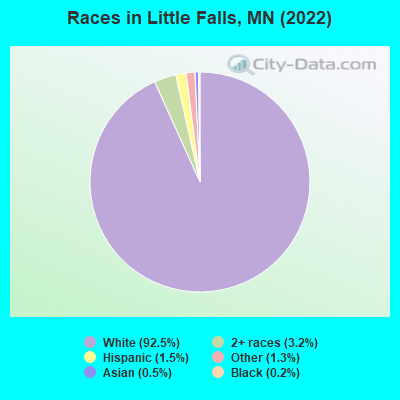
Races in Little Falls detailed stats: ancestries, foreign born residents, place of birth
According to our research of Minnesota and other state lists, there was 1 registered sex offender living in Little Falls, Minnesota as of April 27, 2024.
The ratio of all residents to sex offenders in Little Falls is 8,792 to 1.
The ratio of registered sex offenders to all residents in this city is near the state average.
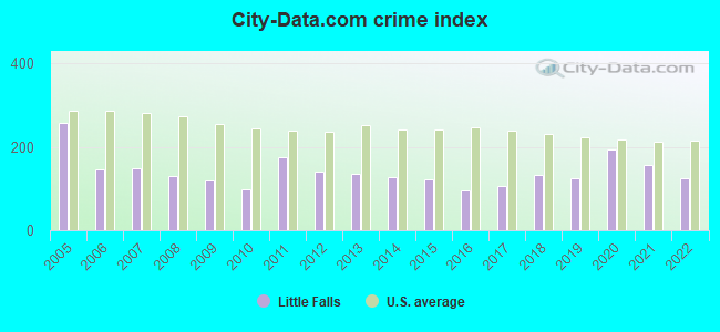
Type |
2009 |
2010 |
2011 |
2012 |
2013 |
2014 |
2015 |
2016 |
2017 |
2018 |
2019 |
2020 |
2021 |
2022 |
|---|---|---|---|---|---|---|---|---|---|---|---|---|---|---|
| Murders (per 100,000) | 0 (0.0) | 0 (0.0) | 1 (11.9) | 0 (0.0) | 0 (0.0) | 0 (0.0) | 0 (0.0) | 0 (0.0) | 0 (0.0) | 0 (0.0) | 0 (0.0) | 0 (0.0) | 1 (11.6) | 0 (0.0) |
| Rapes (per 100,000) | 2 (24.7) | 2 (24.0) | 4 (47.6) | 2 (23.8) | 1 (12.1) | 3 (36.6) | 1 (12.3) | 1 (11.6) | 3 (34.6) | 2 (23.0) | 0 (0.0) | 5 (57.6) | 1 (11.6) | 2 (22.2) |
| Robberies (per 100,000) | 0 (0.0) | 0 (0.0) | 0 (0.0) | 0 (0.0) | 0 (0.0) | 0 (0.0) | 0 (0.0) | 1 (11.6) | 0 (0.0) | 1 (11.5) | 0 (0.0) | 0 (0.0) | 0 (0.0) | 0 (0.0) |
| Assaults (per 100,000) | 2 (24.7) | 3 (36.0) | 9 (107.1) | 13 (154.7) | 9 (108.9) | 8 (97.6) | 10 (122.6) | 2 (23.2) | 5 (57.7) | 9 (103.7) | 8 (92.3) | 14 (161.3) | 13 (151.2) | 4 (44.3) |
| Burglaries (per 100,000) | 2 (24.7) | 8 (95.9) | 16 (190.3) | 10 (119.0) | 19 (229.9) | 6 (73.2) | 9 (110.3) | 15 (174.2) | 15 (173.1) | 20 (230.3) | 23 (265.3) | 16 (184.3) | 20 (232.6) | 22 (243.8) |
| Thefts (per 100,000) | 171 (2,110) | 127 (1,522) | 153 (1,820) | 156 (1,856) | 170 (2,057) | 132 (1,610) | 143 (1,753) | 122 (1,417) | 98 (1,131) | 139 (1,601) | 175 (2,019) | 178 (2,050) | 134 (1,559) | 167 (1,850) |
| Auto thefts (per 100,000) | 8 (98.7) | 5 (59.9) | 7 (83.3) | 9 (107.1) | 6 (72.6) | 10 (122.0) | 9 (110.3) | 9 (104.5) | 11 (126.9) | 12 (138.2) | 9 (103.8) | 24 (276.4) | 16 (186.1) | 9 (99.7) |
| Arson (per 100,000) | 0 (0.0) | 0 (0.0) | 0 (0.0) | 0 (0.0) | 0 (0.0) | 0 (0.0) | 1 (12.3) | 1 (11.6) | 0 (0.0) | 0 (0.0) | 1 (11.5) | 0 (0.0) | 0 (0.0) | 0 (0.0) |
| City-Data.com crime index | 118.7 | 98.8 | 176.0 | 141.1 | 135.6 | 128.1 | 121.0 | 94.6 | 106.8 | 133.8 | 126.1 | 195.3 | 156.3 | 125.7 |
The City-Data.com crime index weighs serious crimes and violent crimes more heavily. Higher means more crime, U.S. average is 246.1. It adjusts for the number of visitors and daily workers commuting into cities.
Crime rate in Little Falls detailed stats: murders, rapes, robberies, assaults, burglaries, thefts, arson
Full-time law enforcement employees in 2021, including police officers: 16 (14 officers - 13 male; 1 female).
| Officers per 1,000 residents here: | 1.63 |
| Minnesota average: | 1.76 |
 Recent articles from our blog. Our writers, many of them Ph.D. graduates or candidates, create easy-to-read articles on a wide variety of topics.

 | Why did you move away from the Twin Cities? (82 replies) |
| Crime in Mn (117 replies) |
| The Minnesota Weather Thread (1860 replies) |
| Islamic Center Bombed in Bloomington (34 replies) |
| Rochester vs Minneapolis (15 replies) |
| Where did all the Embers go? (26 replies) |
Latest news from Little Falls, MN collected exclusively by city-data.com from local newspapers, TV, and radio stations
Ancestries: German (36.2%), Norwegian (13.2%), Polish (11.4%), American (7.9%), Swedish (4.2%), English (3.7%).
Current Local Time: CST time zone
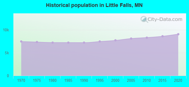
Incorporated in 1879
Land area: 6.26 square miles.
Population density: 1,452 people per square mile (low).
81 residents are foreign born
| This city: | 0.9% |
| Minnesota: | 8.5% |
Median real estate property taxes paid for housing units with mortgages in 2022: $1,870 (1.0%)
Median real estate property taxes paid for housing units with no mortgage in 2022: $2,410 (1.2%)
Nearest city with pop. 50,000+: St. Cloud, MN  (30.5 miles , pop. 59,107).
Nearest city with pop. 200,000+: Minneapolis, MN (88.0 miles , pop. 382,618).
Nearest city with pop. 1,000,000+: Chicago, IL (438.9 miles , pop. 2,896,016).
Nearest cities:
), Latitude: 45.98 N, Longitude: 94.36 W
Daytime population change due to commuting: +2,248 (+24.7%)
Workers who live and work in this city: 2,317 (61.9%)
Area code: 320
Little Falls, Minnesota accommodation & food services, waste management - Economy and Business Data
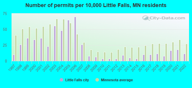
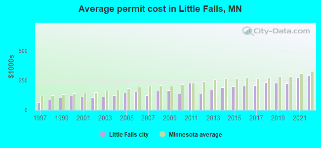
Single-family new house construction building permits:
- 2022: 9 buildings, average cost: $293,000
- 2021: 14 buildings, average cost: $277,800
- 2020: 13 buildings, average cost: $226,400
- 2019: 6 buildings, average cost: $231,600
- 2018: 9 buildings, average cost: $234,300
- 2017: 8 buildings, average cost: $210,500
- 2016: 8 buildings, average cost: $202,500
- 2015: 3 buildings, average cost: $201,700
- 2014: 4 buildings, average cost: $194,100
- 2013: 7 buildings, average cost: $172,500
- 2012: 3 buildings, average cost: $137,000
- 2011: 3 buildings, average cost: $231,800
- 2010: 3 buildings, average cost: $137,000
- 2009: 5 buildings, average cost: $168,200
- 2008: 6 buildings, average cost: $163,800
- 2007: 20 buildings, average cost: $126,500
- 2006: 54 buildings, average cost: $153,400
- 2005: 50 buildings, average cost: $147,200
- 2004: 37 buildings, average cost: $126,100
- 2003: 43 buildings, average cost: $113,000
- 2002: 18 buildings, average cost: $109,600
- 2001: 28 buildings, average cost: $112,700
- 2000: 26 buildings, average cost: $120,000
- 1999: 28 buildings, average cost: $105,300
- 1998: 20 buildings, average cost: $86,300
- 1997: 8 buildings, average cost: $66,300
| Here: | 5.2% |
| Minnesota: | 2.6% |
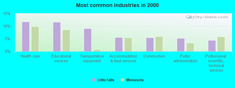
- Health care (11.8%)
- Educational services (11.6%)
- Transportation equipment (9.0%)
- Accommodation & food services (5.5%)
- Construction (5.4%)
- Public administration (5.2%)
- Professional, scientific, technical services (4.4%)
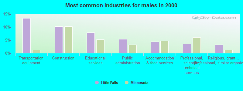
- Transportation equipment (13.3%)
- Construction (10.3%)
- Educational services (7.9%)
- Public administration (5.4%)
- Accommodation & food services (4.4%)
- Professional, scientific, technical services (3.5%)
- Religious, grantmaking, civic, professional, similar organizations (3.3%)
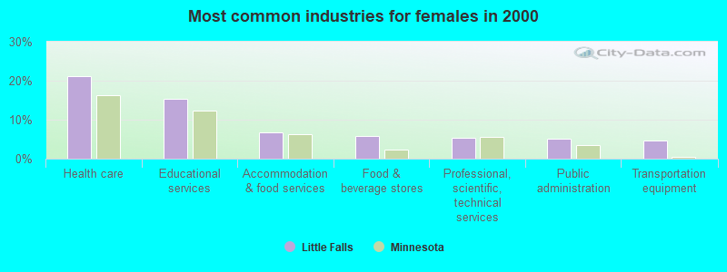
- Health care (21.2%)
- Educational services (15.4%)
- Accommodation & food services (6.6%)
- Food & beverage stores (5.8%)
- Professional, scientific, technical services (5.3%)
- Public administration (5.0%)
- Transportation equipment (4.6%)
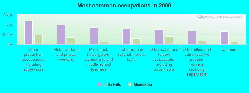
- Other production occupations, including supervisors (5.8%)
- Metal workers and plastic workers (4.8%)
- Preschool, kindergarten, elementary, and middle school teachers (4.3%)
- Laborers and material movers, hand (3.8%)
- Other sales and related occupations, including supervisors (3.7%)
- Other office and administrative support workers, including supervisors (3.4%)
- Cashiers (3.3%)
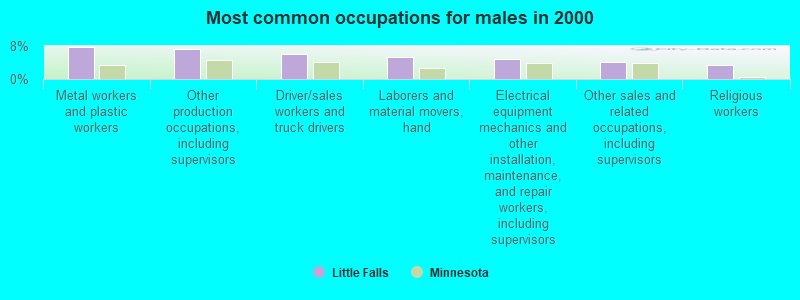
- Metal workers and plastic workers (7.7%)
- Other production occupations, including supervisors (7.3%)
- Driver/sales workers and truck drivers (5.9%)
- Laborers and material movers, hand (5.3%)
- Electrical equipment mechanics and other installation, maintenance, and repair workers, including supervisors (4.9%)
- Other sales and related occupations, including supervisors (4.2%)
- Religious workers (3.3%)
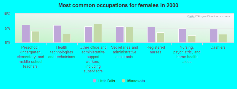
- Preschool, kindergarten, elementary, and middle school teachers (6.2%)
- Health technologists and technicians (6.0%)
- Other office and administrative support workers, including supervisors (5.6%)
- Secretaries and administrative assistants (5.6%)
- Registered nurses (5.4%)
- Nursing, psychiatric, and home health aides (4.9%)
- Cashiers (4.7%)
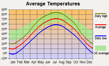
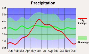
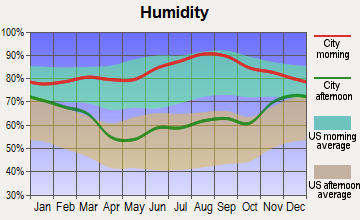
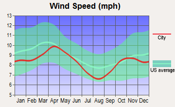
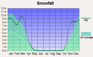
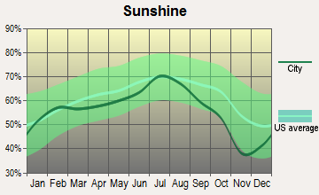
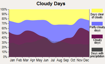
Average climate in Little Falls, Minnesota
Based on data reported by over 4,000 weather stations
|
|


Tornado activity:
Little Falls-area historical tornado activity is slightly below Minnesota state average. It is 15% smaller than the overall U.S. average.
On 9/18/1997, a category F3 (max. wind speeds 158-206 mph) tornado 16.4 miles away from the Little Falls city center killed one person and injured one person and caused $2 million in damages.
On 6/11/1966, a category F4 (max. wind speeds 207-260 mph) tornado 45.1 miles away from the city center caused between $50,000 and $500,000 in damages.
Earthquake activity:
Little Falls-area historical earthquake activity is significantly above Minnesota state average. It is 45% smaller than the overall U.S. average.On 7/9/1975 at 14:54:15, a magnitude 4.6 (4.6 MB, Class: Light, Intensity: IV - V) earthquake occurred 83.6 miles away from the city center
On 6/5/1993 at 01:24:53, a magnitude 4.1 (4.1 LG, Depth: 6.2 mi) earthquake occurred 95.3 miles away from Little Falls center
On 3/4/1983 at 06:32:18, a magnitude 4.6 (4.4 MB, 4.6 LG, 4.4 ML) earthquake occurred 274.8 miles away from the city center
On 10/20/1995 at 15:57:18, a magnitude 3.7 (3.7 LG, Depth: 3.1 mi, Class: Light, Intensity: II - III) earthquake occurred 121.1 miles away from the city center
On 2/9/1994 at 08:45:35, a magnitude 3.1 (3.1 LG, Depth: 3.1 mi) earthquake occurred 74.3 miles away from Little Falls center
On 2/7/2020 at 18:30:28, a magnitude 3.3 (3.3 ML) earthquake occurred 129.7 miles away from the city center
Magnitude types: regional Lg-wave magnitude (LG), body-wave magnitude (MB), local magnitude (ML)
Natural disasters:
The number of natural disasters in Morrison County (11) is smaller than the US average (15).Major Disasters (Presidential) Declared: 7
Emergencies Declared: 2
Causes of natural disasters: Floods: 7, Storms: 3, Drought: 1, Fire: 1, Hurricane: 1, Wind: 1, Other: 1 (Note: some incidents may be assigned to more than one category).

Hospitals and medical centers in Little Falls:
- ST CAMILLUS PLACE (1100 SE 4TH STREET)
- ST GABRIELS HOSPITAL (Voluntary non-profit - Private, 815 SOUTHEAST SECOND STREET)
- UNITY FAMILY HOSPICE (815 SOUTHEAST SECOND STREET)
- LUTHERAN CARE CENTER (1200 FIRST AVENUE NORTHEAST)
- LUTHERAN SENIOR CITIZENS HOME (1200 1ST AVE NE)
- ST OTTOS CARE CENTER (920 SOUTHEAST 4TH STREET)
- ST OTTOS HOME (920 SOUTHEAST FOURTH STREET)
- CENTRACARE KIDNEY PROG AT ST GABRIELS HOSP (808 3RD ST SE, #330)
- UNITY FAMILY HOME CARE HOSPICE (815 SOUTHEAST SECOND STREET)
Airports located in Little Falls:
- Little Falls/Morrison County-Lindbergh Fld Airport (LXL) (Runways: 2, Air Taxi Ops: 400, Itinerant Ops: 4,000, Local Ops: 18,000, Military Ops: 50)
Colleges/universities with over 2000 students nearest to Little Falls:
- Central Lakes College-Brainerd (about 27 miles; Brainerd, MN; Full-time enrollment: 3,371)
- St Cloud Technical and Community College (about 29 miles; Saint Cloud, MN; FT enrollment: 3,493)
- College of Saint Benedict (about 30 miles; Saint Joseph, MN; FT enrollment: 2,025)
- Rasmussen College-Minnesota (about 31 miles; St. Cloud, MN; FT enrollment: 4,575)
- Saint Cloud State University (about 32 miles; Saint Cloud, MN; FT enrollment: 12,822)
- Alexandria Technical & Community College (about 50 miles; Alexandria, MN; FT enrollment: 2,324)
- Ridgewater College (about 68 miles; Willmar, MN; FT enrollment: 3,288)
Public high schools in Little Falls:
- MID STATE ED DIST STEPS TRANS. PROG (Location: 1906 1ST AVENUE, Grades: 12)
- MSED PAES LAB (Location: 1936 1ST AVENUE NORTHEAST, Grades: 9-12)
- LITTLE FALLS SENIOR HIGH (Location: 1001 SE 5TH AVE, Grades: 9-12)
- LITTLE FALLS CONTINUING EDUCATION (Location: 116 8TH AVE SE, Grades: 9-12)
Public elementary/middle schools in Little Falls:
- MORRISON COUNTY LEARNING CENTER (Location: 606 NE 7TH STREET, Grades: KG-8)
- LINCOLN ELEMENTARY (Location: 300 SW 6TH ST, Grades: PK-5)
- LINDBERGH ELEMENTARY (Location: 101 SE 9TH ST, Grades: PK-5)
- COMMUNITY MIDDLE (Location: 1000 1ST AVE NE, Grades: 6-8)
Private elementary/middle school in Little Falls:
- MARY OF LOURDES SCHOOL (Students: 313, Location: 307 4TH ST SE, Grades: PK-8)
User-submitted facts and corrections:
- Hydroelectric dam in mid-town, 24ft headwater, build and rebuilt during late 1800's, present height reached by 4.5 foot increase in early 1920's, headwater extends north 3.5 miles to Belle Prairie Rapids (upstream limit of power boating). The dam's tailwater is the upper end of the 10 mile long Blanchard Dam resevior.
Points of interest:
Notable locations in Little Falls: Pine Grove Zoo (A), Little Falls Country Club (B), Little Falls (C), Little Falls Fire Department Station 2 (D), Charles A Lindbergh House (E), Charles A Weyerhaeuser Museum (F), Morrison County Courthouse (G), Minnesota Fishing Museum (H), Little Falls Fire Department Station 1 (I), Little Falls Police Department (J), Little Falls City Hall (K), Carnegie Library (L). Display/hide their locations on the map
Churches in Little Falls include: First Baptist Church (A), Holy Family Parish (B), Grace Covenant Church (C), Saint Mary's Church (D), First United Church (E), Little Falls Alliance Church (F), Zion Lutheran Church (G), Our Saviour Episcopal Church (H), Bethel Lutheran Church (I). Display/hide their locations on the map
Cemeteries: Oakland Cemetery (1), Calvary Cemetery (2), Franciscan Sisters Convent Cemetery (3). Display/hide their locations on the map
Creek: Pike Creek (A). Display/hide its location on the map
Parks in Little Falls include: Lyons Park (1), Riverside Park (2), Pine Grove Park (3), Memorial Park (4), James Green Park (5), Kiwanis Park (6), Maple Island Park (7), South End Park (8), Lindbergh House Historical Marker (9). Display/hide their locations on the map
Tourist attractions: Charles A Lindbergh House State Historic Site (Museums; 1200 Lindbergh Drive South), Morrison County Historical Society (Cultural Attractions- Events- & Facilities; 2151 Lindbergh Drive South), Minnesota Amusements (Amusement & Theme Parks; 15041 Highway 115), Nouis Amusement Park (Amusement & Theme Parks; 17261 Haven Road), Little Falls Convention & Visitors Bureau (Tours & Charters; 606 1st Street Northeast).
Hotels: Little Falls Super 8 Motel (300 12th St NE), Clifwood Motel (1201 Haven Road), Americinn - Little Falls- Mn (306 Lemieur St), Anderson's Pine Edge Inn (308 First Street Southeast), Super 8 Little Falls MN (300 12th Street Northeast).
Birthplace of: Duane Bobick - Boxer, Dave Thompson (radio host) - Politician, Becky Lourey - Politician, Anne Simonett - Judge, Herb Joesting - Football player and coach, Jim Langer - Football player, Mike LeMieur - Politician, Mike Poepping - Major League Baseball outfielder.
| This city: | 2.2 people |
| Minnesota: | 2.5 people |
| This city: | 57.0% |
| Whole state: | 64.6% |
| This city: | 9.4% |
| Whole state: | 6.9% |
Likely homosexual households (counted as self-reported same-sex unmarried-partner households)
- Lesbian couples: 0.2% of all households
- Gay men: 0.1% of all households
People in group quarters in Little Falls in 2010:
- 143 people in nursing facilities/skilled-nursing facilities
- 104 people in group homes intended for adults
- 61 people in other noninstitutional facilities
- 58 people in local jails and other municipal confinement facilities
People in group quarters in Little Falls in 2000:
- 216 people in homes for the mentally retarded
- 85 people in nursing homes
- 77 people in religious group quarters
- 35 people in local jails and other confinement facilities (including police lockups)
Banks with branches in Little Falls (2011 data):
- U.S. Bank National Association: Little Falls Main Branch, Little Falls Drive Up Branch, Little Falls Eastgate Branch. Info updated 2012/01/30: Bank assets: $330,470.8 mil, Deposits: $236,091.5 mil, headquarters in Cincinnati, OH, positive income, 3121 total offices, Holding Company: U.S. Bancorp
- Bank of the West: Little Falls Branch at 65 East Broadway, branch established on 1883/01/01. Info updated 2009/11/16: Bank assets: $62,408.3 mil, Deposits: $43,995.2 mil, headquarters in San Francisco, CA, positive income, 647 total offices, Holding Company: Bnp Paribas
- Pine Country Bank: at 1201 1st Avenue Ne, branch established on 1927/05/11. Info updated 2006/11/03: Bank assets: $150.9 mil, Deposits: $138.7 mil, local headquarters, positive income, Agricultural Specialization, 4 total offices, Holding Company: Tysan Corporation, The
For population 15 years and over in Little Falls:
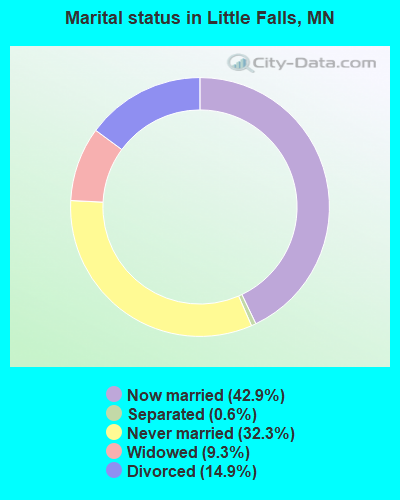
- Never married: 32.3%
- Now married: 42.9%
- Separated: 0.6%
- Widowed: 9.3%
- Divorced: 14.9%
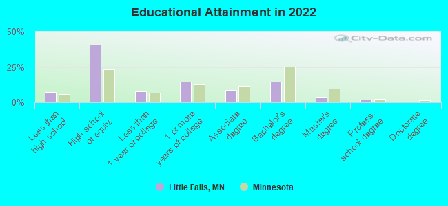
For population 25 years and over in Little Falls:
- High school or higher: 91.7%
- Bachelor's degree or higher: 20.0%
- Graduate or professional degree: 5.9%
- Unemployed: 7.2%
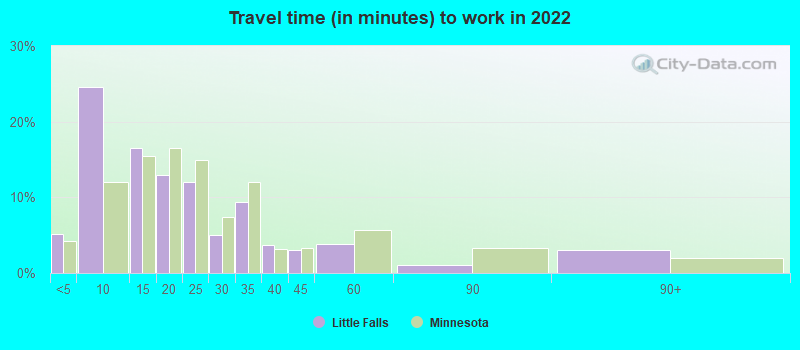
- Mean travel time to work (commute): 18.5 minutes
| Here: | 9.6 |
| Minnesota average: | 10.9 |

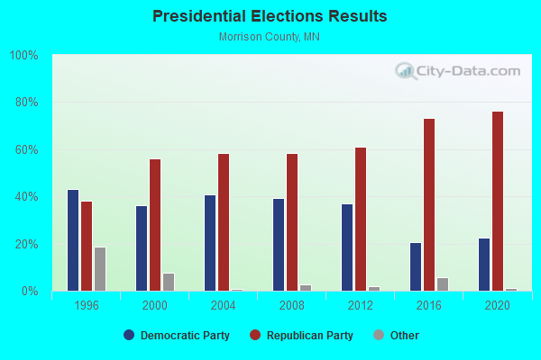


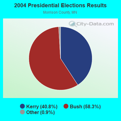
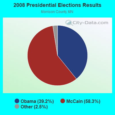
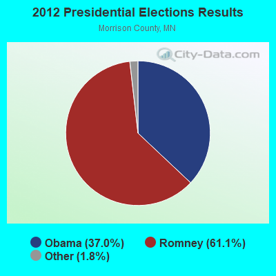
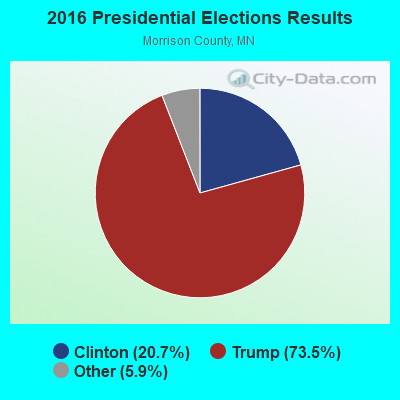
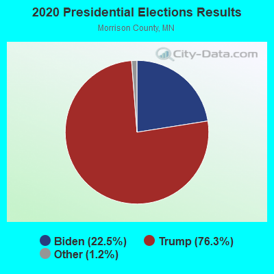
Graphs represent county-level data. Detailed 2008 Election Results
Religion statistics for Little Falls, MN (based on Morrison County data)
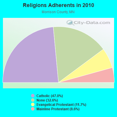
| Religion | Adherents | Congregations |
|---|---|---|
| Catholic | 15,614 | 19 |
| Evangelical Protestant | 3,874 | 23 |
| Mainline Protestant | 2,871 | 10 |
| Other | 1 | 1 |
| None | 10,838 | - |
Food Environment Statistics:
| Morrison County: | 3.06 / 10,000 pop. |
| State: | 1.83 / 10,000 pop. |
| Morrison County: | 4.90 / 10,000 pop. |
| Minnesota: | 3.90 / 10,000 pop. |
| Here: | 8.88 / 10,000 pop. |
| State: | 6.98 / 10,000 pop. |
| This county: | 6.9% |
| Minnesota: | 6.5% |
| Morrison County: | 28.4% |
| Minnesota: | 25.9% |
| Morrison County: | 9.0% |
| State: | 13.0% |
Health and Nutrition:
| Little Falls: | 47.6% |
| Minnesota: | 50.6% |
| This city: | 42.2% |
| Minnesota: | 48.4% |
| Little Falls: | 28.8 |
| Minnesota: | 28.5 |
| This city: | 23.5% |
| Minnesota: | 21.0% |
| Little Falls: | 13.3% |
| State: | 9.8% |
| Here: | 6.8 |
| Minnesota: | 6.8 |
| Little Falls: | 34.6% |
| State: | 33.5% |
| Little Falls: | 52.0% |
| Minnesota: | 57.7% |
| Little Falls: | 74.8% |
| Minnesota: | 79.3% |
More about Health and Nutrition of Little Falls, MN Residents
| Local government employment and payroll (March 2022) | |||||
| Function | Full-time employees | Monthly full-time payroll | Average yearly full-time wage | Part-time employees | Monthly part-time payroll |
|---|---|---|---|---|---|
| Police Protection - Officers | 14 | $102,196 | $87,597 | 2 | $2,438 |
| Streets and Highways | 12 | $91,678 | $91,678 | 0 | $0 |
| Sewerage | 4 | $21,908 | $65,724 | 0 | $0 |
| Financial Administration | 4 | $26,534 | $79,602 | 0 | $0 |
| Other Government Administration | 3 | $24,308 | $97,232 | 8 | $14,614 |
| Water Supply | 3 | $18,578 | $74,312 | 0 | $0 |
| Parks and Recreation | 3 | $12,272 | $49,088 | 3 | $5,212 |
| Police - Other | 2 | $9,225 | $55,350 | 0 | $0 |
| Other and Unallocable | 1 | $4,243 | $50,916 | 3 | $2,402 |
| Firefighters | 1 | $8,080 | $96,960 | 31 | $9,300 |
| Totals for Government | 47 | $319,021 | $81,452 | 47 | $33,967 |
Little Falls government finances - Expenditure in 2021 (per resident):
- Construction - Sewerage: $12,953,000 ($1424.35)
Regular Highways: $2,065,000 ($227.07)
Water Utilities: $1,137,000 ($125.03)
Air Transportation: $689,000 ($75.76)
Parks and Recreation: $90,000 ($9.90)
- Current Operations - Police Protection: $1,942,000 ($213.55)
General - Other: $1,707,000 ($187.71)
Sewerage: $1,349,000 ($148.34)
Water Utilities: $1,167,000 ($128.33)
Regular Highways: $1,110,000 ($122.06)
Parks and Recreation: $1,016,000 ($111.72)
Central Staff Services: $840,000 ($92.37)
Solid Waste Management: $808,000 ($88.85)
Local Fire Protection: $423,000 ($46.51)
Air Transportation: $165,000 ($18.14)
Protective Inspection and Regulation - Other: $95,000 ($10.45)
Judicial and Legal Services: $87,000 ($9.57)
Libraries: $66,000 ($7.26)
Hospitals: $51,000 ($5.61)
Housing and Community Development: $47,000 ($5.17)
General Public Buildings: $44,000 ($4.84)
Financial Administration: $28,000 ($3.08)
- General - Interest on Debt: $654,000 ($71.92)
- Other Capital Outlay - Regular Highways: $334,000 ($36.73)
Police Protection: $280,000 ($30.79)
General - Other: $114,000 ($12.54)
Water Utilities: $114,000 ($12.54)
Parks and Recreation: $110,000 ($12.10)
Local Fire Protection: $57,000 ($6.27)
- Total Salaries and Wages: $3,480,000 ($382.67)
Little Falls government finances - Revenue in 2021 (per resident):
- Charges - Sewerage: $2,106,000 ($231.58)
Solid Waste Management: $888,000 ($97.65)
Parks and Recreation: $506,000 ($55.64)
Air Transportation: $112,000 ($12.32)
- Federal Intergovernmental - Sewerage: $4,594,000 ($505.17)
Other: $676,000 ($74.33)
- Local Intergovernmental - Other: $60,000 ($6.60)
- Miscellaneous - Special Assessments: $605,000 ($66.53)
General Revenue - Other: $600,000 ($65.98)
Interest Earnings: $233,000 ($25.62)
Fines and Forfeits: $21,000 ($2.31)
- Revenue - Water Utilities: $1,698,000 ($186.72)
- State Intergovernmental - General Local Government Support: $2,885,000 ($317.24)
Housing and Community Development: $850,000 ($93.47)
Highways: $557,000 ($61.25)
Other: $268,000 ($29.47)
- Tax - Property: $4,267,000 ($469.21)
Public Utilities Sales: $207,000 ($22.76)
Other License: $145,000 ($15.94)
General Sales and Gross Receipts: $141,000 ($15.50)
Alcoholic Beverage License: $26,000 ($2.86)
Occupation and Business License - Other: $3,000 ($0.33)
Little Falls government finances - Debt in 2021 (per resident):
- Long Term Debt - Outstanding Unspecified Public Purpose: $24,771,000 ($2723.88)
Beginning Outstanding - Unspecified Public Purpose: $16,351,000 ($1798.00)
Issue, Unspecified Public Purpose: $10,997,000 ($1209.26)
Retired Unspecified Public Purpose: $2,577,000 ($283.37)
Little Falls government finances - Cash and Securities in 2021 (per resident):
- Other Funds - Cash and Securities: $17,049,000 ($1874.75)
| Businesses in Little Falls, MN | ||||
| Name | Count | Name | Count | |
|---|---|---|---|---|
| AT&T | 1 | Maurices | 1 | |
| Ace Hardware | 1 | McDonald's | 1 | |
| AmericInn | 1 | Pizza Hut | 1 | |
| Arby's | 1 | RadioShack | 1 | |
| Burger King | 1 | Sears | 1 | |
| Curves | 1 | Subway | 2 | |
| DHL | 1 | Super 8 | 1 | |
| Dairy Queen | 1 | True Value | 1 | |
| Domino's Pizza | 1 | U-Haul | 1 | |
| FedEx | 1 | UPS | 3 | |
| H&R Block | 1 | Walgreens | 1 | |
| KFC | 1 | Walmart | 1 | |
| La-Z-Boy | 1 | |||
Strongest AM radio stations in Little Falls:
- KLTF (960 AM; 5 kW; LITTLE FALLS, MN; Owner: KLTF/KFML, INC.)
- WBHR (660 AM; 10 kW; SAUK RAPIDS, MN; Owner: HERBERT M. HOPPE)
- WCCO (830 AM; 50 kW; MINNEAPOLIS, MN; Owner: INFINITY MEDIA CORPORATION)
- WWWI (1270 AM; 5 kW; BAXTER, MN; Owner: TOWER BROADCASTING CORPORATION)
- WEBC (560 AM; 50 kW; DULUTH, MN)
- KLIZ (1380 AM; 5 kW; BRAINERD, MN; Owner: KOMMERSTAD COMMUNICATIONS COMPANY. LLC)
- KPRM (870 AM; 25 kW; PARK RAPIDS, MN; Owner: DE LA HUNT BROADCASTING CORP.)
- WCTS (1030 AM; 50 kW; MAPLEWOOD, MN; Owner: CNTL. BAPT. THEO/AL SEMI MINNEAPOLIS)
- KFAN (1130 AM; 50 kW; MINNEAPOLIS, MN; Owner: AMFM RADIO LICENSES, L.L.C.)
- KSTP (1500 AM; 50 kW; ST. PAUL, MN; Owner: KSTP-AM, LLC (DELAWARE))
- WVAL (800 AM; 3 kW; SAUK RAPIDS, MN; Owner: TRI-COUNTY BROADCASTING, INC)
- KTIS (900 AM; 25 kW; MINNEAPOLIS, MN; Owner: NORTHWESTERN COLLEGE)
- KASM (1150 AM; 2 kW; ALBANY, MN; Owner: STARCOM, LLC)
Strongest FM radio stations in Little Falls:
- KFML (94.1 FM; LITTLE FALLS, MN; Owner: KLTF/KFML, INC.)
- WYRQ-FM (92.1 FM; LITTLE FALLS, MN; Owner: WYRQ, INC.)
- K240BC (95.9 FM; LITTLE FALLS, MN; Owner: MINNESOTA CHRISTIAN BROADCASTERS, IN)
- WWJO (98.1 FM; ST. CLOUD, MN; Owner: REGENT LICENSEE OF ST. CLOUD, INC.)
- KCLD-FM (104.7 FM; ST. CLOUD, MN; Owner: LEIGHTON ENTERPRISES, INC.)
- KSJR-FM (90.1 FM; COLLEGEVILLE, MN; Owner: MINNESOTA PUBLIC RADIO)
- KBPR (90.7 FM; BRAINERD, MN; Owner: MINNESOTA PUBLIC RADIO INC.)
- KNSR (88.9 FM; COLLEGEVILLE, MN; Owner: MINNESOTA PUBLIC RADIO)
- KIKV-FM (100.7 FM; SAUK CENTRE, MN; Owner: BDI BROADCASTING, INC.)
- KBKK (95.9 FM; PILLAGER, MN; Owner: DJ BROADCASTING C0RPORATION)
- KKJM (92.9 FM; ST. JOSEPH, MN; Owner: GABRIEL COMMUNICATIONS COMPANY, ST. CLOUD)
- KKSR (96.7 FM; SARTELL, MN; Owner: SARTELL FM, INC.)
- WJJY-FM (106.7 FM; BRAINERD, MN; Owner: BL BROADCASTING, INC.)
- KXDL (99.7 FM; BROWERVILLE, MN; Owner: PRAIRIE BROADCASTING COMPANY, INC.)
- KLIZ-FM (107.5 FM; BRAINERD, MN; Owner: KOMMERSTAD COMMUNICATIONS COMPANY, LLC)
TV broadcast stations around Little Falls:
- K63DY (Channel 63; LITTLE FALLS, MN; Owner: FOX TELEVISION STATIONS, INC.)
- KCCO-TV (Channel 7; ALEXANDRIA, MN; Owner: CBS BROADCASTING INC.)
- KPXM (Channel 41; ST. CLOUD, MN; Owner: PAXSON MINNEAPOLIS LICENSE, INC.)
- KSAX (Channel 42; ALEXANDRIA, MN; Owner: KSAX-TV, INC.)
- KAWB (Channel 22; BRAINERD, MN; Owner: NORTHERN MN PUBLIC TELEVISION INC.)
- K16BQ (Channel 16; BRAINERD, MN; Owner: HUBBARD BROADCASTING, INC.)
- K28DF (Channel 28; BRAINERD, MN; Owner: FOX TELEVISION STATIONS, INC.)
- K54AT (Channel 54; BRAINERD, MN; Owner: RED RIVER BROADCAST CO., LLC)
- K57BJ (Channel 57; BRAINERD, MN; Owner: WDIO-TV, LLC)
- K69DA (Channel 69; LITTLE FALLS, MN; Owner: HUBBARD BROADCASTING, INC.)
- National Bridge Inventory (NBI) Statistics
- 48Number of bridges
- 636ft / 194mTotal length
- $2,000,004,000Total costs
- 242,055Total average daily traffic
- 17,877Total average daily truck traffic
- New bridges - historical statistics
- 11930-1939
- 11940-1949
- 261970-1979
- 31980-1989
- 21990-1999
- 132000-2009
- 22010-2019
FCC Registered Antenna Towers: 107 (See the full list of FCC Registered Antenna Towers)
FCC Registered Commercial Land Mobile Towers: 1 (See the full list of FCC Registered Commercial Land Mobile Towers in Little Falls, MN)
FCC Registered Private Land Mobile Towers: 2 (See the full list of FCC Registered Private Land Mobile Towers)
FCC Registered Broadcast Land Mobile Towers: 41 (See the full list of FCC Registered Broadcast Land Mobile Towers)
FCC Registered Microwave Towers: 21 (See the full list of FCC Registered Microwave Towers in this town)
FCC Registered Paging Towers: 3 (See the full list of FCC Registered Paging Towers)
FCC Registered Maritime Coast & Aviation Ground Towers: 5 (See the full list of FCC Registered Maritime Coast & Aviation Ground Towers)
FCC Registered Amateur Radio Licenses: 42 (See the full list of FCC Registered Amateur Radio Licenses in Little Falls)
FAA Registered Aircraft: 29 (See the full list of FAA Registered Aircraft in Little Falls)
2006 - 2018 National Fire Incident Reporting System (NFIRS) incidents
- Fire incident types reported to NFIRS in Little Falls, MN
- 28745.3%Outside Fires
- 20632.5%Structure Fires
- 10917.2%Mobile Property/Vehicle Fires
- 325.0%Other
 According to the data from the years 2006 - 2018 the average number of fire incidents per year is 49. The highest number of fires - 87 took place in 2015, and the least - 3 in 2006. The data has an increasing trend.
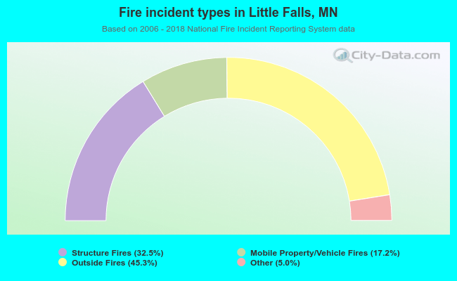 When looking into fire subcategories, the most reports belonged to: Outside Fires (45.3%), and Structure Fires (32.5%).
| Most common first names in Little Falls, MN among deceased individuals | ||
| Name | Count | Lived (average) |
|---|---|---|
| John | 144 | 79.7 years |
| Mary | 124 | 82.3 years |
| Frank | 90 | 81.0 years |
| Joseph | 85 | 79.4 years |
| Robert | 68 | 70.1 years |
| William | 63 | 79.5 years |
| Anna | 60 | 86.3 years |
| George | 60 | 80.1 years |
| Helen | 55 | 80.8 years |
| Leo | 54 | 77.1 years |
| Most common last names in Little Falls, MN among deceased individuals | ||
| Last name | Count | Lived (average) |
|---|---|---|
| Johnson | 73 | 79.6 years |
| Nelson | 60 | 79.6 years |
| Anderson | 58 | 79.1 years |
| Larson | 40 | 80.0 years |
| Ringwelski | 34 | 77.9 years |
| Miller | 33 | 81.5 years |
| Olson | 28 | 79.2 years |
| Peterson | 26 | 79.3 years |
| Czech | 23 | 83.9 years |
| Smith | 23 | 76.4 years |
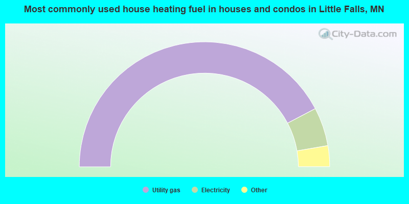
- 84.6%Utility gas
- 10.0%Electricity
- 1.9%Bottled, tank, or LP gas
- 1.3%Other fuel
- 0.9%Wood
- 0.7%Fuel oil, kerosene, etc.
- 0.6%No fuel used
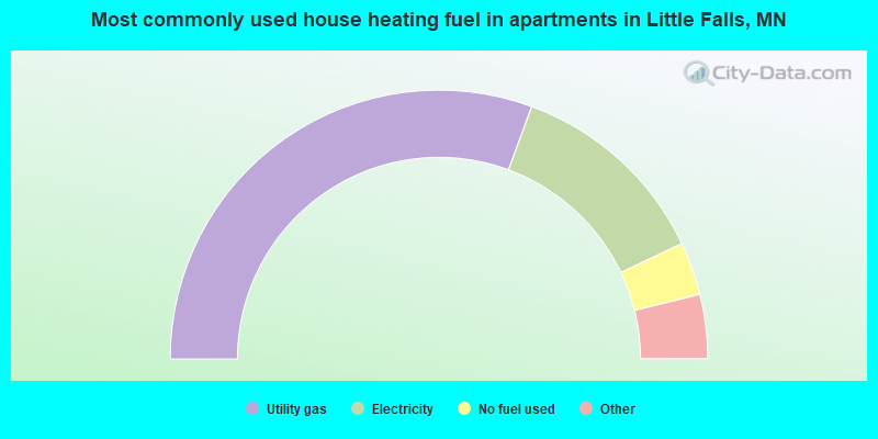
- 61.3%Utility gas
- 24.7%Electricity
- 6.4%No fuel used
- 3.0%Bottled, tank, or LP gas
- 2.5%Wood
- 1.1%Fuel oil, kerosene, etc.
- 1.1%Other fuel
Little Falls compared to Minnesota state average:
- Median household income below state average.
- Median house value below state average.
- Unemployed percentage below state average.
- Black race population percentage significantly below state average.
- Hispanic race population percentage significantly below state average.
- Foreign-born population percentage significantly below state average.
- Length of stay since moving in above state average.
- Institutionalized population percentage above state average.
- Number of college students below state average.
Little Falls on our top lists:
- #26 on the list of "Top 101 cities with the largest percentage of people in homes for the mentally retarded (population 1,000+)"
- #48 on the list of "Top 101 cities with largest percentage of females in occupations: material moving occupations (population 5,000+)"
- #65 on the list of "Top 101 cities with the largest percentage of people in religious group quarters (population 1,000+)"

|
|
Total of 30 patent applications in 2008-2024.