Menifee, California
Submit your own pictures of this city and show them to the world
- OSM Map
- Google Map
- MSN Map
| Males: 53,595 | |
| Females: 55,804 |
| Median resident age: | 37.2 years |
| California median age: | 37.9 years |
| Menifee: | $86,748 |
| CA: | $91,551 |
Estimated per capita income in 2022: $35,468
Menifee city income, earnings, and wages data
Estimated median house or condo value in 2022: $555,400
| Menifee: | $555,400 |
| CA: | $715,900 |
Mean prices in 2022: all housing units: $586,167; detached houses: $631,165; townhouses or other attached units: $625,082; in 2-unit structures: $464,831; in 3-to-4-unit structures: $482,529; in 5-or-more-unit structures: $526,423; mobile homes: $178,284; occupied boats, rvs, vans, etc.: $86,227
Median gross rent in 2022: $1,896.
(6.8% for White Non-Hispanic residents, 14.1% for Black residents, 10.4% for Hispanic or Latino residents, 0.4% for American Indian residents, 0.2% for Native Hawaiian and other Pacific Islander residents, 14.4% for other race residents, 6.8% for two or more races residents)
Detailed information about poverty and poor residents in Menifee, CA


Compare current foreclosures in Menifee, CA:
| Photo | Address | Area | Beds / Baths | Price | Details |
|---|---|---|---|---|---|

|
#1
Piazza Ct
Menifee, CA 92584
|
- sq. feet
|
2 baths 4 beds |
show details | |

|
#2
Tierra Shores Ln
Menifee, CA 92584
|
1,979 sq. feet
|
2 baths 3 beds |
show details | |

|
#3
Green Branch St
Menifee, CA 92584
|
3,090 sq. feet
|
2 baths 3 beds |
show details | |

|
#4
Westlake Dr
Menifee, CA 92584
|
1,746 sq. feet
|
2 baths 3 beds |
show details | |

|
#5
Cypress View Ct
Menifee, CA 92584
|
2,839 sq. feet
|
3 baths 5 beds |
show details | |

|
#6
Saddleback Ln
Menifee, CA 92584
|
1,536 sq. feet
|
2 baths 3 beds |
show details | |

|
#7
Murrieta Rd
Menifee, CA 92584
|
1,440 sq. feet
|
2 baths 2 beds |
show details | |

|
#8
Woodchester Way
Menifee, CA 92584
|
2,877 sq. feet
|
2 baths 4 beds |
show details | |

|
#9
Manzanita Rd
Menifee, CA 92584
|
1,344 sq. feet
|
2 baths 2 beds |
show details | |

|
#10
Highland Ct
Menifee, CA 92584
|
2,162 sq. feet
|
2 baths 3 beds |
show details |
| Photo | Address | Area | Beds / Baths | Price | Details |
|---|---|---|---|---|---|

|
#11
Sunset Ave
Menifee, CA 92584
|
2,037 sq. feet
|
2 baths 2 beds |
show details | |

|
#12
Saint Andrews Dr
Menifee, CA 92584
|
1,466 sq. feet
|
2 baths 3 beds |
show details | |

|
#13
Aspenwood Way
Menifee, CA 92584
|
2,100 sq. feet
|
3 baths 4 beds |
show details | |

|
#14
Falcon Hill Dr
Menifee, CA 92584
|
1,953 sq. feet
|
2 baths 4 beds |
show details | |

|
#15
Clear Canyon Cir
Menifee, CA 92584
|
2,886 sq. feet
|
2 baths 3 beds |
show details | |

|
#16
Twain Dr
Menifee, CA 92584
|
1,967 sq. feet
|
2 baths 4 beds |
show details | |

|
#17
Wildflower St
Menifee, CA 92584
|
2,000 sq. feet
|
2 baths 4 beds |
show details | |

|
#18
Brentworth St
Menifee, CA 92584
|
2,369 sq. feet
|
3 baths 4 beds |
show details | |

|
#19
Freedom Ln
Menifee, CA 92584
|
2,572 sq. feet
|
3 baths 3 beds |
show details | |

|
#20
Corte Suerte
Menifee, CA 92584
|
1,449 sq. feet
|
2 baths 3 beds |
show details |
| Photo | Address | Area | Beds / Baths | Price | Details |
|---|---|---|---|---|---|

|
#21
Fitzgerald Pl
Menifee, CA 92584
|
1,409 sq. feet
|
2 baths 3 beds |
show details | |

|
#22
Via Palermo
Menifee, CA 92584
|
1,643 sq. feet
|
2 baths 3 beds |
show details | |

|
#23
Windsail Ct
Menifee, CA 92584
|
1,502 sq. feet
|
2 baths 3 beds |
show details | |

|
#24
Green Branch St
Menifee, CA 92584
|
3,090 sq. feet
|
2 baths 3 beds |
show details | |

|
#25
Swift St
Menifee, CA 92584
|
2,357 sq. feet
|
3 baths 5 beds |
show details | |

|
#26
Napa St
Menifee, CA 92584
|
1,342 sq. feet
|
2 baths 3 beds |
show details | |

|
#27
Camino Cristal
Menifee, CA 92584
|
2,337 sq. feet
|
2 baths 5 beds |
show details | |

|
#28
Hayden Ln
Menifee, CA 92584
|
- sq. feet
|
- baths - beds |
$21,895
|
show details |

|
#29
Blue Water Way
Menifee, CA 92584
|
1,814 sq. feet
|
2 baths 2 beds |
show details | |

|
#30
Via Marsala
Menifee, CA 92584
|
1,777 sq. feet
|
3 baths 4 beds |
show details |
| Photo | Address | Area | Beds / Baths | Price | Details |
|---|---|---|---|---|---|

|
#31
Breighton Wood St
Menifee, CA 92584
|
3,393 sq. feet
|
2 baths 5 beds |
show details | |

|
#32
Sea Breeze Way
Menifee, CA 92584
|
3,267 sq. feet
|
3 baths 5 beds |
show details | |

|
#33
Briarwood Cir
Menifee, CA 92584
|
- sq. feet
|
- baths - beds |
show details | |

|
#34
Deer Run St
Menifee, CA 92584
|
- sq. feet
|
- baths - beds |
show details | |

|
#35
Hanover Ln Apt 3203
Menifee, CA 92584
|
- sq. feet
|
- baths - beds |
show details | |

|
#36
Hidden Meadow Dr
Menifee, CA 92584
|
- sq. feet
|
- baths - beds |
show details | |

|
#37
Oaktree Ln
Menifee, CA 92584
|
- sq. feet
|
- baths - beds |
show details | |

|
#38
Hidden Meadow Dr
Menifee, CA 92584
|
- sq. feet
|
- baths - beds |
show details | |

|
#39
Newport Rd Ste 1
Menifee, CA 92584
|
- sq. feet
|
- baths - beds |
show details | |

|
#40
Saddlehorn Way
Menifee, CA 92584
|
- sq. feet
|
- baths - beds |
show details |
| Photo | Address | Area | Beds / Baths | Price | Details |
|---|---|---|---|---|---|

|
#41
Comanche Creek Dr
Menifee, CA 92584
|
- sq. feet
|
- baths - beds |
show details | |

|
#42
Amber Mountain St
Menifee, CA 92584
|
- sq. feet
|
- baths - beds |
show details | |

|
#43
Antelope Valley Rd, Ste D #612
Menifee, CA 92584
|
- sq. feet
|
- baths - beds |
show details | |

|
#44
Carob Tree Cir
Menifee, CA 92584
|
- sq. feet
|
- baths - beds |
show details | |

|
#45
Holsteiner Way
Menifee, CA 92584
|
- sq. feet
|
- baths - beds |
show details | |

|
#46
Cherry Opal Ln
Menifee, CA 92584
|
- sq. feet
|
- baths - beds |
show details | |

|
#47
First Star Ct
Menifee, CA 92584
|
- sq. feet
|
- baths - beds |
show details | |

|
#48
Haun Rd # 1037
Menifee, CA 92584
|
- sq. feet
|
- baths - beds |
show details | |

|
#49
Hitch Rail Ln
Menifee, CA 92584
|
- sq. feet
|
- baths - beds |
show details | |

|
Check over 1 million property listings on Foreclosure.com!
|
browse all offers | |||


- 44,78740.9%White alone
- 39,41636.0%Hispanic
- 9,2868.5%Black alone
- 8,4577.7%Asian alone
- 5,5675.1%Two or more races
- 1,6851.5%Other race alone
- 1090.10%Native Hawaiian and Other
Pacific Islander alone - 920.08%American Indian alone
According to our research of California and other state lists, there were 108 registered sex offenders living in Menifee, California as of April 28, 2024.
The ratio of all residents to sex offenders in Menifee is 820 to 1.
The ratio of registered sex offenders to all residents in this city is near the state average.
Full-time law enforcement employees in 2021, including police officers: 94 (67 officers - 58 male; 9 female).
| Officers per 1,000 residents here: | 0.67 |
| California average: | 2.30 |
 Recent articles from our blog. Our writers, many of them Ph.D. graduates or candidates, create easy-to-read articles on a wide variety of topics.
Ancestries: English (4.4%), American (3.6%), German (3.6%), Irish (3.1%), Italian (2.9%), European (2.9%).
Current Local Time: PST time zone
Elevation: 1479 feet
16,203 residents are foreign born (9.3% Latin America, 3.9% Asia).
| This city: | 15.3% |
| California: | 26.5% |
Median real estate property taxes paid for housing units with mortgages in 2022: $4,871 (0.9%)
Median real estate property taxes paid for housing units with no mortgage in 2022: $3,349 (0.7%)
Nearest city with pop. 200,000+: Riverside, CA  (20.9 miles , pop. 255,166).
Nearest city with pop. 1,000,000+: San Diego, CA (65.6 miles , pop. 1,223,400).
Nearest cities:
), ), Latitude: 33.73 N, Longitude: 117.15 W
Area code commonly used in this area: 909
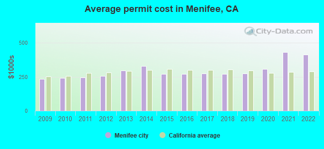
Single-family new house construction building permits:
- 2022: 904 buildings, average cost: $413,400
- 2021: 1264 buildings, average cost: $432,200
- 2020: 1410 buildings, average cost: $309,100
- 2019: 1017 buildings, average cost: $274,900
- 2018: 976 buildings, average cost: $270,900
- 2017: 717 buildings, average cost: $274,600
- 2016: 565 buildings, average cost: $272,200
- 2015: 408 buildings, average cost: $270,400
- 2014: 490 buildings, average cost: $329,300
- 2013: 374 buildings, average cost: $298,000
- 2012: 348 buildings, average cost: $257,600
- 2011: 283 buildings, average cost: $243,600
- 2010: 399 buildings, average cost: $240,000
- 2009: 332 buildings, average cost: $236,200
| Here: | 5.4% |
| California: | 5.1% |
(lower is better)
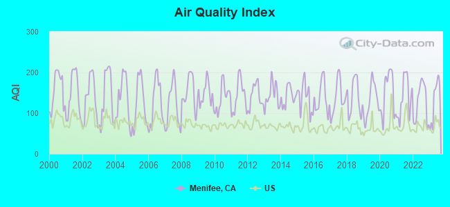
Air Quality Index (AQI) level in 2023 was 131. This is significantly worse than average.
| City: | 131 |
| U.S.: | 73 |
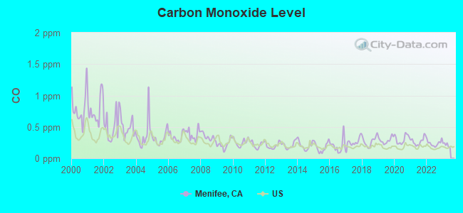
Carbon Monoxide (CO) [ppm] level in 2022 was 0.239. This is about average. Closest monitor was 6.3 miles away from the city center.
| City: | 0.239 |
| U.S.: | 0.251 |
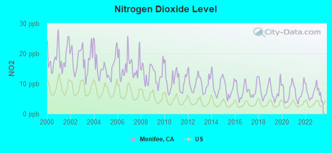
Nitrogen Dioxide (NO2) [ppb] level in 2022 was 7.13. This is worse than average. Closest monitor was 6.3 miles away from the city center.
| City: | 7.13 |
| U.S.: | 5.11 |
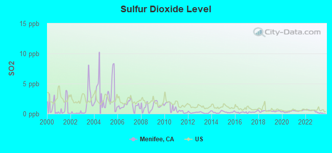
Sulfur Dioxide (SO2) [ppb] level in 2022 was 0.541. This is significantly better than average. Closest monitor was 20.9 miles away from the city center.
| City: | 0.541 |
| U.S.: | 1.515 |
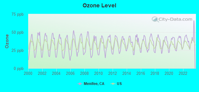
Ozone [ppb] level in 2023 was 42.1. This is worse than average. Closest monitor was 6.3 miles away from the city center.
| City: | 42.1 |
| U.S.: | 33.3 |
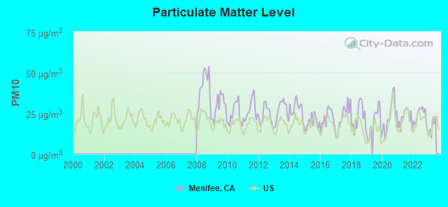
Particulate Matter (PM10) [µg/m3] level in 2022 was 23.2. This is worse than average. Closest monitor was 6.3 miles away from the city center.
| City: | 23.2 |
| U.S.: | 19.2 |
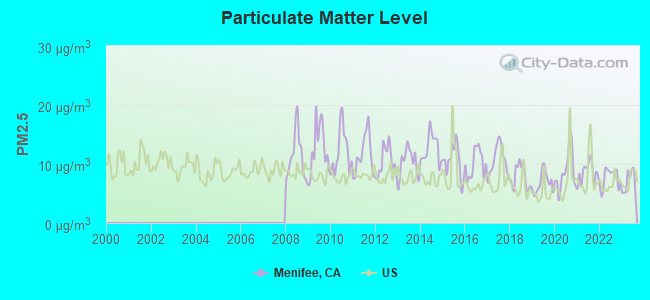
Particulate Matter (PM2.5) [µg/m3] level in 2023 was 6.95. This is about average. Closest monitor was 19.7 miles away from the city center.
| City: | 6.95 |
| U.S.: | 8.11 |
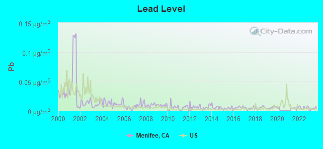
Lead (Pb) [µg/m3] level in 2023 was 0.00426. This is significantly better than average. Closest monitor was 6.3 miles away from the city center.
| City: | 0.00426 |
| U.S.: | 0.00931 |
Earthquake activity:
Menifee-area historical earthquake activity is significantly above California state average. It is 7034% greater than the overall U.S. average.On 6/28/1992 at 11:57:34, a magnitude 7.6 (6.2 MB, 7.6 MS, 7.3 MW, Depth: 0.7 mi, Class: Major, Intensity: VIII - XII) earthquake occurred 47.2 miles away from Menifee center, causing 3 deaths (1 shaking deaths, 2 other deaths) and 400 injuries, causing $100,000,000 total damage and $40,000,000 insured losses
On 7/21/1952 at 11:52:14, a magnitude 7.7 (7.7 UK) earthquake occurred 137.6 miles away from the city center, causing $50,000,000 total damage
On 10/16/1999 at 09:46:44, a magnitude 7.4 (6.3 MB, 7.4 MS, 7.2 MW, 7.3 ML) earthquake occurred 67.9 miles away from the city center
On 5/19/1940 at 04:36:40, a magnitude 7.2 (7.2 UK) earthquake occurred 90.6 miles away from the city center, causing $33,000,000 total damage
On 6/28/1992 at 15:05:30, a magnitude 6.9 (6.3 MB, 6.7 MS, 6.5 MW, 6.9 ME, Depth: 3.1 mi, Class: Strong, Intensity: VII - IX) earthquake occurred 43.1 miles away from the city center
On 4/21/1918 at 22:32:30, a magnitude 6.8 (6.8 UK) earthquake occurred 17.9 miles away from Menifee center
Magnitude types: body-wave magnitude (MB), energy magnitude (ME), local magnitude (ML), surface-wave magnitude (MS), moment magnitude (MW)
Natural disasters:
The number of natural disasters in Riverside County (46) is a lot greater than the US average (15).Major Disasters (Presidential) Declared: 27
Emergencies Declared: 1
Causes of natural disasters: Fires: 22, Floods: 20, Storms: 8, Winter Storms: 8, Landslides: 6, Mudslides: 5, Heavy Rains: 2, Earthquake: 1, Flash Flood: 1, Freeze: 1, Hurricane: 1, Tornado: 1, Tropical Storm: 1, Other: 1 (Note: some incidents may be assigned to more than one category).
Hospitals and medical centers in Menifee:
Other hospitals and medical centers near Menifee:
- LIFE CARE CENTER OF MENIFEE (Nursing Home, about 3 miles away; SUN CITY, CA)
- HOSPICE OF THE VALLEYS (Hospital, about 3 miles away; SUN CITY, CA)
- HOPE HOSPICE AND HEALTHCARE, INC (Hospital, about 4 miles away; SUN CITY, CA)
- CENTINELA GRAND INC (Nursing Home, about 8 miles away; PERRIS, CA)
- LOMA LINDA UNIVERSITY MEDICAL CENTER-MURRIETA Acute Care Hospitals (about 9 miles away; MURRIETA, CA)
- DAVITA-HEMET (Dialysis Facility, about 9 miles away; HEMET, CA)
- THE VILLAGE HEALTHCARE CENTER (Nursing Home, about 9 miles away; HEMET, CA)
Colleges/universities with over 2000 students nearest to Menifee:
- Mt San Jacinto Community College District (about 12 miles; San Jacinto, CA; Full-time enrollment: 8,426)
- Moreno Valley College (about 12 miles; Moreno Valley, CA; FT enrollment: 4,650)
- University of California-Riverside (about 21 miles; Riverside, CA; FT enrollment: 20,647)
- California Baptist University (about 22 miles; Riverside, CA; FT enrollment: 6,085)
- Riverside City College (about 22 miles; Riverside, CA; FT enrollment: 10,661)
- Crafton Hills College (about 22 miles; Yucaipa, CA; FT enrollment: 3,222)
- University of Redlands (about 24 miles; Redlands, CA; FT enrollment: 4,854)
Public high schools in Menifee:
- PALOMA VALLEY HIGH (Students: 1,899, Location: 31375 BRADLEY RD., Grades: 9-12)
- SANTA ROSA ACADEMY (Students: 306, Location: 27587 LA PIEDRA RD., Grades: KG-12, Charter school)
Biggest public elementary/middle schools in Menifee:
- BELL MOUNTAIN MIDDLE (Students: 1,375, Location: 28525 LA PIEDRA DR., Grades: 6-8)
- MENIFEE VALLEY MIDDLE (Students: 1,320, Location: 26255 GARBANI RD., Grades: 6-8)
- HANS CHRISTENSEN MIDDLE (Students: 842, Location: 27625 SHERMAN RD., Grades: 6-8)
- FREEDOM CREST ELEMENTARY (Students: 489, Location: 29282 MENIFEE RD., Grades: KG-5)
- CHESTER W. MORRISON ELEMENTARY (Students: 481, Location: 30250 BRADLEY RD., Grades: KG-5)
- SOUTHSHORE ELEMENTARY (Students: 408, Location: 30975 S.SHORE DR., Grades: KG-5)
- EVANS RANCH ELEMENTARY (Students: 407, Location: 30465 EVANS RD., Grades: KG-5)
- CALLIE KIRKPATRICK ELEMENTARY (Students: 406, Location: 28800 REVIERE DR., Grades: KG-5)
- ETHAN A CHASE MIDDLE (Location: 28100 CALM HORIZON DR., Grades: 6-8)
- BOULDER RIDGE ELEMENTARY (Location: 27327 JUNIPER RD., Grades: KG-5)
Private elementary/middle school in Menifee:
Points of interest:
Notable locations in Menifee: Menifee-Antelope Community Hall (A), Ethanac Siding (B), Sun City Golf Club North Course (C), Sun City Golf Course (D), Menifee Lakes Country Club (E), Audie Murphy Ranch (F), Quail Valley Country Club (G), American Medical Response Sun City (H), Sun City Town Hall (I), Sun City Chamber of Commerce (J), Sun City Branch Riverside City and County Public Library (K), Riverside County Fire Department Station 68 Menifee (L), Riverside County Fire Department Station 5 - Quail Valley (M), Riverside County Fire Department Station 7 Sun City (N), Riverside County Fire Department Station 76 - Menifee Lakes (O). Display/hide their locations on the map
Shopping Centers: Sun City Shopping Center (1), Newport Plaza Shopping Center (2), Menifee Town Center Shopping Center (3). Display/hide their locations on the map
Churches in Menifee include: Church of Christ of the Valley (A), Faith Lutheran Church (B), Grace Evangelical Free Church (C), Temple Beth Sholom (D). Display/hide their locations on the map
Parks in Menifee include: Motte Field Park (1), Quail Valley Park (2). Display/hide their locations on the map
| This city: | 2.8 people |
| California: | 2.9 people |
| This city: | 70.9% |
| Whole state: | 68.7% |
| This city: | 5.6% |
| Whole state: | 7.2% |
Likely homosexual households (counted as self-reported same-sex unmarried-partner households)
- Lesbian couples: 0.4% of all households
- Gay men: 0.2% of all households
People in group quarters in Menifee in 2010:
- 106 people in nursing facilities/skilled-nursing facilities
- 45 people in workers' group living quarters and job corps centers
- 29 people in group homes intended for adults
- 5 people in residential treatment centers for adults
- 2 people in other noninstitutional facilities
Banks with branches in Menifee (2011 data):
- Union Bank, National Association: Menifee Instore Branch at 30125 Antelope Road, branch established on 1992/05/28. Info updated 2011/09/01: Bank assets: $88,967.5 mil, Deposits: $65,286.4 mil, headquarters in San Francisco, CA, positive income, Commercial Lending Specialization, 403 total offices, Holding Company: Mitsubishi Ufj Financial Group, Inc.
- Bank of America, National Association: Menifee Town Center Branch at 30187 Antelope Road, branch established on 2004/09/27. Info updated 2009/11/18: Bank assets: $1,451,969.3 mil, Deposits: $1,077,176.8 mil, headquarters in Charlotte, NC, positive income, 5782 total offices, Holding Company: Bank Of America Corporation
- JPMorgan Chase Bank, National Association: Newport & Haun Banking Center at 30032 Haun Rd, branch established on 2011/11/01. Info updated 2011/11/10: Bank assets: $1,811,678.0 mil, Deposits: $1,190,738.0 mil, headquarters in Columbus, OH, positive income, International Specialization, 5577 total offices, Holding Company: Jpmorgan Chase & Co.
- Wells Fargo Bank, National Association: Menifee Countryside Marketplace Bran at 30186 Haun Road, branch established on 2008/10/14. Info updated 2011/04/05: Bank assets: $1,161,490.0 mil, Deposits: $905,653.0 mil, headquarters in Sioux Falls, SD, positive income, 6395 total offices, Holding Company: Wells Fargo & Company
For population 15 years and over in Menifee:
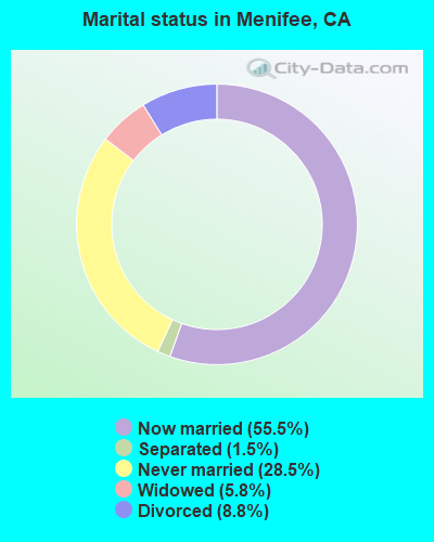
- Never married: 28.5%
- Now married: 55.5%
- Separated: 1.5%
- Widowed: 5.8%
- Divorced: 8.8%
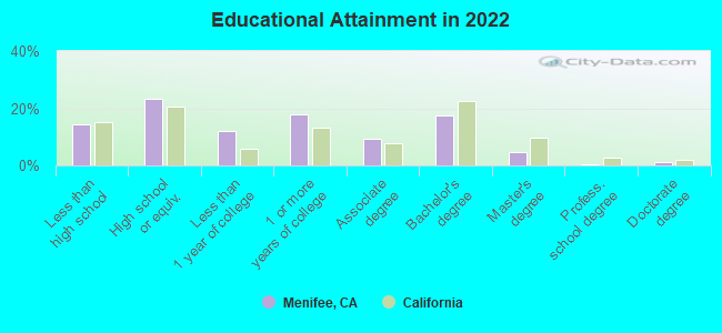
For population 25 years and over in Menifee:
- High school or higher: 85.7%
- Bachelor's degree or higher: 23.4%
- Graduate or professional degree: 6.0%
- Unemployed: 4.8%
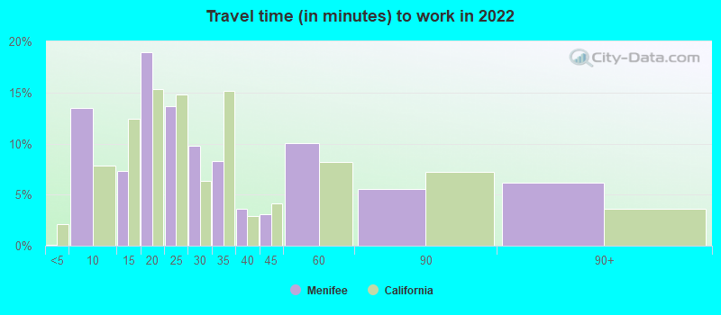
- Mean travel time to work (commute): 34.3 minutes
| Here: | 12.3 |
| California average: | 15.5 |
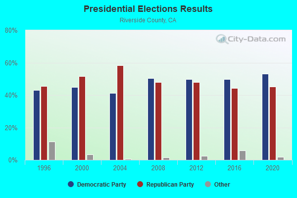
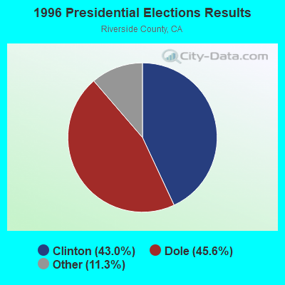
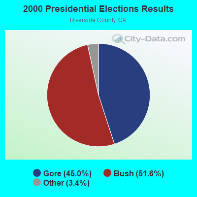
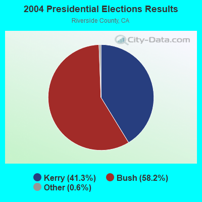
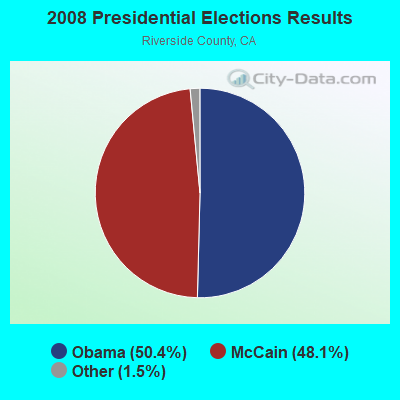
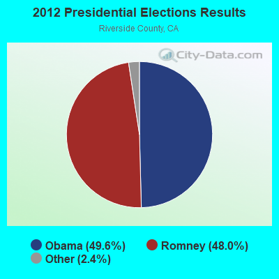
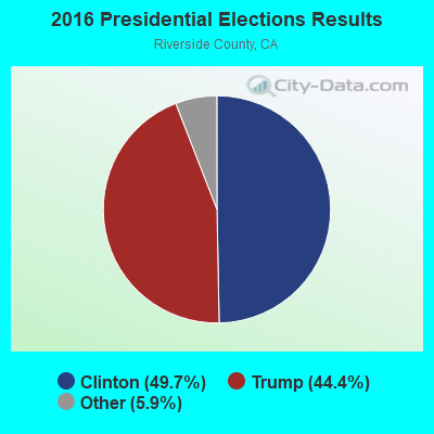
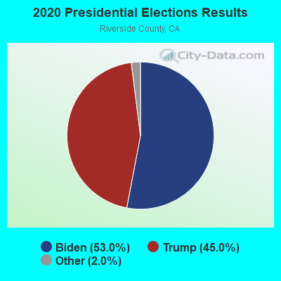
Graphs represent county-level data. Detailed 2008 Election Results
Religion statistics for Menifee, CA (based on Riverside County data)
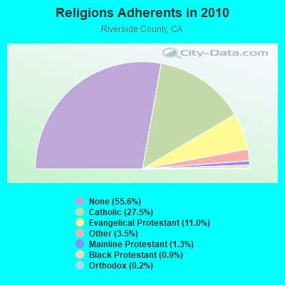
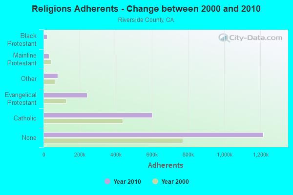
| Religion | Adherents | Congregations |
|---|---|---|
| Catholic | 602,765 | 51 |
| Evangelical Protestant | 240,306 | 741 |
| Other | 77,581 | 194 |
| Mainline Protestant | 29,535 | 103 |
| Black Protestant | 19,170 | 40 |
| Orthodox | 3,647 | 11 |
| None | 1,216,637 | - |
Food Environment Statistics:
| This county: | 1.60 / 10,000 pop. |
| California: | 2.14 / 10,000 pop. |
| This county: | 0.05 / 10,000 pop. |
| State: | 0.04 / 10,000 pop. |
| Riverside County: | 0.44 / 10,000 pop. |
| State: | 0.62 / 10,000 pop. |
| This county: | 1.51 / 10,000 pop. |
| State: | 1.49 / 10,000 pop. |
| This county: | 5.45 / 10,000 pop. |
| California: | 7.42 / 10,000 pop. |
| Riverside County: | 7.7% |
| California: | 7.3% |
| Here: | 24.5% |
| California: | 21.3% |
| Riverside County: | 15.2% |
| California: | 17.9% |
| Local government employment and payroll (March 2022) | |||||
| Function | Full-time employees | Monthly full-time payroll | Average yearly full-time wage | Part-time employees | Monthly part-time payroll |
|---|---|---|---|---|---|
| Police Protection - Officers | 77 | $820,578 | $127,882 | 1 | $1,887 |
| Streets and Highways | 35 | $259,128 | $88,844 | 0 | $0 |
| Other Government Administration | 27 | $179,299 | $79,688 | 0 | $0 |
| Police - Other | 26 | $162,881 | $75,176 | 0 | $0 |
| Financial Administration | 24 | $189,693 | $94,847 | 0 | $0 |
| Parks and Recreation | 20 | $146,611 | $87,967 | 42 | $57,250 |
| Housing and Community Development (Local) | 19 | $166,365 | $105,073 | 2 | $5,112 |
| Other and Unallocable | 13 | $98,814 | $91,213 | 0 | $0 |
| Fire - Other | 2 | $21,575 | $129,450 | 0 | $0 |
| Totals for Government | 243 | $2,044,943 | $100,985 | 45 | $64,250 |
Menifee government finances - Expenditure in 2018 (per resident):
- Construction - Regular Highways: $13,997,000 ($127.94)
Protective Inspection and Regulation - Other: $1,441,000 ($13.17)
Local Fire Protection: $302,000 ($2.76)
Health - Other: $139,000 ($1.27)
- Current Operations - Police Protection: $13,937,000 ($127.40)
Local Fire Protection: $10,697,000 ($97.78)
Central Staff Services: $7,306,000 ($66.78)
Regular Highways: $4,135,000 ($37.80)
Protective Inspection and Regulation - Other: $3,912,000 ($35.76)
Housing and Community Development: $3,745,000 ($34.23)
Financial Administration: $967,000 ($8.84)
Judicial and Legal Services: $765,000 ($6.99)
Parks and Recreation: $530,000 ($4.84)
Health - Other: $425,000 ($3.88)
Libraries: $50,000 ($0.46)
- General - Interest on Debt: $1,822,000 ($16.65)
- Intergovernmental to Local - Other - Police Protection: $10,984,000 ($100.40)
Other - Local Fire Protection: $10,315,000 ($94.29)
Other - General - Other: $3,418,000 ($31.24)
Other - Regular Highways: $3,253,000 ($29.74)
Other - Correctional Institutions: $128,000 ($1.17)
Other - Health - Other: $106,000 ($0.97)
Other - Natural Resources - Other: $101,000 ($0.92)
- Other Capital Outlay - Police Protection: $770,000 ($7.04)
Housing and Community Development: $590,000 ($5.39)
Parks and Recreation: $43,000 ($0.39)
Menifee government finances - Revenue in 2018 (per resident):
- Charges - Other: $11,696,000 ($106.91)
Parks and Recreation: $316,000 ($2.89)
- Federal Intergovernmental - Other: $258,000 ($2.36)
- Local Intergovernmental - Other: $1,084,000 ($9.91)
- Miscellaneous - Special Assessments: $7,788,000 ($71.19)
General Revenue - Other: $1,499,000 ($13.70)
Fines and Forfeits: $1,237,000 ($11.31)
Interest Earnings: $396,000 ($3.62)
Rents: $39,000 ($0.36)
Donations From Private Sources: $35,000 ($0.32)
- State Intergovernmental - Other: $2,336,000 ($21.35)
Highways: $2,326,000 ($21.26)
General Local Government Support: $1,219,000 ($11.14)
- Tax - General Sales and Gross Receipts: $19,670,000 ($179.80)
Property: $18,800,000 ($171.85)
Other License: $6,034,000 ($55.16)
Public Utilities Sales: $3,110,000 ($28.43)
Documentary and Stock Transfer: $615,000 ($5.62)
Other Selective Sales: $232,000 ($2.12)
Occupation and Business License - Other: $116,000 ($1.06)
Menifee government finances - Debt in 2018 (per resident):
- Long Term Debt - Beginning Outstanding - Unspecified Public Purpose: $19,030,000 ($173.95)
Outstanding Unspecified Public Purpose: $17,860,000 ($163.26)
Retired Unspecified Public Purpose: $1,170,000 ($10.69)
Menifee government finances - Cash and Securities in 2018 (per resident):
- Bond Funds - Cash and Securities: $4,914,000 ($44.92)
- Other Funds - Cash and Securities: $74,718,000 ($682.99)
- Sinking Funds - Cash and Securities: $1,370,000 ($12.52)
7.19% of this county's 2021 resident taxpayers lived in other counties in 2020 ($71,521 average adjusted gross income)
| Here: | 7.19% |
| California average: | 5.19% |
0.03% of residents moved from foreign countries ($210 average AGI)
Riverside County: 0.03% California average: 0.03%
Top counties from which taxpayers relocated into this county between 2020 and 2021:
| from Los Angeles County, CA | |
| from San Bernardino County, CA | |
| from Orange County, CA |
6.28% of this county's 2020 resident taxpayers moved to other counties in 2021 ($64,593 average adjusted gross income)
| Here: | 6.28% |
| California average: | 6.14% |
0.02% of residents moved to foreign countries ($200 average AGI)
Riverside County: 0.02% California average: 0.02%
Top counties to which taxpayers relocated from this county between 2020 and 2021:
| to San Bernardino County, CA | |
| to Los Angeles County, CA | |
| to Orange County, CA |
| Businesses in Menifee, CA | ||||
| Name | Count | Name | Count | |
|---|---|---|---|---|
| AT&T | 1 | Motel 6 | 1 | |
| AutoZone | 1 | New Balance | 2 | |
| Baskin-Robbins | 1 | Nike | 1 | |
| Blockbuster | 1 | Old Navy | 1 | |
| Chipotle | 1 | Panda Express | 1 | |
| Circle K | 1 | Payless | 1 | |
| DHL | 1 | RadioShack | 1 | |
| Decora Cabinetry | 1 | Red Robin | 1 | |
| Famous Footwear | 1 | Rite Aid | 2 | |
| FedEx | 2 | Staples | 1 | |
| GNC | 1 | Starbucks | 2 | |
| GameStop | 1 | T-Mobile | 3 | |
| H&R Block | 1 | T.J.Maxx | 1 | |
| IHOP | 1 | Taco Bell | 1 | |
| Jack In The Box | 2 | Target | 1 | |
| Kohl's | 1 | U-Haul | 3 | |
| Kroger | 1 | UPS | 5 | |
| Lane Bryant | 1 | Verizon Wireless | 2 | |
| Lowe's | 1 | Walgreens | 1 | |
| MasterBrand Cabinets | 1 | |||
Strongest AM radio stations in Menifee:
- KPLS (830 AM; 50 kW; ORANGE, CA; Owner: CRN LICENSES, LLC)
- KFI (640 AM; 50 kW; LOS ANGELES, CA; Owner: CAPSTAR TX LIMITED PARTNERSHIP)
- KLAC (570 AM; 50 kW; LOS ANGELES, CA; Owner: AMFM RADIO LICENSES, L.L.C.)
- KTNQ (1020 AM; 50 kW; LOS ANGELES, CA; Owner: KTNQ-AM LICENSE CORP.)
- KFMB (760 AM; 50 kW; SAN DIEGO, CA; Owner: MIDWEST TELEVISION, INC.)
- KHPY (1670 AM; 10 kW; MORENO VALLEY, CA; Owner: DELBERT L. VAN VOORHIS)
- KXTA (1150 AM; 50 kW; LOS ANGELES, CA; Owner: CITICASTERS LICENSES, L.P.)
- KDIS (1110 AM; 50 kW; PASADENA, CA; Owner: ABC,INC.)
- KFWB (980 AM; 50 kW; LOS ANGELES, CA; Owner: INFINITY BROADCASTING OPERATIONS, INC.)
- KCBQ (1170 AM; 50 kW; SAN DIEGO, CA; Owner: RADIO 1210, INC.)
- KSPN (710 AM; 50 kW; LOS ANGELES, CA; Owner: KABC-AM RADIO, INC.)
- KNX (1070 AM; 50 kW; LOS ANGELES, CA; Owner: INFINITY BROADCASTING OPERATIONS, INC.)
- KSDT (1320 AM; 1 kW; HEMET, CA; Owner: RUDEX BROADCASTING LIMITED)
Strongest FM radio stations in Menifee:
- KRTM (88.9 FM; TEMECULA, CA; Owner: PENFOLD COMMUNICATIONS, INC.)
- KXFG (92.9 FM; SUN CITY, CA; Owner: INFINITY RADIO OPERATIONS INC.)
- KLRD (90.1 FM; YUCAIPA, CA; Owner: EDUCATIONAL MEDIA FOUNDATION)
- KWRP (96.1 FM; SAN JACINTO, CA; Owner: MAGIC BROADCASTING, INC.)
- KPLM-FM2 (106.1 FM; SAN JACINTO, CA; Owner: RM BROADCASTING L.L.C.)
- KUOR-FM (89.1 FM; REDLANDS, CA; Owner: UNIVERSITY OF REDLANDS)
- KXRS (105.7 FM; HEMET, CA; Owner: LAZER BROADCASTING CORPORATION)
- KWVE (107.9 FM; SAN CLEMENTE, CA; Owner: CALVARY CHAPEL OF COSTA MESA)
- KOLA (99.9 FM; SAN BERNARDINO, CA; Owner: INLAND EMPIRE BROADCASTING CORP.)
- KVCR (91.9 FM; SAN BERNARDINO, CA; Owner: SAN BERNARDINO COMMUNITY COLLEGE DISTRICT)
- KUCR (88.3 FM; RIVERSIDE, CA; Owner: THE REGENTS OF THE UNIV. OF CA)
- K201AR (88.1 FM; BANNING, CA; Owner: KSGN, INC.)
- K232CX (94.3 FM; DESERT HOT SPRINGS, CA; Owner: MCC RADIO, LLC)
- KATY-FM (101.3 FM; IDYLLWILD, CA; Owner: ALL PRO BROADCASTING, INC.)
- KCXX (103.9 FM; LAKE ARROWHEAD, CA; Owner: ALL-PRO BROADCASTING, INC.)
- K295AI (106.9 FM; MUSCOY, CA; Owner: ASSOCIATION FOR COMMUNITY EDUCATION, INC.)
- KGBB (103.3 FM; TEMECULA, CA; Owner: CLEAR CHANNEL BROADCASTING LICENSES, INC.)
- KMYT (94.5 FM; TEMECULA, CA; Owner: CLEAR CHANNEL BROADCASTING LICENSES, INC.)
- KGGI (99.1 FM; RIVERSIDE, CA; Owner: AMFM RADIO LICENSES, L.L.C.)
- KLYY (97.5 FM; RIVERSIDE, CA; Owner: ENTRAVISION HOLDINGS, LLC)
TV broadcast stations around Menifee:
- KTRO-LP (Channel 50; LANCASTER, CA; Owner: ROBERT D. ADELMAN)
- KHIZ (Channel 64; BARSTOW, CA; Owner: SUNBELT TELEVISION, INC.)
- KVCR-TV (Channel 24; SAN BERNARDINO, CA; Owner: SAN BERNARDINO COMMUNITY COLLEGE DISTRICT)
- K47FL (Channel 47; FALLBROOK, CA; Owner: CHANNEL 51 OF SAN DIEGO, INC.)
- National Bridge Inventory (NBI) Statistics
- 6Number of bridges
- 98ft / 30.2mTotal length
- 122,359Total average daily traffic
- 5,895Total average daily truck traffic
FCC Registered Broadcast Land Mobile Towers: 16 (See the full list of FCC Registered Broadcast Land Mobile Towers in Menifee, CA)
FCC Registered Microwave Towers: 11 (See the full list of FCC Registered Microwave Towers in this town)
FCC Registered Amateur Radio Licenses: 284 (See the full list of FCC Registered Amateur Radio Licenses in Menifee)
FAA Registered Aircraft Manufacturers and Dealers: 1 (See the full list of FAA Registered Manufacturers and Dealers in Menifee)
FAA Registered Aircraft: 27 (See the full list of FAA Registered Aircraft)
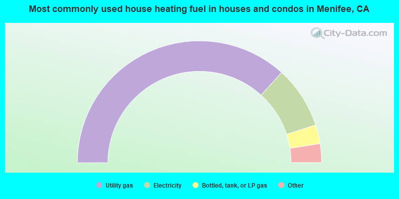
- 73.5%Utility gas
- 16.5%Electricity
- 5.0%Bottled, tank, or LP gas
- 3.8%Solar energy
- 0.6%No fuel used
- 0.3%Wood
- 0.2%Other fuel
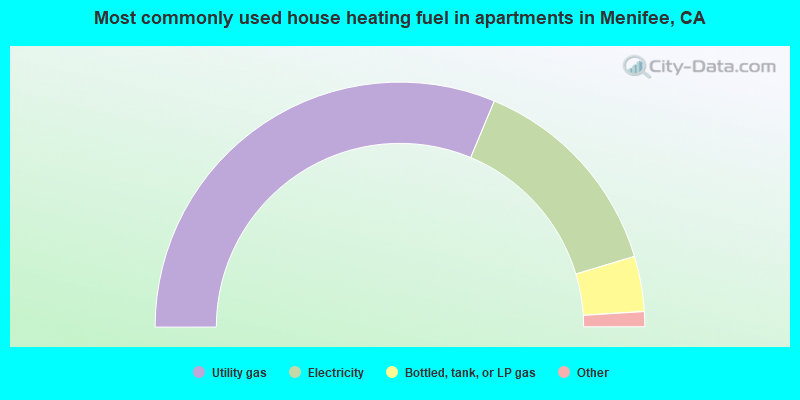
- 62.6%Utility gas
- 28.1%Electricity
- 7.3%Bottled, tank, or LP gas
- 1.6%No fuel used
- 0.3%Other fuel
Menifee compared to California state average:
- Unemployed percentage significantly below state average.
- Black race population percentage above state average.
- Median age above state average.
- Renting percentage below state average.
- Length of stay since moving in significantly below state average.
- House age significantly below state average.
Menifee on our top lists:
- #2 on the list of "Top 101 cities with the lowest city-data.com crime index (population 50,000+)"
- #2 on the list of "Top 101 cities with the largest differences between daily high and daily low temperatures (population 50,000+)"
- #7 on the list of "Top 101 cities with largest percentage of females in occupations: health technologists and technicians (population 50,000+)"
- #15 on the list of "Top 101 cities with the largest city-data.com crime index increase from 2011 to 2012 (population 50,000+)"
- #21 on the list of "Top 100 cities with longest commuting times (pop. 50,000+)"
- #23 on the list of "Top 101 cities with the lowest number of arson incidents per 100,000 residents (population 50,000+)"
- #23 on the list of "Top 101 cities with largest percentage of males in industries: utilities (population 50,000+)"
- #29 on the list of "Top 101 cities with largest percentage of females in occupations: sales and related occupations (population 50,000+)"
- #37 on the list of "Top 101 cities with the lowest number of rapes per 100,000 residents (population 50,000+)"
- #40 on the list of "Top 101 cities with the highest daily high temperatures (population 50,000+)"
- #45 on the list of "Top 101 cities with largest percentage of males in occupations: building and grounds cleaning and maintenance occupations (population 50,000+)"
- #48 on the list of "Top 101 cities with largest percentage of females in industries: arts, entertainment, and recreation (population 50,000+)"
- #54 on the list of "Top 100 low-educated but high-earning cities (pop. 50,000+)"
- #63 on the list of "Top 101 cities with the lowest average yearly precipitation (population 50,000+)"
- #65 on the list of "Top 101 cities with largest percentage of females in industries: public administration (population 50,000+)"
- #66 on the list of "Top 101 cities with largest percentage of females in industries: mining, quarrying, and oil and gas extraction (population 50,000+)"
- #69 on the list of "Top 101 cities with the least people having Doctorate degrees (population 50,000+)"
- #74 on the list of "Top 100 cities with newest houses (pop. 50,000+)"
- #81 on the list of "Top 101 cities with largest percentage of males in occupations: fire fighting and prevention workers including supervisors (population 50,000+)"
- #86 on the list of "Top 101 cities with largest percentage of males in industries: construction (population 50,000+)"
- #65 (92586) on the list of "Top 101 zip codes with the smallest percentage of returns reporting salary or wage in 2012 (pop 5,000+)"
- #3 on the list of "Top 101 counties with the highest lead air pollution readings in 2012 (µg/m3)"
- #4 on the list of "Top 101 counties with the highest ground withdrawal of fresh water for public supply"
- #11 on the list of "Top 101 counties with the most Catholic adherents"
- #11 on the list of "Top 101 counties with the highest total withdrawal of fresh water for public supply"
- #12 on the list of "Top 101 counties with the highest carbon monoxide air pollution readings in 2012 (ppm)"

|
|
Total of 120 patent applications in 2008-2024.