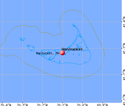
Nantucket, Massachusetts
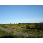
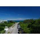
Nantucket: ON THE WAY TO MADAKET
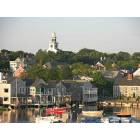
Nantucket: Sky Line
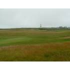
Nantucket: Sankaty lighthouse, Nantucket Island, MA
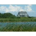
Nantucket: Madaket, Nantucket Island, MA
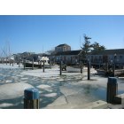
Nantucket: Winter - Nantucket
Nantucket: Scionsets Eastern most portions
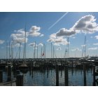
Nantucket: Boats - Nantucket

Nantucket: Squam Beach on the Eastern portion of Nantucket
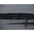
Nantucket: Brant Point's Fog light
- add
your
Submit your own pictures of this place and show them to the world
- OSM Map
- General Map
- Google Map
- MSN Map
Population change since 2000: +94.4%
| Males: 3,969 | |
| Females: 3,477 |
| Median resident age: | 40.2 years |
| Massachusetts median age: | 40.3 years |
Zip codes: 02554.
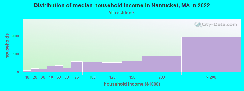
| Nantucket: | $128,983 |
| MA: | $94,488 |
Estimated per capita income in 2022: $57,373 (it was $29,497 in 2000)
Nantucket CDP income, earnings, and wages data
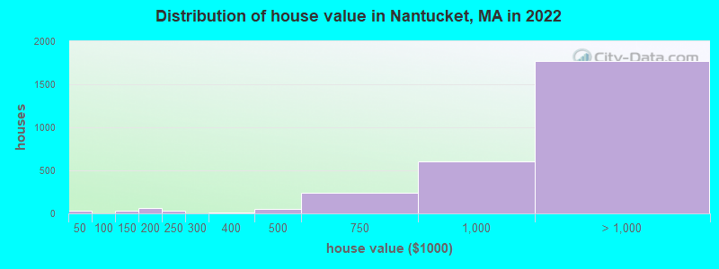
Estimated median house or condo value in 2022: over $1,000,000 (it was $554,000 in 2000)
| Nantucket: | over $1,000,000 |
| MA: | $534,700 |
Mean prices in 2022: all housing units: over $1,000,000; detached houses: over $1,000,000; townhouses or other attached units: $793,316; in 2-unit structures: over $1,000,000
Median gross rent in 2022: $2,409.
(4.7% for White Non-Hispanic residents, 3.4% for Black residents, 8.4% for Hispanic or Latino residents, 11.9% for other race residents, 1.6% for two or more races residents)
Detailed information about poverty and poor residents in Nantucket, MA


Compare current foreclosures near Nantucket, MA:
| Photo | Address | Area | Beds / Baths | Price | Details |
|---|---|---|---|---|---|

|
#1
S Cambridge St
Nantucket, MA 02554
|
1,280 sq. feet
|
2 baths 3 beds |
show details | |

|
#2
Brinda Ln
Nantucket, MA 02554
|
1,547 sq. feet
|
2 baths 3 beds |
show details | |

|
#3
Cow Pond Ln # B
Nantucket, MA 02554
|
- sq. feet
|
- baths - beds |
show details | |

|
#4
Old South Rd, Ste 333
Nantucket, MA 02554
|
- sq. feet
|
- baths - beds |
show details | |

|
Check over 1 million property listings on Foreclosure.com!
|
browse all offers | |||


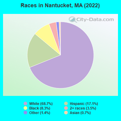
- 7,19568.7%White alone
- 1,79317.1%Hispanic
- 8678.3%Black alone
- 3663.5%Two or more races
- 1421.4%Other race alone
- 710.7%Asian alone
Races in Nantucket detailed stats: ancestries, foreign born residents, place of birth
According to our research of Massachusetts and other state lists, there were 5 registered sex offenders living in Nantucket, Massachusetts as of April 27, 2024.
The ratio of all residents to sex offenders in Nantucket is 1,582 to 1.
The ratio of registered sex offenders to all residents in this city is near the state average.
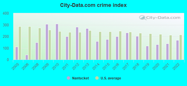
Type |
2009 |
2010 |
2011 |
2012 |
2013 |
2014 |
2015 |
2016 |
2017 |
2018 |
2019 |
2020 |
2021 |
2022 |
|---|---|---|---|---|---|---|---|---|---|---|---|---|---|---|
| Murders (per 100,000) | 1 (8.8) | 0 (0.0) | 0 (0.0) | 0 (0.0) | 0 (0.0) | 0 (0.0) | 0 (0.0) | 0 (0.0) | 0 (0.0) | 0 (0.0) | 0 (0.0) | 0 (0.0) | 0 (0.0) | 0 (0.0) |
| Rapes (per 100,000) | 3 (26.4) | 3 (29.5) | 1 (9.8) | 3 (29.3) | 8 (77.1) | 1 (9.5) | 3 (27.2) | 4 (36.2) | 7 (62.7) | 9 (79.0) | 2 (17.6) | 4 (34.8) | 4 (34.5) | 8 (54.0) |
| Robberies (per 100,000) | 1 (8.8) | 3 (29.5) | 3 (29.3) | 2 (19.5) | 3 (28.9) | 0 (0.0) | 0 (0.0) | 2 (18.1) | 0 (0.0) | 1 (8.8) | 0 (0.0) | 1 (8.7) | 0 (0.0) | 0 (0.0) |
| Assaults (per 100,000) | 53 (465.7) | 60 (589.9) | 20 (195.4) | 46 (449.6) | 30 (289.1) | 6 (57.2) | 30 (271.6) | 20 (181.2) | 40 (358.3) | 27 (237.1) | 25 (219.4) | 14 (121.9) | 20 (172.4) | 32 (216.0) |
| Burglaries (per 100,000) | 95 (834.8) | 46 (452.2) | 54 (527.7) | 51 (498.4) | 29 (279.4) | 61 (581.3) | 28 (253.5) | 51 (462.1) | 35 (313.5) | 21 (184.4) | 17 (149.2) | 9 (78.4) | 28 (241.4) | 35 (236.3) |
| Thefts (per 100,000) | 288 (2,531) | 296 (2,910) | 258 (2,521) | 301 (2,942) | 286 (2,756) | 228 (2,173) | 202 (1,829) | 249 (2,256) | 215 (1,926) | 193 (1,695) | 137 (1,202) | 198 (1,724) | 144 (1,241) | 197 (1,330) |
| Auto thefts (per 100,000) | 17 (149.4) | 13 (127.8) | 8 (78.2) | 13 (127.1) | 15 (144.5) | 13 (123.9) | 12 (108.7) | 9 (81.6) | 16 (143.3) | 11 (96.6) | 4 (35.1) | 3 (26.1) | 14 (120.7) | 21 (141.8) |
| Arson (per 100,000) | 0 (0.0) | 1 (9.8) | 2 (19.5) | 1 (9.8) | 0 (0.0) | 0 (0.0) | 0 (0.0) | 0 (0.0) | 5 (44.8) | 0 (0.0) | 1 (8.8) | 0 (0.0) | 0 (0.0) | 0 (0.0) |
| City-Data.com crime index | 306.1 | 308.7 | 199.7 | 282.0 | 269.5 | 156.6 | 175.7 | 199.8 | 232.2 | 201.7 | 119.3 | 131.4 | 138.3 | 167.5 |
The City-Data.com crime index weighs serious crimes and violent crimes more heavily. Higher means more crime, U.S. average is 246.1. It adjusts for the number of visitors and daily workers commuting into cities.
Crime rate in Nantucket detailed stats: murders, rapes, robberies, assaults, burglaries, thefts, arson
Full-time law enforcement employees in 2021, including police officers: 51 (34 officers - 28 male; 6 female).
| Officers per 1,000 residents here: | 2.93 |
| Massachusetts average: | 2.53 |
 Recent articles from our blog. Our writers, many of them Ph.D. graduates or candidates, create easy-to-read articles on a wide variety of topics.

 | New York and DC will soon have more flights to Martha's Vineyard and Nantucket (64 replies) |
| What is the great appeal of Nantucket? (99 replies) |
| Nantucket To Decide If Women Can Go Topless At Beaches Next Year (94 replies) |
| 2024 Real Estate Observations (799 replies) |
| 2023 Real Estate Observations (5278 replies) |
| MA is Snobby (321 replies) |
Latest news from Nantucket, MA collected exclusively by city-data.com from local newspapers, TV, and radio stations
Nantucket, MA City Guides:
Ancestries: Irish (15.3%), American (11.2%), English (10.7%), Italian (3.3%), German (3.0%), Polish (2.7%).
Current Local Time: EST time zone
Incorporated in 1671
Elevation: 30 feet
Land area: 2.46 square miles.
Population density: 3,025 people per square mile (average).
1,383 residents are foreign born (7.2% Europe, 3.6% Latin America, 1.7% Asia).
| This place: | 13.2% |
| Massachusetts: | 17.6% |
Median real estate property taxes paid for housing units with mortgages in 2022: $3,234 (0.3%)
Median real estate property taxes paid for housing units with no mortgage in 2022: $3,369 (0.3%)
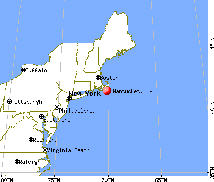
Nearest city with pop. 50,000+: New Bedford, MA  (50.2 miles , pop. 93,768).
Nearest city with pop. 200,000+: Boston, MA (88.2 miles , pop. 589,141).
Nearest city with pop. 1,000,000+: Queens, NY (198.1 miles , pop. 2,229,379).
Nearest cities:
), ), ), Latitude: 41.28 N, Longitude: 70.10 W
Daytime population change due to commuting: +1,733 (+16.5%)
Workers who live and work in this place: 5,614 (99.6%)
Area codes: 508, 774
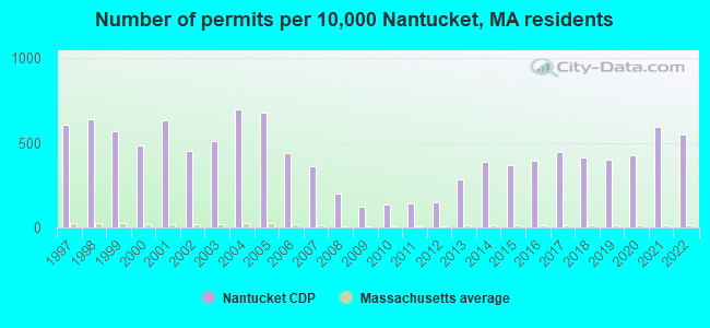
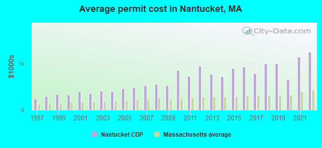
Single-family new house construction building permits:
- 2022: 209 buildings, average cost: $1,250,900
- 2021: 227 buildings, average cost: $1,144,500
- 2020: 162 buildings, average cost: $660,400
- 2019: 154 buildings, average cost: $993,900
- 2018: 157 buildings, average cost: $993,900
- 2017: 170 buildings, average cost: $782,400
- 2016: 150 buildings, average cost: $933,000
- 2015: 140 buildings, average cost: $896,400
- 2014: 149 buildings, average cost: $722,300
- 2013: 109 buildings, average cost: $770,200
- 2012: 58 buildings, average cost: $942,100
- 2011: 54 buildings, average cost: $731,900
- 2010: 53 buildings, average cost: $852,800
- 2009: 46 buildings, average cost: $530,200
- 2008: 76 buildings, average cost: $562,400
- 2007: 139 buildings, average cost: $534,300
- 2006: 168 buildings, average cost: $487,400
- 2005: 260 buildings, average cost: $466,800
- 2004: 267 buildings, average cost: $398,000
- 2003: 196 buildings, average cost: $412,900
- 2002: 173 buildings, average cost: $357,200
- 2001: 243 buildings, average cost: $401,100
- 2000: 185 buildings, average cost: $328,400
- 1999: 218 buildings, average cost: $335,500
- 1998: 244 buildings, average cost: $298,600
- 1997: 233 buildings, average cost: $242,200
| Here: | 3.5% |
| Massachusetts: | 3.5% |
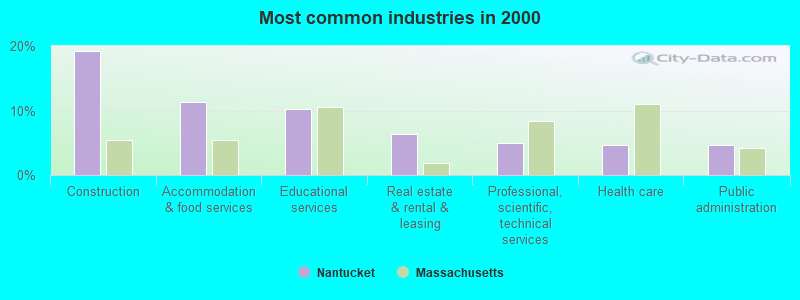
- Construction (19.2%)
- Accommodation & food services (11.3%)
- Educational services (10.3%)
- Real estate & rental & leasing (6.4%)
- Professional, scientific, technical services (5.0%)
- Health care (4.7%)
- Public administration (4.6%)
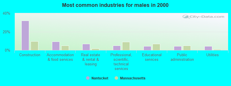
- Construction (32.0%)
- Accommodation & food services (9.3%)
- Real estate & rental & leasing (6.9%)
- Professional, scientific, technical services (4.9%)
- Educational services (4.5%)
- Public administration (4.4%)
- Utilities (4.3%)

- Educational services (16.8%)
- Accommodation & food services (13.5%)
- Health care (8.0%)
- Real estate & rental & leasing (5.9%)
- Professional, scientific, technical services (5.1%)
- Public administration (4.9%)
- Construction (4.9%)

- Other sales and related occupations, including supervisors (8.1%)
- Carpenters (7.3%)
- Other management occupations, except farmers and farm managers (6.3%)
- Building and grounds cleaning and maintenance occupations (5.0%)
- Preschool, kindergarten, elementary, and middle school teachers (4.6%)
- Retail sales workers, except cashiers (3.0%)
- Other office and administrative support workers, including supervisors (3.0%)
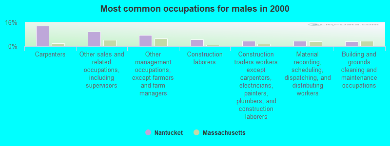
- Carpenters (13.8%)
- Other sales and related occupations, including supervisors (9.9%)
- Other management occupations, except farmers and farm managers (7.5%)
- Construction laborers (4.5%)
- Construction traders workers except carpenters, electricians, painters, plumbers, and construction laborers (3.6%)
- Material recording, scheduling, dispatching, and distributing workers (3.5%)
- Building and grounds cleaning and maintenance occupations (3.2%)

- Preschool, kindergarten, elementary, and middle school teachers (8.2%)
- Building and grounds cleaning and maintenance occupations (7.0%)
- Other sales and related occupations, including supervisors (6.1%)
- Other teachers, instructors, education, training, and library occupations (6.1%)
- Other office and administrative support workers, including supervisors (5.7%)
- Other management occupations, except farmers and farm managers (5.0%)
- Retail sales workers, except cashiers (4.5%)
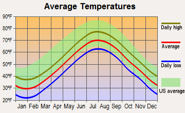
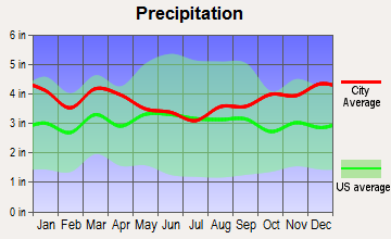
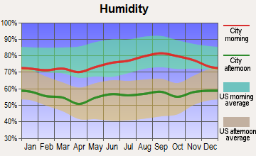
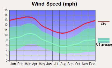
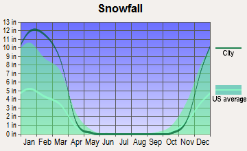
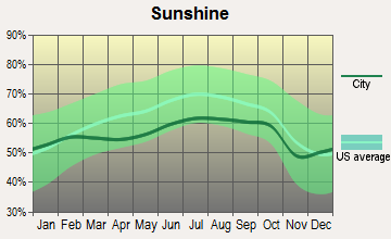
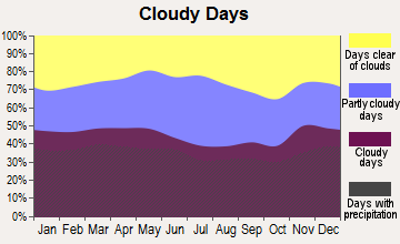
Average climate in Nantucket, Massachusetts
Based on data reported by over 4,000 weather stations
|
|

Earthquake activity:
Nantucket-area historical earthquake activity is significantly above Massachusetts state average. It is 79% smaller than the overall U.S. average.On 8/22/1992 at 12:20:32, a magnitude 4.8 (4.8 MB, 3.8 MS, 4.7 LG, Depth: 6.2 mi, Class: Light, Intensity: IV - V) earthquake occurred 150.9 miles away from Nantucket center
On 10/16/2012 at 23:12:25, a magnitude 4.7 (4.7 ML, Depth: 10.0 mi) earthquake occurred 162.7 miles away from Nantucket center
On 10/7/1983 at 10:18:46, a magnitude 5.3 (5.1 MB, 5.3 LG, 5.1 ML, Class: Moderate, Intensity: VI - VII) earthquake occurred 284.1 miles away from Nantucket center
On 1/19/1982 at 00:14:42, a magnitude 4.7 (4.5 MB, 4.7 MD, 4.5 LG) earthquake occurred 171.5 miles away from the city center
On 4/20/2002 at 10:50:47, a magnitude 5.3 (5.3 ML, Depth: 3.0 mi) earthquake occurred 288.3 miles away from the city center
On 4/20/2002 at 10:50:47, a magnitude 5.2 (5.2 MB, 4.2 MS, 5.2 MW, 5.0 MW) earthquake occurred 287.6 miles away from Nantucket center
Magnitude types: regional Lg-wave magnitude (LG), body-wave magnitude (MB), duration magnitude (MD), local magnitude (ML), surface-wave magnitude (MS), moment magnitude (MW)
Natural disasters:
The number of natural disasters in Nantucket County (17) is near the US average (15).Major Disasters (Presidential) Declared: 8
Emergencies Declared: 7
Causes of natural disasters: Hurricanes: 6, Floods: 4, Snowstorms: 3, Storms: 3, Winter Storms: 3, Blizzards: 2, Snows: 2, Snowfall: 1, Wind: 1, Other: 1 (Note: some incidents may be assigned to more than one category).

Hospitals and medical centers in Nantucket:
Airports and heliports located in Nantucket:
- Nantucket Memorial Airport (ACK) (Runways: 3, Commercial Ops: 828, Air Taxi Ops: 83,413, Itinerant Ops: 34,142, Local Ops: 178, Military Ops: 774)
- Waine Heliport (19MA)
Colleges/universities with over 2000 students nearest to Nantucket:
- Cape Cod Community College (about 31 miles; West Barnstable, MA; Full-time enrollment: 2,491)
- University of Massachusetts-Dartmouth (about 53 miles; North Dartmouth, MA; FT enrollment: 7,545)
- Bristol Community College (about 61 miles; Fall River, MA; FT enrollment: 5,707)
- Salve Regina University (about 64 miles; Newport, RI; FT enrollment: 2,349)
- Roger Williams University (about 66 miles; Bristol, RI; FT enrollment: 4,375)
- Bridgewater State University (about 67 miles; Bridgewater, MA; FT enrollment: 9,802)
- Massasoit Community College (about 72 miles; Brockton, MA; FT enrollment: 5,442)
Public high school in Nantucket:
- NANTUCKET HIGH (Students: 414, Location: 10 SURFSIDE ROAD, Grades: 9-12)
Public elementary/middle schools in Nantucket:
- NANTUCKET ELEMENTARY (Students: 617, Location: 30 SURFSIDE ROAD, Grades: PK-5)
- CYRUS PEIRCE (Students: 277, Location: 10 SURFSIDE ROAD, Grades: 6-8)
Private elementary/middle schools in Nantucket:
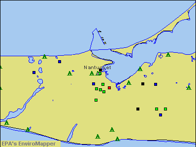
Points of interest:
Notable locations in Nantucket: Nantucket Harbor Range Light (A), Brant Point Light (B), Nantucket Ferry Slip Light (C), Loines Observatory (D), Brant Point Racquet Club (E), Commercial Wharf (F), Jetties Beach Public Tennis Courts (G), Nantucket Community-School Pool (H), Nantucket Shipyard (I), Nantucket Town Pier (J), Nantucket Yacht Club (K), Old Brant Point Lighthouse (L), Old North Wharf (M), Old South Wharf (N), Steamboat Wharf (O), Steamship Authority Ferry (P), Straight Wharf (Q), Thomas Macy Warehouse (R), Academy Hill Housing (S), Fair Street Museum (T). Display/hide their locations on the map
Churches in Nantucket include: Unitarian Universalist Church (A), Society of Friends Church (B), Saint Pauls Episcopal Church (C), Saint Marys Our Lady of the Isle Roman Catholic Church (D), Nantucket Worship Center (E), Nantucket United Methodist Church (F), Kingdom Hall of Jehovahs Witnesses (G), Friends Meeting House (H), First Congregational Church (I). Display/hide their locations on the map
Cemeteries: Old North Cemetery (1), Prospect Hill Cemetery (2), Saint Marys Cemetery (3), African Baptist Cemetery (4), Friends Burying Ground (5), New Town Cemetery (6), Old Town Cemetery (7). Display/hide their locations on the map
Lakes: Goose Pond (A), No Bottom Pond (B). Display/hide their locations on the map
Parks in Nantucket include: Soldier and Sailors Monument (1), Nantucket Historic District (2), Mill Hill Park (3), Main Street Square (4), Lily Pond Park (5), Greater Light Garden (6), Abiah Folger Franklin Fountain (7). Display/hide their locations on the map
Beaches: South Beach (A), Childrens Beach (B), Cliff Beach (C), Clean Shore (D). Display/hide their locations on the map
Tourist attractions: Egan Institute of Maritime Studies (Museums; 4 Winter Street), African Meetinghouse On Nantucket (Museums; 29 York Street), Coffin School (Museums; 4 Winter Street), Maria Mitchell Association - Administration Office (Cultural Attractions- Events- & Facilities; 2 Vestal Street), Nantucket Historical Association (Cultural Attractions- Events- & Facilities; 2 Whalers Lane), Maria Mitchell Association - Vestal Street Observatory (Cultural Attractions- Events- & Facilities; 3 Vestal Street), Mill Hill Press (Cultural Attractions- Events- & Facilities; 4 Winter Street), Nantucket Atheneum (Cultural Attractions- Events- & Facilities; 1 India Street), Nantucket Lightship Basket Museum Inc (49 Union Street).
Hotels: Brant Point Inn (6 South Beach Street), Le Languedoc Inn & Restaurant (24 Broad Street), Beachside at Nantucket (30 North Beach Street), Nesbitt Inn (21 Broad Street), Carlisle House Inn (26 North Water Street), Brass Lantern Inn (11 North Water Street), Manor House Inn Reservations Only (11 India Street), Breakers (50 Easton Street), Languedoc Restaurant & Inn 24 (16 Broad Street).
Court: Mass Commonwealth - Trial Courts- Juvenile Court Dept- Nantucket Juvenile C (16 Broad Street).
Birthplace of: Joseph Gardner Swift - Superintendent of the Military Academy, Charles Frederick Briggs - Humorist, Charles J. Folger - Politician, John Toner - Football player and coach, Maria Mitchell - Astronomer, Owen Chase - Sailor, Absalom Boston - Whalers, Douglas Harriman Kennedy - Television reporter, Lucretia Mott - (1793-1880), women's rights activist and abolitionist, Allison Mleczko - Ice hockey player.
Drinking water stations with addresses in Nantucket and their reported violations in the past:
WANNACOMET WATER COMPANY (Population served: 18,205, Groundwater):Past health violations:SIASCONSET WATER DEPARTMENT (Address: 1 MILESTONE ROAD , Population served: 3,000, Groundwater):Past monitoring violations:
- MCL, Monthly (TCR) - In SEP-2012, Contaminant: Coliform. Follow-up actions: St AO (w/o penalty) issued (NOV-30-2012), St Compliance achieved (NOV-30-2012)
- MCL, Monthly (TCR) - In SEP-2011, Contaminant: Coliform. Follow-up actions: St AO (w/o penalty) issued (NOV-29-2011), St Compliance achieved (NOV-29-2011)
- MCL, Monthly (TCR) - In MAR-2008, Contaminant: Coliform. Follow-up actions: St AO (w/o penalty) issued (MAY-28-2008), St Compliance achieved (MAY-27-2009)
- MCL, Monthly (TCR) - In AUG-2007, Contaminant: Coliform. Follow-up actions: St AO (w/o penalty) issued (DEC-06-2007), St Compliance achieved (DEC-06-2007)
- Follow-up Or Routine LCR Tap M/R - In OCT-01-2009, Contaminant: Lead and Copper Rule. Follow-up actions: St AO (w/o penalty) issued (NOV-18-2009), St Compliance achieved (OCT-10-2010)
- Follow-up Or Routine LCR Tap M/R - In OCT-01-2008, Contaminant: Lead and Copper Rule. Follow-up actions: St AO (w/o penalty) issued (OCT-21-2008), St Compliance achieved (OCT-10-2010)
- Monitoring, Repeat Major (TCR) - In AUG-2007, Contaminant: Coliform (TCR). Follow-up actions: St AO (w/o penalty) issued (DEC-06-2007), St Compliance achieved (DEC-06-2007)
- Notification, State - In AUG-2007, Contaminant: Coliform (TCR). Follow-up actions: St AO (w/o penalty) issued (DEC-06-2007), St Compliance achieved (DEC-06-2007)
- 3 minor monitoring violations
Past health violations:Past monitoring violations:
- MCL, Monthly (TCR) - In MAY-2013, Contaminant: Coliform. Follow-up actions: St AO (w/o penalty) issued (AUG-30-2013), St Compliance achieved (AUG-30-2013)
- MCL, Monthly (TCR) - In AUG-2010, Contaminant: Coliform. Follow-up actions: St AO (w/o penalty) issued (NOV-08-2010), St Compliance achieved (NOV-08-2010)
- MCL, Monthly (TCR) - In AUG-2009, Contaminant: Coliform. Follow-up actions: St AO (w/o penalty) issued (NOV-30-2009), St Compliance achieved (NOV-30-2009)
- MCL, Monthly (TCR) - In JUN-2007, Contaminant: Coliform. Follow-up actions: St AO (w/o penalty) issued (DEC-06-2007), St Compliance achieved (DEC-06-2007)
- One minor monitoring violation
- 39 regular monitoring violations
| This place: | 2.4 people |
| Massachusetts: | 2.5 people |
| This place: | 55.8% |
| Whole state: | 63.0% |
| This place: | 8.8% |
| Whole state: | 7.0% |
Likely homosexual households (counted as self-reported same-sex unmarried-partner households)
- Lesbian couples: 0.3% of all households
- Gay men: 0.6% of all households
People in group quarters in Nantucket in 2010:
- 35 people in nursing facilities/skilled-nursing facilities
- 13 people in workers' group living quarters and job corps centers
- 4 people in group homes intended for adults
12 people in other group homes in 2000
Banks with branches in Nantucket (2011 data):
- Sovereign Bank, National Association: Orange Street Branch, Amelia Drive Branch, Nantucket Bank Branch. Info updated 2012/01/31: Bank assets: $78,146.9 mil, Deposits: $48,042.9 mil, headquarters in Wilmington, DE, positive income, Commercial Lending Specialization, 718 total offices, Holding Company: Banco Santander, S.A.
- Bank of America, National Association: Pacific National - Main Street Branc at 61 Main Street, branch established on 1804/01/01; Pacific National-Sparks Branch at 15 Sparks Avenue, branch established on 1979/06/15. Info updated 2009/11/18: Bank assets: $1,451,969.3 mil, Deposits: $1,077,176.8 mil, headquarters in Charlotte, NC, positive income, 5782 total offices, Holding Company: Bank Of America Corporation
- The Cape Cod Five Cents Savings Bank: Main Street Nantucket Branch at Zero Main Street, branch established on 2012/01/17; Nantucket Branch at 6 West Creek Road, branch established on 2011/03/08. Info updated 2006/11/03: Bank assets: $2,106.5 mil, Deposits: $1,831.3 mil, headquarters in Harwich Port, MA, positive income, Mortgage Lending Specialization, 17 total offices
For population 15 years and over in Nantucket:
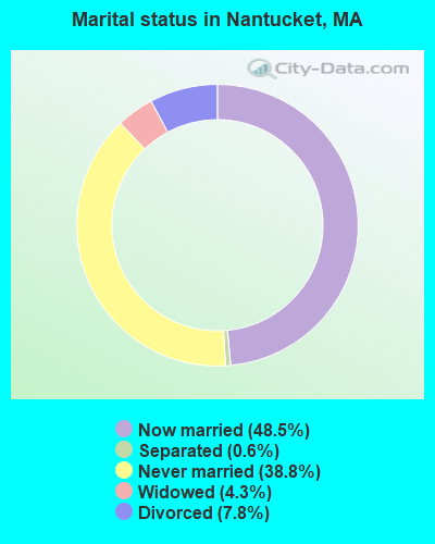
- Never married: 38.8%
- Now married: 48.5%
- Separated: 0.6%
- Widowed: 4.3%
- Divorced: 7.8%
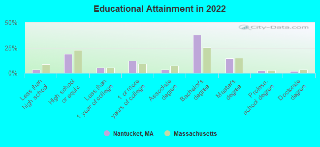
For population 25 years and over in Nantucket:
- High school or higher: 96.5%
- Bachelor's degree or higher: 55.8%
- Graduate or professional degree: 18.3%
- Unemployed: 6.5%
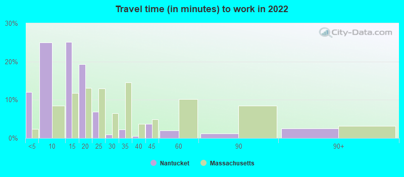
- Mean travel time to work (commute): 8.5 minutes
| Here: | 10.2 |
| Massachusetts average: | 13.0 |
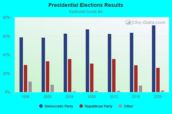
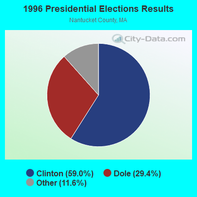
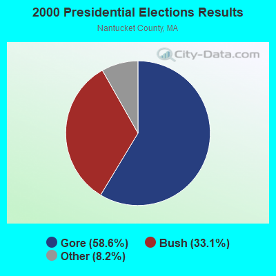
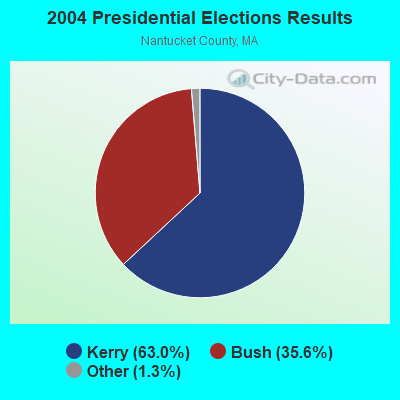
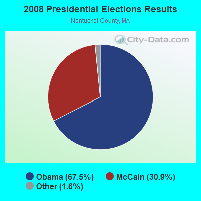
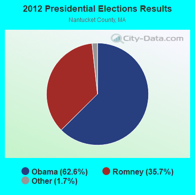

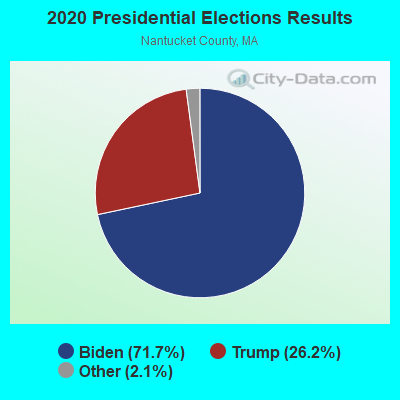
Graphs represent county-level data. Detailed 2008 Election Results
Religion statistics for Nantucket, MA (based on Nantucket County data)
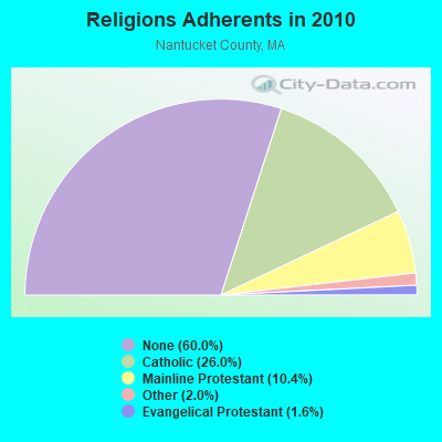
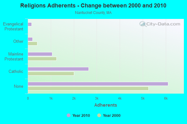
| Religion | Adherents | Congregations |
|---|---|---|
| Catholic | 2,642 | 1 |
| Mainline Protestant | 1,058 | 5 |
| Other | 207 | 2 |
| Evangelical Protestant | 158 | 2 |
| None | 6,107 | - |
Food Environment Statistics:
| Nantucket County: | 4.52 / 10,000 pop. |
| Massachusetts: | 1.98 / 10,000 pop. |
| Nantucket County: | 3.62 / 10,000 pop. |
| Massachusetts: | 2.22 / 10,000 pop. |
| Nantucket County: | 0.90 / 10,000 pop. |
| Massachusetts: | 1.77 / 10,000 pop. |
| Nantucket County: | 41.59 / 10,000 pop. |
| Massachusetts: | 8.76 / 10,000 pop. |
| Nantucket County: | 7.0% |
| State: | 8.1% |
| Nantucket County: | 19.9% |
| Massachusetts: | 22.5% |
| Nantucket County: | 16.2% |
| Massachusetts: | 16.5% |
Health and Nutrition:
| Nantucket: | 49.9% |
| Massachusetts: | 50.5% |
| Here: | 48.6% |
| State: | 48.0% |
| Nantucket: | 28.9 |
| Massachusetts: | 28.4 |
| Here: | 20.9% |
| State: | 20.7% |
| Nantucket: | 8.8% |
| State: | 10.4% |
| Nantucket: | 6.8 |
| Massachusetts: | 6.8 |
| Nantucket: | 33.5% |
| State: | 33.4% |
| Here: | 57.9% |
| Massachusetts: | 57.1% |
| Nantucket: | 80.5% |
| Massachusetts: | 79.2% |
More about Health and Nutrition of Nantucket, MA Residents
| Businesses in Nantucket, MA | ||||
| Name | Count | Name | Count | |
|---|---|---|---|---|
| Decora Cabinetry | 2 | New Balance | 1 | |
| FedEx | 4 | Nike | 1 | |
| Ford | 1 | RadioShack | 1 | |
| H&R Block | 1 | Stop & Shop | 2 | |
| MasterBrand Cabinets | 4 | UPS | 3 | |
Strongest AM radio stations in Nantucket:
- WBZ (1030 AM; 50 kW; BOSTON, MA; Owner: INFINITY BROADCASTING OPERATIONS, INC.)
- WEEI (850 AM; 50 kW; BOSTON, MA; Owner: ENTERCOM BOSTON LICENSE, LLC)
- WRKO (680 AM; 50 kW; BOSTON, MA; Owner: ENTERCOM BOSTON LICENSE, LLC)
- WALE (990 AM; 50 kW; GREENVILLE, RI; Owner: NORTH AMERICAN BROADCASTING CO., INC.)
- WKOX (1200 AM; 50 kW; FRAMINGHAM, MA; Owner: CAPSTAR TX LIMITED PARTNERSHIP)
- WCRN (830 AM; 50 kW; WORCESTER, MA; Owner: CARTER BROADCASTING CORPORATION)
- WBIX (1060 AM; 40 kW; NATICK, MA; Owner: LANGER BROADCASTING CORPORATION)
- WWZN (1510 AM; 50 kW; BOSTON, MA; Owner: ROSE CITY RADIO CORPORATION)
- WNNZ (640 AM; 50 kW; WESTFIELD, MA; Owner: CLEAR CHANNEL BROADCASTING LICENSES, INC.)
- WAMG (890 AM; 25 kW; DEDHAM, MA; Owner: MEGA COMMUNICATIONS OF DEDHAM LICENSEE, LLC)
- WTIC (1080 AM; 50 kW; HARTFORD, CT; Owner: INFINITY RADIO OPERATIONS INC.)
- WVNE (760 AM; daytime; 25 kW; LEICESTER, MA; Owner: BLOUNT MASSCOM, INC.)
- WRCA (1330 AM; 25 kW; WALTHAM, MA; Owner: WRCA LICENSE, LLC)
Strongest FM radio stations in Nantucket:
- WNAN (91.1 FM; NANTUCKET, MA; Owner: WGBH EDUCATIONAL FOUNDATION, INC.)
- WRZE (96.3 FM; NANTUCKET, MA; Owner: QANTUM OF CAPE COD LICENSE COMPANY, LLC)
- WNCK (89.5 FM; NANTUCKET, MA; Owner: NANTUCKET PUBLIC RADIO INC)
- WXTK (95.1 FM; WEST YARMOUTH, MA; Owner: BOCH BROADCASTING LTD. PARTNERSHIP)
FCC Registered Antenna Towers: 76 (See the full list of FCC Registered Antenna Towers)
FCC Registered Private Land Mobile Towers: 1 (See the full list of FCC Registered Private Land Mobile Towers in Nantucket, MA)
FCC Registered Broadcast Land Mobile Towers: 21 (See the full list of FCC Registered Broadcast Land Mobile Towers)
FCC Registered Microwave Towers: 13 (See the full list of FCC Registered Microwave Towers in this town)
FCC Registered Paging Towers: 1 (See the full list of FCC Registered Paging Towers)
FCC Registered Maritime Coast & Aviation Ground Towers: 21 (See the full list of FCC Registered Maritime Coast & Aviation Ground Towers)
FCC Registered Amateur Radio Licenses: 67 (See the full list of FCC Registered Amateur Radio Licenses in Nantucket)
FAA Registered Aircraft Manufacturers and Dealers: 4 (See the full list of FAA Registered Manufacturers and Dealers in Nantucket)
FAA Registered Aircraft: 69 (See the full list of FAA Registered Aircraft)
2002 - 2018 National Fire Incident Reporting System (NFIRS) incidents
- Fire incident types reported to NFIRS in Nantucket, MA
- 57459.1%Structure Fires
- 18519.1%Outside Fires
- 11611.9%Mobile Property/Vehicle Fires
- 969.9%Other
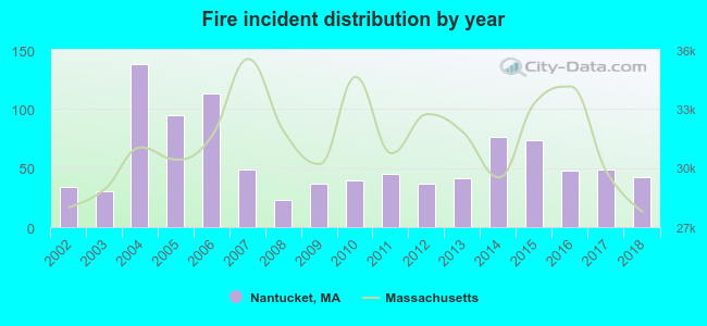 Based on the data from the years 2002 - 2018 the average number of fire incidents per year is 57. The highest number of fire incidents - 138 took place in 2004, and the least - 23 in 2008. The data has a growing trend.
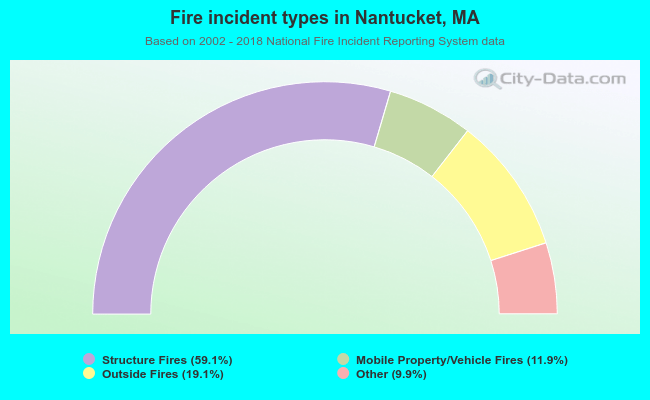 When looking into fire subcategories, the most incidents belonged to: Structure Fires (59.1%), and Outside Fires (19.1%).
| Most common first names in Nantucket, MA among deceased individuals | ||
| Name | Count | Lived (average) |
|---|---|---|
| Mary | 82 | 80.3 years |
| John | 64 | 75.3 years |
| Robert | 48 | 73.3 years |
| William | 43 | 74.5 years |
| Margaret | 37 | 79.4 years |
| Elizabeth | 32 | 82.5 years |
| Charles | 32 | 72.3 years |
| James | 32 | 76.7 years |
| Helen | 31 | 83.7 years |
| Joseph | 26 | 83.4 years |
| Most common last names in Nantucket, MA among deceased individuals | ||
| Last name | Count | Lived (average) |
|---|---|---|
| Sylvia | 23 | 82.6 years |
| Coffin | 19 | 80.7 years |
| Williams | 17 | 82.8 years |
| Perry | 12 | 78.6 years |
| Gardner | 12 | 83.4 years |
| Chase | 12 | 82.1 years |
| Allen | 11 | 80.4 years |
| Smith | 11 | 81.5 years |
| Davis | 11 | 73.6 years |
| King | 10 | 81.8 years |
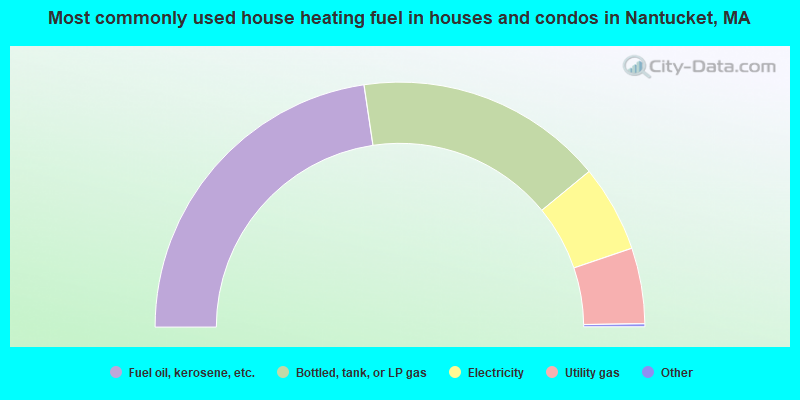
- 45.3%Fuel oil, kerosene, etc.
- 32.8%Bottled, tank, or LP gas
- 11.5%Electricity
- 10.0%Utility gas
- 0.2%No fuel used
- 0.1%Solar energy
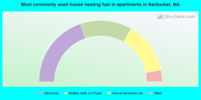
- 39.5%Electricity
- 27.3%Bottled, tank, or LP gas
- 27.2%Fuel oil, kerosene, etc.
- 2.8%No fuel used
- 1.2%Utility gas
- 1.2%Other fuel
- 0.7%Wood
Nantucket compared to Massachusetts state average:
- Median house value significantly above state average.
- Unemployed percentage below state average.
- Black race population percentage significantly above state average.
- Hispanic race population percentage significantly above state average.
- Foreign-born population percentage above state average.
- Length of stay since moving in significantly above state average.
- House age below state average.
- Number of college students above state average.
- Percentage of population with a bachelor's degree or higher above state average.
Nantucket on our top lists:
- #5 on the list of "Top 101 cities with the largest percentage of people in other workers' dormitories (population 1,000+)"
- #11 on the list of "Top 101 cities with largest percentage of males in occupations: construction and extraction occupations (population 5,000+)"
- #12 on the list of "Top 101 cities with largest percentage of males in industries: construction (population 5,000+)"
- #15 on the list of "Top 101 cities with the most residents born in Ireland (population 500+)"
- #33 on the list of "Top 101 cities with the most residents born in Costa Rica (population 500+)"
- #38 on the list of "Top 101 cities with the highest cost per building permit(population 5,000+)"
- #43 on the list of "Top 101 cities with the most residents born in Jamaica (population 500+)"
- #55 on the list of "Top 101 cities with the most people taking a bicycle to work (population 5,000+)"
- #56 on the list of "Top 101 cities with the most people taking a ferryboat to work (population 5,000+)"
- #59 on the list of "Top 100 cities with highest ratio of median house value to median household income (pop. 5,000+)"
- #96 on the list of "Top 100 cities with highest median house value (pop. 5,000+)"
- #98 on the list of "Top 100 cities with shortest commuting times"
- #8 (02554) on the list of "Top 101 zip codes with the most museums in 2005"
- #58 (02554) on the list of "Top 101 zip codes with the largest percentage of taxpayers reporting profit/loss from business in 2012 (pop 5,000+)"
- #58 on the list of "Top 101 counties with the largest number of children under 18 without health insurance coverage in 2000"
- #68 on the list of "Top 101 counties with the highest percentage of residents relocating from foreign countries between 2010 and 2011"
- #68 on the list of "Top 101 counties with the largest number of people without health insurance coverage in 2000"
- #75 on the list of "Top 101 counties with the highest percentage of residents relocating to foreign countries in 2011"

|
|
Total of 19 patent applications in 2008-2024.