Newtown district, Virginia
Submit your own pictures of this city and show them to the world
- OSM Map
- General Map
- Google Map
- MSN Map

| Males: 706 | |
| Females: 703 |
| Median resident age: | 39.4 years |
| Virginia median age: | 35.7 years |
Zip code: 23148
| Newtown district: | $60,896 |
| VA: | $85,873 |
Estimated per capita income in 2022: $32,870 (it was $14,566 in 2000)
Newtown district income, earnings, and wages data
Estimated median house or condo value in 2022: $193,835 (it was $69,500 in 2000)
| Newtown district: | $193,835 |
| VA: | $365,700 |
Mean prices in 2022: all housing units: $281,634; detached houses: $300,179; mobile homes: $164,798
Newtown district, VA residents, houses, and apartments details
Detailed information about poverty and poor residents in Newtown district, VA


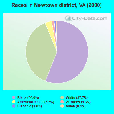
- 76256.0%Black alone
- 51337.7%White alone
- 483.5%American Indian alone
- 181.3%Two or more races
- 131.0%Hispanic
- 60.4%Asian alone
Races in Newtown district detailed stats: ancestries, foreign born residents, place of birth
 Recent articles from our blog. Our writers, many of them Ph.D. graduates or candidates, create easy-to-read articles on a wide variety of topics.
Current Local Time: EST time zone
Land area: 62.4 square miles.
Population density: 23 people per square mile (very low).

| Newtown district: | 0.6% ($422) |
| Virginia: | 1.0% ($1,143) |
Nearest city with pop. 50,000+: Richmond, VA  (32.7 miles , pop. 197,790).
Nearest city with pop. 200,000+: Washington, DC (69.6 miles , pop. 572,059).
Nearest city with pop. 1,000,000+: Philadelphia, PA (178.4 miles , pop. 1,517,550).
Nearest cities:
), ), ), ), )Latitude: 37.91 N, Longitude: 77.09 W
Area code commonly used in this area: 804

| Here: | 2.8% |
| Virginia: | 2.7% |
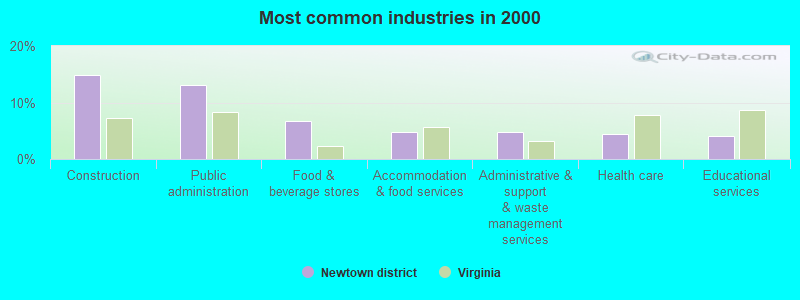
- Construction (14.8%)
- Public administration (13.1%)
- Food & beverage stores (6.7%)
- Accommodation & food services (4.7%)
- Administrative & support & waste management services (4.7%)
- Health care (4.4%)
- Educational services (4.1%)
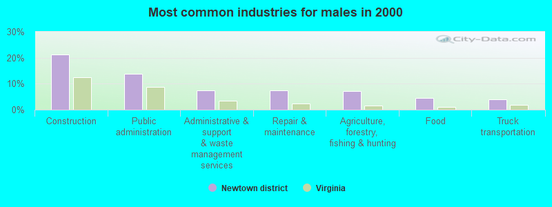
- Construction (21.3%)
- Public administration (13.8%)
- Administrative & support & waste management services (7.5%)
- Repair & maintenance (7.5%)
- Agriculture, forestry, fishing & hunting (7.2%)
- Food (4.5%)
- Truck transportation (3.9%)
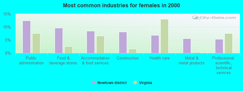
- Public administration (12.5%)
- Food & beverage stores (9.7%)
- Accommodation & food services (8.4%)
- Construction (8.1%)
- Health care (6.9%)
- Metal & metal products (5.6%)
- Professional, scientific, technical services (5.3%)
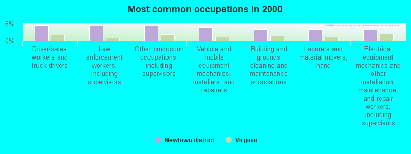
- Driver/sales workers and truck drivers (5.5%)
- Law enforcement workers, including supervisors (5.4%)
- Other production occupations, including supervisors (5.2%)
- Vehicle and mobile equipment mechanics, installers, and repairers (4.7%)
- Building and grounds cleaning and maintenance occupations (4.0%)
- Laborers and material movers, hand (4.0%)
- Electrical equipment mechanics and other installation, maintenance, and repair workers, including supervisors (3.8%)
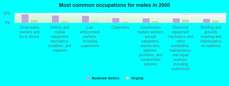
- Driver/sales workers and truck drivers (10.8%)
- Vehicle and mobile equipment mechanics, installers, and repairers (9.3%)
- Law enforcement workers, including supervisors (9.0%)
- Carpenters (6.3%)
- Construction traders workers except carpenters, electricians, painters, plumbers, and construction laborers (6.0%)
- Electrical equipment mechanics and other installation, maintenance, and repair workers, including supervisors (5.7%)
- Building and grounds cleaning and maintenance occupations (5.1%)
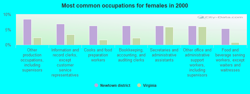
- Other production occupations, including supervisors (8.4%)
- Information and record clerks, except customer service representatives (6.9%)
- Cooks and food preparation workers (6.2%)
- Bookkeeping, accounting, and auditing clerks (6.2%)
- Secretaries and administrative assistants (6.2%)
- Other office and administrative support workers, including supervisors (6.2%)
- Food and beverage serving workers, except waiters and waitresses (5.3%)
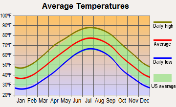
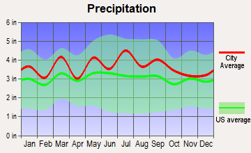
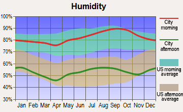
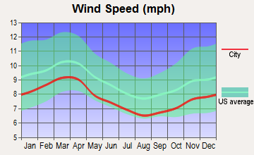
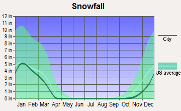
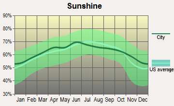
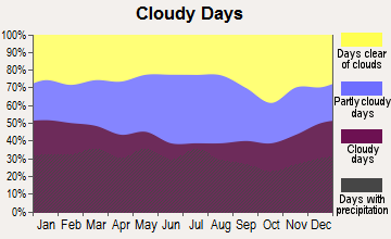
Average climate in Newtown district, Virginia
Based on data reported by over 4,000 weather stations
Tornado activity:
Newtown district-area historical tornado activity is slightly above Virginia state average. It is 8% smaller than the overall U.S. average.
On 10/18/1990, a category F3 (max. wind speeds 158-206 mph) tornado 16.7 miles away from the Newtown district city center killed one person and caused between $500,000 and $5,000,000 in damages.
On 11/2/1966, a category F3 tornado 19.1 miles away from the city center injured 2 people and caused between $5000 and $50,000 in damages.
Earthquake activity:
Newtown district-area historical earthquake activity is significantly above Virginia state average. It is 56% smaller than the overall U.S. average.On 8/23/2011 at 17:51:04, a magnitude 5.8 (5.8 MW, Depth: 3.7 mi, Class: Moderate, Intensity: VI - VII) earthquake occurred 46.1 miles away from the city center
On 8/25/2011 at 05:07:52, a magnitude 4.5 (4.5 ML, Depth: 4.2 mi, Class: Light, Intensity: IV - V) earthquake occurred 47.9 miles away from Newtown district center
On 12/9/2003 at 20:59:14, a magnitude 4.5 (4.5 MB, 4.5 LG) earthquake occurred 49.7 miles away from Newtown district center
On 12/9/2003 at 20:59:18, a magnitude 4.5 (4.5 ML, Depth: 6.2 mi) earthquake occurred 55.9 miles away from the city center
On 8/24/2011 at 00:04:36, a magnitude 4.2 (4.2 ML) earthquake occurred 47.1 miles away from the city center
On 8/9/2020 at 12:07:37, a magnitude 5.1 (5.1 MW, Depth: 4.7 mi) earthquake occurred 241.8 miles away from Newtown district center
Magnitude types: regional Lg-wave magnitude (LG), body-wave magnitude (MB), local magnitude (ML), moment magnitude (MW)
Natural disasters:
The number of natural disasters in King and Queen County (3) is a lot smaller than the US average (15).Major Disasters (Presidential) Declared: 1
Causes of natural disasters: Hurricane: 1, Tropical Storm: 1, Other: 1 (Note: some incidents may be assigned to more than one category).
Hospitals and medical centers near Newtown district:
Colleges/universities with over 2000 students nearest to Newtown district:
- J Sargeant Reynolds Community College (about 29 miles; Richmond, VA; Full-time enrollment: 8,271)
- Virginia Union University (about 32 miles; Richmond, VA; FT enrollment: 2,028)
- Virginia Commonwealth University (about 32 miles; Richmond, VA; FT enrollment: 26,647)
- University of Richmond (about 34 miles; University of Richmond, VA; FT enrollment: 3,745)
- University of Mary Washington (about 35 miles; Fredericksburg, VA; FT enrollment: 4,506)
- John Tyler Community College (about 43 miles; Chester, VA; FT enrollment: 5,864)
- College of Southern Maryland (about 46 miles; La Plata, MD; FT enrollment: 5,775)
Points of interest:
Notable locations in Newtown district: Garnett Mill (A), Upper King and Queen Rescue Squad (B), Upper King and Queen Volunteer Fire Department (C), Upper King and Queen Rescue Squad (D). Display/hide their locations on the map
Churches in Newtown district include: Rappahannock Indian Church (A), Upper King and Queen Church (B), Mount Olive Church (C). Display/hide their locations on the map
Reservoirs: Byrds Millpond (A), Garnett Millpond (B). Display/hide their locations on the map
Streams, rivers, and creeks: Root Swamp (A), Rickenaw Creek (B), Cook Swamp (C), Boiler Run (D), Beaver Branch (E). Display/hide their locations on the map
Park in Newtown district: Newtown Historic District (1). Display/hide its location on the map
| This city: | 2.6 people |
| Virginia: | 2.5 people |
| This city: | 72.5% |
| Whole state: | 67.0% |
| This city: | 6.0% |
| Whole state: | 5.7% |
Likely homosexual households (counted as self-reported same-sex unmarried-partner households)
- Lesbian couples: 0.5% of all households
- Gay men: 0.4% of all households
| This city: | 16.4% |
| Whole state: | 9.6% |
| This city: | 3.7% |
| Whole state: | 4.3% |
For population 15 years and over in Newtown district:
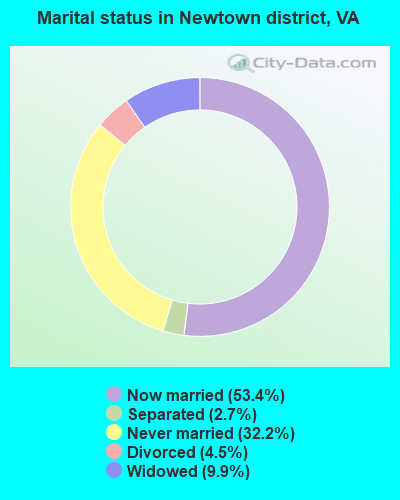
- Never married: 32.2%
- Now married: 53.4%
- Separated: 2.7%
- Widowed: 9.9%
- Divorced: 4.5%
For population 25 years and over in Newtown district:
- High school or higher: 62.4%
- Bachelor's degree or higher: 6.7%
- Graduate or professional degree: 3.8%
- Unemployed: 1.8%
- Mean travel time to work (commute): 39.3 minutes

| Here: | 14.8 |
| Virginia average: | 13.4 |
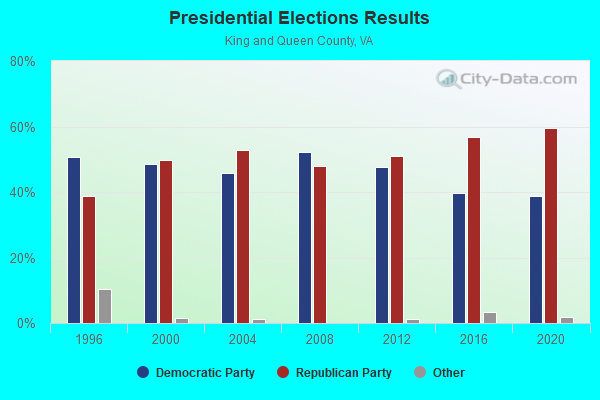
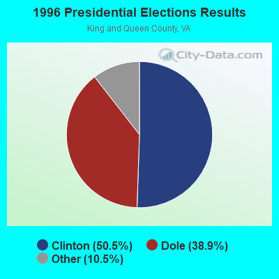
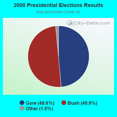
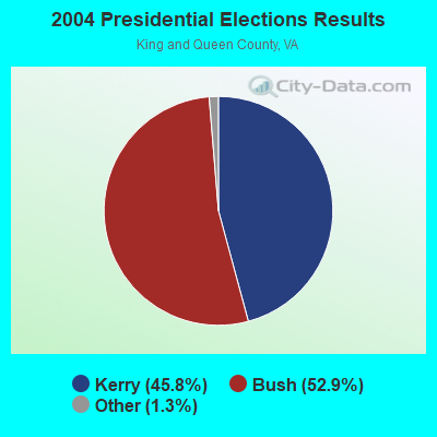
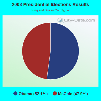
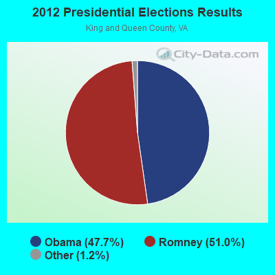
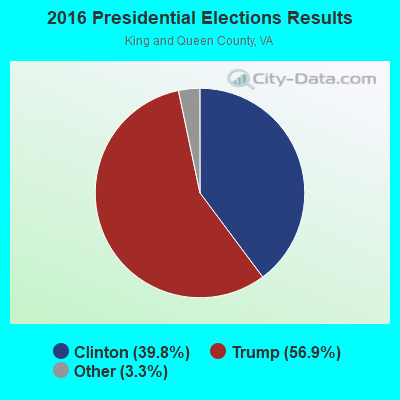
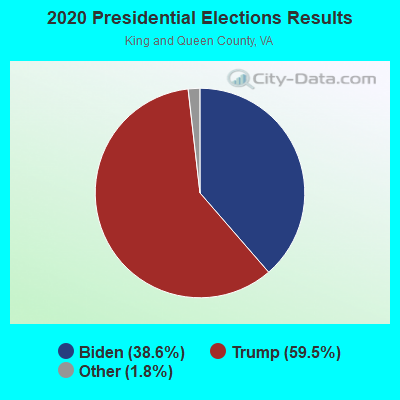
Graphs represent county-level data. Detailed 2008 Election Results
Religion statistics for Newtown district, VA (based on King and Queen County data)
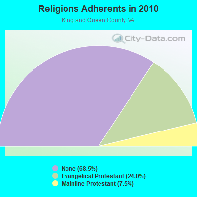
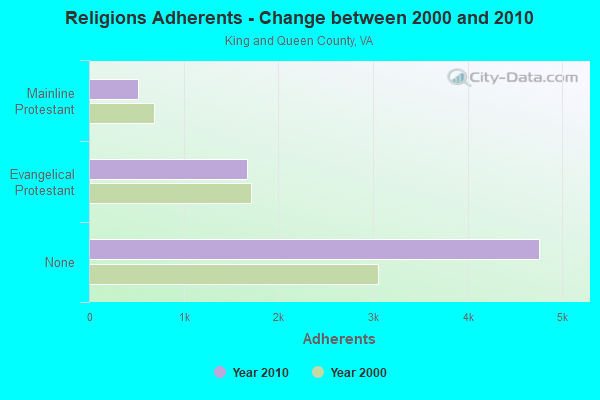
| Religion | Adherents | Congregations |
|---|---|---|
| Evangelical Protestant | 1,667 | 10 |
| Mainline Protestant | 518 | 6 |
| Other | 1 | 1 |
| None | 4,759 | - |
Food Environment Statistics:
| This county: | 1.46 / 10,000 pop. |
| Virginia: | 1.43 / 10,000 pop. |
| King and Queen County: | 5.83 / 10,000 pop. |
| State: | 4.03 / 10,000 pop. |
| Here: | 1.46 / 10,000 pop. |
| Virginia: | 7.65 / 10,000 pop. |
| Here: | 11.8% |
| State: | 9.3% |
| King and Queen County: | 29.9% |
| Virginia: | 26.7% |
| King and Queen County: | 20.5% |
| Virginia: | 18.6% |
Strongest AM radio stations in Newtown district:
- WRVA (1140 AM; 50 kW; RICHMOND, VA; Owner: CLEAR CHANNEL BROADCASTING LICENSES, INC.)
- WWGB (1030 AM; daytime; 50 kW; INDIAN HEAD, MD; Owner: GOOD BODY MEDIA, LLC)
- WTAR (850 AM; 50 kW; NORFOLK, VA; Owner: SINCLAIR COMMUNICATIONS)
- WRJR (670 AM; 20 kW; CLAREMONT, VA; Owner: CHESAPEAKE-PORTSMOUTH BROADCASTING CORPORATION)
- WTEM (980 AM; 50 kW; WASHINGTON, DC; Owner: AMFM RADIO LICENSES, L.L.C.)
- WREJ (1540 AM; 10 kW; RICHMOND, VA)
- WDZY (1290 AM; 25 kW; COLONIAL HEIGHTS, VA; Owner: ABC, INC.)
- WCKO (1110 AM; daytime; 50 kW; NORFOLK, VA; Owner: WORD BROADCASTING NETWORK, INC.)
- WKCW (1420 AM; 50 kW; WARRENTON, VA; Owner: WAY BROADCASTING, INC.)
- WPGC (1580 AM; 50 kW; MORNINGSIDE, MD; Owner: INFINITY WPGC(AM), INC.)
- WGGM (820 AM; 10 kW; CHESTER, VA; Owner: HOFFMAN COMMUNICATIONS, INC.)
- WBIS (1190 AM; 50 kW; ANNAPOLIS, MD; Owner: NATIONS RADIO, LLC)
- WCBM (680 AM; 50 kW; BALTIMORE, MD; Owner: WCBM MARYLAND, INC.)
Strongest FM radio stations in Newtown district:
- WWUZ (96.9 FM; BOWLING GREEN, VA; Owner: THE FREE LANCE-STAR PUBLISHING CO. OF FREDERICKSBURG, VA)
- WRAR-FM (105.5 FM; TAPPAHANNOCK, VA; Owner: RAPPAHANNOCK COMMUNICATIONS, INC.)
- WCVE-FM (88.9 FM; RICHMOND, VA; Owner: COMMONWEALTH PUBLIC BROADCASTING CORPORATION)
- WBTJ (106.5 FM; RICHMOND, VA; Owner: CAPSTAR TX LIMITED PARTNERSHIP)
- WCDX (92.1 FM; MECHANICSVILLE, VA; Owner: RADIO ONE LICENSES, LLC)
- WGRQ (95.9 FM; COLONIAL BEACH, VA; Owner: TELEMEDIA BROADCASTING, INC.)
- WNNT-FM (100.9 FM; WARSAW, VA; Owner: NORTHERN NECK & TIDEWATER COMMUNICATIONS, INC)
- WMXB (103.7 FM; RICHMOND, VA; Owner: COX RADIO, INC.)
- WRXL (102.1 FM; RICHMOND, VA; Owner: CLEAR CHANNEL BROADCASTING LICENSES, INC.)
- WJYJ (90.5 FM; FREDERICKSBURG, VA; Owner: CSN INTERNATIONAL)
- WYFJ (100.1 FM; ASHLAND, VA; Owner: BIBLE BROADCASTING NETWORK, INC.)
TV broadcast stations around Newtown district:
- WUPV (Channel 65; ASHLAND, VA; Owner: BELL BROADCASTING, L.L.C.)
- WCVE-TV (Channel 23; RICHMOND, VA; Owner: COMMONWEALTH PUBLIC BROADCASTING CORPORATION)
- WRLH-TV (Channel 35; RICHMOND, VA; Owner: WRLH LICENSEE, LLC)
- WXOB-LP (Channel 17; RICHMOND, VA; Owner: KM BROADCASTING, INC.)
- WTVR-TV (Channel 6; RICHMOND, VA; Owner: ELCOM OF VIRGINIA, INC.)
- WCVW (Channel 57; RICHMOND, VA; Owner: COMMONWEALTH PUBLIC BROADCASTING CORPORATION)
- WRIC-TV (Channel 8; PETERSBURG, VA; Owner: YOUNG BROADCASTING OF RICHMOND, INC.)
- WWBT (Channel 12; RICHMOND, VA; Owner: JEFFERSON-PILOT COMMUNICATIONS COMPANY OF VIRGINIA)
- W48BI (Channel 48; RICHMOND, VA; Owner: WORD OF GOD FELLOWSHIP, INC.)
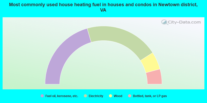
- 41.0%Fuel oil, kerosene, etc.
- 40.8%Electricity
- 9.8%Wood
- 8.4%Bottled, tank, or LP gas
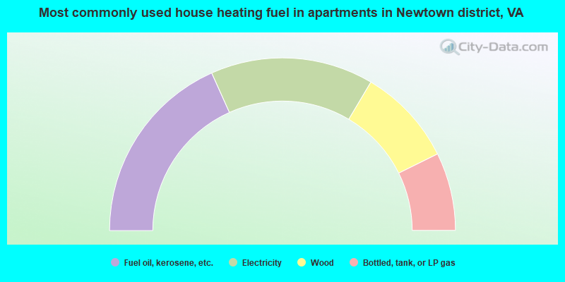
- 36.6%Fuel oil, kerosene, etc.
- 30.5%Electricity
- 18.3%Wood
- 14.6%Bottled, tank, or LP gas
Newtown district compared to Virginia state average:
- Median house value below state average.
- Unemployed percentage significantly below state average.
- Black race population percentage significantly above state average.
- Hispanic race population percentage significantly below state average.
- Median age above state average.
- Foreign-born population percentage significantly below state average.
- Renting percentage below state average.
- Length of stay since moving in significantly above state average.
- Number of rooms per house significantly below state average.
- House age significantly below state average.
- Number of college students below state average.
- Percentage of population with a bachelor's degree or higher significantly below state average.