Swansea, Massachusetts
Submit your own pictures of this town and show them to the world
- OSM Map
- General Map
- Google Map
- MSN Map
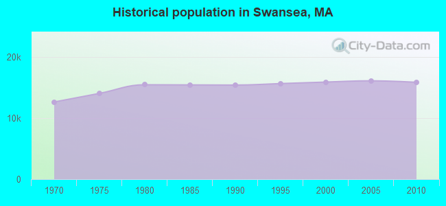
Population change since 2000: -0.2%
 |
| Males: 7,769 | |
| Females: 8,096 |
| Median resident age: | 44.3 years |
| Massachusetts median age: | 39.2 years |
Zip codes: 02777.
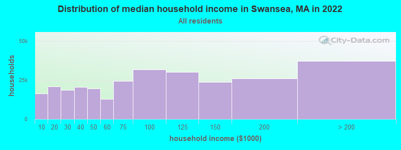
| Swansea: | $98,478 |
| MA: | $94,488 |
Estimated per capita income in 2022: $44,403 (it was $21,776 in 2000)
Swansea town income, earnings, and wages data
Estimated median house or condo value in 2022: $412,617 (it was $140,500 in 2000)
| Swansea: | $412,617 |
| MA: | $534,700 |
Mean prices in 2022: all housing units: $449,660; detached houses: $484,124; townhouses or other attached units: $382,766; in 2-unit structures: $322,469; in 3-to-4-unit structures: $355,875; in 5-or-more-unit structures: $269,714; mobile homes: $156,871; occupied boats, rvs, vans, etc.: $49,834
Detailed information about poverty and poor residents in Swansea, MA


Compare current foreclosures near Swansea, MA:
| Photo | Address | Area | Beds / Baths | Price | Details |
|---|---|---|---|---|---|

|
#1
Bushee Rd
Swansea, MA 02777
|
1,920 sq. feet
|
1 baths 3 beds |
show details | |

|
#2
Walter Ln
Swansea, MA 02777
|
1,088 sq. feet
|
1 baths 3 beds |
show details | |

|
#3
Calef Ave
Swansea, MA 02777
|
2,016 sq. feet
|
2 baths 3 beds |
show details | |

|
#4
Jette St
Swansea, MA 02777
|
1,270 sq. feet
|
1 baths 5 beds |
show details | |

|
#5
Dellawanda Rd
Swansea, MA 02777
|
1,052 sq. feet
|
1 baths 2 beds |
show details | |

|
#6
Veranda Ave
Swansea, MA 02777
|
1,271 sq. feet
|
1 baths 3 beds |
show details | |

|
#7
Kispert Ct
Swansea, MA 02777
|
1,344 sq. feet
|
1 baths 3 beds |
show details | |

|
#8
Burnside Dr
Swansea, MA 02777
|
1,508 sq. feet
|
1 baths 3 beds |
show details | |

|
#9
Calef Ave
Swansea, MA 02777
|
1,532 sq. feet
|
1 baths 3 beds |
show details | |

|
#10
Pinehurst Ave # 3
Swansea, MA 02777
|
1,378 sq. feet
|
1 baths 1 beds |
show details |
| Photo | Address | Area | Beds / Baths | Price | Details |
|---|---|---|---|---|---|

|
#11
Calef Ave
Swansea, MA 02777
|
2,414 sq. feet
|
2 baths 5 beds |
show details | |

|
#12
Puffer Ave
Swansea, MA 02777
|
1,296 sq. feet
|
1 baths 3 beds |
show details | |

|
#13
Norwood St
Swansea, MA 02777
|
892 sq. feet
|
1 baths 3 beds |
show details | |

|
#14
Mount Fair Cir
Swansea, MA 02777
|
1,980 sq. feet
|
2 baths 3 beds |
show details | |

|
#15
Bryants Way
Swansea, MA 02777
|
3,357 sq. feet
|
2 baths 5 beds |
show details | |

|
#16
Wilder St
Swansea, MA 02777
|
1,054 sq. feet
|
1 baths 2 beds |
show details | |

|
#17
Missile Loop
Swansea, MA 02777
|
1,176 sq. feet
|
1 baths 3 beds |
show details | |

|
#18
Whalon Ave
Swansea, MA 02777
|
1,734 sq. feet
|
1 baths 4 beds |
show details | |

|
#19
Hortonville Rd
Swansea, MA 02777
|
1,889 sq. feet
|
2 baths 2 beds |
show details | |

|
#20
Maple Ave
Swansea, MA 02777
|
1,455 sq. feet
|
1 baths 3 beds |
show details |
| Photo | Address | Area | Beds / Baths | Price | Details |
|---|---|---|---|---|---|

|
#21
Milford Rd # 2
Swansea, MA 02777
|
1,600 sq. feet
|
2 baths 4 beds |
show details | |

|
#22
Vinnicum Rd
Swansea, MA 02777
|
1,867 sq. feet
|
1 baths 2 beds |
show details | |

|
#23
Baker Rd
Swansea, MA 02777
|
- sq. feet
|
- baths - beds |
show details | |

|
#24
Gardners Neck Rd
Swansea, MA 02777
|
- sq. feet
|
- baths - beds |
show details | |

|
#25
Market St
Swansea, MA 02777
|
- sq. feet
|
- baths - beds |
show details | |

|
#26
Nottingham Cir
Swansea, MA 02777
|
- sq. feet
|
- baths - beds |
show details | |

|
#27
Hebron Ave
Attleboro, MA 02703
|
2,939 sq. feet
|
4 baths 6 beds |
$559,900
|
show details |

|
#28
Somerset Ave
Taunton, MA 02780
|
3,196 sq. feet
|
3 baths 4 beds |
$754,900
|
show details |

|
#29
Loomis St
North Attleboro, MA 02760
|
2,294 sq. feet
|
2 baths 4 beds |
$700,000
|
show details |

|
#30
County St
East Taunton, MA 02718
|
1,157 sq. feet
|
1 baths 1 beds |
$219,900
|
show details |
| Photo | Address | Area | Beds / Baths | Price | Details |
|---|---|---|---|---|---|

|
#31
Horton St
North Dighton, MA 02764
|
816 sq. feet
|
1 baths 2 beds |
$259,900
|
show details |

|
#32
Whittier Ave
Providence, RI 02909
|
3 sq. feet
|
3 baths 6 beds |
$109,900
|
show details |

|
#33
Peckham St
New Bedford, MA 02746
|
3,089 sq. feet
|
3 baths 9 beds |
show details | |

|
#34
Albion St
Fall River, MA 02723
|
2,481 sq. feet
|
3 baths 6 beds |
show details | |

|
#35
Tyndall Ave
Providence, RI 02908
|
1,523 sq. feet
|
1 baths 4 beds |
show details | |

|
#36
Pinnery Ave
Warwick, RI 02886
|
1,299 sq. feet
|
1 baths 3 beds |
show details | |

|
#37
Branch Ave
Providence, RI 02904
|
2,921 sq. feet
|
4 baths 6 beds |
show details | |

|
#38
Depot St
North Attleboro, MA 02760
|
- sq. feet
|
2 baths 3 beds |
show details | |

|
#39
Marion Avenue
Providence, RI 02905
|
1,252 sq. feet
|
1 baths 3 beds |
show details | |

|
#40
Pokross St
Fall River, MA 02724
|
960 sq. feet
|
1 baths 3 beds |
show details |
| Photo | Address | Area | Beds / Baths | Price | Details |
|---|---|---|---|---|---|

|
#41
Mill St
New Bedford, MA 02740
|
1,542 sq. feet
|
1 baths 3 beds |
show details | |

|
#42
Hazard Ave
Warwick, RI 02889
|
1,017 sq. feet
|
1 baths 3 beds |
show details | |

|
#43
Woburn St
Cranston, RI 02910
|
1,212 sq. feet
|
1 baths 4 beds |
show details | |

|
#44
Homestead Ave
Acushnet, MA 02743
|
936 sq. feet
|
1 baths 3 beds |
show details | |

|
#45
Blanding Ave
East Providence, RI 02914
|
1,165 sq. feet
|
1 baths 3 beds |
show details | |

|
#46
Wingold St
Fall River, MA 02720
|
1,028 sq. feet
|
1 baths 2 beds |
show details | |

|
#47
Cynthia Dr Apt 13
North Providence, RI 02911
|
768 sq. feet
|
1 baths 2 beds |
show details | |

|
#48
Lewis St
Dighton, MA 02715
|
3,144 sq. feet
|
2 baths 3 beds |
show details | |

|
#49
Ivy Ln
Lakeville, MA 02347
|
496 sq. feet
|
1 baths 1 beds |
show details | |

|
Check over 1 million property listings on Foreclosure.com!
|
browse all offers | |||

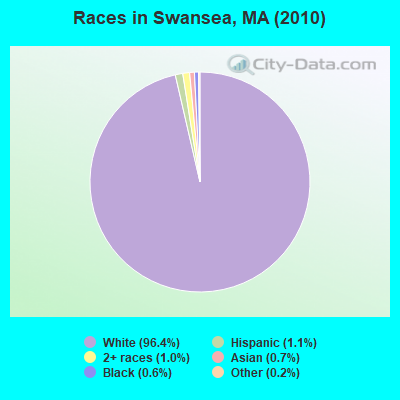
- 15,28796.4%White alone
- 1731.1%Hispanic
- 1591.0%Two or more races
- 1090.7%Asian alone
- 950.6%Black alone
- 320.2%Other race alone
- 90.06%American Indian alone
- 10.01%Native Hawaiian and Other
Pacific Islander alone
Races in Swansea detailed stats: ancestries, foreign born residents, place of birth
According to our research of Massachusetts and other state lists, there were 8 registered sex offenders living in Swansea, Massachusetts as of April 27, 2024.
The ratio of all residents to sex offenders in Swansea is 1,983 to 1.
The ratio of registered sex offenders to all residents in this city is lower than the state average.
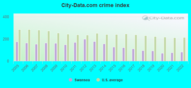
Type |
2009 |
2010 |
2011 |
2012 |
2013 |
2014 |
2015 |
2016 |
2017 |
2018 |
2019 |
2020 |
2021 |
2022 |
|---|---|---|---|---|---|---|---|---|---|---|---|---|---|---|
| Murders (per 100,000) | 0 (0.0) | 0 (0.0) | 0 (0.0) | 0 (0.0) | 1 (6.2) | 1 (6.2) | 0 (0.0) | 0 (0.0) | 0 (0.0) | 0 (0.0) | 0 (0.0) | 0 (0.0) | 0 (0.0) | 0 (0.0) |
| Rapes (per 100,000) | 1 (6.1) | 4 (25.2) | 5 (31.3) | 7 (43.7) | 5 (31.1) | 3 (18.5) | 2 (12.3) | 3 (18.3) | 2 (12.1) | 1 (6.0) | 5 (30.0) | 4 (23.7) | 5 (29.0) | 6 (34.4) |
| Robberies (per 100,000) | 6 (36.4) | 2 (12.6) | 2 (12.5) | 6 (37.4) | 7 (43.5) | 4 (24.7) | 0 (0.0) | 3 (18.3) | 6 (36.2) | 4 (24.1) | 1 (6.0) | 2 (11.9) | 1 (5.8) | 0 (0.0) |
| Assaults (per 100,000) | 43 (260.9) | 31 (195.4) | 29 (181.7) | 29 (181.0) | 21 (130.4) | 25 (154.5) | 25 (154.1) | 27 (164.5) | 15 (90.4) | 24 (144.4) | 28 (167.9) | 13 (77.1) | 16 (92.7) | 20 (114.6) |
| Burglaries (per 100,000) | 63 (382.3) | 45 (283.6) | 63 (394.7) | 90 (561.6) | 54 (335.4) | 40 (247.3) | 39 (240.4) | 29 (176.6) | 34 (204.9) | 20 (120.3) | 17 (101.9) | 18 (106.8) | 19 (110.1) | 7 (40.1) |
| Thefts (per 100,000) | 233 (1,414) | 244 (1,538) | 278 (1,742) | 277 (1,729) | 279 (1,733) | 287 (1,774) | 250 (1,541) | 205 (1,249) | 211 (1,271) | 157 (944.7) | 97 (581.5) | 86 (510.3) | 92 (533.1) | 100 (573.0) |
| Auto thefts (per 100,000) | 20 (121.4) | 12 (75.6) | 13 (81.4) | 18 (112.3) | 17 (105.6) | 6 (37.1) | 17 (104.8) | 12 (73.1) | 14 (84.4) | 16 (96.3) | 4 (24.0) | 11 (65.3) | 11 (63.7) | 14 (80.2) |
| Arson (per 100,000) | 0 (0.0) | 1 (6.3) | 1 (6.3) | 3 (18.7) | 2 (12.4) | 1 (6.2) | 0 (0.0) | 0 (0.0) | 2 (12.1) | 0 (0.0) | 0 (0.0) | 0 (0.0) | 0 (0.0) | 0 (0.0) |
| City-Data.com crime index | 161.0 | 150.5 | 169.0 | 199.8 | 177.7 | 156.8 | 127.5 | 121.1 | 110.5 | 94.8 | 91.7 | 71.1 | 77.6 | 82.6 |
The City-Data.com crime index weighs serious crimes and violent crimes more heavily. Higher means more crime, U.S. average is 246.1. It adjusts for the number of visitors and daily workers commuting into cities.
Crime rate in Swansea detailed stats: murders, rapes, robberies, assaults, burglaries, thefts, arson
Full-time law enforcement employees in 2021, including police officers: 39 (33 officers - 28 male; 5 female).
| Officers per 1,000 residents here: | 1.91 |
| Massachusetts average: | 2.53 |
 Recent articles from our blog. Our writers, many of them Ph.D. graduates or candidates, create easy-to-read articles on a wide variety of topics.

 | Cars in MA (789 replies) |
| 2021 Real Estate Observations (1729 replies) |
| Swansea Mall (the whole thing - not just a store) Closing March 31, 2019 (44 replies) |
| Be careful around the New Bedford Market Basket these days. (51 replies) |
| Coronavirus in Massachusetts (18047 replies) |
| Big MA Ancestry Data Thread by Town (31 replies) |
Latest news from Swansea, MA collected exclusively by city-data.com from local newspapers, TV, and radio stations
Ancestries: Portuguese (37.2%), Irish (18.7%), French (18.6%), English (14.2%), French Canadian (8.2%), Italian (6.0%).
Current Local Time: EST time zone
Incorporated in 1667
Elevation: 22 feet
Land area: 23.1 square miles.
Population density: 688 people per square mile (low).
1,294 residents are foreign born (6.7% Europe).
| This town: | 8.1% |
| Massachusetts: | 12.2% |
| Swansea town: | 1.2% ($1,628) |
| Massachusetts: | 1.3% ($2,336) |
Nearest city with pop. 50,000+: Fall River, MA  (4.6 miles , pop. 91,938).
Nearest city with pop. 200,000+: Boston, MA (40.6 miles , pop. 589,141).
Nearest city with pop. 1,000,000+: Bronx, NY (151.4 miles , pop. 1,332,650).
Nearest cities:
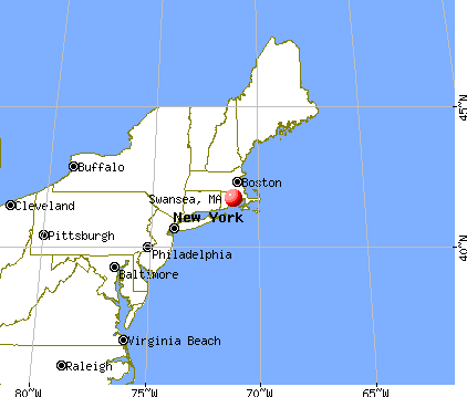
Latitude: 41.74 N, Longitude: 71.21 W

Swansea tourist attractions:
Swansea, Massachusetts accommodation & food services, waste management - Economy and Business Data
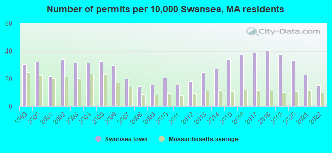
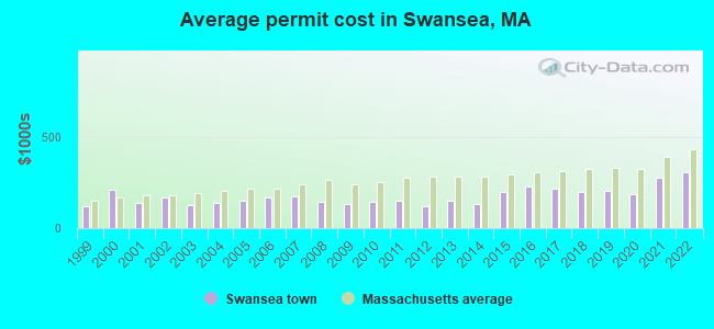
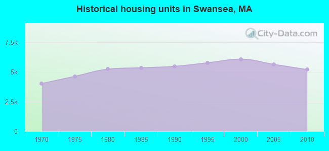
Single-family new house construction building permits:
- 2022: 24 buildings, average cost: $308,000
- 2021: 36 buildings, average cost: $275,600
- 2020: 53 buildings, average cost: $187,800
- 2019: 60 buildings, average cost: $207,800
- 2018: 64 buildings, average cost: $200,500
- 2017: 62 buildings, average cost: $219,200
- 2016: 60 buildings, average cost: $226,800
- 2015: 54 buildings, average cost: $196,600
- 2014: 43 buildings, average cost: $130,100
- 2013: 39 buildings, average cost: $152,400
- 2012: 29 buildings, average cost: $121,300
- 2011: 25 buildings, average cost: $153,600
- 2010: 33 buildings, average cost: $142,200
- 2009: 25 buildings, average cost: $134,300
- 2008: 23 buildings, average cost: $145,100
- 2007: 32 buildings, average cost: $172,900
- 2006: 47 buildings, average cost: $171,000
- 2005: 52 buildings, average cost: $150,400
- 2004: 50 buildings, average cost: $138,600
- 2003: 50 buildings, average cost: $127,500
- 2002: 54 buildings, average cost: $167,500
- 2001: 35 buildings, average cost: $136,500
- 2000: 51 buildings, average cost: $211,200
- 1999: 48 buildings, average cost: $122,900
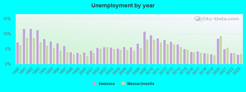
| Here: | 3.2% |
| Massachusetts: | 3.5% |
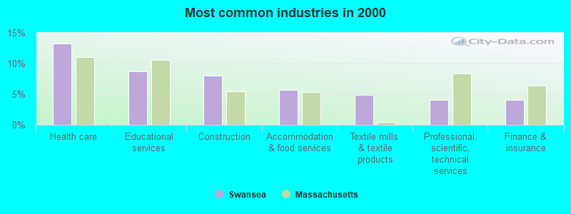
- Health care (13.2%)
- Educational services (8.8%)
- Construction (8.1%)
- Accommodation & food services (5.7%)
- Textile mills & textile products (4.9%)
- Professional, scientific, technical services (4.1%)
- Finance & insurance (4.0%)
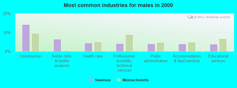
- Construction (14.2%)
- Textile mills & textile products (6.6%)
- Health care (4.5%)
- Professional, scientific, technical services (4.1%)
- Public administration (4.1%)
- Accommodation & food services (4.0%)
- Educational services (3.8%)
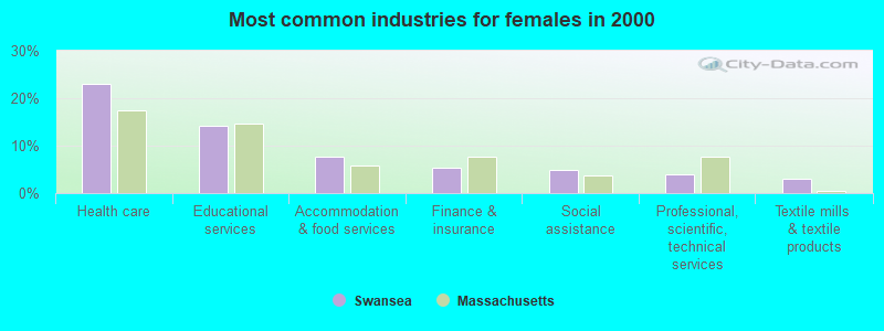
- Health care (23.0%)
- Educational services (14.3%)
- Accommodation & food services (7.6%)
- Finance & insurance (5.4%)
- Social assistance (4.9%)
- Professional, scientific, technical services (4.0%)
- Textile mills & textile products (3.0%)
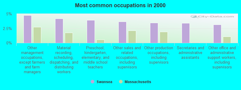
- Other management occupations, except farmers and farm managers (4.7%)
- Material recording, scheduling, dispatching, and distributing workers (4.2%)
- Preschool, kindergarten, elementary, and middle school teachers (3.9%)
- Other sales and related occupations, including supervisors (3.7%)
- Other production occupations, including supervisors (3.5%)
- Secretaries and administrative assistants (3.4%)
- Other office and administrative support workers, including supervisors (3.2%)
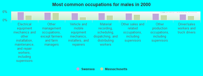
- Electrical equipment mechanics and other installation, maintenance, and repair workers, including supervisors (5.8%)
- Other management occupations, except farmers and farm managers (5.5%)
- Vehicle and mobile equipment mechanics, installers, and repairers (5.1%)
- Material recording, scheduling, dispatching, and distributing workers (5.1%)
- Other sales and related occupations, including supervisors (5.0%)
- Other production occupations, including supervisors (4.7%)
- Driver/sales workers and truck drivers (4.3%)

- Preschool, kindergarten, elementary, and middle school teachers (7.4%)
- Secretaries and administrative assistants (7.2%)
- Registered nurses (5.8%)
- Other office and administrative support workers, including supervisors (5.0%)
- Nursing, psychiatric, and home health aides (4.1%)
- Other management occupations, except farmers and farm managers (3.9%)
- Health technologists and technicians (3.9%)
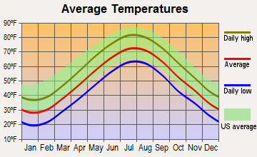
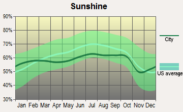
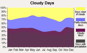
Average climate in Swansea, Massachusetts
Based on data reported by over 4,000 weather stations
(lower is better)
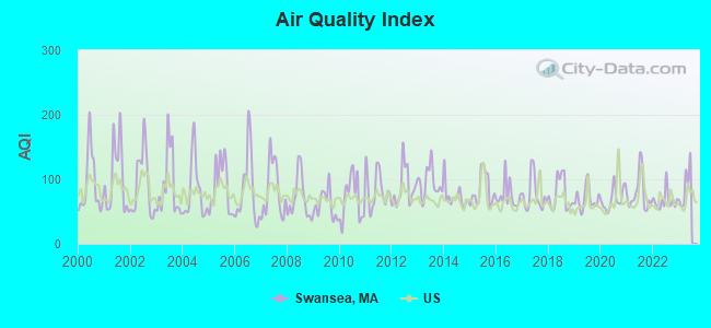
Air Quality Index (AQI) level in 2022 was 66.8. This is about average.
| City: | 66.8 |
| U.S.: | 72.6 |
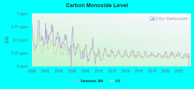
Carbon Monoxide (CO) [ppm] level in 2022 was 0.196. This is better than average. Closest monitor was 10.2 miles away from the city center.
| City: | 0.196 |
| U.S.: | 0.251 |
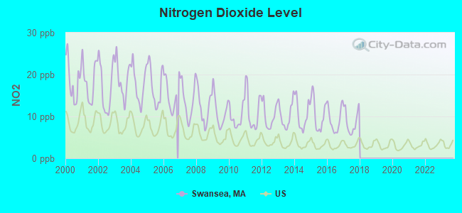
Nitrogen Dioxide (NO2) [ppb] level in 2017 was 8.78. This is significantly worse than average. Closest monitor was 4.2 miles away from the city center.
| City: | 8.78 |
| U.S.: | 5.11 |
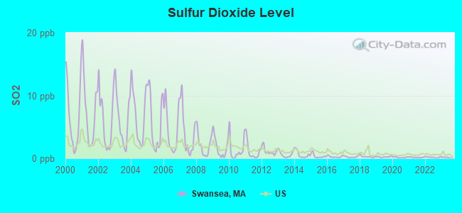
Sulfur Dioxide (SO2) [ppb] level in 2022 was 0.179. This is significantly better than average. Closest monitor was 1.2 miles away from the city center.
| City: | 0.179 |
| U.S.: | 1.515 |
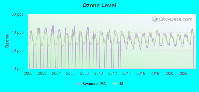
Ozone [ppb] level in 2022 was 32.3. This is about average. Closest monitor was 4.5 miles away from the city center.
| City: | 32.3 |
| U.S.: | 33.3 |
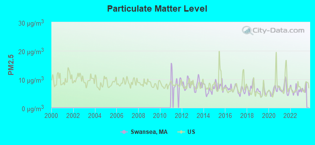
Particulate Matter (PM2.5) [µg/m3] level in 2022 was 6.05. This is better than average. Closest monitor was 4.5 miles away from the city center.
| City: | 6.05 |
| U.S.: | 8.11 |
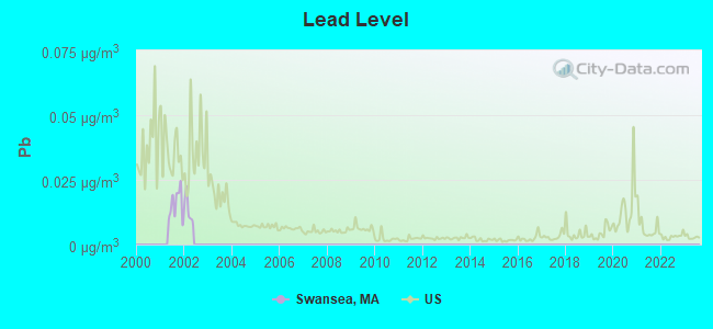
Lead (Pb) [µg/m3] level in 2001 was 0.0155. This is significantly worse than average. Closest monitor was 4.3 miles away from the city center.
| City: | 0.0155 |
| U.S.: | 0.0093 |
Tornado activity:
Swansea-area historical tornado activity is below Massachusetts state average. It is 59% smaller than the overall U.S. average.
On 6/9/1953, a category F3 (max. wind speeds 158-206 mph) tornado 21.3 miles away from the Swansea town center injured 17 people and caused between $500,000 and $5,000,000 in damages.
On 6/9/1953, a category F4 (max. wind speeds 207-260 mph) tornado 41.7 miles away from the town center killed 90 people and injured 1228 people and caused between $50,000,000 and $500,000,000 in damages.
Earthquake activity:
Swansea-area historical earthquake activity is significantly above Massachusetts state average. It is 74% smaller than the overall U.S. average.On 10/7/1983 at 10:18:46, a magnitude 5.3 (5.1 MB, 5.3 LG, 5.1 ML, Class: Moderate, Intensity: VI - VII) earthquake occurred 220.3 miles away from the city center
On 4/20/2002 at 10:50:47, a magnitude 5.3 (5.3 ML, Depth: 3.0 mi) earthquake occurred 229.0 miles away from the city center
On 1/19/1982 at 00:14:42, a magnitude 4.7 (4.5 MB, 4.7 MD, 4.5 LG, Class: Light, Intensity: IV - V) earthquake occurred 123.2 miles away from the city center
On 4/20/2002 at 10:50:47, a magnitude 5.2 (5.2 MB, 4.2 MS, 5.2 MW, 5.0 MW) earthquake occurred 228.1 miles away from the city center
On 10/16/2012 at 23:12:25, a magnitude 4.7 (4.7 ML, Depth: 10.0 mi) earthquake occurred 131.5 miles away from the city center
On 8/22/1992 at 12:20:32, a magnitude 4.8 (4.8 MB, 3.8 MS, 4.7 LG, Depth: 6.2 mi) earthquake occurred 188.3 miles away from Swansea center
Magnitude types: regional Lg-wave magnitude (LG), body-wave magnitude (MB), duration magnitude (MD), local magnitude (ML), surface-wave magnitude (MS), moment magnitude (MW)
Natural disasters:
The number of natural disasters in Bristol County (23) is greater than the US average (15).Major Disasters (Presidential) Declared: 12
Emergencies Declared: 11
Causes of natural disasters: Floods: 8, Hurricanes: 7, Storms: 5, Snows: 3, Snowstorms: 3, Winter Storms: 3, Blizzards: 2, Explosion: 1, Heavy Rain: 1, Snowfall: 1, Tropical Storm: 1, Wind: 1 (Note: some incidents may be assigned to more than one category).
Main business address for: FIRSTFED AMERICA BANCORP INC (SAVINGS INSTITUTION, FEDERALLY CHARTERED).
Hospitals and medical centers in Swansea:
Amtrak station near Swansea:
Colleges/universities with over 2000 students nearest to Swansea:
- Bristol Community College (about 6 miles; Fall River, MA; Full-time enrollment: 5,707)
- Roger Williams University (about 7 miles; Bristol, RI; FT enrollment: 4,375)
- Brown University (about 12 miles; Providence, RI; FT enrollment: 8,458)
- Rhode Island School of Design (about 12 miles; Providence, RI; FT enrollment: 2,714)
- Johnson & Wales University-Providence (about 12 miles; Providence, RI; FT enrollment: 10,898)
- University of Massachusetts-Dartmouth (about 14 miles; North Dartmouth, MA; FT enrollment: 7,545)
- Providence College (about 14 miles; Providence, RI; FT enrollment: 4,312)
Public high school in Swansea:
- JOSEPH CASE HIGH (Students: 597, Location: 70 SCHOOL STREET, Grades: 9-12)
Private high schools in Swansea:
- NEW ENGLAND CHRISTIAN ACADEMY (Students: 138, Location: 271 SHARPS LOT RD, Grades: PK-12)
- STEVENS CHILDRENS HOME (Students: 30, Location: 24 MAIN ST, Grades: 8-12, Boys only)
- MEADOWRIDGE BEHAVIORAL HEALTH CENTER (Students: 28, Location: 664 STEVENS RD, Grades: 8-12)
- SWANSEA WOOD SCHOOL (Students: 26, Location: 789 STEVENS RD, Grades: 8-12)
Public elementary/middle schools in Swansea:
- JOSEPH CASE JR HIGH (Students: 554, Location: 195 MAIN STREET, Grades: 6-8)
- MARK G HOYLE ELEMENTARY (Students: 259, Location: 70 COMMUNITY LANE, Grades: PK-2)
- GARDNER (Students: 250, Location: 10 CHURCH STREET, Grades: KG-2)
- ELIZABETH S BROWN (Students: 247, Location: 29 GARDNERS NECK ROAD, Grades: 3-5)
- JOSEPH G LUTHER (Students: 221, Location: 100 PEARSE ROAD, Grades: 3-5)
Points of interest:
Notable locations in Swansea: Touisset Country Club (A), Swansea Ambulance Corps (B), Swansea Fire Department Station 3 (C), Swansea Fire Department Station 1 (D), Swansea Fire Department Station 4 (E), Swansea Fire Department Station 2 (F), Swansea Town Hall (G). Display/hide their locations on the map
Shopping Centers: Swansea Mall (1), Swansea II Shopping Center (2). Display/hide their locations on the map
Main business address in Swansea: FIRSTFED AMERICA BANCORP INC (A). Display/hide its location on the map
Cemeteries: Mount Hope Cemetery (1), Eddy Cemetery (2), Chace Cemetery (3), Thomas Cemetery (4). Display/hide their locations on the map
Reservoirs and swamps: Cole River Pond (A), Lewin Brook Pond (B), Mount Hope Pond (C), Lewin Brook Pond (D), Milford Pond (E), Warren Reservoir (F), Birch Swamp (G). Display/hide their locations on the map
Streams, rivers, and creeks: Lewin Brook (A), Heath Brook (B), Cole River (C). Display/hide their locations on the map
Tourist attraction: Martin House Farm (Cultural Attractions- Events- & Facilities; 22 Stoney Hill Road) (1). Display/hide its approximate location on the map
Drinking water stations with addresses in Swansea and their reported violations in the past:
SWANSEA WATER DISTRICT (Population served: 16,254, Surface water):Past health violations:
- MCL, Monthly (TCR) - In SEP-2011, Contaminant: Coliform. Follow-up actions: St AO (w/o penalty) issued (NOV-29-2011), St Compliance achieved (NOV-29-2011)
| This town: | 2.6 people |
| Massachusetts: | 2.5 people |
| This town: | 74.0% |
| Whole state: | 63.0% |
| This town: | 6.1% |
| Whole state: | 7.0% |
Likely homosexual households (counted as self-reported same-sex unmarried-partner households)
- Lesbian couples: 0.4% of all households
- Gay men: 0.4% of all households
| This town: | 4.9% |
| Whole state: | 9.3% |
| This town: | 2.1% |
| Whole state: | 4.4% |
People in group quarters in Swansea in 2010:
- 82 people in nursing facilities/skilled-nursing facilities
- 40 people in group homes intended for adults
- 32 people in workers' group living quarters and job corps centers
- 29 people in residential treatment centers for juveniles (non-correctional)
- 28 people in residential schools for people with disabilities
- 2 people in other noninstitutional facilities
People in group quarters in Swansea in 2000:
- 99 people in nursing homes
- 29 people in training schools for juvenile delinquents
- 26 people in schools, hospitals, or wards for the intellectually disabled
- 25 people in homes for the mentally retarded
- 9 people in other group homes
- 8 people in homes for the mentally ill
- 6 people in homes or halfway houses for drug/alcohol abuse
- 2 people in religious group quarters
Banks with branches in Swansea (2011 data):
- Sovereign Bank, National Association: Swansea Branch at 620 G.A.r. Highway, branch established on 1974/08/14. Info updated 2012/01/31: Bank assets: $78,146.9 mil, Deposits: $48,042.9 mil, headquarters in Wilmington, DE, positive income, Commercial Lending Specialization, 718 total offices, Holding Company: Banco Santander, S.A.
- BayCoast Bank: Swansea Branch at 554 Wilbur Avenue, branch established on 1975/02/10. Info updated 2012/02/03: Bank assets: $909.2 mil, Deposits: $730.3 mil, headquarters in Fall River, MA, positive income, Commercial Lending Specialization, 14 total offices, Holding Company: Narragansett Financial Corp
- BankFive: Swansea Branch at 497 Milford Road, branch established on 1976/02/02. Info updated 2011/11/15: Bank assets: $720.6 mil, Deposits: $613.3 mil, headquarters in Fall River, MA, positive income, Commercial Lending Specialization, 13 total offices, Holding Company: Bankfive, Mhc
- Mechanics' Co-operative Bank: 201 Gar Hwy Branch at 201 Gar Highway, branch established on 1986/06/30. Info updated 2011/09/20: Bank assets: $386.4 mil, Deposits: $340.4 mil, headquarters in Taunton, MA, positive income, Commercial Lending Specialization, 8 total offices, Holding Company: Mechanics Bancorp, Mhc
For population 15 years and over in Swansea:
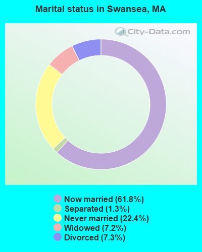
- Never married: 22.4%
- Now married: 61.8%
- Separated: 1.3%
- Widowed: 7.2%
- Divorced: 7.3%
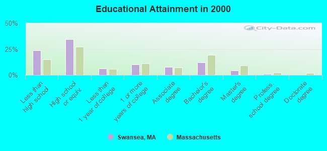
For population 25 years and over in Swansea:
- High school or higher: 76.4%
- Bachelor's degree or higher: 17.6%
- Graduate or professional degree: 5.5%
- Unemployed: 3.4%
- Mean travel time to work (commute): 23.4 minutes
| Here: | 13.0 |
| Massachusetts average: | 13.1 |
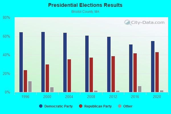
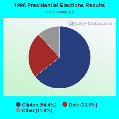
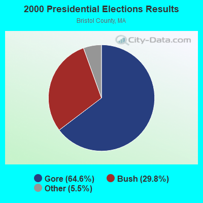
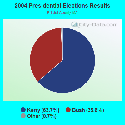
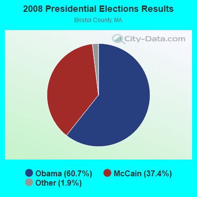
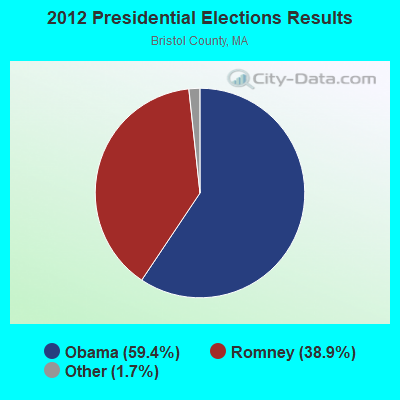


Graphs represent county-level data. Detailed 2008 Election Results
Religion statistics for Swansea, MA (based on Bristol County data)
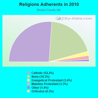
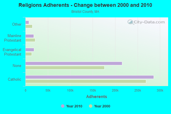
| Religion | Adherents | Congregations |
|---|---|---|
| Catholic | 286,113 | 72 |
| Evangelical Protestant | 18,765 | 128 |
| Mainline Protestant | 18,246 | 83 |
| Other | 7,807 | 33 |
| Orthodox | 1,565 | 4 |
| Black Protestant | 511 | 5 |
| None | 215,278 | - |
Food Environment Statistics:
| Bristol County: | 2.00 / 10,000 pop. |
| Massachusetts: | 1.98 / 10,000 pop. |
| Here: | 0.09 / 10,000 pop. |
| Massachusetts: | 0.05 / 10,000 pop. |
| This county: | 1.93 / 10,000 pop. |
| State: | 2.22 / 10,000 pop. |
| This county: | 2.35 / 10,000 pop. |
| Massachusetts: | 1.77 / 10,000 pop. |
| Bristol County: | 8.20 / 10,000 pop. |
| Massachusetts: | 8.76 / 10,000 pop. |
| Bristol County: | 9.5% |
| State: | 8.1% |
| Here: | 26.9% |
| Massachusetts: | 22.5% |
| Bristol County: | 14.4% |
| Massachusetts: | 16.5% |
4.76% of this county's 2021 resident taxpayers lived in other counties in 2020 ($70,162 average adjusted gross income)
| Here: | 4.76% |
| Massachusetts average: | 6.35% |
0.01% of residents moved from foreign countries ($64 average AGI)
Bristol County: 0.01% Massachusetts average: 0.01%
Top counties from which taxpayers relocated into this county between 2020 and 2021:
| from Plymouth County, MA | |
| from Norfolk County, MA | |
| from Providence County, RI |
4.63% of this county's 2020 resident taxpayers moved to other counties in 2021 ($72,404 average adjusted gross income)
| Here: | 4.63% |
| Massachusetts average: | 7.18% |
0.01% of residents moved to foreign countries ($83 average AGI)
Bristol County: 0.01% Massachusetts average: 0.02%
Top counties to which taxpayers relocated from this county between 2020 and 2021:
| to Plymouth County, MA | |
| to Providence County, RI | |
| to Norfolk County, MA |
| Businesses in Swansea, MA | ||||
| Name | Count | Name | Count | |
|---|---|---|---|---|
| AT&T | 1 | MasterBrand Cabinets | 4 | |
| Aeropostale | 1 | McDonald's | 2 | |
| Ashley Furniture | 1 | Men's Wearhouse | 1 | |
| Bath & Body Works | 1 | Motherhood Maternity | 1 | |
| Circle K | 1 | Nike | 3 | |
| Deb | 1 | Old Navy | 1 | |
| Dunkin Donuts | 6 | Pac Sun | 1 | |
| Express | 1 | Payless | 1 | |
| Famous Footwear | 1 | Penske | 1 | |
| FedEx | 3 | RadioShack | 1 | |
| Finish Line | 1 | Rite Aid | 1 | |
| Firestone Complete Auto Care | 1 | Ruby Tuesday | 1 | |
| GNC | 1 | Rue21 | 1 | |
| GameStop | 1 | Sears | 2 | |
| H&R Block | 1 | Spencer Gifts | 1 | |
| Haagen-Dazs | 1 | Subway | 2 | |
| Holiday Inn | 1 | T-Mobile | 1 | |
| Jones New York | 1 | Toys"R"Us | 1 | |
| Justice | 1 | U-Haul | 1 | |
| Lane Bryant | 1 | UPS | 2 | |
| Lane Furniture | 1 | Victoria's Secret | 1 | |
| Macy's | 1 | Walmart | 1 | |
| Marshalls | 1 | Wendy's | 1 | |
Strongest AM radio stations in Swansea:
- WSAR (1480 AM; 5 kW; FALL RIVER, MA; Owner: BRISTOL COUNTY BROADCASTING, INC.)
- WPRO (630 AM; 5 kW; PROVIDENCE, RI; Owner: CITADEL BROADCASTING COMPANY)
- WHJJ (920 AM; 5 kW; PROVIDENCE, RI)
- WALE (990 AM; 50 kW; GREENVILLE, RI; Owner: NORTH AMERICAN BROADCASTING CO., INC.)
- WSKO (790 AM; 5 kW; PROVIDENCE, RI; Owner: CITADEL BROADCASTING COMPANY)
- WPMZ (1110 AM; daytime; 5 kW; EAST PROVIDENCE, RI; Owner: VIDEO MUNDO B/CASTING CO., LLC)
- WEEI (850 AM; 50 kW; BOSTON, MA; Owner: ENTERCOM BOSTON LICENSE, LLC)
- WRNI (1290 AM; 10 kW; PROVIDENCE, RI; Owner: WRNI FOUNDATION)
- WDDZ (550 AM; 5 kW; PAWTUCKET, RI; Owner: ABC, INC.)
- WBZ (1030 AM; 50 kW; BOSTON, MA; Owner: INFINITY BROADCASTING OPERATIONS, INC.)
- WHTB (1400 AM; 1 kW; FALL RIVER, MA; Owner: SNE BROADCASTING, LTD.(A MASS. CORP))
- WKOX (1200 AM; 50 kW; FRAMINGHAM, MA; Owner: CAPSTAR TX LIMITED PARTNERSHIP)
- WRKO (680 AM; 50 kW; BOSTON, MA; Owner: ENTERCOM BOSTON LICENSE, LLC)
Strongest FM radio stations in Swansea:
- WWBB (101.5 FM; PROVIDENCE, RI; Owner: CLEAR CHANNEL BROADCASTING LICENSES, INC.)
- WSNE-FM (93.3 FM; TAUNTON, MA; Owner: CAPSTAR TX LIMITED PARTNERSHIP)
- WBRU (95.5 FM; PROVIDENCE, RI; Owner: BROWN BROADCASTING SERVICE, INC.)
- WKKB (100.3 FM; MIDDLETOWN, RI; Owner: CITADEL BROADCASTING COMPANY)
- WHJY (94.1 FM; PROVIDENCE, RI; Owner: CAPSTAR TX LIMITED PARTNERSHIP)
- WPRO-FM (92.3 FM; PROVIDENCE, RI; Owner: CITADEL BROADCASTING COMPANY)
- WWLI (105.1 FM; PROVIDENCE, RI; Owner: CITADEL BROADCASTING COMPANY)
- WCTK (98.1 FM; NEW BEDFORD, MA; Owner: HALL COMMUNICATIONS, INC.)
- WJFD-FM (97.3 FM; NEW BEDFORD, MA; Owner: EDMUND DINIS, TRUSTEE)
- WSMU-FM (91.1 FM; NORTH DARTMOUTH, MA; Owner: UNIVERSITY OF MASSACHUSETTS)
- WBMX (98.5 FM; BOSTON, MA; Owner: INFINITY RADIO OPERATIONS INC.)
- WBOS (92.9 FM; BROOKLINE, MA; Owner: GREATER BOSTON RADIO, INC.)
- WJMN (94.5 FM; BOSTON, MA; Owner: AMFM RADIO LICENSES, L.L.C.)
- WCRB (102.5 FM; WALTHAM, MA; Owner: CHARLES RIVER BROADCASTING WCRB LICE)
- WTKK (96.9 FM; BOSTON, MA; Owner: GREATER BOSTON RADIO, INC.)
- WROR-FM (105.7 FM; FRAMINGHAM, MA; Owner: GREATER BOSTON RADIO, INC.)
- WWKX (106.3 FM; WOONSOCKET, RI; Owner: AAA ENTERTAINMENT LICENSING LLC)
- WXKS-FM (107.9 FM; MEDFORD, MA; Owner: AMFM RADIO LICENSES, L.L.C.)
- WFHN (107.1 FM; FAIRHAVEN, MA; Owner: CITADEL BROADCASTING COMPANY)
- WGBH (89.7 FM; BOSTON, MA; Owner: WGBH EDUCATIONAL FOUNDATION)
TV broadcast stations around Swansea:
- WLNE-TV (Channel 6; NEW BEDFORD, MA; Owner: FREEDOM BROADCASTING OF SOUTHERN NEW ENGLAND, INC.)
- WNAC-TV (Channel 64; PROVIDENCE, RI; Owner: WNAC, LLC)
- WJAR (Channel 10; PROVIDENCE, RI; Owner: OUTLET BROADCASTING, INC.)
- WPRI-TV (Channel 12; PROVIDENCE, RI; Owner: TVL BROADCASTING OF RHODE ISLAND, LLC)
- WSBE-TV (Channel 36; PROVIDENCE, RI; Owner: RHODE ISLAND PUBLIC TELECOM. AUTHORITY)
- WLWC (Channel 28; NEW BEDFORD, MA; Owner: C-28 FCC LICENSEE SUBSIDIARY, LLC)
- WWDP (Channel 46; NORWELL, MA; Owner: NORWELL TELEVISION, LLC)
- WPXQ (Channel 69; BLOCK ISLAND, RI; Owner: OCEAN STATE TELEVISION, L.L.C.)
- WCVB-TV (Channel 5; BOSTON, MA; Owner: WCVB HEARST-ARGYLE TV, INC.)
- WGBH-TV (Channel 2; BOSTON, MA; Owner: WGBH EDUCATIONAL FOUNDATION)
- WHDH-TV (Channel 7; BOSTON, MA; Owner: WHDH-TV)
- WMFP (Channel 62; LAWRENCE, MA; Owner: WSAH LICENSE, INC.)
- WSBK-TV (Channel 38; BOSTON, MA; Owner: VIACOM INC.)
- WLVI-TV (Channel 56; CAMBRIDGE, MA; Owner: WLVI, INC.)
- WBZ-TV (Channel 4; BOSTON, MA; Owner: VIACOM INC.)
- WGBX-TV (Channel 44; BOSTON, MA; Owner: WGBH EDUCATIONAL FOUNDATION)
- WRIW-LP (Channel 50; PROVIDENCE, RI; Owner: ZGS PROVIDENCE, INC.)
- WFXT (Channel 25; BOSTON, MA; Owner: FOX TELEVISION STATIONS INC.)
- WUNI (Channel 27; WORCESTER, MA; Owner: ENTRAVISION HOLDINGS, LLC)
- WUTF (Channel 66; MARLBOROUGH, MA; Owner: TELEFUTURA BOSTON LLC)
- WBPX (Channel 68; BOSTON, MA; Owner: PAXSON BOSTON-68 LICENSE, INC.)
- W40BO (Channel 40; BOSTON, MA; Owner: PAXSON COMMUNICATIONS LPTV, INC.)
- National Bridge Inventory (NBI) Statistics
- 19Number of bridges
- 226ft / 69.2mTotal length
- $48,928,000Total costs
- 542,688Total average daily traffic
- 6,679Total average daily truck traffic
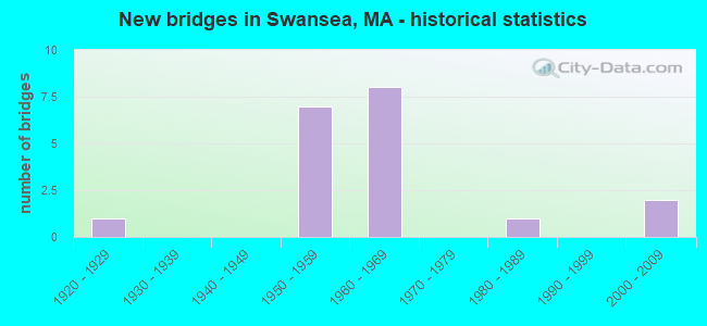
- New bridges - historical statistics
- 11920-1929
- 71950-1959
- 81960-1969
- 11980-1989
- 22000-2009
FCC Registered Antenna Towers:
29 (See the full list of FCC Registered Antenna Towers in Swansea)FCC Registered Broadcast Land Mobile Towers:
10 (See the full list of FCC Registered Broadcast Land Mobile Towers in Swansea, MA)FCC Registered Microwave Towers:
4- BOS2417, 2238 Gar Highway (091554) (Lat: 41.770139 Lon: -71.261083), Type: Tower, Structure height: 46 m, Overall height: 48.5 m, Call Sign: WQFP971, Licensee ID: L01728370,
Assigned Frequencies: 21875.0 MHz, 19380.0 MHz, Grant Date: 09/06/2006, Expiration Date: 09/06/2016, Cancellation Date: 09/09/2013, Certifier: Joseph M Sandri Jr., Registrant: Fibertower Network Services, Corp., Debtor-In-Possession, 1875 Eye Street, Nw, 5th Floor, Room 505, Washington, DC 20006, Phone: (202) 223-1028, Email:
- Swansea, G.A.R. Highway (Lat: 41.746639 Lon: -71.207611), Type: Mast, Structure height: 48.8 m, Call Sign: WQIW430,
Assigned Frequencies: 10567.5 MHz, Grant Date: 06/03/2008, Expiration Date: 06/03/2018, Cancellation Date: 08/11/2015, Certifier: Pamelia Y Hoof, Registrant: Verizon Wireless, 1120 Sanctuary Pkwy, #150 Gasa5reg, Alpharetta, GA 30009-7630, Phone: (770) 797-1070, Fax: (770) 797-1036, Email:
- BS54XC884, 2283 Gar Hwy (091554) (Lat: 41.770167 Lon: -71.261083), Type: Tower, Structure height: 51.7 m, Overall height: 52.4 m, Call Sign: WQPV922,
Assigned Frequencies: 19475.0 MHz, 19475.0 MHz, 19475.0 MHz, 19475.0 MHz, Grant Date: 08/27/2012, Expiration Date: 08/27/2022, Cancellation Date: 08/24/2022, Certifier: David Werblow, Registrant: Dla Piper LLP, 500 8th Street, Nw, Washington, DC 20004, Phone: (202) 799-4216, Fax: (202) 799-5616, Email:
- SWANSEA RT 6, 2283 Gar Highway (Lat: 41.770167 Lon: -71.261083), Type: Ltower, Structure height: 51.8 m, Overall height: 52.4 m, Call Sign: WQQD681,
Assigned Frequencies: 11175.0 MHz, Grant Date: 10/04/2022, Expiration Date: 11/09/2032, Certifier: John E Monday, Registrant: At&t Services, Inc., 208 S Akard St, 20f, Dallas, TX 75202, Phone: (855) 699-7073, Email:
FCC Registered Amateur Radio Licenses:
94 (See the full list of FCC Registered Amateur Radio Licenses in Swansea)FAA Registered Aircraft:
5- Aircraft: PIPER PA-28-180 (Category: Land, Seats: 4, Weight: Up to 12,499 Pounds, Speed: 107 mph), Engine: LYCOMING O&VO-360 SER (180 HP) (Reciprocating)
N-Number: 511RF, N511RF, N-511RF, Serial Number: 28-7105167, Year manufactured: 1971, Airworthiness Date: 06/09/1971, Certificate Issue Date: 07/14/2015
Registrant (Individual): Edward Derek Laffey, 24 James Birch Ln, Swansea, MA 02777 - Aircraft: PIPER PA-28-140 (Category: Land, Seats: 4, Weight: Up to 12,499 Pounds, Speed: 107 mph), Engine: LYCOMING 0-320 SERIES (180 HP) (Reciprocating)
N-Number: 5744U, N5744U, N-5744U, Serial Number: 28-26564, Year manufactured: 1970, Airworthiness Date: 02/19/1970, Certificate Issue Date: 05/27/2020
Registrant (Individual): Nathan J Hickney, 33 Sgt Harrington Dr, Swansea, MA 02777 - Aircraft: CESSNA 172 (Category: Land, Seats: 4, Weight: Up to 12,499 Pounds, Speed: 105 mph), Engine: CONT MOTOR 0-300 SER (145 HP) (Reciprocating)
N-Number: 9156N, N9156N, N-9156N, Serial Number: 28648, Year manufactured: 1956, Airworthiness Date: 07/07/1989, Certificate Issue Date: 06/22/1990
Registrant (Co-Owned): Kenneth M Burdick, 166 Pinehurst Ave #17, Swansea, MA 02777, Other Owners: Marie E Burdick - Aircraft: PIPER J4A (Category: Land, Seats: 2, Weight: Up to 12,499 Pounds, Speed: 75 mph), Engine: CONT MOTOR A&C65 SERIES (65 HP) (Reciprocating)
N-Number: 24782, N24782, N-24782, Serial Number: 4715, Year manufactured: 1939
Registrant (Individual): Joseph E Rogers, 33 Ashmont St, Swansea, MA 02777
Deregistered: Cancel Date: 03/06/2020 - Aircraft: PIPER PA-32-300 (Category: Land, Seats: 6, Weight: Up to 12,499 Pounds, Speed: 126 mph), Engine: LYCOMING TI0-540 SER (310 HP) (Reciprocating)
N-Number: 41545, N41545, N-41545, Serial Number: 32-7440097, Airworthiness Date: 07/31/1974, Certificate Issue Date: 05/15/2017
Registrant (Individual): Robert P Lee, 800 Pearse Rd, Swansea, MA 02777
2002 - 2018 National Fire Incident Reporting System (NFIRS) incidents
- Fire incident types reported to NFIRS in Swansea, MA
- 69844.4%Structure Fires
- 59537.9%Outside Fires
- 25816.4%Mobile Property/Vehicle Fires
- 201.3%Other
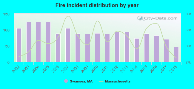 Based on the data from the years 2002 - 2018 the average number of fire incidents per year is 92. The highest number of reported fire incidents - 125 took place in 2005, and the least - 47 in 2018. The data has a declining trend.
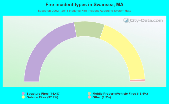 When looking into fire subcategories, the most reports belonged to: Structure Fires (44.4%), and Outside Fires (37.9%).
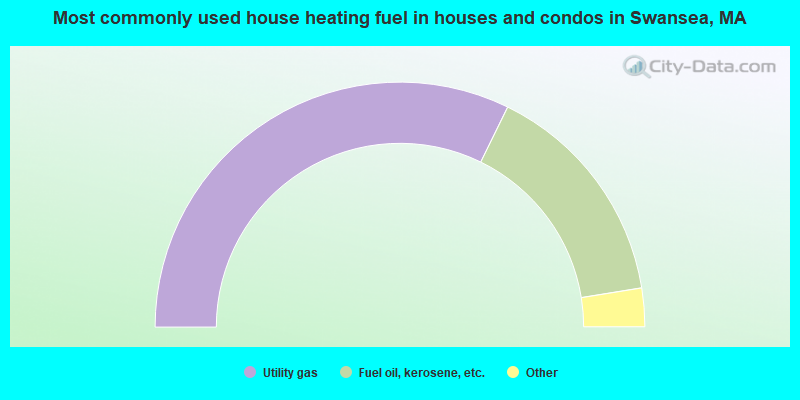
- 64.5%Utility gas
- 30.4%Fuel oil, kerosene, etc.
- 2.6%Electricity
- 1.4%Bottled, tank, or LP gas
- 0.9%Wood
- 0.2%No fuel used
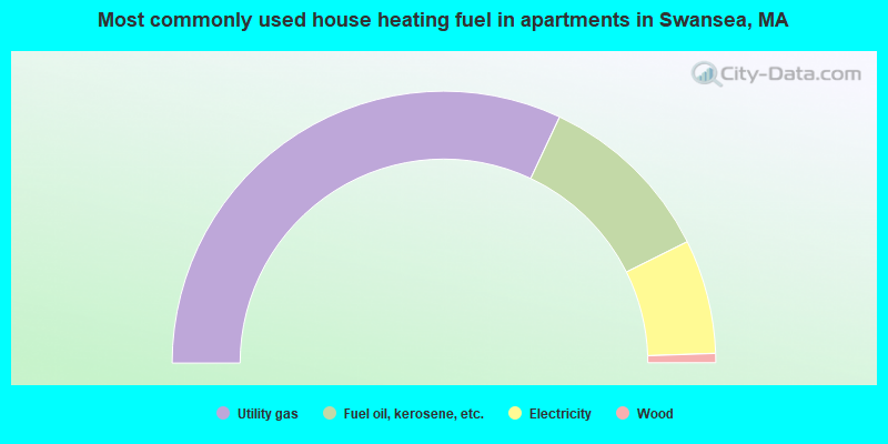
- 64.0%Utility gas
- 21.3%Fuel oil, kerosene, etc.
- 13.6%Electricity
- 1.1%Wood
Swansea compared to Massachusetts state average:
- Unemployed percentage significantly below state average.
- Black race population percentage significantly below state average.
- Hispanic race population percentage significantly below state average.
- Median age above state average.
- Foreign-born population percentage below state average.
- Renting percentage significantly below state average.
- Length of stay since moving in significantly above state average.
- Number of rooms per house significantly below state average.
- House age significantly below state average.
- Percentage of population with a bachelor's degree or higher below state average.
Swansea on our top lists:
- #25 on the list of "Top 101 cities with largest percentage of males in industries: textile mills and textile products (population 5,000+)"
- #32 on the list of "Top 101 cities with largest percentage of males in industries: personal and laundry services (population 5,000+)"
- #40 on the list of "Top 101 cities with largest percentage of males in occupations: textile, apparel, and furnishings workers (population 5,000+)"
- #40 on the list of "Top 101 cities with largest percentage of males in industries: office supplies and stationery stores (population 5,000+)"
- #48 on the list of "Top 101 cities with largest percentage of males in industries: retail florists (population 5,000+)"
- #50 on the list of "Top 101 cities with largest percentage of females in industries: paper and paper products merchant wholesalers (population 5,000+)"
- #53 on the list of "Top 101 cities with largest percentage of females in industries: textile mills and textile products (population 5,000+)"
- #55 on the list of "Top 101 cities with largest percentage of females in industries: health care (population 5,000+)"
- #61 on the list of "Top 101 cities with largest percentage of females in occupations: financial clerks except bookkeeping, accounting, and auditing clerks (population 5,000+)"
- #61 on the list of "Top 101 cities with largest percentage of males in industries: furniture and home furnishing merchant wholesalers (population 5,000+)"
- #85 on the list of "Top 101 cities with largest percentage of males in occupations: material recording, scheduling, dispatching, and distributing workers (population 5,000+)"
- #89 on the list of "Top 101 cities with largest percentage of males in industries: apparel (population 5,000+)"
- #91 on the list of "Top 101 cities with largest percentage of males in industries: u. s. postal service (population 5,000+)"
- #38 (02777) on the list of "Top 101 zip codes with the largest percentage of Portuguese first ancestries"
- #14 on the list of "Top 101 counties with the lowest percentage of residents that keep firearms around their homes"
- #29 on the list of "Top 101 counties with the lowest percentage of residents relocating to foreign countries in 2011 (pop. 50,000+)"
- #32 on the list of "Top 101 counties with the most Catholic congregations"
- #34 on the list of "Top 101 counties with the highest percentage of residents that smoked 100+ cigarettes in their lives"
- #41 on the list of "Top 101 counties with the most Catholic adherents"

|
|
Total of 54 patent applications in 2008-2024.