Westport, California
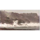
Westport: Coastline
Westport: Coastline
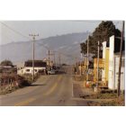
Westport: Grocery Store, Post Office, Gas Station
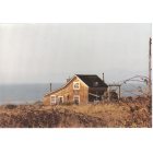
Westport: My House!
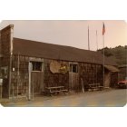
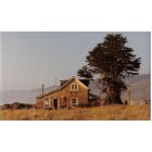
Westport: POST OFFICE
- add
your
Submit your own pictures of this place and show them to the world
- OSM Map
- General Map
- Google Map
- MSN Map

| Males: 2,535 | |
| Females: 2,080 |
| Median resident age: | 32.1 years |
| California median age: | 33.3 years |
Zip code: 95358
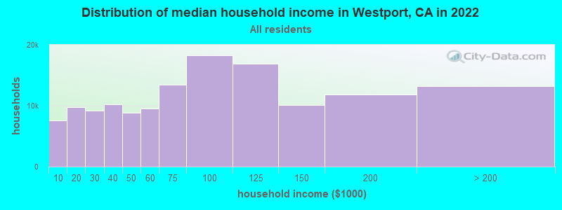
| Westport: | $59,591 |
| CA: | $91,551 |
Estimated per capita income in 2022: $25,144 (it was $13,224 in 2000)
Westport CCD income, earnings, and wages data
Estimated median house or condo value in 2022: $544,187 (it was $149,600 in 2000)
| Westport: | $544,187 |
| CA: | $715,900 |
Mean prices in 2022: all housing units: $478,509; detached houses: $501,424; townhouses or other attached units: $500,788; in 2-unit structures: $198,001; in 3-to-4-unit structures: $288,987; in 5-or-more-unit structures: $707,222; mobile homes: $105,610; occupied boats, rvs, vans, etc.: $87,411
Detailed information about poverty and poor residents in Westport, CA


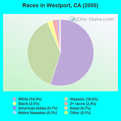
- 2,24954.9%White alone
- 1,58338.6%Hispanic
- 1012.5%Black alone
- 982.4%Two or more races
- 290.7%American Indian alone
- 290.7%Asian alone
- 50.1%Native Hawaiian and Other
Pacific Islander alone - 50.1%Other race alone
According to our research of California and other state lists, there was 1 registered sex offender living in Westport, California as of April 28, 2024.
The ratio of all residents to sex offenders in Westport is 4,615 to 1.
The ratio of registered sex offenders to all residents in this city is much lower than the state average.
 Recent articles from our blog. Our writers, many of them Ph.D. graduates or candidates, create easy-to-read articles on a wide variety of topics.
Current Local Time: PST time zone
Elevation: 115 feet
Land area: 60.9 square miles.
Population density: 76 people per square mile (very low).

| Westport CCD: | 0.5% ($711) |
| California: | 0.8% ($1,564) |
Nearest city with pop. 50,000+: Modesto, CA  (8.3 miles , pop. 188,856).
Nearest city with pop. 200,000+: Stockton, CA (32.2 miles , pop. 243,771).
Nearest city with pop. 1,000,000+: Los Angeles, CA (282.9 miles , pop. 3,694,820).
Nearest cities:
), ), ), ), ), ), )Latitude: 37.55 N, Longitude: 121.05 W

| Here: | 6.9% |
| California: | 5.1% |
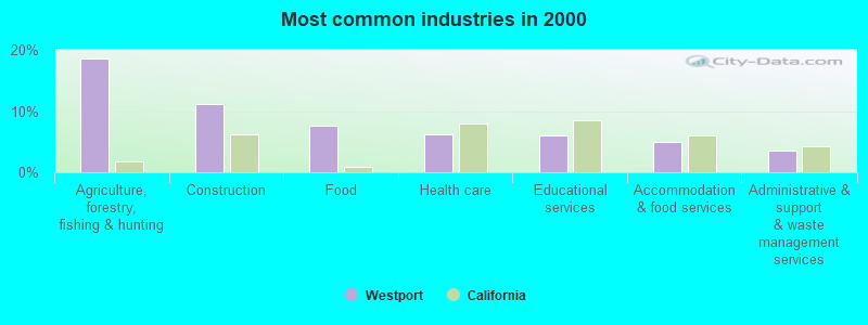
- Agriculture, forestry, fishing & hunting (18.6%)
- Construction (11.1%)
- Food (7.5%)
- Health care (6.2%)
- Educational services (6.1%)
- Accommodation & food services (5.0%)
- Administrative & support & waste management services (3.5%)
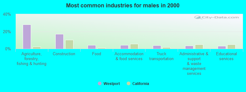
- Agriculture, forestry, fishing & hunting (28.1%)
- Construction (16.9%)
- Food (4.3%)
- Accommodation & food services (4.1%)
- Truck transportation (3.9%)
- Administrative & support & waste management services (3.5%)
- Educational services (3.3%)
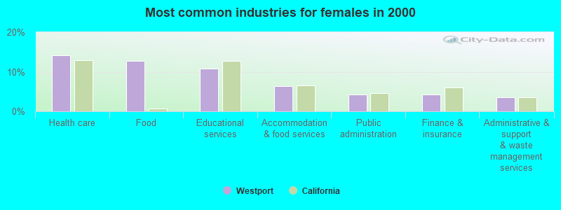
- Health care (14.2%)
- Food (12.8%)
- Educational services (10.8%)
- Accommodation & food services (6.4%)
- Public administration (4.2%)
- Finance & insurance (4.2%)
- Administrative & support & waste management services (3.6%)
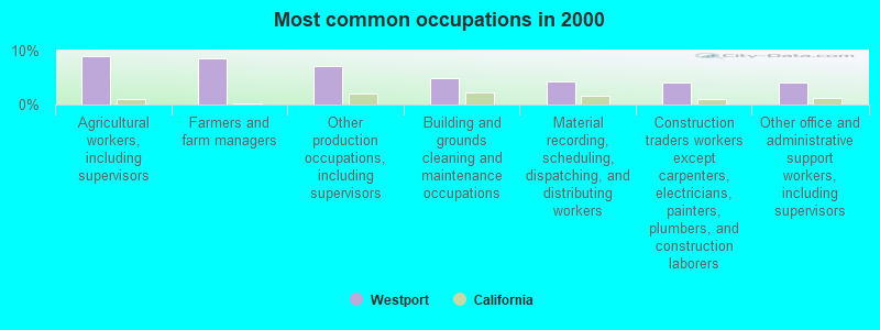
- Agricultural workers, including supervisors (9.0%)
- Farmers and farm managers (8.7%)
- Other production occupations, including supervisors (7.1%)
- Building and grounds cleaning and maintenance occupations (4.8%)
- Material recording, scheduling, dispatching, and distributing workers (4.4%)
- Construction traders workers except carpenters, electricians, painters, plumbers, and construction laborers (4.1%)
- Other office and administrative support workers, including supervisors (4.0%)
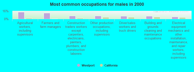
- Agricultural workers, including supervisors (13.9%)
- Farmers and farm managers (12.2%)
- Construction traders workers except carpenters, electricians, painters, plumbers, and construction laborers (6.1%)
- Other production occupations, including supervisors (6.1%)
- Driver/sales workers and truck drivers (6.0%)
- Building and grounds cleaning and maintenance occupations (5.8%)
- Electrical equipment mechanics and other installation, maintenance, and repair workers, including supervisors (4.5%)
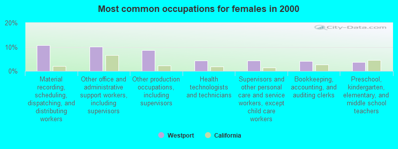
- Material recording, scheduling, dispatching, and distributing workers (10.6%)
- Other office and administrative support workers, including supervisors (10.0%)
- Other production occupations, including supervisors (8.6%)
- Health technologists and technicians (4.4%)
- Supervisors and other personal care and service workers, except child care workers (4.4%)
- Bookkeeping, accounting, and auditing clerks (4.2%)
- Preschool, kindergarten, elementary, and middle school teachers (3.8%)
Average climate in Westport, California
Based on data reported by over 4,000 weather stations


(lower is better)
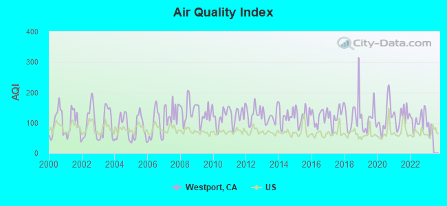
Air Quality Index (AQI) level in 2022 was 110. This is significantly worse than average.
| City: | 110 |
| U.S.: | 73 |
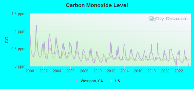
Carbon Monoxide (CO) [ppm] level in 2022 was 0.234. This is about average. Closest monitor was 6.8 miles away from the city center.
| City: | 0.234 |
| U.S.: | 0.251 |
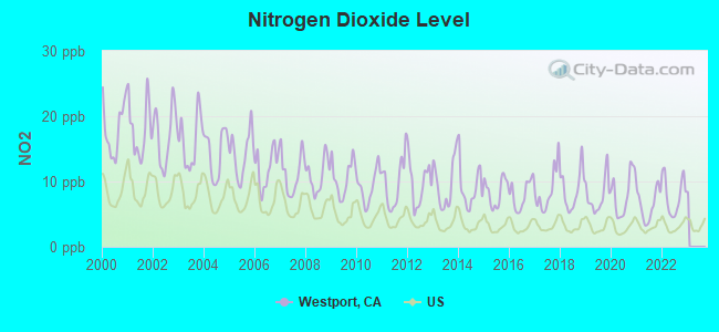
Nitrogen Dioxide (NO2) [ppb] level in 2022 was 7.86. This is significantly worse than average. Closest monitor was 6.8 miles away from the city center.
| City: | 7.86 |
| U.S.: | 5.11 |
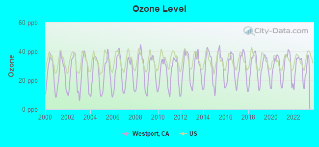
Ozone [ppb] level in 2022 was 28.0. This is about average. Closest monitor was 6.8 miles away from the city center.
| City: | 28.0 |
| U.S.: | 33.3 |
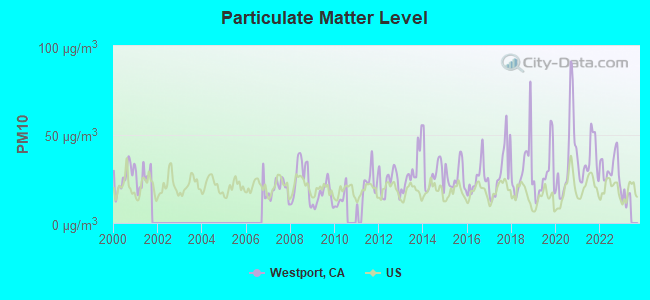
Particulate Matter (PM10) [µg/m3] level in 2022 was 31.1. This is significantly worse than average. Closest monitor was 7.0 miles away from the city center.
| City: | 31.1 |
| U.S.: | 19.2 |
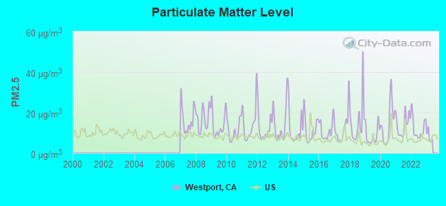
Particulate Matter (PM2.5) [µg/m3] level in 2022 was 12.1. This is significantly worse than average. Closest monitor was 7.1 miles away from the city center.
| City: | 12.1 |
| U.S.: | 8.1 |
Earthquake activity:
Westport-area historical earthquake activity is significantly above California state average. It is 8121% greater than the overall U.S. average.On 4/18/1906 at 13:12:21, a magnitude 7.9 (7.9 UK, Class: Major, Intensity: VIII - XII) earthquake occurred 110.8 miles away from Westport center, causing $524,000,000 total damage
On 10/18/1989 at 00:04:15, a magnitude 7.1 (6.5 MB, 7.1 MS, 6.9 MW, 7.0 ML) earthquake occurred 49.8 miles away from the city center, causing 62 deaths (62 shaking deaths) and 3757 injuries, causing $1,305,032,704 total damage
On 7/21/1952 at 11:52:14, a magnitude 7.7 (7.7 UK) earthquake occurred 210.4 miles away from the city center, causing $50,000,000 total damage
On 11/4/1927 at 13:51:53, a magnitude 7.5 (7.5 UK) earthquake occurred 182.4 miles away from the city center
On 12/21/1932 at 06:10:09, a magnitude 7.2 (7.2 UK) earthquake occurred 174.9 miles away from Westport center
On 10/3/1915 at 06:52:48, a magnitude 7.6 (7.6 UK) earthquake occurred 279.3 miles away from Westport center
Magnitude types: body-wave magnitude (MB), local magnitude (ML), surface-wave magnitude (MS), moment magnitude (MW)
Natural disasters:
The number of natural disasters in Stanislaus County (13) is near the US average (15).Major Disasters (Presidential) Declared: 8
Emergencies Declared: 2
Causes of natural disasters: Floods: 8, Storms: 4, Winter Storms: 3, Landslides: 2, Mudslides: 2, Drought: 1, Fire: 1, Freeze: 1, Heavy Rain: 1, Hurricane: 1, Tornado: 1, Other: 1 (Note: some incidents may be assigned to more than one category).
Hospitals and medical centers near Westport:
- HA-LE ALOHA CONVALESCENT HOSPITAL (Nursing Home, about 7 miles away; CERES, CA)
- RENO AVE CONV HOSP (Nursing Home, about 7 miles away; MODESTO, CA)
- SATELLITE DIALYSIS - CENTRAL MODESTO (Dialysis Facility, about 7 miles away; MODESTO, CA)
- GLOBAL HEALTHCARE SERVICES, LLC (Home Health Center, about 8 miles away; MODESTO, CA)
- KINDRED HOSPITAL MODESTO (Hospital, about 8 miles away; MODESTO, CA)
- MODESTO REHABILITATION HOSPITAL (Nursing Home, about 8 miles away; MODESTO, CA)
- CERES DIALYSIS CENTER (Dialysis Facility, about 8 miles away; CERES, CA)
Amtrak stations near Westport:
- 12 miles: MODESTO (1700 HELD DRIVE) . Services: ticket office, fully wheelchair accessible, enclosed waiting area, public restrooms, public payphones, vending machines, free short-term parking, free long-term parking, call for car rental service, call for taxi service, public transit connection.
- 15 miles: TURLOCK-DENAIR (DENAIR, SANTA FE ST. AT ELM ST.) . Services: fully wheelchair accessible, public payphones, vending machines, free short-term parking, free long-term parking, call for taxi service.
Colleges/universities with over 2000 students nearest to Westport:
- Modesto Junior College (about 8 miles; Modesto, CA; Full-time enrollment: 10,635)
- California State University-Stanislaus (about 12 miles; Turlock, CA; FT enrollment: 7,054)
- University of the Pacific (about 33 miles; Stockton, CA; FT enrollment: 4,999)
- San Joaquin Delta College (about 34 miles; Stockton, CA; FT enrollment: 12,167)
- Merced College (about 36 miles; Merced, CA; FT enrollment: 6,973)
- University of California-Merced (about 37 miles; Merced, CA; FT enrollment: 5,981)
- Las Positas College (about 43 miles; Livermore, CA; FT enrollment: 5,112)
Points of interest:
Notable locations in Westport: Alamo Dairy (A), Mendes Dairy (B), Clarot Farms (C), Edelweiss Dairy (D), Hidden Valley Dairy (E), Amorim Dairy (F), Lamb Farms (G), Tsai Farms (H), Bonzi Sanitation Landfill (I), Westport Fire Protection District (J). Display/hide their locations on the map
Reservoir: Brush Lake (A). Display/hide its location on the map
Parks in Westport include: Riverdale Park (1), Adamsville State Historic Landmark (2), Fairview Park (3), Laird Park (4). Display/hide their locations on the map
| This place: | 3.2 people |
| California: | 2.9 people |
| This place: | 74.6% |
| Whole state: | 68.7% |
| This place: | 9.3% |
| Whole state: | 7.2% |
Likely homosexual households (counted as self-reported same-sex unmarried-partner households)
- Lesbian couples: 0.5% of all households
- Gay men: 0.3% of all households
| This place: | 25.0% |
| Whole state: | 14.2% |
| This place: | 11.0% |
| Whole state: | 6.3% |
3 people in other noninstitutional facilities in 2010
People in group quarters in Westport in 2000:
- 250 people in other types of correctional institutions
- 68 people in other noninstitutional group quarters
- 20 people in other nonhousehold living situations
- 7 people in agriculture workers' dormitories on farms
- 5 people in other group homes
For population 15 years and over in Westport:
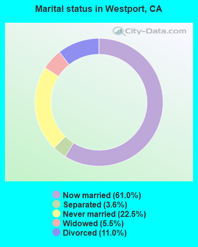
- Never married: 22.5%
- Now married: 61.0%
- Separated: 3.6%
- Widowed: 5.5%
- Divorced: 11.0%
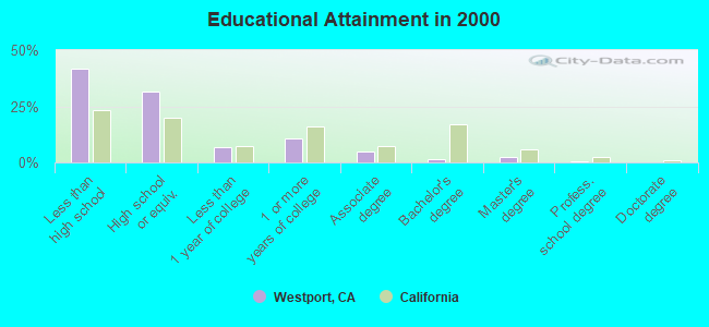
For population 25 years and over in Westport:
- High school or higher: 58.2%
- Bachelor's degree or higher: 4.6%
- Graduate or professional degree: 3.0%
- Unemployed: 14.9%
- Mean travel time to work (commute): 28.1 minutes
| Here: | 19.9 |
| California average: | 16.1 |
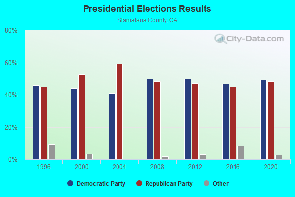
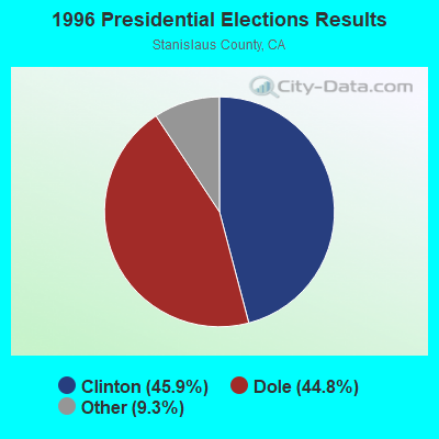
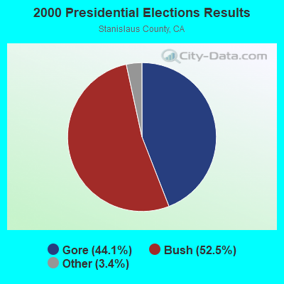
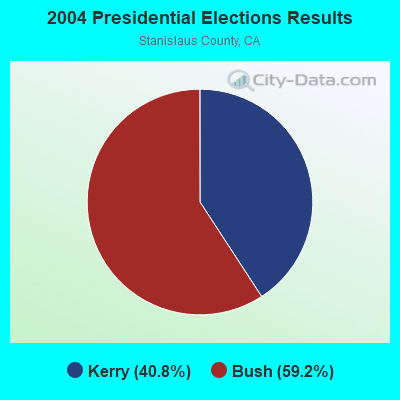
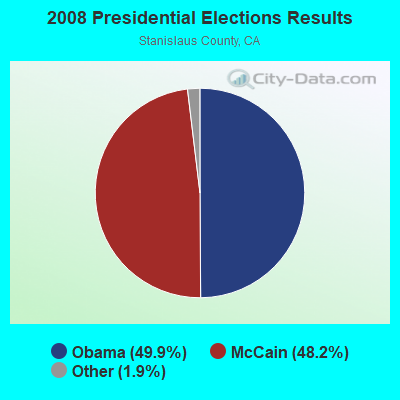
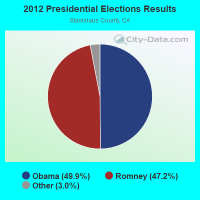
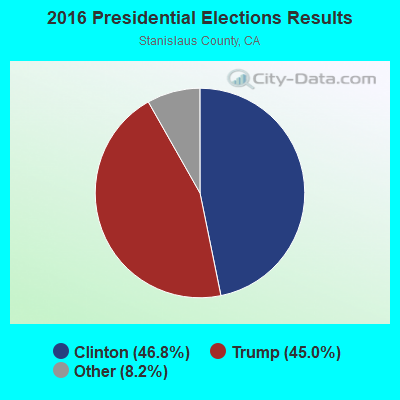
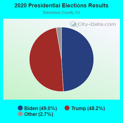
Graphs represent county-level data. Detailed 2008 Election Results
Religion statistics for Westport, CA (based on Stanislaus County data)
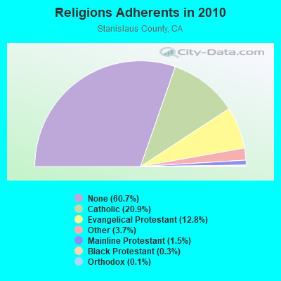
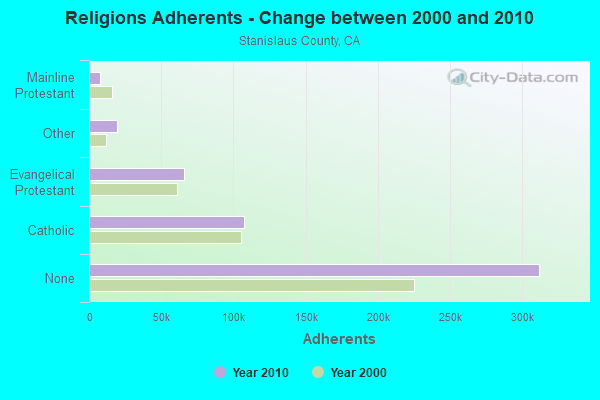
| Religion | Adherents | Congregations |
|---|---|---|
| Catholic | 107,529 | 18 |
| Evangelical Protestant | 65,976 | 268 |
| Other | 19,198 | 59 |
| Mainline Protestant | 7,730 | 34 |
| Black Protestant | 1,312 | 8 |
| Orthodox | 625 | 2 |
| None | 312,083 | - |
Food Environment Statistics:
| Stanislaus County: | 2.61 / 10,000 pop. |
| State: | 2.14 / 10,000 pop. |
| Here: | 0.04 / 10,000 pop. |
| State: | 0.04 / 10,000 pop. |
| This county: | 0.65 / 10,000 pop. |
| California: | 0.62 / 10,000 pop. |
| Stanislaus County: | 2.22 / 10,000 pop. |
| California: | 1.49 / 10,000 pop. |
| Here: | 5.54 / 10,000 pop. |
| California: | 7.42 / 10,000 pop. |
| Stanislaus County: | 8.9% |
| California: | 7.3% |
| Stanislaus County: | 28.0% |
| California: | 21.3% |
| Here: | 17.1% |
| State: | 17.9% |
5.00% of this county's 2021 resident taxpayers lived in other counties in 2020 ($56,165 average adjusted gross income)
| Here: | 5.00% |
| California average: | 5.19% |
0.01% of residents moved from foreign countries ($94 average AGI)
Stanislaus County: 0.01% California average: 0.03%
Top counties from which taxpayers relocated into this county between 2020 and 2021:
| from San Joaquin County, CA | |
| from Alameda County, CA | |
| from Santa Clara County, CA |
5.39% of this county's 2020 resident taxpayers moved to other counties in 2021 ($61,321 average adjusted gross income)
| Here: | 5.39% |
| California average: | 6.14% |
0.01% of residents moved to foreign countries ($87 average AGI)
Stanislaus County: 0.01% California average: 0.02%
Top counties to which taxpayers relocated from this county between 2020 and 2021:
| to San Joaquin County, CA | |
| to Merced County, CA | |
| to Sacramento County, CA |
Strongest AM radio stations in Westport:
- KCBC (770 AM; 50 kW; RIVERBANK, CA; Owner: KIERTRON, INC.)
- KFIV (1360 AM; 4 kW; MODESTO, CA; Owner: CAPSTAR TX LIMITED PARTNERSHIP)
- KLOK (1170 AM; 50 kW; SAN JOSE, CA; Owner: ENTRAVISION HOLDINGS, LLC)
- KGO (810 AM; 50 kW; SAN FRANCISCO, CA; Owner: KGO-AM RADIO, INC.)
- KNBR (680 AM; 50 kW; SAN FRANCISCO, CA; Owner: KNBR LICO, INC.)
- KTCT (1050 AM; 50 kW; SAN MATEO, CA; Owner: SUSQUEHANNA RADIO CORP.)
- KHTK (1140 AM; 50 kW; SACRAMENTO, CA; Owner: INFINITY RADIO SUBSIDIARY OPERATIONS INC.)
- KFAX (1100 AM; 50 kW; SAN FRANCISCO, CA; Owner: GOLDEN GATE BROADCASTING CO, INC.)
- KTRB (860 AM; 50 kW; MODESTO, CA; Owner: PAPPAS RADIO OF CALIFORNIA, A CALIFORNIA LIMITED PARTNERSHIP)
- KLOC (1390 AM; 5 kW; TURLOCK, CA)
- KVIN (920 AM; 2 kW; CERES, CA; Owner: THRESHOLD COMMUNICATIONS)
- KSTE (650 AM; 25 kW; RANCHO CORDOVA, CA; Owner: AMFM RADIO LICENSES, L.L.C.)
- KESP (970 AM; 1 kW; MODESTO, CA; Owner: CITADEL BROADCASTING COMPANY)
Strongest FM radio stations in Westport:
- K238AC (95.5 FM; SALIDA, CA; Owner: FAMILY STATIONS, INC.)
- KOSO (93.1 FM; PATTERSON, CA; Owner: CAPSTAR TX LIMITED PARTNERSHIP)
- KUOP (91.3 FM; STOCKTON, CA; Owner: UNIVERSITY OF THE PACIFIC)
- KEJC (93.9 FM; MODESTO, CA; Owner: MODESTO COMMUNICATIONS CORPORATION)
- KTSE-FM (97.1 FM; PATTERSON, CA; Owner: ENTRAVISION HOLDINGS, LLC)
- KHOP (95.1 FM; OAKDALE, CA; Owner: CITADEL BROADCASTING COMPANY)
- KKSF-FM1 (103.7 FM; PLEASANTON, ETC., CA; Owner: AMFM RADIO LICENSES, L.L.C.)
- KHTN (104.7 FM; LOS BANOS, CA; Owner: BUCKLEY COMMUNICATIONS, INC.)
- KJOY (99.3 FM; STOCKTON, CA; Owner: CITADEL BROADCASTING COMPANY)
- KBAA (94.5 FM; GILROY, CA; Owner: INFINITY RADIO OPERATIONS INC.)
- KFRC-FM3 (99.7 FM; WALNUT CREEK, CA; Owner: INFINITY KFRC-FM, INC.)
- KZBR-FM1 (95.7 FM; WALNUT CREEK, CA; Owner: BONNEVILLE HOLDING COMPANY)
- KBLX-FM2 (102.9 FM; PLEASANTON, CA; Owner: ICBC BROADCAST HOLDINGS -CA, INC.)
- KSOL-FM3 (98.9 FM; PLEASANTON, CA; Owner: TMS LICENSE CALIFORNIA, INC)
- KWNN (98.3 FM; TURLOCK, CA; Owner: SILVERADO BROADCASTING COMPANY)
- KISQ-FM3 (98.1 FM; CONCORD, CA; Owner: AMFM RADIO LICENSES, L.L.C.)
- KMEL-FM1 (106.1 FM; CONCORD, CA; Owner: AMFM RADIO LICENSES, L.L.C.)
- KSQL (99.1 FM; SANTA CRUZ, CA; Owner: TMS LICENSE CALIFORNIA, INC)
- KMRQ (96.7 FM; MANTECA, CA; Owner: CAPSTAR TX LIMITED PARTNERSHIP)
- KKUP (91.5 FM; CUPERTINO, CA; Owner: ASSURANCE SCIENCES FOUNDATION)
TV broadcast stations around Westport:
- KBSV (Channel 23; CERES, CA; Owner: BET-NAHRAIN, INC.)
- KACA-LP (Channel 61; MODESTO, CA; Owner: WORD OF GOD FELLOWSHIP, INC.)
- KOVR (Channel 13; STOCKTON, CA; Owner: SCI - SACRAMENTO LICENSEE, LLC)
- KXTV (Channel 10; SACRAMENTO, CA; Owner: KXTV, INC.)
- KUVS (Channel 19; MODESTO, CA; Owner: KUVS LICENSE PARTNERSHIP, G.P.)
- KCRA-TV (Channel 3; SACRAMENTO, CA; Owner: KCRA HEARST-ARGYLE TELEVISION, INC.)
- KSPX (Channel 29; SACRAMENTO, CA; Owner: PAXSON SACRAMENTO LICENSE, INC.)
- KQCA (Channel 58; STOCKTON, CA; Owner: KCRA HEARST-ARGYLE TELEVISION, INC.)
- KTXL (Channel 40; SACRAMENTO, CA; Owner: CHANNEL 40, INC.)
- KMAX-TV (Channel 31; SACRAMENTO, CA; Owner: UPN STATIONS GROUP INC.)
- KVIE (Channel 6; SACRAMENTO, CA; Owner: KVIE, INC.)
FCC Registered Private Land Mobile Towers:
1- Hwy 1 And Branscomb Rd (Lat: 39.662667 Lon: -123.784194), Structure height: 18 m, Call Sign: WNZH446, Licensee ID: L00001014,
Assigned Frequencies: 856.112 MHz, 857.112 MHz, 858.112 MHz, 859.112 MHz, 860.112 MHz, Grant Date: 04/03/2007, Expiration Date: 05/07/2017, Cancellation Date: 06/27/2012, Certifier: David Haller, Registrant: Nextel Of California, Inc.
FCC Registered Broadcast Land Mobile Towers:
1- 40500 N Hwy 1 (Lat: 39.678500 Lon: -123.789333), Type: Pipe, Structure height: 3.7 m, Overall height: 7.6 m, Call Sign: WPUA666,
Assigned Frequencies: 151.475 MHz, 158.865 MHz, Grant Date: 11/02/2021, Expiration Date: 01/24/2032, Certifier: Glen S Nash, Registrant: State Of California, 601 Sequoia Pacific Blvd, Sacramento, CA 95811-0231, Phone: (916) 894-5102, Fax: (916) 894-5392, Email:
FCC Registered Microwave Towers:
1- WESTPORT, Hwy 101 N Of (Lat: 39.641528 Lon: -123.776389), Overall height: 50.3 m, Call Sign: WPJB383,
Assigned Frequencies: 10618.1 MHz, Grant Date: 10/23/1995, Expiration Date: 02/01/2001, Cancellation Date: 10/16/1996, Registrant: California Rsa #9 Inc, 8410 W Bryn Mawr Ave Ste 700, Chicago, IL 60631
FCC Registered Amateur Radio Licenses:
1- Call Sign: WB6GGR, Grant Date: 11/08/1988, Expiration Date: 11/08/1998, Cancellation Date: 11/09/2000, Registrant: Milton R Kerchenko, 37033 Omega Dr Box 74, Westport, CA 95488
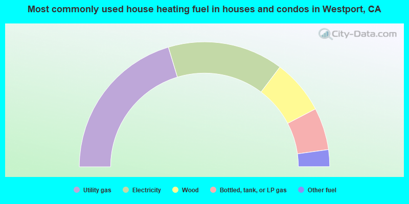
- 40.7%Utility gas
- 29.9%Electricity
- 14.1%Wood
- 10.9%Bottled, tank, or LP gas
- 4.4%Other fuel
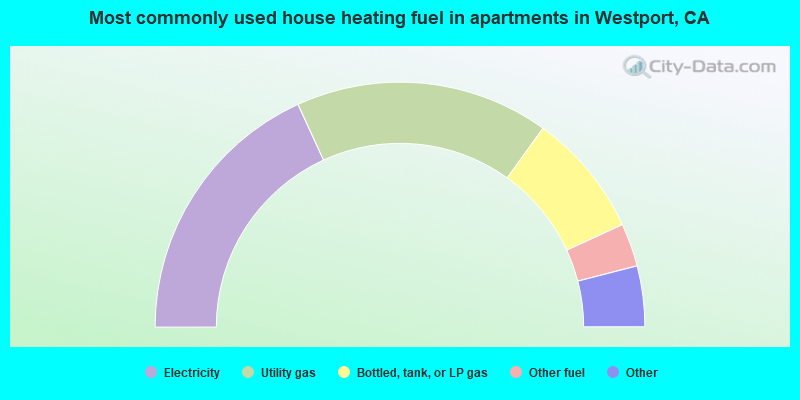
- 36.3%Electricity
- 33.5%Utility gas
- 16.4%Bottled, tank, or LP gas
- 5.7%Other fuel
- 3.1%No fuel used
- 2.7%Fuel oil, kerosene, etc.
- 2.3%Wood
Westport compared to California state average:
- Median household income below state average.
- Black race population percentage below state average.
- Foreign-born population percentage significantly below state average.
- Length of stay since moving in significantly above state average.
- Number of rooms per house significantly below state average.
- House age significantly below state average.
- Institutionalized population percentage above state average.
- Number of college students below state average.
- Percentage of population with a bachelor's degree or higher significantly below state average.
Westport on our top lists:
- #23 on the list of "Top 101 cities with the largest percentage of people in other types of correctional institutions (population 1,000+)"
- #69 (95358) on the list of "Top 101 zip codes with the largest percentage of Swiss first ancestries (pop 5,000+)"
- #86 (95358) on the list of "Top 101 zip codes with the largest percentage of Portuguese first ancestries (pop 5,000+)"
- #24 on the list of "Top 101 counties with the highest Particulate Matter (PM2.5) Annual air pollution readings in 2012 (µg/m3)"
- #26 on the list of "Top 101 counties with the highest Nitrogen Dioxide air pollution readings in 2012 (ppm)"
- #28 on the list of "Top 101 counties with the highest ground withdrawal of fresh water for public supply"
- #36 on the list of "Top 101 counties with the highest Particulate Matter (PM10) Annual air pollution readings in 2012 (µg/m3)"
- #56 on the list of "Top 101 counties with the lowest percentage of residents relocating from foreign countries between 2010 and 2011 (pop. 50,000+)"

|
|
Total of 9 patent applications in 2008-2024.