Please register to participate in our discussions with 2 million other members - it's free and quick! Some forums can only be seen by registered members. After you create your account, you'll be able to customize options and access all our 15,000 new posts/day with fewer ads.
Watches and Warning. Looks like a winter map. I knew this pattern was "starting" to look interesting back in August. Finally took place in September.
Posted October 15th
Quote:
Originally Posted by Cambium
Slowly but surely. After the 24th I believe we start to see the northern Branch dive down again and winter will start to show up again.
Record snowstorm NorEaster. Great Lake Snows. Upper mid West snows, New England Snows. Below normal temps. Record CA mountain snows, More snows tonight in NorthEast all happened after end of October.
It wasnt just a guess...it was the pattern I saw. Last year I was talking about the warming coming more often. Trend is your friend until it breaks up. This above normal warmup is temporary, maybe couple days worth, then to seasonable.. We dive back into winter after mid December.( after the 10th).
Estonia is almost at 60North. Europe isn't that mild.
I think Hiromat lives in Tallin, which is near water. Tallin's winter lows are slightly warmer than me, 17° further north. I can't remember ever having a below zero °F in early December, let alone -13°F, so yes that sounds extremely cold for the location, unless Estonia is much more variable than my location, which highly doubt. Most likely the reverse is true.
Your average highs are warmer. As i've said before, no point in comparing USA and Europe because we are different. We have smaller Diurnal range.
I would go so far to say he has a colder winter than you overall, because your days are warmer.
It would be easy to get a low of 0f in his location because he has shorter daylight.
For cold lovers, places like Stockholm, Helsinki, Tallinn and Oslo have one important thing over places like western Massachusetts.. the ability to hold onto snow for months at a time. Stockholm is pretty balmy in winter for the latitude, but I believe it had snow cover from early November until late March / early April in the winter season of 2010 / 2011 with no thaws at all.
Your average highs are warmer. As i've said before, no point in comparing USA and Europe because we are different. We have smaller Diurnal range.
I would go so far to say he has a colder winter than you overall, because your days are warmer.
It would be easy to get a low of 0f in his location because he has shorter daylight.
I'm comparing low temperatures, not highs or overall. Hiromat was talking about a low temperature. I don't think my location is less prone to cold night temperatures, in fact my average low is a bit lower. Not sure which location would be better for below 0°F lows.
NWS Mt Holly Winter 2012-13 Analog years. Good info here. PDF file. Looks like a blend, I havent read it completely but looks like some above normals, normals, and below normals on the blended maps. Here's the years they went with.
MUCH CONFIDENCE BEYOND USING WHAT WE HAVE ALREADY BEEN DOING FOR
SEVERAL YEARS: LOOKING AT THE LOCAL OCTOBER AND NOVEMBER
TEMPERATURES. IN A CIRCUITOUS ROUTE (ARRIVING WITH THE SAME
OUTCOME?), THE SNOW COVER INFLUENCES THE PATTERNS WHICH IN TURN
INFLUENCES THE TEMPERATURES. WE HAD A WARM OCTOBER AND FOR THE
FIRST TIME SINCE 1996 WE BELIEVE WILL HAVE A COLD (LOWEST THIRD)
NOVEMBER. THIS TOP THIRD, BOTTOM THIRD COMBO IS NOT COMMON AT ALL
IN ANY ENSO REGIME. SO MUCH SO, FOR OUR ANALOG SERIES TO GET SIX
PAST SEASONS, WE HAD TO INCLUDE A COUPLE OF WEAK EL NINO WINTERS
AND ONE ENSO NEUTRAL NEGATIVE WINTER. ALL HAD WARM OCTOBERS AND
COLDER THAN CURRENT NORMAL NOVEMBERS TO FIT THE TEMPERATURE
SEQUENCE. ONLY 1959-60 HAD A LOWEST THIRD (COLD) NOVEMBER. AFTER
ALL OF THE EURASIAN SNOW COVER DISCUSSION IT IS IRONIC THAT ALL OF
THESE ANALOGS OCCURRED PRIOR TO SATELLITE DATA BEING AVAILABLE TO
GATHER THESE STATISTICS. SO HERE ARE OUR CHEAPER BY THE HALF DOZEN
ANALOGS FOR THIS UPCOMING WINTER FOR PHILADELPHIA. THEIR MILEAGE
MAY VARY:
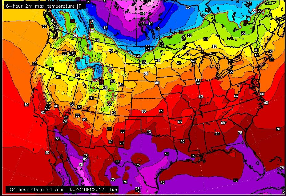
Quick look at the GFS max temps. This was the warmest time frame I can find as a whole. Monday afternoon.
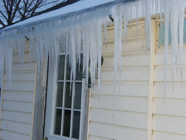
That looks about right for our region. They are calling for low 50's Sun and Mon here before it begins dropping back to 30's for day and 20's at night. What snow we have on the ground will disappear quick those two days. The current melting we have going on is making for some decent icicle formation. Now if we can just keep the wind from ripping shingles and siding off the house.
I think Hiromat lives in Tallin, which is near water. Tallin's winter lows are slightly warmer than me, 17° further north. I can't remember ever having a below zero °F in early December, let alone -13°F, so yes that sounds extremely cold for the location, unless Estonia is much more variable than my location, which highly doubt. Most likely the reverse is true.
Cold waves below 0°F are nothing surprising from early December to late March. Our proximity to Siberia and Lapland means frigid air masses can spill over at any time, often staying in place for weeks.
This forecast is from this February:
These temperatures lasted for three weeks and it dropped to -39°C in other parts of the country. The average temperature of February is a mere -7°C. Dunno is right about the snow as well. There's usually nearly a meter of it by mid-March and that's lying snow, not precipitation. Even now after two days of snowing there's more than 30 cm and winter has barely begun. Ice roads to islands can be open from mid-January to early April. Some winters are of course milder but on average it's the longest and strongest season. The climate is on the border of temperate and sub-Arctic.
Last edited by Hiromant; 11-30-2012 at 11:45 AM..
Please register to post and access all features of our very popular forum. It is free and quick. Over $68,000 in prizes has already been given out to active posters on our forum. Additional giveaways are planned.
Detailed information about all U.S. cities, counties, and zip codes on our site: City-data.com.

 Please register to participate in our discussions with 2 million other members - it's free and quick! Some forums can only be seen by registered members. After you create your account, you'll be able to customize options and access all our 15,000 new posts/day with fewer ads.


 Trend is your friend until it breaks up. This above normal warmup is temporary, maybe couple days worth, then to seasonable.. We dive back into winter after mid December.( after the 10th).