Mansfield, Massachusetts
Submit your own pictures of this town and show them to the world
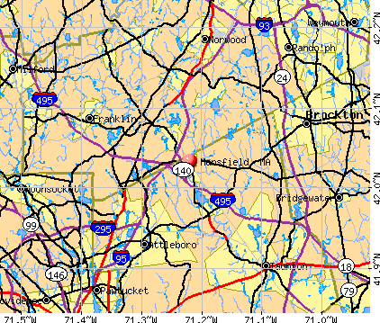
- OSM Map
- General Map
- Google Map
- MSN Map
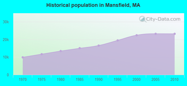
Population change since 2000: +3.4%
 |
| Males: 11,517 | |
| Females: 11,667 |
| Median resident age: | 38.6 years |
| Massachusetts median age: | 39.2 years |
Zip codes: 02048.
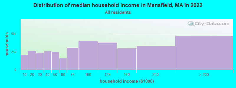
| Mansfield: | $125,478 |
| MA: | $94,488 |
Estimated per capita income in 2022: $55,955 (it was $27,441 in 2000)
Mansfield town income, earnings, and wages data
Estimated median house or condo value in 2022: $634,638 (it was $216,100 in 2000)
| Mansfield: | $634,638 |
| MA: | $534,700 |
Mean prices in 2022: all housing units: $449,660; detached houses: $484,124; townhouses or other attached units: $382,766; in 2-unit structures: $322,469; in 3-to-4-unit structures: $355,875; in 5-or-more-unit structures: $269,714; mobile homes: $156,871; occupied boats, rvs, vans, etc.: $49,834
Detailed information about poverty and poor residents in Mansfield, MA


- 20,89990.1%White alone
- 7913.4%Asian alone
- 6012.6%Black alone
- 4872.1%Hispanic
- 2831.2%Two or more races
- 590.3%American Indian alone
- 600.3%Other race alone
- 40.02%Native Hawaiian and Other
Pacific Islander alone
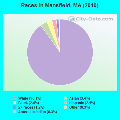
Races in Mansfield detailed stats: ancestries, foreign born residents, place of birth
According to our research of Massachusetts and other state lists, there were 2 registered sex offenders living in Mansfield, Massachusetts as of May 02, 2024.
The ratio of all residents to sex offenders in Mansfield is 11,592 to 1.
The ratio of registered sex offenders to all residents in this city is much lower than the state average.
Type |
2009 |
2010 |
2011 |
2012 |
2013 |
2014 |
2015 |
2016 |
2017 |
2018 |
2019 |
2020 |
2021 |
2022 |
|---|---|---|---|---|---|---|---|---|---|---|---|---|---|---|
| Murders (per 100,000) | 1 (4.3) | 0 (0.0) | 2 (8.6) | 0 (0.0) | 0 (0.0) | 0 (0.0) | 0 (0.0) | 0 (0.0) | 0 (0.0) | 0 (0.0) | 0 (0.0) | 0 (0.0) | 0 (0.0) | 0 (0.0) |
| Rapes (per 100,000) | 2 (8.6) | 7 (30.2) | 9 (38.6) | 3 (12.8) | 8 (34.0) | 11 (46.4) | 5 (21.1) | 9 (38.0) | 8 (33.5) | 6 (24.9) | 11 (45.9) | 3 (12.3) | 7 (28.1) | 4 (16.7) |
| Robberies (per 100,000) | 7 (30.0) | 5 (21.6) | 2 (8.6) | 8 (34.2) | 3 (12.7) | 4 (16.9) | 1 (4.2) | 3 (12.7) | 3 (12.6) | 1 (4.2) | 5 (20.8) | 3 (12.3) | 3 (12.1) | 4 (16.7) |
| Assaults (per 100,000) | 57 (244.1) | 36 (155.3) | 33 (141.5) | 41 (175.1) | 37 (157.1) | 27 (113.8) | 54 (227.8) | 27 (114.0) | 29 (121.6) | 27 (112.3) | 49 (204.3) | 29 (118.4) | 28 (112.5) | 21 (87.7) |
| Burglaries (per 100,000) | 75 (321.2) | 126 (543.5) | 149 (638.8) | 202 (862.5) | 144 (611.4) | 64 (269.7) | 55 (232.0) | 42 (177.4) | 31 (130.0) | 35 (145.5) | 15 (62.5) | 11 (44.9) | 17 (68.3) | 11 (46.0) |
| Thefts (per 100,000) | 215 (920.9) | 245 (1,057) | 224 (960.3) | 229 (977.8) | 196 (832.2) | 174 (733.3) | 179 (755.1) | 149 (629.2) | 209 (876.4) | 160 (665.3) | 147 (612.8) | 84 (343.1) | 121 (486.3) | 143 (597.5) |
| Auto thefts (per 100,000) | 21 (89.9) | 18 (77.6) | 22 (94.3) | 19 (81.1) | 12 (51.0) | 7 (29.5) | 11 (46.4) | 16 (67.6) | 9 (37.7) | 11 (45.7) | 8 (33.4) | 3 (12.3) | 13 (52.3) | 6 (25.1) |
| Arson (per 100,000) | 0 (0.0) | 3 (12.9) | 1 (4.3) | 1 (4.3) | 3 (12.7) | 2 (8.4) | 2 (8.4) | 3 (12.7) | 0 (0.0) | 0 (0.0) | 0 (0.0) | 1 (4.1) | 0 (0.0) | 1 (4.2) |
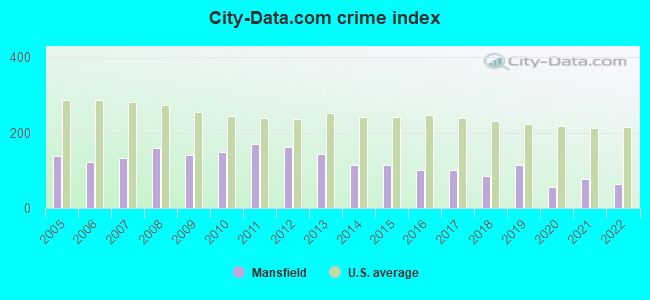
| City-Data.com crime index | 139.8 | 148.2 | 169.6 | 161.5 | 142.6 | 115.5 | 113.9 | 100.0 | 102.1 | 84.1 | 115.4 | 55.0 | 77.0 | 65.1 |
The City-Data.com crime index weighs serious crimes and violent crimes more heavily. Higher means more crime, U.S. average is 246.1. It adjusts for the number of visitors and daily workers commuting into cities.
Crime rate in Mansfield detailed stats: murders, rapes, robberies, assaults, burglaries, thefts, arson
Full-time law enforcement employees in 2021, including police officers: 48 (38 officers - 34 male; 4 female).
| Officers per 1,000 residents here: | 1.53 |
| Massachusetts average: | 2.53 |
 Recent articles from our blog. Our writers, many of them Ph.D. graduates or candidates, create easy-to-read articles on a wide variety of topics.


Latest news from Mansfield, MA collected exclusively by city-data.com from local newspapers, TV, and radio stations
Ancestries: Irish (32.4%), Italian (20.3%), English (14.5%), German (9.6%), French (7.4%), Polish (5.6%).
Current Local Time: EST time zone
Incorporated in 1775
Elevation: 160 feet
Land area: 20.5 square miles.
Population density: 1,133 people per square mile (low).
894 residents are foreign born (1.7% Europe, 1.3% Asia, 0.5% Latin America).
| This town: | 4.0% |
| Massachusetts: | 12.2% |
| Mansfield town: | 1.4% ($3,064) |
| Massachusetts: | 1.3% ($2,336) |
Nearest city with pop. 50,000+: Taunton, MA  (10.4 miles , pop. 55,976).
Nearest city with pop. 200,000+: Boston, MA (21.9 miles , pop. 589,141).
Nearest city with pop. 1,000,000+: Bronx, NY (159.8 miles , pop. 1,332,650).
Nearest cities:
), ), ), ), )Latitude: 42.02 N, Longitude: 71.22 W
Area codes: 508, 774

Mansfield, Massachusetts accommodation & food services, waste management - Economy and Business Data
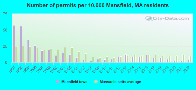
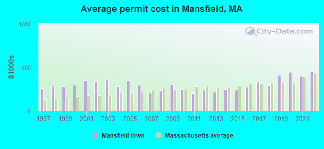
Single-family new house construction building permits:
- 2022: 8 buildings, average cost: $451,600
- 2021: 6 buildings, average cost: $403,400
- 2020: 5 buildings, average cost: $450,000
- 2019: 11 buildings, average cost: $413,600
- 2018: 16 buildings, average cost: $293,200
- 2017: 16 buildings, average cost: $331,000
- 2016: 26 buildings, average cost: $273,300
- 2015: 20 buildings, average cost: $237,700
- 2014: 20 buildings, average cost: $247,800
- 2013: 28 buildings, average cost: $220,200
- 2012: 20 buildings, average cost: $240,800
- 2011: 11 buildings, average cost: $198,700
- 2010: 10 buildings, average cost: $247,500
- 2009: 11 buildings, average cost: $306,300
- 2008: 5 buildings, average cost: $235,000
- 2007: 9 buildings, average cost: $206,300
- 2006: 18 buildings, average cost: $300,300
- 2005: 28 buildings, average cost: $346,700
- 2004: 33 buildings, average cost: $279,700
- 2003: 25 buildings, average cost: $363,800
- 2002: 44 buildings, average cost: $337,200
- 2001: 42 buildings, average cost: $352,400
- 2000: 59 buildings, average cost: $297,600
- 1999: 79 buildings, average cost: $279,400
- 1998: 126 buildings, average cost: $287,300
- 1997: 129 buildings, average cost: $257,500
| Here: | 3.1% |
| Massachusetts: | 3.5% |
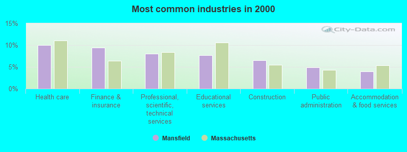
- Health care (10.0%)
- Finance & insurance (9.4%)
- Professional, scientific, technical services (8.1%)
- Educational services (7.6%)
- Construction (6.6%)
- Public administration (4.9%)
- Accommodation & food services (3.9%)
- Construction (11.3%)
- Finance & insurance (9.7%)
- Professional, scientific, technical services (8.8%)
- Public administration (5.7%)
- Computer & electronic products (5.2%)
- Health care (4.5%)
- Miscellaneous manufacturing (3.6%)
- Health care (16.4%)
- Educational services (12.4%)
- Finance & insurance (9.1%)
- Professional, scientific, technical services (7.3%)
- Accommodation & food services (5.0%)
- Social assistance (4.0%)
- Public administration (3.9%)
- Other management occupations, except farmers and farm managers (5.9%)
- Computer specialists (5.1%)
- Other sales and related occupations, including supervisors (4.0%)
- Other office and administrative support workers, including supervisors (3.7%)
- Material recording, scheduling, dispatching, and distributing workers (3.5%)
- Top executives (3.1%)
- Preschool, kindergarten, elementary, and middle school teachers (2.9%)
- Other management occupations, except farmers and farm managers (7.1%)
- Computer specialists (6.5%)
- Other sales and related occupations, including supervisors (5.3%)
- Top executives (4.7%)
- Engineers (4.5%)
- Material recording, scheduling, dispatching, and distributing workers (4.5%)
- Operations specialties managers, except financial managers (3.8%)
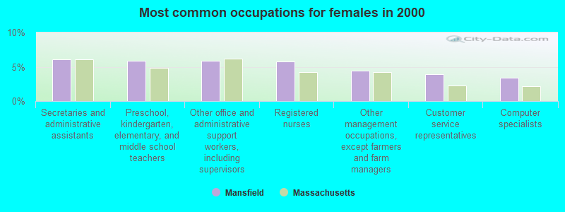
- Secretaries and administrative assistants (6.1%)
- Preschool, kindergarten, elementary, and middle school teachers (5.9%)
- Other office and administrative support workers, including supervisors (5.9%)
- Registered nurses (5.7%)
- Other management occupations, except farmers and farm managers (4.4%)
- Customer service representatives (3.9%)
- Computer specialists (3.4%)
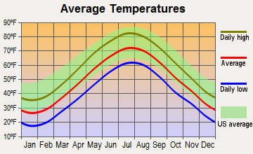
Average climate in Mansfield, Massachusetts
Based on data reported by over 4,000 weather stations
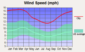
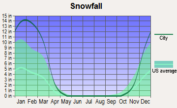
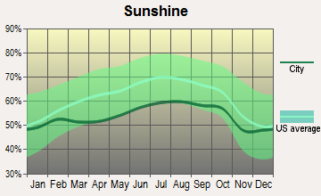
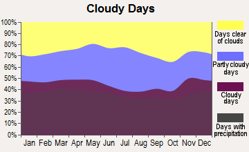
(lower is better)
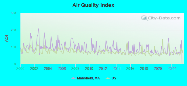
Air Quality Index (AQI) level in 2022 was 69.8. This is about average.
| City: | 69.8 |
| U.S.: | 72.6 |
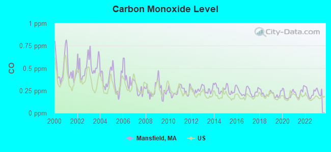
Carbon Monoxide (CO) [ppm] level in 2022 was 0.224. This is about average. Closest monitor was 13.1 miles away from the city center.
| City: | 0.224 |
| U.S.: | 0.251 |
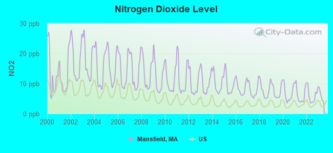
Nitrogen Dioxide (NO2) [ppb] level in 2022 was 6.15. This is worse than average. Closest monitor was 4.7 miles away from the city center.
| City: | 6.15 |
| U.S.: | 5.11 |
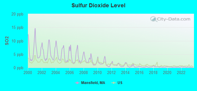
Sulfur Dioxide (SO2) [ppb] level in 2022 was 0.232. This is significantly better than average. Closest monitor was 6.6 miles away from the city center.
| City: | 0.232 |
| U.S.: | 1.515 |
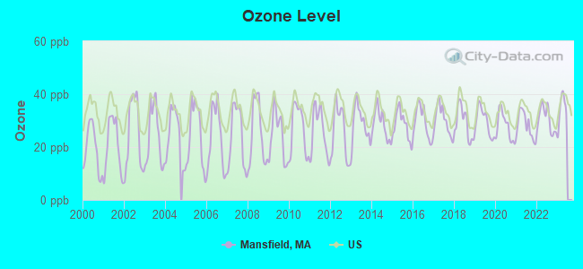
Ozone [ppb] level in 2022 was 30.4. This is about average. Closest monitor was 6.6 miles away from the city center.
| City: | 30.4 |
| U.S.: | 33.3 |
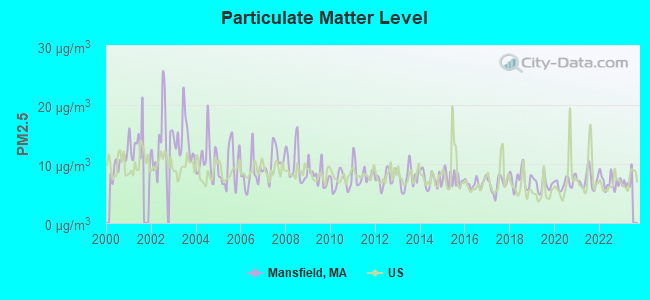
Particulate Matter (PM2.5) [µg/m3] level in 2022 was 7.02. This is about average. Closest monitor was 11.1 miles away from the city center.
| City: | 7.02 |
| U.S.: | 8.11 |
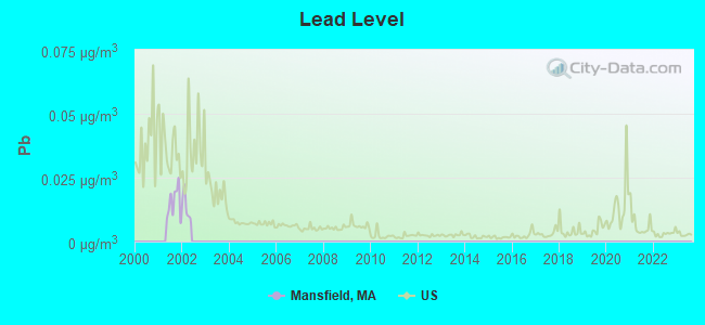
Lead (Pb) [µg/m3] level in 2001 was 0.0152. This is significantly worse than average. Closest monitor was 11.3 miles away from the city center.
| City: | 0.0152 |
| U.S.: | 0.0093 |
Tornado activity:
Mansfield-area historical tornado activity is slightly below Massachusetts state average. It is 48% smaller than the overall U.S. average.
On 6/9/1953, a category F4 (max. wind speeds 207-260 mph) tornado 24.8 miles away from the Mansfield town center killed 90 people and injured 1228 people and caused between $50,000,000 and $500,000,000 in damages.
On 6/9/1953, a category F3 (max. wind speeds 158-206 mph) tornado 2.3 miles away from the town center injured 17 people and caused between $500,000 and $5,000,000 in damages.
Earthquake activity:
Mansfield-area historical earthquake activity is significantly above Massachusetts state average. It is 74% smaller than the overall U.S. average.On 10/7/1983 at 10:18:46, a magnitude 5.3 (5.1 MB, 5.3 LG, 5.1 ML, Class: Moderate, Intensity: VI - VII) earthquake occurred 207.0 miles away from Mansfield center
On 4/20/2002 at 10:50:47, a magnitude 5.3 (5.3 ML, Depth: 3.0 mi) earthquake occurred 212.8 miles away from the city center
On 1/19/1982 at 00:14:42, a magnitude 4.7 (4.5 MB, 4.7 MD, 4.5 LG, Class: Light, Intensity: IV - V) earthquake occurred 104.2 miles away from Mansfield center
On 4/20/2002 at 10:50:47, a magnitude 5.2 (5.2 MB, 4.2 MS, 5.2 MW, 5.0 MW) earthquake occurred 212.0 miles away from Mansfield center
On 10/16/2012 at 23:12:25, a magnitude 4.7 (4.7 ML, Depth: 10.0 mi) earthquake occurred 112.8 miles away from Mansfield center
On 8/22/1992 at 12:20:32, a magnitude 4.8 (4.8 MB, 3.8 MS, 4.7 LG, Depth: 6.2 mi) earthquake occurred 207.0 miles away from the city center
Magnitude types: regional Lg-wave magnitude (LG), body-wave magnitude (MB), duration magnitude (MD), local magnitude (ML), surface-wave magnitude (MS), moment magnitude (MW)
Natural disasters:
The number of natural disasters in Bristol County (23) is greater than the US average (15).Major Disasters (Presidential) Declared: 12
Emergencies Declared: 11
Causes of natural disasters: Floods: 8, Hurricanes: 7, Storms: 5, Snows: 3, Snowstorms: 3, Winter Storms: 3, Blizzards: 2, Explosion: 1, Heavy Rain: 1, Snowfall: 1, Tropical Storm: 1, Wind: 1 (Note: some incidents may be assigned to more than one category).

Main business address for: HELIX TECHNOLOGY CORP (SPECIAL INDUSTRY MACHINERY, NEC), AXEDA SYSTEMS INC (SERVICES-PREPACKAGED SOFTWARE).
Hospitals and medical centers near Mansfield:
- COUNTRY HAVEN NURS HME INC (Nursing Home, about 3 miles away; NORTON, MA)
- EPOCH SENIOR HEALTHCARE OF NORTON (Nursing Home, about 3 miles away; NORTON, MA)
- VAN-DORA NURSING HOME (Nursing Home, about 4 miles away; FOXBORO, MA)
- GOLDEN LIVING CENTER - GARDEN PLACE (Nursing Home, about 5 miles away; ATTLEBORO, MA)
- PLEASANT MANOR NURSING HOME (Nursing Home, about 5 miles away; ATTLEBORO, MA)
- PLAINVILLE NRSG HME (Nursing Home, about 6 miles away; PLAINVILLE, MA)
- STURDY MEMORIAL HOSPITAL Acute Care Hospitals (about 7 miles away; ATTLEBORO, MA)
Airports located in Mansfield:
- Mansfield Municipal Airport (1B9) (Runways: 2, Air Taxi Ops: 1,200, Itinerant Ops: 16,000, Local Ops: 30,000, Military Ops: 750)
Amtrak stations near Mansfield:
- 14 miles: ROUTE 128 (WESTWOOD, UNIVERSITY AVE. & RTE. 128) . Services: ticket office, enclosed waiting area, public restrooms, public payphones, vending machines, paid short-term parking, taxi stand, public transit connection.
- 17 miles: PROVIDENCE (100 GASPEE ST.) . Services: ticket office, fully wheelchair accessible, enclosed waiting area, public restrooms, public payphones, snack bar, ATM, paid short-term parking, paid long-term parking, call for car rental service, taxi stand, public transit connection.
Colleges/universities with over 2000 students nearest to Mansfield:
- Stonehill College (about 8 miles; Easton, MA; Full-time enrollment: 2,563)
- Massasoit Community College (about 13 miles; Brockton, MA; FT enrollment: 5,442)
- Bridgewater State University (about 14 miles; Bridgewater, MA; FT enrollment: 9,802)
- Curry College (about 17 miles; Milton, MA; FT enrollment: 2,586)
- Brown University (about 17 miles; Providence, RI; FT enrollment: 8,458)
- Rhode Island School of Design (about 17 miles; Providence, RI; FT enrollment: 2,714)
- Providence College (about 17 miles; Providence, RI; FT enrollment: 4,312)
Public high school in Mansfield:
- MANSFIELD HIGH (Students: 1,355, Location: 250 EAST STREET, Grades: 9-12)
Private high school in Mansfield:
Public elementary/middle schools in Mansfield:
- HAROLD L QUALTERS MIDDLE (Students: 1,217, Location: 240 EAST STREET, Grades: 6-8)
- JORDAN/JACKSON ELEMENTARY (Students: 1,156, Location: 255 EAST STREET, Grades: 3-5)
- EVERETT W ROBINSON (Students: 1,062, Location: 245 EAST STREET, Grades: KG-2)
Private elementary/middle school in Mansfield:
Points of interest:
Notable locations in Mansfield: Mansfield Station (A), Comcast Center (B), Willowdale Golf Club (C), Mansfield Fire Department Station 1 Headquarters (D), Albany International Research Library (E), Mansfield Fire Department Station 2 (F), Mansfield High School Library (G), Mansfield Library (H). Display/hide their locations on the map
Main business address in Mansfield include: HELIX TECHNOLOGY CORP (A), AXEDA SYSTEMS INC (B). Display/hide their locations on the map
Church in Mansfield: Christian and Missionary Alliance Church (A). Display/hide its location on the map
Cemeteries: Saint Marys Cemetery (1), Spring Brook Cemetery (2), Quaker Cemetery (3). Display/hide their locations on the map
Lakes, reservoirs, and swamps: Whiteville Pond (A), Robinson Pond (B), Fulton Pond (C), Kingman Pond (D), Wading River Reservoir (E), Witch Pond Swamp (F), Lowlands (G). Display/hide their locations on the map
Streams, rivers, and creeks: Henkes Brook (A), Robinson Brook (B). Display/hide their locations on the map
Parks in Mansfield include: Mansfield Memorial Park (1), Ball Park (2). Display/hide their locations on the map
Tourist attraction: Mansfield Travel Inc (Tours & Charters; 191 N Main) (1). Display/hide its approximate location on the map
Hotels: Motel 6 (60 Forbes Boulevard) (1), Holiday Inn Mansfield Foxoboro (31 Hampshire Street) (2), Red Roof Inn (60 Forbes Boulevard) (3). Display/hide their approximate locations on the map
Birthplace of: Charlie Romero - Soccer player, Don Currivan - Football player, Joe Vernon - Major League Baseball pitcher.
Drinking water stations with addresses in Mansfield and their reported violations in the past:
MANSFIELD WATER DIVISION (Population served: 24,000, Purch surface water):Past health violations:
- MCL, Monthly (TCR) - In JUL-2009, Contaminant: Coliform. Follow-up actions: St AO (w/o penalty) issued (NOV-20-2009), St Compliance achieved (NOV-20-2009)
| This town: | 2.8 people |
| Massachusetts: | 2.5 people |
| This town: | 71.7% |
| Whole state: | 63.0% |
| This town: | 5.5% |
| Whole state: | 7.0% |
Likely homosexual households (counted as self-reported same-sex unmarried-partner households)
- Lesbian couples: 0.5% of all households
- Gay men: 0.3% of all households
| This town: | 4.5% |
| Whole state: | 9.3% |
| This town: | 2.5% |
| Whole state: | 4.4% |
People in group quarters in Mansfield in 2010:
- 11 people in other noninstitutional facilities
- 10 people in group homes for juveniles (non-correctional)
- 7 people in group homes intended for adults
17 people in other noninstitutional group quarters in 2000
Banks with branches in Mansfield (2011 data):
- Mansfield Co-operative Bank: Mansfield Co-Operative Bank at 80 North Main Street, branch established on 1883/01/01. Info updated 2006/11/03: Bank assets: $358.2 mil, Deposits: $303.5 mil, local headquarters, positive income, Commercial Lending Specialization, 5 total offices
- RBS Citizens, National Association: Mansfield Stop & Shop Branch at 377 Chauncy Street, branch established on 2002/04/17. Info updated 2007/09/19: Bank assets: $106,940.6 mil, Deposits: $75,690.2 mil, headquarters in Providence, RI, positive income, 1135 total offices, Holding Company: Uk Financial Investments Limited
- TD Bank, National Association: Mansfield Branch at 280 School Street Suite B100, branch established on 2007/12/19. Info updated 2010/10/04: Bank assets: $188,912.6 mil, Deposits: $153,149.8 mil, headquarters in Wilmington, DE, positive income, 1314 total offices, Holding Company: Toronto-Dominion Bank, The
- Bank of America, National Association: Mansfield Branch at 355 North Main Street, branch established on 1962/07/02. Info updated 2009/11/18: Bank assets: $1,451,969.3 mil, Deposits: $1,077,176.8 mil, headquarters in Charlotte, NC, positive income, 5782 total offices, Holding Company: Bank Of America Corporation
- North Easton Savings Bank: Mansfield Branch at 71 Copeland Drive, branch established on 1994/06/13. Info updated 2009/05/22: Bank assets: $466.2 mil, Deposits: $421.0 mil, headquarters in South Easton, MA, positive income, Mortgage Lending Specialization, 9 total offices
For population 15 years and over in Mansfield:
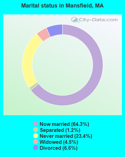
- Never married: 23.4%
- Now married: 64.3%
- Separated: 1.2%
- Widowed: 4.5%
- Divorced: 6.5%
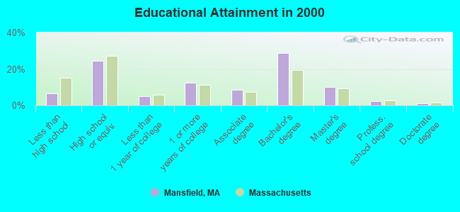
For population 25 years and over in Mansfield:
- High school or higher: 93.2%
- Bachelor's degree or higher: 42.1%
- Graduate or professional degree: 13.4%
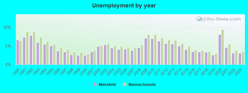
- Unemployed: 3.5%
- Mean travel time to work (commute): 33.3 minutes
| Here: | 9.9 |
| Massachusetts average: | 13.1 |
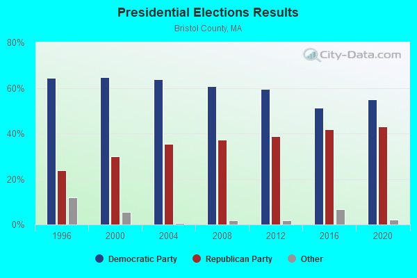
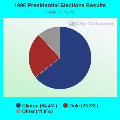
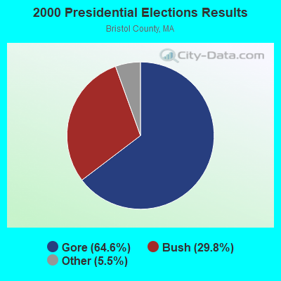
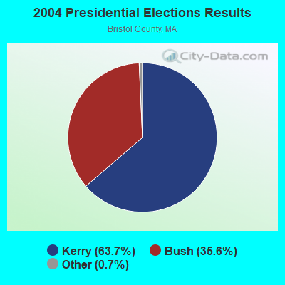
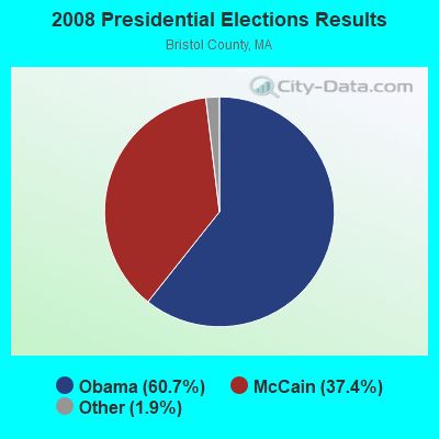
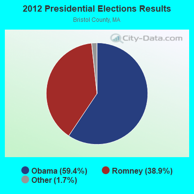
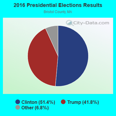
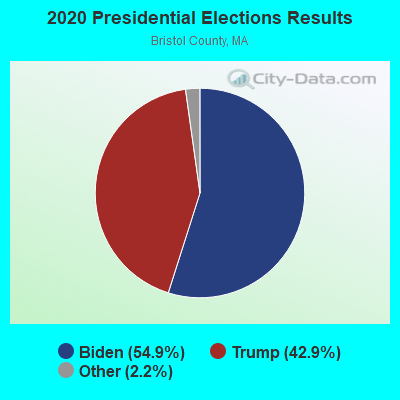
Graphs represent county-level data. Detailed 2008 Election Results
Religion statistics for Mansfield, MA (based on Bristol County data)
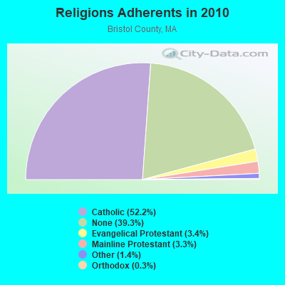
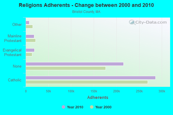
| Religion | Adherents | Congregations |
|---|---|---|
| Catholic | 286,113 | 72 |
| Evangelical Protestant | 18,765 | 128 |
| Mainline Protestant | 18,246 | 83 |
| Other | 7,807 | 33 |
| Orthodox | 1,565 | 4 |
| Black Protestant | 511 | 5 |
| None | 215,278 | - |
Food Environment Statistics:
| This county: | 2.00 / 10,000 pop. |
| State: | 1.98 / 10,000 pop. |
| Bristol County: | 0.09 / 10,000 pop. |
| State: | 0.05 / 10,000 pop. |
| Bristol County: | 1.93 / 10,000 pop. |
| Massachusetts: | 2.22 / 10,000 pop. |
| Bristol County: | 2.35 / 10,000 pop. |
| Massachusetts: | 1.77 / 10,000 pop. |
| Bristol County: | 8.20 / 10,000 pop. |
| Massachusetts: | 8.76 / 10,000 pop. |
| Here: | 9.5% |
| Massachusetts: | 8.1% |
| Bristol County: | 26.9% |
| Massachusetts: | 22.5% |
| Bristol County: | 14.4% |
| Massachusetts: | 16.5% |
4.76% of this county's 2021 resident taxpayers lived in other counties in 2020 ($70,162 average adjusted gross income)
| Here: | 4.76% |
| Massachusetts average: | 6.35% |
0.01% of residents moved from foreign countries ($64 average AGI)
Bristol County: 0.01% Massachusetts average: 0.01%
Top counties from which taxpayers relocated into this county between 2020 and 2021:
| from Plymouth County, MA | |
| from Norfolk County, MA | |
| from Providence County, RI |
4.63% of this county's 2020 resident taxpayers moved to other counties in 2021 ($72,404 average adjusted gross income)
| Here: | 4.63% |
| Massachusetts average: | 7.18% |
0.01% of residents moved to foreign countries ($83 average AGI)
Bristol County: 0.01% Massachusetts average: 0.02%
Top counties to which taxpayers relocated from this county between 2020 and 2021:
| to Plymouth County, MA | |
| to Providence County, RI | |
| to Norfolk County, MA |
| Businesses in Mansfield, MA | ||||
| Name | Count | Name | Count | |
|---|---|---|---|---|
| AT&T | 2 | Kohl's | 1 | |
| American Eagle Outfitters | 1 | MasterBrand Cabinets | 11 | |
| Ann Taylor | 1 | Nike | 2 | |
| CVS | 1 | Payless | 1 | |
| Chico's | 1 | Qdoba Mexican Grill | 1 | |
| Chipotle | 1 | RadioShack | 1 | |
| Cold Stone Creamery | 1 | Red Roof Inn | 1 | |
| Coldwater Creek | 1 | Rite Aid | 1 | |
| Curves | 1 | Shaw's | 1 | |
| Domino's Pizza | 1 | Sprint Nextel | 1 | |
| Dunkin Donuts | 4 | Staples | 1 | |
| Famous Footwear | 1 | Stop & Shop | 1 | |
| FedEx | 4 | Subway | 1 | |
| GNC | 2 | T.G.I. Driday's | 1 | |
| GameStop | 1 | True Value | 1 | |
| H&R Block | 1 | UPS | 5 | |
| Holiday Inn | 1 | Verizon Wireless | 1 | |
| Home Depot | 1 | Wendy's | 1 | |
| JoS. A. Bank | 1 | YMCA | 1 | |
| Justice | 1 | |||
Strongest AM radio stations in Mansfield:
- WEEI (850 AM; 50 kW; BOSTON, MA; Owner: ENTERCOM BOSTON LICENSE, LLC)
- WALE (990 AM; 50 kW; GREENVILLE, RI; Owner: NORTH AMERICAN BROADCASTING CO., INC.)
- WKOX (1200 AM; 50 kW; FRAMINGHAM, MA; Owner: CAPSTAR TX LIMITED PARTNERSHIP)
- WBIX (1060 AM; 40 kW; NATICK, MA; Owner: LANGER BROADCASTING CORPORATION)
- WARL (1320 AM; 5 kW; ATTLEBORO, MA; Owner: THE ADD RADIO GROUP, INC.)
- WAMG (890 AM; 25 kW; DEDHAM, MA; Owner: MEGA COMMUNICATIONS OF DEDHAM LICENSEE, LLC)
- WBZ (1030 AM; 50 kW; BOSTON, MA; Owner: INFINITY BROADCASTING OPERATIONS, INC.)
- WRKO (680 AM; 50 kW; BOSTON, MA; Owner: ENTERCOM BOSTON LICENSE, LLC)
- WWZN (1510 AM; 50 kW; BOSTON, MA; Owner: ROSE CITY RADIO CORPORATION)
- WDDZ (550 AM; 5 kW; PAWTUCKET, RI; Owner: ABC, INC.)
- WBET (1460 AM; 5 kW; BROCKTON, MA; Owner: KJI BROADCASTING, LLC)
- WCRN (830 AM; 50 kW; WORCESTER, MA; Owner: CARTER BROADCASTING CORPORATION)
- WUNR (1600 AM; 20 kW; BROOKLINE, MA; Owner: CHAMPION BROADCASTING SYSTEMS, INC.)
Strongest FM radio stations in Mansfield:
- WWBB (101.5 FM; PROVIDENCE, RI; Owner: CLEAR CHANNEL BROADCASTING LICENSES, INC.)
- WBOT (97.7 FM; BROCKTON, MA; Owner: RADIO ONE LICENSES, LLC)
- WSNE-FM (93.3 FM; TAUNTON, MA; Owner: CAPSTAR TX LIMITED PARTNERSHIP)
- WBMX (98.5 FM; BOSTON, MA; Owner: INFINITY RADIO OPERATIONS INC.)
- WBOS (92.9 FM; BROOKLINE, MA; Owner: GREATER BOSTON RADIO, INC.)
- WJMN (94.5 FM; BOSTON, MA; Owner: AMFM RADIO LICENSES, L.L.C.)
- WCRB (102.5 FM; WALTHAM, MA; Owner: CHARLES RIVER BROADCASTING WCRB LICE)
- WTKK (96.9 FM; BOSTON, MA; Owner: GREATER BOSTON RADIO, INC.)
- WROR-FM (105.7 FM; FRAMINGHAM, MA; Owner: GREATER BOSTON RADIO, INC.)
- WGBH (89.7 FM; BOSTON, MA; Owner: WGBH EDUCATIONAL FOUNDATION)
- WBUR-FM (90.9 FM; BOSTON, MA; Owner: TRUSTEES OF BOSTON UNIVERSITY)
- WXKS-FM (107.9 FM; MEDFORD, MA; Owner: AMFM RADIO LICENSES, L.L.C.)
- WMJX (106.7 FM; BOSTON, MA; Owner: GREATER BOSTON RADIO, INC.)
- WODS (103.3 FM; BOSTON, MA; Owner: INFINITY BROADCASTING OPERATIONS, INC.)
- WBRU (95.5 FM; PROVIDENCE, RI; Owner: BROWN BROADCASTING SERVICE, INC.)
- WWKX (106.3 FM; WOONSOCKET, RI; Owner: AAA ENTERTAINMENT LICENSING LLC)
- WHJY (94.1 FM; PROVIDENCE, RI; Owner: CAPSTAR TX LIMITED PARTNERSHIP)
- WBCN (104.1 FM; BOSTON, MA; Owner: HEMISPHERE BROADCASTING CORPORATION)
- WZLX (100.7 FM; BOSTON, MA; Owner: INFINITY BROADCASTING CORPORATION OF BOSTON)
- W267AI (101.3 FM; BOSTON, MA; Owner: MCC BROADCASTING COMPANY, INC.)
TV broadcast stations around Mansfield:
- WWDP (Channel 46; NORWELL, MA; Owner: NORWELL TELEVISION, LLC)
- WPRI-TV (Channel 12; PROVIDENCE, RI; Owner: TVL BROADCASTING OF RHODE ISLAND, LLC)
- WLNE-TV (Channel 6; NEW BEDFORD, MA; Owner: FREEDOM BROADCASTING OF SOUTHERN NEW ENGLAND, INC.)
- WNAC-TV (Channel 64; PROVIDENCE, RI; Owner: WNAC, LLC)
- WJAR (Channel 10; PROVIDENCE, RI; Owner: OUTLET BROADCASTING, INC.)
- WCVB-TV (Channel 5; BOSTON, MA; Owner: WCVB HEARST-ARGYLE TV, INC.)
- WSBE-TV (Channel 36; PROVIDENCE, RI; Owner: RHODE ISLAND PUBLIC TELECOM. AUTHORITY)
- WGBH-TV (Channel 2; BOSTON, MA; Owner: WGBH EDUCATIONAL FOUNDATION)
- WHDH-TV (Channel 7; BOSTON, MA; Owner: WHDH-TV)
- WMFP (Channel 62; LAWRENCE, MA; Owner: WSAH LICENSE, INC.)
- WSBK-TV (Channel 38; BOSTON, MA; Owner: VIACOM INC.)
- WLVI-TV (Channel 56; CAMBRIDGE, MA; Owner: WLVI, INC.)
- WBZ-TV (Channel 4; BOSTON, MA; Owner: VIACOM INC.)
- WGBX-TV (Channel 44; BOSTON, MA; Owner: WGBH EDUCATIONAL FOUNDATION)
- WFXT (Channel 25; BOSTON, MA; Owner: FOX TELEVISION STATIONS INC.)
- W40BO (Channel 40; BOSTON, MA; Owner: PAXSON COMMUNICATIONS LPTV, INC.)
- WBPX (Channel 68; BOSTON, MA; Owner: PAXSON BOSTON-68 LICENSE, INC.)
- WUTF (Channel 66; MARLBOROUGH, MA; Owner: TELEFUTURA BOSTON LLC)
- WUNI (Channel 27; WORCESTER, MA; Owner: ENTRAVISION HOLDINGS, LLC)
- WTMU-LP (Channel 32; BOSTON, MA; Owner: ZGS BOSTON, INC.)
- WCEA-LP (Channel 58; BOSTON, MA; Owner: CHANNEL 19 TV CORPORATION)
- WLWC (Channel 28; NEW BEDFORD, MA; Owner: C-28 FCC LICENSEE SUBSIDIARY, LLC)
- WPXQ (Channel 69; BLOCK ISLAND, RI; Owner: OCEAN STATE TELEVISION, L.L.C.)
- WRIW-LP (Channel 50; PROVIDENCE, RI; Owner: ZGS PROVIDENCE, INC.)
- National Bridge Inventory (NBI) Statistics
- 33Number of bridges
- 344ft / 105mTotal length
- $78,635,000Total costs
- 718,487Total average daily traffic
- 36,021Total average daily truck traffic
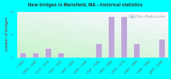
- New bridges - historical statistics
- 1Before 1900
- 11900-1909
- 21910-1919
- 11920-1929
- 31950-1959
- 91960-1969
- 91970-1979
- 31980-1989
- 42000-2009
FCC Registered Cell Phone Towers:
1 (See the full list of FCC Registered Cell Phone Towers in Mansfield)FCC Registered Antenna Towers:
61 (See the full list of FCC Registered Antenna Towers)FCC Registered Private Land Mobile Towers:
1 (See the full list of FCC Registered Private Land Mobile Towers in Mansfield, MA)FCC Registered Broadcast Land Mobile Towers:
20 (See the full list of FCC Registered Broadcast Land Mobile Towers)FCC Registered Microwave Towers:
2- BOS1802, 33 Suffolk Rd (Lat: 42.024611 Lon: -71.239667), Type: Tower, Structure height: 54.8 m, Call Sign: WQHM672, Licensee ID: L01728370,
Assigned Frequencies: 19460.0 MHz, Grant Date: 09/11/2007, Expiration Date: 09/11/2017, Cancellation Date: 09/09/2013, Certifier: Joseph M Sandri Jr., Registrant: Fibertower Network Services, Corp., Debtor-In-Possession, 1875 Eye Street, Nw, 5th Floor, Room 505, Washington, DC 20006, Phone: (202) 223-1028, Email:
- Mansfield MA 2, 33 Suffolk Rd (Lat: 42.024611 Lon: -71.239667), Type: Tower, Structure height: 54.8 m, Call Sign: WQIL275,
Assigned Frequencies: 11115.0 MHz, Grant Date: 03/07/2008, Expiration Date: 03/07/2018, Cancellation Date: 09/07/2009, Certifier: William Chastain, Registrant: Radio Dynamics Corporation, Silver Spring, MD 20914, Phone: (301) 493-5171, Fax: (301) 576-4553, Email:
FCC Registered Maritime Coast & Aviation Ground Towers:
3- Mansfield Municipal Airport (Lat: 42.000389 Lon: -71.208111), Type: Building, Overall height: 11 m, Call Sign: KNL5,
Assigned Frequencies: 123.000 MHz, Grant Date: 02/13/1997, Expiration Date: 02/13/2002, Cancellation Date: 05/19/2002, Registrant: King Aviation Mansfield Inc, 265 Fruit St, Mansfield, MA 02048
- Mansfield Municipal Airport (Lat: 42.002778 Lon: -71.197222), Type: Tower, Call Sign: WRLB2952,
Assigned Frequencies: 0.22051 MHz, Grant Date: 06/26/2008, Expiration Date: 05/20/2018, Cancellation Date: 07/21/2018, Registrant: Massachusetts Department Of Transportation - Aeronautics Division, 1 Harborside Drive, Suite 205n, Boston, MA 02128, Phone: (617) 412-3678, Fax: (617) 412-3679, Email:
- Mansfield Airport - Nexair Avionics Llc 265 Fruit Street (Lat: 42.000111 Lon: -71.196750), Type: Bant, Structure height: 8 m, Overall height: 11 m, Call Sign: WQIU477,
Assigned Frequencies: 122.775 MHz, Grant Date: 05/15/2008, Expiration Date: 05/15/2018, Cancellation Date: 07/21/2018, Certifier: David L Fetherston, Registrant: Nexair Avionics LLC, 265 Fruit Street, Mansfield, MA 02048, Phone: (508) 339-7077, Fax: (508) 339-7088, Email:
FCC Registered Amateur Radio Licenses:
115 (See the full list of FCC Registered Amateur Radio Licenses in Mansfield)FAA Registered Aircraft Manufacturers and Dealers:
1 (See the full list of FAA Registered Manufacturers and Dealers in Mansfield)FAA Registered Aircraft:
14 (See the full list of FAA Registered Aircraft)2002 - 2018 National Fire Incident Reporting System (NFIRS) incidents
- Fire incident types reported to NFIRS in Mansfield, MA
- 43836.9%Outside Fires
- 39633.4%Structure Fires
- 24120.3%Mobile Property/Vehicle Fires
- 1129.4%Other
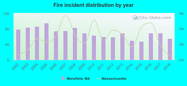 Based on the data from the years 2002 - 2018 the average number of fire incidents per year is 70. The highest number of fire incidents - 95 took place in 2005, and the least - 48 in 2015. The data has a decreasing trend.
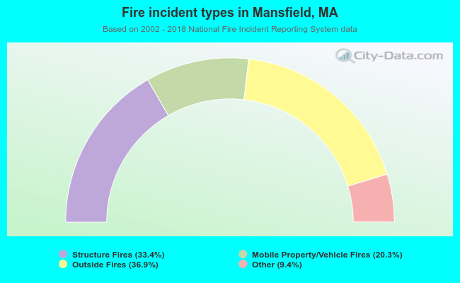 When looking into fire subcategories, the most reports belonged to: Outside Fires (36.9%), and Structure Fires (33.4%).
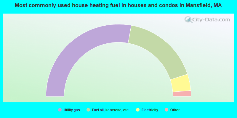
- 55.6%Utility gas
- 34.3%Fuel oil, kerosene, etc.
- 7.4%Electricity
- 1.7%Bottled, tank, or LP gas
- 0.9%Wood
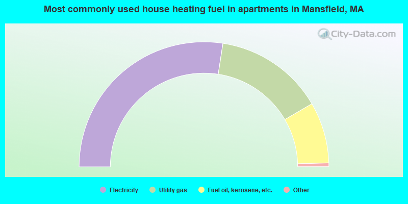
- 54.8%Electricity
- 28.3%Utility gas
- 15.8%Fuel oil, kerosene, etc.
- 0.6%Bottled, tank, or LP gas
- 0.4%Other fuel
Mansfield compared to Massachusetts state average:
- Unemployed percentage significantly below state average.
- Black race population percentage below state average.
- Hispanic race population percentage significantly below state average.
- Foreign-born population percentage significantly below state average.
- Length of stay since moving in significantly above state average.
- Number of rooms per house significantly below state average.
- House age significantly below state average.
Mansfield on our top lists:
- #24 on the list of "Top 101 cities with largest percentage of males in occupations: operations specialties managers except financial managers (population 5,000+)"
- #50 on the list of "Top 101 cities with largest percentage of males in industries: data processing, libraries, and other information services (population 5,000+)"
- #52 on the list of "Top 101 cities with the most people taking railroad to work (population 5,000+)"
- #58 on the list of "Top 101 cities with largest percentage of males in occupations: financial managers (population 5,000+)"
- #62 on the list of "Top 101 cities with largest percentage of males in industries: broadcasting and telecommunications (population 5,000+)"
- #63 on the list of "Top 101 cities with largest percentage of females in occupations: accountants and auditors (population 5,000+)"
- #63 on the list of "Top 101 cities with largest percentage of females in industries: paper and paper products merchant wholesalers (population 5,000+)"
- #64 on the list of "Top 101 cities with largest percentage of males in industries: miscellaneous manufacturing (population 5,000+)"
- #68 on the list of "Top 101 cities with largest percentage of females in occupations: mathematical science occupations (population 5,000+)"
- #80 on the list of "Top 101 cities with largest percentage of females in industries: electronic shopping and mail-order houses (population 5,000+)"
- #81 on the list of "Top 101 cities with largest percentage of females in industries: rail transportation (population 5,000+)"
- #85 on the list of "Top 101 cities with largest percentage of males in industries: electrical and electronic goods merchant wholesalers (population 5,000+)"
- #86 on the list of "Top 101 cities with largest percentage of females in industries: miscellaneous manufacturing (population 5,000+)"
- #90 on the list of "Top 101 cities with largest percentage of females in occupations: computer specialists (population 5,000+)"
- #92 on the list of "Top 101 cities with largest percentage of males in industries: furniture and home furnishing merchant wholesalers (population 5,000+)"
- #93 on the list of "Top 101 cities with largest percentage of females in industries: data processing, libraries, and other information services (population 5,000+)"
- #93 on the list of "Top 101 cities with largest percentage of males in industries: pharmacies and drug stores (population 5,000+)"
- #94 on the list of "Top 101 cities with largest percentage of males in occupations: computer specialists (population 5,000+)"
- #96 on the list of "Top 101 cities with largest percentage of males in industries: leather and allied products (population 5,000+)"
- #100 on the list of "Top 101 cities with largest percentage of females in industries: professional and commercial equipment and supplies merchant wholesalers (population 5,000+)"
- #14 on the list of "Top 101 counties with the lowest percentage of residents that keep firearms around their homes"
- #29 on the list of "Top 101 counties with the lowest percentage of residents relocating to foreign countries in 2011 (pop. 50,000+)"
- #32 on the list of "Top 101 counties with the most Catholic congregations"
- #34 on the list of "Top 101 counties with the highest percentage of residents that smoked 100+ cigarettes in their lives"
- #41 on the list of "Top 101 counties with the most Catholic adherents"

|
|
Total of 765 patent applications in 2008-2024.