St Johns, Ohio
Submit your own pictures of this place and show them to the world
- OSM Map
- Google Map
- MSN Map
| Males: 80 | |
| Females: 105 |
| Median resident age: | 35.1 years |
| Ohio median age: | 39.9 years |
Zip code: 45884
| St Johns: | $73,805 |
| OH: | $65,720 |
Estimated per capita income in 2022: $37,047
Estimated median house or condo value in 2022: $187,287
| St Johns: | $187,287 |
| OH: | $204,100 |
Mean prices in 2022: all housing units: $167,219; detached houses: $167,697
Median gross rent in 2022: $1,035.
Detailed information about poverty and poor residents in St Johns, OH
Compare current foreclosures near your location:
| Photo | Address | Area | Beds / Baths | Price | Details |
|---|---|---|---|---|---|

|
#1
N Rhodes St
Pretty Prairie, KS 67570
|
1,725 sq. feet
|
2 baths 4 beds |
show details | |

|
#2
S Goddard Rd
Goddard, KS 67052
|
1,054 sq. feet
|
2 baths 2 beds |
show details | |

|
#3
W 21st St N
Cheney, KS 67025
|
3,190 sq. feet
|
3 baths 5 beds |
show details | |

|
#4
E Winterset St
Goddard, KS 67052
|
816 sq. feet
|
1 baths 2 beds |
show details | |

|
#5
NE Waterloo Ave
Murdock, KS 67111
|
1,220 sq. feet
|
1 baths 3 beds |
show details | |

|
#6
W 39th St S
Goddard, KS 67052
|
4,221 sq. feet
|
3 baths 3 beds |
show details | |

|
#7
E Arlington Rd
Haven, KS 67543
|
960 sq. feet
|
1 baths 2 beds |
show details | |

|
#8
S 391st St W
Cheney, KS 67025
|
2,558 sq. feet
|
3 baths 3 beds |
show details | |

|
#9
SE Viney Ave
Murdock, KS 67111
|
- sq. feet
|
- baths - beds |
show details | |

|
#10
W Main St
Mount Hope, KS 67108
|
- sq. feet
|
- baths - beds |
show details |
| Photo | Address | Area | Beds / Baths | Price | Details |
|---|---|---|---|---|---|

|
#11
N 189th Cir W
Colwich, KS 67030
|
- sq. feet
|
- baths - beds |
show details | |

|
#12
N Main St
Goddard, KS 67052
|
- sq. feet
|
- baths - beds |
show details | |

|
#13
Martens Ct
Goddard, KS 67052
|
- sq. feet
|
- baths - beds |
show details | |

|
#14
E 4th Ave Apt 1
Cheney, KS 67025
|
- sq. feet
|
- baths - beds |
show details | |

|
#15
W Maple St Lot D
Goddard, KS 67052
|
- sq. feet
|
- baths - beds |
show details | |

|
#16
W 47th St S
Garden Plain, KS 67050
|
- sq. feet
|
- baths - beds |
show details | |

|
#17
S 339th St W
Cheney, KS 67025
|
- sq. feet
|
- baths - beds |
show details | |

|
#18
E Casey Dr
Goddard, KS 67052
|
- sq. feet
|
- baths - beds |
show details | |

|
Check over 1 million property listings on Foreclosure.com!
|
browse all offers | |||

- 26191.9%White alone
- 134.6%Black alone
- 62.1%Other race alone

 Recent articles from our blog. Our writers, many of them Ph.D. graduates or candidates, create easy-to-read articles on a wide variety of topics.

Ancestries: Scottish (29.6%), German (23.5%), Norwegian (9.2%), English (8.2%), Irish (6.1%).
Current Local Time: EST time zone
Nearest city with pop. 50,000+: Springfield, OH  (45.8 miles , pop. 65,358).
Nearest city with pop. 200,000+: Fort Wayne, IN (65.6 miles , pop. 205,727).
Nearest city with pop. 1,000,000+: Chicago, IL (207.3 miles , pop. 2,896,016).
Nearest cities:
), ), ), ), ), )Latitude: 40.56 N, Longitude: 84.08 W
Area code commonly used in this area: 419


| Here: | 2.3% |
| Ohio: | 3.1% |
(lower is better)

Air Quality Index (AQI) level in 2023 was 89.1. This is worse than average.
| City: | 89.1 |
| U.S.: | 72.6 |

Sulfur Dioxide (SO2) [ppb] level in 2023 was 0.248. This is significantly better than average. Closest monitor was 11.4 miles away from the city center.
| City: | 0.248 |
| U.S.: | 1.515 |

Ozone [ppb] level in 2022 was 34.1. This is about average. Closest monitor was 14.0 miles away from the city center.
| City: | 34.1 |
| U.S.: | 33.3 |

Particulate Matter (PM2.5) [µg/m3] level in 2023 was 9.24. This is about average. Closest monitor was 15.0 miles away from the city center.
| City: | 9.24 |
| U.S.: | 8.11 |
Tornado activity:
St Johns-area historical tornado activity is slightly above Ohio state average. It is 50% greater than the overall U.S. average.
On 4/11/1965, a category F4 (max. wind speeds 207-260 mph) tornado 12.4 miles away from the St Johns place center killed 3 people and injured 50 people and caused between $500,000 and $5,000,000 in damages.
On 4/11/1965, a category F4 tornado 18.0 miles away from the place center killed 13 people and injured 104 people and caused between $500,000 and $5,000,000 in damages.
Earthquake activity:
St Johns-area historical earthquake activity is significantly above Ohio state average. It is 8% smaller than the overall U.S. average.On 7/27/1980 at 18:52:21, a magnitude 5.2 (5.1 MB, 4.7 MS, 5.0 UK, 5.2 UK, Class: Moderate, Intensity: VI - VII) earthquake occurred 162.7 miles away from St Johns center
On 7/12/1986 at 08:19:37, a magnitude 4.5 (4.5 MB, Class: Light, Intensity: IV - V) earthquake occurred 15.3 miles away from St Johns center
On 9/25/1998 at 19:52:52, a magnitude 5.2 (4.8 MB, 4.3 MS, 5.2 LG, 4.5 MW, Depth: 3.1 mi) earthquake occurred 202.8 miles away from the city center
On 1/31/1986 at 16:46:43, a magnitude 5.0 (5.0 MB) earthquake occurred 168.6 miles away from St Johns center
On 4/18/2008 at 09:36:59, a magnitude 5.4 (5.1 MB, 4.8 MS, 5.4 MW, 5.2 MW) earthquake occurred 249.8 miles away from St Johns center
On 4/18/2008 at 09:36:59, a magnitude 5.2 (5.2 MW, Depth: 8.9 mi) earthquake occurred 249.8 miles away from the city center
Magnitude types: regional Lg-wave magnitude (LG), body-wave magnitude (MB), surface-wave magnitude (MS), moment magnitude (MW)
Natural disasters:
The number of natural disasters in Auglaize County (9) is smaller than the US average (15).Major Disasters (Presidential) Declared: 5
Emergencies Declared: 2
Causes of natural disasters: Storms: 5, Floods: 4, Tornadoes: 3, Mudslides: 2, Winds: 2, Blizzard: 1, Hurricane: 1, Landslide: 1, Snowstorm: 1, Winter Storm: 1, Other: 1 (Note: some incidents may be assigned to more than one category).
Hospitals and medical centers near St Johns:
- NEW VISION NURSING AND HOME CARE, LLC (Home Health Center, about 7 miles away; WAPAKONETA, OH)
- WAPAKONETA MANOR (Nursing Home, about 7 miles away; WAPAKONETA, OH)
- AUGLAIZE ACRES (Nursing Home, about 7 miles away; WAPAKONETA, OH)
- CRIDERSVILLE HEALTHCARE CENTER (Nursing Home, about 8 miles away; CRIDERSVILLE, OH)
- INTERIM HEALTHCARE OF LIMA (Home Health Center, about 8 miles away; LIMA, OH)
- INSTITUTE FOR ORTHOPAEDIC SURGERY Acute Care Hospitals (about 11 miles away; LIMA, OH)
- LOST CREEK CARE CENTER (Nursing Home, about 13 miles away; LIMA, OH)
Colleges/universities with over 2000 students nearest to St Johns:
- James A Rhodes State College (about 13 miles; Lima, OH; Full-time enrollment: 2,689)
- University of Northwestern Ohio (about 15 miles; Lima, OH; FT enrollment: 4,231)
- Ohio Northern University (about 20 miles; Ada, OH; FT enrollment: 2,474)
- Edison State Community College (about 29 miles; Piqua, OH; FT enrollment: 2,049)
- The University of Findlay (about 42 miles; Findlay, OH; FT enrollment: 3,649)
- Clark State Community College (about 48 miles; Springfield, OH; FT enrollment: 3,689)
- Wright State University-Main Campus (about 54 miles; Dayton, OH; FT enrollment: 14,482)
Points of interest:
Notable location: Saint Johns Volunteer Fire and Rescue Department (A). Display/hide its location on the map
Church in St Johns: Saint Johns United Methodist Church (A). Display/hide its location on the map
Cemetery: Saint Johns Cemetery (1). Display/hide its location on the map
| This place: | 2.6 people |
| Ohio: | 2.4 people |
| This place: | 67.6% |
| Whole state: | 65.0% |
| This place: | 7.0% |
| Whole state: | 6.8% |
No gay or lesbian households reported
For population 15 years and over in St Johns:

- Never married: 11.1%
- Now married: 86.0%
- Separated: 0.0%
- Widowed: 2.9%
- Divorced: 0.0%
For population 25 years and over in St Johns:
- High school or higher: 83.2%
- Bachelor's degree or higher: 3.4%
- Graduate or professional degree: 0.0%


| Here: | 6.2 |
| Ohio average: | 11.0 |
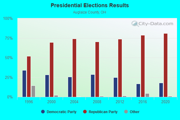
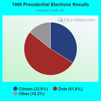


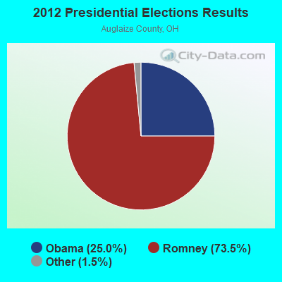


Graphs represent county-level data. Detailed 2008 Election Results
Religion statistics for St Johns, OH (based on Auglaize County data)
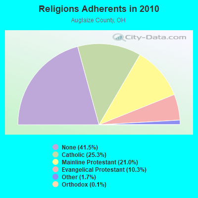
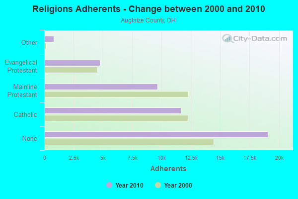
| Religion | Adherents | Congregations |
|---|---|---|
| Catholic | 11,646 | 7 |
| Mainline Protestant | 9,656 | 26 |
| Evangelical Protestant | 4,720 | 32 |
| Other | 802 | 4 |
| Orthodox | 60 | 1 |
| None | 19,065 | - |
Food Environment Statistics:
| This county: | 3.02 / 10,000 pop. |
| Ohio: | 1.89 / 10,000 pop. |
| Auglaize County: | 0.22 / 10,000 pop. |
| Ohio: | 0.13 / 10,000 pop. |
| Auglaize County: | 3.23 / 10,000 pop. |
| Ohio: | 2.93 / 10,000 pop. |
| Here: | 6.04 / 10,000 pop. |
| Ohio: | 6.25 / 10,000 pop. |
| This county: | 10.0% |
| State: | 10.3% |
| Auglaize County: | 29.9% |
| State: | 29.1% |
| Auglaize County: | 12.0% |
| Ohio: | 11.9% |
Strongest AM radio stations in St Johns:
- WIMA (1150 AM; 1 kW; LIMA, OH; Owner: JACOR BROADCASTING CORPORATION)
- WLW (700 AM; 50 kW; CINCINNATI, OH; Owner: JACOR BROADCASTING CORPORATION)
- WTVN (610 AM; 50 kW; COLUMBUS, OH; Owner: CITICASTERS LICENSES, L.P.)
- WOWO (1190 AM; 50 kW; FORT WAYNE, IN; Owner: PATHFINDER COMMUNICATIONS CORPORATION)
- WRFD (880 AM; daytime; 23 kW; COLUMBUS-WORTHINGTON, OH; Owner: SALEM MEDIA OF OHIO, INC.)
- WFDF (910 AM; 50 kW; FLINT, MI; Owner: ABC, INC.)
- WJR (760 AM; 50 kW; DETROIT, MI; Owner: ABC, INC.)
- WDFN (1130 AM; 50 kW; DETROIT, MI; Owner: AMFM RADIO LICENSES, L.L.C.)
- WKNR (850 AM; 50 kW; CLEVELAND, OH; Owner: CARON BROADCASTING, INC.)
- WCHB (1200 AM; 50 kW; TAYLOR, MI; Owner: RADIO ONE OF DETROIT, LLC)
- WSAI (1530 AM; 50 kW; CINCINNATI, OH; Owner: JACOR BROADCASTING CORPORATION)
- WIBC (1070 AM; 50 kW; INDIANAPOLIS, IN; Owner: EMMIS RADIO LICENSE CORPORATION)
- WWJ (950 AM; 50 kW; DETROIT, MI; Owner: INFINITY BROADCASTING OPERATIONS, INC.)
Strongest FM radio stations in St Johns:
- WIMT (102.1 FM; LIMA, OH; Owner: JACOR BROADCASTING CORPORATION)
- WZRX-FM (107.5 FM; FORT SHAWNEE, OH; Owner: JACOR BROADCASTING CORPORATION)
- WMLX (103.3 FM; ST. MARYS, OH; Owner: JACOR BROADCASTING CORPORATION)
- WGLE (90.7 FM; LIMA, OH; Owner: PUBLIC B/C FOUNDATION OF NW OHIO)
- WZOQ (92.1 FM; WAPAKONETA, OH; Owner: FOREVER OF OHIO, LLC)
- WYSM (89.3 FM; LIMA, OH; Owner: SIDE BY SIDE, INC.)
- WUZZ-FM (104.9 FM; LIMA, OH; Owner: FOREVER BROADCASTING, LLC)
- WBCJ (88.1 FM; SPENCERVILLE, OH; Owner: TAYLOR UNIVERSITY BROADCASTING, INC)
- WTGN (97.7 FM; LIMA, OH; Owner: ASSOCIATED CHRISTIAN BROADCASTERS)
- WFGF (93.1 FM; LIMA, OH; Owner: FOREVER OF OHIO, LLC)
- WPKO-FM (98.3 FM; BELLEFONTAINE, OH; Owner: V-TECK COMMUNICATIONS, INC.)
- WKKI (94.3 FM; CELINA, OH; Owner: SONSHINE CORP.)
- WONB (94.9 FM; ADA, OH; Owner: OHIO NORTHERN UNIVERSITY)
- WDPT (95.7 FM; PIQUA, OH; Owner: CXR HOLDINGS, INC.)
- WLWD (93.9 FM; COLUMBUS GROVE, OH; Owner: CLEAR CHANNEL BROADCASTING LICENSES, INC.)
- WBUK (106.3 FM; OTTAWA, OH; Owner: CITICASTERS LICENSES, L.P.)
- WCSM-FM (96.7 FM; CELINA, OH; Owner: HAYCO BROADCASTING, INC.)
- WDOH (107.1 FM; DELPHOS, OH; Owner: VOGEL ROACH CORPORATION)
TV broadcast stations around St Johns:
- WLMO-LP (Channel 65; LIMA, OH; Owner: METRO VIDEO PRODUCTIONS, INC.)
- W61CZ (Channel 61; LIMA, OH; Owner: YONEIDE S. DINZEY)
- W55CH (Channel 55; HOUGHTON LAKE, MI; Owner: MS COMMUNICATIONS, LLC)
- WTLW (Channel 44; LIMA, OH; Owner: AMERICAN CHRISTIAN TELEVISION SERVICES, INC.)
- WOHL-CA (Channel 25; LIMA, OH; Owner: TV-67, INC.)
- WLIO (Channel 35; LIMA, OH; Owner: LIMA COMMUNICATIONS CORPORATION)
- WBGU-TV (Channel 27; BOWLING GREEN, OH; Owner: BOWLING GREEN STATE UNIVERSITY)
- WBDT (Channel 26; SPRINGFIELD, OH; Owner: ACME TV LICENSES OF OHIO, LLC)
St Johns fatal accident list:
Feb 27, 2006 10:49 AM, Us-33, Sr-65, Lat: 40.556470, Lon: -84.084290, Vehicles: 2, Persons: 2, Fatalities: 1, Drunk persons involved: 1
- National Bridge Inventory (NBI) Statistics
- 13Number of bridges
- 59ft / 18.0mTotal length
- 19,292Total average daily traffic
- 4,630Total average daily truck traffic
- 26,265Total future (year 2035) average daily traffic

- New bridges - historical statistics
- 21960-1969
- 21970-1979
- 21980-1989
- 51990-1999
- 12000-2009
- 12010-2019
FCC Registered Amateur Radio Licenses:
1- Call Sign: KD8TQD, Licensee ID: L01750418, Grant Date: 12/03/2012, Expiration Date: 12/03/2022, Certifier: Nick M Herzog, Registrant: P.R.C., St Johns, OH 45884

- 72.5%Bottled, tank, or LP gas
- 27.5%Electricity

- 71.4%Electricity
- 28.6%Wood
St Johns compared to Ohio state average:
- Median house value below state average.
- Unemployed percentage significantly below state average.
- Hispanic race population percentage significantly below state average.
- Foreign-born population percentage significantly below state average.
- Renting percentage below state average.
- Length of stay since moving in significantly above state average.
- Number of college students significantly below state average.
- Percentage of population with a bachelor's degree or higher significantly below state average.
State forum archive:
- Ohio Pages: 2 3 4 5 6 7 8 9 10 11 12 13 14 15 16 17
- Akron - Canton Pages: 2 3 4 5
- Cincinnati Pages: 2 3 4 5 6 7 8 9 10 11 12 13 14 15 16 17 18 19 20 21 22 23 24 25
- Cleveland Pages: 2 3 4 5 6 7 8 9 10 11 12 13 14 15 16 17 18 19 20 21 22 23 24 25 26
- Columbus Pages: 2 3 4 5 6 7 8 9 10 11 12 13 14 15 16 17 18 19
- Dayton Pages: 2 3 4 5 6 7 8
- Toledo Pages: 2 3 4