Please register to participate in our discussions with 2 million other members - it's free and quick! Some forums can only be seen by registered members. After you create your account, you'll be able to customize options and access all our 15,000 new posts/day with fewer ads.
Oh, I see. I think that 600k figure might have been an underestimation for that particular chunk of land. At 140 sq miles, including the entirety of the inner-loop, it's more likely going to be closer to 800k.
Most of the near-Westside neighborhoods of the inner loop average around 9,000 per sq. mile. West University, which is downright suburban compared to other inner-loop neighborhoods, by itself is 7,500 per sq. mile. The East end neighborhoods aren't as dense, and are broken up by industrial zones.
So if you're correct on the numbers you're saying that area would be approximately 5,800 ppsm, putting it in the same league as Denver density.
So if you're correct on the numbers you're saying that area would be approximately 5,800 ppsm, putting it in the same league as Denver density.
No. As I illustrated earlier, the inner-loop by itself, currently is 6,100, and with the inclusion of Gulfton and Uptown, it would be even higher than that. If I were to guess, probably more like 8,000. I would need to know exactly where those lines would be drawn to be precise.
Also, the Westside inner-loop neighborhoods and Uptown are bulking up at a rapid pace, so in the not-so-distant future, probably even higher than that.
Any way you can highlight the area you're talking about on a map?
Any way you can highlight the area you're talking about on a map?
I could give you MY idea, but since Spade was the one who came up with the 140 figure originally, you might want to ask him. Besides, that would take some time for me to do on my aging PC. I'd have to get back to you much later on that.
Oh, I see. I think that 600k figure might have been an underestimation for that particular chunk of land. At 140 sq miles, including the entirety of the inner-loop, it's more likely going to be closer to 800k.
Most of the near-Westside neighborhoods of the inner loop average around 9,000 per sq. mile. West University, which is downright suburban compared to other inner-loop neighborhoods, by itself is 7,500 per sq. mile. The East end neighborhoods aren't as dense, and are broken up by industrial zones.
Any way you can highlight the area you're talking about on a map?
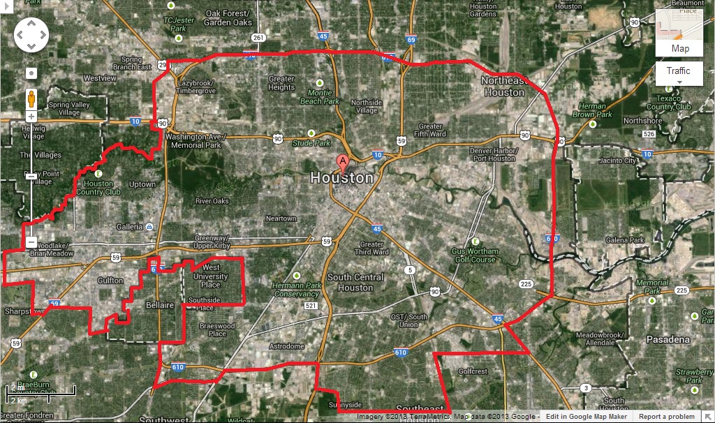
OK, here's a quick rough-n-tumble outline I did on my PC for where I would probably scale back the city limits if it were up to me. My screen-save didn't capture Hobby Airport, but I would include it as part of the city-proper, connecting it to the larger body with a tendril along Broadway.
The areas inside the loop not included here, are the incorporated cities of Bellaire, West U, and Southside Place.
Keep in mind I'm no urban planning expert, so there are probably factors I didn't take into account here.
Also, I have no way of knowing exactly how many square miles this is, but my guess would be somewhere in the 120 to 150 range. Hopefully this gives you an idea of what I've been talking about.
Who is trying to get around anythig I am just updating out of date info, Houston has not annex since kingwoods in the 90,s and sold off some land to other areas , that wanted to but it for future growth
But the point is that Houston is so big because of annexation. That's why city limits population comparisons are silly.
Going by metro makes so much more sense, because these are apples-to-apples Census-derived standards applying equally to all.
But the point is that Houston is so big because of annexation. That's why city limits population comparisons are silly.
Going by metro makes so much more sense, because these are apples-to-apples Census-derived standards applying equally to all.
Gotta say, I agree with this 100%. If the city limits were scaled back the way I proposed, Houston would probably drop from #4 to #11 or maybe even #12, but it would still be considered a big city, with equal importance in the grand scheme of things. Not to mention it would be much more manageable and have a much more solid indentity. Then San Antonio could toot it's horn as "biggest city in Texas", and Dallas could move back up to #2.
The MSA would remain just that - the MSA. Still sitting pretty at #5 with a population of 6.2 million and growing. And if all those unincorporated suburbs were to either incorporate independently or become annexed by nearby incorporated suburbs like Katy-proper, Bellaire, Sugarland, Pearland, etc., they would only stand to gain infrastructure and better services.
Please register to post and access all features of our very popular forum. It is free and quick. Over $68,000 in prizes has already been given out to active posters on our forum. Additional giveaways are planned.
Detailed information about all U.S. cities, counties, and zip codes on our site: City-data.com.

 Please register to participate in our discussions with 2 million other members - it's free and quick! Some forums can only be seen by registered members. After you create your account, you'll be able to customize options and access all our 15,000 new posts/day with fewer ads.