Please register to participate in our discussions with 2 million other members - it's free and quick! Some forums can only be seen by registered members. After you create your account, you'll be able to customize options and access all our 15,000 new posts/day with fewer ads.
I can live with either. The Bay Area is not like the others in that the largest city is located in an MSA that has less than half the population and jobs of it's neighboring MSA whose largest city is one of the most famous American cities in the world.
LOL.
Do you see a day where San Jose becomes more famous than San Francisco? It seems unlikely though San Jose is larger in population, has more room to grow due to larger land area, has been adding more people than San Francisco in recent years, and has been more inclined towards annexation of its neighbors.
Is Florida really that cheap to live in compared to Denver? I'd figure most of the northern portion of the state would be (and maybe Orlando), but what about the coastal areas? Some pretty expensive pieces of property there...
Much of Florida is poor and Denver is loaded with Hipster babies living off their parent's dime.
Critical error though--it should be San Jose not San Francisco as the largest city. Critical!
Thank you!
I noted in the bottom that my naming scheme was slightly different: "I named the PCSAs after the largest city in their largest constituent metro, for brevity"
These are the constituent metros for San Francisco Bay Area:
San Francisco-Oakland-Hayward, CA Metropolitan Statistical Area
San Jose-Sunnyvale-Santa Clara, CA Metropolitan Statistical Area
Stockton-Lodi, CA Metropolitan Statistical Area
Santa Rosa, CA Metropolitan Statistical Area
Vallejo-Fairfield, CA Metropolitan Statistical Area
Santa Cruz-Watsonville, CA Metropolitan Statistical Area
Napa, CA Metropolitan Statistical Area
Of these, the largest is San Francisco-Oakland-Hayward, CA Metropolitan Statistical Area
And the largest city in that is San Francisco
Henceforth, I named the whole CSA after San Francisco, not San Jose
So yes, it was a change. It was done on purpose though. My methodology was basically framed in order to avoid naming the metro area after San Jose. Not because I dislike the city, but because San Francisco is seen as the head city in the region in culture, arts, economic strength (unless one adds Silicon Valley to San Jose's numbers), prestige, branding, etc. A few years back it would also have meant naming a region of 9.6 million people after 'Baltimore' not 'Washington' even though 70% would have lived in the Washington MSA. So I wanted to avoid Baltimore/Washington and San Jose/San Francisco scenarios.
Much of Florida is poor and Denver is loaded with Hipster babies living off their parent's dime.
Do you have a "source" for this? I'm amazed that the 3rd. largest state in the US is "poor" . Why would people move to a poor state?
Please provide some stats !
So where is HOUSTON, TX in your estimates? Miami and Florida, if you have forgotten, suffered significantly from the real estate bubble of 2008-2012. Second, what industry has really the area has outside of tourism to attract material growth?
You are kidding right?
From Wikipedia :
Miami is a major center of commerce, finance, and boasts a strong international business community. According to the ranking of world cities undertaken by the Globalization and World Cities Study Group & Network (GaWC) in 2010 and based on the level of presence of global corporate service organizations, Miami is considered a "Alpha minus world city".
Because of its proximity to Latin America, Miami serves as the headquarters of Latin American operations for more than 1400 multinational corporations, including AIG, American Airlines, Cisco, Disney, Exxon, FedEx, Kraft Foods, LEO Pharma Americas, Microsoft, Yahoo, Oracle, SBC Communications, Sony, Symantec, Visa International, and Wal-Mart.
Miami is a major television production center, and the most important city in the U.S. for Spanish language media. Univisión, Telemundo and UniMÁS have their headquarters in Miami, along with their production studios. The Telemundo Television Studios produces much of the original programming for Telemundo, such as their telenovelas and talk shows. In 2011, 85% of Telemundo's original programming was filmed in Miami.[73] Miami is also a major music recording center, with the Sony Music Latin and Universal Music Latin Entertainment headquarters in the city, along with many other smaller record labels. The city also attracts many artists for music video and film shootings.
Since 2001, Miami has been undergoing a large building boom with more than 50 skyscrapers rising over 400 feet (122 m) built or currently under construction in the city. Miami's skyline is ranked third-most impressive in the U.S., behind New York City and Chicago, and 19th in the world according to the Almanac of Architecture and Design.
Miami International Airport and PortMiami are among the nation's busiest ports of entry, especially for cargo from South America and the Caribbean. The Port of Miami is the world's busiest cruise port, and MIA is the busiest airport in Florida, and the largest gateway between the United States and Latin America.
Additionally, the city has the largest concentration of international banks in the country after New York City, primarily along Brickell Avenue in Brickell, Miami's financial district. Due to its strength in international business, finance and trade, many international banks have offices in Downtown such as Espírito Santo Financial Group, which has its U.S. headquarters in Miami. Miami was also the host city of the 2003 Free Trade Area of the Americas negotiations, and is one of the leading candidates to become the trading bloc's headquarters.
As of 2011, PortMiami accounts for 176,000 jobs and has an annual economic impact in Miami of $18 billion. It is the 11th-largest cargo container port in the United States. In 2010, a record 4.33 million passengers traveled through PortMiami. One in seven of all the world's cruise passengers start from Miami.
Miami is the home to the National Hurricane Center and the headquarters of the United States Southern Command, responsible for military operations in Central and South America. In addition to these roles, Miami is also an industrial center, especially for stone quarrying and warehousing. These industries are centered largely on the western fringes of the city.
Did you think Miami was just South Beach , Scarface , the Golden Girls & Miami Vice with no economy?
Do you have a "source" for this? I'm amazed that the 3rd. largest state in the US is "poor" . Why would people move to a poor state?
Please provide some stats !
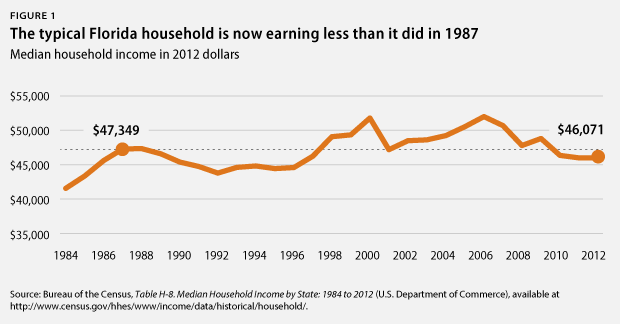
Florida has a lower median household income (and lower levels of education) than the United States average, so that's pretty poor. No?
And as the population booms in Florida, it gets poorer and poorer. I think most of the population growth is from low income people moving out of high cost of living areas.
People who are 65 and older make up almost 20% of Florida's population. The lions share of this group don't work at all, or have very menial jobs while they live off retirement funds. This is going to skew that income statistic a bit. Also you have metro areas like Orlando that have a glut of theme parks and hotels. This industry recruits college age/transient workers and pays them near minimum wage in exchange for work experience, ect. Cruise ship staff's income is counted out of their port of call. These people also get paid lower wages, in exchange for free room and board. This is also going to bring down that Floridian income number. I'm not saying your necessarily wrong, I just think there are too many unique factors in Florida that make that number look artificially lower on paper than it is. I don't think it represents the economic circumstance of a normal (non-transient) Florida resident.
Here's a spreadsheet image I made that basically sums up the biggest pieces of info about the new estimates.
I named the PCSAs after the largest city in their largest constituent metro, for brevity
Thanks for this.
What impresses me the most about your chart is the level of detail and the quality of detail. You're very competent, you even knew to count the 3 extra months (April to July 2010) that most people would have forgotten about when extrapolating data for future terms.
I did the extrapolation of present 5 years and 3 months trends for 2050 and got this (by PCSA);
01. New York: 28,005,382
02. Los Angeles: 23,991,152
03. Washington DC-Baltimore: 13,418,985
04. San Francisco Bay Area: 12,420,525
05. Dallas/Fort Worth Metroplex: 12,050,219
06. Houston: 11,755,479
07. Chicago: 10,466,119
08. Miami/Fort Lauderdale: 9,872,319
09. Boston: 9,865,747
10. Atlanta: 9,375,535
11. Philadelphia: 7,947,772
12. Phoenix: 7,099,047
13. Seattle: 6,772,453
14. Denver: 5,589,082
15. Detroit: 5,325,402
16. Orlando: 5,189,078
17. Minneapolis/Saint Paul: 5,070,368
18. San Diego: 4,651,228
19. Portland: 4,365,172
20. Tampa: 4,244,154
21. San Antonio: 3,982,958
22. Charlotte: 3,960,996
23. Austin: 3,884,273
24. Salt Lake City: 3,765,136
25. Raleigh/Durham: 3,470,617
26. Las Vegas: 3,464,840
27. Sacramento: 3,399,503
28. Cleveland: 3,347,577
29. Columbus: 3,194,439
30. Saint Louis: 3,074,630
31. Indianapolis: 3,072,532
32. Nashville: 3,031,880
33. Kansas City: 2,993,248
Now before people get worked up, I actually don't expect this extrapolation to occur and projecting this far out isn't factual but rather just more fun. They are sort of just estimates using the current track course and applying over a longer period of time. Think of it as one in the same as traffic estimates your GPS system gives you when you're routing directions. The estimated arrival time always changes later on as the situation either clears up or gets worse.
I expect most places (the medium sized ones, I mean) to actually be larger than these numbers with census redefinitions taken into account and for medium sized places like Las Vegas, Austin, San Antonio, and Raleigh/Durham I fully expect their raw number growth to actually go up the bigger they get (similar to what occurred with Dallas, Houston, Phoenix, Miami, and Atlanta -- also what is happening to Orlando right now). So these literally serve as conservative estimates for the medium sized cities, possibly a tad bit optimistic for the really massive cities but fun to look at either way.
For example, Tampa Bay Area will easily be the largest place outside of the estimated top 11, when it will add in Sarasota-North Port CSA, Lakeland MSA, and Homosassa Springs MSA into its area. Cincinnati CSA and Dayton CSA are poised to merge, as are Detroit CSA and Toledo CSA (though later down the line). The San Francisco Bay Area adding in Modesto-Merced and Salinas, Chicagoland adding Rockford and South Bend are also distinct possibilities. Then there are situations that don't exist now but will by 2050 as well.
Last edited by Trafalgar Law; 03-29-2016 at 11:31 AM..
Please register to post and access all features of our very popular forum. It is free and quick. Over $68,000 in prizes has already been given out to active posters on our forum. Additional giveaways are planned.
Detailed information about all U.S. cities, counties, and zip codes on our site: City-data.com.

 Please register to participate in our discussions with 2 million other members - it's free and quick! Some forums can only be seen by registered members. After you create your account, you'll be able to customize options and access all our 15,000 new posts/day with fewer ads.