Please register to participate in our discussions with 2 million other members - it's free and quick! Some forums can only be seen by registered members. After you create your account, you'll be able to customize options and access all our 15,000 new posts/day with fewer ads.
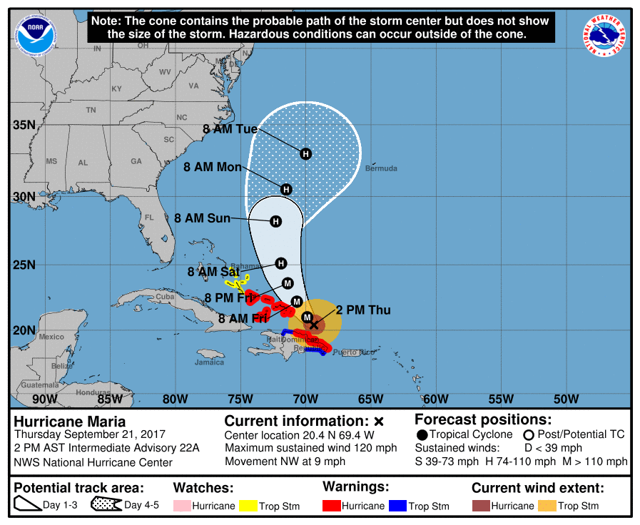
2pmEST/AST: Winds up to 120mph, moving NW 9mph, pressure 960mb, large/wide eye now. Taking advantage of what warm waters irma left behind for next day or so, then shear looks to start steady weakening.
Center currently located about 85miles ENE of Puerto Plata, Dominican Republic, and about 135 miles SE of Grand Turk island. Hurricane force winds extend up to 60miles from center, Tropical Storm winds extend up to 150 miles.
Life threatening rains/flooding/mudslides continues with ADDITIONAL rainfall possible of:
-Puerto Rico: 4-8 inches, isolated max storm totals of 35 inches.
-U.S. and British Virgin Islands: 2-4 inches.
-Northern and eastern Dominican Republic, Turks and Caicos, and Mayaguana in southeast Bahamas: 8-16inches, isolated 20 inches.
-Inagua Islands, Crooked Island, and rest of southeast Bahamas: 4-8 inches.
-Northern Haiti...2 to 4 inches.
49mph wind recently reported in part of Dominican Republic.
Prelim rain totals as of Thursday...Highest thus far listed at 37inches. US National Weather Service San Juan office took an image of their screen and posted this publicly so it's a little blurry:
Seeing some flooding damage in the few pictures of PR that are being circulated in the media. And some Cat 1/2 type damage. But not seeing any pics that show Cat 3/4 WIND damage; no real devastation of 125+ mph winds. Those winds rip roofs off, and all I'm seeing is peeled back -- not even ripped off -- TIN-type roofs. Seeing wood in the street from flooding. Seeing YOUNG trees bent over, electrical lines down. And none of this is Cat 3/4 level damage.
Where are the pics? ANY pics? There should be hundreds/thousands of pics of damage to PR. And still no pics of Dominica except that 3 min flyover by the BBC, where houses were still standing and roofs were intact.
Great video by Bernie as usual! Maria same spot as Irma but different pattern now.
Gulf, Florida, SC safe BUT.... NC to Cape Cod dont hang the towel just yet (in 2-3 days i say you can)
Interesting regarding a weaker trough between the highs if Jose disappears which would allow Maria closer to coast. He reminds us how things can change just days before
Wonder why he didnt think the High wouldnt expand. We'll see. Details details.
Seeing some flooding damage in the few pictures of PR that are being circulated in the media. And some Cat 1/2 type damage. But not seeing any pics that show Cat 3/4 WIND damage; no real devastation of 125+ mph winds. Those winds rip roofs off, and all I'm seeing is peeled back -- not even ripped off -- TIN-type roofs. Seeing wood in the street from flooding. Seeing YOUNG trees bent over, electrical lines down. And none of this is Cat 3/4 level damage.
Where are the pics? ANY pics? There should be hundreds/thousands of pics of damage to PR. And still no pics of Dominica except that 3 min flyover by the BBC, where houses were still standing and roofs were intact.
wtf dude..are you looking for tree limbs through steel doors?
Please register to post and access all features of our very popular forum. It is free and quick. Over $68,000 in prizes has already been given out to active posters on our forum. Additional giveaways are planned.
Detailed information about all U.S. cities, counties, and zip codes on our site: City-data.com.

 Please register to participate in our discussions with 2 million other members - it's free and quick! Some forums can only be seen by registered members. After you create your account, you'll be able to customize options and access all our 15,000 new posts/day with fewer ads.