Bedford, Massachusetts

Submit your own pictures of this town and show them to the world
- OSM Map
- General Map
- Google Map
- MSN Map
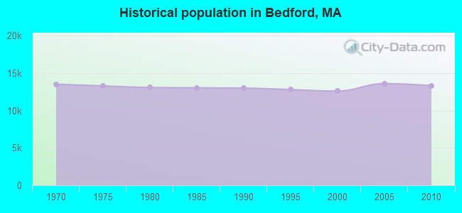
Population change since 2000: +5.8%
 |
| Males: 6,652 | |
| Females: 6,668 |
| Median resident age: | 45.1 years |
| Massachusetts median age: | 39.2 years |
Zip codes: 01730.
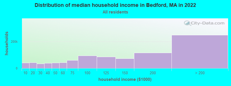
| Bedford: | $171,814 |
| MA: | $94,488 |
Estimated per capita income in 2022: $81,411 (it was $39,212 in 2000)
Bedford town income, earnings, and wages data
Estimated median house or condo value in 2022: $927,379 (it was $328,100 in 2000)
| Bedford: | $927,379 |
| MA: | $534,700 |
Mean prices in 2022: all housing units: $796,617; detached houses: $834,667; townhouses or other attached units: $772,440; in 2-unit structures: $786,250; in 3-to-4-unit structures: $655,835; in 5-or-more-unit structures: $590,321; mobile homes: $144,935
Detailed information about poverty and poor residents in Bedford, MA


- 11,18484.0%White alone
- 1,2509.4%Asian alone
- 3562.7%Hispanic
- 2822.1%Black alone
- 2181.6%Two or more races
- 170.1%American Indian alone
- 100.08%Other race alone
- 30.02%Native Hawaiian and Other
Pacific Islander alone
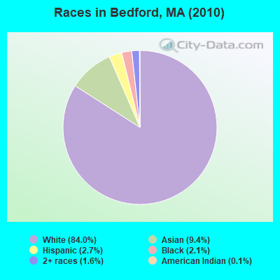
Races in Bedford detailed stats: ancestries, foreign born residents, place of birth
According to our research of Massachusetts and other state lists, there were 6 registered sex offenders living in Bedford, Massachusetts as of April 27, 2024.
The ratio of all residents to sex offenders in Bedford is 2,220 to 1.
The ratio of registered sex offenders to all residents in this city is lower than the state average.
Type |
2009 |
2010 |
2011 |
2012 |
2013 |
2014 |
2015 |
2016 |
2017 |
2018 |
2019 |
2020 |
2021 |
2022 |
|---|---|---|---|---|---|---|---|---|---|---|---|---|---|---|
| Murders (per 100,000) | 0 (0.0) | 0 (0.0) | 0 (0.0) | 0 (0.0) | 0 (0.0) | 1 (7.1) | 0 (0.0) | 0 (0.0) | 0 (0.0) | 0 (0.0) | 0 (0.0) | 0 (0.0) | 0 (0.0) | 0 (0.0) |
| Rapes (per 100,000) | 3 (22.4) | 1 (7.5) | 0 (0.0) | 1 (7.4) | 1 (7.2) | 1 (7.1) | 0 (0.0) | 0 (0.0) | 1 (6.8) | 1 (7.0) | 0 (0.0) | 1 (7.1) | 2 (14.0) | 1 (7.1) |
| Robberies (per 100,000) | 0 (0.0) | 3 (22.5) | 1 (7.5) | 0 (0.0) | 3 (21.5) | 1 (7.1) | 3 (20.8) | 2 (14.0) | 4 (27.4) | 1 (7.0) | 1 (7.0) | 1 (7.1) | 0 (0.0) | 0 (0.0) |
| Assaults (per 100,000) | 5 (37.3) | 7 (52.6) | 4 (29.8) | 6 (44.2) | 2 (14.3) | 4 (28.2) | 5 (34.6) | 4 (28.0) | 4 (27.4) | 5 (34.9) | 6 (42.3) | 9 (63.7) | 2 (14.0) | 1 (7.1) |
| Burglaries (per 100,000) | 16 (119.3) | 30 (225.2) | 32 (238.8) | 19 (140.0) | 11 (78.9) | 6 (42.3) | 15 (103.9) | 4 (28.0) | 9 (61.6) | 9 (62.9) | 2 (14.1) | 12 (84.9) | 10 (70.2) | 10 (71.3) |
| Thefts (per 100,000) | 97 (723.3) | 98 (735.7) | 111 (828.3) | 57 (419.9) | 62 (444.5) | 59 (416.1) | 38 (263.2) | 45 (315.1) | 47 (321.8) | 48 (335.2) | 39 (274.8) | 47 (332.5) | 49 (344.1) | 60 (427.5) |
| Auto thefts (per 100,000) | 4 (29.8) | 2 (15.0) | 1 (7.5) | 1 (7.4) | 1 (7.2) | 2 (14.1) | 3 (20.8) | 0 (0.0) | 3 (20.5) | 1 (7.0) | 1 (7.0) | 4 (28.3) | 2 (14.0) | 2 (14.3) |
| Arson (per 100,000) | 2 (14.9) | 0 (0.0) | 0 (0.0) | 0 (0.0) | 0 (0.0) | 0 (0.0) | 0 (0.0) | 0 (0.0) | 0 (0.0) | 0 (0.0) | 0 (0.0) | 0 (0.0) | 0 (0.0) | 0 (0.0) |
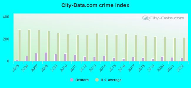
| City-Data.com crime index | 65.0 | 69.7 | 58.7 | 41.9 | 38.9 | 48.2 | 32.6 | 24.4 | 38.0 | 33.0 | 23.1 | 42.0 | 33.8 | 30.4 |
The City-Data.com crime index weighs serious crimes and violent crimes more heavily. Higher means more crime, U.S. average is 246.1. It adjusts for the number of visitors and daily workers commuting into cities.
Crime rate in Bedford detailed stats: murders, rapes, robberies, assaults, burglaries, thefts, arson
Full-time law enforcement employees in 2020, including police officers: 35 (28 officers - 28 male; 0 female).
| Officers per 1,000 residents here: | 1.98 |
| Massachusetts average: | 2.59 |
 Recent articles from our blog. Our writers, many of them Ph.D. graduates or candidates, create easy-to-read articles on a wide variety of topics.

 | What is going on in the Fall River/New Bedford area??? (111 replies) |
| Be careful around the New Bedford Market Basket these days. (51 replies) |
| Another shooting in New Bedford (66 replies) |
| South Coast Rail to New Bedford & Fall River... (20 replies) |
| Gruesome scene in New Bedford (89 replies) |
| Big Dan/New Bedford story (6 replies) |
Latest news from Bedford, MA collected exclusively by city-data.com from local newspapers, TV, and radio stations
Ancestries: Irish (23.2%), Italian (13.9%), English (13.4%), German (11.4%), United States (5.1%), French (4.8%).
Current Local Time: EST time zone
Incorporated in 1729
Elevation: 135 feet
Land area: 13.7 square miles.
Population density: 970 people per square mile (low).
1,216 residents are foreign born (4.3% Asia, 4.1% Europe).
| This town: | 9.7% |
| Massachusetts: | 12.2% |
| Bedford town: | 1.0% ($3,371) |
| Massachusetts: | 1.3% ($2,336) |
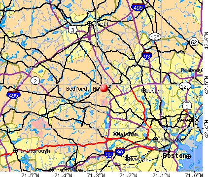
Nearest city with pop. 50,000+: Waltham, MA  (8.3 miles , pop. 59,226).
Nearest city with pop. 200,000+: Boston, MA (15.4 miles , pop. 589,141).
Nearest city with pop. 1,000,000+: Bronx, NY (176.2 miles , pop. 1,332,650).
Nearest cities:
), ), Latitude: 42.50 N, Longitude: 71.28 W

Bedford, Massachusetts accommodation & food services, waste management - Economy and Business Data
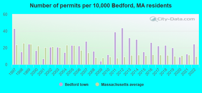
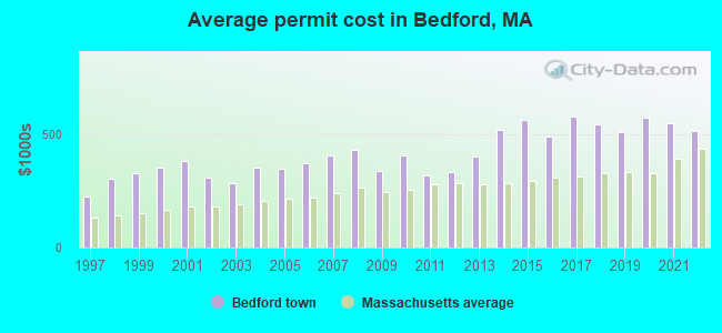
Single-family new house construction building permits:
- 2022: 31 buildings, average cost: $514,300
- 2021: 16 buildings, average cost: $548,200
- 2020: 11 buildings, average cost: $575,300
- 2019: 25 buildings, average cost: $507,400
- 2018: 29 buildings, average cost: $542,700
- 2017: 28 buildings, average cost: $578,300
- 2016: 33 buildings, average cost: $489,700
- 2015: 19 buildings, average cost: $562,500
- 2014: 38 buildings, average cost: $518,000
- 2013: 40 buildings, average cost: $403,700
- 2012: 55 buildings, average cost: $333,200
- 2011: 49 buildings, average cost: $320,400
- 2010: 15 buildings, average cost: $404,700
- 2009: 5 buildings, average cost: $337,100
- 2008: 20 buildings, average cost: $431,100
- 2007: 35 buildings, average cost: $408,400
- 2006: 28 buildings, average cost: $371,000
- 2005: 29 buildings, average cost: $345,900
- 2004: 18 buildings, average cost: $354,300
- 2003: 26 buildings, average cost: $283,100
- 2002: 26 buildings, average cost: $311,300
- 2001: 9 buildings, average cost: $380,000
- 2000: 21 buildings, average cost: $351,800
- 1999: 31 buildings, average cost: $327,300
- 1998: 19 buildings, average cost: $305,900
- 1997: 54 buildings, average cost: $224,000
| Here: | 2.9% |
| Massachusetts: | 3.5% |
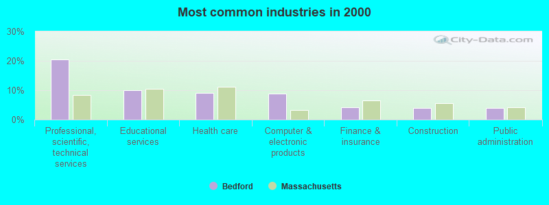
- Professional, scientific, technical services (20.5%)
- Educational services (10.0%)
- Health care (9.0%)
- Computer & electronic products (8.9%)
- Finance & insurance (4.1%)
- Construction (4.0%)
- Public administration (3.9%)
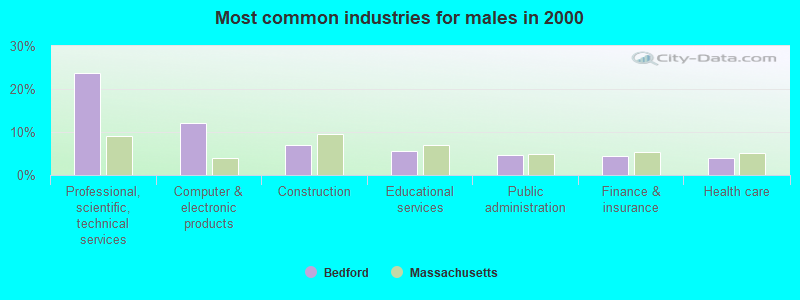
- Professional, scientific, technical services (23.6%)
- Computer & electronic products (12.2%)
- Construction (7.0%)
- Educational services (5.7%)
- Public administration (4.7%)
- Finance & insurance (4.5%)
- Health care (3.9%)
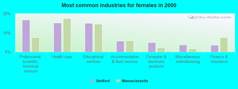
- Professional, scientific, technical services (16.7%)
- Health care (15.2%)
- Educational services (15.1%)
- Accommodation & food services (5.7%)
- Computer & electronic products (4.9%)
- Miscellaneous manufacturing (3.7%)
- Finance & insurance (3.6%)
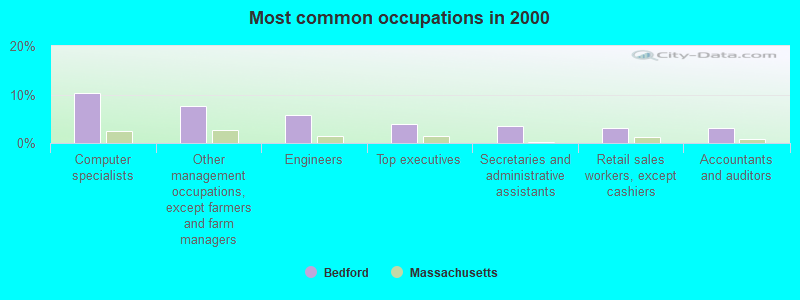
- Computer specialists (10.3%)
- Other management occupations, except farmers and farm managers (7.7%)
- Engineers (5.8%)
- Top executives (4.0%)
- Secretaries and administrative assistants (3.5%)
- Retail sales workers, except cashiers (3.1%)
- Accountants and auditors (3.0%)
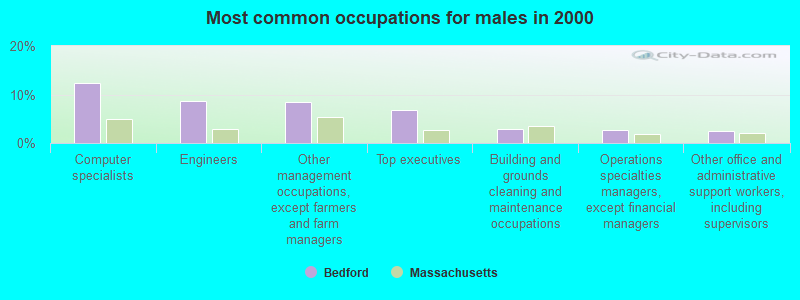
- Computer specialists (12.4%)
- Engineers (8.7%)
- Other management occupations, except farmers and farm managers (8.4%)
- Top executives (6.8%)
- Building and grounds cleaning and maintenance occupations (2.9%)
- Operations specialties managers, except financial managers (2.8%)
- Other office and administrative support workers, including supervisors (2.4%)
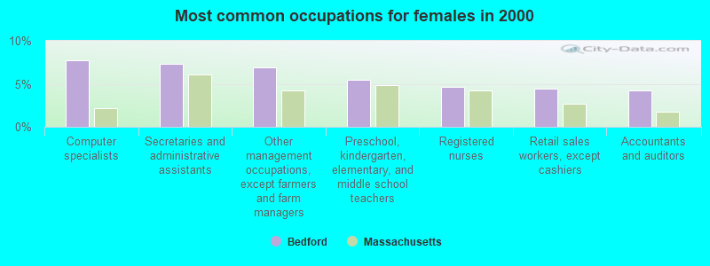
- Computer specialists (7.8%)
- Secretaries and administrative assistants (7.3%)
- Other management occupations, except farmers and farm managers (6.9%)
- Preschool, kindergarten, elementary, and middle school teachers (5.5%)
- Registered nurses (4.7%)
- Retail sales workers, except cashiers (4.5%)
- Accountants and auditors (4.3%)
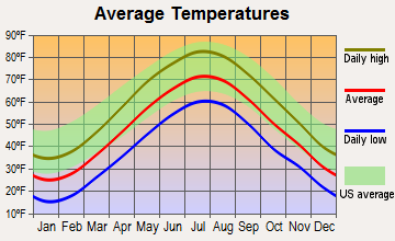
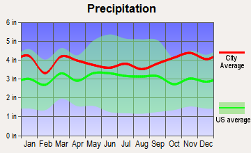
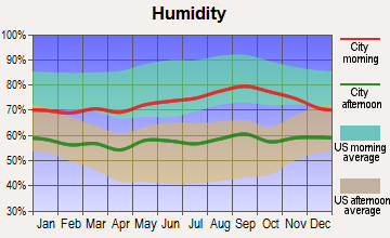
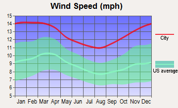
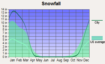
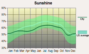
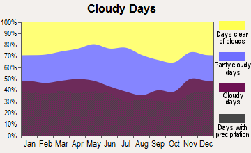
Average climate in Bedford, Massachusetts
Based on data reported by over 4,000 weather stations
(lower is better)
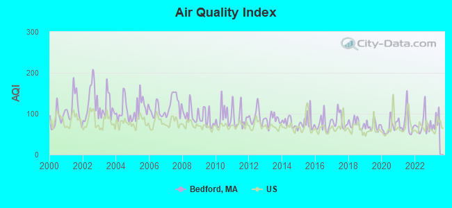
Air Quality Index (AQI) level in 2022 was 74.3. This is about average.
| City: | 74.3 |
| U.S.: | 72.6 |
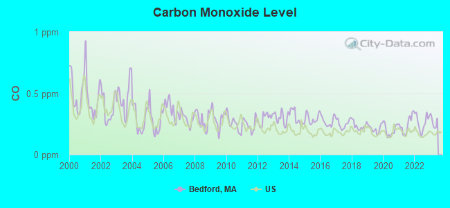
Carbon Monoxide (CO) [ppm] level in 2022 was 0.264. This is about average. Closest monitor was 8.2 miles away from the city center.
| City: | 0.264 |
| U.S.: | 0.251 |
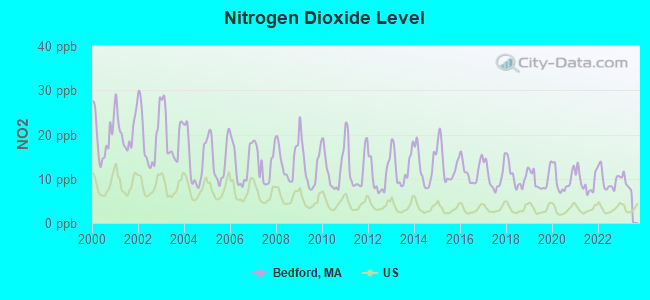
Nitrogen Dioxide (NO2) [ppb] level in 2022 was 9.66. This is significantly worse than average. Closest monitor was 6.4 miles away from the city center.
| City: | 9.66 |
| U.S.: | 5.11 |
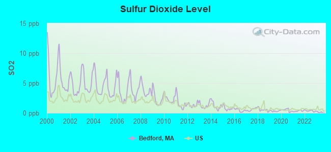
Sulfur Dioxide (SO2) [ppb] level in 2022 was 0.358. This is significantly better than average. Closest monitor was 4.2 miles away from the city center.
| City: | 0.358 |
| U.S.: | 1.515 |

Ozone [ppb] level in 2022 was 26.2. This is better than average. Closest monitor was 1.7 miles away from the city center.
| City: | 26.2 |
| U.S.: | 33.3 |
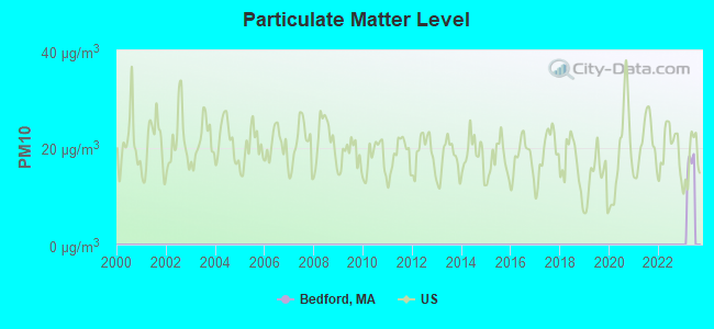
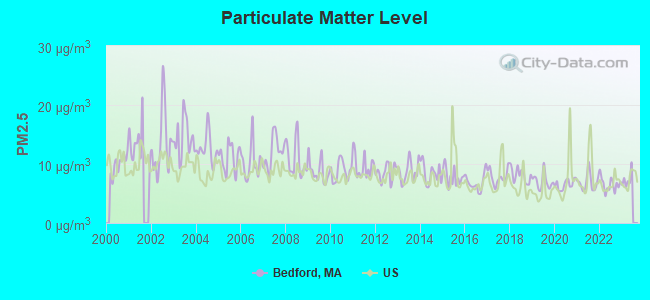
Particulate Matter (PM2.5) [µg/m3] level in 2022 was 6.56. This is better than average. Closest monitor was 8.1 miles away from the city center.
| City: | 6.56 |
| U.S.: | 8.11 |
Tornado activity:
Bedford-area historical tornado activity is near Massachusetts state average. It is 35% smaller than the overall U.S. average.
On 6/9/1953, a category F4 (max. wind speeds 207-260 mph) tornado 18.5 miles away from the Bedford town center killed 90 people and injured 1228 people and caused between $50,000,000 and $500,000,000 in damages.
On 9/29/1974, a category F3 (max. wind speeds 158-206 mph) tornado 7.5 miles away from the town center injured one person and caused between $50,000 and $500,000 in damages.
Earthquake activity:
Bedford-area historical earthquake activity is significantly above Massachusetts state average. It is 73% smaller than the overall U.S. average.On 10/7/1983 at 10:18:46, a magnitude 5.3 (5.1 MB, 5.3 LG, 5.1 ML, Class: Moderate, Intensity: VI - VII) earthquake occurred 184.5 miles away from the city center
On 4/20/2002 at 10:50:47, a magnitude 5.3 (5.3 ML, Depth: 3.0 mi) earthquake occurred 184.9 miles away from Bedford center
On 1/19/1982 at 00:14:42, a magnitude 4.7 (4.5 MB, 4.7 MD, 4.5 LG, Class: Light, Intensity: IV - V) earthquake occurred 71.3 miles away from the city center
On 4/20/2002 at 10:50:47, a magnitude 5.2 (5.2 MB, 4.2 MS, 5.2 MW, 5.0 MW) earthquake occurred 184.3 miles away from the city center
On 10/16/2012 at 23:12:25, a magnitude 4.7 (4.7 ML, Depth: 10.0 mi) earthquake occurred 82.3 miles away from Bedford center
On 8/22/1992 at 12:20:32, a magnitude 4.8 (4.8 MB, 3.8 MS, 4.7 LG, Depth: 6.2 mi) earthquake occurred 239.8 miles away from the city center
Magnitude types: regional Lg-wave magnitude (LG), body-wave magnitude (MB), duration magnitude (MD), local magnitude (ML), surface-wave magnitude (MS), moment magnitude (MW)
Natural disasters:
The number of natural disasters in Middlesex County (31) is a lot greater than the US average (15).Major Disasters (Presidential) Declared: 17
Emergencies Declared: 14
Causes of natural disasters: Floods: 12, Storms: 9, Hurricanes: 6, Snowstorms: 6, Winter Storms: 5, Blizzards: 2, Snows: 2, Explosion: 1, Heavy Rain: 1, Snowfall: 1, Water Main Break: 1, Wind: 1 (Note: some incidents may be assigned to more than one category).

Main business address for: PROGRESS SOFTWARE CORP /MA (SERVICES-PREPACKAGED SOFTWARE), MILLIPORE CORP /MA (LABORATORY ANALYTICAL INSTRUMENTS), MRO SOFTWARE INC (SERVICES-PREPACKAGED SOFTWARE), HOLOGIC INC (X-RAY APPARATUS & TUBES & RELATED IRRADIATION APPARATUS), CAMBRIDGE HEART INC (ELECTROMEDICAL & ELECTROTHERAPEUTIC APPARATUS), INTERACTIVE DATA CORP/MA/ (SECURITY & COMMODITY BROKERS, DEALERS, EXCHANGES & SERVICES), RSA SECURITY INC/DE/ (COMPUTER PERIPHERAL EQUIPMENT, NEC), NITROMED INC (PHARMACEUTICAL PREPARATIONS) and 1 other public companies.
Hospitals and medical centers in Bedford:
Airports located in Bedford:
- Laurence G Hanscom Fld Airport (BED) (Runways: 2, Commercial Ops: 256, Air Taxi Ops: 18,952, Itinerant Ops: 64,211, Local Ops: 50,274, Military Ops: 602)
Amtrak stations near Bedford:
- 7 miles: WOBURN (100 ATLANTIC AVE.) . Services: ticket office.
- 15 miles: BOSTON, NORTH STATION (BOSTON, 126 CAUSEWAY ST.) . Services: ticket office, enclosed waiting area.
- 15 miles: BACK BAY (BOSTON, 145 DARTMOUTH ST.) . Services: ticket office, partially wheelchair accessible, enclosed waiting area, public restrooms, public payphones, vending machines, ATM, paid short-term parking, paid long-term parking, call for car rental service, taxi stand, public transit connection.
Colleges/Universities in Bedford:
Other colleges/universities with over 2000 students near Bedford:
- Bentley University (about 8 miles; Waltham, MA; Full-time enrollment: 5,229)
- Brandeis University (about 10 miles; Waltham, MA; FT enrollment: 6,966)
- Tufts University (about 11 miles; Medford, MA; FT enrollment: 9,041)
- University of Massachusetts-Lowell (about 12 miles; Lowell, MA; FT enrollment: 12,341)
- Lesley University (about 12 miles; Cambridge, MA; FT enrollment: 4,317)
- Harvard University (about 12 miles; Cambridge, MA; FT enrollment: 20,857)
- Cambridge College (about 13 miles; Cambridge, MA; FT enrollment: 2,782)
Public high school in Bedford:
- BEDFORD HIGH (Students: 750, Location: 9 MUDGE WAY, Grades: PK-12)
Private high school in Bedford:
Public elementary/middle schools in Bedford:
- LT JOB LANE SCHOOL (Students: 523, Location: 66 SWEETWATER AVENUE, Grades: 3-5)
- JOHN GLENN MIDDLE (Students: 517, Location: 99 MCMAHON ROAD, Grades: 6-8)
- LT ELEZER DAVIS (Students: 495, Location: 410 DAVIS RD, Grades: KG-2)
- HANSCOM MIDDLE (Location: 6 ENT ROAD, Grades: 4-8)
Library in Bedford:
Points of interest:
Notable locations in Bedford: Boston MedFlight (A), Bedford Fire Department (B), Academic Research Division Library Middlesex Community College (C), Deparment of Veterans Affairs Medical Library (D), Bedford Free Public Library (E), Job Lane Museum (F), Middlesex Community College Library (G). Display/hide their locations on the map
Shopping Centers: The Great Road Shopping Center (1), Bedford Shopping Center (2), Village Shopping Center (3). Display/hide their locations on the map
Main business address in Bedford include: PROGRESS SOFTWARE CORP /MA (A), MILLIPORE CORP /MA (B), MRO SOFTWARE INC (C), HOLOGIC INC (D), CAMBRIDGE HEART INC (E), INTERACTIVE DATA CORP/MA/ (F), RSA SECURITY INC/DE/ (G), NITROMED INC (H). Display/hide their locations on the map
Churches in Bedford include: Immanuel Baptist Church (A), First Baptist Church (B), First Church of Christ (C), Zion Korean Alliance Church (D). Display/hide their locations on the map
Lakes and swamps: Fawn Lake (A), Spectacle Ponds (B), Bedford Meadow (C), Great Meadows (D). Display/hide their locations on the map
Streams, rivers, and creeks: McKee Brook (A), Elm Brook (B), Kiln Brook (C), Mill Brook (D), Spring Brook (E), Beaver Brook (F). Display/hide their locations on the map
Parks in Bedford include: Little Meadow Conservation Area (1), White Cedar Swamp Conservation Area (2), Minnie Reid Conservation Area (3), Bedford Center Historic District (4), Springs Brook Park (5), Elm Brook Conservation Area (6). Display/hide their locations on the map
Hotels: Bedford Travelodge (285 Great Rd), McLaughlin James Associates Inc (4 Bedford Village), Atrium Cafe (340 Great Road), Bedford Motel (30 North Road), Renaissance Boston Bedford Hotel (44 Middlesex Turnpike).
Birthplace of: André Bernier (meteorologist) - Television meteorologist, David Maslanka - Composer, Doug Coombs - Alpine skier, George Earl Church - Civil engineer, Clifford Warren Ashley - Artist, George S. Morison (engineer) - Engineer, I. W. Taber - Photographer, Albert Paine - Writer, Charles Reis Felix - Educator, Ernest C. Torres - Federal judge.
Drinking water stations with addresses in Bedford and their reported violations in the past:
BEDFORD WATER DEPT. (Population served: 13,315, Purch surface water):Past health violations:HARVARD RIDGE CONDOMINIUM (Population served: 350, Groundwater):Past monitoring violations:
- MCL, Monthly (TCR) - In AUG-2014, Contaminant: Coliform. Follow-up actions: St AO (w/o penalty) issued (AUG-07-2014)
- MCL, Monthly (TCR) - In JUL-2014, Contaminant: Coliform. Follow-up actions: St AO (w/o penalty) issued (AUG-07-2014)
- MCL, Monthly (TCR) - In OCT-2013, Contaminant: Coliform. Follow-up actions: St AO (w/o penalty) issued (NOV-13-2013)
- MCL, Monthly (TCR) - In SEP-2013, Contaminant: Coliform. Follow-up actions: St AO (w/o penalty) issued (OCT-04-2013)
- MCL, Monthly (TCR) - In AUG-2013, Contaminant: Coliform. Follow-up actions: St AO (w/o penalty) issued (SEP-06-2013)
- MCL, Monthly (TCR) - In JUL-2013, Contaminant: Coliform. Follow-up actions: St AO (w/o penalty) issued (AUG-05-2013)
- 7 other older health violations
- Notification, State - In OCT-2012, Contaminant: Coliform (TCR). Follow-up actions: St AO (w/o penalty) issued (AUG-31-2012)
- Monitoring and Reporting (DBP) - Between APR-2011 and JUN-2011, Contaminant: TTHM. Follow-up actions: St AO (w/o penalty) issued (AUG-15-2011)
- Monitoring and Reporting (DBP) - Between APR-2011 and JUN-2011, Contaminant: Total Haloacetic Acids (HAA5). Follow-up actions: St AO (w/o penalty) issued (AUG-15-2011)
- Monitoring and Reporting (DBP) - Between JAN-2011 and MAR-2011, Contaminant: TTHM. Follow-up actions: St AO (w/o penalty) issued (APR-27-2011)
- Monitoring and Reporting (DBP) - Between JAN-2011 and MAR-2011, Contaminant: Total Haloacetic Acids (HAA5). Follow-up actions: St AO (w/o penalty) issued (APR-27-2011)
- One routine major monitoring violation
- One minor monitoring violation
- 47 regular monitoring violations
- 2 other older monitoring violations
Past health violations:400 DUNSTABLE ROAD (PINE KNOLL) (Population served: 30, Groundwater):Past monitoring violations:
- MCL, Monthly (TCR) - In OCT-2011, Contaminant: Coliform. Follow-up actions: St AO (w/o penalty) issued (FEB-08-2012)
- 2 routine major monitoring violations
Past monitoring violations:
- 26 regular monitoring violations
| This town: | 2.5 people |
| Massachusetts: | 2.5 people |
| This town: | 70.5% |
| Whole state: | 63.0% |
| This town: | 3.5% |
| Whole state: | 7.0% |
Likely homosexual households (counted as self-reported same-sex unmarried-partner households)
- Lesbian couples: 0.4% of all households
- Gay men: 0.1% of all households
| This town: | 2.5% |
| Whole state: | 9.3% |
| This town: | 0.7% |
| Whole state: | 4.4% |
People in group quarters in Bedford in 2010:
- 256 people in nursing facilities/skilled-nursing facilities
- 110 people in military barracks and dormitories (nondisciplinary)
- 60 people in mental (psychiatric) hospitals and psychiatric units in other hospitals
- 40 people in hospitals with patients who have no usual home elsewhere
- 24 people in group homes intended for adults
- 9 people in in-patient hospice facilities
- 8 people in other noninstitutional facilities
People in group quarters in Bedford in 2000:
- 509 people in nursing homes
- 41 people in other nonhousehold living situations
- 21 people in military transient quarters for temporary residents
- 8 people in military disciplinary barracks
- 7 people in homes for the mentally retarded
- 3 people in religious group quarters
Banks with branches in Bedford (2011 data):
- RBS Citizens, National Association: Bedford Stop & Shop Branch at 337 Great Road, branch established on 2002/04/17; Bedford Branch at 287 Great Road, branch established on 1993/07/16. Info updated 2007/09/19: Bank assets: $106,940.6 mil, Deposits: $75,690.2 mil, headquarters in Providence, RI, positive income, 1135 total offices, Holding Company: Uk Financial Investments Limited
- Bank of America, National Association: Old Billerica Road Branch at 100 Old Billerica Road, branch established on 1992/03/17; Bedford Branch at 152 Great Road, branch established on 1981/01/12. Info updated 2009/11/18: Bank assets: $1,451,969.3 mil, Deposits: $1,077,176.8 mil, headquarters in Charlotte, NC, positive income, 5782 total offices, Holding Company: Bank Of America Corporation
- Middlesex Savings Bank: Bedford Branch at 186 Great Road, branch established on 2006/08/14. Info updated 2009/07/16: Bank assets: $4,034.8 mil, Deposits: $3,490.0 mil, headquarters in Natick, MA, positive income, Mortgage Lending Specialization, 33 total offices, Holding Company: Middlesex Bancorp Mhc
- Cambridge Savings Bank: Bedford Branch at 181 Great Road, branch established on 1955/09/07. Info updated 2007/01/05: Bank assets: $2,316.4 mil, Deposits: $1,902.8 mil, headquarters in Cambridge, MA, positive income, Commercial Lending Specialization, 18 total offices, Holding Company: Cambridge Financial Group, Inc.
- Sovereign Bank, National Association: Bedford Branch at 94 Great Road, branch established on 1947/11/20. Info updated 2012/01/31: Bank assets: $78,146.9 mil, Deposits: $48,042.9 mil, headquarters in Wilmington, DE, positive income, Commercial Lending Specialization, 718 total offices, Holding Company: Banco Santander, S.A.
- TD Bank, National Association: Bedford Branch at 175 The Great Road, branch established on 1916/01/01. Info updated 2010/10/04: Bank assets: $188,912.6 mil, Deposits: $153,149.8 mil, headquarters in Wilmington, DE, positive income, 1314 total offices, Holding Company: Toronto-Dominion Bank, The
- Brookline Bank: Bedford Branch at 168 Great Road, branch established on 2002/06/03. Info updated 2011/07/21: Bank assets: $2,854.7 mil, Deposits: $2,040.1 mil, headquarters in Brookline, MA, positive income, Commercial Lending Specialization, 20 total offices, Holding Company: Brookline Bancorp, Inc.
For population 15 years and over in Bedford:
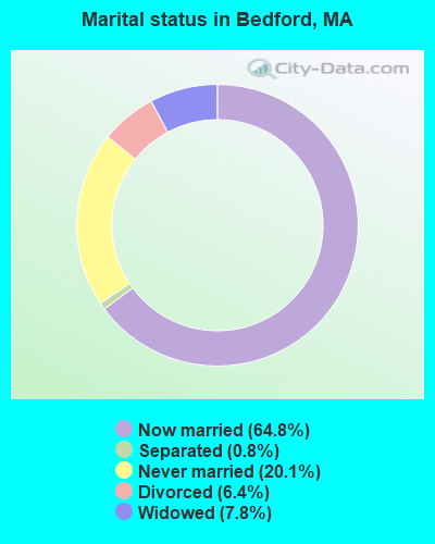
- Never married: 20.1%
- Now married: 64.8%
- Separated: 0.8%
- Widowed: 7.8%
- Divorced: 6.4%
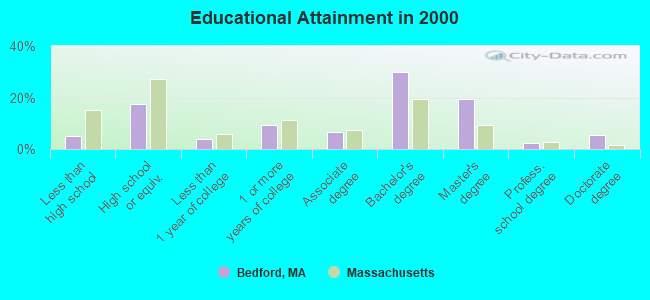
For population 25 years and over in Bedford:
- High school or higher: 94.9%
- Bachelor's degree or higher: 57.4%
- Graduate or professional degree: 27.3%
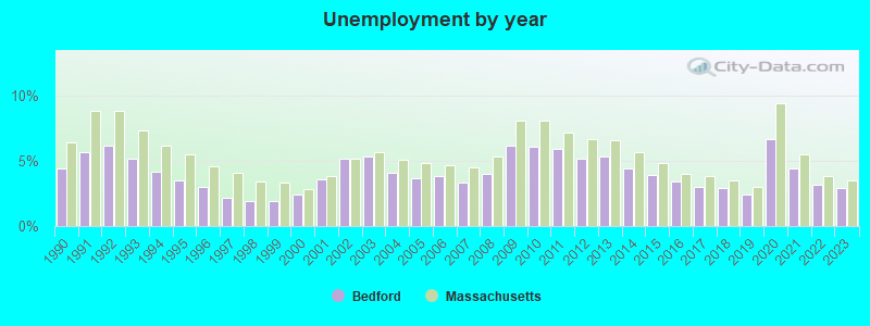
- Unemployed: 2.3%
- Mean travel time to work (commute): 24.3 minutes
| Here: | 10.7 |
| Massachusetts average: | 13.1 |


Graphs represent county-level data. Detailed 2008 Election Results
Religion statistics for Bedford, MA (based on Middlesex County data)


| Religion | Adherents | Congregations |
|---|---|---|
| Catholic | 718,209 | 107 |
| Mainline Protestant | 70,053 | 269 |
| Other | 68,480 | 199 |
| Evangelical Protestant | 41,270 | 304 |
| Orthodox | 23,641 | 28 |
| Black Protestant | 2,276 | 8 |
| None | 579,156 | - |
Food Environment Statistics:
| Middlesex County: | 1.71 / 10,000 pop. |
| Massachusetts: | 1.98 / 10,000 pop. |
| This county: | 0.03 / 10,000 pop. |
| State: | 0.05 / 10,000 pop. |
| Middlesex County: | 2.14 / 10,000 pop. |
| Massachusetts: | 2.22 / 10,000 pop. |
| Middlesex County: | 1.38 / 10,000 pop. |
| State: | 1.77 / 10,000 pop. |
| Here: | 7.84 / 10,000 pop. |
| State: | 8.76 / 10,000 pop. |
| This county: | 7.8% |
| Massachusetts: | 8.1% |
| Middlesex County: | 21.5% |
| Massachusetts: | 22.5% |
| This county: | 18.0% |
| State: | 16.5% |
6.91% of this county's 2021 resident taxpayers lived in other counties in 2020 ($102,955 average adjusted gross income)
| Here: | 6.91% |
| Massachusetts average: | 6.35% |
0.01% of residents moved from foreign countries ($137 average AGI)
Middlesex County: 0.01% Massachusetts average: 0.01%
Top counties from which taxpayers relocated into this county between 2020 and 2021:
| from Suffolk County, MA | |
| from Essex County, MA | |
| from Norfolk County, MA |
8.22% of this county's 2020 resident taxpayers moved to other counties in 2021 ($123,369 average adjusted gross income)
| Here: | 8.22% |
| Massachusetts average: | 7.18% |
0.01% of residents moved to foreign countries ($124 average AGI)
Middlesex County: 0.01% Massachusetts average: 0.02%
Top counties to which taxpayers relocated from this county between 2020 and 2021:
| to Suffolk County, MA | |
| to Essex County, MA | |
| to Worcester County, MA |
| Businesses in Bedford, MA | ||||
| Name | Count | Name | Count | |
|---|---|---|---|---|
| Ace Hardware | 1 | Quiznos | 1 | |
| CVS | 1 | RadioShack | 1 | |
| Domino's Pizza | 1 | Staples | 1 | |
| Dunkin Donuts | 4 | Starbucks | 1 | |
| FedEx | 7 | Stop & Shop | 1 | |
| GNC | 1 | T.J.Maxx | 1 | |
| H&R Block | 1 | Travelodge | 1 | |
| Hilton | 1 | UPS | 4 | |
| Marshalls | 1 | Volkswagen | 1 | |
| McDonald's | 1 | Whole Foods Market | 1 | |
Strongest AM radio stations in Bedford:
- WRKO (680 AM; 50 kW; BOSTON, MA; Owner: ENTERCOM BOSTON LICENSE, LLC)
- WWZN (1510 AM; 50 kW; BOSTON, MA; Owner: ROSE CITY RADIO CORPORATION)
- WEEI (850 AM; 50 kW; BOSTON, MA; Owner: ENTERCOM BOSTON LICENSE, LLC)
- WRCA (1330 AM; 25 kW; WALTHAM, MA; Owner: WRCA LICENSE, LLC)
- WKOX (1200 AM; 50 kW; FRAMINGHAM, MA; Owner: CAPSTAR TX LIMITED PARTNERSHIP)
- WBIX (1060 AM; 40 kW; NATICK, MA; Owner: LANGER BROADCASTING CORPORATION)
- WBPS (1150 AM; 5 kW; BOSTON, MA; Owner: MEGA COMMUNICATIONS OF BOSTON LICENSEE, L.L.C.)
- WAMG (890 AM; 25 kW; DEDHAM, MA; Owner: MEGA COMMUNICATIONS OF DEDHAM LICENSEE, LLC)
- WBZ (1030 AM; 50 kW; BOSTON, MA; Owner: INFINITY BROADCASTING OPERATIONS, INC.)
- WNTN (1550 AM; 10 kW; NEWTON, MA; Owner: COLT COMMUNICATIONS, LLC)
- WBNW (1120 AM; 5 kW; CONCORD, MA; Owner: MONEY MATTERS RADIO, INC.)
- WEZE (590 AM; 5 kW; BOSTON, MA; Owner: NEW ENGLAND CONTINENTAL MEDIA, INC.)
- WUNR (1600 AM; 20 kW; BROOKLINE, MA; Owner: CHAMPION BROADCASTING SYSTEMS, INC.)
Strongest FM radio stations in Bedford:
- WBMX (98.5 FM; BOSTON, MA; Owner: INFINITY RADIO OPERATIONS INC.)
- WJMN (94.5 FM; BOSTON, MA; Owner: AMFM RADIO LICENSES, L.L.C.)
- WCRB (102.5 FM; WALTHAM, MA; Owner: CHARLES RIVER BROADCASTING WCRB LICE)
- WTKK (96.9 FM; BOSTON, MA; Owner: GREATER BOSTON RADIO, INC.)
- WROR-FM (105.7 FM; FRAMINGHAM, MA; Owner: GREATER BOSTON RADIO, INC.)
- WBOS (92.9 FM; BROOKLINE, MA; Owner: GREATER BOSTON RADIO, INC.)
- WXKS-FM (107.9 FM; MEDFORD, MA; Owner: AMFM RADIO LICENSES, L.L.C.)
- WGBH (89.7 FM; BOSTON, MA; Owner: WGBH EDUCATIONAL FOUNDATION)
- WMJX (106.7 FM; BOSTON, MA; Owner: GREATER BOSTON RADIO, INC.)
- WBUR-FM (90.9 FM; BOSTON, MA; Owner: TRUSTEES OF BOSTON UNIVERSITY)
- WODS (103.3 FM; BOSTON, MA; Owner: INFINITY BROADCASTING OPERATIONS, INC.)
- WKLB-FM (99.5 FM; LOWELL, MA; Owner: GREATER BOSTON RADIO, INC.)
- W227AM (93.3 FM; ANDOVER, MA; Owner: GREATER BOSTON RADIO, INC.)
- WBCN (104.1 FM; BOSTON, MA; Owner: HEMISPHERE BROADCASTING CORPORATION)
- WZLX (100.7 FM; BOSTON, MA; Owner: INFINITY BROADCASTING CORPORATION OF BOSTON)
- W267AI (101.3 FM; BOSTON, MA; Owner: MCC BROADCASTING COMPANY, INC.)
- WERS (88.9 FM; BOSTON, MA; Owner: EMERSON COLLEGE)
- WFNX (101.7 FM; LYNN, MA; Owner: MCC BROADCASTING COMPANY, INC.)
- WQSX (93.7 FM; LAWRENCE, MA; Owner: ENTERCOM BOSTON LICENSE, LLC)
- WHRB (95.3 FM; CAMBRIDGE, MA; Owner: HARVARD RADIO BROADCASTING CO., INC.)
TV broadcast stations around Bedford:
- WCVB-TV (Channel 5; BOSTON, MA; Owner: WCVB HEARST-ARGYLE TV, INC.)
- WGBH-TV (Channel 2; BOSTON, MA; Owner: WGBH EDUCATIONAL FOUNDATION)
- WHDH-TV (Channel 7; BOSTON, MA; Owner: WHDH-TV)
- WMFP (Channel 62; LAWRENCE, MA; Owner: WSAH LICENSE, INC.)
- WBZ-TV (Channel 4; BOSTON, MA; Owner: VIACOM INC.)
- WGBX-TV (Channel 44; BOSTON, MA; Owner: WGBH EDUCATIONAL FOUNDATION)
- WSBK-TV (Channel 38; BOSTON, MA; Owner: VIACOM INC.)
- WLVI-TV (Channel 56; CAMBRIDGE, MA; Owner: WLVI, INC.)
- WUTF (Channel 66; MARLBOROUGH, MA; Owner: TELEFUTURA BOSTON LLC)
- WFXT (Channel 25; BOSTON, MA; Owner: FOX TELEVISION STATIONS INC.)
- WBPX (Channel 68; BOSTON, MA; Owner: PAXSON BOSTON-68 LICENSE, INC.)
- W40BO (Channel 40; BOSTON, MA; Owner: PAXSON COMMUNICATIONS LPTV, INC.)
- WTMU-LP (Channel 32; BOSTON, MA; Owner: ZGS BOSTON, INC.)
- WCEA-LP (Channel 58; BOSTON, MA; Owner: CHANNEL 19 TV CORPORATION)
- WFXZ-CA (Channel 24; BOSTON, MA; Owner: BOSTON BROADCASTING CORP.)
- WUNI (Channel 27; WORCESTER, MA; Owner: ENTRAVISION HOLDINGS, LLC)
- WNDS (Channel 50; DERRY, NH; Owner: CTV OF DERRY, INC)
- WWDP (Channel 46; NORWELL, MA; Owner: NORWELL TELEVISION, LLC)
- WHDN-LP (Channel 26; BOSTON, MA; Owner: GUENTER MARKSTEINER)
- WNAC-TV (Channel 64; PROVIDENCE, RI; Owner: WNAC, LLC)
- WLNE-TV (Channel 6; NEW BEDFORD, MA; Owner: FREEDOM BROADCASTING OF SOUTHERN NEW ENGLAND, INC.)
- WPRI-TV (Channel 12; PROVIDENCE, RI; Owner: TVL BROADCASTING OF RHODE ISLAND, LLC)
- National Bridge Inventory (NBI) Statistics
- 11Number of bridges
- 105ft / 32.4mTotal length
- $13,485,000Total costs
- 275,932Total average daily traffic
- 23,606Total average daily truck traffic
- 455,513Total future (year 2031) average daily traffic
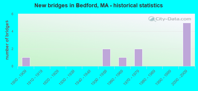
- New bridges - historical statistics
- 11900-1909
- 21950-1959
- 11960-1969
- 21970-1979
- 52000-2009
FCC Registered Private Land Mobile Towers: 1 (See the full list of FCC Registered Private Land Mobile Towers in Bedford, MA)
FCC Registered Broadcast Land Mobile Towers: 14 (See the full list of FCC Registered Broadcast Land Mobile Towers)
FCC Registered Microwave Towers: 12 (See the full list of FCC Registered Microwave Towers in this town)
FCC Registered Paging Towers: 1 (See the full list of FCC Registered Paging Towers)
FCC Registered Maritime Coast & Aviation Ground Towers: 18 (See the full list of FCC Registered Maritime Coast & Aviation Ground Towers)
FCC Registered Amateur Radio Licenses: 142 (See the full list of FCC Registered Amateur Radio Licenses in Bedford)
FAA Registered Aircraft Manufacturers and Dealers: 8 (See the full list of FAA Registered Manufacturers and Dealers in Bedford)
FAA Registered Aircraft: 34 (See the full list of FAA Registered Aircraft)
2002 - 2018 National Fire Incident Reporting System (NFIRS) incidents
- Fire incident types reported to NFIRS in Bedford, MA
- 23345.4%Structure Fires
- 20439.8%Outside Fires
- 6612.9%Mobile Property/Vehicle Fires
- 101.9%Other
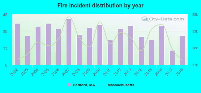 Based on the data from the years 2002 - 2018 the average number of fire incidents per year is 30. The highest number of reported fires - 41 took place in 2007, and the least - 13 in 2017. The data has a decreasing trend.
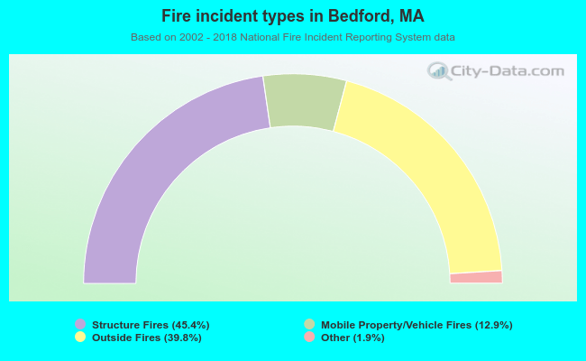 When looking into fire subcategories, the most reports belonged to: Structure Fires (45.4%), and Outside Fires (39.8%).
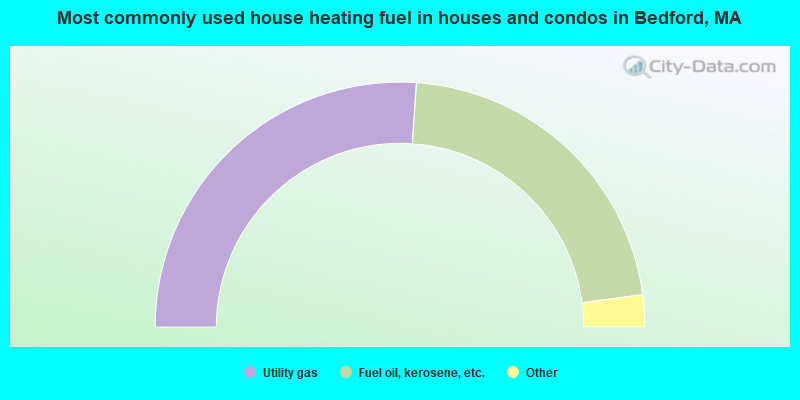
- 52.2%Utility gas
- 43.7%Fuel oil, kerosene, etc.
- 3.3%Electricity
- 0.6%Other fuel
- 0.2%Wood
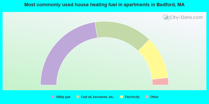
- 45.2%Utility gas
- 29.4%Fuel oil, kerosene, etc.
- 21.6%Electricity
- 1.3%Bottled, tank, or LP gas
- 1.2%Other fuel
- 1.2%No fuel used
Bedford compared to Massachusetts state average:
- Median household income above state average.
- Median house value above state average.
- Unemployed percentage significantly below state average.
- Black race population percentage significantly below state average.
- Hispanic race population percentage significantly below state average.
- Median age above state average.
- Foreign-born population percentage below state average.
- Length of stay since moving in significantly above state average.
- Number of rooms per house significantly below state average.
- House age significantly below state average.
- Institutionalized population percentage above state average.
- Number of college students below state average.
- Percentage of population with a bachelor's degree or higher above state average.
Bedford on our top lists:
- #2 on the list of "Top 101 cities with largest percentage of females in occupations: computer specialists (population 5,000+)"
- #6 on the list of "Top 101 cities with largest percentage of females in occupations: engineers (population 5,000+)"
- #8 on the list of "Top 101 cities with largest percentage of females in occupations: accountants and auditors (population 5,000+)"
- #8 on the list of "Top 101 cities with largest percentage of males in occupations: social scientists and related workers (population 5,000+)"
- #11 on the list of "Top 101 cities with largest percentage of males in occupations: computer specialists (population 5,000+)"
- #14 on the list of "Top 101 cities with largest percentage of males in occupations: business operations specialists (population 5,000+)"
- #17 on the list of "Top 101 cities with the largest percentage of people in military disciplinary barracks (population 1,000+)"
- #19 on the list of "Top 101 cities with largest percentage of females in industries: radio, tv, and computer stores (population 5,000+)"
- #24 on the list of "Top 101 cities with largest percentage of males in industries: computer and electronic products (population 5,000+)"
- #33 on the list of "Top 101 cities with the largest city-data.com crime index increase from 2002 to 2012 (population 5,000+)"
- #36 on the list of "Top 101 cities with largest percentage of females in industries: data processing, libraries, and other information services (population 5,000+)"
- #38 on the list of "Top 101 cities with largest percentage of males in industries: publishing, and motion picture and sound recording industries (population 5,000+)"
- #45 on the list of "Top 101 cities with the largest percentage of people in military transient quarters for temporary residents (population 1,000+)"
- #50 on the list of "Top 101 cities with largest percentage of females in industries: miscellaneous manufacturing (population 5,000+)"
- #56 on the list of "Top 101 cities with largest percentage of females in industries: computer and electronic products (population 5,000+)"
- #99 on the list of "Top 101 cities with the smallest city-data.com crime index per police officer (population 5,000+)"
- #99 on the list of "Top 101 cities with the lowest number of thefts per 100,000 residents (population 5,000+)"
- #4 on the list of "Top 101 counties with the most Orthodox adherents"
- #7 on the list of "Top 101 counties with the most Catholic adherents"
- #7 on the list of "Top 101 counties with the most Mainline Protestant congregations"
- #7 on the list of "Top 101 counties with the most Orthodox congregations"
- #8 on the list of "Top 101 counties with the lowest percentage of residents that keep firearms around their homes"

|
|
Total of 1973 patent applications in 2008-2024.