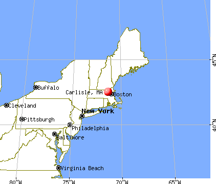
Carlisle, Massachusetts
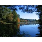
Submit your own pictures of this town and show them to the world
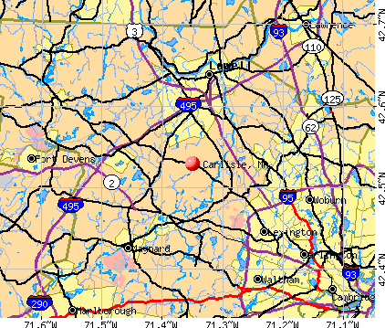
- OSM Map
- General Map
- Google Map
- MSN Map
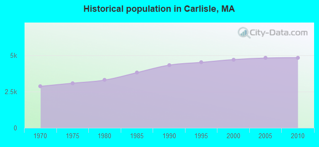
Population change since 2000: +2.9%
 |
| Males: 2,416 | |
| Females: 2,436 |
| Median resident age: | 46.9 years |
| Massachusetts median age: | 39.2 years |
Zip codes: 01741.
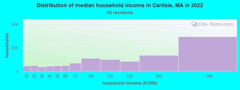
| Carlisle: | over $200,000 |
| MA: | $94,488 |
Estimated per capita income in 2022: $123,656 (it was $59,559 in 2000)
Carlisle town income, earnings, and wages data
Estimated median house or condo value in 2022: over $1,000,000 (it was $457,800 in 2000)
| Carlisle: | over $1,000,000 |
| MA: | $534,700 |
Mean prices in 2022: all housing units: $796,617; detached houses: $834,667; townhouses or other attached units: $772,440; in 2-unit structures: $786,250; in 3-to-4-unit structures: $655,835; in 5-or-more-unit structures: $590,321; mobile homes: $144,935
Detailed information about poverty and poor residents in Carlisle, MA


- 4,25787.7%White alone
- 3807.8%Asian alone
- 1002.1%Hispanic
- 891.8%Two or more races
- 140.3%Black alone
- 100.2%Other race alone
- 10.02%American Indian alone
- 10.02%Native Hawaiian and Other
Pacific Islander alone
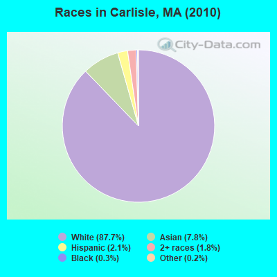
Races in Carlisle detailed stats: ancestries, foreign born residents, place of birth
According to our research of Massachusetts and other state lists, there was 1 registered sex offender living in Carlisle, Massachusetts as of April 27, 2024.
The ratio of all residents to sex offenders in Carlisle is 4,852 to 1.
The ratio of registered sex offenders to all residents in this city is much lower than the state average.
Type |
2009 |
2010 |
2011 |
2012 |
2013 |
2014 |
2015 |
2016 |
2017 |
2018 |
2019 |
2020 |
2021 |
2022 |
|---|---|---|---|---|---|---|---|---|---|---|---|---|---|---|
| Murders (per 100,000) | 0 (0.0) | 0 (0.0) | 0 (0.0) | 0 (0.0) | 0 (0.0) | 0 (0.0) | 0 (0.0) | 0 (0.0) | 0 (0.0) | 0 (0.0) | 0 (0.0) | 0 (0.0) | 0 (0.0) | 0 (0.0) |
| Rapes (per 100,000) | 0 (0.0) | 2 (41.2) | 0 (0.0) | 0 (0.0) | 0 (0.0) | 0 (0.0) | 1 (19.5) | 0 (0.0) | 1 (18.8) | 1 (18.9) | 1 (19.0) | 0 (0.0) | 1 (18.8) | 1 (19.4) |
| Robberies (per 100,000) | 0 (0.0) | 0 (0.0) | 0 (0.0) | 0 (0.0) | 0 (0.0) | 0 (0.0) | 0 (0.0) | 1 (18.9) | 0 (0.0) | 0 (0.0) | 0 (0.0) | 0 (0.0) | 0 (0.0) | 0 (0.0) |
| Assaults (per 100,000) | 1 (20.1) | 1 (20.6) | 0 (0.0) | 0 (0.0) | 0 (0.0) | 0 (0.0) | 0 (0.0) | 0 (0.0) | 2 (37.6) | 0 (0.0) | 0 (0.0) | 1 (19.0) | 1 (18.8) | 1 (19.4) |
| Burglaries (per 100,000) | 12 (241.3) | 9 (185.5) | 12 (245.8) | 2 (40.4) | 4 (79.5) | 4 (78.7) | 3 (58.5) | 1 (18.9) | 2 (37.6) | 4 (75.6) | 4 (76.1) | 1 (19.0) | 2 (37.7) | 1 (19.4) |
| Thefts (per 100,000) | 7 (140.8) | 4 (82.4) | 7 (143.4) | 7 (141.5) | 3 (59.7) | 6 (118.0) | 20 (390.2) | 22 (415.1) | 9 (169.4) | 19 (359.2) | 18 (342.5) | 13 (246.8) | 23 (433.0) | 3 (58.3) |
| Auto thefts (per 100,000) | 1 (20.1) | 0 (0.0) | 0 (0.0) | 0 (0.0) | 0 (0.0) | 0 (0.0) | 0 (0.0) | 0 (0.0) | 0 (0.0) | 0 (0.0) | 0 (0.0) | 0 (0.0) | 1 (18.8) | 0 (0.0) |
| Arson (per 100,000) | 0 (0.0) | 0 (0.0) | 0 (0.0) | 0 (0.0) | 0 (0.0) | 0 (0.0) | 1 (19.5) | 0 (0.0) | 0 (0.0) | 0 (0.0) | 0 (0.0) | 0 (0.0) | 0 (0.0) | 0 (0.0) |
| City-Data.com crime index | 28.2 | 53.4 | 22.9 | 8.5 | 8.0 | 10.2 | 35.3 | 23.6 | 32.0 | 34.8 | 34.3 | 15.0 | 40.3 | 23.1 |
The City-Data.com crime index weighs serious crimes and violent crimes more heavily. Higher means more crime, U.S. average is 246.1. It adjusts for the number of visitors and daily workers commuting into cities.
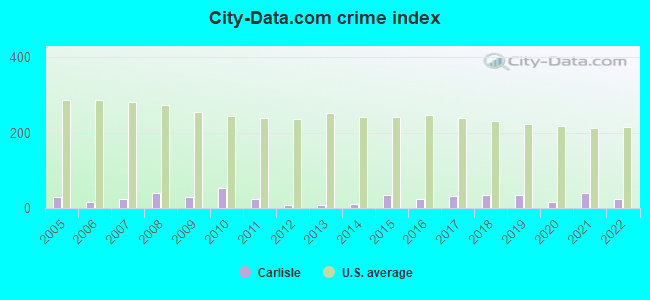
Crime rate in Carlisle detailed stats: murders, rapes, robberies, assaults, burglaries, thefts, arson
Full-time law enforcement employees in 2021, including police officers: 15 (10 officers - 9 male; 1 female).
| Officers per 1,000 residents here: | 1.88 |
| Massachusetts average: | 2.53 |
 Recent articles from our blog. Our writers, many of them Ph.D. graduates or candidates, create easy-to-read articles on a wide variety of topics.

 | Michelle Wu Rent Control Proposal (leaked) via Boston Globe (119 replies) |
| Feedback on Carlisle, MA for young families (1 reply) |
| Boston Racial Stigma- is it "cool" to hate on Boston? (632 replies) |
| Why is BPS so bad and what should be done to improve it? (589 replies) |
| Mayor Walsh tapped for Labor Secretary (1240 replies) |
| Which towns should we consider? (35 replies) |
Latest news from Carlisle, MA collected exclusively by city-data.com from local newspapers, TV, and radio stations
Carlisle, MA City Guides:
Ancestries: English (19.4%), Irish (16.5%), German (12.8%), Italian (9.5%), French (5.7%), Russian (4.7%).
Current Local Time: EST time zone
Incorporated in 1780
Elevation: 205 feet
Land area: 15.4 square miles.
Population density: 316 people per square mile (very low).
568 residents are foreign born (6.1% Europe, 3.2% Asia, 2.1% North America).
| This town: | 12.0% |
| Massachusetts: | 12.2% |
| Carlisle town: | 1.3% ($6,018) |
| Massachusetts: | 1.3% ($2,336) |
Nearest city with pop. 50,000+: Lowell, MA  (7.9 miles , pop. 105,167).
Nearest city with pop. 200,000+: Boston, MA (19.6 miles , pop. 589,141).
Nearest city with pop. 1,000,000+: Bronx, NY (174.6 miles , pop. 1,332,650).
Nearest cities:
), ), ), Latitude: 42.53 N, Longitude: 71.35 W
Area code commonly used in this area: 978

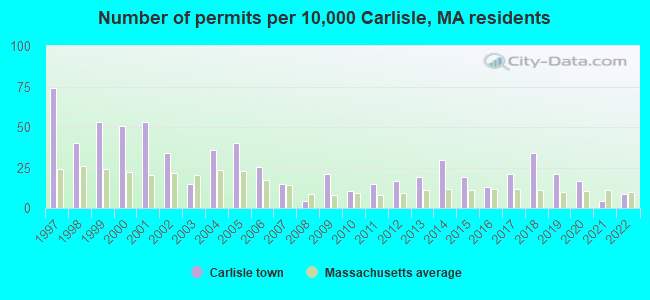
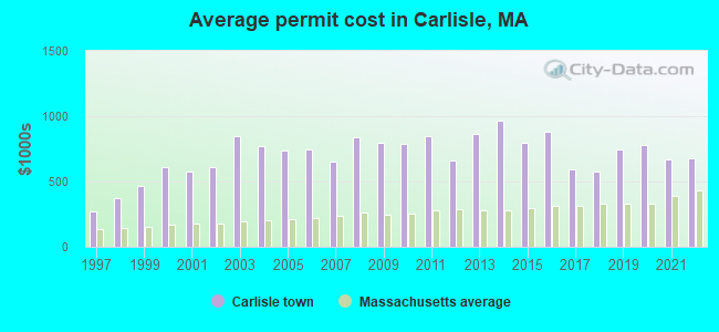
Single-family new house construction building permits:
- 2022: 4 buildings, average cost: $675,000
- 2021: 2 buildings, average cost: $670,500
- 2020: 8 buildings, average cost: $779,100
- 2019: 10 buildings, average cost: $741,900
- 2018: 16 buildings, average cost: $579,700
- 2017: 10 buildings, average cost: $595,800
- 2016: 6 buildings, average cost: $879,300
- 2015: 9 buildings, average cost: $795,600
- 2014: 14 buildings, average cost: $969,000
- 2013: 9 buildings, average cost: $864,700
- 2012: 8 buildings, average cost: $660,700
- 2011: 7 buildings, average cost: $844,600
- 2010: 5 buildings, average cost: $790,900
- 2009: 10 buildings, average cost: $793,400
- 2008: 2 buildings, average cost: $841,400
- 2007: 7 buildings, average cost: $652,200
- 2006: 12 buildings, average cost: $742,400
- 2005: 19 buildings, average cost: $736,300
- 2004: 17 buildings, average cost: $774,000
- 2003: 7 buildings, average cost: $844,600
- 2002: 16 buildings, average cost: $609,800
- 2001: 25 buildings, average cost: $572,900
- 2000: 24 buildings, average cost: $609,600
- 1999: 25 buildings, average cost: $465,300
- 1998: 19 buildings, average cost: $375,800
- 1997: 35 buildings, average cost: $273,000
| Here: | 3.0% |
| Massachusetts: | 3.5% |
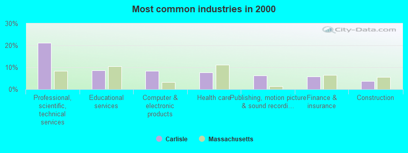
- Professional, scientific, technical services (21.2%)
- Educational services (8.7%)
- Computer & electronic products (8.4%)
- Health care (7.7%)
- Publishing, motion picture & sound recording industries (6.3%)
- Finance & insurance (5.7%)
- Construction (3.8%)
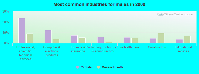
- Professional, scientific, technical services (23.8%)
- Computer & electronic products (12.3%)
- Finance & insurance (7.4%)
- Publishing, motion picture & sound recording industries (6.0%)
- Health care (5.7%)
- Construction (4.6%)
- Educational services (3.7%)
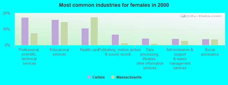
- Professional, scientific, technical services (17.3%)
- Educational services (16.0%)
- Health care (10.7%)
- Publishing, motion picture & sound recording industries (6.8%)
- Data processing, libraries, other information services (4.3%)
- Administrative & support & waste management services (4.1%)
- Social assistance (3.9%)
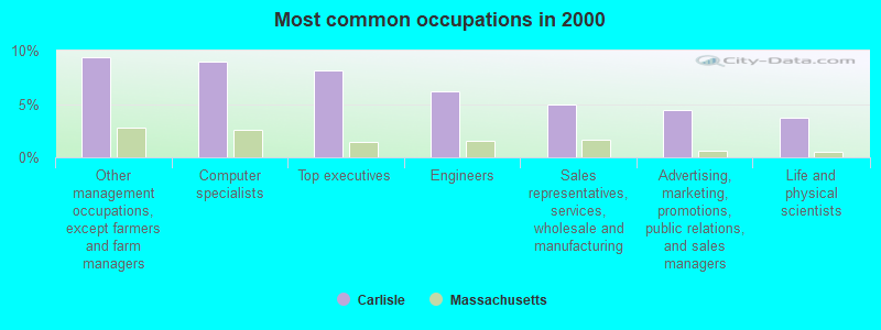
- Other management occupations, except farmers and farm managers (9.4%)
- Computer specialists (9.0%)
- Top executives (8.1%)
- Engineers (6.2%)
- Sales representatives, services, wholesale and manufacturing (4.9%)
- Advertising, marketing, promotions, public relations, and sales managers (4.4%)
- Life and physical scientists (3.8%)
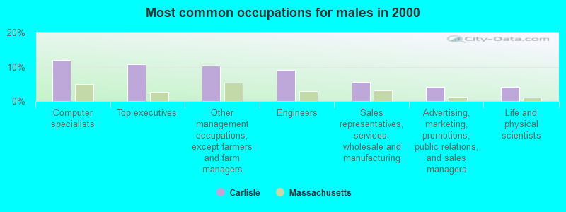
- Computer specialists (12.0%)
- Top executives (10.7%)
- Other management occupations, except farmers and farm managers (10.3%)
- Engineers (9.0%)
- Sales representatives, services, wholesale and manufacturing (5.7%)
- Advertising, marketing, promotions, public relations, and sales managers (4.2%)
- Life and physical scientists (4.0%)
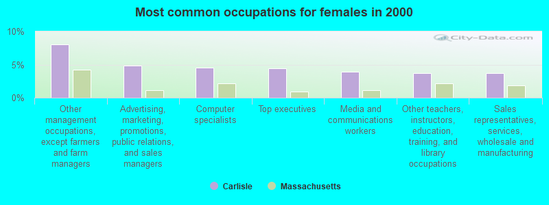
- Other management occupations, except farmers and farm managers (8.0%)
- Advertising, marketing, promotions, public relations, and sales managers (4.8%)
- Computer specialists (4.5%)
- Top executives (4.4%)
- Media and communications workers (3.9%)
- Other teachers, instructors, education, training, and library occupations (3.8%)
- Sales representatives, services, wholesale and manufacturing (3.8%)
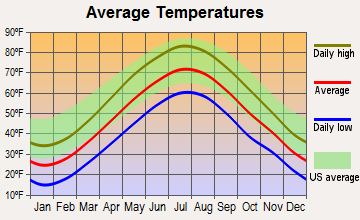
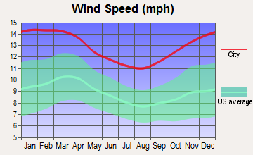
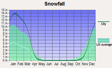
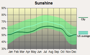
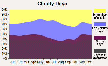
Average climate in Carlisle, Massachusetts
Based on data reported by over 4,000 weather stations
(lower is better)
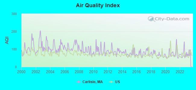
Air Quality Index (AQI) level in 2022 was 74.3. This is about average.
| City: | 74.3 |
| U.S.: | 72.6 |
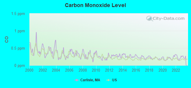
Carbon Monoxide (CO) [ppm] level in 2022 was 0.230. This is about average. Closest monitor was 8.4 miles away from the city center.
| City: | 0.230 |
| U.S.: | 0.251 |
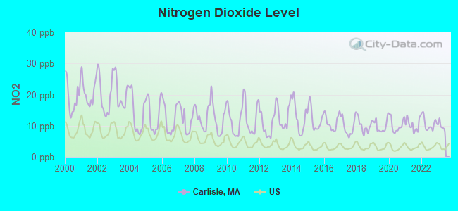
Nitrogen Dioxide (NO2) [ppb] level in 2022 was 10.6. This is significantly worse than average. Closest monitor was 6.2 miles away from the city center.
| City: | 10.6 |
| U.S.: | 5.1 |
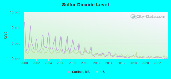
Sulfur Dioxide (SO2) [ppb] level in 2022 was 0.351. This is significantly better than average. Closest monitor was 4.2 miles away from the city center.
| City: | 0.351 |
| U.S.: | 1.515 |
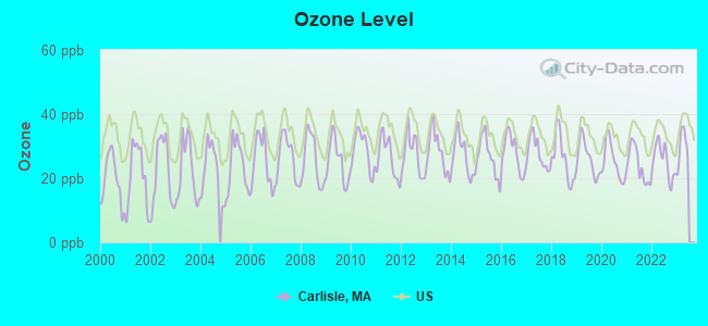
Ozone [ppb] level in 2022 was 25.4. This is better than average. Closest monitor was 6.0 miles away from the city center.
| City: | 25.4 |
| U.S.: | 33.3 |
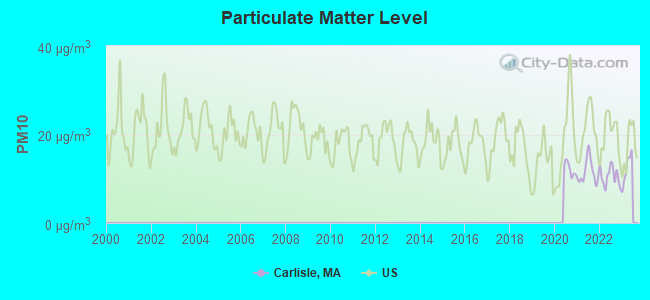
Particulate Matter (PM10) [µg/m3] level in 2022 was 10.6. This is significantly better than average. Closest monitor was 6.8 miles away from the city center.
| City: | 10.6 |
| U.S.: | 19.2 |
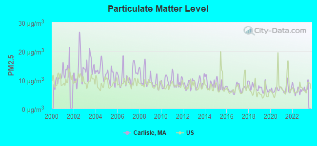
Particulate Matter (PM2.5) [µg/m3] level in 2022 was 6.42. This is better than average. Closest monitor was 6.2 miles away from the city center.
| City: | 6.42 |
| U.S.: | 8.11 |
Tornado activity:
Carlisle-area historical tornado activity is slightly above Massachusetts state average. It is 32% smaller than the overall U.S. average.
On 6/9/1953, a category F4 (max. wind speeds 207-260 mph) tornado 18.0 miles away from the Carlisle town center killed 90 people and injured 1228 people and caused between $50,000,000 and $500,000,000 in damages.
On 9/29/1974, a category F3 (max. wind speeds 158-206 mph) tornado 7.9 miles away from the town center injured one person and caused between $50,000 and $500,000 in damages.
Earthquake activity:
Carlisle-area historical earthquake activity is significantly above Massachusetts state average. It is 72% smaller than the overall U.S. average.On 10/7/1983 at 10:18:46, a magnitude 5.3 (5.1 MB, 5.3 LG, 5.1 ML, Class: Moderate, Intensity: VI - VII) earthquake occurred 180.0 miles away from Carlisle center
On 4/20/2002 at 10:50:47, a magnitude 5.3 (5.3 ML, Depth: 3.0 mi) earthquake occurred 180.8 miles away from the city center
On 1/19/1982 at 00:14:42, a magnitude 4.7 (4.5 MB, 4.7 MD, 4.5 LG, Class: Light, Intensity: IV - V) earthquake occurred 68.4 miles away from Carlisle center
On 4/20/2002 at 10:50:47, a magnitude 5.2 (5.2 MB, 4.2 MS, 5.2 MW, 5.0 MW) earthquake occurred 180.1 miles away from Carlisle center
On 10/16/2012 at 23:12:25, a magnitude 4.7 (4.7 ML, Depth: 10.0 mi) earthquake occurred 81.8 miles away from the city center
On 8/22/1992 at 12:20:32, a magnitude 4.8 (4.8 MB, 3.8 MS, 4.7 LG, Depth: 6.2 mi) earthquake occurred 242.8 miles away from the city center
Magnitude types: regional Lg-wave magnitude (LG), body-wave magnitude (MB), duration magnitude (MD), local magnitude (ML), surface-wave magnitude (MS), moment magnitude (MW)
Natural disasters:
The number of natural disasters in Middlesex County (31) is a lot greater than the US average (15).Major Disasters (Presidential) Declared: 17
Emergencies Declared: 14
Causes of natural disasters: Floods: 12, Storms: 9, Hurricanes: 6, Snowstorms: 6, Winter Storms: 5, Blizzards: 2, Snows: 2, Explosion: 1, Heavy Rain: 1, Snowfall: 1, Water Main Break: 1, Wind: 1 (Note: some incidents may be assigned to more than one category).

Hospitals and medical centers near Carlisle:
- BEDFORD VA MEDICAL CENTER (Hospital, Acute Care - Veterans Administration, about 5 miles away; BEDFORD, MA)
- SUNNY ACRES NURSING HOME (Nursing Home, about 5 miles away; CHELMSFORD, MA)
- SUBURBAN MANOR CONV AND NURSING HOME (Nursing Home, about 5 miles away; ACTON, MA)
- SIMMONS NURSING HOME, INC (Nursing Home, about 5 miles away; BILLERICA, MA)
- WESTFORD HOUSE (Nursing Home, about 5 miles away; WESTFORD, MA)
- ACTON PUBLIC HEALTH NURSING SE (Home Health Center, about 6 miles away; ACTON, MA)
- CARLETON-WILLARD VILLAGE NSG CENTER (Nursing Home, about 6 miles away; BEDFORD, MA)
Amtrak stations near Carlisle:
- 11 miles: WOBURN (100 ATLANTIC AVE.) . Services: ticket office.
- 18 miles: FRAMINGHAM (443 WAVERLY ST.) . Services: public payphones, snack bar, paid short-term parking, taxi stand, public transit connection.
- 19 miles: BOSTON, NORTH STATION (BOSTON, 126 CAUSEWAY ST.) . Services: ticket office, enclosed waiting area.
Colleges/universities with over 2000 students nearest to Carlisle:
- Middlesex Community College (about 4 miles; Bedford, MA; Full-time enrollment: 6,040)
- University of Massachusetts-Lowell (about 9 miles; Lowell, MA; FT enrollment: 12,341)
- Bentley University (about 12 miles; Waltham, MA; FT enrollment: 5,229)
- Brandeis University (about 13 miles; Waltham, MA; FT enrollment: 6,966)
- Tufts University (about 15 miles; Medford, MA; FT enrollment: 9,041)
- Merrimack College (about 16 miles; North Andover, MA; FT enrollment: 2,734)
- Massachusetts Bay Community College (about 16 miles; Wellesley Hills, MA; FT enrollment: 3,636)
Public elementary/middle school in Carlisle:
- CARLISLE SCHOOL (Students: 785, Location: 83 SCHOOL STREET, Grades: PK-8)
Library in Carlisle:
Points of interest:
Notable locations in Carlisle: Carlisle Town Hall (A), Carlisle Fire Department (B), Ruth C Wilkins Library (C), Gleason Public Library (D). Display/hide their locations on the map
Churches in Carlisle include: Saint Irene Catholic Church (A), Carlisle Congregational Church (B). Display/hide their locations on the map
Cemetery: Green Cemetery (1). Display/hide its location on the map
Lakes, reservoirs, and swamps: Buttrick Pond (A), Greenough Pond (B), Cranberry Bog Reservoir Number One (C), Iron Ore Swamp (D), Tophet Swamp (E). Display/hide their locations on the map
Park in Carlisle: Carlisle State Forest (1). Display/hide its location on the map
Hotel: Bed Rose Inn (99 Nickles Lane).
| This town: | 2.9 people |
| Massachusetts: | 2.5 people |
| This town: | 85.1% |
| Whole state: | 63.0% |
| This town: | 3.1% |
| Whole state: | 7.0% |
Likely homosexual households (counted as self-reported same-sex unmarried-partner households)
- Lesbian couples: 0.8% of all households
- Gay men: 0.4% of all households
| This town: | 2.4% |
| Whole state: | 9.3% |
| This town: | 0.7% |
| Whole state: | 4.4% |
For population 15 years and over in Carlisle:
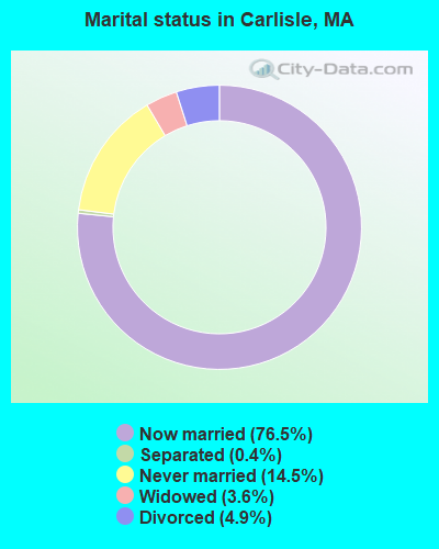
- Never married: 14.5%
- Now married: 76.5%
- Separated: 0.4%
- Widowed: 3.6%
- Divorced: 4.9%
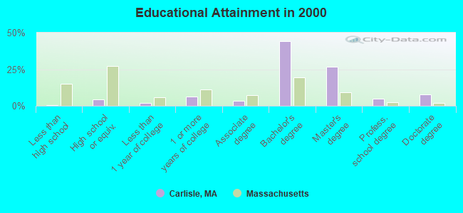
For population 25 years and over in Carlisle:
- High school or higher: 99.4%
- Bachelor's degree or higher: 83.4%
- Graduate or professional degree: 39.1%
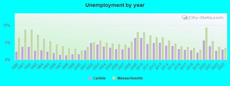
- Unemployed: 0.7%
- Mean travel time to work (commute): 32.7 minutes
| Here: | 7.3 |
| Massachusetts average: | 13.1 |


Graphs represent county-level data. Detailed 2008 Election Results
Religion statistics for Carlisle, MA (based on Middlesex County data)


| Religion | Adherents | Congregations |
|---|---|---|
| Catholic | 718,209 | 107 |
| Mainline Protestant | 70,053 | 269 |
| Other | 68,480 | 199 |
| Evangelical Protestant | 41,270 | 304 |
| Orthodox | 23,641 | 28 |
| Black Protestant | 2,276 | 8 |
| None | 579,156 | - |
Food Environment Statistics:
| Here: | 1.71 / 10,000 pop. |
| State: | 1.98 / 10,000 pop. |
| Here: | 0.03 / 10,000 pop. |
| State: | 0.05 / 10,000 pop. |
| Middlesex County: | 2.14 / 10,000 pop. |
| Massachusetts: | 2.22 / 10,000 pop. |
| Middlesex County: | 1.38 / 10,000 pop. |
| Massachusetts: | 1.77 / 10,000 pop. |
| This county: | 7.84 / 10,000 pop. |
| Massachusetts: | 8.76 / 10,000 pop. |
| This county: | 7.8% |
| State: | 8.1% |
| Middlesex County: | 21.5% |
| Massachusetts: | 22.5% |
| Here: | 18.0% |
| Massachusetts: | 16.5% |
6.91% of this county's 2021 resident taxpayers lived in other counties in 2020 ($102,955 average adjusted gross income)
| Here: | 6.91% |
| Massachusetts average: | 6.35% |
0.01% of residents moved from foreign countries ($137 average AGI)
Middlesex County: 0.01% Massachusetts average: 0.01%
Top counties from which taxpayers relocated into this county between 2020 and 2021:
| from Suffolk County, MA | |
| from Essex County, MA | |
| from Norfolk County, MA |
8.22% of this county's 2020 resident taxpayers moved to other counties in 2021 ($123,369 average adjusted gross income)
| Here: | 8.22% |
| Massachusetts average: | 7.18% |
0.01% of residents moved to foreign countries ($124 average AGI)
Middlesex County: 0.01% Massachusetts average: 0.02%
Top counties to which taxpayers relocated from this county between 2020 and 2021:
| to Suffolk County, MA | |
| to Essex County, MA | |
| to Worcester County, MA |
Businesses in Carlisle, MA
- FedEx: 1
Strongest AM radio stations in Carlisle:
- WRKO (680 AM; 50 kW; BOSTON, MA; Owner: ENTERCOM BOSTON LICENSE, LLC)
- WWZN (1510 AM; 50 kW; BOSTON, MA; Owner: ROSE CITY RADIO CORPORATION)
- WEEI (850 AM; 50 kW; BOSTON, MA; Owner: ENTERCOM BOSTON LICENSE, LLC)
- WKOX (1200 AM; 50 kW; FRAMINGHAM, MA; Owner: CAPSTAR TX LIMITED PARTNERSHIP)
- WBIX (1060 AM; 40 kW; NATICK, MA; Owner: LANGER BROADCASTING CORPORATION)
- WRCA (1330 AM; 25 kW; WALTHAM, MA; Owner: WRCA LICENSE, LLC)
- WBNW (1120 AM; 5 kW; CONCORD, MA; Owner: MONEY MATTERS RADIO, INC.)
- WAMG (890 AM; 25 kW; DEDHAM, MA; Owner: MEGA COMMUNICATIONS OF DEDHAM LICENSEE, LLC)
- WCAP (980 AM; 5 kW; LOWELL, MA; Owner: NORTHEAST RADIO, INC.)
- WBZ (1030 AM; 50 kW; BOSTON, MA; Owner: INFINITY BROADCASTING OPERATIONS, INC.)
- WCRN (830 AM; 50 kW; WORCESTER, MA; Owner: CARTER BROADCASTING CORPORATION)
- WNTN (1550 AM; 10 kW; NEWTON, MA; Owner: COLT COMMUNICATIONS, LLC)
- WBPS (1150 AM; 5 kW; BOSTON, MA; Owner: MEGA COMMUNICATIONS OF BOSTON LICENSEE, L.L.C.)
Strongest FM radio stations in Carlisle:
- WBMX (98.5 FM; BOSTON, MA; Owner: INFINITY RADIO OPERATIONS INC.)
- WJMN (94.5 FM; BOSTON, MA; Owner: AMFM RADIO LICENSES, L.L.C.)
- WCRB (102.5 FM; WALTHAM, MA; Owner: CHARLES RIVER BROADCASTING WCRB LICE)
- WTKK (96.9 FM; BOSTON, MA; Owner: GREATER BOSTON RADIO, INC.)
- WKLB-FM (99.5 FM; LOWELL, MA; Owner: GREATER BOSTON RADIO, INC.)
- WROR-FM (105.7 FM; FRAMINGHAM, MA; Owner: GREATER BOSTON RADIO, INC.)
- WBOS (92.9 FM; BROOKLINE, MA; Owner: GREATER BOSTON RADIO, INC.)
- WGBH (89.7 FM; BOSTON, MA; Owner: WGBH EDUCATIONAL FOUNDATION)
- WXKS-FM (107.9 FM; MEDFORD, MA; Owner: AMFM RADIO LICENSES, L.L.C.)
- WBUR-FM (90.9 FM; BOSTON, MA; Owner: TRUSTEES OF BOSTON UNIVERSITY)
- WMJX (106.7 FM; BOSTON, MA; Owner: GREATER BOSTON RADIO, INC.)
- W227AM (93.3 FM; ANDOVER, MA; Owner: GREATER BOSTON RADIO, INC.)
- WODS (103.3 FM; BOSTON, MA; Owner: INFINITY BROADCASTING OPERATIONS, INC.)
- WBCN (104.1 FM; BOSTON, MA; Owner: HEMISPHERE BROADCASTING CORPORATION)
- WZLX (100.7 FM; BOSTON, MA; Owner: INFINITY BROADCASTING CORPORATION OF BOSTON)
- WHOB (106.3 FM; NASHUA, NH; Owner: TELE-MEDIA COMPANY OF NEW HAMPSHIRE, L.L.C.)
- W267AI (101.3 FM; BOSTON, MA; Owner: MCC BROADCASTING COMPANY, INC.)
- WERS (88.9 FM; BOSTON, MA; Owner: EMERSON COLLEGE)
- WQSX (93.7 FM; LAWRENCE, MA; Owner: ENTERCOM BOSTON LICENSE, LLC)
- WFNX (101.7 FM; LYNN, MA; Owner: MCC BROADCASTING COMPANY, INC.)
TV broadcast stations around Carlisle:
- WUTF (Channel 66; MARLBOROUGH, MA; Owner: TELEFUTURA BOSTON LLC)
- WCVB-TV (Channel 5; BOSTON, MA; Owner: WCVB HEARST-ARGYLE TV, INC.)
- WGBH-TV (Channel 2; BOSTON, MA; Owner: WGBH EDUCATIONAL FOUNDATION)
- WHDH-TV (Channel 7; BOSTON, MA; Owner: WHDH-TV)
- WMFP (Channel 62; LAWRENCE, MA; Owner: WSAH LICENSE, INC.)
- WBZ-TV (Channel 4; BOSTON, MA; Owner: VIACOM INC.)
- WGBX-TV (Channel 44; BOSTON, MA; Owner: WGBH EDUCATIONAL FOUNDATION)
- WSBK-TV (Channel 38; BOSTON, MA; Owner: VIACOM INC.)
- WLVI-TV (Channel 56; CAMBRIDGE, MA; Owner: WLVI, INC.)
- WFXT (Channel 25; BOSTON, MA; Owner: FOX TELEVISION STATIONS INC.)
- WBPX (Channel 68; BOSTON, MA; Owner: PAXSON BOSTON-68 LICENSE, INC.)
- WFXZ-CA (Channel 24; BOSTON, MA; Owner: BOSTON BROADCASTING CORP.)
- W40BO (Channel 40; BOSTON, MA; Owner: PAXSON COMMUNICATIONS LPTV, INC.)
- WUNI (Channel 27; WORCESTER, MA; Owner: ENTRAVISION HOLDINGS, LLC)
- WTMU-LP (Channel 32; BOSTON, MA; Owner: ZGS BOSTON, INC.)
- WCEA-LP (Channel 58; BOSTON, MA; Owner: CHANNEL 19 TV CORPORATION)
- WNDS (Channel 50; DERRY, NH; Owner: CTV OF DERRY, INC)
- WWDP (Channel 46; NORWELL, MA; Owner: NORWELL TELEVISION, LLC)
- WHDN-LP (Channel 26; BOSTON, MA; Owner: GUENTER MARKSTEINER)
- National Bridge Inventory (NBI) Statistics
- 3Number of bridges
- 13ft / 4.1mTotal length
- $2,278,000Total costs
- 7,661Total average daily traffic
- 532Total average daily truck traffic
- 14,213Total future (year 2031) average daily traffic
FCC Registered Antenna Towers:
23 (See the full list of FCC Registered Antenna Towers in Carlisle)FCC Registered Broadcast Land Mobile Towers:
8 (See the full list of FCC Registered Broadcast Land Mobile Towers in Carlisle, MA)FCC Registered Paging Towers:
2- 82 Mcallister Drive (Lat: 42.546667 Lon: -71.318889), Type: Tower, Structure height: 24.4 m, Overall height: 27.7 m, Call Sign: KNKK744,
Assigned Frequencies: 931.812 MHz, Grant Date: 05/11/1999, Expiration Date: 04/01/2009, Cancellation Date: 05/23/2009, Certifier: Shawn E Endsley, Registrant: Usa Mobility Wireless, Inc., 300 Technology Drive #400, Plano, TX 75074, Phone: (972) 801-1626, Fax: (972) 801-1699, Email:
- 82 Mcallister Drive (Lat: 42.546667 Lon: -71.318889), Type: Tower, Structure height: 24.4 m, Overall height: 27.7 m, Call Sign: KNKE429, Licensee ID: L01422065,
Assigned Frequencies: 931.187 MHz, Grant Date: 05/05/2009, Expiration Date: 04/01/2019, Cancellation Date: 07/21/2010, Certifier: Shawn E Endsley, Registrant: Usa Mobility Wireless, Inc., 3000 Technology Dr. #400, Plano, TX 75074, Phone: (972) 801-0000, Email:
FCC Registered Amateur Radio Licenses:
76 (See the full list of FCC Registered Amateur Radio Licenses in Carlisle)FAA Registered Aircraft:
7- Aircraft: BEECH 35-A33 (Category: Land, Seats: 4, Weight: Up to 12,499 Pounds, Speed: 138 mph), Engine: CONT MOTOR I0-470 SERIES (260 HP) (Reciprocating)
N-Number: 1277Z, N1277Z, N-1277Z, Serial Number: CD-342, Year manufactured: 1961, Airworthiness Date: 05/04/1961, Certificate Issue Date: 10/03/2002
Registrant (Individual): David F Kitrosser, 788 Lowell Rd, Carlisle, MA 01741 - Aircraft: EXTRA FLUGZEUGBAU GMBH EA 300/L (Category: Land, Seats: 2, Weight: Up to 12,499 Pounds), Engine: LYCOMING AEIO-540 SER (260 HP) (Reciprocating)
N-Number: 184ST, N184ST, N-184ST, Serial Number: 1199, Year manufactured: 2005, Airworthiness Date: 08/09/2005, Certificate Issue Date: 10/18/2016
Registrant (Individual): David C Shaver, 123 Carlisle Pines Dr, Carlisle, MA 01741 - Aircraft: PIPER PA-28-151 (Category: Land, Seats: 4, Weight: Up to 12,499 Pounds, Speed: 80 mph), Engine: LYCOMING 0-320 SERIES (180 HP) (Reciprocating)
N-Number: 6940J, N6940J, N-6940J, Serial Number: 28-7615404, Year manufactured: 1976, Certificate Issue Date: 09/13/1976
Registrant (Co-Owned): Michael L Reisch, 53 Nathan Lane, Carlisle, MA 01741, Other Owners: Ileana S Reisch - Aircraft: BEECH A36 (Category: Land, Seats: 6, Weight: Up to 12,499 Pounds, Speed: 138 mph), Engine: CONT MOTOR IO-550 SERIES (300 HP) (Reciprocating)
N-Number: 8140G, N8140G, N-8140G, Serial Number: E-2635, Year manufactured: 1991, Airworthiness Date: 06/11/1991, Certificate Issue Date: 03/20/2014
Registrant (Individual): J Kevin Mcnamara, 20 Estabrook Rd, Carlisle, MA 01741 - Aircraft: CESSNA 182T (Category: Land, Seats: 4, Weight: Up to 12,499 Pounds), Engine: LYCOMING IO-540-AB1A5 (230 HP) (Reciprocating)
N-Number: 91160, N91160, N-91160, Serial Number: 18282297, Year manufactured: 2011, Airworthiness Date: 08/24/2011, Certificate Issue Date: 08/25/2016
Registrant (Individual): Jeffrey C Brown, 146 Davis Rd, Carlisle, MA 01741 - Aircraft: BEECH V35 (Category: Land, Seats: 6, Weight: Up to 12,499 Pounds, Speed: 150 mph), Engine: CONT MOTOR IO 520 SERIES (285 HP) (Reciprocating)
N-Number: 9598V, N9598V, N-9598V, Serial Number: D-8115, Year manufactured: 1966, Airworthiness Date: 03/28/1966, Certificate Issue Date: 04/24/1990
Registrant (Individual): William K Jr Tee, 216 River Rd, Carlisle, MA 01741 - Aircraft: CESSNA 177RG (Category: Land, Seats: 4, Weight: Up to 12,499 Pounds, Speed: 120 mph), Engine: LYCOMING IO-360-A1B6D (200 HP) (Reciprocating)
N-Number: 52926, N52926, N-52926, Serial Number: 177RG1311, Year manufactured: 1978, Airworthiness Date: 02/03/1978, Certificate Issue Date: 04/29/1997
Registrant (Individual): Christopher Kiley, 50 Long Ridge Rd, Carlisle, MA 01741
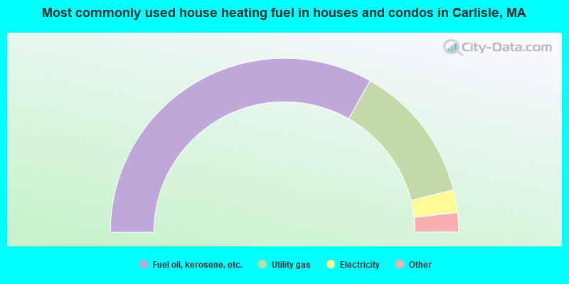
- 66.4%Fuel oil, kerosene, etc.
- 25.8%Utility gas
- 4.2%Electricity
- 3.1%Bottled, tank, or LP gas
- 0.5%Wood
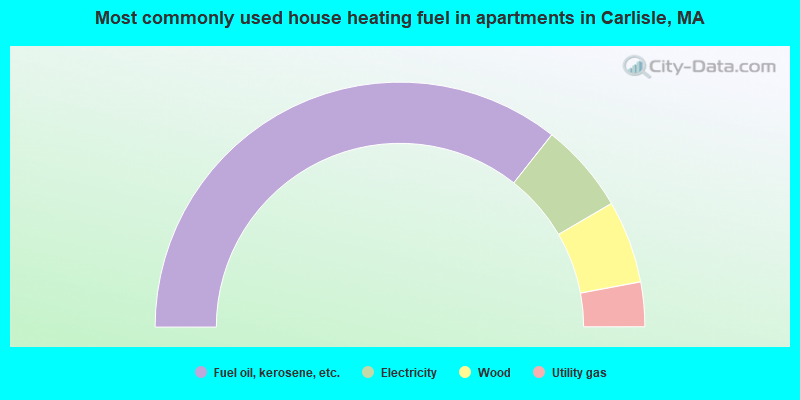
- 71.3%Fuel oil, kerosene, etc.
- 11.9%Electricity
- 10.9%Wood
- 5.9%Utility gas
Carlisle compared to Massachusetts state average:
- Median household income above state average.
- Median house value above state average.
- Unemployed percentage significantly below state average.
- Black race population percentage significantly below state average.
- Hispanic race population percentage significantly below state average.
- Median age above state average.
- Renting percentage significantly below state average.
- Length of stay since moving in significantly above state average.
- Number of rooms per house significantly below state average.
- House age significantly below state average.
- Number of college students below state average.
- Percentage of population with a bachelor's degree or higher significantly above state average.
Carlisle on our top lists:
- #60 on the list of "Top 100 best educated cities (highest percentage of bachelor degree holding residents)"
- #96 on the list of "Top 100 cities with highest median household income"
- #13 (01741) on the list of "Top 101 zip codes with the largest percentage of taxpayers using charity contributions deductions in 2012 (pop 1,000+)"
- #62 (01741) on the list of "Top 101 zip codes with the largest percentage of taxpayers reporting net capital gain/loss in 2012 (pop 1,000+)"
- #70 (01741) on the list of "Top 101 zip codes with the largest percentage of taxpayers reporting taxable interest in 2012 (pop 1,000+)"
- #4 on the list of "Top 101 counties with the most Orthodox adherents"
- #7 on the list of "Top 101 counties with the most Catholic adherents"
- #7 on the list of "Top 101 counties with the most Mainline Protestant congregations"
- #7 on the list of "Top 101 counties with the most Orthodox congregations"
- #8 on the list of "Top 101 counties with the lowest percentage of residents that keep firearms around their homes"

|
|
Total of 1210 patent applications in 2008-2024.