Birds, Illinois
Submit your own pictures of this village and show them to the world
- OSM Map
- General Map
- Google Map
- MSN Map

Population change since 2000: -3.9%
 |
| Males: 22 | |
| Females: 27 |
| Median resident age: | 37.2 years |
| Illinois median age: | 34.7 years |
Zip code: 62427
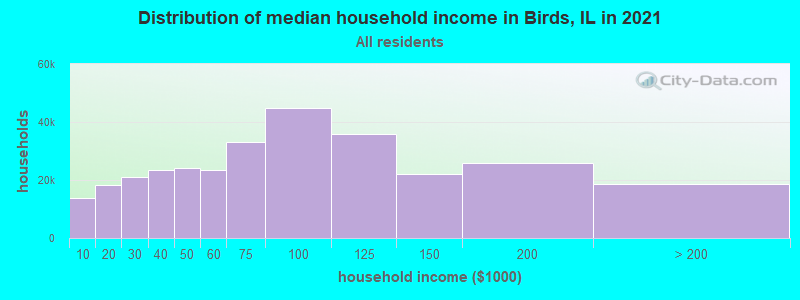
| Birds: | $42,137 |
| IL: | $76,708 |
Estimated per capita income in 2022: $16,454 (it was $9,216 in 2000)
Estimated median house or condo value in 2022: $60,383 (it was $27,500 in 2000)
| Birds: | $60,383 |
| IL: | $251,600 |


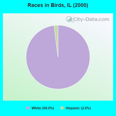
- 5098.0%White alone
- 12.0%Hispanic
 Recent articles from our blog. Our writers, many of them Ph.D. graduates or candidates, create easy-to-read articles on a wide variety of topics.


Latest news from Birds, IL collected exclusively by city-data.com from local newspapers, TV, and radio stations
Ancestries: Irish (11.8%), German (7.8%), Scotch-Irish (3.9%), United States (3.9%).
Current Local Time: CST time zone
Incorporated on 04/28/1896
Elevation: 435 feet
Land area: 0.22 square miles.
Population density: 226 people per square mile (very low).

| Birds village: | 0.9% ($250) |
| Illinois: | 1.8% ($2,285) |
Nearest city with pop. 50,000+: Terre Haute, IN  (46.3 miles , pop. 59,614).
Nearest city with pop. 200,000+: Indianapolis, IN (104.8 miles , pop. 781,870).
Nearest city with pop. 1,000,000+: Chicago, IL (207.8 miles , pop. 2,896,016).
Nearest cities:
), Latitude: 38.84 N, Longitude: 87.67 W
Area code: 618

| Here: | 5.3% |
| Illinois: | 4.2% |
Average climate in Birds, Illinois
Based on data reported by over 4,000 weather stations


Tornado activity:
Birds-area historical tornado activity is slightly below Illinois state average. It is 50% greater than the overall U.S. average.
On 1/7/1989, a category F4 (max. wind speeds 207-260 mph) tornado 19.7 miles away from the Birds village center injured 55 people and caused between $5,000,000 and $50,000,000 in damages.
On 6/2/1990, a category F4 tornado 23.6 miles away from the village center injured 2 people and caused between $50,000 and $500,000 in damages.
Earthquake activity:
Birds-area historical earthquake activity is significantly above Illinois state average. It is 176% greater than the overall U.S. average.On 4/18/2008 at 09:36:59, a magnitude 5.4 (5.1 MB, 4.8 MS, 5.4 MW, 5.2 MW, Class: Moderate, Intensity: VI - VII) earthquake occurred 29.1 miles away from the city center
On 4/18/2008 at 09:36:59, a magnitude 5.2 (5.2 MW, Depth: 8.9 mi) earthquake occurred 29.1 miles away from Birds center
On 6/10/1987 at 23:48:54, a magnitude 5.1 (4.9 MB, 4.4 MS, 4.6 MS, 5.1 LG) earthquake occurred 11.7 miles away from the city center
On 6/18/2002 at 17:37:15, a magnitude 5.0 (4.3 MB, 4.6 MW, 5.0 LG) earthquake occurred 59.1 miles away from Birds center
On 4/18/2008 at 15:14:16, a magnitude 4.8 (4.5 MB, 4.8 MW, 4.6 MW, Class: Light, Intensity: IV - V) earthquake occurred 26.7 miles away from Birds center
On 4/18/2008 at 15:14:17, a magnitude 4.7 (4.7 MW, Depth: 9.6 mi) earthquake occurred 28.3 miles away from the city center
Magnitude types: regional Lg-wave magnitude (LG), body-wave magnitude (MB), surface-wave magnitude (MS), moment magnitude (MW)
Natural disasters:
The number of natural disasters in Lawrence County (8) is smaller than the US average (15).Major Disasters (Presidential) Declared: 5
Emergencies Declared: 2
Causes of natural disasters: Floods: 5, Storms: 5, Hurricane: 1, Snow: 1, Tornado: 1, Wind: 1, Other: 1 (Note: some incidents may be assigned to more than one category).

Hospitals and medical centers near Birds:
- LAWRENCE COUNTY MEMORIAL HOSPITAL Critical Access Hospitals (about 8 miles away; LAWRENCEVILLE, IL)
- UNITED METHODIST VILLAGE, NORTH CAMPUS (Nursing Home, about 8 miles away; LAWRENCEVILLE, IL)
- UNITED METHODIST VILLAGE, THE (Nursing Home, about 9 miles away; LAWRENCEVILLE, IL)
- SOUTH HAVEN HOME (Hospital, about 13 miles away; ROBINSON, IL)
- COTILLION RIDGE NURSING CENTER (Nursing Home, about 13 miles away; ROBINSON, IL)
- CRAWFORD MEMORIAL HOSPITAL Critical Access Hospitals (about 13 miles away; ROBINSON, IL)
- CRAWFORD MEMORIAL HOSPITAL LTC (Nursing Home, about 13 miles away; ROBINSON, IL)
Colleges/universities with over 2000 students nearest to Birds:
- Vincennes University (about 13 miles; Vincennes, IN; Full-time enrollment: 9,876)
- Wabash Valley College (about 29 miles; Mount Carmel, IL; FT enrollment: 2,142)
- Indiana State University (about 46 miles; Terre Haute, IN; FT enrollment: 10,925)
- Rose-Hulman Institute of Technology (about 49 miles; Terre Haute, IN; FT enrollment: 2,123)
- Eastern Illinois University (about 53 miles; Charleston, IL; FT enrollment: 9,414)
- Lake Land College (about 57 miles; Mattoon, IL; FT enrollment: 7,499)
- University of Southern Indiana (about 61 miles; Evansville, IN; FT enrollment: 9,532)
Points of interest:
| This village: | 2.3 people |
| Illinois: | 2.6 people |
| This village: | 59.1% |
| Whole state: | 68.1% |
| This village: | 27.3% |
| Whole state: | 4.8% |
No gay or lesbian households reported
| This village: | 20.0% |
| Whole state: | 10.7% |
| This village: | 10.0% |
| Whole state: | 5.1% |
For population 15 years and over in Birds:
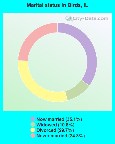
- Never married: 24.3%
- Now married: 35.1%
- Separated: 0.0%
- Widowed: 10.8%
- Divorced: 29.7%
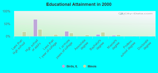
For population 25 years and over in Birds:
- High school or higher: 100.0%
- Bachelor's degree or higher: 12.0%
- Graduate or professional degree: 4.0%
- Mean travel time to work (commute): 21.6 minutes
| Here: | 5.6 |
| Illinois average: | 13.1 |
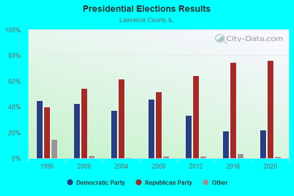
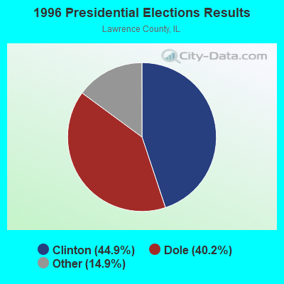
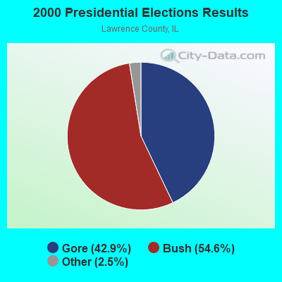
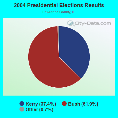
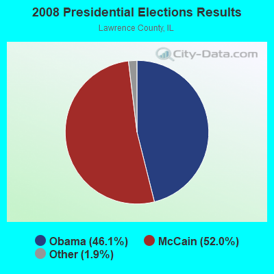
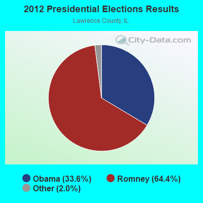
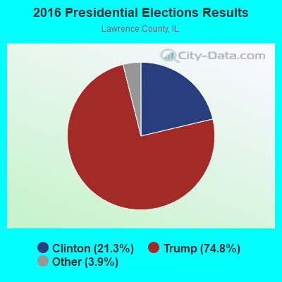
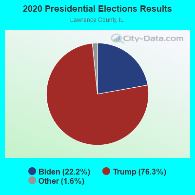
Graphs represent county-level data. Detailed 2008 Election Results
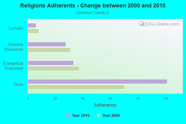
Religion statistics for Birds, IL (based on Lawrence County data)
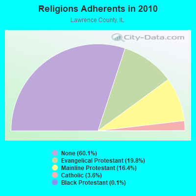
| Religion | Adherents | Congregations |
|---|---|---|
| Evangelical Protestant | 3,333 | 27 |
| Mainline Protestant | 2,756 | 23 |
| Catholic | 610 | 2 |
| Black Protestant | 19 | 1 |
| None | 10,115 | - |
Food Environment Statistics:
| Lawrence County: | 1.79 / 10,000 pop. |
| Illinois: | 2.24 / 10,000 pop. |
| Lawrence County: | 1.19 / 10,000 pop. |
| Illinois: | 0.75 / 10,000 pop. |
| This county: | 2.99 / 10,000 pop. |
| Illinois: | 2.61 / 10,000 pop. |
| Here: | 6.57 / 10,000 pop. |
| Illinois: | 6.86 / 10,000 pop. |
| This county: | 8.9% |
| Illinois: | 8.3% |
| Lawrence County: | 26.1% |
| Illinois: | 25.2% |
| Lawrence County: | 16.9% |
| State: | 14.5% |
| Local government employment and payroll (March 2007) | |||||
| Function | Full-time employees | Monthly full-time payroll | Average yearly full-time wage | Part-time employees | Monthly part-time payroll |
|---|---|---|---|---|---|
| Local Libraries | 0 | $0 | 0 | $0 | |
| Streets and Highways | 0 | $0 | 0 | $0 | |
| Fire - Other | 0 | $0 | 0 | $0 | |
| Firefighters | 0 | $0 | 0 | $0 | |
| Police - Other | 0 | $0 | 0 | $0 | |
| Judicial and Legal | 0 | $0 | 0 | $0 | |
| Other Government Administration | 0 | $0 | 8 | $181 | |
| Police Protection - Officers | 0 | $0 | 0 | $0 | |
| Financial Administration | 0 | $0 | 0 | $0 | |
| Water Supply | 0 | $0 | 0 | $0 | |
| Other and Unallocable | 0 | $0 | 0 | $0 | |
| Electric Power | 0 | $0 | 0 | $0 | |
| Parks and Recreation | 0 | $0 | 0 | $0 | |
| Sewerage | 0 | $0 | 0 | $0 | |
| Solid Waste Management | 0 | $0 | 0 | $0 | |
| Hospitals | 0 | $0 | 0 | $0 | |
| Health | 0 | $0 | 0 | $0 | |
| Welfare | 0 | $0 | 0 | $0 | |
| Totals for Government | 0 | $0 | 8 | $181 | |
Birds government finances - Expenditure in 2002 (per resident):
- Current Operations - Regular Highways: $8,000 ($163.27)
Central Staff Services: $7,000 ($142.86)
- Total Salaries and Wages: $2,000 ($40.82)
Birds government finances - Revenue in 2002 (per resident):
- Miscellaneous - Interest Earnings: $1,000 ($20.41)
- State Intergovernmental - General Support: $7,000 ($142.86)
Highways: $2,000 ($40.82)
- Tax - Property: $1,000 ($20.41)
Other: $1,000 ($20.41)
Birds government finances - Cash and Securities in 2002 (per resident):
- Other Funds - Cash and Deposits: $81,000 ($1653.06)
Strongest AM radio stations in Birds:
- WAKO (910 AM; 0 kW; LAWRENCEVILLE, IL; Owner: LAWRENCEVILLE BROADCASTING CO., INC.)
- WIBC (1070 AM; 50 kW; INDIANAPOLIS, IN; Owner: EMMIS RADIO LICENSE CORPORATION)
- WAOV (1450 AM; 1 kW; VINCENNES, IN; Owner: OLD NORTHWEST BROADCASTING, INC.)
- WHAS (840 AM; 50 kW; LOUISVILLE, KY; Owner: CLEAR CHANNEL BROADCASTING LICENSES, INC.)
- KXEN (1010 AM; 50 kW; FESTUS-ST. LOUIS, MO; Owner: BDJ RADIO ENTERPRISES, LLC)
- KMOX (1120 AM; 50 kW; ST. LOUIS, MO; Owner: INFINITY BROADCASTING OPERATIONS, INC.)
- WLW (700 AM; 50 kW; CINCINNATI, OH; Owner: JACOR BROADCASTING CORPORATION)
- WSM (650 AM; 50 kW; NASHVILLE, TN; Owner: GAYLORD ENTERTAINMENT COMPANY)
- WLS (890 AM; 50 kW; CHICAGO, IL; Owner: WLS, INC.)
- WSCR (670 AM; 50 kW; CHICAGO, IL; Owner: INFINITY BROADCASTING OPERATIONS, INC.)
- WPFR (1480 AM; 5 kW; TERRE HAUTE, IN)
- WGN (720 AM; 50 kW; CHICAGO, IL; Owner: WGN CONTINENTAL BROADCASTING CO.)
- WBBM (780 AM; 50 kW; CHICAGO, IL; Owner: INFINITY BROADCASTING OPERATIONS, INC.)
Strongest FM radio stations in Birds:
- WAKO-FM (103.1 FM; LAWRENCEVILLE, IL; Owner: LAWRENCEVILLE BROADCASTING CO., INC.)
- WTYE (101.7 FM; ROBINSON, IL; Owner: ANN BROADCASTING CORPORATION)
- WFML (96.7 FM; VINCENNES, IN; Owner: THE VINCENNES UNIVERSITY FOUNDATION, INC.)
- WVUB (91.1 FM; VINCENNES, IN; Owner: VINCENNES UNIVERSITY)
- WUZR (105.7 FM; BICKNELL, IN; Owner: OLD NORTHWEST BROADCASTING INC.)
- WZDM (92.1 FM; VINCENNES, IN; Owner: OLD NORTHWEST BROADCASTING INC.)
- WATI (89.9 FM; VINCENNES, IN; Owner: AMERICAN FAMILY ASSOCIATION)
- WQTY (93.3 FM; LINTON, IN; Owner: THE ORIGINAL COMPANY, INC.)
- WUSI (90.3 FM; OLNEY, IL; Owner: BOARD OF TRUSTEES OF S. ILL. UNIVER.)
- WWBL (106.5 FM; WASHINGTON, IN; Owner: OLD NORTHWEST BROADCASTING, INC.)
- WNDI-FM (95.3 FM; SULLIVAN, IN; Owner: J T M BROADCASTING CORPORATION)
- WBOW-FM (102.7 FM; TERRE HAUTE, IN; Owner: CROSSROADS INVESTMENTS, LLC)
- WBHW (88.7 FM; LOOGOOTEE, IN; Owner: MUSIC MINISTRIES, INC.)
- WAMW-FM (107.9 FM; WASHINGTON, IN; Owner: GREENE ELECTRONICS)
TV broadcast stations around Birds:
- WUSI-TV (Channel 16; OLNEY, IL; Owner: BD. OF TRUSTEES SOUTHERN ILLINOIS UNIVERSITY)
- WVUT (Channel 22; VINCENNES, IN; Owner: BOARD OF TRUSTEES FOR THE VINCENNES UNIV.)
- WTWO (Channel 2; TERRE HAUTE, IN; Owner: NEXSTAR BROADCASTING OF THE MIDWEST, INC.)
- WBAK-TV (Channel 38; TERRE HAUTE, IN; Owner: INDIANA BROADCASTING PARTNERS)
- WTHI-TV (Channel 10; TERRE HAUTE, IN; Owner: EMMIS TELEVISION LICENSE CORPORATION)
- W57AO (Channel 57; ROBINSON, IL; Owner: FULL GOS. BUS. MENS. FELLOW INTL.)
- National Bridge Inventory (NBI) Statistics
- 2Number of bridges
- 13ft / 3.9mTotal length
- $276,000Total costs
- 575Total average daily traffic
- 106Total average daily truck traffic
- 845Total future (year 2032) average daily traffic
FCC Registered Microwave Towers:
1- IL-BIRDS-SW-1, Cotton Lane And Pleasant Ridg Rd (Lat: 38.821750 Lon: -87.698194), Type: Ltower, Structure height: 54.9 m, Call Sign: WRUH843,
Assigned Frequencies: 11485.0 MHz, 11645.0 MHz, 11485.0 MHz, 19460.0 MHz, 11485.0 MHz, 11645.0 MHz, 11485.0 MHz, 19460.0 MHz, 11485.0 MHz, 11645.0 MHz... (+40 more), Grant Date: 08/29/2022, Expiration Date: 08/29/2032, Certifier: Jack Marsh, Registrant: Amg Technology Investment Group, LLC, 95 Parker Oaks Lane, Hudson Oaks, TX 76087, Phone: (855) 698-5465, Email:
Birds compared to Illinois state average:
- Median household income below state average.
- Median house value significantly below state average.
- Unemployed percentage significantly below state average.
- Black race population percentage significantly below state average.
- Hispanic race population percentage significantly below state average.
- Foreign-born population percentage significantly below state average.
- Renting percentage significantly below state average.
- Length of stay since moving in significantly above state average.
- Number of rooms per house significantly below state average.
- House age significantly below state average.
- Number of college students significantly below state average.
- Percentage of population with a bachelor's degree or higher below state average.