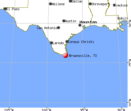
Brownsville, Texas
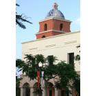
Brownsville: Brownsville Historic Museum
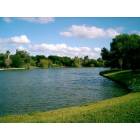
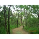
Brownsville: One of many resacas (ox-bow lakes) found in the city.
Brownsville: University of Texas At Brownsville
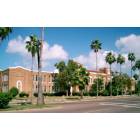
Brownsville: Original Brownsville High School
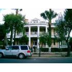
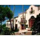
Brownsville: One of many historic homes restored in Downtown Brownsville.

Brownsville: green lizard on a mini palm tree leaf
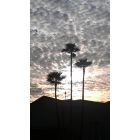
Brownsville: Sunrise in Brrownsville 01/12
Brownsville: World Birding Center

Brownsville: Sunrise in Brrownsville 01/12
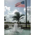
Brownsville: Flag in front of the Event Center
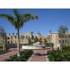
Brownsville: The new Student Union at the University of Texas at Brownsville.
- see
15
more - add
your
Submit your own pictures of this city and show them to the world
- OSM Map
- General Map
- Google Map
- MSN Map
Population change since 2000: +35.5%
| Males: 93,681 | |
| Females: 95,701 |
| Median resident age: | 28.6 years |
| Texas median age: | 35.6 years |
Zip codes: 78520, 78521, 78526, 78575, 78578.
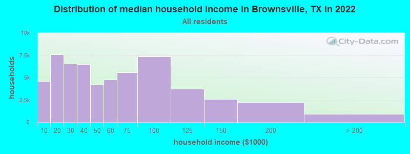
Brownsville Zip Code Map| Brownsville: | $46,912 |
| TX: | $72,284 |
Estimated per capita income in 2022: $18,068 (it was $9,762 in 2000)
Brownsville city income, earnings, and wages data
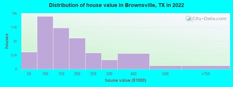
Estimated median house or condo value in 2022: $133,300 (it was $49,400 in 2000)
| Brownsville: | $133,300 |
| TX: | $275,400 |
Mean prices in 2022: all housing units: $164,881; detached houses: $164,202; townhouses or other attached units: $111,688; in 2-unit structures: $310,600; in 3-to-4-unit structures: $130,230; in 5-or-more-unit structures: $75,534; mobile homes: $45,764; occupied boats, rvs, vans, etc.: $33,515
Median gross rent in 2022: $892.
(18.7% for White Non-Hispanic residents, 22.0% for Black residents, 24.4% for Hispanic or Latino residents, 19.2% for American Indian residents, 9.3% for Native Hawaiian and other Pacific Islander residents, 27.4% for other race residents, 23.5% for two or more races residents)
Detailed information about poverty and poor residents in Brownsville, TX


Compare current foreclosures in Brownsville, TX:
| Photo | Address | Area | Beds / Baths | Price | Details |
|---|---|---|---|---|---|

|
#1
Toronja Ave
Brownsville, TX 78521
|
1,077 sq. feet
|
2 baths 3 beds |
show details | |

|
#2
Cuba St
Brownsville, TX 78526
|
1,554 sq. feet
|
2 baths 3 beds |
show details | |

|
#3
W Elizabeth St
Brownsville, TX 78520
|
3,759 sq. feet
|
4 baths 7 beds |
show details | |

|
#4
S Indiana Ave
Brownsville, TX 78521
|
1,758 sq. feet
|
1 baths 3 beds |
show details | |

|
#5
Illinois Ave N
Brownsville, TX 78521
|
1,856 sq. feet
|
1 baths 3 beds |
show details | |

|
#6
Boca Chica Blvd
Brownsville, TX 78520
|
1,718 sq. feet
|
1 baths 3 beds |
show details | |

|
#7
Laguna De Palmas Dr
Brownsville, TX 78526
|
1,051 sq. feet
|
1 baths 3 beds |
show details | |

|
#8
Kevin
Brownsville, TX 78521
|
1,140 sq. feet
|
2 baths 3 beds |
show details | |

|
#9
Gruta St
Brownsville, TX 78521
|
630 sq. feet
|
1 baths 3 beds |
show details | |

|
#10
Mesquite Wood Ct
Brownsville, TX 78526
|
3,128 sq. feet
|
2 baths 3 beds |
show details |
| Photo | Address | Area | Beds / Baths | Price | Details |
|---|---|---|---|---|---|

|
#11
Draper Dr
Brownsville, TX 78521
|
1,534 sq. feet
|
2 baths 4 beds |
show details | |

|
#12
Westminster Rd
Brownsville, TX 78521
|
2,852 sq. feet
|
3 baths 4 beds |
show details | |

|
#13
E 21st St
Brownsville, TX 78521
|
1,008 sq. feet
|
1 baths 3 beds |
show details | |

|
#14
Blanche St
Brownsville, TX 78521
|
1,763 sq. feet
|
2 baths 3 beds |
show details | |

|
#15
E 13th St
Brownsville, TX 78521
|
1,108 sq. feet
|
- baths 3 beds |
show details | |

|
#16
Fleet St
Brownsville, TX 78521
|
1,643 sq. feet
|
- baths 3 beds |
show details | |

|
#17
Resaca Vista Dr
Brownsville, TX 78526
|
1,462 sq. feet
|
- baths 3 beds |
show details | |

|
#18
Naples St
Brownsville, TX 78520
|
1,376 sq. feet
|
- baths 4 beds |
show details | |

|
#19
Lamplight
Brownsville, TX 78526
|
2,228 sq. feet
|
- baths 3 beds |
show details | |

|
#20
El Arco St
Brownsville, TX 78520
|
925 sq. feet
|
- baths - beds |
show details |
| Photo | Address | Area | Beds / Baths | Price | Details |
|---|---|---|---|---|---|

|
#21
Meadow Brooke Dr
Brownsville, TX 78526
|
- sq. feet
|
- baths - beds |
show details | |

|
#22
Mississippi River Blvd
Brownsville, TX 78520
|
660 sq. feet
|
- baths - beds |
show details | |

|
#23
Winterhaven Ln
Brownsville, TX 78526
|
- sq. feet
|
- baths - beds |
show details | |

|
#24
Windsor Pl
Brownsville, TX 78520
|
1,472 sq. feet
|
- baths - beds |
show details | |

|
#25
Pardo Ln
Brownsville, TX 78520
|
1,428 sq. feet
|
- baths - beds |
show details | |

|
#26
Achievement
Brownsville, TX 78526
|
1,246 sq. feet
|
- baths - beds |
show details | |

|
#27
Greenwood Dr
Brownsville, TX 78526
|
1,491 sq. feet
|
- baths - beds |
show details | |

|
#28
El Litro
Brownsville, TX 78520
|
1,226 sq. feet
|
- baths - beds |
show details | |

|
#29
Saint James Dr
Brownsville, TX 78521
|
- sq. feet
|
- baths - beds |
show details | |

|
#30
Jennifer Ave
Brownsville, TX 78521
|
- sq. feet
|
- baths - beds |
show details |
| Photo | Address | Area | Beds / Baths | Price | Details |
|---|---|---|---|---|---|

|
#31
Tradition Cir
Brownsville, TX 78526
|
1,218 sq. feet
|
- baths - beds |
show details | |

|
#32
Deer Trl
Brownsville, TX 78521
|
- sq. feet
|
- baths - beds |
show details | |

|
#33
Magali Cir
Brownsville, TX 78521
|
- sq. feet
|
- baths - beds |
show details | |

|
#34
Autumn Sage Dr
Brownsville, TX 78526
|
1,005 sq. feet
|
- baths - beds |
show details | |

|
#35
Ivy Ln
Brownsville, TX 78521
|
1,419 sq. feet
|
- baths - beds |
show details | |

|
#36
Carlos Ave
Brownsville, TX 78526
|
1,194 sq. feet
|
- baths - beds |
show details | |

|
#37
Calgary Ct
Brownsville, TX 78526
|
- sq. feet
|
- baths - beds |
show details | |

|
#38
El Arbol
Brownsville, TX 78520
|
968 sq. feet
|
- baths - beds |
show details | |

|
#39
El Valle Dr
Brownsville, TX 78521
|
1,091 sq. feet
|
- baths - beds |
show details | |

|
#40
Ebony Ave
Brownsville, TX 78520
|
2,020 sq. feet
|
- baths - beds |
show details |
| Photo | Address | Area | Beds / Baths | Price | Details |
|---|---|---|---|---|---|

|
#41
Ramada Dr
Brownsville, TX 78521
|
768 sq. feet
|
- baths - beds |
show details | |

|
#42
Highland Pine St
Brownsville, TX 78526
|
1,983 sq. feet
|
- baths - beds |
show details | |

|
#43
Calle Buenos Aires
Brownsville, TX 78526
|
1,146 sq. feet
|
- baths - beds |
show details | |

|
#44
Padre Island Hwy
Brownsville, TX 78521
|
- sq. feet
|
- baths - beds |
show details | |

|
#45
Palacio Real Dr
Brownsville, TX 78521
|
- sq. feet
|
- baths - beds |
show details | |

|
#46
Winnipeg Ave
Brownsville, TX 78526
|
- sq. feet
|
- baths - beds |
show details | |

|
#47
Dahlia Cir
Brownsville, TX 78520
|
1,453 sq. feet
|
- baths - beds |
show details | |

|
#48
Woodlands Ave
Brownsville, TX 78526
|
- sq. feet
|
- baths - beds |
show details | |

|
#49
Janet Ln
Brownsville, TX 78526
|
1,503 sq. feet
|
- baths - beds |
show details | |

|
Check over 1 million property listings on Foreclosure.com!
|
browse all offers | |||


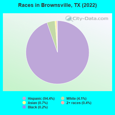
- 177,95894.4%Hispanic
- 7,7164.1%White alone
- 1,4070.7%Asian alone
- 7490.4%Two or more races
- 4160.2%Black alone
- 1440.08%Other race alone
- 880.05%American Indian alone
- 230.01%Native Hawaiian and Other
Pacific Islander alone
Races in Brownsville detailed stats: ancestries, foreign born residents, place of birth
According to our research of Texas and other state lists, there were 334 registered sex offenders living in Brownsville, Texas as of April 27, 2024.
The ratio of all residents to sex offenders in Brownsville is 550 to 1.
The ratio of registered sex offenders to all residents in this city is lower than the state average.
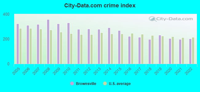
The City-Data.com crime index weighs serious crimes and violent crimes more heavily. Higher means more crime, U.S. average is 246.1. It adjusts for the number of visitors and daily workers commuting into cities.
- means the value is smaller than the state average.- means the value is about the same as the state average.
- means the value is bigger than the state average.
- means the value is much bigger than the state average.
Crime rate in Brownsville detailed stats: murders, rapes, robberies, assaults, burglaries, thefts, arson
Full-time law enforcement employees in 2021, including police officers: 301 (226 officers - 199 male; 27 female).
| Officers per 1,000 residents here: | 1.23 |
| Texas average: | 2.07 |
 Recent articles from our blog. Our writers, many of them Ph.D. graduates or candidates, create easy-to-read articles on a wide variety of topics.

 | Typical utility, water and sewer monthly bill in Brownsville Texas (1 reply) |
| Why is it that Houston seems to have more of an "energetic vibe" than Dallas? (607 replies) |
| Non-Hispanic in Brownsville/McAllen? (18 replies) |
| Brownsville, TX what's it like (30 replies) |
| Who is Really Moving to Texas? (64 replies) |
| How is brownsville in 2019, good,bad, blooming? (33 replies) |
Latest news from Brownsville, TX collected exclusively by city-data.com from local newspapers, TV, and radio stations
Ancestries: American (1.6%).
Current Local Time: CST time zone
Land area: 80.4 square miles.
Population density: 2,356 people per square mile (low).
52,911 residents are foreign born (26.4% Latin America).
| This city: | 28.1% |
| Texas: | 17.1% |
Median real estate property taxes paid for housing units with mortgages in 2022: $2,794 (1.8%)
Median real estate property taxes paid for housing units with no mortgage in 2022: $1,836 (1.7%)
Nearest city with pop. 200,000+: Corpus Christi, TX  (125.5 miles , pop. 277,454).
Nearest city with pop. 1,000,000+: San Antonio, TX (251.6 miles , pop. 1,144,646).
Nearest cities:
), ), ), ), ), ), ), )Latitude: 25.93 N, Longitude: 97.48 W
Daytime population change due to commuting: +312 (+0.2%)
Workers who live and work in this city: 53,883 (71.3%)
Area code: 956
Property values in Brownsville, TX
Brownsville, Texas accommodation & food services, waste management - Economy and Business Data
Single-family new house construction building permits:
- 2022: 817 buildings, average cost: $235,200
- 2021: 883 buildings, average cost: $103,500
- 2020: 772 buildings, average cost: $103,800
- 2019: 679 buildings, average cost: $102,800
- 2018: 665 buildings, average cost: $101,500
- 2017: 575 buildings, average cost: $112,100
- 2016: 568 buildings, average cost: $148,100
- 2015: 519 buildings, average cost: $98,900
- 2014: 549 buildings, average cost: $113,300
- 2013: 545 buildings, average cost: $98,300
- 2012: 570 buildings, average cost: $97,900
- 2011: 611 buildings, average cost: $95,800
- 2010: 578 buildings, average cost: $97,500
- 2009: 480 buildings, average cost: $102,500
- 2008: 464 buildings, average cost: $102,100
- 2007: 861 buildings, average cost: $97,100
- 2006: 1316 buildings, average cost: $83,100
- 2005: 1428 buildings, average cost: $88,700
- 2004: 1468 buildings, average cost: $82,200
- 2003: 1649 buildings, average cost: $80,800
- 2002: 1723 buildings, average cost: $75,300
- 2001: 1425 buildings, average cost: $72,000
- 2000: 1549 buildings, average cost: $66,500
- 1999: 835 buildings, average cost: $74,100
- 1998: 846 buildings, average cost: $75,100
- 1997: 654 buildings, average cost: $63,700
| Here: | 5.0% |
| Texas: | 3.5% |
Population change in the 1990s: +23,880 (+20.6%).
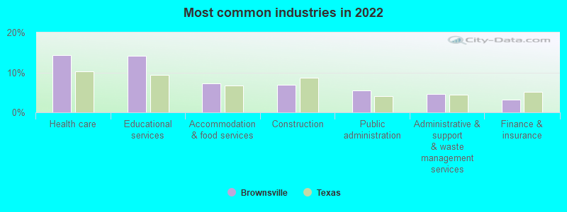
- Health care (14.4%)
- Educational services (14.2%)
- Accommodation & food services (7.3%)
- Construction (6.9%)
- Public administration (5.5%)
- Administrative & support & waste management services (4.7%)
- Finance & insurance (3.2%)
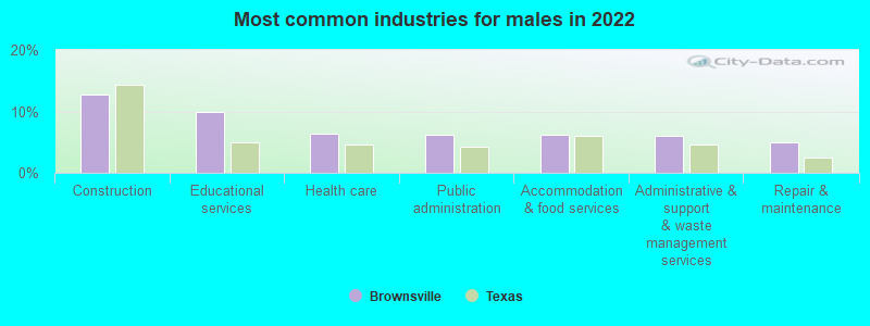
- Construction (12.8%)
- Educational services (10.0%)
- Health care (6.4%)
- Public administration (6.2%)
- Accommodation & food services (6.2%)
- Administrative & support & waste management services (5.9%)
- Repair & maintenance (5.0%)
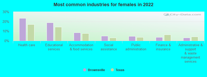
- Health care (23.3%)
- Educational services (19.0%)
- Accommodation & food services (8.6%)
- Social assistance (5.0%)
- Public administration (4.8%)
- Finance & insurance (3.7%)
- Administrative & support & waste management services (3.2%)
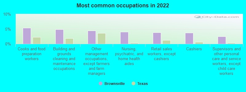
- Cooks and food preparation workers (5.4%)
- Building and grounds cleaning and maintenance occupations (4.8%)
- Other management occupations, except farmers and farm managers (4.4%)
- Nursing, psychiatric, and home health aides (4.0%)
- Retail sales workers, except cashiers (3.9%)
- Cashiers (3.7%)
- Supervisors and other personal care and service workers, except child care workers (2.5%)
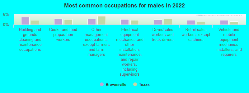
- Building and grounds cleaning and maintenance occupations (5.8%)
- Cooks and food preparation workers (4.5%)
- Other management occupations, except farmers and farm managers (4.4%)
- Electrical equipment mechanics and other installation, maintenance, and repair workers, including supervisors (4.2%)
- Driver/sales workers and truck drivers (3.8%)
- Retail sales workers, except cashiers (3.4%)
- Vehicle and mobile equipment mechanics, installers, and repairers (3.4%)

- Nursing, psychiatric, and home health aides (7.8%)
- Cooks and food preparation workers (6.3%)
- Cashiers (5.6%)
- Supervisors and other personal care and service workers, except child care workers (4.9%)
- Secretaries and administrative assistants (4.9%)
- Other management occupations, except farmers and farm managers (4.4%)
- Retail sales workers, except cashiers (4.3%)
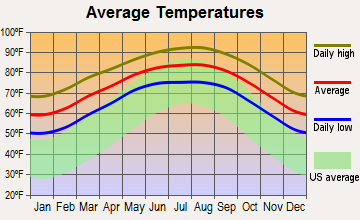
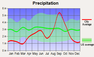
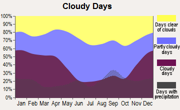
Average climate in Brownsville, Texas
Based on data reported by over 4,000 weather stations
|
|

(lower is better)
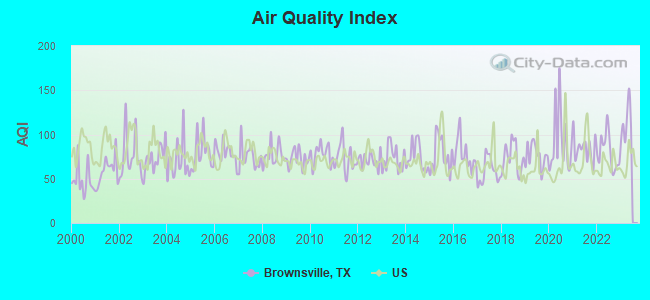
Air Quality Index (AQI) level in 2022 was 80.1. This is about average.
| City: | 80.1 |
| U.S.: | 72.6 |
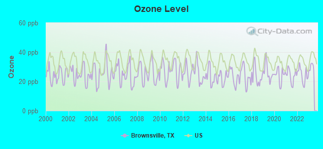
Ozone [ppb] level in 2022 was 24.4. This is better than average. Closest monitor was 2.7 miles away from the city center.
| City: | 24.4 |
| U.S.: | 33.3 |
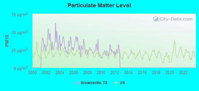
Particulate Matter (PM10) [µg/m3] level in 2012 was 23.1. This is worse than average. Closest monitor was 1.4 miles away from the city center.
| City: | 23.1 |
| U.S.: | 19.2 |
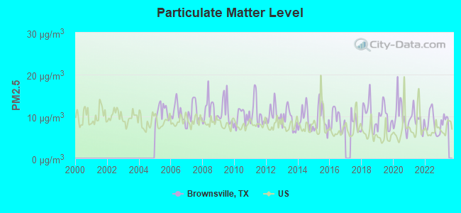
Particulate Matter (PM2.5) [µg/m3] level in 2022 was 8.14. This is about average. Closest monitor was 2.5 miles away from the city center.
| City: | 8.14 |
| U.S.: | 8.11 |
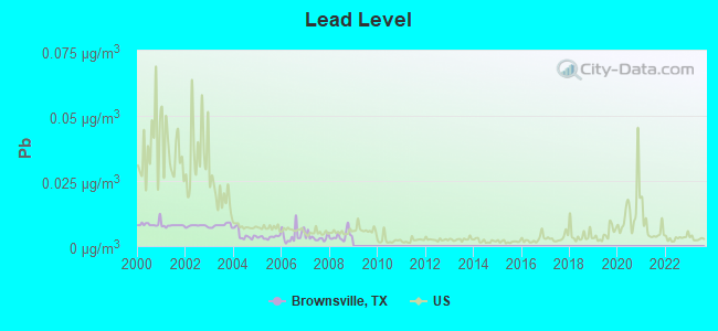
Lead (Pb) [µg/m3] level in 2008 was 0.00388. This is significantly better than average. Closest monitor was 1.4 miles away from the city center.
| City: | 0.00388 |
| U.S.: | 0.00931 |
Earthquake activity:
Brownsville-area historical earthquake activity is below Texas state average. It is 83% smaller than the overall U.S. average.On 10/20/2011 at 12:24:41, a magnitude 4.8 (4.8 MW, Depth: 3.1 mi, Class: Light, Intensity: IV - V) earthquake occurred 206.2 miles away from Brownsville center
On 11/13/2017 at 11:23:01, a magnitude 3.9 (3.9 MD, Depth: 3.1 mi, Class: Light, Intensity: II - III) earthquake occurred 61.5 miles away from Brownsville center
On 4/25/2010 at 02:10:42, a magnitude 3.9 (3.9 MB, Depth: 3.1 mi) earthquake occurred 125.0 miles away from Brownsville center
On 4/9/1993 at 12:29:19, a magnitude 4.3 (4.1 MB, 4.3 LG, Depth: 3.1 mi) earthquake occurred 203.1 miles away from Brownsville center
On 3/24/1997 at 22:31:34, a magnitude 3.8 (3.8 LG, Depth: 3.1 mi) earthquake occurred 128.5 miles away from Brownsville center
On 4/14/1995 at 00:32:56, a magnitude 5.7 (5.6 MB, 5.7 MS, 5.7 MW, Depth: 11.1 mi, Class: Moderate, Intensity: VI - VII) earthquake occurred 468.1 miles away from the city center
Magnitude types: regional Lg-wave magnitude (LG), body-wave magnitude (MB), duration magnitude (MD), surface-wave magnitude (MS), moment magnitude (MW)
Natural disasters:
The number of natural disasters in Cameron County (23) is greater than the US average (15).Major Disasters (Presidential) Declared: 12
Emergencies Declared: 8
Causes of natural disasters: Hurricanes: 12, Floods: 7, Storms: 6, Tornadoes: 3, Winds: 2, Fire: 1, Heavy Rain: 1, Tropical Storm: 1, Other: 2 (Note: some incidents may be assigned to more than one category).

Hospitals in Brownsville:
- BROWNSVILLE SURGICAL HOSPITAL (Proprietary, provides emergency services, 4750 NORTH EXPRESSWAY)
- CASA LINDA GROUP HOME (8 CASA LINDA)
- ODYSSEY HEALTHCARE OF SOUTH TEXAS (2501 PAREDES LINE ROAD SUITE B9)
- SOUTH TEXAS REHABILTATION HOSPITAL (425 EAST ALTON GLOOR BLVD)
- VALLEY REGIONAL MEDICAL CENTER (Proprietary, 100 A ALTON GLOOR)
- VHS BROWNSVILLE HOSPITAL COMPANY, LLC (Proprietary, provides emergency services, 1040 W JEFFERSON ST)
- WHISPERING PALMS (1415 W WASHINGTON)
Nursing Homes in Brownsville:
- ALTA VISTA REHABILITATION AND HEALTHCARE (510 PAREDES LINE RD)
- BROWNSVILLE GOOD SAMARITAN CTR (510 PAREDES LINE RD)
- BROWNSVILLE MEDICAL CENTER (1040 WEST JEFFERSON)
- BROWNSVILLE NURSING AND REHABILITATION CENTER (320 LORENALY DR)
- EBONY LAKE NURSING AND REHABILITATION CENTER (1001 CENTRAL BLVD)
- MOTHER OF PERPETUAL HELP NURSING HOME INC (519 E MADISON ST)
- SPANISH MEADOWS (440 E RUBEN TORRES BLVD)
- VALLEY BAPTIST MEDICAL CENTER BROWNSVILLE (1040 W JEFFERSON ST)
- VALLEY GRANDE MANOR (901 WILDROSE LN)
- VALLEY REGIONAL MEDICAL CENTER (1 TED HUNT BOULEVARD)
Dialysis Facilities in Brownsville:
- FMC DIALYSIS SERVICES OF NORTH BROWNSVILLE (1900 N. EXPRESSWAY, SUITE E)
- NRI BROWNSVILLE (2945 CENTRAL BLVD)
- VALLEY HEMODIALYSIS CENTER (2600 N CORIA)
Home Health Centers in Brownsville:
- ABUNDANT LIFE HOME HEALTH INC (1900 PECAN STREET)
- BORDER HOME HEALTH INC (1725 BOCA CHICA BLVD)
- CIMA HEALTH LATINO (954 PRICE RD)
- DOCTORS CHOICE HOME HEALTH (275 JOSE MARTI BLVD SUITE B & C)
- INTERIM HEALTHCARE HOSPICE (950 E ALTON GLOOR BOULEVARD)
- MED TEAM INC (135 UPTOWN AVE)
- MERCY HOME HEALTH (2100 FM 802 SUITE 2020)
- RIO MED 21 (301 LORENALY DRIVE SUITE E)
- TCM HEALTH CARE INC (100 PLAZA SANTA ROSA STE A)
- VALLEY ANGELS HOME HEALTH LLC (26 S CORIA ST SUITE D)
- VALLEYWIDE HOME CARE (805 WEST PRICE ROAD STE B4)
Airports and heliports located in Brownsville:
- Brownsville/South Padre Island International Airport (BRO) (Runways: 2, Commercial Ops: 1,804, Air Taxi Ops: 6,184, Itinerant Ops: 9,946, Local Ops: 2,204, Military Ops: 7,016)
- Resaca Airstrip Airport (80TX) (Runways: 1)
- Columbia Valley Regional Heliport (2XS0)
Colleges/Universities in Brownsville:
- The University of Texas at Brownsville (Full-time enrollment: 9,165; Location: One West University Boulevard; Public; Website: WWW.UTB.EDU; Offers Doctor's degree)
- Kaplan College-Brownsville (Full-time enrollment: 804; Location: 1900 North Expressway, Suite O; Private, for-profit; Website: www.kaplancollege.com/brownsville-tx/)
- Southern Careers Institute-Brownsville (Full-time enrollment: 634; Location: 1424 W Price Rd Ste K; Private, for-profit; Website: www.scitexas.edu)
- South Texas Vocational Technical Institute-Brownsville (Full-time enrollment: 524; Location: 2144 Central Blvd; Private, for-profit; Website: www.stvt.edu)
- Salon & Spa Institute (Full-time enrollment: 143; Location: 2695 North Coria Street; Private, for-profit; Website: www.salonspainstitute.com/)
Other colleges/universities with over 2000 students near Brownsville:
- Texas State Technical College-Harlingen (about 23 miles; Harlingen, TX; Full-time enrollment: 3,700)
- The University of Texas-Pan American (about 51 miles; Edinburg, TX; FT enrollment: 16,766)
- South Texas College (about 52 miles; McAllen, TX; FT enrollment: 19,701)
- Texas A & M University-Kingsville (about 113 miles; Kingsville, TX; FT enrollment: 9,295)
- Texas A & M University-Corpus Christi (about 125 miles; Corpus Christi, TX; FT enrollment: 9,092)
- Del Mar College (about 127 miles; Corpus Christi, TX; FT enrollment: 5,213)
- Texas A & M International University (about 166 miles; Laredo, TX; FT enrollment: 5,203)
Biggest public high schools in Brownsville:
- HANNA H S (Students: 3,184, Location: 2615 PRICE RD, Grades: 9-12)
- PORTER H S (Students: 2,447, Location: 3500 INTERNATIONAL BLVD, Grades: 9-12)
- RIVERA H S (Students: 2,257, Location: 6955 FM 802, Grades: 9-12)
- LOPEZ H S (Students: 2,239, Location: 3205 S DAKOTA AVE, Grades: 9-12)
- IDEA FRONTIER COLLEGE PREPARATORY (Students: 537, Location: 2800 S DAKOTA AVE, Grades: 6-12, Charter school)
- HARMONY SCIENCE ACADEMY - BROWNSVILLE (Students: 381, Location: 1124 CENTRAL BLVD, Grades: KG-12, Charter school)
- BROWNSVILLE EARLY COLLEGE H S (Students: 185, Location: 733 PALM BLVD, Grades: 9-12)
- PREMIER H S OF BROWNSVILLE (Location: 955 PAREDES LINE RD, Grades: 9-12, Charter school)
- PACE H S (Location: 314 W LOS EBANOS BLVD, Grades: 9-12)
- LINCOLN PARK SCH (Location: 7 ORANGE ST, Grades: PK-12)
Private high schools in Brownsville:
Biggest public elementary/middle schools in Brownsville:
- STILLMAN MIDDLE (Students: 1,354, Location: 2977 W TANDY RD, Grades: 6-8)
- HUDSON EL (Students: 1,251, Location: 2980 FM 802, Grades: PK-5)
- BURNS EL (Students: 1,146, Location: 1974 ALTON GLOOR BLVD, Grades: PK-5)
- OLIVEIRA MIDDLE (Students: 1,144, Location: 444 LAND O LAKES, Grades: 6-8)
- VELA MIDDLE (Students: 1,135, Location: 4905 PAREDES LINE RD, Grades: 6-8)
- EGLY EL (Students: 1,132, Location: 445 LAND O LAKES, Grades: PK-5)
- PAREDES EL (Students: 1,108, Location: 3700 HERITAGE TRL, Grades: PK-5)
- STELL MIDDLE (Students: 1,068, Location: 1105 LOS EBANOS BLVD, Grades: 6-8)
- LUCIO MIDDLE (Students: 1,064, Location: 300 N VERMILLION RD, Grades: 6-8)
- RUSSELL EL (Students: 950, Location: 800 LAKESIDE BLVD, Grades: PK-5)
Private elementary/middle schools in Brownsville:
- KENMONT MONTESSORI SCHOOL (Students: 484, Location: 2734 N CORIA ST, Grades: PK-8)
- ST MARY'S CATHOLIC SCHOOL (Students: 452, Location: 1300 E LOS EBANOS BLVD, Grades: PK-6)
- INCARNATE WORD ACADEMY (Students: 309, Location: 244 RESACA BLVD, Grades: UG-8)
- ST LUKE CATHOLIC SCHOOL (Students: 295, Location: 2850 E PRICE RD, Grades: KG-8)
- EPISCOPAL DAY SCHOOL (Students: 277, Location: 34 N CORIA ST, Grades: PK-6)
- FAITH CHRISTIAN ACADEMY (Students: 213, Location: 1944 E ALTON GLOOR BLVD, Grades: PK-8)
- GUADALUPE REGIONAL MIDDLE SCHOOL (Students: 84, Location: 1214 LINCOLN ST, Grades: 6-8)
- BROWNSVILLE MONTESSORI ACADEMY (Students: 53, Location: 36 S CORIA ST, Grades: PK-6)
- MONTESSORI SCHOOL (Students: 16, Location: 204 BOCA CHICA BLVD, Grades: PK-1)
Library in Brownsville:
User-submitted facts and corrections:
- SUNNYSIDE DAY SCHOOL no longer exists
- Private high school : St. Joseph Academy
Points of interest:
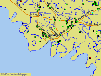
Notable locations in Brownsville: Palo Alto Battlefield (A), Resaca de la Palma Battlefield (B), Brownsville Country Club (C), Southern Pacific Railroad Passenger Depot (D), Palo Alto Battlefield (E), Miguel Fernandez Hide Yard (F), Fort Brown (G), Brownsville Fire Department Central Station (H), Brownsville Fire Department Station 3 (I), Brownsville Fire Department Station 2 (J), Brownsville Fire Department Station 4 (K), Brownsville Fire Department Station 5 (L), Brownsville Fire Department Station 6 (M), Brownsville Fire Department Station 7 (N), Brownsville Fire Department Station 9 (O), Brownsville Police Department (P), La Nueva Libertad (Q), La Madrilena (R), Cameron County Sheriff's Office (S), Manautou House (T). Display/hide their locations on the map
Shopping Center: Strawberry Square Shopping Center (1). Display/hide its location on the map
Churches in Brownsville include: First Presbyterian Church (A), La Iglesia del Pueblo Pentecostal Church (B), Iglesia de Dios Pentecostal Church (C), The Church of Jesus Christ of Latter Day Saints (D), Shepherd of the Valley Lutheran Church (E), El Calvario Lutheran Church (F), First Church of the Nazarene (G), Church of Christ (H), Trinity Baptist Church (I). Display/hide their locations on the map
Cemeteries: Santa Rosalia Cemetery (1), Buena Vista Cemetery (2), Old City Cemetery (3). Display/hide their locations on the map
Lakes and reservoirs: Resaca de la Palma (A), Town Resaca (B), Salt Pond (C), Fort Brown Resaca (D), Dana-Tule Reservoir 1 (E), Dana-Tule Reservoir 2 (F), Main Reservoir (G), Resaca de La Palma Reservoir (H). Display/hide their locations on the map
Parks in Brownsville include: Las Palomas Wildlife Management Area - Voshell Unit (1), Las Palomas Wildlife Management Area - Resaca de las Palomas (2), Las Palomas Wildlife Management Area - Brasil Unit (3), Portway Acres Park (4), Morningside Park (5), Washington Park (6), Tony Gonzales Park (7), Palo Alto Battlefield National Historic Site (8), Historical Monument (9). Display/hide their locations on the map
Tourist attractions: Brownsville City - Brownsville South Padre Island International Airpor- CAF Mu (Museums; 1001 East Elizabeth Street) (1), Brownsville Public Safety Museum (600 East Jackson Street) (2), Brownsville Historical Museum (641 East Madison Street) (3), Brownsville Heritage Resource Center (Museums; 1335 East Washington Street) (4), Brownsville Museum of Fine Art (230 Neale Drive) (5), Petrina Carlotta Museum (Art Museums; 1452 E Madison St) (6), Confederate Air Force-Rgv Wing (Cultural Attractions- Events- & Facilities; 955 South Minnesota Avenue) (7), Gladys Porter Zoo - Admission Information (Recreation Areas; 500 Ringgold Street) (8), Gladys Porter Zoo - Education Department (Recreation Areas; 500 Ringgold Street) (9). Display/hide their approximate locations on the map
Hotels: Best Western Rose Garden Inn (845 North Expressway 77/83) (1), Comfort Inn (825 North Expwy 83) (2), Best Value Colonial Hotel (1147 East Levee Street) (3), Action Restaurant Equipment (1509 East Madison Street) (4), Cameron Motor Hotel (912 East Washington Street) (5), Catzz Nightclub (3777 North Expressway) (6), Brownsville Super 8 Motel (55 Sam Perl Blvd) (7), Comfort Inn Brownsville (825 North Expressway 83) (8). Display/hide their approximate locations on the map
Court: United States Government - Federal Bureau Of Investigation- Brownsville Resident Ag (1700 Paredes Line Road) (1). Display/hide its approximate location on the map
Birthplace of: Kris Kristofferson - (born 1936), singer-songwriter, Eddie Lucio, Jr. - Texas politician, Grace Napolitano - Politician, Kristian Menchaca - Recipient of the Purple Heart medal, Tony Garza - Diplomat, Juan Arambula - Politician, Bernard L. Kowalski - Film director, Claire Raphael Reis - Music educator, Dorothy Vest - Tennis player, Eddie Lucio III - Politician.
Drinking water stations with addresses in Brownsville and their reported violations in the past:
BROWNSVILLE PUBLIC UTILITIES BOARD (Population served: 178,430, Surface water):Past monitoring violations:BROWNSVILLE NAVIGATION DISTRICT (Population served: 2,941, Purch surface water):
- Single Turbidity Exceed (Enhanced SWTR) - In DEC-2008, Contaminant: IESWTR. Follow-up actions: St Public Notif requested (APR-09-2008), St Violation/Reminder Notice (APR-09-2008), St Compliance achieved (AUG-09-2010)
- Monitoring, Turbidity (Enhanced SWTR) - In JAN-2005, Contaminant: IESWTR. Follow-up actions: St Compliance achieved (AUG-09-2010)
Past monitoring violations:
- Monitoring and Reporting (DBP) - Between OCT-2008 and DEC-2008, Contaminant: Chlorine. Follow-up actions: St Violation/Reminder Notice (MAR-27-2009), St Public Notif requested (MAR-27-2009), St Public Notif received (APR-13-2009), St Compliance achieved (AUG-04-2009)
Drinking water stations with addresses in Brownsville that have no violations reported:
- VENTANA CREEK (Population served: 90, Primary Water Source Type: Groundwater)
| This city: | 3.5 people |
| Texas: | 2.8 people |
| This city: | 82.3% |
| Whole state: | 69.9% |
| This city: | 4.6% |
| Whole state: | 6.0% |
Likely homosexual households (counted as self-reported same-sex unmarried-partner households)
- Lesbian couples: 0.4% of all households
- Gay men: 0.2% of all households
People in group quarters in Brownsville in 2010:
- 671 people in nursing facilities/skilled-nursing facilities
- 310 people in college/university student housing
- 186 people in local jails and other municipal confinement facilities
- 175 people in other noninstitutional facilities
- 136 people in group homes intended for adults
- 87 people in group homes for juveniles (non-correctional)
- 53 people in emergency and transitional shelters (with sleeping facilities) for people experiencing homelessness
- 19 people in mental (psychiatric) hospitals and psychiatric units in other hospitals
People in group quarters in Brownsville in 2000:
- 710 people in local jails and other confinement facilities (including police lockups)
- 688 people in nursing homes
- 137 people in other noninstitutional group quarters
- 73 people in other nonhousehold living situations
- 53 people in residential treatment centers for emotionally disturbed children
- 21 people in religious group quarters
- 6 people in homes for the mentally retarded
- 3 people in mental (psychiatric) hospitals or wards
Banks with most branches in Brownsville (2011 data):
- International Bank of Commerce: 9 branches. Info updated 2006/11/03: Bank assets: $952.8 mil, Deposits: $601.8 mil, local headquarters, positive income, Commercial Lending Specialization, 14 total offices, Holding Company: International Bancshares Corporation
- Wells Fargo Bank, National Association: Brownsville Downtown Branch, Sunrise Branch, Boca Chica Branch, Southmost Branch, Brownsville Downtown Mb Branch, Financial Center Branch. Info updated 2011/04/05: Bank assets: $1,161,490.0 mil, Deposits: $905,653.0 mil, headquarters in Sioux Falls, SD, positive income, 6395 total offices, Holding Company: Wells Fargo & Company
- Compass Bank: Brownsville Sunrise Mall Branch, Brownsville Fm802 Branch, Brownsville Boca Chica Branch, Brownsville Main Branch, Brownsville Central Branch. Info updated 2011/02/24: Bank assets: $63,107.0 mil, Deposits: $46,232.4 mil, headquarters in Birmingham, AL, negative income in the last year, Commercial Lending Specialization, 720 total offices, Holding Company: Banco Bilbao Vizcaya Argentaria, S.A.
- Capital One, National Association: Paredes Line Road Branch, Morrison Road Branch, Boca Chica Branch. Info updated 2011/07/01: Bank assets: $133,477.8 mil, Deposits: $97,063.7 mil, headquarters in Mclean, VA, positive income, 984 total offices, Holding Company: Capital One Financial Corporation
- JPMorgan Chase Bank, National Association: San Marcelo Branch, Boca Chica Branch, North Brownsville Branch. Info updated 2011/11/10: Bank assets: $1,811,678.0 mil, Deposits: $1,190,738.0 mil, headquarters in Columbus, OH, positive income, International Specialization, 5577 total offices, Holding Company: Jpmorgan Chase & Co.
- First National Bank: Morrison, Brownsville Levee Branch, Brownsville Branch. Info updated 2007/09/20: Bank assets: $3,517.0 mil, Deposits: $2,598.8 mil, headquarters in Edinburg, TX, negative income in the last year, Commercial Lending Specialization, 58 total offices, Holding Company: First National Bank Group, Inc.
- Lone Star National Bank: Boca Chica Branch at 1200 Boca Chica Blvd, branch established on 2005/06/01; Brownsville Branch at 3300 North Expressway 83, branch established on 2001/05/29. Info updated 2010/05/05: Bank assets: $2,174.7 mil, Deposits: $1,815.0 mil, headquarters in Pharr, TX, positive income, Commercial Lending Specialization, 27 total offices, Holding Company: Lone Star National Bancshares--texas, Inc.
- Bank of America, National Association: Boca Chica Banking Branch at 2635 Boca Chica Boulevard, branch established on 2004/10/20; Paseo De La Resaca Banking Branch at 101 America Drive, branch established on 2004/09/29. Info updated 2009/11/18: Bank assets: $1,451,969.3 mil, Deposits: $1,077,176.8 mil, headquarters in Charlotte, NC, positive income, 5782 total offices, Holding Company: Bank Of America Corporation
- Falcon International Bank: Brownsville Branch at 2200 Boca Chica Blvd, Suite 100, branch established on 2007/02/08. Info updated 2011/02/16: Bank assets: $869.6 mil, Deposits: $762.9 mil, headquarters in Laredo, TX, positive income, Commercial Lending Specialization, 15 total offices, Holding Company: Falcon Bancshares Incorporated
- 6 other banks with 6 local branches
For population 15 years and over in Brownsville:
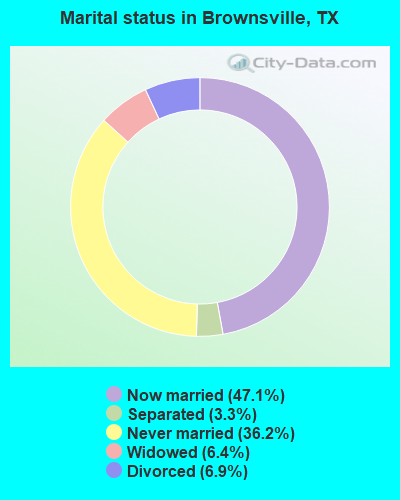
- Never married: 36.2%
- Now married: 47.1%
- Separated: 3.3%
- Widowed: 6.4%
- Divorced: 6.9%
For population 25 years and over in Brownsville:
- High school or higher: 71.2%
- Bachelor's degree or higher: 22.5%
- Graduate or professional degree: 6.0%
- Unemployed: 13.0%
- Mean travel time to work (commute): 19.2 minutes
| Here: | 20.4 |
| Texas average: | 14.0 |
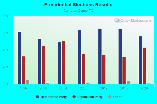
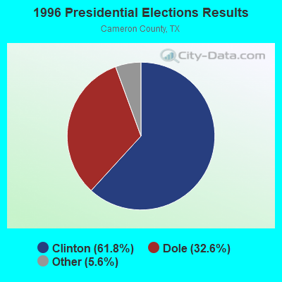
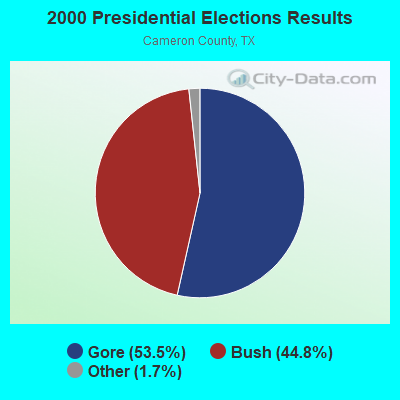
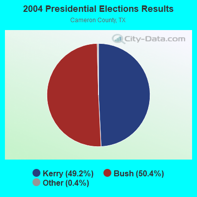
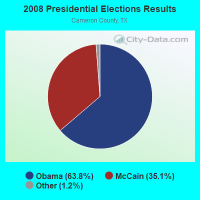
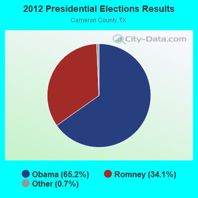
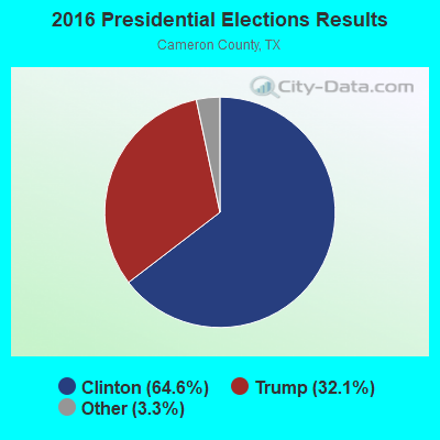
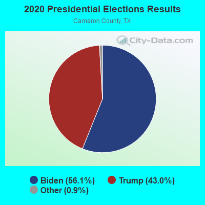
Graphs represent county-level data. Detailed 2008 Election Results
Neighborhoods in Brownsville:
(Brownsville, Texas Neighborhood Map)Religion statistics for Brownsville, TX (based on Cameron County data)
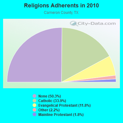
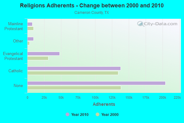
| Religion | Adherents | Congregations |
|---|---|---|
| Catholic | 137,889 | 38 |
| Evangelical Protestant | 47,744 | 225 |
| Other | 9,115 | 33 |
| Mainline Protestant | 7,258 | 32 |
| None | 204,214 | - |
Food Environment Statistics:
| Cameron County: | 1.22 / 10,000 pop. |
| Texas: | 1.47 / 10,000 pop. |
| Here: | 0.13 / 10,000 pop. |
| Texas: | 0.14 / 10,000 pop. |
| Cameron County: | 0.81 / 10,000 pop. |
| State: | 1.11 / 10,000 pop. |
| Cameron County: | 3.46 / 10,000 pop. |
| Texas: | 3.95 / 10,000 pop. |
| Cameron County: | 5.79 / 10,000 pop. |
| Texas: | 6.13 / 10,000 pop. |
| Cameron County: | 8.9% |
| Texas: | 8.9% |
| Cameron County: | 25.4% |
| State: | 26.6% |
| Cameron County: | 18.6% |
| State: | 15.7% |
Health and Nutrition:
| Brownsville: | 47.6% |
| Texas: | 48.6% |
| Brownsville: | 47.2% |
| Texas: | 47.4% |
| Brownsville: | 28.5 |
| Texas: | 28.5 |
| Brownsville: | 18.9% |
| State: | 20.6% |
| Brownsville: | 12.3% |
| Texas: | 10.3% |
| Here: | 6.9 |
| Texas: | 6.8 |
| This city: | 33.9% |
| Texas: | 33.1% |
| Brownsville: | 53.6% |
| Texas: | 56.2% |
| Brownsville: | 81.5% |
| Texas: | 80.7% |
More about Health and Nutrition of Brownsville, TX Residents
| Local government employment and payroll (March 2022) | |||||
| Function | Full-time employees | Monthly full-time payroll | Average yearly full-time wage | Part-time employees | Monthly part-time payroll |
|---|---|---|---|---|---|
| Other and Unallocable | 305 | $1,358,699 | $53,457 | 10 | $21,730 |
| Police Protection - Officers | 237 | $1,821,573 | $92,232 | 0 | $0 |
| Firefighters | 196 | $1,318,217 | $80,707 | 0 | $0 |
| Streets and Highways | 130 | $386,982 | $35,721 | 0 | $0 |
| Electric Power | 108 | $531,817 | $59,091 | 1 | $2,092 |
| Sewerage | 99 | $383,514 | $46,487 | 0 | $0 |
| Water Supply | 91 | $351,629 | $46,369 | 1 | $1,995 |
| Parks and Recreation | 69 | $172,134 | $29,936 | 21 | $21,319 |
| Police - Other | 69 | $215,399 | $37,461 | 3 | $2,298 |
| Transit | 66 | $222,365 | $40,430 | 2 | $3,255 |
| Other Government Administration | 59 | $286,994 | $58,372 | 8 | $3,554 |
| Health | 42 | $145,428 | $41,551 | 6 | $12,013 |
| Financial Administration | 37 | $150,961 | $48,960 | 3 | $2,739 |
| Local Libraries | 36 | $98,281 | $32,760 | 9 | $7,874 |
| Judicial and Legal | 34 | $151,320 | $53,407 | 4 | $8,488 |
| Solid Waste Management | 27 | $81,366 | $36,163 | 0 | $0 |
| Airports | 16 | $57,237 | $42,928 | 0 | $0 |
| Fire - Other | 10 | $27,470 | $32,964 | 0 | $0 |
| Housing and Community Development (Local) | 9 | $32,043 | $42,724 | 1 | $1,435 |
| Totals for Government | 1,640 | $7,793,429 | $57,025 | 69 | $88,792 |
Brownsville government finances - Expenditure in 2021 (per resident):
- Construction - Air Transportation: $34,961,000 ($184.61)
Parks and Recreation: $1,262,000 ($6.66)
General Public Buildings: $940,000 ($4.96)
Regular Highways: $315,000 ($1.66)
Sewerage: $112,000 ($0.59)
Transit Utilities: $92,000 ($0.49)
Health - Other: $15,000 ($0.08)
- Current Operations - Electric Utilities: $111,252,000 ($587.45)
Police Protection: $35,077,000 ($185.22)
Local Fire Protection: $21,609,000 ($114.10)
Water Utilities: $21,282,000 ($112.38)
Sewerage: $14,397,000 ($76.02)
Central Staff Services: $13,988,000 ($73.86)
General - Other: $11,772,000 ($62.16)
Health - Other: $11,133,000 ($58.79)
Regular Highways: $10,156,000 ($53.63)
Parks and Recreation: $9,112,000 ($48.11)
Transit Utilities: $6,714,000 ($35.45)
Financial Administration: $3,502,000 ($18.49)
Air Transportation: $3,468,000 ($18.31)
Libraries: $3,378,000 ($17.84)
Judicial and Legal Services: $2,895,000 ($15.29)
Housing and Community Development: $1,981,000 ($10.46)
Protective Inspection and Regulation - Other: $1,703,000 ($8.99)
Correctional Institutions: $725,000 ($3.83)
Parking Facilities: $414,000 ($2.19)
Public Welfare - Other: $402,000 ($2.12)
Solid Waste Management: $324,000 ($1.71)
General Public Buildings: $90,000 ($0.48)
- Electric Utilities - Interest on Debt: $7,530,000 ($39.76)
- General - Interest on Debt: $6,462,000 ($34.12)
- Intergovernmental to Local - Other - Housing and Community Development: $1,795,000 ($9.48)
- Other Capital Outlay - Regular Highways: $5,126,000 ($27.07)
Transit Utilities: $3,857,000 ($20.37)
Police Protection: $2,063,000 ($10.89)
Parks and Recreation: $774,000 ($4.09)
General Public Building: $430,000 ($2.27)
Air Transportation: $144,000 ($0.76)
Health - Other: $99,000 ($0.52)
- Total Salaries and Wages: $105,906,000 ($559.22)
- Water Utilities - Interest on Debt: $3,604,000 ($19.03)
Brownsville government finances - Revenue in 2021 (per resident):
- Charges - Sewerage: $23,358,000 ($123.34)
Solid Waste Management: $14,760,000 ($77.94)
Air Transportation: $2,802,000 ($14.80)
Other: $2,465,000 ($13.02)
Parks and Recreation: $481,000 ($2.54)
Parking Facilities: $314,000 ($1.66)
- Federal Intergovernmental - Transit Utilities: $5,376,000 ($28.39)
Housing and Community Development: $5,310,000 ($28.04)
Other: $3,912,000 ($20.66)
Air Transportation: $334,000 ($1.76)
- Local Intergovernmental - Other: $2,105,000 ($11.12)
- Miscellaneous - General Revenue - Other: $30,520,000 ($161.16)
Interest Earnings: $3,497,000 ($18.47)
Fines and Forfeits: $2,377,000 ($12.55)
Rents: $101,000 ($0.53)
- Revenue - Electric Utilities: $171,708,000 ($906.68)
Water Utilities: $25,983,000 ($137.20)
Transit Utilities: $1,198,000 ($6.33)
- State Intergovernmental - Other: $398,000 ($2.10)
General Local Government Support: $248,000 ($1.31)
Highways: $42,000 ($0.22)
- Tax - Property: $49,082,000 ($259.17)
General Sales and Gross Receipts: $31,230,000 ($164.90)
Public Utilities Sales: $4,346,000 ($22.95)
Occupation and Business License - Other: $1,799,000 ($9.50)
Other Selective Sales: $1,589,000 ($8.39)
Other License: $563,000 ($2.97)
Alcoholic Beverage License: $33,000 ($0.17)
Brownsville government finances - Debt in 2021 (per resident):
- Long Term Debt - Outstanding Nonguaranteed - Industrial Revenue: $268,999,000 ($1420.40)
Beginning Outstanding - Public Debt for Private Purpose: $236,608,000 ($1249.37)
Beginning Outstanding - Unspecified Public Purpose: $154,525,000 ($815.94)
Outstanding Unspecified Public Purpose: $153,115,000 ($808.50)
Issue, Nonguaranteed - Public Debt for Private Purpose: $109,729,000 ($579.41)
Retired Nonguaranteed - Public Debt for Private Purpose: $77,338,000 ($408.37)
Retired Unspecified Public Purpose: $27,260,000 ($143.94)
Issue, Unspecified Public Purpose: $25,850,000 ($136.50)
- Short Term Debt Outstanding - Beginning: $37,500,000 ($198.01)
Brownsville government finances - Cash and Securities in 2021 (per resident):
- Bond Funds - Cash and Securities: $22,835,000 ($120.58)
- Other Funds - Cash and Securities: $256,583,000 ($1354.84)
- Sinking Funds - Cash and Securities: $301,151,000 ($1590.18)
3.64% of this county's 2021 resident taxpayers lived in other counties in 2020 ($49,868 average adjusted gross income)
| Here: | 3.64% |
| Texas average: | 8.12% |
0.03% of residents moved from foreign countries ($558 average AGI)
Cameron County: 0.03% Texas average: 0.04%
Top counties from which taxpayers relocated into this county between 2020 and 2021:
| from Hidalgo County, TX | |
| from Harris County, TX | |
| from Bexar County, TX |
3.56% of this county's 2020 resident taxpayers moved to other counties in 2021 ($47,696 average adjusted gross income)
| Here: | 3.56% |
| Texas average: | 7.40% |
0.01% of residents moved to foreign countries ($366 average AGI)
Cameron County: 0.01% Texas average: 0.03%
Top counties to which taxpayers relocated from this county between 2020 and 2021:
| to Hidalgo County, TX | |
| to Bexar County, TX | |
| to Harris County, TX |
| Businesses in Brownsville, TX | ||||
| Name | Count | Name | Count | |
|---|---|---|---|---|
| ALDO | 1 | La Quinta | 1 | |
| AT&T | 2 | La-Z-Boy | 1 | |
| Academy Sports + Outdoors | 1 | Lane Bryant | 1 | |
| Advance Auto Parts | 4 | Lane Furniture | 1 | |
| Aeropostale | 1 | Little Caesars Pizza | 1 | |
| American Eagle Outfitters | 1 | Long John Silver's | 1 | |
| Ashley Furniture | 1 | Lowe's | 1 | |
| AutoZone | 8 | Marriott | 2 | |
| Avenue | 1 | Marshalls | 1 | |
| Bath & Body Works | 1 | McDonald's | 11 | |
| Bebe | 1 | Motel 6 | 2 | |
| Bed Bath & Beyond | 1 | Motherhood Maternity | 1 | |
| Blockbuster | 1 | New York & Co | 1 | |
| Burger King | 7 | Nike | 12 | |
| Burlington Coat Factory | 1 | Nissan | 1 | |
| CVS | 4 | Office Depot | 1 | |
| Charlotte Russe | 1 | Old Navy | 1 | |
| Chevrolet | 1 | Pac Sun | 1 | |
| Chick-Fil-A | 2 | Panda Express | 1 | |
| Chuck E. Cheese's | 1 | Payless | 7 | |
| Church's Chicken | 8 | Penske | 1 | |
| Comfort Suites | 1 | PetSmart | 1 | |
| Cricket Wireless | 35 | Quiznos | 2 | |
| DHL | 2 | RadioShack | 4 | |
| Days Inn | 1 | Red Lobster | 1 | |
| Dennys | 2 | Rue21 | 1 | |
| Discount Tire | 1 | SAS Shoes | 1 | |
| Domino's Pizza | 2 | SONIC Drive-In | 2 | |
| DressBarn | 1 | Sam's Club | 1 | |
| Dressbarn | 1 | Sears | 2 | |
| El Pollo Loco | 1 | Sephora | 1 | |
| Express | 1 | Shoe Carnival | 1 | |
| FedEx | 16 | Spencer Gifts | 1 | |
| Firestone Complete Auto Care | 1 | Sprint Nextel | 3 | |
| Foot Locker | 1 | Staples | 1 | |
| GNC | 2 | Starbucks | 2 | |
| GameStop | 3 | Subway | 6 | |
| Gap | 1 | Super 8 | 1 | |
| Goodwill | 1 | T-Mobile | 8 | |
| H&R Block | 5 | T.J.Maxx | 1 | |
| Hilton | 1 | Taco Bell | 1 | |
| Holiday Inn | 3 | Target | 1 | |
| Home Depot | 2 | U-Haul | 3 | |
| Hot Topic | 1 | UPS | 13 | |
| JCPenney | 1 | Vans | 3 | |
| Jack In The Box | 4 | Verizon Wireless | 1 | |
| Jones New York | 2 | Victoria's Secret | 1 | |
| Journeys | 1 | Volkswagen | 1 | |
| Justice | 1 | Walgreens | 3 | |
| KFC | 3 | Walmart | 3 | |
| Kmart | 1 | Wendy's | 3 | |
| Kohl's | 1 | |||
Strongest AM radio stations in Brownsville:
- KBOR (1600 AM; 10 kW; BROWNSVILLE, TX; Owner: LA NUEVA KBOR, INC.)
- KQXX (1700 AM; 10 kW; BROWNSVILLE, TX; Owner: LA NUEVA KBOR, INC.)
- KGBT (1530 AM; 50 kW; HARLINGEN, TX; Owner: TICHENOR LICENSE CORPORATION)
- KURV (710 AM; 10 kW; EDINBURG, TX; Owner: VOICE OF VALLEY AGRICULTURE, INC.)
- KUBR (1210 AM; 10 kW; SAN JUAN, TX; Owner: PAULINO BERNAL)
- KRGE (1290 AM; 5 kW; WESLACO, TX; Owner: CHRISTIAN MINISTRIES OF THE VALLEY)
- KVJY (840 AM; 5 kW; PHARR, TX; Owner: RADIO UNICA OF MCALLEN LICENSE CORP.)
- KCTA (1030 AM; 50 kW; CORPUS CHRISTI, TX; Owner: BROADCASTING CORPORATION OF THE SOUTHWEST)
- KRIO (910 AM; 5 kW; MCALLEN, TX; Owner: RIO GRANDE BIBLE INSTITUTE, INC.)
- KKYX (680 AM; 50 kW; SAN ANTONIO, TX; Owner: CXR HOLDINGS, INC.)
- KTKR (760 AM; 50 kW; SAN ANTONIO, TX; Owner: CCB TEXAS LICENSES, L.P.)
- WOAI (1200 AM; 50 kW; SAN ANTONIO, TX; Owner: CCB TEXAS LICENSES, L.P.)
- KTRH (740 AM; 50 kW; HOUSTON, TX; Owner: AMFM TEXAS LICENSES LIMITED PARTNERSHIP)
Strongest FM radio stations in Brownsville:
- KBNR (88.3 FM; BROWNSVILLE, TX; Owner: WORLD RADIO NETWORK, INC.)
- KTEX (100.3 FM; BROWNSVILLE, TX; Owner: CAPSTAR TX LIMITED PARTNERSHIP)
- KVMV (96.9 FM; MCALLEN, TX; Owner: WORLD RADIO NETWORK, INC.)
- KBFM (104.1 FM; EDINBURG, TX; Owner: CAPSTAR TX LIMITED PARTNERSHIP)
- KGBT-FM (98.5 FM; MCALLEN, TX; Owner: TICHENOR LICENSE CORPORATION ("TLC"))
- KFRQ (94.5 FM; HARLINGEN, TX; Owner: ENTRAVISION HOLDINGS, L.L.C.)
- KKPS (99.5 FM; BROWNSVILLE, TX; Owner: ENTRAVISION HOLDINGS, L.L.C.)
- KBTQ (96.1 FM; HARLINGEN, TX; Owner: TICHENOR LICENSE CORPORATION ("TLC"))
- KNVO-FM (101.1 FM; PORT ISABEL, TX; Owner: ENTRAVISION HOLDINGS, L.L.C.)
- KESO (92.7 FM; SOUTH PADRE ISLAND, TX; Owner: ALTERNATIVE BROADCASTING CORPORATION)
- KVLY (107.9 FM; EDINBURG, TX; Owner: ENTRAVISION HOLDINGS, L.L.C.)
- KMAZ (106.3 FM; MERCEDES, TX; Owner: LA NUEVA KBOR, INC.)
- KMBH-FM (88.9 FM; HARLINGEN, TX; Owner: RGV EDUCATIONAL BROADCASTING, INC.)
- KZSP (95.3 FM; SOUTH PADRE ISLAND, TX; Owner: ALTERNATIVE BROADCASTING CORPORATION)
TV broadcast stations around Brownsville:
- KZAV-LP (Channel 20; BROWNSVILLE, TX; Owner: ZAVALETTA BROADCASTING OF THE RIO GRANDE VALLEY, LLC)
- KXIV-LP (Channel 17; BROWNSVILLE, TX; Owner: FAITH PLEASES GOD CHURCH CORP.)
- KRGV-TV (Channel 5; WESLACO, TX; Owner: MOBILE VIDEO TAPES, INC.)
- KVEO (Channel 23; BROWNSVILLE, TX; Owner: COMCORP OF TEXAS LICENSE CORP.)
- KMBH (Channel 60; HARLINGEN, TX; Owner: RGV EDUCATIONAL BROADCASTING, INC.)
- KGBT-TV (Channel 4; HARLINGEN, TX; Owner: LIBCO, INC.)
- K64FM (Channel 64; BROWNSVILLE, TX; Owner: BROWNSVILLE BROADCASTING, LLC)
- KLUJ (Channel 44; HARLINGEN, TX; Owner: COMMUNITY EDUCATIONAL TELEVISION)
- KTIZ-LP (Channel 52; HARLINGEN, TX; Owner: ORTIZ BROADCASTING CORPORATION)
- KNVO (Channel 48; Mc ALLEN, TX; Owner: ENTRAVISION HOLDINGS, LLC)
- KTLM (Channel 40; RIO GRANDE CITY, TX; Owner: SUNBELT MULTIMEDIA CO.)
- KFTN-LP (Channel 30; La FERIA, TX; Owner: ORTIZ BROADCASTING CORPORATION)
- National Bridge Inventory (NBI) Statistics
- 191Number of bridges
- 4,993ft / 1,522mTotal length
- $383,000Total costs
- 2,373,966Total average daily traffic
- 195,625Total average daily truck traffic
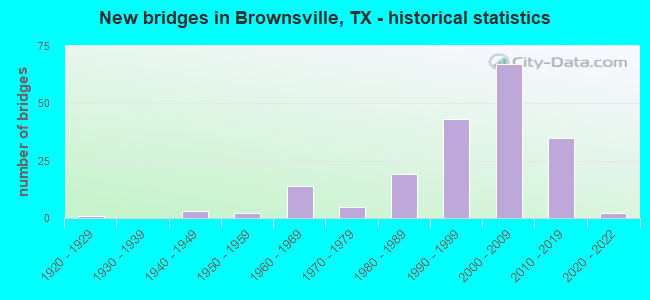
- New bridges - historical statistics
- 11920-1929
- 31940-1949
- 21950-1959
- 141960-1969
- 51970-1979
- 191980-1989
- 431990-1999
- 672000-2009
- 352010-2019
- 22020-2022
FCC Registered Antenna Towers: 595 (See the full list of FCC Registered Antenna Towers)
FCC Registered Commercial Land Mobile Towers: 2 (See the full list of FCC Registered Commercial Land Mobile Towers in Brownsville, TX)
FCC Registered Private Land Mobile Towers: 9 (See the full list of FCC Registered Private Land Mobile Towers)
FCC Registered Broadcast Land Mobile Towers: 53 (See the full list of FCC Registered Broadcast Land Mobile Towers)
FCC Registered Microwave Towers: 80 (See the full list of FCC Registered Microwave Towers in this town)
FCC Registered Paging Towers: 16 (See the full list of FCC Registered Paging Towers)
FCC Registered Maritime Coast & Aviation Ground Towers: 24 (See the full list of FCC Registered Maritime Coast & Aviation Ground Towers)
FCC Registered Amateur Radio Licenses: 220 (See the full list of FCC Registered Amateur Radio Licenses in Brownsville)
FAA Registered Aircraft Manufacturers and Dealers: 7 (See the full list of FAA Registered Manufacturers and Dealers in Brownsville)
FAA Registered Aircraft: 60 (See the full list of FAA Registered Aircraft)
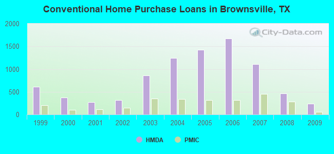
| Home Mortgage Disclosure Act Aggregated Statistics For Year 2009 (Based on 42 full and 6 partial tracts) | ||||||||||||||
| A) FHA, FSA/RHS & VA Home Purchase Loans | B) Conventional Home Purchase Loans | C) Refinancings | D) Home Improvement Loans | E) Loans on Dwellings For 5+ Families | F) Non-occupant Loans on < 5 Family Dwellings (A B C & D) | G) Loans On Manufactured Home Dwelling (A B C & D) | ||||||||
|---|---|---|---|---|---|---|---|---|---|---|---|---|---|---|
| Number | Average Value | Number | Average Value | Number | Average Value | Number | Average Value | Number | Average Value | Number | Average Value | Number | Average Value | |
| LOANS ORIGINATED | 476 | $103,436 | 235 | $111,962 | 484 | $115,573 | 123 | $33,363 | 7 | $293,000 | 79 | $79,669 | 3 | $19,490 |
| APPLICATIONS APPROVED, NOT ACCEPTED | 41 | $109,490 | 31 | $90,057 | 153 | $90,690 | 39 | $36,038 | 0 | $0 | 20 | $76,114 | 2 | $50,500 |
| APPLICATIONS DENIED | 60 | $110,570 | 105 | $85,738 | 702 | $77,719 | 530 | $26,693 | 1 | $215,000 | 77 | $56,992 | 15 | $51,243 |
| APPLICATIONS WITHDRAWN | 51 | $103,097 | 24 | $125,459 | 234 | $98,900 | 71 | $46,824 | 0 | $0 | 20 | $63,100 | 3 | $96,667 |
| FILES CLOSED FOR INCOMPLETENESS | 14 | $100,009 | 10 | $101,301 | 56 | $105,530 | 23 | $31,792 | 0 | $0 | 8 | $74,250 | 2 | $43,500 |
Detailed mortgage data for all 48 tracts in Brownsville, TX
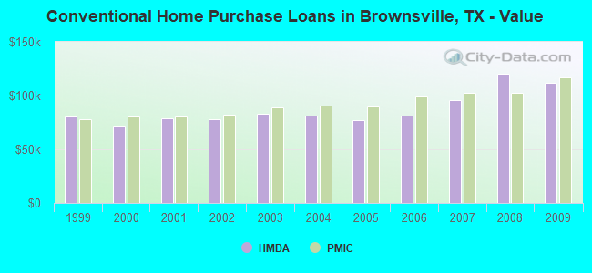
| Private Mortgage Insurance Companies Aggregated Statistics For Year 2009 (Based on 28 full and 4 partial tracts) | ||||||
| A) Conventional Home Purchase Loans | B) Refinancings | C) Non-occupant Loans on < 5 Family Dwellings (A & B) | ||||
|---|---|---|---|---|---|---|
| Number | Average Value | Number | Average Value | Number | Average Value | |
| LOANS ORIGINATED | 52 | $116,550 | 33 | $152,909 | 2 | $77,000 |
| APPLICATIONS APPROVED, NOT ACCEPTED | 14 | $117,409 | 13 | $143,135 | 0 | $0 |
| APPLICATIONS DENIED | 7 | $136,507 | 15 | $147,291 | 1 | $101,000 |
| APPLICATIONS WITHDRAWN | 7 | $95,571 | 5 | $111,200 | 1 | $46,000 |
| FILES CLOSED FOR INCOMPLETENESS | 2 | $172,500 | 1 | $156,000 | 0 | $0 |
2004 - 2018 National Fire Incident Reporting System (NFIRS) incidents
- Fire incident types reported to NFIRS in Brownsville, TX
- 3,54149.8%Outside Fires
- 1,78025.0%Structure Fires
- 1,42720.1%Mobile Property/Vehicle Fires
- 3675.2%Other
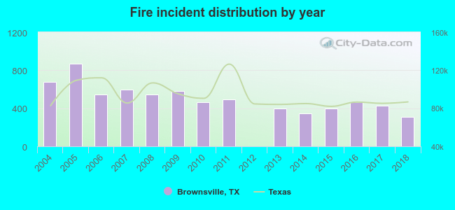 Based on the data from the years 2004 - 2018 the average number of fire incidents per year is 474. The highest number of fires - 872 took place in 2005, and the least - 2 in 2012. The data has a dropping trend.
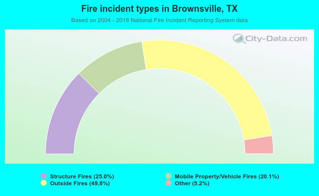 When looking into fire subcategories, the most reports belonged to: Outside Fires (49.8%), and Structure Fires (25.0%).
Fire-safe hotels and motels in Brownsville, Texas:
- Holiday Inn Full Service Hotel, 3777 North Expy 83, Brownsville, Texas 78520 , Phone: (956) 547-1500, Fax: (956) 547-1550
- Holiday Inn Express Hotel, 1985 N Expy, Brownsville, Texas 78520 , Phone: (956) 550-0666, Fax: (956) 550-9449
- Americas Best Value Inn, 825 N Expy 83, Brownsville, Texas 78520 , Phone: (956) 504-3331, Fax: (956) 546-0379
- Homewood Suites By Hilton, 3759 N Expy, Brownsville, Texas 78520 , Phone: (956) 574-6900, Fax: (956) 574-6910
- Red Roof Inn - Brownsville, 2377 N Expy 83, Brownsville, Texas 78520 , Phone: (956) 504-2300, Fax: (956) 504-2303
- Staybridge Suites - Brownsville, 2900 Pablo Kisel Blvd, Brownsville, Texas 78526 , Phone: (956) 504-9500, Fax: (956) 504-9584
- Hampton Inn & Suites, 3000 North Expy 77/83, Brownsville, Texas 78526 , Phone: (956) 548-0005, Fax: (956) 504-9793
- Courtyard Marriott, 3955 N Expy 77/83, Brownsville, Texas 78520 , Phone: (956) 350-4600, Fax: (956) 350-4678
- 7 other hotels and motels
| Most common first names in Brownsville, TX among deceased individuals | ||
| Name | Count | Lived (average) |
|---|---|---|
| Maria | 1,149 | 75.5 years |
| Jose | 711 | 70.5 years |
| Guadalupe | 470 | 75.6 years |
| Juan | 369 | 70.5 years |
| Manuel | 272 | 74.2 years |
| Jesus | 207 | 70.7 years |
| Francisco | 200 | 73.0 years |
| Antonio | 195 | 72.9 years |
| Pedro | 183 | 74.1 years |
| John | 169 | 73.3 years |
| Most common last names in Brownsville, TX among deceased individuals | ||
| Last name | Count | Lived (average) |
|---|---|---|
| Garcia | 723 | 74.2 years |
| Garza | 482 | 72.9 years |
| Rodriguez | 456 | 72.5 years |
| Gonzalez | 430 | 72.1 years |
| Martinez | 380 | 73.6 years |
| Hernandez | 359 | 73.5 years |
| Perez | 282 | 72.6 years |
| Lopez | 279 | 72.2 years |
| Ramirez | 221 | 73.9 years |
| Flores | 215 | 74.3 years |
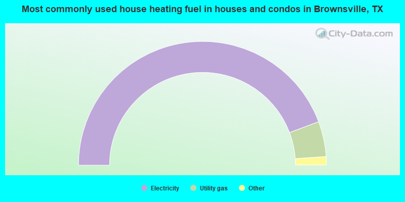
- 88.6%Electricity
- 9.2%Utility gas
- 1.1%Bottled, tank, or LP gas
- 0.9%No fuel used
- 0.1%Wood
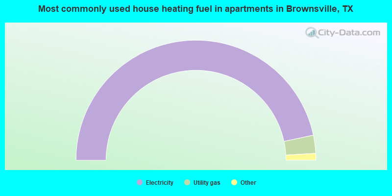
- 93.3%Electricity
- 4.9%Utility gas
- 1.0%No fuel used
- 0.6%Bottled, tank, or LP gas
- 0.1%Other fuel
Brownsville compared to Texas state average:
- Median household income below state average.
- Median house value below state average.
- Black race population percentage significantly below state average.
- Hispanic race population percentage significantly above state average.
- Foreign-born population percentage significantly above state average.
Brownsville, TX compared to other similar cities:
Brownsville on our top lists:
- #4 on the list of "Top 101 cities with largest percentage of females in occupations: sales and related occupations (population 50,000+)"
- #10 on the list of "Top 100 least racially diverse cities (pop. 50,000+)"
- #12 on the list of "Top 101 cities with the lowest percentage of English-only speaking households, population 50,000+"
- #12 on the list of "Top 101 cities with the highest percentage of family households, population 100,000+"
- #14 on the list of "Top 101 cities with largest percentage of females in occupations: health technologists and technicians (population 50,000+)"
- #19 on the list of "Top 101 cities with largest percentage of males in occupations: health diagnosing and treating practitioners and other technical occupations (population 50,000+)"
- #23 on the list of "Top 101 cities with the smallest percentages of current college students (population 100,000+)"
- #23 on the list of "Top 101 cities with largest percentage of males in industries: health care and social assistance (population 50,000+)"
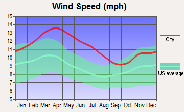
- #39 on the list of "Top 101 cities with the largest wind speed differences during a year (population 50,000+)"
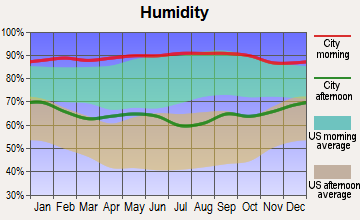
- #43 on the list of "Top 101 cities with the highest average humidity (population 50,000+)"
- #44 on the list of "Top 101 cities with the largest city-data.com crime index decrease from 2002 to 2012 (population 50,000+)"
- #45 on the list of "Top 100 least-educated cities (pop. 50,000+)"
- #46 on the list of "Top 101 cities with largest percentage of males in occupations: education, training, and library occupations (population 50,000+)"
- #48 on the list of "Top 101 cities with the lowest cost per building permit (population 50,000+)"
- #50 on the list of "Top 101 cities with largest percentage of males in industries: mining, quarrying, and oil and gas extraction (population 50,000+)"
- #55 on the list of "Top 101 cities with largest percentage of females in occupations: education, training, and library occupations (population 50,000+)"
- #55 on the list of "Top 101 cities with largest percentage of males in occupations: healthcare support occupations (population 50,000+)"
- #63 on the list of "Top 101 cities with the highest average temperatures (population 50,000+)"
- #64 on the list of "Top 101 cities with the highest number of thefts per 100,000 residents, excludes tourist destinations and others with a lot of outsiders visiting based on city industries data (population 50,000+)"
- #66 on the list of "Top 101 cities with largest percentage of females in industries: educational services (population 50,000+)"
- #8 on the list of "Top 101 counties with the highest number of births per 1000 residents 2007-2013"
- #13 on the list of "Top 101 counties with the largest increase in the number of infant deaths per 1000 residents 2000-2006 to 2007-2013 (pop. 50,000+)"
- #24 on the list of "Top 101 counties with the largest decrease in the number of births per 1000 residents 2000-2006 to 2007-2013 (pop 50,000+)"
- #49 on the list of "Top 101 counties with the lowest percentage of residents relocating to other counties in 2011"
- #59 on the list of "Top 101 counties with the lowest percentage of residents relocating from other counties between 2010 and 2011 (pop. 50,000+)"

|
|
Total of 41 patent applications in 2008-2024.