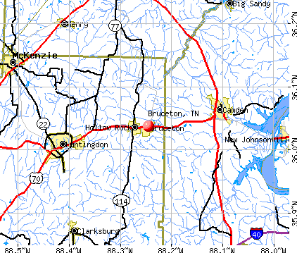
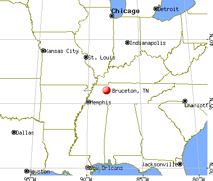
Bruceton, Tennessee

Bruceton: Looking westward down Bruceton-CSX Switch Yard.
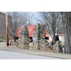
Bruceton: Downtown Templeton Park Gateway
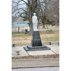
Bruceton: Memorial to Mayor Sam Siegel
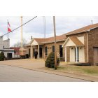
Bruceton: Bruceton City Hall & Police Dept.
- add
your
Submit your own pictures of this town and show them to the world
- OSM Map
- General Map
- Google Map
- MSN Map
Population change since 2000: -3.6%
 |
| Males: 717 | |
| Females: 781 |
| Median resident age: | 49.4 years |
| Tennessee median age: | 39.2 years |
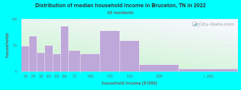
| Bruceton: | $55,782 |
| TN: | $65,254 |
Estimated per capita income in 2022: $27,850 (it was $15,711 in 2000)
Bruceton town income, earnings, and wages data
Estimated median house or condo value in 2022: $116,816 (it was $46,800 in 2000)
| Bruceton: | $116,816 |
| TN: | $284,800 |
Mean prices in 2022: all housing units: $242,357; detached houses: $247,027; mobile homes: $49,811
Median gross rent in 2022: $691.
(16.0% for White Non-Hispanic residents, 20.7% for Black residents, 53.3% for Hispanic or Latino residents, 33.3% for two or more races residents)
Detailed information about poverty and poor residents in Bruceton, TN
Compare current foreclosures near Bruceton, TN:
| Photo | Address | Area | Beds / Baths | Price | Details |
|---|---|---|---|---|---|

|
#1
Wyatt St N
Bruceton, TN 38317
|
660 sq. feet
|
1 baths - beds |
show details | |

|
#2
Ash St
Bruceton, TN 38317
|
1,296 sq. feet
|
1 baths - beds |
show details | |

|
#3
Cheatham St
Bruceton, TN 38317
|
784 sq. feet
|
1 baths - beds |
show details | |

|
#4
Highland St
Bruceton, TN 38317
|
- sq. feet
|
- baths - beds |
show details | |

|
#5
Bruceton Vale Rd
Bruceton, TN 38317
|
- sq. feet
|
- baths - beds |
show details | |

|
#6
Main St
Hollow Rock, TN 38342
|
- sq. feet
|
- baths - beds |
show details | |

|
#7
Carroll St N
Bruceton, TN 38317
|
- sq. feet
|
- baths - beds |
show details | |

|
#8
Guins Creek Ln
Mc Kenzie, TN 38201
|
2,204 sq. feet
|
2 baths 3 beds |
$199,000
|
show details |

|
#9
Pettijohn Creek Rd
Henry, TN 38231
|
- sq. feet
|
2 baths 3 beds |
$94,900
|
show details |

|
#10
Highway 436
Mc Kenzie, TN 38201
|
1,680 sq. feet
|
2 baths 3 beds |
show details |
| Photo | Address | Area | Beds / Baths | Price | Details |
|---|---|---|---|---|---|

|
#11
Paris St
Huntingdon, TN 38344
|
1,768 sq. feet
|
3 baths 3 beds |
show details | |

|
#12
David St
Mc Kenzie, TN 38201
|
1,680 sq. feet
|
2 baths 3 beds |
show details | |

|
#13
Northwood Dr
Huntingdon, TN 38344
|
2,004 sq. feet
|
2 baths 3 beds |
show details | |

|
#14
Callahan Dr
New Johnsonville, TN 37134
|
2,548 sq. feet
|
2 baths - beds |
show details | |

|
#15
Vernon Thomas Rd
Mc Kenzie, TN 38201
|
2,109 sq. feet
|
2 baths - beds |
show details | |

|
#16
High St
Huntingdon, TN 38344
|
1,069 sq. feet
|
1 baths - beds |
show details | |

|
#17
Northwood Dr
Huntingdon, TN 38344
|
1,783 sq. feet
|
2 baths - beds |
show details | |

|
#18
Browning Ave
Huntingdon, TN 38344
|
980 sq. feet
|
1 baths - beds |
show details | |

|
#19
Shiloh Church Rd
Mansfield, TN 38236
|
1,394 sq. feet
|
1 baths - beds |
show details | |

|
#20
Ledsinger Rd
Huntingdon, TN 38344
|
1,248 sq. feet
|
1 baths - beds |
show details |
| Photo | Address | Area | Beds / Baths | Price | Details |
|---|---|---|---|---|---|

|
#21
Chestnut Ave
Mc Kenzie, TN 38201
|
824 sq. feet
|
1 baths - beds |
show details | |

|
#22
Smith Ave
Mc Kenzie, TN 38201
|
928 sq. feet
|
1 baths - beds |
show details | |

|
#23
Purdy Rd
Huntingdon, TN 38344
|
2,214 sq. feet
|
2 baths - beds |
show details | |

|
#24
Ball Park Rd
Big Sandy, TN 38221
|
1,056 sq. feet
|
1 baths - beds |
show details | |

|
#25
Tate School Rd
Huntingdon, TN 38344
|
1,189 sq. feet
|
1 baths - beds |
show details | |

|
#26
Swor Rd
Springville, TN 38256
|
1,717 sq. feet
|
1 baths - beds |
show details | |

|
#27
Highway 436
Mc Kenzie, TN 38201
|
1,680 sq. feet
|
2 baths - beds |
show details | |

|
#28
Highway 22
Huntingdon, TN 38344
|
1,680 sq. feet
|
1 baths - beds |
show details | |

|
#29
Mallard Ln
Yuma, TN 38390
|
1,404 sq. feet
|
1 baths - beds |
show details | |

|
#30
Oswalt Ln
Holladay, TN 38341
|
1,789 sq. feet
|
2 baths - beds |
show details |
| Photo | Address | Area | Beds / Baths | Price | Details |
|---|---|---|---|---|---|

|
#31
Holland Rd
Big Sandy, TN 38221
|
960 sq. feet
|
1 baths - beds |
show details | |

|
#32
Old Mckenzie Rd
Mc Kenzie, TN 38201
|
1,460 sq. feet
|
2 baths - beds |
show details | |

|
#33
Foust Rd
Mansfield, TN 38236
|
1,904 sq. feet
|
2 baths - beds |
show details | |

|
#34
Paris Pike
Mc Kenzie, TN 38201
|
1,801 sq. feet
|
1 baths - beds |
show details | |

|
#35
Clifty Village Ln
Paris, TN 38242
|
1,856 sq. feet
|
2 baths - beds |
show details | |

|
#36
Ben Smith Rd
Mc Kenzie, TN 38201
|
1,856 sq. feet
|
1 baths - beds |
show details | |

|
#37
Clifty Rd
Paris, TN 38242
|
1,728 sq. feet
|
2 baths - beds |
show details | |

|
#38
Foote Ln
New Johnsonville, TN 37134
|
1,380 sq. feet
|
1 baths - beds |
show details | |

|
#39
Reynoldsburg Rd
Springville, TN 38256
|
1,036 sq. feet
|
1 baths - beds |
show details | |

|
#40
Post Oak Ave
Camden, TN 38320
|
968 sq. feet
|
1 baths - beds |
show details |
| Photo | Address | Area | Beds / Baths | Price | Details |
|---|---|---|---|---|---|

|
#41
Stigall Rd
Camden, TN 38320
|
1,616 sq. feet
|
2 baths - beds |
show details | |

|
#42
Rowsey St
Camden, TN 38320
|
1,296 sq. feet
|
1 baths - beds |
show details | |

|
#43
Oakdale Rd
Camden, TN 38320
|
864 sq. feet
|
1 baths - beds |
show details | |

|
#44
Ephesus Church Rd
Hollow Rock, TN 38342
|
2,020 sq. feet
|
1 baths - beds |
show details | |

|
#45
Cedar Dr
Camden, TN 38320
|
1,508 sq. feet
|
1 baths - beds |
show details | |

|
#46
Northwood Dr
Huntingdon, TN 38344
|
1,418 sq. feet
|
2 baths - beds |
show details | |

|
#47
Highway 219
Huntingdon, TN 38344
|
1,736 sq. feet
|
1 baths - beds |
show details | |

|
#48
Washington Ave
Camden, TN 38320
|
1,050 sq. feet
|
1 baths - beds |
show details | |

|
#49
Smyrna Rd
Huntingdon, TN 38344
|
1,040 sq. feet
|
1 baths - beds |
show details | |

|
Check over 1 million property listings on Foreclosure.com!
|
browse all offers | |||


- 1,22291.5%White alone
- 604.5%Two or more races
- 382.8%Black alone
- 161.2%Hispanic
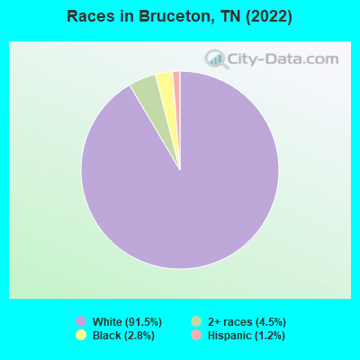
Races in Bruceton detailed stats: ancestries, foreign born residents, place of birth
According to our research of Tennessee and other state lists, there were 5 registered sex offenders living in Bruceton, Tennessee as of April 27, 2024.
The ratio of all residents to sex offenders in Bruceton is 310 to 1.
The ratio of registered sex offenders to all residents in this city is near the state average.
Type |
2009 |
2010 |
2011 |
2012 |
2013 |
2014 |
2015 |
2016 |
2017 |
2018 |
2019 |
2020 |
2021 |
2022 |
|---|---|---|---|---|---|---|---|---|---|---|---|---|---|---|
| Murders (per 100,000) | 0 (0.0) | 0 (0.0) | 0 (0.0) | 0 (0.0) | 0 (0.0) | 0 (0.0) | 0 (0.0) | 0 (0.0) | 0 (0.0) | 0 (0.0) | 0 (0.0) | 0 (0.0) | 0 (0.0) | 0 (0.0) |
| Rapes (per 100,000) | 0 (0.0) | 0 (0.0) | 1 (67.1) | 0 (0.0) | 0 (0.0) | 1 (68.6) | 0 (0.0) | 0 (0.0) | 0 (0.0) | 0 (0.0) | 0 (0.0) | 1 (72.1) | 0 (0.0) | 0 (0.0) |
| Robberies (per 100,000) | 0 (0.0) | 0 (0.0) | 0 (0.0) | 0 (0.0) | 0 (0.0) | 0 (0.0) | 0 (0.0) | 0 (0.0) | 0 (0.0) | 0 (0.0) | 0 (0.0) | 0 (0.0) | 0 (0.0) | 0 (0.0) |
| Assaults (per 100,000) | 8 (555.9) | 1 (67.7) | 17 (1,140) | 3 (201.9) | 1 (68.8) | 8 (549.1) | 6 (414.4) | 6 (420.8) | 2 (140.2) | 4 (285.1) | 5 (357.1) | 0 (0.0) | 1 (72.3) | 2 (133.7) |
| Burglaries (per 100,000) | 7 (486.4) | 5 (338.3) | 9 (603.6) | 6 (403.8) | 7 (481.4) | 4 (274.5) | 5 (345.3) | 8 (561.0) | 4 (280.3) | 7 (498.9) | 5 (357.1) | 7 (504.7) | 1 (72.3) | 1 (66.8) |
| Thefts (per 100,000) | 13 (903.4) | 13 (879.6) | 17 (1,140) | 16 (1,077) | 15 (1,032) | 16 (1,098) | 18 (1,243) | 35 (2,454) | 15 (1,051) | 12 (855.3) | 16 (1,143) | 8 (576.8) | 5 (361.5) | 16 (1,070) |
| Auto thefts (per 100,000) | 3 (208.5) | 2 (135.3) | 0 (0.0) | 0 (0.0) | 2 (137.6) | 1 (68.6) | 0 (0.0) | 1 (70.1) | 1 (70.1) | 0 (0.0) | 4 (285.7) | 1 (72.1) | 1 (72.3) | 4 (267.4) |
| Arson (per 100,000) | 0 (0.0) | 0 (0.0) | 1 (67.1) | 0 (0.0) | 1 (68.8) | 0 (0.0) | 0 (0.0) | 0 (0.0) | 0 (0.0) | 0 (0.0) | 0 (0.0) | 0 (0.0) | 0 (0.0) | 0 (0.0) |
| City-Data.com crime index | 198.1 | 83.2 | 369.6 | 111.7 | 99.7 | 233.4 | 156.8 | 227.2 | 95.3 | 126.2 | 165.0 | 121.8 | 39.8 | 95.6 |
The City-Data.com crime index weighs serious crimes and violent crimes more heavily. Higher means more crime, U.S. average is 246.1. It adjusts for the number of visitors and daily workers commuting into cities.
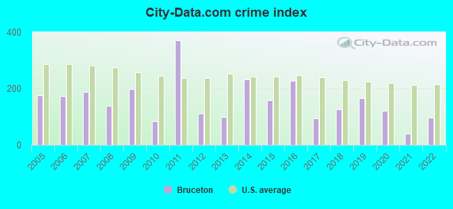
Crime rate in Bruceton detailed stats: murders, rapes, robberies, assaults, burglaries, thefts, arson
Full-time law enforcement employees in 2021, including police officers: 5 (5 officers - 5 male; 0 female).
| Officers per 1,000 residents here: | 3.62 |
| Tennessee average: | 2.57 |
 Recent articles from our blog. Our writers, many of them Ph.D. graduates or candidates, create easy-to-read articles on a wide variety of topics.

 | Looking for a small safe town in Tennessee to raise our kids (13 replies) |
| Top Tennessee High Schools (10 replies) |
| Want to start fresh in a small town...Suggestions? (29 replies) |
| railroad jobs (6 replies) |
Latest news from Bruceton, TN collected exclusively by city-data.com from local newspapers, TV, and radio stations
Ancestries: American (59.1%), English (6.8%), Italian (4.3%), Irish (3.2%), German (2.1%), Scotch-Irish (1.1%).
Current Local Time: CST time zone
Incorporated in 1925
Elevation: 412 feet
Land area: 1.94 square miles.
Population density: 772 people per square mile (low).
1 resident is foreign born
| This town: | 0.1% |
| Tennessee: | 2.8% |
Median real estate property taxes paid for housing units with mortgages in 2022: $872 (0.7%)
Median real estate property taxes paid for housing units with no mortgage in 2022: $1,030 (1.0%)
Nearest city with pop. 50,000+: Jackson, TN  (42.7 miles , pop. 59,643).
Nearest city with pop. 200,000+: Metropolitan Government, TN (83.1 miles , pop. 569,891).
Nearest city with pop. 1,000,000+: Chicago, IL (402.6 miles , pop. 2,896,016).
Nearest cities:
), ), ), )Latitude: 36.04 N, Longitude: 88.25 W
Area code: 731
Single-family new house construction building permits:
- 2022: 2 buildings, average cost: $175,000
- 2021: 2 buildings, average cost: $95,000
- 2018: 1 building, cost: $125,000
- 2016: 1 building, cost: $125,000
- 2015: 2 buildings, average cost: $133,500
- 2014: 1 building, cost: $65,000
- 2013: 2 buildings, average cost: $73,500
- 2005: 1 building, cost: $245,000
- 2003: 3 buildings, average cost: $141,700
- 2002: 1 building, cost: $115,000
- 2001: 2 buildings, average cost: $119,300
- 2000: 2 buildings, average cost: $119,500
- 1997: 1 building, cost: $128,000
| Here: | 3.7% |
| Tennessee: | 3.0% |
- Health care (13.1%)
- Metal & metal products (8.8%)
- Educational services (8.6%)
- Apparel (7.0%)
- Accommodation & food services (4.9%)
- Finance & insurance (4.7%)
- Construction (4.4%)
- Metal & metal products (13.9%)
- Construction (8.5%)
- Apparel (7.6%)
- Truck transportation (6.6%)
- Educational services (6.0%)
- Machinery (5.4%)
- Rail transportation (5.0%)
- Health care (25.3%)
- Educational services (11.5%)
- Finance & insurance (8.4%)
- Accommodation & food services (8.4%)
- Apparel (6.4%)
- Metal & metal products (3.4%)
- Machinery (2.7%)
- Other production occupations, including supervisors (6.2%)
- Metal workers and plastic workers (6.2%)
- Driver/sales workers and truck drivers (5.1%)
- Material recording, scheduling, dispatching, and distributing workers (4.4%)
- Assemblers and fabricators (4.1%)
- Preschool, kindergarten, elementary, and middle school teachers (3.8%)
- Electrical equipment mechanics and other installation, maintenance, and repair workers, including supervisors (3.8%)
- Metal workers and plastic workers (9.5%)
- Driver/sales workers and truck drivers (8.2%)
- Other production occupations, including supervisors (7.6%)
- Electrical equipment mechanics and other installation, maintenance, and repair workers, including supervisors (7.3%)
- Building and grounds cleaning and maintenance occupations (5.7%)
- Laborers and material movers, hand (4.7%)
- Assemblers and fabricators (4.7%)
- Health technologists and technicians (6.8%)
- Textile, apparel, and furnishings workers (5.4%)
- Secretaries and administrative assistants (5.4%)
- Nursing, psychiatric, and home health aides (5.4%)
- Material recording, scheduling, dispatching, and distributing workers (5.4%)
- Other production occupations, including supervisors (4.7%)
- Waiters and waitresses (4.7%)
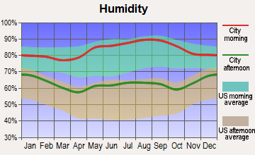
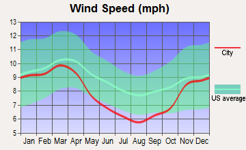
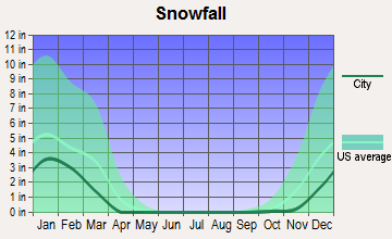
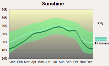
Average climate in Bruceton, Tennessee
Based on data reported by over 4,000 weather stations
|
|

(lower is better)
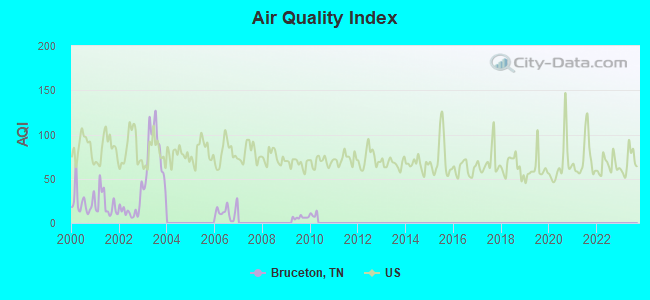
Air Quality Index (AQI) level in 2009 was 6.16. This is significantly better than average.
| City: | 6.16 |
| U.S.: | 72.56 |
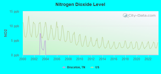
Nitrogen Dioxide (NO2) [ppb] level in 2003 was 3.86. This is better than average. Closest monitor was 8.0 miles away from the city center.
| City: | 3.86 |
| U.S.: | 5.11 |
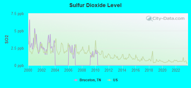
Sulfur Dioxide (SO2) [ppb] level in 2009 was 1.49. This is about average. Closest monitor was 8.0 miles away from the city center.
| City: | 1.49 |
| U.S.: | 1.51 |
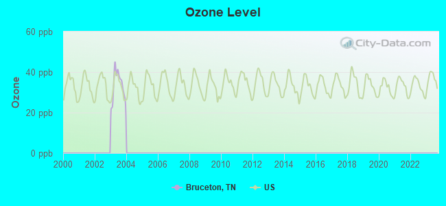
Ozone [ppb] level in 2003 was 33.2. This is about average. Closest monitor was 15.7 miles away from the city center.
| City: | 33.2 |
| U.S.: | 33.3 |
Tornado activity:
Bruceton-area historical tornado activity is slightly above Tennessee state average. It is 74% greater than the overall U.S. average.
On 5/7/1971, a category F4 (max. wind speeds 207-260 mph) tornado 22.2 miles away from the Bruceton town center killed 3 people and injured 137 people and caused between $500,000 and $5,000,000 in damages.
On 4/3/1956, a category F4 tornado 23.7 miles away from the town center killed 3 people and injured 60 people and caused between $500,000 and $5,000,000 in damages.
Earthquake activity:
Bruceton-area historical earthquake activity is significantly above Tennessee state average. It is 295% greater than the overall U.S. average.On 4/18/2008 at 09:36:59, a magnitude 5.4 (5.1 MB, 4.8 MS, 5.4 MW, 5.2 MW, Class: Moderate, Intensity: VI - VII) earthquake occurred 168.2 miles away from the city center
On 5/4/1991 at 01:18:54, a magnitude 5.0 (4.4 MB, 4.6 LG, 5.0 LG, Depth: 3.1 mi) earthquake occurred 95.2 miles away from the city center
On 9/26/1990 at 13:18:51, a magnitude 5.0 (4.7 MB, 4.8 LG, 5.0 LG, Depth: 7.7 mi) earthquake occurred 106.0 miles away from Bruceton center
On 3/25/1976 at 00:41:20, a magnitude 5.0 (4.9 MB, 5.0 LG) earthquake occurred 120.0 miles away from Bruceton center
On 4/18/2008 at 09:36:59, a magnitude 5.2 (5.2 MW, Depth: 8.9 mi) earthquake occurred 168.1 miles away from the city center
On 6/18/2002 at 17:37:15, a magnitude 5.0 (4.3 MB, 4.6 MW, 5.0 LG) earthquake occurred 137.3 miles away from Bruceton center
Magnitude types: regional Lg-wave magnitude (LG), body-wave magnitude (MB), surface-wave magnitude (MS), moment magnitude (MW)
Natural disasters:
The number of natural disasters in Carroll County (17) is near the US average (15).Major Disasters (Presidential) Declared: 14
Emergencies Declared: 1
Causes of natural disasters: Storms: 12, Floods: 10, Tornadoes: 10, Winds: 6, Winter Storms: 2, Flash Flood: 1, Hurricane: 1, Ice Storm: 1, Other: 1 (Note: some incidents may be assigned to more than one category).
Hospitals and medical centers in Bruceton:
Other hospitals and medical centers near Bruceton:
- CAMDEN GENERAL HOSPITAL Critical Access Hospitals (about 8 miles away; CAMDEN, TN)
- CAMDEN HLTHCARE AND REHAB CENTER (Nursing Home, about 8 miles away; CAMDEN, TN)
- HILLHAVEN CONVALESCENT CENTER CAMDEN (Nursing Home, about 8 miles away; CAMDEN, TN)
- TENNESSEE QUALITY HOMECARE NW (Home Health Center, about 8 miles away; CAMDEN, TN)
- HILLHAVEN CONV CTR HUNTINGDON (Nursing Home, about 10 miles away; HUNTINGDON, TN)
- HUNTINGDON HEALTH AND REHAB CENTER (Nursing Home, about 10 miles away; HUNTINGDON, TN)
- MCKENZIE HEALTH CARE CENTER (Nursing Home, about 16 miles away; MC KENZIE, TN)
Colleges/universities with over 2000 students nearest to Bruceton:
- Bethel University (about 17 miles; McKenzie, TN; Full-time enrollment: 5,878)
- Murray State University (about 41 miles; Murray, KY; FT enrollment: 8,930)
- The University of Tennessee-Martin (about 41 miles; Martin, TN; FT enrollment: 7,013)
- Jackson State Community College (about 41 miles; Jackson, TN; FT enrollment: 2,958)
- Union University (about 43 miles; Jackson, TN; FT enrollment: 4,051)
- Austin Peay State University (about 61 miles; Clarksville, TN; FT enrollment: 8,621)
- Dyersburg State Community College (about 65 miles; Dyersburg, TN; FT enrollment: 2,211)
Public elementary/middle school in Bruceton:
- CENTRAL ELEMENTARY (Students: 337, Location: 29590 BROAD ST, Grades: PK-5)
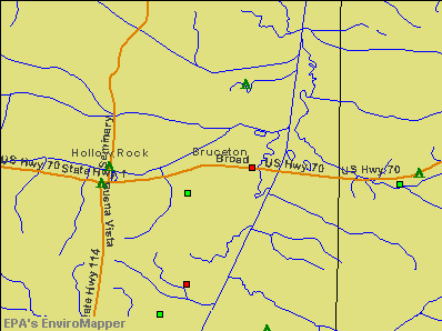
Points of interest:
Notable location: Bruceton Volunteer Fire Department (A). Display/hide its location on the map
Streams, rivers, and creeks: Brooks Branch (A). Display/hide its location on the map
Birthplace of: Patrick Willis - College football player.
Drinking water stations with addresses in Bruceton and their reported violations in the past:
ANN AND ANDY'S DAY CARE CENTER (Population served: 40, Groundwater):Past monitoring violations:
- One routine major monitoring violation
Drinking water stations with addresses in Bruceton that have no violations reported:
- BRUCETON WATER SYSTEM (Population served: 1,647, Primary Water Source Type: Groundwater)
| This town: | 2.4 people |
| Tennessee: | 2.5 people |
| This town: | 67.1% |
| Whole state: | 67.3% |
| This town: | 6.5% |
| Whole state: | 5.8% |
No gay or lesbian households reported
111 people in nursing homes in 2000
Banks with branches in Bruceton (2011 data):
- Bank of Camden: Bruceton Branch at 30703 Broad Street, branch established on 2009/04/15. Info updated 2009/11/06: Bank assets: $207.1 mil, Deposits: $154.1 mil, headquarters in Camden, TN, positive income, Commercial Lending Specialization, 8 total offices, Holding Company: Clayton Bancorp, Inc
For population 15 years and over in Bruceton:
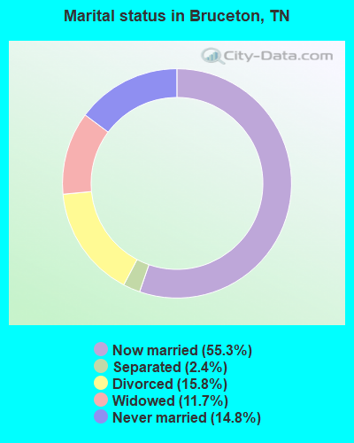
- Never married: 14.8%
- Now married: 55.3%
- Separated: 2.4%
- Widowed: 11.7%
- Divorced: 15.8%
For population 25 years and over in Bruceton:
- High school or higher: 88.8%
- Bachelor's degree or higher: 14.7%
- Graduate or professional degree: 2.4%
- Unemployed: 8.5%
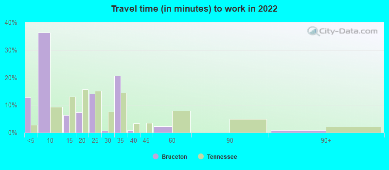
- Mean travel time to work (commute): 26.3 minutes
| Here: | 8.1 |
| Tennessee average: | 11.4 |
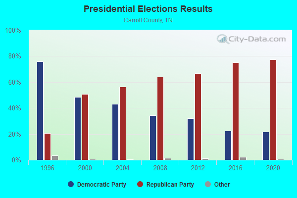
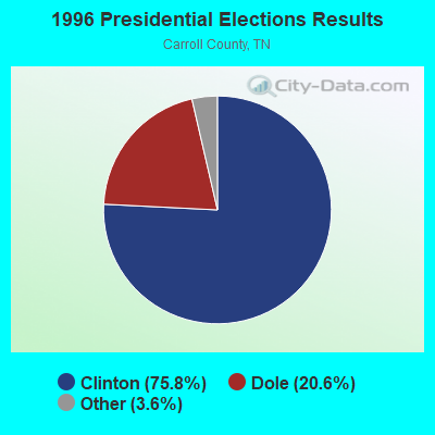
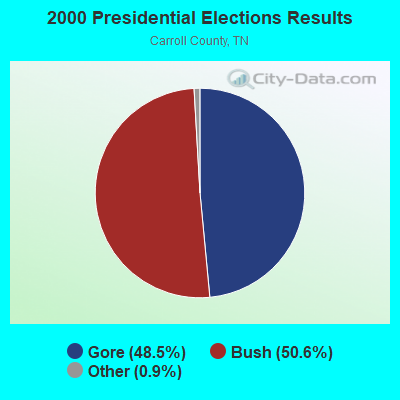
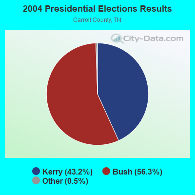
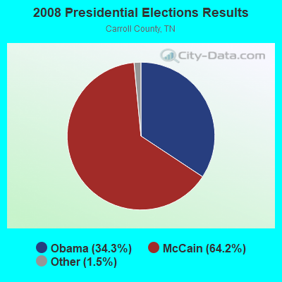
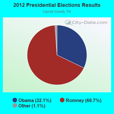
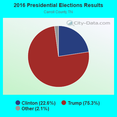
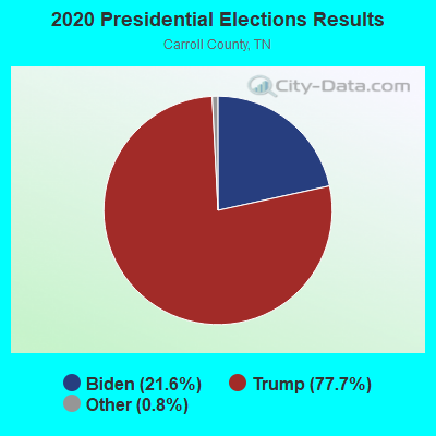
Graphs represent county-level data. Detailed 2008 Election Results
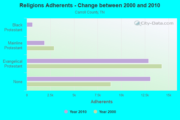
Religion statistics for Bruceton, TN (based on Carroll County data)
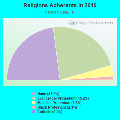
| Religion | Adherents | Congregations |
|---|---|---|
| Evangelical Protestant | 12,886 | 55 |
| Mainline Protestant | 1,883 | 21 |
| Black Protestant | 601 | 5 |
| Catholic | 69 | 1 |
| Other | 1 | - |
| None | 13,082 | - |
Food Environment Statistics:
| This county: | 2.77 / 10,000 pop. |
| Tennessee: | 1.99 / 10,000 pop. |
| This county: | 0.35 / 10,000 pop. |
| State: | 0.17 / 10,000 pop. |
| Here: | 6.59 / 10,000 pop. |
| State: | 5.16 / 10,000 pop. |
| Carroll County: | 6.59 / 10,000 pop. |
| State: | 6.56 / 10,000 pop. |
| Carroll County: | 11.9% |
| Tennessee: | 11.4% |
| Carroll County: | 29.0% |
| State: | 30.2% |
| Carroll County: | 11.7% |
| State: | 13.5% |
Health and Nutrition:
| This city: | 50.5% |
| Tennessee: | 49.3% |
| This city: | 47.4% |
| Tennessee: | 46.1% |
| This city: | 30.0 |
| Tennessee: | 28.8 |
| Bruceton: | 21.8% |
| Tennessee: | 21.0% |
| Bruceton: | 21.5% |
| State: | 10.5% |
| Bruceton: | 6.9 |
| Tennessee: | 6.8 |
| This city: | 42.7% |
| Tennessee: | 33.9% |
| Here: | 53.2% |
| Tennessee: | 55.9% |
| This city: | 76.4% |
| Tennessee: | 79.1% |
More about Health and Nutrition of Bruceton, TN Residents
| Local government employment and payroll (March 2022) | |||||
| Function | Full-time employees | Monthly full-time payroll | Average yearly full-time wage | Part-time employees | Monthly part-time payroll |
|---|---|---|---|---|---|
| Police Protection - Officers | 5 | $17,745 | $42,588 | 0 | $0 |
| Other Government Administration | 2 | $6,568 | $39,408 | 0 | $0 |
| Parks and Recreation | 2 | $6,656 | $39,936 | 0 | $0 |
| Sewerage | 1 | $3,184 | $38,208 | 0 | $0 |
| Water Supply | 1 | $2,095 | $25,140 | 0 | $0 |
| Police - Other | 0 | $0 | 1 | $1,625 | |
| Totals for Government | 11 | $36,248 | $39,543 | 1 | $1,625 |
Bruceton government finances - Expenditure in 2017 (per resident):
- Current Operations - Central Staff Services: $419,000 ($279.71)
Police Protection: $245,000 ($163.55)
Regular Highways: $168,000 ($112.15)
Water Utilities: $162,000 ($108.14)
Solid Waste Management: $157,000 ($104.81)
Sewerage: $155,000 ($103.47)
Local Fire Protection: $29,000 ($19.36)
Parks and Recreation: $16,000 ($10.68)
General - Other: $6,000 ($4.01)
- Other Capital Outlay - Local Fire Protection: $6,000 ($4.01)
Water Utilities: $5,000 ($3.34)
Police Protection: $4,000 ($2.67)
Financial Administration: $1,000 ($0.67)
- Total Salaries and Wages: $368,000 ($245.66)
- Water Utilities - Interest on Debt: $24,000 ($16.02)
Bruceton government finances - Revenue in 2017 (per resident):
- Charges - Sewerage: $202,000 ($134.85)
Solid Waste Management: $155,000 ($103.47)
Other: $22,000 ($14.69)
- Local Intergovernmental - General Local Government Support: $53,000 ($35.38)
- Miscellaneous - General Revenue - Other: $248,000 ($165.55)
Fines and Forfeits: $14,000 ($9.35)
Interest Earnings: $5,000 ($3.34)
- Revenue - Water Utilities: $227,000 ($151.54)
- State Intergovernmental - General Local Government Support: $150,000 ($100.13)
Highways: $40,000 ($26.70)
- Tax - Property: $450,000 ($300.40)
Alcoholic Beverage Sales: $80,000 ($53.40)
Other License: $19,000 ($12.68)
Occupation and Business License - Other: $9,000 ($6.01)
Bruceton government finances - Debt in 2017 (per resident):
- Long Term Debt - Beginning Outstanding - Unspecified Public Purpose: $556,000 ($371.16)
Outstanding Unspecified Public Purpose: $450,000 ($300.40)
Retired Unspecified Public Purpose: $106,000 ($70.76)
Bruceton government finances - Cash and Securities in 2017 (per resident):
- Other Funds - Cash and Securities: $517,000 ($345.13)
- Sinking Funds - Cash and Securities: $380,000 ($253.67)
Strongest AM radio stations in Bruceton:
- WMUF (1000 AM; daytime; 5 kW; PARIS, TN; Owner: BENTON-WEATHERFORD B/CTING OF TN,INC)
- WSM (650 AM; 50 kW; NASHVILLE, TN; Owner: GAYLORD ENTERTAINMENT COMPANY)
- WKDA (1200 AM; 50 kW; NASHVILLE, TN; Owner: RADIO NASHVILLE, INC.)
- WNQM (1300 AM; 50 kW; NASHVILLE, TN; Owner: WNQM. INC.)
- WAMB (1160 AM; 50 kW; DONELSON, TN; Owner: GREAT SOUTHERN BROADCASTING COMPANY, INC.)
- WDAP (1530 AM; daytime; 1 kW; HUNTINGDON, TN; Owner: MARK C. JOHNSON)
- WCRV (640 AM; 50 kW; COLLIERVILLE, TN; Owner: BOTT BROADCASTING COMPANY/TENNESSEE)
- WLAC (1510 AM; 50 kW; NASHVILLE, TN; Owner: CAPSTAR TX LIMITED PARTNERSHIP)
- WGSF (1030 AM; 50 kW; MEMPHIS, TN; Owner: FLINN BROADCASTING CORPORATION)
- WDIA (1070 AM; 50 kW; MEMPHIS, TN; Owner: CLEAR CHANNEL BROADCASTING LICENSES, INC.)
- WTPR (710 AM; daytime; 1 kW; PARIS, TN; Owner: WENK BROADCAST GROUP, INC.)
- WMQM (1600 AM; 50 kW; LAKELAND, TN; Owner: WMQM, INC.)
- WFWL (1220 AM; 0 kW; CAMDEN, TN; Owner: COMMUNITY BROADCASTING SERVICES, INC)
Strongest FM radio stations in Bruceton:
- WMUF-FM (104.7 FM; HENRY, TN; Owner: BENTON WEATHERFORD B/C INC OF TN)
- WRJB (95.9 FM; CAMDEN, TN; Owner: COMMUNITY BROADCASTING SERVICES, INC)
- WYNU (92.3 FM; MILAN, TN; Owner: CAPSTAR TX LIMITED PARTNERSHIP)
- WVHR (100.9 FM; HUNTINGDON, TN; Owner: MILAN BROADCASTING COMPANY, INC.)
- WAKQ (105.5 FM; PARIS, TN; Owner: WENK BROADCAST GROUP, INC.)
- WWYN (106.9 FM; MCKENZIE, TN; Owner: RAINBOW MEDIA, INC.)
- WFGZ (94.5 FM; LOBELVILLE, TN; Owner: OHIO BROADCAST ASSOCIATES)
- WAJJ (89.3 FM; MCKENZIE, TN; Owner: HEARTLAND MINSTRIES, INC.)
- WAYW (89.9 FM; NEW JOHNSONVILLE, TN; Owner: WAY-FM MEDIA GROUP, INC.)
- WTPR-FM (101.5 FM; MCKINNON, TN; Owner: WENK BROADCAST GROUP)
- WLZK (94.1 FM; PARIS, TN; Owner: BENTON-WEATHERFORD BRD/CST INC OF TN)
- WTKB-FM (93.7 FM; ATWOOD, TN; Owner: GIBSON COUNTY BROADCASTING COMPANY, INC.)
- WIGH (88.7 FM; LEXINGTON, TN; Owner: AMERICAN FAMILY ASSOCIATION)
- WBFG (96.5 FM; PARKER'S CROSSROADS, TN; Owner: CROSSROADS BROADCASTING, LLC)
- WFGE (103.7 FM; MURRAY, KY; Owner: FOREVER COMMUNICATIONS INC)
TV broadcast stations around Bruceton:
- WBBJ-TV (Channel 7; JACKSON, TN; Owner: TENNESSEE BROADCASTING PARTNERS)
- W26CJ (Channel 26; JACKSON, TN; Owner: MS COMMUNICATIONS, LLC)
- WJTE-LP (Channel 19; JACKSON, TN; Owner: TIGER EYE BROADCASTING CORPORATION)
- W22BR (Channel 22; JACKSON, TN; Owner: MS COMMUNICATIONS, LLC)
- W52CZ (Channel 52; JACKSON, TN; Owner: MS COMMUNICATIONS, LLC)
- W64BZ (Channel 64; JACKSON, TN; Owner: MS COMMUNICATIONS, LLC)
Bruceton fatal accident list:
Mar 18, 2008 09:35 PM, S Carroll St, Lat: 36.037970, Lon: -88.242940, Vehicles: 1, Persons: 1, Fatalities: 1, Drunk persons involved: 1
Apr 9, 2001 06:26 AM, Us-Sr1, Vehicles: 2, Persons: 3, Fatalities: 1
Dec 19, 1994 04:11 PM, Sr1, Vehicles: 1, Persons: 2, Pedestrians: 1, Fatalities: 1
Aug 24, 1987 04:27 AM, Vehicles: 1, Persons: 2, Fatalities: 1
Apr 8, 1976 10:52 AM, Vehicles: 2, Persons: 3, Fatalities: 1
Apr 8, 1975 10:52 AM, Vehicles: 2, Persons: 3, Fatalities: 1
- National Bridge Inventory (NBI) Statistics
- 18Number of bridges
- 157ft / 48.3mTotal length
- $7,083,000Total costs
- 35,165Total average daily traffic
- 2,328Total average daily truck traffic
- 58,214Total future (year 2039) average daily traffic
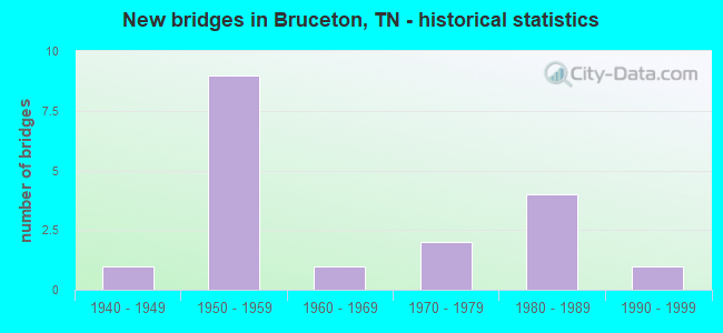
- New bridges - historical statistics
- 11940-1949
- 91950-1959
- 11960-1969
- 21970-1979
- 41980-1989
- 11990-1999
FCC Registered Antenna Towers:
21 (See the full list of FCC Registered Antenna Towers in Bruceton)FCC Registered Broadcast Land Mobile Towers:
2- L6, Lat: 36.034833 Lon: -88.191500, Call Sign: WQKZ212,
Assigned Frequencies: 160.785 MHz, Grant Date: 11/02/2009, Expiration Date: 11/02/2019, Cancellation Date: 01/04/2020, Certifier: Shantrice Cruse, Registrant: Csx Transportation, 6735 Southpoint Dr South, 4th Flr J958, Jacksonville, FL 32216, Phone: (904) 332-5925, Fax: (904) 332-6048, Email:
- L1, Lat: 36.036083 Lon: -88.259611, Call Sign: WRAM518,
Assigned Frequencies: 160.590 MHz, Grant Date: 01/08/2018, Expiration Date: 01/08/2028, Certifier: Shantrice Cruse-Scott, Registrant: Csx Transportation Inc, 6735 Southpoint Dr S, 4th Flr J958, Jacksonville, FL 32216, Phone: (904) 332-5925, Fax: (904) 332-6013, Email:
FCC Registered Microwave Towers:
2- JK435 Bruceton, 1040 Rowland Mills Rd (Lat: 36.021750 Lon: -88.255417), Type: Tower, Structure height: 79.2 m, Call Sign: WQOC416,
Assigned Frequencies: 11015.0 MHz, Grant Date: 08/10/2011, Expiration Date: 08/10/2021, Cancellation Date: 10/16/2021, Certifier: Mike Jaksich, Registrant: Lukas, Lafuria, Gutierrez & Sachs, LLP, 8300 Greensboro Drive, Suite 1200, Tysons, VA 22102, Phone: (703) 584-8678, Email:
- 9ME2132A, 1040 Rowland Mills Rd (Lat: 36.021750 Lon: -88.255417), Type: Ltower, Structure height: 79.2 m, Call Sign: WQXQ830,
Assigned Frequencies: 10835.0 MHz, 10915.0 MHz, 10835.0 MHz, 10915.0 MHz, 10835.0 MHz, 10915.0 MHz, 10835.0 MHz, 10915.0 MHz, 10835.0 MHz, 10915.0 MHz... (+12 more), Grant Date: 05/12/2016, Expiration Date: 05/12/2026, Certifier: David Werblow, Registrant: T-Mobile License LLC, 12920 Se 38th St, Bellevue, WA 98006, Phone: (425) 383-8401, Fax: (425) 383-4040, Email:
FCC Registered Paging Towers:
1- 1.4 Km Sw Of (Lat: 36.028389 Lon: -88.255028), Overall height: 4 m, Call Sign: KNKP775,
Assigned Frequencies: 931.612 MHz, Grant Date: 04/19/1999, Expiration Date: 04/01/2009, Cancellation Date: 11/12/2004, Registrant: Greenberg Traurig, 1300 Connecticut Avenue, Nw, Suite 1000, Washington, DC 20036, Phone: (202) 331-3161, Fax: (202) 331-3101, Email:
FCC Registered Amateur Radio Licenses:
21 (See the full list of FCC Registered Amateur Radio Licenses in Bruceton)FAA Registered Aircraft:
1- Aircraft: LUTHER LINDELL RAY TEAM INC MINI MAX (Category: Land, Weight: Up to 12,499 Pounds), Engine: BOMBARDIER ROTAX (ALL) (Reciprocating)
N-Number: 176RL, N176RL, N-176RL, Serial Number: 176, Year manufactured: 1990, Airworthiness Date: 03/20/1990, Certificate Issue Date: 02/27/1989
Registrant (Individual): Lindell R Luther, 117 Enterprize St, Bruceton, TN 38317
2004 - 2018 National Fire Incident Reporting System (NFIRS) incidents
- Fire incident types reported to NFIRS in Bruceton, TN
- 7847.3%Structure Fires
- 6137.0%Outside Fires
- 1810.9%Mobile Property/Vehicle Fires
- 84.8%Other
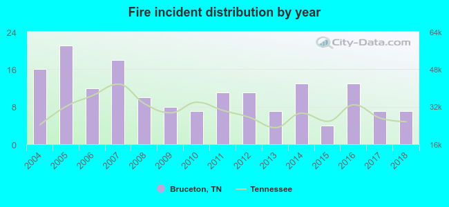 Based on the data from the years 2004 - 2018 the average number of fires per year is 11. The highest number of fire incidents - 21 took place in 2005, and the least - 4 in 2015. The data has a dropping trend.
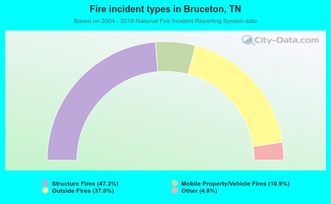 When looking into fire subcategories, the most incidents belonged to: Structure Fires (47.3%), and Outside Fires (37.0%).
| Most common first names in Bruceton, TN among deceased individuals | ||
| Name | Count | Lived (average) |
|---|---|---|
| William | 43 | 71.3 years |
| James | 35 | 71.7 years |
| John | 26 | 68.9 years |
| Mary | 25 | 79.8 years |
| Thomas | 19 | 73.9 years |
| Robert | 14 | 74.9 years |
| Willie | 11 | 71.4 years |
| Ruth | 10 | 82.7 years |
| Lillie | 10 | 78.9 years |
| Edna | 9 | 73.5 years |
| Most common last names in Bruceton, TN among deceased individuals | ||
| Last name | Count | Lived (average) |
|---|---|---|
| Williams | 26 | 76.7 years |
| Jordan | 21 | 76.1 years |
| Lowe | 16 | 68.9 years |
| Cole | 14 | 73.5 years |
| Allen | 13 | 74.9 years |
| Park | 13 | 76.4 years |
| Smith | 13 | 78.2 years |
| Rogers | 13 | 73.7 years |
| Wilson | 11 | 79.7 years |
| Moore | 11 | 75.2 years |
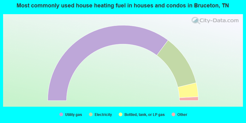
- 70.7%Utility gas
- 22.1%Electricity
- 6.0%Bottled, tank, or LP gas
- 0.8%Wood
- 0.5%Fuel oil, kerosene, etc.
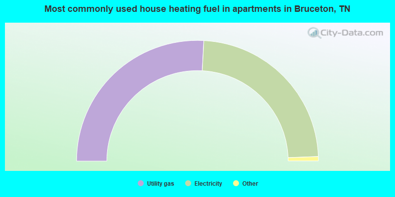
- 52.3%Utility gas
- 47.7%Electricity
Bruceton compared to Tennessee state average:
- Median house value significantly below state average.
- Black race population percentage significantly below state average.
- Hispanic race population percentage significantly below state average.
- Foreign-born population percentage significantly below state average.
- Length of stay since moving in significantly above state average.
- House age above state average.
- Institutionalized population percentage significantly above state average.
- Number of college students below state average.