Deerwood, Minnesota
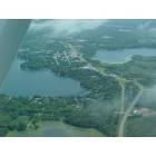
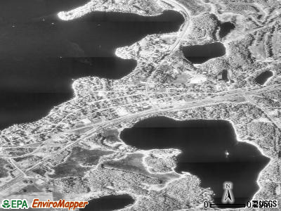
Deerwood: Taken from approximately 2000 feet on Aug. 11, 2007
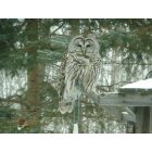
Deerwood: Barred Owl on our bird feeder
- add
your
Submit your own pictures of this city and show them to the world
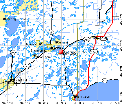
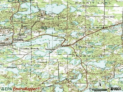
- OSM Map
- General Map
- Google Map
- MSN Map
Population change since 2000: -1.4%
 |
| Males: 248 | |
| Females: 334 |
| Median resident age: | 32.6 years |
| Minnesota median age: | 39.0 years |
Zip codes: 56444.
| Deerwood: | $53,224 |
| MN: | $82,338 |
Estimated per capita income in 2022: $27,824 (it was $15,697 in 2000)
Deerwood city income, earnings, and wages data
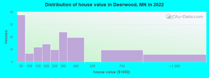
Estimated median house or condo value in 2022: $240,037 (it was $87,700 in 2000)
| Deerwood: | $240,037 |
| MN: | $314,600 |
Mean prices in 2022: all housing units: $211,390; detached houses: $259,378; townhouses or other attached units: $446,461; mobile homes: $21,429
Median gross rent in 2022: $509.
(10.3% for White Non-Hispanic residents, 34.0% for two or more races residents)
Detailed information about poverty and poor residents in Deerwood, MN

Compare current foreclosures near Deerwood, MN:
| Photo | Address | Area | Beds / Baths | Price | Details |
|---|---|---|---|---|---|

|
#1
County Road 10
Deerwood, MN 56444
|
- sq. feet
|
- baths - beds |
show details | |

|
#2
Wise Rd
Brainerd, MN 56401
|
1,127 sq. feet
|
2 baths 3 beds |
$274,900
|
show details |

|
#3
Fir St
Brainerd, MN 56401
|
986 sq. feet
|
1 baths 3 beds |
$64,900
|
show details |

|
#4
Maghan Rd
Deerwood, MN 56444
|
- sq. feet
|
- baths - beds |
show details | |

|
#5
County Road 10
Deerwood, MN 56444
|
- sq. feet
|
- baths - beds |
show details | |

|
#6
513 Street NE
Brainerd, MN 56401
|
1,469 sq. feet
|
2 baths 4 beds |
show details | |

|
#7
H St NE
Brainerd, MN 56401
|
1,120 sq. feet
|
- baths 2 beds |
show details | |

|
#8
Lake Rd
Ironton, MN 56455
|
- sq. feet
|
1 baths 2 beds |
show details | |

|
#9
Madison St
Brainerd, MN 56401
|
- sq. feet
|
- baths - beds |
show details | |

|
#10
6th St NE
Crosby, MN 56441
|
- sq. feet
|
- baths - beds |
show details |
| Photo | Address | Area | Beds / Baths | Price | Details |
|---|---|---|---|---|---|

|
#11
Quast Ave
Brainerd, MN 56401
|
- sq. feet
|
- baths - beds |
show details | |

|
#12
Ebinger Rd
Brainerd, MN 56401
|
- sq. feet
|
- baths - beds |
show details | |

|
#13
Bluff Ave
Brainerd, MN 56401
|
- sq. feet
|
- baths - beds |
show details | |

|
#14
Yellow Brick Rd
Brainerd, MN 56401
|
- sq. feet
|
- baths - beds |
show details | |

|
#15
14th Ave NE
Brainerd, MN 56401
|
- sq. feet
|
- baths - beds |
show details | |

|
#16
Laurel St
Brainerd, MN 56401
|
- sq. feet
|
- baths - beds |
show details | |

|
#17
O St NE
Brainerd, MN 56401
|
- sq. feet
|
- baths - beds |
show details | |

|
#18
W Laurel St Apt 2
Brainerd, MN 56401
|
- sq. feet
|
- baths - beds |
show details | |

|
#19
E Lake Hubert Dr
Nisswa, MN 56468
|
- sq. feet
|
- baths - beds |
show details | |

|
#20
Fir St
Brainerd, MN 56401
|
- sq. feet
|
- baths - beds |
show details |
| Photo | Address | Area | Beds / Baths | Price | Details |
|---|---|---|---|---|---|

|
#21
Shafer Rd
Crosslake, MN 56442
|
- sq. feet
|
- baths - beds |
show details | |

|
#22
1st Ave NE
Brainerd, MN 56401
|
- sq. feet
|
- baths - beds |
show details | |

|
#23
E St NE
Brainerd, MN 56401
|
- sq. feet
|
- baths - beds |
show details | |

|
#24
28th St SE
Brainerd, MN 56401
|
- sq. feet
|
- baths - beds |
show details | |

|
#25
Wolves St
Brainerd, MN 56401
|
- sq. feet
|
- baths - beds |
show details | |

|
#26
State Highway 18
Aitkin, MN 56431
|
- sq. feet
|
- baths - beds |
show details | |

|
#27
Greenwood Rd Apt 2e
Baxter, MN 56425
|
- sq. feet
|
- baths - beds |
show details | |

|
#28
County Road 19
Merrifield, MN 56465
|
- sq. feet
|
- baths - beds |
show details | |

|
#29
328th Ln
Aitkin, MN 56431
|
2,876 sq. feet
|
- baths - beds |
show details | |

|
#30
Minnesota Ave S
Aitkin, MN 56431
|
- sq. feet
|
- baths - beds |
show details |
| Photo | Address | Area | Beds / Baths | Price | Details |
|---|---|---|---|---|---|

|
#31
Delivery
Brainerd, MN 56401
|
- sq. feet
|
- baths - beds |
show details | |

|
#32
4th St NW
Aitkin, MN 56431
|
1,395 sq. feet
|
- baths - beds |
show details | |

|
#33
335th Ln
Aitkin, MN 56431
|
2,652 sq. feet
|
- baths - beds |
show details | |

|
#34
1st Ave SW
Aitkin, MN 56431
|
1,909 sq. feet
|
- baths - beds |
show details | |

|
#35
4th Ave NW
Aitkin, MN 56431
|
1,586 sq. feet
|
- baths - beds |
show details | |

|
#36
340th Ln
Aitkin, MN 56431
|
2,720 sq. feet
|
- baths - beds |
show details | |

|
#37
E Lake Hubert Dr
Brainerd, MN 56401
|
- sq. feet
|
- baths - beds |
show details | |

|
#38
Deer Run Rd
Brainerd, MN 56401
|
- sq. feet
|
- baths - beds |
show details | |

|
#39
454th Ave
Aitkin, MN 56431
|
- sq. feet
|
- baths - beds |
show details | |

|
#40
Jessica Ln
Brainerd, MN 56401
|
- sq. feet
|
- baths - beds |
show details |
| Photo | Address | Area | Beds / Baths | Price | Details |
|---|---|---|---|---|---|

|
#41
430th Ave
Aitkin, MN 56431
|
5,234 sq. feet
|
- baths - beds |
show details | |

|
#42
Quince St
Brainerd, MN 56401
|
- sq. feet
|
- baths - beds |
show details | |

|
#43
Oak St
Brainerd, MN 56401
|
- sq. feet
|
- baths - beds |
show details | |

|
#44
Oak St
Brainerd, MN 56401
|
- sq. feet
|
- baths - beds |
show details | |

|
#45
Norwood St # 1
Brainerd, MN 56401
|
- sq. feet
|
- baths - beds |
show details | |

|
#46
Paradise Beach Rd
Brainerd, MN 56401
|
- sq. feet
|
- baths - beds |
show details | |

|
#47
N 3rd St
Brainerd, MN 56401
|
- sq. feet
|
- baths - beds |
show details | |

|
#48
N 9th St
Brainerd, MN 56401
|
- sq. feet
|
- baths - beds |
show details | |

|
#49
Golden Pond Dr
Brainerd, MN 56401
|
- sq. feet
|
- baths - beds |
show details | |

|
Check over 1 million property listings on Foreclosure.com!
|
browse all offers | |||


- 57188.8%White alone
- 6410.0%Two or more races
- 152.3%Hispanic
- 10.2%American Indian alone
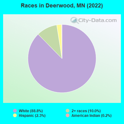
Races in Deerwood detailed stats: ancestries, foreign born residents, place of birth
Type |
2020 |
2021 |
2022 |
|---|---|---|---|
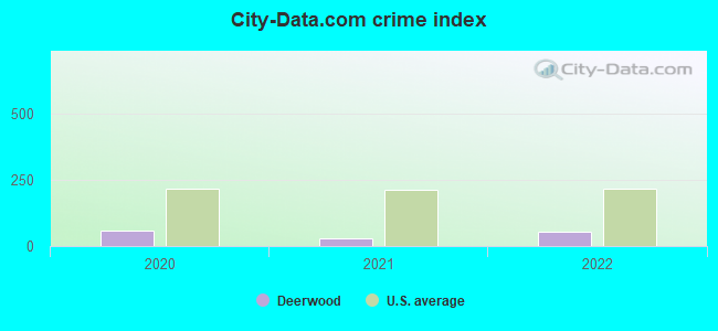
| Murders (per 100,000) | 0 (0.0) | 0 (0.0) | 0 (0.0) |
| Rapes (per 100,000) | 0 (0.0) | 0 (0.0) | 0 (0.0) |
| Robberies (per 100,000) | 0 (0.0) | 0 (0.0) | 0 (0.0) |
| Assaults (per 100,000) | 1 (188.0) | 0 (0.0) | 1 (167.2) |
| Burglaries (per 100,000) | 0 (0.0) | 1 (133.0) | 0 (0.0) |
| Thefts (per 100,000) | 3 (563.9) | 4 (531.9) | 1 (167.2) |
| Auto thefts (per 100,000) | 0 (0.0) | 0 (0.0) | 1 (167.2) |
| Arson (per 100,000) | 0 (0.0) | 0 (0.0) | 0 (0.0) |
| City-Data.com crime index | 60.2 | 30.6 | 53.5 |
The City-Data.com crime index weighs serious crimes and violent crimes more heavily. Higher means more crime, U.S. average is 246.1. It adjusts for the number of visitors and daily workers commuting into cities.
Crime rate in Deerwood detailed stats: murders, rapes, robberies, assaults, burglaries, thefts, arson
Full-time law enforcement employees in 2021, including police officers: 3 (3 officers - 3 male; 0 female).
| Officers per 1,000 residents here: | 3.99 |
| Minnesota average: | 1.76 |
 Recent articles from our blog. Our writers, many of them Ph.D. graduates or candidates, create easy-to-read articles on a wide variety of topics.

 | South Minneapolis Schools (32 replies) |
| Is there a MN town just like this one in WI? (15 replies) |
| California to Minneapolis with kids and crazy job lined up (29 replies) |
| Suggestions (12 replies) |
Latest news from Deerwood, MN collected exclusively by city-data.com from local newspapers, TV, and radio stations
Ancestries: German (22.4%), English (21.8%), Irish (16.4%), Norwegian (13.3%), Dutch (6.7%), European (2.4%).
Current Local Time: CST time zone
Land area: 1.37 square miles.
Population density: 425 people per square mile (low).
4 residents are foreign born
| This city: | 0.7% |
| Minnesota: | 5.3% |
| Deerwood city: | 0.6% ($527) |
| Minnesota: | 1.1% ($1,297) |
Nearest city with pop. 50,000+: St. Cloud, MN  (64.7 miles , pop. 59,107).
Nearest city with pop. 200,000+: Minneapolis, MN (108.8 miles , pop. 382,618).
Nearest city with pop. 1,000,000+: Chicago, IL (444.7 miles , pop. 2,896,016).
Nearest cities:
), Latitude: 46.47 N, Longitude: 93.90 W
Area code: 218
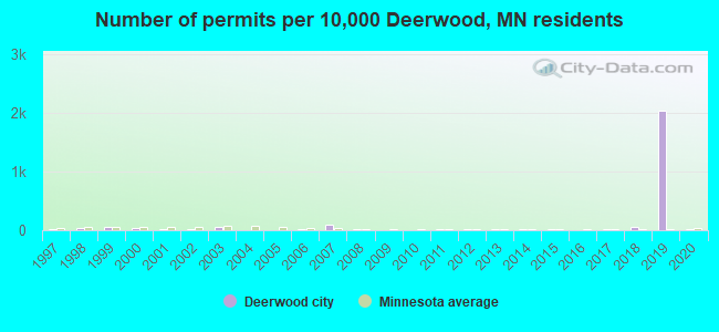
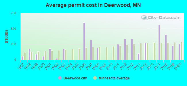
Single-family new house construction building permits:
- 2020: 1 building, cost: $260,000
- 2019: 120 buildings, average cost: $226,000
- 2018: 3 buildings, average cost: $406,300
- 2017: 1 building, cost: $560,000
- 2015: 1 building, cost: $275,000
- 2014: 1 building, cost: $100,000
- 2013: 1 building, cost: $338,000
- 2012: 1 building, cost: $338,000
- 2011: 1 building, cost: $250,000
- 2008: 1 building, cost: $190,000
- 2007: 5 buildings, average cost: $321,400
- 2006: 1 building, cost: $600,000
- 2003: 3 buildings, average cost: $176,500
- 2002: 1 building, cost: $22,000
- 2001: 1 building, cost: $180,000
- 2000: 2 buildings, average cost: $55,000
- 1999: 3 buildings, average cost: $88,200
- 1998: 2 buildings, average cost: $174,500
- 1997: 1 building, cost: $55,000
| Here: | 3.9% |
| Minnesota: | 2.6% |
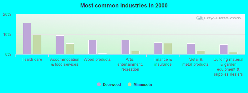
- Health care (15.8%)
- Accommodation & food services (9.5%)
- Wood products (7.2%)
- Arts, entertainment, recreation (7.2%)
- Finance & insurance (5.9%)
- Metal & metal products (5.4%)
- Building material & garden equipment & supplies dealers (5.0%)
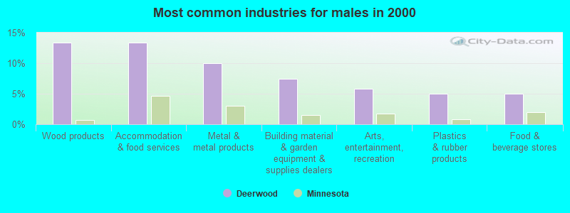
- Wood products (13.3%)
- Accommodation & food services (13.3%)
- Metal & metal products (10.0%)
- Building material & garden equipment & supplies dealers (7.5%)
- Arts, entertainment, recreation (5.8%)
- Plastics & rubber products (5.0%)
- Food & beverage stores (5.0%)
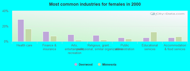
- Health care (28.7%)
- Finance & insurance (12.9%)
- Arts, entertainment, recreation (8.9%)
- Religious, grantmaking, civic, professional, similar organizations (7.9%)
- Public administration (5.0%)
- Educational services (5.0%)
- Accommodation & food services (5.0%)
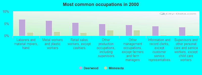
- Laborers and material movers, hand (6.8%)
- Metal workers and plastic workers (6.3%)
- Retail sales workers, except cashiers (5.4%)
- Other production occupations, including supervisors (5.0%)
- Other management occupations, except farmers and farm managers (4.5%)
- Information and record clerks, except customer service representatives (4.1%)
- Supervisors and other personal care and service workers, except child care workers (3.6%)
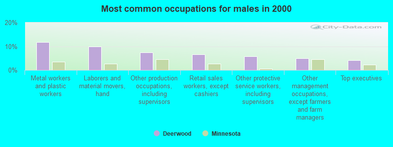
- Metal workers and plastic workers (11.7%)
- Laborers and material movers, hand (10.0%)
- Other production occupations, including supervisors (7.5%)
- Retail sales workers, except cashiers (6.7%)
- Other protective service workers, including supervisors (5.8%)
- Other management occupations, except farmers and farm managers (5.0%)
- Top executives (4.2%)
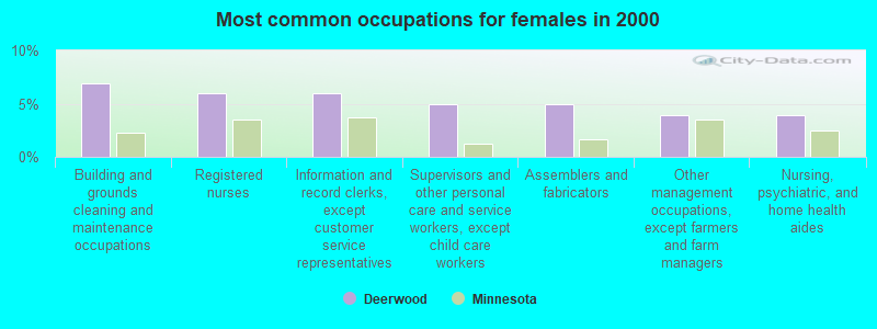
- Building and grounds cleaning and maintenance occupations (6.9%)
- Registered nurses (5.9%)
- Information and record clerks, except customer service representatives (5.9%)
- Supervisors and other personal care and service workers, except child care workers (5.0%)
- Assemblers and fabricators (5.0%)
- Other management occupations, except farmers and farm managers (4.0%)
- Nursing, psychiatric, and home health aides (4.0%)
Average climate in Deerwood, Minnesota
Based on data reported by over 4,000 weather stations


(lower is better)
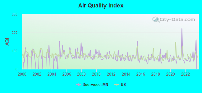
Air Quality Index (AQI) level in 2022 was 53.0. This is better than average.
| City: | 53.0 |
| U.S.: | 72.6 |
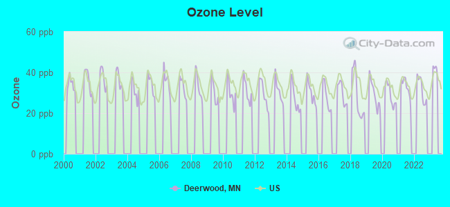
Ozone [ppb] level in 2022 was 31.6. This is about average. Closest monitor was 12.1 miles away from the city center.
| City: | 31.6 |
| U.S.: | 33.3 |
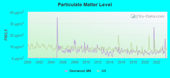
Particulate Matter (PM2.5) [µg/m3] level in 2022 was 5.71. This is significantly better than average. Closest monitor was 12.1 miles away from the city center.
| City: | 5.71 |
| U.S.: | 8.11 |
Tornado activity:
Deerwood-area historical tornado activity is below Minnesota state average. It is 42% smaller than the overall U.S. average.
On 6/11/1966, a category F4 (max. wind speeds 207-260 mph) tornado 24.7 miles away from the Deerwood city center caused between $50,000 and $500,000 in damages.
On 8/6/1969, a category F4 tornado 26.0 miles away from the city center killed 12 people and injured 70 people and caused between $500,000 and $5,000,000 in damages.
Earthquake activity:
Deerwood-area historical earthquake activity is significantly above Minnesota state average. It is 51% smaller than the overall U.S. average.On 7/9/1975 at 14:54:15, a magnitude 4.6 (4.6 MB, Class: Light, Intensity: IV - V) earthquake occurred 116.8 miles away from the city center
On 6/5/1993 at 01:24:53, a magnitude 4.1 (4.1 LG, Depth: 6.2 mi) earthquake occurred 127.4 miles away from the city center
On 3/4/1983 at 06:32:18, a magnitude 4.6 (4.4 MB, 4.6 LG, 4.4 ML) earthquake occurred 309.9 miles away from the city center
On 10/20/1995 at 15:57:18, a magnitude 3.7 (3.7 LG, Depth: 3.1 mi, Class: Light, Intensity: II - III) earthquake occurred 149.7 miles away from the city center
On 2/7/2020 at 18:30:28, a magnitude 3.3 (3.3 ML) earthquake occurred 88.9 miles away from the city center
On 1/9/2020 at 18:16:48, a magnitude 3.3 (3.3 MB) earthquake occurred 94.0 miles away from the city center
Magnitude types: regional Lg-wave magnitude (LG), body-wave magnitude (MB), local magnitude (ML)
Natural disasters:
The number of natural disasters in Crow Wing County (11) is smaller than the US average (15).Major Disasters (Presidential) Declared: 7
Emergencies Declared: 2
Causes of natural disasters: Floods: 7, Storms: 3, Drought: 1, Fire: 1, Hurricane: 1, Tornado: 1, Wind: 1, Other: 1 (Note: some incidents may be assigned to more than one category).
Hospitals and medical centers near Deerwood:
- HOMEHEALTH PARTNERSHIP (Home Health Center, about 3 miles away; CROSBY, MN)
- CUYUNA REGIONAL MEDICAL CENTER (Nursing Home, about 3 miles away; CROSBY, MN)
- WOODHAVEN SENIOR COMM (Nursing Home, about 10 miles away; BRAINERD, MN)
- RIVERWOOD HEALTH CARE CENTER (Hospital, about 10 miles away; AITKIN, MN)
- AITKIN HEALTH SERVICES (Nursing Home, about 10 miles away; AITKIN, MN)
- BARNABAS HEALTH CARE SERV (Home Health Center, about 16 miles away; BRAINERD, MN)
- MINNESOTA NEUROREHABILITATION HOSPITAL (Hospital, about 16 miles away; BRAINERD, MN)
Airports and other landing facilities located in Deerwood:
- Lindey's Landing Airport (5MN7) (Runways: 3)
- Sethney Personal Airport (8MN4) (Runways: 1)
- Birch Lake Seaplane Base (M69)
- Shirt Lake Seaplane Base (25MN)
Colleges/universities with over 2000 students nearest to Deerwood:
- Central Lakes College-Brainerd (about 18 miles; Brainerd, MN; Full-time enrollment: 3,371)
- St Cloud Technical and Community College (about 64 miles; Saint Cloud, MN; FT enrollment: 3,493)
- Saint Cloud State University (about 65 miles; Saint Cloud, MN; FT enrollment: 12,822)
- Rasmussen College-Minnesota (about 66 miles; St. Cloud, MN; FT enrollment: 4,575)
- College of Saint Benedict (about 67 miles; Saint Joseph, MN; FT enrollment: 2,025)
- Alexandria Technical & Community College (about 82 miles; Alexandria, MN; FT enrollment: 2,324)
- Bemidji State University (about 84 miles; Bemidji, MN; FT enrollment: 4,316)
Points of interest:
Notable locations in Deerwood: Deerwood (A), Heartland Sports Complex (B), Cuyuna Country Club (C), Deerwood City Hall (D), Deerwood Police Department (E), Deerwood Volunteer Fire Department (F). Display/hide their locations on the map
Churches in Deerwood include: Lighthouse Community Church (A), Salem Lutheran Church (B), Deerwood Baptist Church (C), Saint Joseph Church (D). Display/hide their locations on the map
Lake: Reno Lake (A). Display/hide its location on the map
Hotels: Country Inns & Suites by Carlson - Country Inn by Carlson-Deerwood (115 Front Street East), Country Inn - Deerwood (23884 Front Street PO Box 250).
Drinking water stations with addresses in Deerwood that have no violations reported:
- DEERWOOD (Population served: 534, Primary Water Source Type: Groundwater)
- CUYUNA (Population served: 240, Primary Water Source Type: Groundwater)
| This city: | 2.4 people |
| Minnesota: | 2.5 people |
| This city: | 63.7% |
| Whole state: | 64.6% |
| This city: | 5.8% |
| Whole state: | 6.9% |
No gay or lesbian households reported
Banks with branches in Deerwood (2011 data):
- The First National Bank of Deerwood: The First National Bank Of Deerwood at 21236 Archibald Road, branch established on 1910/03/21. Info updated 2009/09/02: Bank assets: $230.1 mil, Deposits: $194.5 mil, local headquarters, positive income, Commercial Lending Specialization, 8 total offices, Holding Company: Deerwood Bancshares, Inc.
For population 15 years and over in Deerwood:
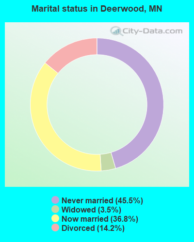
- Never married: 45.5%
- Now married: 36.8%
- Separated: 0.0%
- Widowed: 3.5%
- Divorced: 14.2%
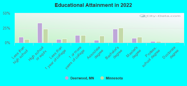
For population 25 years and over in Deerwood:
- High school or higher: 86.0%
- Bachelor's degree or higher: 28.2%
- Graduate or professional degree: 8.4%
- Unemployed: 5.2%
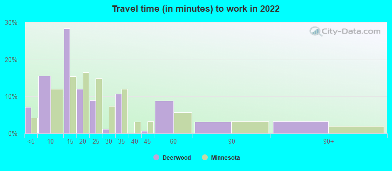
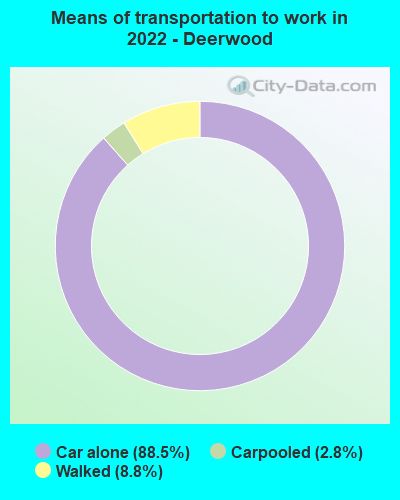
- Mean travel time to work (commute): 24.5 minutes
| Here: | 11.3 |
| Minnesota average: | 10.9 |
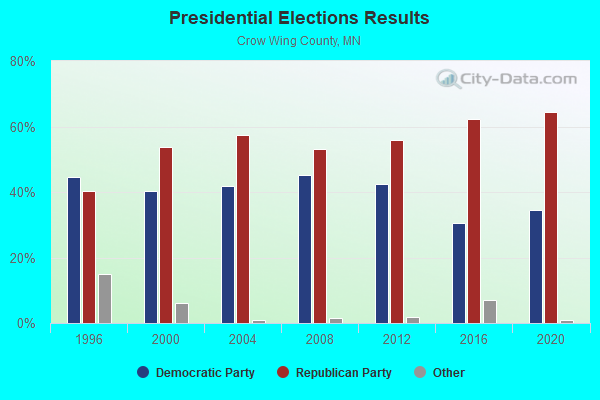
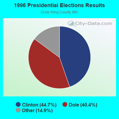
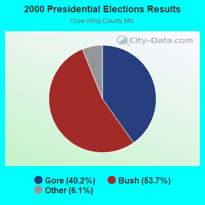
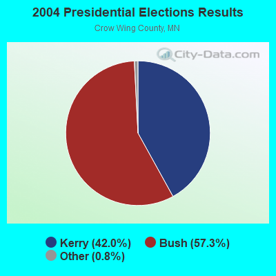
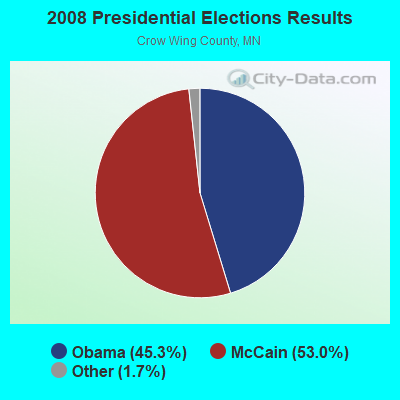
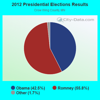

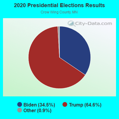
Graphs represent county-level data. Detailed 2008 Election Results
Religion statistics for Deerwood, MN (based on Crow Wing County data)

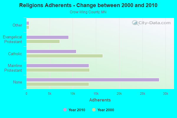
| Religion | Adherents | Congregations |
|---|---|---|
| Mainline Protestant | 13,487 | 23 |
| Catholic | 10,751 | 13 |
| Evangelical Protestant | 9,073 | 49 |
| Other | 587 | 4 |
| None | 28,602 | - |
Food Environment Statistics:
| This county: | 2.11 / 10,000 pop. |
| Minnesota: | 1.83 / 10,000 pop. |
| Here: | 0.33 / 10,000 pop. |
| State: | 0.49 / 10,000 pop. |
| This county: | 6.02 / 10,000 pop. |
| Minnesota: | 3.90 / 10,000 pop. |
| Crow Wing County: | 11.54 / 10,000 pop. |
| Minnesota: | 6.98 / 10,000 pop. |
| This county: | 6.7% |
| Minnesota: | 6.5% |
| Crow Wing County: | 27.2% |
| Minnesota: | 25.9% |
| Crow Wing County: | 8.0% |
| Minnesota: | 13.0% |
Health and Nutrition:
| Deerwood: | 50.8% |
| Minnesota: | 50.6% |
| Deerwood: | 46.9% |
| Minnesota: | 48.4% |
| This city: | 29.5 |
| Minnesota: | 28.5 |
| Here: | 22.8% |
| Minnesota: | 21.0% |
| Deerwood: | 12.9% |
| Minnesota: | 9.8% |
| Deerwood: | 6.8 |
| State: | 6.8 |
| This city: | 38.5% |
| State: | 33.5% |
| Deerwood: | 55.4% |
| State: | 57.7% |
| Here: | 75.4% |
| State: | 79.3% |
More about Health and Nutrition of Deerwood, MN Residents
| Local government employment and payroll (March 2022) | |||||
| Function | Full-time employees | Monthly full-time payroll | Average yearly full-time wage | Part-time employees | Monthly part-time payroll |
|---|---|---|---|---|---|
| Streets and Highways | 2 | $14,070 | $84,420 | 0 | $0 |
| Police Protection - Officers | 2 | $14,862 | $89,172 | 0 | $0 |
| Other Government Administration | 1 | $6,843 | $82,116 | 10 | $3,372 |
| Firefighters | 0 | $0 | 35 | $12,752 | |
| Other and Unallocable | 0 | $0 | 1 | $770 | |
| Totals for Government | 5 | $35,775 | $85,860 | 46 | $16,894 |
Deerwood government finances - Expenditure in 2021 (per resident):
- Current Operations - Police Protection: $281,000 ($482.82)
Local Fire Protection: $192,000 ($329.90)
General - Other: $170,000 ($292.10)
Regular Highways: $154,000 ($264.60)
Water Utilities: $136,000 ($233.68)
Sewerage: $115,000 ($197.59)
Parks and Recreation: $48,000 ($82.47)
Financial Administration: $46,000 ($79.04)
Miscellaneous Commercial Activities - Other: $23,000 ($39.52)
Central Staff Services: $11,000 ($18.90)
- General - Interest on Debt: $21,000 ($36.08)
- Other Capital Outlay - Water Utilities: $1,162,000 ($1996.56)
Local Fire Protection: $10,000 ($17.18)
- Water Utilities - Interest on Debt: $10,000 ($17.18)
Deerwood government finances - Revenue in 2021 (per resident):
- Charges - Other: $266,000 ($457.04)
Sewerage: $104,000 ($178.69)
- Federal Intergovernmental - Housing and Community Development: $60,000 ($103.09)
Health and Hospitals: $40,000 ($68.73)
- Local Intergovernmental - Other: $150,000 ($257.73)
- Miscellaneous - General Revenue - Other: $79,000 ($135.74)
Special Assessments: $50,000 ($85.91)
Interest Earnings: $5,000 ($8.59)
Fines and Forfeits: $3,000 ($5.15)
- Revenue - Water Utilities: $1,083,000 ($1860.82)
- State Intergovernmental - Water Utilities: $703,000 ($1207.90)
Other: $59,000 ($101.37)
General Local Government Support: $20,000 ($34.36)
- Tax - Property: $552,000 ($948.45)
Other License: $14,000 ($24.05)
Deerwood government finances - Debt in 2021 (per resident):
- Long Term Debt - Outstanding Unspecified Public Purpose: $1,579,000 ($2713.06)
Beginning Outstanding - Unspecified Public Purpose: $961,000 ($1651.20)
Issue, Unspecified Public Purpose: $695,000 ($1194.16)
Retired Unspecified Public Purpose: $78,000 ($134.02)
Deerwood government finances - Cash and Securities in 2021 (per resident):
- Sinking Funds - Cash and Securities: $920,000 ($1580.76)
| Businesses in Deerwood, MN | ||||
| Name | Count | Name | Count | |
|---|---|---|---|---|
| Ace Hardware | 1 | La-Z-Boy | 1 | |
| FedEx | 1 | True Value | 1 | |
Strongest AM radio stations in Deerwood:
- KKIN (930 AM; 2 kW; AITKIN, MN; Owner: QUARNSTROM MEDIA GROUP, LLC)
- KLIZ (1380 AM; 5 kW; BRAINERD, MN; Owner: KOMMERSTAD COMMUNICATIONS COMPANY. LLC)
- WEBC (560 AM; 50 kW; DULUTH, MN)
- WWWI (1270 AM; 5 kW; BAXTER, MN; Owner: TOWER BROADCASTING CORPORATION)
- KPRM (870 AM; 25 kW; PARK RAPIDS, MN; Owner: DE LA HUNT BROADCASTING CORP.)
- WCCO (830 AM; 50 kW; MINNEAPOLIS, MN; Owner: INFINITY MEDIA CORPORATION)
- WBHR (660 AM; 10 kW; SAUK RAPIDS, MN; Owner: HERBERT M. HOPPE)
- KLTF (960 AM; 5 kW; LITTLE FALLS, MN; Owner: KLTF/KFML, INC.)
- WCTS (1030 AM; 50 kW; MAPLEWOOD, MN; Owner: CNTL. BAPT. THEO/AL SEMI MINNEAPOLIS)
- KVBR (1340 AM; 1 kW; BRAINERD, MN; Owner: KOMMERSTAD COMMUNICATIONS COMPANY. LLC)
- KSTP (1500 AM; 50 kW; ST. PAUL, MN; Owner: KSTP-AM, LLC (DELAWARE))
- KFAN (1130 AM; 50 kW; MINNEAPOLIS, MN; Owner: AMFM RADIO LICENSES, L.L.C.)
- WNMT (650 AM; 10 kW; NASHWAUK, MN; Owner: MIDWEST RADIO NETWORK, L.L.C.)
Strongest FM radio stations in Deerwood:
- KUAL-FM (101.5 FM; CROSBY, MN; Owner: BL BROADCASTING, INC.)
- KKIN-FM (94.3 FM; AITKIN, MN; Owner: QUARNSTROM MEDIA GROUP, LLC)
- KTIG (102.7 FM; PEQUOT LAKES, MN; Owner: MINNESOTA CHRISTIAN B/CASTERS, INC.)
- KLKS (104.3 FM; BREEZY POINT, MN; Owner: LAKES BROADCASTING GROUP, INC.)
- WJJY-FM (106.7 FM; BRAINERD, MN; Owner: BL BROADCASTING, INC.)
- KLIZ-FM (107.5 FM; BRAINERD, MN; Owner: KOMMERSTAD COMMUNICATIONS COMPANY, LLC)
- KBPR (90.7 FM; BRAINERD, MN; Owner: MINNESOTA PUBLIC RADIO INC.)
- KFGI (103.5 FM; BRAINERD, MN; Owner: KOMMERSTAD COMMUNICATIONS COMPANY, LLC)
- KBLB (93.3 FM; NISSWA, MN; Owner: BL BROADCASTING, INC.)
- KBKK (95.9 FM; PILLAGER, MN; Owner: DJ BROADCASTING C0RPORATION)
- K204ES (88.7 FM; BRAINERD, MN; Owner: CALVARY CHAPEL OF TWIN FALLS, INC.)
TV broadcast stations around Deerwood:
- K25GD (Channel 25; AITKIN, MN; Owner: KBJR LICENSE, INC.)
- K33ET (Channel 33; AITKIN, MN; Owner: CHELSEY BROADCASTING COMPANY OF DULUTH, LLC)
- K27EV (Channel 27; AITKIN, MN; Owner: WDIO-TV, LLC)
- K39GG (Channel 39; AITKIN, MN; Owner: KQDS ACQUISITION CORP.)
- K16BQ (Channel 16; BRAINERD, MN; Owner: HUBBARD BROADCASTING, INC.)
- K28DF (Channel 28; BRAINERD, MN; Owner: FOX TELEVISION STATIONS, INC.)
- K57BJ (Channel 57; BRAINERD, MN; Owner: WDIO-TV, LLC)
- KAWB (Channel 22; BRAINERD, MN; Owner: NORTHERN MN PUBLIC TELEVISION INC.)
- KLKS-LP (Channel 46; BREEZY POINT, MN; Owner: LAKES BROADCASTING GROUP, INC.)
- KCCW-TV (Channel 12; WALKER, MN; Owner: CBS BROADCASTING INC.)
- K54AT (Channel 54; BRAINERD, MN; Owner: RED RIVER BROADCAST CO., LLC)
Deerwood fatal accident list:
Jul 4, 1980 02:38 AM, Vehicles: 1, Persons: 1, Fatalities: 1, Drunk persons involved: 1
Oct 19, 1978 04:42 PM, Vehicles: 2, Persons: 2, Fatalities: 1
FCC Registered Cell Phone Towers:
1 (See the full list of FCC Registered Cell Phone Towers in Deerwood)FCC Registered Antenna Towers:
22 (See the full list of FCC Registered Antenna Towers)FCC Registered Broadcast Land Mobile Towers:
4- Fire Hall 1 Blk E & 1 Blk N St Hwy 210 (Lat: 46.474694 Lon: -93.899139), Call Sign: WNBN273,
Assigned Frequencies: 154.190 MHz, 154.295 MHz, Grant Date: 01/13/2005, Expiration Date: 01/16/2015, Cancellation Date: 03/21/2015, Registrant: City Of Deerwood, 23770 Forest Road, Deerwood, MN 56444, Phone: (218) 534-3152, Fax: (218) 534-3152, Email:
- Lat: 46.391917 Lon: -93.863861, Call Sign: WST680,
Assigned Frequencies: 151.535 MHz, 151.595 MHz, 151.655 MHz, 151.745 MHz, 151.805 MHz, Grant Date: 11/22/2014, Expiration Date: 12/07/2024, Registrant: Advanced Wireless Communications, 20809 Kensington Blvd, Lakeville, MN 55044-8353, Phone: (952) 469-0224, Fax: (952) 469-0170, Email:
- Deerwood Depot, Bnsf Ls27 Mp101.9 - Deerwood Depot (Lat: 46.473333 Lon: -93.899167), Type: Ltower, Structure height: 36.6 m, Call Sign: WNFV896,
Assigned Frequencies: 161.100 MHz, 161.160 MHz, Grant Date: 05/20/2021, Expiration Date: 04/15/2031, Registrant: Bnsf Railway Co., 4515 Kansas Ave, Kansas City, KS 66106, Phone: (913) 551-4015, Fax: (913) 551-4053, Email:
- Lat: 46.502611 Lon: -93.854917, Call Sign: WPWY408,
Assigned Frequencies: 456.312 MHz, 467.862 MHz, 468.312 MHz, Grant Date: 02/07/2023, Expiration Date: 02/07/2033, Certifier: Dale Lundgren, Registrant: Federal Licensing In, 1588 Fairfield Road, Gettysburg, PA 17325, Phone: (717) 334-9262, Fax: (717) 334-6440, Email:
FCC Registered Microwave Towers:
2- DEERWOOD, 2.5 Mi Wsw Of St Hwys 32 & 210 (Lat: 46.491944 Lon: -93.873889), Type: Tower, Structure height: 108.2 m, Overall height: 114.3 m, Call Sign: WPNB280,
Assigned Frequencies: 6375.14 MHz, 6315.84 MHz, 6004.50 MHz, 6315.84 MHz, Grant Date: 02/15/2011, Expiration Date: 02/01/2021, Cancellation Date: 02/28/2014, Certifier: Elizabeth L Kohler, Registrant: Verizon Wireless, 1120 Sanctuary Pkwy, #150 Gasa5reg, Alpharetta, GA 30009-7630, Phone: (770) 797-1070, Fax: (770) 797-1036, Email:
- BAY LAKE, 16352 Crooked Lake Road (Lat: 46.394944 Lon: -93.887417), Type: Ltower, Structure height: 59.4 m, Overall height: 61 m, Call Sign: WQRE988,
Assigned Frequencies: 10815.0 MHz, 10775.0 MHz, 10815.0 MHz, 10895.0 MHz, 10855.0 MHz, 10895.0 MHz, Grant Date: 03/28/2023, Expiration Date: 04/30/2033, Certifier: John E Monday, Registrant: At&t Services, Inc., 208 S Akard St, 20f, Dallas, TX 75202, Phone: (855) 699-7073, Email:
FCC Registered Paging Towers:
1- 2.5 Mi Wsw Of St Hwys 32 & 210 (Lat: 46.491944 Lon: -93.873889), Type: Tower, Structure height: 108.2 m, Overall height: 114.3 m, Call Sign: KNKO696, Licensee ID: L00123266,
Assigned Frequencies: 931.337 MHz, Grant Date: 12/27/2019, Expiration Date: 11/08/2029, Certifier: J. Roy Pottle, Registrant: Ams Spectrum Holdings, LLC
FCC Registered Amateur Radio Licenses:
29 (See the full list of FCC Registered Amateur Radio Licenses in Deerwood)FAA Registered Aircraft:
7- Aircraft: BELLANCA 17-30A (Category: Land, Seats: 4, Weight: Up to 12,499 Pounds, Speed: 142 mph), Engine: CONT MOTOR IO 520 SERIES (285 HP) (Reciprocating)
N-Number: 1289R, N1289R, N-1289R, Serial Number: 30417, Year manufactured: 1972, Airworthiness Date: 01/12/1972, Certificate Issue Date: 10/04/2010
Registrant (Individual): Blanc Rick M Le, Po Box 444, Deerwood, MN 56444 - Aircraft: HAKES JAMES WELTON KITFOX IV (Category: Amphibian, Seats: 2, Weight: Up to 12,499 Pounds), Engine: AMA/EXPR UNKNOWN ENG (Reciprocating)
N-Number: 1664K, N1664K, N-1664K, Serial Number: 1664, Year manufactured: 1996, Airworthiness Date: 07/24/1996, Certificate Issue Date: 02/26/1996
Registrant (Individual): James W Hakes, 23458 Agate Lake Rd, Deerwood, MN 56444 - Aircraft: MAULE MXT-7-180A (Category: Land, Seats: 5, Weight: Up to 12,499 Pounds), Engine: Reciprocating
N-Number: 3187A, N3187A, N-3187A, Serial Number: 21011C, Certificate Issue Date: 04/27/2020
Registrant (Individual): Tony G Nelson, 19836 Linberg Rd, Deerwood, MN 56444 - Aircraft: STEPHEN B EMMETT RV-9A (Category: Land, Seats: 2, Weight: Up to 12,499 Pounds), Engine: AMA/EXPR UNKNOWN ENG (Reciprocating)
N-Number: 43KK, N43KK, N-43KK, Serial Number: 91059, Year manufactured: 2011, Airworthiness Date: 10/17/2011, Certificate Issue Date: 11/18/2020
Registrant (Individual): Howard M Mccollister, 21796 Peterson Creek Dr, Deerwood, MN 56444 - Aircraft: CESSNA 175A (Category: Land, Seats: 4, Weight: Up to 12,499 Pounds, Speed: 105 mph), Engine: CONT MOTOR GO-300 SERIES (175 HP) (Reciprocating)
N-Number: 6746E, N6746E, N-6746E, Serial Number: 56246, Year manufactured: 1959, Airworthiness Date: 11/10/1959, Certificate Issue Date: 07/15/2015
Registrant (Individual): Marcel A Kobberdahl, 19344 Lakewood Dr, Deerwood, MN 56444 - Aircraft: PIPER PA-32-300 (Category: Land, Seats: 6, Weight: Up to 12,499 Pounds, Speed: 126 mph), Engine: LYCOMING TI0-540 SER (310 HP) (Reciprocating)
N-Number: 8683N, N8683N, N-8683N, Serial Number: 32-7240026, Year manufactured: 1971, Airworthiness Date: 09/29/1971, Certificate Issue Date: 03/13/2019
Registrant (LLC): Airwide LLC, 26384 County Road 133, Deerwood, MN 56444 - Aircraft: PIPER PA-28-235 (Category: Land, Seats: 4, Weight: Up to 12,499 Pounds, Speed: 107 mph), Engine: LYCOMING 0-540 SERIES (250 HP) (Reciprocating)
N-Number: 9450W, N9450W, N-9450W, Serial Number: 28-11169, Year manufactured: 1968, Airworthiness Date: 10/09/1968, Certificate Issue Date: 05/22/2018
Registrant (LLC): Airwide LLC, 26384 County Road 133, Deerwood, MN 56444
2002 - 2018 National Fire Incident Reporting System (NFIRS) incidents
- Fire incident types reported to NFIRS in Deerwood, MN
- 15943.1%Structure Fires
- 12433.6%Outside Fires
- 4913.3%Other
- 3710.0%Mobile Property/Vehicle Fires
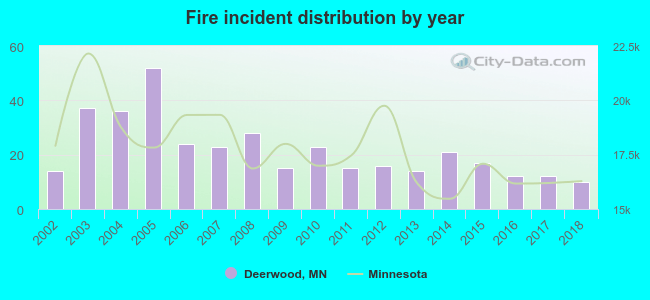 According to the data from the years 2002 - 2018 the average number of fires per year is 22. The highest number of reported fires - 52 took place in 2005, and the least - 10 in 2018. The data has a dropping trend.
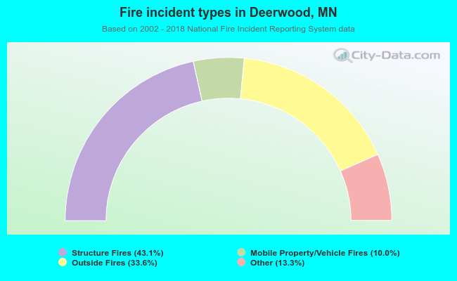 When looking into fire subcategories, the most incidents belonged to: Structure Fires (43.1%), and Outside Fires (33.6%).
Fire-safe hotels and motels in Deerwood, Minnesota:
- Ruttger's Bay Lake Lodge, Rt 2, Deerwood, Minnesota 56444 , Phone: (218) 678-2885, Fax: (218) 648-2864
- Country Inn By Carlson Deerwood, 23884 Front St, Deerwood, Minnesota 56444 , Phone: (218) 534-3101, Fax: (218) 534-3685
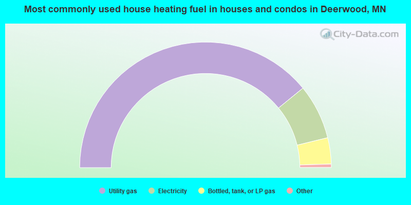
- 78.9%Utility gas
- 14.3%Electricity
- 6.8%Bottled, tank, or LP gas
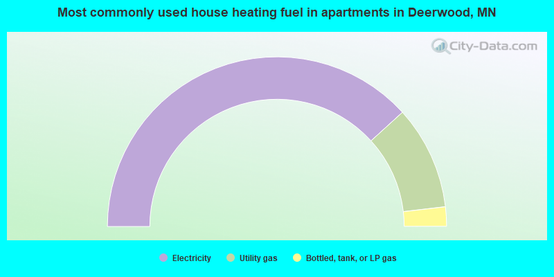
- 76.5%Electricity
- 19.8%Utility gas
- 3.7%Bottled, tank, or LP gas
Deerwood compared to Minnesota state average:
- Median household income below state average.
- Unemployed percentage below state average.
- Black race population percentage significantly below state average.
- Hispanic race population percentage below state average.
- Foreign-born population percentage significantly below state average.
- Length of stay since moving in significantly below state average.
- Number of college students below state average.

|
Total of 3 patent applications in 2008-2024.