Holt, Missouri
Submit your own pictures of this city and show them to the world
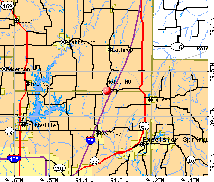
- OSM Map
- General Map
- Google Map
- MSN Map
Population change since 2000: +16.3%
 |
| Males: 236 | |
| Females: 235 |
| Median resident age: | 38.2 years |
| Missouri median age: | 39.1 years |
Zip codes: 64048.
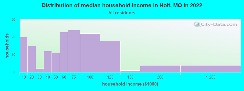
| Holt: | $57,393 |
| MO: | $64,811 |
Estimated per capita income in 2022: $28,094 (it was $16,841 in 2000)
Holt city income, earnings, and wages data
Estimated median house or condo value in 2022: $178,702 (it was $76,400 in 2000)
| Holt: | $178,702 |
| MO: | $221,200 |
Mean prices in 2022: all housing units: $164,867; detached houses: $161,891
Median gross rent in 2022: $823.
Detailed information about poverty and poor residents in Holt, MO

Compare current foreclosures near Holt, MO:
| Photo | Address | Area | Beds / Baths | Price | Details |
|---|---|---|---|---|---|

|
#1
NE 176th St
Holt, MO 64048
|
1,368 sq. feet
|
2 baths 4 beds |
show details | |

|
#2
Crestview Cir
Holt, MO 64048
|
1,416 sq. feet
|
2 baths 3 beds |
show details | |

|
#3
S C Hwy
Holt, MO 64048
|
- sq. feet
|
- baths - beds |
show details | |

|
#4
Adams Rd
Rayville, MO 64084
|
2,064 sq. feet
|
4 baths 4 beds |
$334,900
|
show details |

|
#5
Cottonwood Creek Ct
Kearney, MO 64060
|
- sq. feet
|
2 baths 3 beds |
show details | |

|
#6
NE 114th St
Kansas City, MO 64155
|
1,214 sq. feet
|
2 baths 3 beds |
show details | |

|
#7
W 108th St
Orrick, MO 64077
|
5,504 sq. feet
|
5 baths 4 beds |
show details | |

|
#8
Richfield Ct
Liberty, MO 64068
|
1,046 sq. feet
|
3 baths 3 beds |
show details | |

|
#9
N Kensington Ct
Kansas City, MO 64156
|
1,440 sq. feet
|
2 baths 3 beds |
show details | |

|
#10
Maple Ave
Smithville, MO 64089
|
1,898 sq. feet
|
1 baths 3 beds |
show details |
| Photo | Address | Area | Beds / Baths | Price | Details |
|---|---|---|---|---|---|

|
#11
N Skiles Ave
Kansas City, MO 64157
|
1,024 sq. feet
|
2 baths 4 beds |
show details | |

|
#12
N Marsh Ave
Kansas City, MO 64157
|
1,113 sq. feet
|
2 baths 3 beds |
show details | |

|
#13
NE 110th Ter
Kansas City, MO 64157
|
993 sq. feet
|
2 baths 3 beds |
show details | |

|
#14
Jolisa Ct
Smithville, MO 64089
|
888 sq. feet
|
2 baths 2 beds |
show details | |

|
#15
S Leonard St
Liberty, MO 64068
|
1,267 sq. feet
|
2 baths 3 beds |
show details | |

|
#16
NE 115th Ter
Kansas City, MO 64157
|
1,056 sq. feet
|
2 baths 3 beds |
show details | |

|
#17
W Franklin St
Liberty, MO 64068
|
1,046 sq. feet
|
2 baths 3 beds |
show details | |

|
#18
S Forrest Ave
Liberty, MO 64068
|
1,526 sq. feet
|
3 baths 3 beds |
show details | |

|
#19
N Kentucky Ct
Kansas City, MO 64157
|
1,294 sq. feet
|
2 baths 3 beds |
show details | |

|
#20
N Wayne Ave
Kansas City, MO 64155
|
1,150 sq. feet
|
2 baths 3 beds |
show details |
| Photo | Address | Area | Beds / Baths | Price | Details |
|---|---|---|---|---|---|

|
#21
NE 109th Ter
Kansas City, MO 64155
|
1,785 sq. feet
|
3 baths 3 beds |
show details | |

|
#22
Maple St
Liberty, MO 64068
|
900 sq. feet
|
2 baths 2 beds |
show details | |

|
#23
Coneflower St
Smithville, MO 64089
|
1,113 sq. feet
|
2 baths 3 beds |
show details | |

|
#24
N Jefferson Ave
Liberty, MO 64068
|
1,240 sq. feet
|
1 baths 3 beds |
show details | |

|
#25
Rollins Dr
Smithville, MO 64089
|
1,673 sq. feet
|
4 baths 1 beds |
show details | |

|
#26
Oxford Ct
Liberty, MO 64068
|
1,358 sq. feet
|
2 baths 3 beds |
show details | |

|
#27
Sherman Dr
Liberty, MO 64068
|
1,539 sq. feet
|
2 baths 3 beds |
show details | |

|
#28
NE 119th Ter
Kansas City, MO 64156
|
1,812 sq. feet
|
2 baths 2 beds |
show details | |

|
#29
N Lawn Ave
Kansas City, MO 64156
|
1,514 sq. feet
|
3 baths 4 beds |
show details | |

|
#30
Aspen Cir
Smithville, MO 64089
|
1,454 sq. feet
|
2 baths 3 beds |
show details |
| Photo | Address | Area | Beds / Baths | Price | Details |
|---|---|---|---|---|---|

|
#31
S Commercial Ave
Smithville, MO 64089
|
2,076 sq. feet
|
2 baths 3 beds |
show details | |

|
#32
N Lightburne St
Liberty, MO 64068
|
1,578 sq. feet
|
1 baths 4 beds |
show details | |

|
#33
NE 98th Ter
Kansas City, MO 64157
|
1,122 sq. feet
|
2 baths 3 beds |
show details | |

|
#34
S Jewell St
Liberty, MO 64068
|
2,002 sq. feet
|
1 baths 3 beds |
show details | |

|
#35
Shannon Ave
Smithville, MO 64089
|
1,674 sq. feet
|
3 baths 3 beds |
show details | |

|
#36
Wicklow St
Smithville, MO 64089
|
1,233 sq. feet
|
2 baths 3 beds |
show details | |

|
#37
Dexter St
Liberty, MO 64068
|
1,112 sq. feet
|
3 baths 4 beds |
show details | |

|
#38
N Marsh Ave
Kansas City, MO 64157
|
1,036 sq. feet
|
2 baths 4 beds |
show details | |

|
#39
N Grover St
Liberty, MO 64068
|
728 sq. feet
|
1 baths 2 beds |
show details | |

|
#40
Ridgeway Dr
Liberty, MO 64068
|
972 sq. feet
|
3 baths 4 beds |
show details |
| Photo | Address | Area | Beds / Baths | Price | Details |
|---|---|---|---|---|---|

|
#41
N Wallace Ave
Kansas City, MO 64157
|
1,731 sq. feet
|
3 baths 3 beds |
show details | |

|
#42
Walker Ct
Liberty, MO 64068
|
1,216 sq. feet
|
2 baths 3 beds |
show details | |

|
#43
W Summit St
Smithville, MO 64089
|
1,449 sq. feet
|
2 baths 3 beds |
show details | |

|
#44
NE 107th Ter
Kansas City, MO 64157
|
1,182 sq. feet
|
2 baths 3 beds |
show details | |

|
#45
Northwyck Dr
Liberty, MO 64068
|
1,258 sq. feet
|
2 baths 3 beds |
show details | |

|
#46
N Ash Ave
Kansas City, MO 64157
|
1,362 sq. feet
|
2 baths 3 beds |
show details | |

|
#47
NE 108th Ter
Kansas City, MO 64157
|
1,337 sq. feet
|
2 baths 3 beds |
show details | |

|
#48
Sherman Dr
Liberty, MO 64068
|
1,665 sq. feet
|
3 baths 3 beds |
show details | |

|
#49
NE 97th Ter
Kansas City, MO 64157
|
646 sq. feet
|
2 baths 2 beds |
show details | |

|
Check over 1 million property listings on Foreclosure.com!
|
browse all offers | |||


- 31288.1%White alone
- 215.9%Hispanic
- 102.8%Two or more races
- 30.8%Asian alone
- 20.6%Other race alone
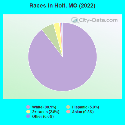
Races in Holt detailed stats: ancestries, foreign born residents, place of birth
According to our research of Missouri and other state lists, there were 12 registered sex offenders living in Holt, Missouri as of April 30, 2024.
The ratio of all residents to sex offenders in Holt is 43 to 1.
 Recent articles from our blog. Our writers, many of them Ph.D. graduates or candidates, create easy-to-read articles on a wide variety of topics.

 | Most popular CFB Teams besides Mizzou (0 replies) |
| Moving Back after 15 years (2 replies) |
| St. Louis to remove Confederate monument (485 replies) |
| Interesting Missouri facts. (1186 replies) |
| Missouri Outlaw History (3407 replies) |
| Where in Missouri does the South begin? (507 replies) |
Latest news from Holt, MO collected exclusively by city-data.com from local newspapers, TV, and radio stations
Ancestries: German (18.1%), English (12.6%), American (6.3%), European (6.3%), French (3.9%), Irish (3.9%).
Current Local Time: CST time zone
Incorporated in 1867
Elevation: 860 feet
Land area: 0.36 square miles.
Population density: 1,302 people per square mile (low).
3 residents are foreign born
| This city: | 0.8% |
| Missouri: | 4.2% |
Median real estate property taxes paid for housing units with mortgages in 2022: $1,594 (0.9%)
Median real estate property taxes paid for housing units with no mortgage in 2022: $1,574 (1.2%)
Nearest city with pop. 50,000+: Independence, MO  (26.3 miles , pop. 113,288).
Nearest city with pop. 200,000+: Kansas City, MO (28.8 miles , pop. 441,545).
Nearest city with pop. 1,000,000+: Chicago, IL (386.2 miles , pop. 2,896,016).
Nearest cities:
), ), ), ), )Latitude: 39.46 N, Longitude: 94.34 W
Area code: 816

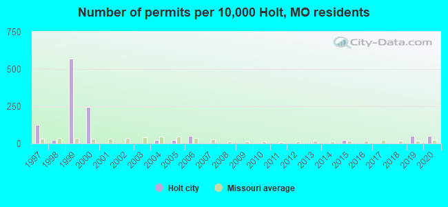
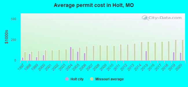
Single-family new house construction building permits:
- 2020: 2 buildings, average cost: $95,000
- 2019: 2 buildings, average cost: $102,500
- 2015: 1 building, cost: $115,000
- 2006: 2 buildings, average cost: $90,000
- 2005: 1 building, cost: $108,000
- 2004: 1 building, cost: $162,700
- 2000: 10 buildings, average cost: $65,000
- 1999: 23 buildings, average cost: $41,700
- 1998: 1 building, cost: $82,000
- 1997: 5 buildings, average cost: $38,800
| Here: | 2.4% |
| Missouri: | 2.8% |

- Construction (30.3%)
- Accommodation & food services (9.0%)
- Health care (8.5%)
- Food & beverage stores (8.0%)
- Professional, scientific, technical services (4.3%)
- U. S. Postal service (3.7%)
- Groceries & related products merchant wholesalers (3.2%)
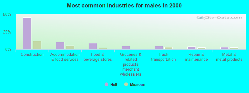
- Construction (45.6%)
- Accommodation & food services (10.4%)
- Food & beverage stores (8.8%)
- Groceries & related products merchant wholesalers (4.8%)
- Truck transportation (4.8%)
- Repair & maintenance (4.0%)
- Metal & metal products (3.2%)
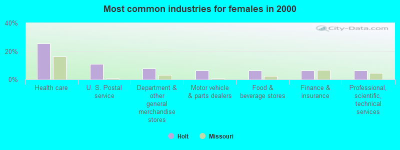
- Health care (25.4%)
- U. S. Postal service (11.1%)
- Department & other general merchandise stores (7.9%)
- Motor vehicle & parts dealers (6.3%)
- Food & beverage stores (6.3%)
- Finance & insurance (6.3%)
- Professional, scientific, technical services (6.3%)
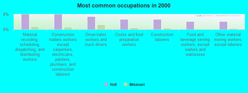
- Material recording, scheduling, dispatching, and distributing workers (8.0%)
- Construction traders workers except carpenters, electricians, painters, plumbers, and construction laborers (8.0%)
- Driver/sales workers and truck drivers (6.9%)
- Cooks and food preparation workers (5.3%)
- Construction laborers (5.3%)
- Food and beverage serving workers, except waiters and waitresses (4.3%)
- Other material moving workers, except laborers (4.3%)
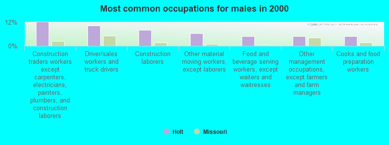
- Construction traders workers except carpenters, electricians, painters, plumbers, and construction laborers (12.0%)
- Driver/sales workers and truck drivers (10.4%)
- Construction laborers (8.0%)
- Other material moving workers, except laborers (6.4%)
- Food and beverage serving workers, except waiters and waitresses (4.8%)
- Other management occupations, except farmers and farm managers (4.8%)
- Cooks and food preparation workers (4.8%)
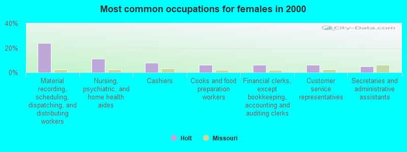
- Material recording, scheduling, dispatching, and distributing workers (23.8%)
- Nursing, psychiatric, and home health aides (11.1%)
- Cashiers (7.9%)
- Cooks and food preparation workers (6.3%)
- Financial clerks, except bookkeeping, accounting and auditing clerks (6.3%)
- Customer service representatives (6.3%)
- Secretaries and administrative assistants (4.8%)
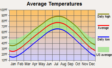
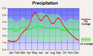
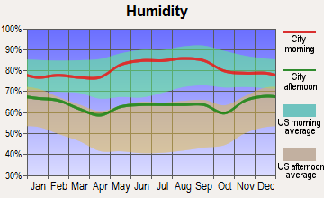
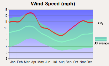
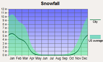
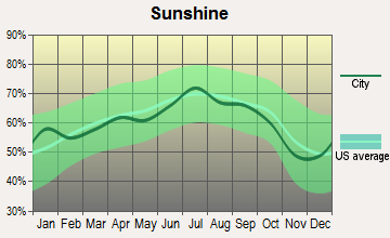
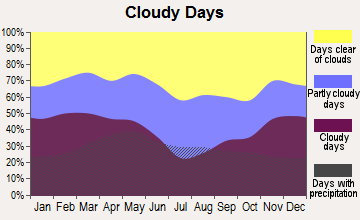
Average climate in Holt, Missouri
Based on data reported by over 4,000 weather stations
(lower is better)
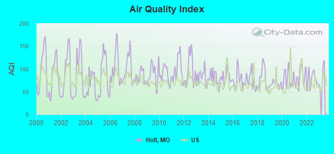
Air Quality Index (AQI) level in 2022 was 76.5. This is about average.
| City: | 76.5 |
| U.S.: | 72.6 |
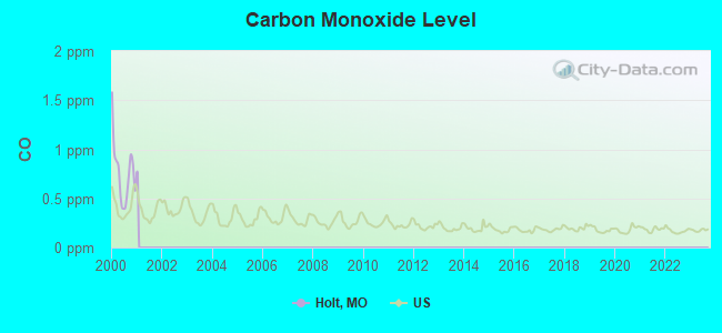
Carbon Monoxide (CO) [ppm] level in 2000 was 0.768. This is significantly worse than average. Closest monitor was 22.3 miles away from the city center.
| City: | 0.768 |
| U.S.: | 0.251 |
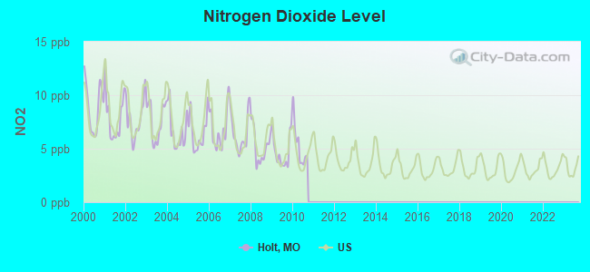
Nitrogen Dioxide (NO2) [ppb] level in 2010 was 5.32. This is about average. Closest monitor was 10.8 miles away from the city center.
| City: | 5.32 |
| U.S.: | 5.11 |
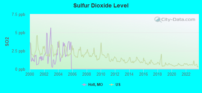
Sulfur Dioxide (SO2) [ppb] level in 2005 was 2.90. This is significantly worse than average. Closest monitor was 20.7 miles away from the city center.
| City: | 2.90 |
| U.S.: | 1.51 |
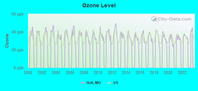
Ozone [ppb] level in 2022 was 34.6. This is about average. Closest monitor was 5.1 miles away from the city center.
| City: | 34.6 |
| U.S.: | 33.3 |
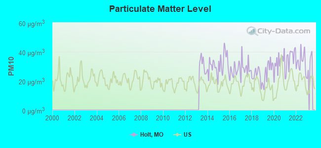
Particulate Matter (PM10) [µg/m3] level in 2022 was 32.9. This is significantly worse than average. Closest monitor was 24.8 miles away from the city center.
| City: | 32.9 |
| U.S.: | 19.2 |
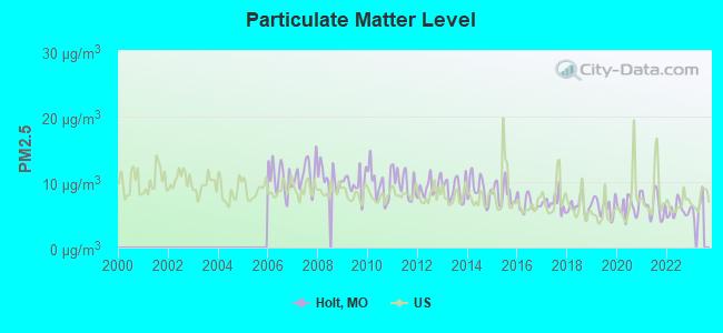
Particulate Matter (PM2.5) [µg/m3] level in 2022 was 5.66. This is significantly better than average. Closest monitor was 10.8 miles away from the city center.
| City: | 5.66 |
| U.S.: | 8.11 |
Tornado activity:
Holt-area historical tornado activity is slightly above Missouri state average. It is 90% greater than the overall U.S. average.
On 5/7/1961, a category F4 (max. wind speeds 207-260 mph) tornado 13.0 miles away from the Holt city center injured 12 people and caused between $500,000 and $5,000,000 in damages.
On 5/20/1957, a category F5 (max. wind speeds 261-318 mph) tornado 33.2 miles away from the city center killed 44 people and injured 207 people and caused between $500,000 and $5,000,000 in damages.
Earthquake activity:
Holt-area historical earthquake activity is significantly above Missouri state average. It is 451% greater than the overall U.S. average.On 9/3/2016 at 12:02:44, a magnitude 5.8 (5.8 MW, Depth: 3.5 mi, Class: Moderate, Intensity: VI - VII) earthquake occurred 252.9 miles away from Holt center
On 11/6/2011 at 03:53:10, a magnitude 5.7 (5.7 MW, Depth: 3.2 mi) earthquake occurred 302.4 miles away from Holt center
On 11/12/2014 at 21:40:00, a magnitude 4.9 (4.9 MW, Depth: 2.5 mi, Class: Light, Intensity: IV - V) earthquake occurred 233.6 miles away from the city center
On 11/7/2016 at 01:44:24, a magnitude 5.0 (5.0 MW, Depth: 2.8 mi) earthquake occurred 275.1 miles away from Holt center
On 4/18/2008 at 09:36:59, a magnitude 5.4 (5.1 MB, 4.8 MS, 5.4 MW, 5.2 MW) earthquake occurred 353.8 miles away from Holt center
On 2/13/2016 at 17:07:06, a magnitude 5.1 (5.1 MW, Depth: 5.2 mi) earthquake occurred 314.5 miles away from Holt center
Magnitude types: body-wave magnitude (MB), surface-wave magnitude (MS), moment magnitude (MW)
Natural disasters:
The number of natural disasters in Clay County (24) is greater than the US average (15).Major Disasters (Presidential) Declared: 16
Emergencies Declared: 6
Causes of natural disasters: Floods: 17, Storms: 14, Tornadoes: 7, Winter Storms: 3, Drought: 1, Heavy Rain: 1, Hurricane: 1, Ice Storm: 1, Wind: 1, Other: 1 (Note: some incidents may be assigned to more than one category).
Hospitals and medical centers near Holt:
- LATHROP HEALTH CARE FAC, INC (Nursing Home, about 6 miles away; LATHROP, MO)
- LAWSON MANOR AND REHAB (Nursing Home, about 7 miles away; LAWSON, MO)
- VALLEY MANOR AND REHABILITATION CENTER (Nursing Home, about 9 miles away; EXCELSIOR SPRINGS, MO)
- EXCELSIOR SPRINGS HOSPITAL HOME HEALTH/HOSPICE (Home Health Center, about 9 miles away; EXCELSIOR SPRINGS, MO)
- EXCELSIOR SPRINGS MEDICAL CENTER (Nursing Home, about 9 miles away; EXCELSIOR SPRINGS, MO)
- ROYAL CARE CENTER INC (Nursing Home, about 9 miles away; EXCELSIOR SPRINGS, MO)
- OAKRIDGE OF PLATTSBURG (Nursing Home, about 10 miles away; PLATTSBURG, MO)
Airports located in Holt:
- Block Air Village Airport (MO71) (Runways: 3)
- Northwood Airport (2MO2) (Runways: 1)
Colleges/universities with over 2000 students nearest to Holt:
- Grantham University (about 23 miles; Kansas City, MO; Full-time enrollment: 8,385)
- Park University (about 26 miles; Parkville, MO; FT enrollment: 9,131)
- Metropolitan Community College-Kansas City (about 31 miles; Kansas City, MO; FT enrollment: 12,834)
- Missouri Western State University (about 32 miles; Saint Joseph, MO; FT enrollment: 4,557)
- University of Missouri-Kansas City (about 32 miles; Kansas City, MO; FT enrollment: 10,544)
- Kansas City Kansas Community College (about 32 miles; Kansas City, KS; FT enrollment: 4,718)
- Rockhurst University (about 33 miles; Kansas City, MO; FT enrollment: 2,013)
Points of interest:
Notable location: Holt Community Fire Protection District (A). Display/hide its location on the map
Drinking water stations with addresses in Holt and their reported violations in the past:
CLAY CO PWSD 3 (Population served: 3,933, Groundwater):Past health violations:Past monitoring violations:
- MCL, Average - Between JAN-2013 and MAR-2013, Contaminant: TTHM. Follow-up actions: St Compliance achieved (APR-23-2013), St Formal NOV issued (MAY-13-2013), St Public Notif requested (MAY-13-2013), St Public Notif received (JUN-20-2013)
- 3 minor monitoring violations
| This city: | 2.5 people |
| Missouri: | 2.5 people |
| This city: | 67.6% |
| Whole state: | 65.3% |
| This city: | 8.0% |
| Whole state: | 6.7% |
Likely homosexual households (counted as self-reported same-sex unmarried-partner households)
- Lesbian couples: 0.6% of all households
- Gay men: 0.6% of all households
Banks with branches in Holt (2011 data):
- Goppert Financial Bank: Holt Drive-In Facility at Highway 33, branch established on 1974/04/30. Info updated 2008/10/24: Bank assets: $71.7 mil, Deposits: $63.6 mil, headquarters in Lathrop, MO, positive income, Agricultural Specialization, 4 total offices, Holding Company: Goppert Financial Corp.
For population 15 years and over in Holt:
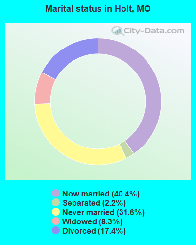
- Never married: 31.6%
- Now married: 40.4%
- Separated: 2.2%
- Widowed: 8.3%
- Divorced: 17.4%
For population 25 years and over in Holt:
- High school or higher: 87.8%
- Bachelor's degree or higher: 14.7%
- Graduate or professional degree: 5.3%
- Unemployed: 11.3%
- Mean travel time to work (commute): 29.4 minutes
| Here: | 8.0 |
| Missouri average: | 11.1 |
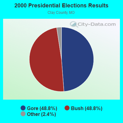
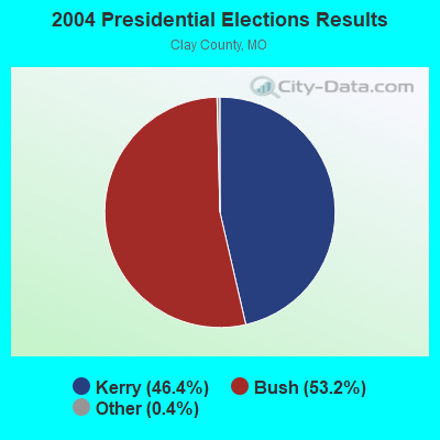
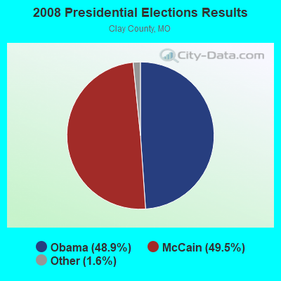
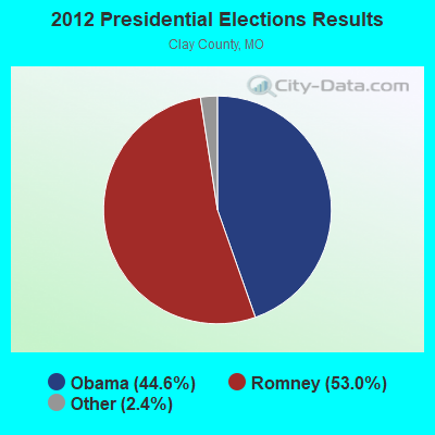
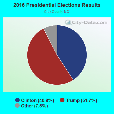
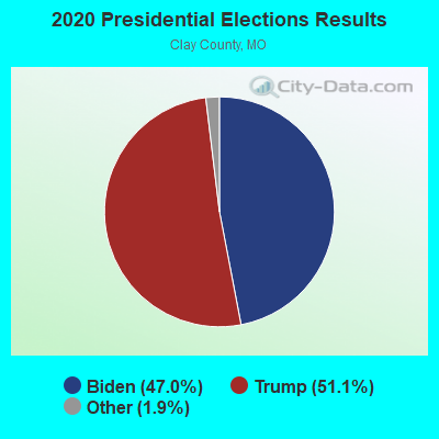
Graphs represent county-level data. Detailed 2008 Election Results
Religion statistics for Holt, MO (based on Clay County data)
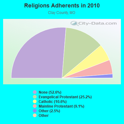
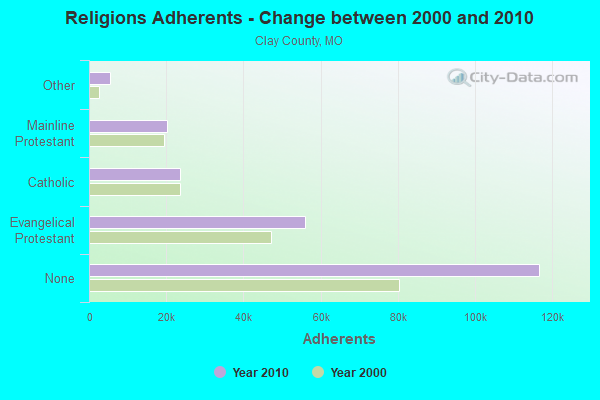
| Religion | Adherents | Congregations |
|---|---|---|
| Evangelical Protestant | 55,953 | 140 |
| Catholic | 23,511 | 9 |
| Mainline Protestant | 20,193 | 41 |
| Other | 5,454 | 23 |
| Black Protestant | 125 | 1 |
| Orthodox | 44 | 1 |
| None | 116,659 | - |
Food Environment Statistics:
| This county: | 1.56 / 10,000 pop. |
| Missouri: | 1.88 / 10,000 pop. |
| This county: | 0.14 / 10,000 pop. |
| State: | 0.18 / 10,000 pop. |
| Clay County: | 0.28 / 10,000 pop. |
| Missouri: | 0.60 / 10,000 pop. |
| Clay County: | 3.12 / 10,000 pop. |
| Missouri: | 4.34 / 10,000 pop. |
| Clay County: | 6.38 / 10,000 pop. |
| Missouri: | 7.37 / 10,000 pop. |
| This county: | 7.9% |
| Missouri: | 8.8% |
| This county: | 30.5% |
| Missouri: | 29.6% |
| Here: | 12.2% |
| State: | 13.5% |
Health and Nutrition:
| This city: | 48.5% |
| Missouri: | 50.9% |
| Holt: | 43.5% |
| Missouri: | 48.6% |
| Holt: | 29.4 |
| State: | 28.7 |
| This city: | 22.0% |
| State: | 20.6% |
| Here: | 13.9% |
| Missouri: | 10.1% |
| Holt: | 6.8 |
| Missouri: | 6.8 |
| Holt: | 34.6% |
| Missouri: | 34.3% |
| Here: | 55.3% |
| Missouri: | 57.5% |
| Here: | 76.6% |
| State: | 79.3% |
More about Health and Nutrition of Holt, MO Residents
| Local government employment and payroll (March 2022) | |||||
| Function | Full-time employees | Monthly full-time payroll | Average yearly full-time wage | Part-time employees | Monthly part-time payroll |
|---|---|---|---|---|---|
| Financial Administration | 0 | $0 | 1 | $320 | |
| Totals for Government | 0 | $0 | 1 | $320 | |
Holt government finances - Expenditure in 2017 (per resident):
- Construction - Sewerage: $10,000 ($21.23)
Water Utilities: $2,000 ($4.25)
Central Staff Services: $2,000 ($4.25)
Financial Administration: $2,000 ($4.25)
Police Protection: $1,000 ($2.12)
- Current Operations - Solid Waste Management: $22,000 ($46.71)
Police Protection: $21,000 ($44.59)
Sewerage: $14,000 ($29.72)
Financial Administration: $14,000 ($29.72)
Water Utilities: $13,000 ($27.60)
Regular Highways: $12,000 ($25.48)
Central Staff Services: $9,000 ($19.11)
Judicial and Legal Services: $5,000 ($10.62)
Parks and Recreation: $2,000 ($4.25)
- General - Interest on Debt: $15,000 ($31.85)
- Other Capital Outlay - Financial Administration: $1,000 ($2.12)
- Total Salaries and Wages: $74,000 ($157.11)
Holt government finances - Revenue in 2017 (per resident):
- Charges - Sewerage: $49,000 ($104.03)
Solid Waste Management: $20,000 ($42.46)
Regular Highways: $1,000 ($2.12)
- Local Intergovernmental - Other: $3,000 ($6.37)
- Miscellaneous - Fines and Forfeits: $5,000 ($10.62)
Interest Earnings: $4,000 ($8.49)
General Revenue - Other: $1,000 ($2.12)
- Revenue - Water Utilities: $63,000 ($133.76)
- State Intergovernmental - Highways: $19,000 ($40.34)
- Tax - Property: $44,000 ($93.42)
General Sales and Gross Receipts: $38,000 ($80.68)
Public Utilities Sales: $22,000 ($46.71)
Individual Income: $3,000 ($6.37)
Holt government finances - Debt in 2017 (per resident):
- Long Term Debt - Beginning Outstanding - Unspecified Public Purpose: $363,000 ($770.70)
Outstanding Unspecified Public Purpose: $354,000 ($751.59)
Retired Unspecified Public Purpose: $9,000 ($19.11)
- Short Term Debt Outstanding - Beginning: $363,000 ($770.70)
End of Fiscal Year: $354,000 ($751.59)
Holt government finances - Cash and Securities in 2017 (per resident):
- Other Funds - Cash and Securities: $264,000 ($560.51)
8.80% of this county's 2021 resident taxpayers lived in other counties in 2020 ($56,910 average adjusted gross income)
| Here: | 8.80% |
| Missouri average: | 7.67% |
0.02% of residents moved from foreign countries ($156 average AGI)
Clay County: 0.02% Missouri average: 0.02%
Top counties from which taxpayers relocated into this county between 2020 and 2021:
| from Jackson County, MO | |
| from Platte County, MO | |
| from Johnson County, KS |
Strongest AM radio stations in Holt:
- WHB (810 AM; 50 kW; KANSAS CITY, MO; Owner: UNION BROADCASTING, INC.)
- KCMO (710 AM; 10 kW; KANSAS CITY, MO; Owner: SUSQUEHANNA KANSAS CITY PARTNERSHIP)
- KKHK (1250 AM; 25 kW; KANSAS CITY, KS)
- KEXS (1090 AM; daytime; 1 kW; EXCELSIOR SPRINGS, MO; Owner: JEFFCO TELEVISION CORP.)
- KCTE (1510 AM; daytime; 10 kW; INDEPENDENCE, MO; Owner: UNION BROADCASTING, INC.)
- KCCV (760 AM; daytime; 6 kW; OVERLAND PARK, KS; Owner: BOTT BROADCASTING COMPANY)
- KCSP (610 AM; 5 kW; KANSAS CITY, MO; Owner: ENTERCOM KANSAS CITY LICENSE, LLC)
- KXTR (1660 AM; 10 kW; KANSAS CITY, KS; Owner: ENTERCOM KANSAS CITY LICENSE, LLC)
- KFEQ (680 AM; 5 kW; ST. JOSEPH, MO; Owner: EAGLE RADIO, INC.)
- KPHN (1190 AM; 5 kW; KANSAS CITY, MO; Owner: ABC, INC.)
- KMBZ (980 AM; 5 kW; KANSAS CITY, MO; Owner: ENTERCOM KANSAS CITY LICENSE, LLC)
- KSFT (1550 AM; 5 kW; ST. JOSEPH, MO; Owner: EAGLE RADIO, INC)
- KKLO (1410 AM; 5 kW; LEAVENWORTH, KS; Owner: CHARA COMMUNICATIONS, INC.)
Strongest FM radio stations in Holt:
- KSRC (102.1 FM; KANSAS CITY, MO; Owner: INFINITY RADIO OPERATIONS INC.)
- WDAF-FM (106.5 FM; LIBERTY, MO; Owner: ENTERCOM KANSAS CITY LICENSE, LLC)
- KUDL (98.1 FM; KANSAS CITY, KS; Owner: ENTERCOM KANSAS CITY LICENSE, LLC)
- KZPL (97.3 FM; LEE'S SUMMIT, MO; Owner: UNION FIRST BROADCASTING, LLC)
- KBEQ-FM (104.3 FM; KANSAS CITY, MO; Owner: INFINITY RADIO SUBSIDIARY OPERATIONS INC.)
- KCMO-FM (94.9 FM; KANSAS CITY, MO; Owner: SUSQUEHANNA KANSAS CITY PARTNERSHIP)
- KQRC-FM (98.9 FM; LEAVENWORTH, KS; Owner: ENTERCOM KANSAS CITY LICENSE, LLC)
- KRBZ (96.5 FM; KANSAS CITY, MO; Owner: ENTERCOM KANSAS CITY LICENSE, LLC)
- KYYS (99.7 FM; KANSAS CITY, MO; Owner: ENTERCOM KANSAS CITY LICENSE, LLC)
- KFKF-FM (94.1 FM; KANSAS CITY, KS; Owner: INFINITY RADIO SUBSIDIARY OPERATIONS INC.)
- KMXV (93.3 FM; KANSAS CITY, MO; Owner: INFINITY RADIO OPERATIONS INC.)
- KCUR-FM (89.3 FM; KANSAS CITY, MO; Owner: CURATORS OF UNIVERSITY OF MISSOURI)
- KMJK (107.3 FM; LEXINGTON, MO; Owner: ALLUR-KANSAS CITY, INC.)
- KPRS (103.3 FM; KANSAS CITY, MO; Owner: CARTER BROADCAST GROUP, INC.)
- KLJC (88.5 FM; KANSAS CITY, MO; Owner: CALVARY BIBLE COLLEGE)
- KAYX (92.5 FM; RICHMOND, MO; Owner: BOTT COMMUNICATIONS, INC.)
- KKJO-FM (105.5 FM; ST. JOSEPH, MO; Owner: EAGLE RADIO, INC)
- KKFI (90.1 FM; KANSAS CITY, MO; Owner: MID-COAST RADIO PROJECT, INC.)
- KWJC (91.9 FM; LIBERTY, MO; Owner: WILLIAM JEWELL COLLEGE)
TV broadcast stations around Holt:
- KTAJ (Channel 16; ST. JOSEPH, MO; Owner: TRINITY BROADCASTING NETWORK)
- KMBC-TV (Channel 9; KANSAS CITY, MO; Owner: KMBC HEARST-ARGYLE TELEVISION, INC.)
- KCPT (Channel 19; KANSAS CITY, MO; Owner: PUBLIC TELEVISION 19, INC.)
- KCTV (Channel 5; KANSAS CITY, MO; Owner: MEREDITH CORPORATION)
- KSMO-TV (Channel 62; KANSAS CITY, MO; Owner: KSMO LICENSEE, INC.)
- KCWE (Channel 29; KANSAS CITY, MO; Owner: KCWE-TV, INC.)
- KPXE (Channel 50; KANSAS CITY, MO; Owner: PAXSON KANSAS CITY LICENSE, INC.)
- KSHB-TV (Channel 41; KANSAS CITY, MO; Owner: SCRIPPS HOWARD BROADCASTING COMPANY)
- WDAF-TV (Channel 4; KANSAS CITY, MO; Owner: WDAF LICENSE, INC.)
- K48FS (Channel 48; KANSAS CITY, MO; Owner: WORD OF GOD FELLOWSHIP, INC.)
- KMCI (Channel 38; LAWRENCE, KS; Owner: SCRIPPS HOWARD BROADCASTING COMPANY)
- K35CT (Channel 35; KANSAS CITY, MO; Owner: WORD OF GOD FELLOWSHIP, INC.)
- KQTV (Channel 2; ST. JOSEPH, MO; Owner: NEXSTAR BROADCASTING OF THE MIDWEST, INC.)
- K26CR (Channel 26; KANSAS CITY, MO; Owner: VENTANA TELEVISION, INC.)
- National Bridge Inventory (NBI) Statistics
- 29Number of bridges
- 220ft / 66.6mTotal length
- $3,332,000Total costs
- 77,383Total average daily traffic
- 22,241Total average daily truck traffic
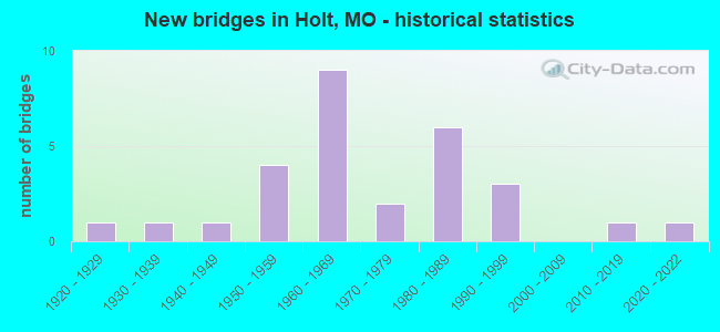
- New bridges - historical statistics
- 11920-1929
- 11930-1939
- 11940-1949
- 41950-1959
- 91960-1969
- 21970-1979
- 61980-1989
- 31990-1999
- 12010-2019
- 12020-2022
FCC Registered Antenna Towers:
15 (See the full list of FCC Registered Antenna Towers in Holt)FCC Registered Broadcast Land Mobile Towers:
5- 7521 Shoshone Drive (Lat: 39.460639 Lon: -94.322278), Type: Pole, Structure height: 54 m, Call Sign: WPKZ345,
Assigned Frequencies: 154.340 MHz, Grant Date: 11/15/2022, Expiration Date: 10/16/2032, Certifier: William R Moore, Registrant: Midwest Mobile Radio Service, Inc., 812 South 10th Street, Saint Joseph, MO 64501, Phone: (816) 279-2065, Fax: (816) 233-8862, Email:
- HOLT, .5km S Jct Hwy Pp & I35 W Side (Lat: 39.455833 Lon: -94.324250), Type: Tank, Structure height: 39.6 m, Overall height: 45.1 m, Call Sign: KWI701,
Assigned Frequencies: 155.835 MHz, Grant Date: 02/06/2021, Expiration Date: 02/12/2031, Registrant: Midwest Mobile Radio Service, Inc., 812 South 10th Street, Saint Joseph, MO 64501-3694, Phone: (816) 279-2065, Fax: (816) 233-8862, Email:
- Dead End Of Clay County Rd Just West Of I-35 (Lat: 39.455833 Lon: -94.324222), Type: Tank, Structure height: 30 m, Overall height: 33 m, Call Sign: KAG878,
Assigned Frequencies: 156.210 MHz, Grant Date: 01/10/2024, Expiration Date: 03/02/2034, Registrant: Public Safety Solutions Missouri, Springfield, MO 65801, Phone: (800) 605-8616, Email:
- WELL #5, 0.64mi Sse Of Ne 170th St & Sr33 Intersection (Lat: 39.391944 Lon: -94.367778), Type: Mast, Structure height: 9.1 m, Call Sign: WQJX778,
Assigned Frequencies: 451.162 MHz, Grant Date: 02/05/2009, Expiration Date: 02/05/2019, Cancellation Date: 04/13/2019, Certifier: Jan Mckay, Registrant: Micro-Comm, Inc., 15985 S. Pflumm Road, Olathe, KS 66062, Phone: (913) 390-4500, Fax: (913) 390-4550, Email:
- Lat: 39.456222 Lon: -94.338583, Call Sign: WRUN398,
Assigned Frequencies: 851.437 MHz, Grant Date: 09/14/2022, Expiration Date: 09/14/2032, Certifier: Robert L Looper, Registrant: Midwest Mobile Radio, 812 S 10th St, St Joseph, MO 64501, Phone: (816) 633-1025, Email:
FCC Registered Microwave Towers:
6- NE185, Lat: 39.429944 Lon: -94.382389, Type: Gtower, Structure height: 15.2 m, Overall height: 16.7 m, Call Sign: WQPS757,
Assigned Frequencies: 3650.00 MHz, Grant Date: 08/07/2012, Expiration Date: 08/07/2022, Cancellation Date: 08/22/2022, Certifier: Nyree D Howard, Registrant: Rural Farm Networks LLC, 7877 Se Troxler Ln, Lawson, MO 64062, Phone: (816) 841-2850, Email:
- A5C0053A, 6818 S.E. Haynesville Road (A5c0053a) (Lat: 39.475583 Lon: -94.307583), Type: Ltower, Structure height: 43 m, Call Sign: WQQC428, Licensee ID: L00127664,
Assigned Frequencies: 11525.0 MHz, 11565.0 MHz, 11525.0 MHz, 11565.0 MHz, 11525.0 MHz, 11565.0 MHz, 11525.0 MHz, 11565.0 MHz, 11525.0 MHz, 11565.0 MHz... (+4 more), Grant Date: 10/24/2012, Expiration Date: 10/24/2022, Cancellation Date: 04/01/2014, Certifier: Dan Menser, Registrant: T-Mobile License LLC, 12920 Se 38th Street, Bellevue, WA 98006, Phone: (425) 383-8401, Fax: (425) 383-4040, Email:
- TCCB, Lat: 39.417944 Lon: -94.340667, Type: Silo, Structure height: 30.5 m, Overall height: 32 m, Call Sign: WQQH894,
Assigned Frequencies: 3650.00 MHz, Grant Date: 12/18/2012, Expiration Date: 12/18/2022, Cancellation Date: 01/03/2023, Certifier: Kevin Smith, Registrant: Tiger Computer Consulting, LLC, 409 N Jefferson Suite A, Kearney, MO 64060, Phone: (816) 628-9063, Email:
- TCCG, Lat: 39.430278 Lon: -94.386056, Type: Ltower, Structure height: 18.3 m, Call Sign: WQQH894,
Assigned Frequencies: 3650.00 MHz, Grant Date: 12/18/2012, Expiration Date: 12/18/2022, Cancellation Date: 01/03/2023, Certifier: Kevin Smith, Registrant: Tiger Computer Consulting, LLC, 409 N Jefferson Suite A, Kearney, MO 64060, Phone: (816) 628-9063, Email:
- KC03XC243, 7521 Shoshone Drive (Lat: 39.460611 Lon: -94.322306), Type: Mtower, Structure height: 45.7 m, Call Sign: WQRA558,
Assigned Frequencies: 11225.0 MHz, 11345.0 MHz, 11225.0 MHz, 11345.0 MHz, 11225.0 MHz, 11345.0 MHz, 11225.0 MHz, 11345.0 MHz, 11225.0 MHz, 11345.0 MHz, 11225.0 MHz, 11345.0 MHz, Grant Date: 04/04/2013, Expiration Date: 04/04/2023, Cancellation Date: 03/30/2023, Certifier: David Werblow, Registrant: Dla Piper LLP, 500 8th Street, Nw, Washington, DC 20004, Phone: (202) 799-4216, Fax: (202) 799-5616, Email:
- A5C0053A, 6818 S.E. Haynesville Road (A5c0053a) (Lat: 39.475583 Lon: -94.307583), Type: Pole, Structure height: 43 m, Call Sign: WRUU411,
Assigned Frequencies: 11075.0 MHz, 11155.0 MHz, 11075.0 MHz, 11155.0 MHz, 11075.0 MHz, 11155.0 MHz, 11075.0 MHz, 11155.0 MHz, 11075.0 MHz, 11155.0 MHz... (+20 more), Grant Date: 10/04/2022, Expiration Date: 10/04/2032, Certifier: Jenny Knopf, Registrant: T-Mobile Usa, Inc., 12920 Se 38th Street, Bellevue, WA 98006, Phone: (425) 383-8401, Fax: (425) 383-4040, Email:
FCC Registered Amateur Radio Licenses:
35 (See the full list of FCC Registered Amateur Radio Licenses in Holt)FAA Registered Aircraft:
13 (See the full list of FAA Registered Aircraft in Holt)2002 - 2018 National Fire Incident Reporting System (NFIRS) incidents
- Fire incident types reported to NFIRS in Holt, MO
- 35859.6%Outside Fires
- 14724.5%Structure Fires
- 8814.6%Mobile Property/Vehicle Fires
- 81.3%Other
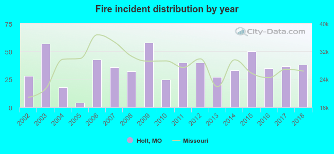 According to the data from the years 2002 - 2018 the average number of fires per year is 35. The highest number of reported fire incidents - 58 took place in 2009, and the least - 4 in 2005. The data has a rising trend.
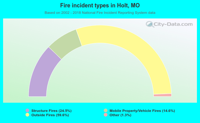 When looking into fire subcategories, the most incidents belonged to: Outside Fires (59.6%), and Structure Fires (24.5%).
| Most common first names in Holt, MO among deceased individuals | ||
| Name | Count | Lived (average) |
|---|---|---|
| William | 25 | 76.8 years |
| James | 15 | 69.3 years |
| Mary | 14 | 80.0 years |
| Richard | 10 | 66.1 years |
| Charles | 10 | 76.3 years |
| Dorothy | 9 | 79.0 years |
| John | 9 | 77.0 years |
| Robert | 8 | 71.9 years |
| Albert | 6 | 79.8 years |
| Nellie | 6 | 74.2 years |
| Most common last names in Holt, MO among deceased individuals | ||
| Last name | Count | Lived (average) |
|---|---|---|
| Wright | 10 | 89.0 years |
| Mick | 8 | 80.6 years |
| Anderson | 8 | 76.7 years |
| Porter | 7 | 84.5 years |
| Taylor | 5 | 88.2 years |
| Smith | 5 | 73.8 years |
| Bogart | 5 | 76.0 years |
| Calder | 5 | 76.6 years |
| Isley | 4 | 84.0 years |
| Moore | 4 | 79.5 years |
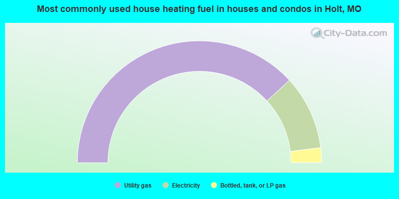
- 76.3%Utility gas
- 19.7%Electricity
- 3.9%Bottled, tank, or LP gas
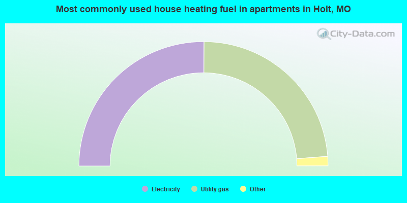
- 51.4%Electricity
- 48.6%Utility gas
Holt compared to Missouri state average:
- Black race population percentage significantly below state average.
- Foreign-born population percentage significantly below state average.
- Length of stay since moving in significantly above state average.
- Number of college students significantly below state average.
- Percentage of population with a bachelor's degree or higher below state average.

|
|
Total of 20 patent applications in 2008-2024.