Southeast Lyon, Kentucky
Submit your own pictures of this place and show them to the world
- OSM Map
- General Map
- Google Map
- MSN Map

| Males: 850 | |
| Females: 853 |
| Median resident age: | 47.5 years |
| Kentucky median age: | 35.9 years |
Zip code: 42038
| Southeast Lyon: | $63,611 |
| KY: | $59,341 |
Estimated per capita income in 2022: $32,129 (it was $16,673 in 2000)
Southeast Lyon CCD income, earnings, and wages data
Estimated median house or condo value in 2022: $213,742 (it was $85,500 in 2000)
| Southeast Lyon: | $213,742 |
| KY: | $196,300 |
Southeast Lyon, KY residents, houses, and apartments details
Detailed information about poverty and poor residents in Southeast Lyon, KY


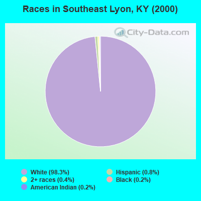
- 1,62998.3%White alone
- 140.8%Hispanic
- 60.4%Two or more races
- 30.2%Black alone
- 30.2%American Indian alone
- 10.06%Asian alone
- 10.06%Other race alone
Races in Southeast Lyon detailed stats: ancestries, foreign born residents, place of birth
 Recent articles from our blog. Our writers, many of them Ph.D. graduates or candidates, create easy-to-read articles on a wide variety of topics.
Current Local Time: CST time zone
Land area: 58.3 square miles.
Population density: 29 people per square mile (very low).

| Southeast Lyon CCD: | 0.6% ($531) |
| Kentucky: | 0.8% ($610) |
Nearest city with pop. 50,000+: Clarksville, TN  (47.1 miles , pop. 103,455).
Nearest city with pop. 200,000+: Metropolitan Government, TN (90.2 miles , pop. 569,891).
Nearest city with pop. 1,000,000+: Chicago, IL (334.9 miles , pop. 2,896,016).
Nearest cities:
), )Latitude: 37.01 N, Longitude: 88.00 W
Area code commonly used in this area: 270

| Here: | 4.0% |
| Kentucky: | 3.8% |
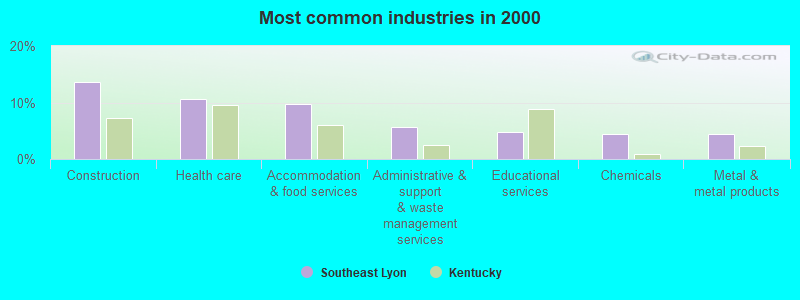
- Construction (13.7%)
- Health care (10.6%)
- Accommodation & food services (9.7%)
- Administrative & support & waste management services (5.6%)
- Educational services (4.7%)
- Chemicals (4.4%)
- Metal & metal products (4.4%)
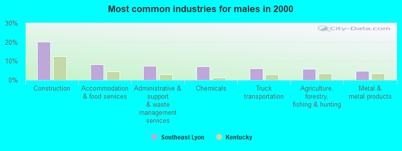
- Construction (20.3%)
- Accommodation & food services (8.2%)
- Administrative & support & waste management services (7.4%)
- Chemicals (7.2%)
- Truck transportation (6.2%)
- Agriculture, forestry, fishing & hunting (5.9%)
- Metal & metal products (4.7%)
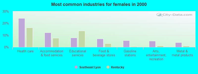
- Health care (24.3%)
- Accommodation & food services (12.2%)
- Educational services (7.8%)
- Food & beverage stores (7.1%)
- Gasoline stations (5.5%)
- Arts, entertainment, recreation (5.1%)
- Metal & metal products (3.9%)
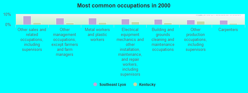
- Other sales and related occupations, including supervisors (8.3%)
- Other management occupations, except farmers and farm managers (6.4%)
- Metal workers and plastic workers (6.2%)
- Electrical equipment mechanics and other installation, maintenance, and repair workers, including supervisors (5.5%)
- Building and grounds cleaning and maintenance occupations (5.0%)
- Other production occupations, including supervisors (4.4%)
- Carpenters (4.2%)
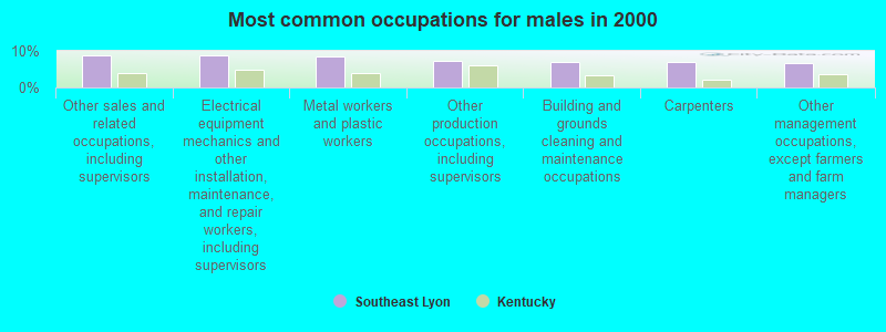
- Other sales and related occupations, including supervisors (8.9%)
- Electrical equipment mechanics and other installation, maintenance, and repair workers, including supervisors (8.9%)
- Metal workers and plastic workers (8.4%)
- Other production occupations, including supervisors (7.2%)
- Building and grounds cleaning and maintenance occupations (6.9%)
- Carpenters (6.9%)
- Other management occupations, except farmers and farm managers (6.7%)
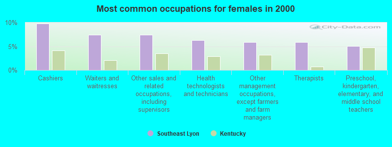
- Cashiers (9.8%)
- Waiters and waitresses (7.5%)
- Other sales and related occupations, including supervisors (7.5%)
- Health technologists and technicians (6.3%)
- Other management occupations, except farmers and farm managers (5.9%)
- Therapists (5.9%)
- Preschool, kindergarten, elementary, and middle school teachers (5.1%)
Average climate in Southeast Lyon, Kentucky
Based on data reported by over 4,000 weather stations


(lower is better)
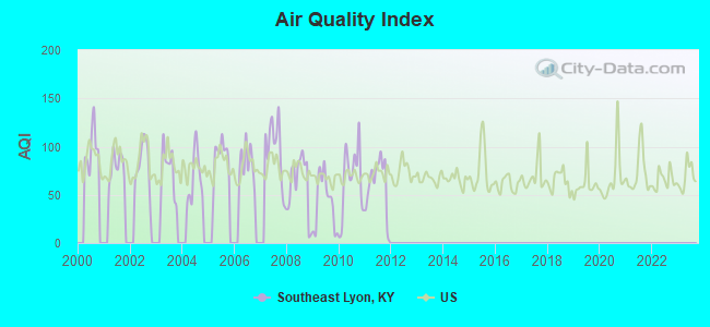
Air Quality Index (AQI) level in 2011 was 59.9. This is better than average.
| City: | 59.9 |
| U.S.: | 72.6 |
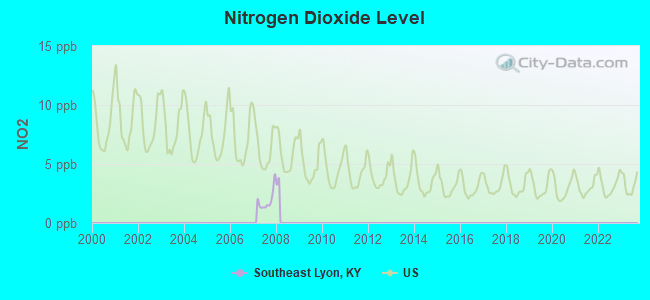
Nitrogen Dioxide (NO2) [ppb] level in 2007 was 1.91. This is significantly better than average. Closest monitor was 9.6 miles away from the city center.
| City: | 1.91 |
| U.S.: | 5.11 |
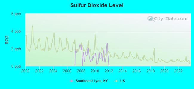
Sulfur Dioxide (SO2) [ppb] level in 2011 was 1.30. This is about average. Closest monitor was 9.6 miles away from the city center.
| City: | 1.30 |
| U.S.: | 1.51 |
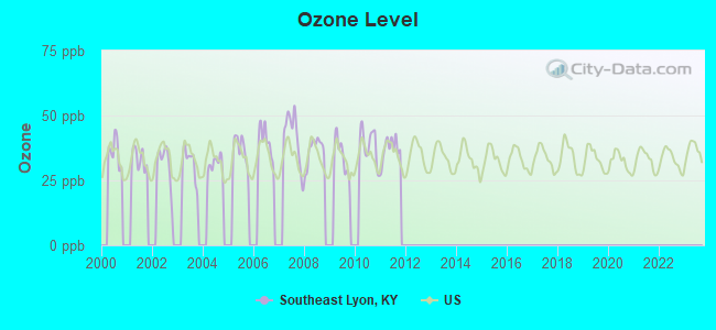
Ozone [ppb] level in 2011 was 37.2. This is about average. Closest monitor was 7.2 miles away from the city center.
| City: | 37.2 |
| U.S.: | 33.3 |
Tornado activity:
Southeast Lyon-area historical tornado activity is slightly above Kentucky state average. It is 59% greater than the overall U.S. average.
On 3/4/1964, a category F4 (max. wind speeds 207-260 mph) tornado 14.0 miles away from the Southeast Lyon place center killed 3 people and injured 24 people and caused between $50,000 and $500,000 in damages.
On 4/3/1968, a category F4 tornado 21.9 miles away from the place center killed 2 people and injured 30 people and caused between $500,000 and $5,000,000 in damages.
Earthquake activity:
Southeast Lyon-area historical earthquake activity is significantly above Kentucky state average. It is 268% greater than the overall U.S. average.On 4/18/2008 at 09:36:59, a magnitude 5.4 (5.1 MB, 4.8 MS, 5.4 MW, 5.2 MW, Class: Moderate, Intensity: VI - VII) earthquake occurred 100.3 miles away from the city center
On 4/18/2008 at 09:36:59, a magnitude 5.2 (5.2 MW, Depth: 8.9 mi) earthquake occurred 100.2 miles away from Southeast Lyon center
On 6/18/2002 at 17:37:15, a magnitude 5.0 (4.3 MB, 4.6 MW, 5.0 LG) earthquake occurred 69.0 miles away from the city center
On 9/26/1990 at 13:18:51, a magnitude 5.0 (4.7 MB, 4.8 LG, 5.0 LG, Depth: 7.7 mi) earthquake occurred 85.4 miles away from Southeast Lyon center
On 6/10/1987 at 23:48:54, a magnitude 5.1 (4.9 MB, 4.4 MS, 4.6 MS, 5.1 LG) earthquake occurred 125.8 miles away from the city center
On 5/4/1991 at 01:18:54, a magnitude 5.0 (4.4 MB, 4.6 LG, 5.0 LG, Depth: 3.1 mi) earthquake occurred 105.5 miles away from the city center
Magnitude types: regional Lg-wave magnitude (LG), body-wave magnitude (MB), surface-wave magnitude (MS), moment magnitude (MW)
Natural disasters:
The number of natural disasters in Lyon County (11) is smaller than the US average (15).Major Disasters (Presidential) Declared: 8
Emergencies Declared: 2
Causes of natural disasters: Floods: 5, Storms: 4, Winter Storms: 4, Mudslides: 2, Tornadoes: 2, Blizzard: 1, Hurricane: 1, Landslide: 1, Snow: 1, Snowstorm: 1, Tropical Depression: 1, Wind: 1, Other: 1 (Note: some incidents may be assigned to more than one category).
Hospitals and medical centers near Southeast Lyon:
- FMC - KUTTAWA DIALYSIS (Dialysis Facility, about 5 miles away; KUTTAWA, KY)
- CHRISTIAN CARE CENTER OF KUTTAWA, LLC (Nursing Home, about 8 miles away; KUTTAWA, KY)
- RIVER'S BEND RETIREMENT COMMUNITY (Nursing Home, about 9 miles away; KUTTAWA, KY)
- CALDWELL COUNTY DIALYSIS (Dialysis Facility, about 10 miles away; PRINCETON, KY)
- PRINCETON HEALTH AND REHAB CENTER, INC (Nursing Home, about 10 miles away; PRINCETON, KY)
- PRINCETON HEALTH CARE MANOR (Nursing Home, about 10 miles away; PRINCETON, KY)
- SHADY LAWN NURSING AND REHABILITATION CENTER (Nursing Home, about 14 miles away; CADIZ, KY)
Colleges/universities with over 2000 students nearest to Southeast Lyon:
- Hopkinsville Community College (about 30 miles; Hopkinsville, KY; Full-time enrollment: 2,269)
- Murray State University (about 33 miles; Murray, KY; FT enrollment: 8,930)
- West Kentucky Community and Technical College (about 37 miles; Paducah, KY; FT enrollment: 4,107)
- Madisonville Community College (about 37 miles; Madisonville, KY; FT enrollment: 2,082)
- Austin Peay State University (about 49 miles; Clarksville, TN; FT enrollment: 8,621)
- Bethel University (about 67 miles; McKenzie, TN; FT enrollment: 5,878)
- The University of Tennessee-Martin (about 67 miles; Martin, TN; FT enrollment: 7,013)
Points of interest:
Notable locations in Southeast Lyon: Holiday Hills Camp (A), Tinsley Creek Bay (B), Sky Pilot Harbor (C). Display/hide their locations on the map
Churches in Southeast Lyon include: Friendship Church (A), Liberty Church (B), Pleasant Hill Church (C), Bethany Missionary Baptist Church (D). Display/hide their locations on the map
Cemeteries: Confederate Cemetery (1), Parker Cemetery (2), Steinbaugh Cemetery (3), Dry Fork Cemetery (4), Oliver Cemetery (5), Freeman-Cash Cemetery (6), Gray Cemetery (7). Display/hide their locations on the map
Reservoir: Hawkins Lake (A). Display/hide its location on the map
Streams, rivers, and creeks: Bells Creek (A), Confederate Branch (B), Tinsley Creek (C), Sweetwater Creek (D), Pilfer Creek (E), Buzzard Creek (F), South Fork Dryden Creek (G), McNabb Creek (H), Motley Creek (I). Display/hide their locations on the map
Parks in Southeast Lyon include: Cannon Spring Public Use Area (1), Eddy Creek Recreational Area (2). Display/hide their locations on the map
| This place: | 2.2 people |
| Kentucky: | 2.5 people |
| This place: | 70.8% |
| Whole state: | 66.9% |
| This place: | 4.7% |
| Whole state: | 6.4% |
Likely homosexual households (counted as self-reported same-sex unmarried-partner households)
- Lesbian couples: 0.5% of all households
- Gay men: 0.5% of all households
| This place: | 14.6% |
| Whole state: | 15.8% |
| This place: | 3.1% |
| Whole state: | 6.6% |
For population 15 years and over in Southeast Lyon:
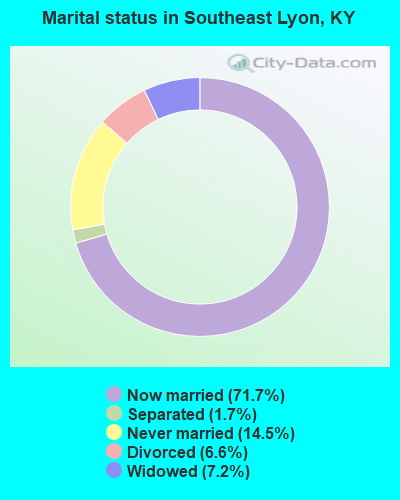
- Never married: 14.5%
- Now married: 71.7%
- Separated: 1.7%
- Widowed: 7.2%
- Divorced: 6.6%
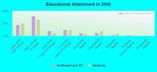
For population 25 years and over in Southeast Lyon:
- High school or higher: 77.8%
- Bachelor's degree or higher: 10.3%
- Graduate or professional degree: 3.9%
- Unemployed: 5.0%
- Mean travel time to work (commute): 25.3 minutes
| Here: | 10.2 |
| Kentucky average: | 13.8 |
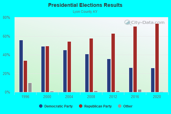
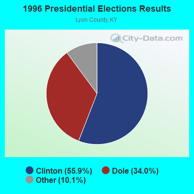
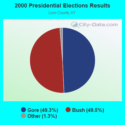
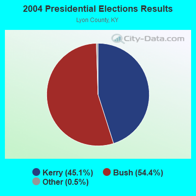
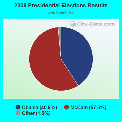
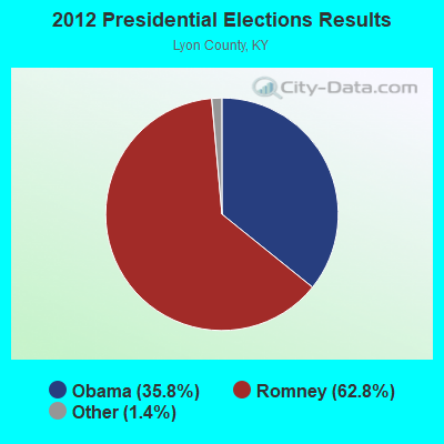
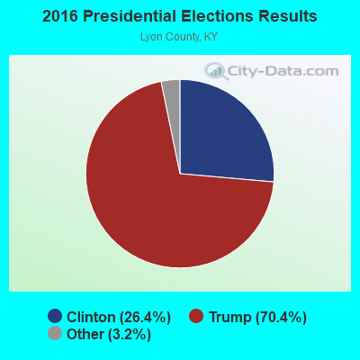
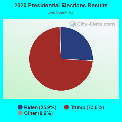
Graphs represent county-level data. Detailed 2008 Election Results
Religion statistics for Southeast Lyon, KY (based on Lyon County data)
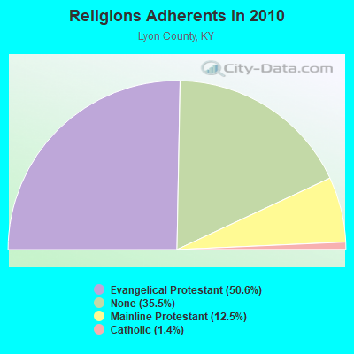
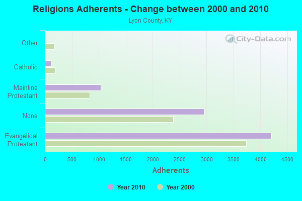
| Religion | Adherents | Congregations |
|---|---|---|
| Evangelical Protestant | 4,209 | 21 |
| Mainline Protestant | 1,041 | 6 |
| Catholic | 113 | 1 |
| Other | 1 | - |
| None | 2,950 | - |
Food Environment Statistics:
| Here: | 1.21 / 10,000 pop. |
| Kentucky: | 2.19 / 10,000 pop. |
| Lyon County: | 1.21 / 10,000 pop. |
| Kentucky: | 0.74 / 10,000 pop. |
| This county: | 4.85 / 10,000 pop. |
| Kentucky: | 4.36 / 10,000 pop. |
| Lyon County: | 9.70 / 10,000 pop. |
| Kentucky: | 5.74 / 10,000 pop. |
| Lyon County: | 11.8% |
| Kentucky: | 11.0% |
| Lyon County: | 32.0% |
| Kentucky: | 30.0% |
| Here: | 19.8% |
| Kentucky: | 15.9% |
Strongest AM radio stations in Southeast Lyon:
- WWLK (900 AM; 1 kW; EDDYVILLE, KY; Owner: TILENT, INC.)
- WCBL (1290 AM; 5 kW; BENTON, KY; Owner: JIM W. FREELAND)
- WSM (650 AM; 50 kW; NASHVILLE, TN; Owner: GAYLORD ENTERTAINMENT COMPANY)
- WKDA (1200 AM; 50 kW; NASHVILLE, TN; Owner: RADIO NASHVILLE, INC.)
- WPAD (1560 AM; 10 kW; PADUCAH, KY; Owner: BRISTOL BROADCASTING COMPANY, INC.)
- WNQM (1300 AM; 50 kW; NASHVILLE, TN; Owner: WNQM. INC.)
- WAMB (1160 AM; 50 kW; DONELSON, TN; Owner: GREAT SOUTHERN BROADCASTING COMPANY, INC.)
- WKDZ (1110 AM; daytime; 1 kW; CADIZ, KY; Owner: HAM BROADCASTING COMPANY, INC.)
- WLAC (1510 AM; 50 kW; NASHVILLE, TN; Owner: CAPSTAR TX LIMITED PARTNERSHIP)
- WCRV (640 AM; 50 kW; COLLIERVILLE, TN; Owner: BOTT BROADCASTING COMPANY/TENNESSEE)
- WRKY (1130 AM; 2 kW; MURRAY, KY; Owner: FOREVER COMMUNICATIONS INC)
- WDDD (810 AM; 10 kW; JOHNSTON CITY, IL; Owner: CLEAR CHANNEL BROADCASTING LICENSES, INC.)
- WHAS (840 AM; 50 kW; LOUISVILLE, KY; Owner: CLEAR CHANNEL BROADCASTING LICENSES, INC.)
Strongest FM radio stations in Southeast Lyon:
- WVVR (100.3 FM; HOPKINSVILLE, KY; Owner: SAGA COMMUNICATIONS OF TUCKESSEE, LLC)
- WCCK (95.7 FM; CALVERT CITY, KY; Owner: JIM W. FREELAND DBA FREELAND BROADCASTING)
- WKYQ (93.3 FM; PADUCAH, KY; Owner: BRISTOL BROADCASTING COMPANY, INC.)
- WCVQ (107.9 FM; FORT CAMPBELL, KY; Owner: SAGA COMMUNICATIONS OF TUCKESSEE, LLC)
- WVHM (90.5 FM; BENTON, KY; Owner: HEARTLAND MINISTRIES, INC.)
- WDDJ (96.9 FM; PADUCAH, KY; Owner: BRISTOL BROADCASTING COMPANY, INC.)
- WAVJ (104.9 FM; PRINCETON, KY; Owner: CALDWELL COUNTY CBC, INC.)
- WKDZ-FM (106.5 FM; CADIZ, KY; Owner: HAM BROADCASTING COMPANY, INC.)
- WAAJ (89.7 FM; BENTON, KY; Owner: HEARTLAND MINISTRIES, INC.)
- WKMS-FM (91.3 FM; MURRAY, KY; Owner: MURRAY STATE UNIVERSITY)
- WRIK-FM (98.3 FM; METROPOLIS, IL; Owner: SUN MEDIA, INC.)
- WCBL-FM (99.1 FM; BENTON, KY; Owner: JIM W. FREELAND)
- WMJL-FM (102.7 FM; MARION, KY; Owner: JOEMYERS PRODUCTIONS, INC.)
TV broadcast stations around Southeast Lyon:
- WKMA-TV (Channel 35; MADISONVILLE, KY; Owner: KENTUCKY AUTHORITY FOR EDUCATIONAL TV)
- WDKA (Channel 49; PADUCAH, KY; Owner: WDKA ACQUISITION CORPORATION)
- WPSD-TV (Channel 6; PADUCAH, KY; Owner: WPSD-TV, LLC)
- WAZE-TV (Channel 19; MADISONVILLE, KY; Owner: SOUTH CENTRAL COMMUNICATIONS CORP.)
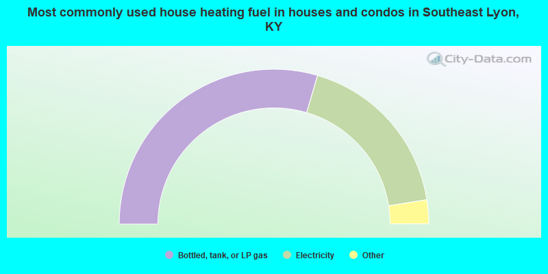
- 59.1%Bottled, tank, or LP gas
- 35.9%Electricity
- 3.9%Wood
- 1.1%Utility gas
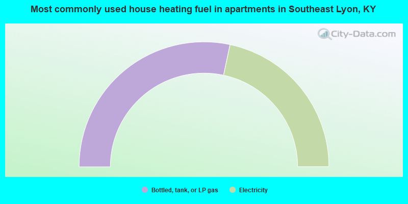
- 56.7%Bottled, tank, or LP gas
- 43.3%Electricity
Southeast Lyon compared to Kentucky state average:
- Unemployed percentage significantly below state average.
- Black race population percentage significantly below state average.
- Hispanic race population percentage significantly below state average.
- Median age above state average.
- Foreign-born population percentage significantly below state average.
- Renting percentage significantly below state average.
- Length of stay since moving in significantly above state average.
- Number of rooms per house significantly below state average.
- House age significantly below state average.
- Number of college students below state average.
- Percentage of population with a bachelor's degree or higher below state average.