Swampscott, Massachusetts
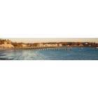
Swampscott: Fisherman's Beach Swampscott, MA
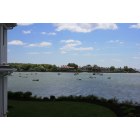
Swampscott: Swampscott Harbor
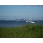
Swampscott: Boston Skyline from Fisherman's Beach
Swampscott: Fisherman's Beach
Swampscott: Fisherman's Beach
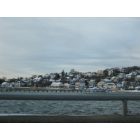
Swampscott: Swampscott Winter
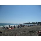
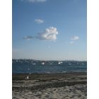
Swampscott: Phillips Beach - Swampscott
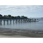
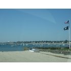
Swampscott: Swampscott Pier
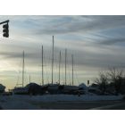
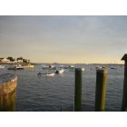
Swampscott: Swampscott Sailboats
Swampscott: Warf at Swampscott, MA
- add
your
Submit your own pictures of this place and show them to the world
- OSM Map
- General Map
- Google Map
- MSN Map
Population change since 2000: -4.3%
| Males: 6,504 | |
| Females: 7,283 |
| Median resident age: | 45.6 years |
| Massachusetts median age: | 40.3 years |
Zip codes: 01907.
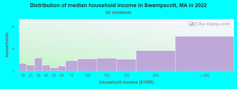
| Swampscott: | $116,176 |
| MA: | $94,488 |
Estimated per capita income in 2022: $72,959 (it was $35,487 in 2000)
Swampscott CDP income, earnings, and wages data
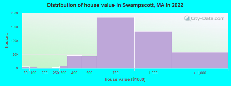
Estimated median house or condo value in 2022: $700,584 (it was $266,000 in 2000)
| Swampscott: | $700,584 |
| MA: | $534,700 |
Mean prices in 2022: all housing units: $768,503; detached houses: $881,421; townhouses or other attached units: $586,082; in 2-unit structures: $539,157; in 3-to-4-unit structures: $399,230; in 5-or-more-unit structures: $336,487
Median gross rent in 2022: $2,287.
(5.4% for White Non-Hispanic residents, 35.6% for Black residents, 6.6% for Hispanic or Latino residents, 43.9% for American Indian residents, 63.4% for other race residents)
Detailed information about poverty and poor residents in Swampscott, MA

Compare current foreclosures near Swampscott, MA:
| Photo | Address | Area | Beds / Baths | Price | Details |
|---|---|---|---|---|---|

|
#1
Essex St
Swampscott, MA 01907
|
2,029 sq. feet
|
2 baths 3 beds |
show details | |

|
#2
The Greenway
Swampscott, MA 01907
|
1,245 sq. feet
|
1 baths 2 beds |
show details | |

|
#3
Puritan Rd
Swampscott, MA 01907
|
2,373 sq. feet
|
3 baths 3 beds |
show details | |

|
#4
Essex St # 89-91
Swampscott, MA 01907
|
2,029 sq. feet
|
2 baths 3 beds |
show details | |

|
#5
Essex S 2
Swampscott, MA 01907
|
2,029 sq. feet
|
2 baths 3 beds |
show details | |

|
#6
Pine St # 1
Swampscott, MA 01907
|
- sq. feet
|
- baths - beds |
show details | |

|
#7
Paradise Rd
Swampscott, MA 01907
|
- sq. feet
|
- baths - beds |
show details | |

|
#8
Humphrey St # 5
Swampscott, MA 01907
|
- sq. feet
|
- baths - beds |
show details | |

|
#9
Paradise Rd Apt 4g
Swampscott, MA 01907
|
- sq. feet
|
- baths - beds |
show details | |

|
#10
Park Ave Apt 614
Hull, MA 02045
|
1,109 sq. feet
|
2 baths 2 beds |
$350,000
|
show details |
| Photo | Address | Area | Beds / Baths | Price | Details |
|---|---|---|---|---|---|

|
#11
Johnson Rd
North Weymouth, MA 02191
|
748 sq. feet
|
1 baths 2 beds |
$365,000
|
show details |

|
#12
Porrazzo Rd # 2
Hull, MA 02045
|
1,203 sq. feet
|
2 baths 2 beds |
$329,900
|
show details |

|
#13
Commonwealth Ave Apt B
Boston, MA 02116
|
- sq. feet
|
1 baths 2 beds |
$684,900
|
show details |

|
#14
Portland St
Lynn, MA 01902
|
851 sq. feet
|
2 baths 2 beds |
show details | |

|
#15
Church St
Boston, MA 02122
|
3,663 sq. feet
|
3 baths 6 beds |
show details | |

|
#16
Bloomfield St
Boston, MA 02124
|
2,667 sq. feet
|
2 baths 6 beds |
show details | |

|
#17
Chase St
Beverly, MA 01915
|
1,407 sq. feet
|
1 baths 3 beds |
show details | |

|
#18
Gordon St
Allston, MA 02134
|
3,246 sq. feet
|
2 baths 5 beds |
show details | |

|
#19
Cora St
Winthrop, MA 02152
|
1,452 sq. feet
|
1 baths 2 beds |
show details | |

|
#20
Magnolia St
Boston, MA 02125
|
3,654 sq. feet
|
3 baths 6 beds |
show details |
| Photo | Address | Area | Beds / Baths | Price | Details |
|---|---|---|---|---|---|

|
#21
Marden Ave # 6
Boston, MA 02124
|
1,639 sq. feet
|
1 baths 3 beds |
show details | |

|
#22
Lincoln Ave
Saugus, MA 01906
|
1,080 sq. feet
|
1 baths 3 beds |
show details | |

|
#23
Hadley St # 2
Medford, MA 02155
|
1,866 sq. feet
|
1 baths 3 beds |
show details | |

|
#24
Forest Park Rd
Woburn, MA 01801
|
1,132 sq. feet
|
1 baths 3 beds |
show details | |

|
#25
Margin Street
Lynn, MA 01905
|
1,240 sq. feet
|
2 baths 2 beds |
show details | |

|
#26
Gay St
Quincy, MA 02169
|
1,330 sq. feet
|
1 baths 4 beds |
show details | |

|
#27
Naugus Ave
Marblehead, MA 01945
|
1,544 sq. feet
|
1 baths 3 beds |
show details | |

|
#28
Ballou St
Quincy, MA 02169
|
1,758 sq. feet
|
1 baths 3 beds |
show details | |

|
#29
Iroquois St
Boston, MA 02120
|
2,524 sq. feet
|
1 baths 4 beds |
show details | |

|
#30
Merrill Ave
Lynn, MA 01902
|
1,136 sq. feet
|
1 baths 3 beds |
show details |
| Photo | Address | Area | Beds / Baths | Price | Details |
|---|---|---|---|---|---|

|
#31
Emily Rd
Tewksbury, MA 01876
|
1,600 sq. feet
|
1 baths 3 beds |
show details | |

|
#32
Atlantic Street, Unit A 10 A/k/a Unit 10, Marilyn Condominium
Lynn, MA 01902
|
576 sq. feet
|
1 baths 1 beds |
show details | |

|
#33
Quincy St
Boston, MA 02121
|
1,826 sq. feet
|
3 baths 8 beds |
show details | |

|
#34
Foley Farm Rd
Wilmington, MA 01887
|
2,516 sq. feet
|
3 baths 4 beds |
show details | |

|
#35
Fayerweather St
Cambridge, MA 02138
|
2,791 sq. feet
|
2 baths 5 beds |
show details | |

|
#36
Richfield St
Quincy, MA 02171
|
1,368 sq. feet
|
1 baths 3 beds |
show details | |

|
#37
John Wise Ave
Essex, MA 01929
|
4,597 sq. feet
|
3 baths 4 beds |
show details | |

|
#38
Cunard St
Boston, MA 02120
|
3,216 sq. feet
|
3 baths 6 beds |
show details | |

|
#39
Cunard St
Boston, MA 02120
|
3,216 sq. feet
|
3 baths 6 beds |
show details | |

|
#40
Burlington St
Woburn, MA 01801
|
1,008 sq. feet
|
2 baths 5 beds |
show details |
| Photo | Address | Area | Beds / Baths | Price | Details |
|---|---|---|---|---|---|

|
#41
Lord Ter
Woburn, MA 01801
|
1,008 sq. feet
|
1 baths 3 beds |
show details | |

|
#42
Shirley Ave
North Reading, MA 01864
|
1,236 sq. feet
|
2 baths 4 beds |
show details | |

|
#43
Newcomb St Apt 7
Boston, MA 02118
|
1,177 sq. feet
|
1 baths 1 beds |
show details | |

|
#44
Gaston St
Boston, MA 02121
|
2,743 sq. feet
|
3 baths 5 beds |
show details | |

|
#45
Baker Ct # 4
Boston, MA 02125
|
966 sq. feet
|
1 baths 3 beds |
show details | |

|
#46
North St
North Reading, MA 01864
|
2,602 sq. feet
|
2 baths 4 beds |
show details | |

|
#47
Western Ave
Cambridge, MA 02139
|
914 sq. feet
|
1 baths 1 beds |
show details | |

|
#48
Hanson Rd
Wilmington, MA 01887
|
1,044 sq. feet
|
1 baths 3 beds |
show details | |

|
#49
Batchelder St
Boston, MA 02125
|
1,637 sq. feet
|
2 baths 5 beds |
show details | |

|
Check over 1 million property listings on Foreclosure.com!
|
browse all offers | |||


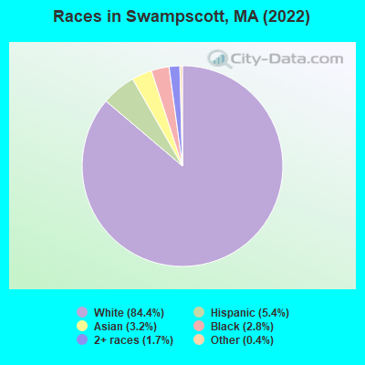
- 12,77184.4%White alone
- 8185.4%Hispanic
- 4773.2%Asian alone
- 4202.8%Black alone
- 2501.7%Two or more races
- 650.4%Other race alone
Races in Swampscott detailed stats: ancestries, foreign born residents, place of birth
According to our research of Massachusetts and other state lists, there were 3 registered sex offenders living in Swampscott, Massachusetts as of April 28, 2024.
The ratio of all residents to sex offenders in Swampscott is 4,809 to 1.
The ratio of registered sex offenders to all residents in this city is much lower than the state average.
Type |
2009 |
2010 |
2011 |
2012 |
2013 |
2014 |
2015 |
2016 |
2017 |
2018 |
2019 |
2020 |
2021 |
2022 |
|---|---|---|---|---|---|---|---|---|---|---|---|---|---|---|
| Murders (per 100,000) | 0 (0.0) | 0 (0.0) | 0 (0.0) | 0 (0.0) | 0 (0.0) | 0 (0.0) | 0 (0.0) | 0 (0.0) | 0 (0.0) | 0 (0.0) | 0 (0.0) | 0 (0.0) | 0 (0.0) | 0 (0.0) |
| Rapes (per 100,000) | 1 (7.1) | 0 (0.0) | 0 (0.0) | 0 (0.0) | 1 (7.1) | 1 (7.1) | 1 (7.1) | 2 (13.7) | 2 (13.3) | 3 (19.5) | 1 (6.5) | 0 (0.0) | 0 (0.0) | 0 (0.0) |
| Robberies (per 100,000) | 4 (28.3) | 4 (29.0) | 3 (21.6) | 6 (42.8) | 5 (35.7) | 3 (21.4) | 1 (7.1) | 0 (0.0) | 1 (6.7) | 1 (6.5) | 1 (6.5) | 3 (19.5) | 2 (12.7) | 2 (13.1) |
| Assaults (per 100,000) | 16 (113.4) | 15 (108.8) | 9 (64.9) | 7 (49.9) | 20 (142.9) | 14 (99.8) | 16 (113.7) | 8 (55.0) | 11 (73.3) | 5 (32.5) | 6 (39.2) | 17 (110.5) | 4 (25.4) | 10 (65.5) |
| Burglaries (per 100,000) | 34 (240.9) | 44 (319.1) | 42 (302.8) | 31 (221.1) | 58 (414.4) | 36 (256.6) | 35 (248.7) | 26 (178.7) | 17 (113.2) | 25 (162.5) | 12 (78.5) | 9 (58.5) | 12 (76.1) | 14 (91.7) |
| Thefts (per 100,000) | 235 (1,665) | 215 (1,559) | 155 (1,117) | 202 (1,441) | 204 (1,458) | 205 (1,461) | 194 (1,379) | 154 (1,058) | 159 (1,059) | 138 (897.3) | 100 (653.8) | 125 (812.2) | 94 (596.2) | 116 (759.8) |
| Auto thefts (per 100,000) | 10 (70.9) | 9 (65.3) | 6 (43.3) | 4 (28.5) | 4 (28.6) | 8 (57.0) | 5 (35.5) | 6 (41.2) | 5 (33.3) | 7 (45.5) | 1 (6.5) | 4 (26.0) | 4 (25.4) | 2 (13.1) |
| Arson (per 100,000) | 0 (0.0) | 1 (7.3) | 1 (7.2) | 1 (7.1) | 0 (0.0) | 0 (0.0) | 0 (0.0) | 5 (34.4) | 0 (0.0) | 0 (0.0) | 0 (0.0) | 0 (0.0) | 1 (6.3) | 0 (0.0) |
| City-Data.com crime index | 126.0 | 120.4 | 88.8 | 98.2 | 134.6 | 113.1 | 106.0 | 80.1 | 80.2 | 75.0 | 47.2 | 66.6 | 40.1 | 54.9 |
The City-Data.com crime index weighs serious crimes and violent crimes more heavily. Higher means more crime, U.S. average is 246.1. It adjusts for the number of visitors and daily workers commuting into cities.
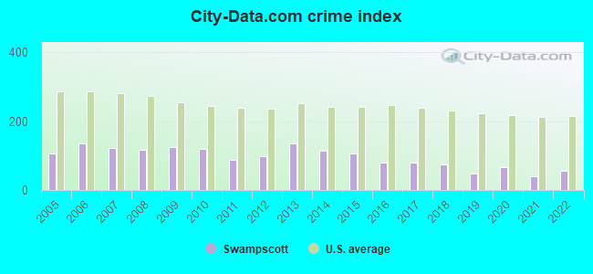
Crime rate in Swampscott detailed stats: murders, rapes, robberies, assaults, burglaries, thefts, arson
Full-time law enforcement employees in 2021, including police officers: 30 (29 officers - 28 male; 1 female).
| Officers per 1,000 residents here: | 1.84 |
| Massachusetts average: | 2.53 |
 Recent articles from our blog. Our writers, many of them Ph.D. graduates or candidates, create easy-to-read articles on a wide variety of topics.

 | Why is Boston so famous for its racism?! (1466 replies) |
| Marblehead/Swampscott commute to Kendall Sq. Cambridge (22 replies) |
| Swampscott Commuter Rail Station (9 replies) |
| Like Swampscott, but somewhere else? (12 replies) |
| How safe is the Swampscott side of the Lynn/Swampscott line? (3 replies) |
| Swampscott: The most beautiful mismanaged town in MA! (25 replies) |
Latest news from Swampscott, MA collected exclusively by city-data.com from local newspapers, TV, and radio stations
Ancestries: Irish (8.9%), Russian (8.7%), Italian (7.5%), Armenian (6.8%), English (4.5%), American (3.6%).
Current Local Time: EST time zone
Incorporated in 1852
Elevation: 45 feet
Land area: 3.05 square miles.
Population density: 4,521 people per square mile (average).
3,090 residents are foreign born (8.9% Europe, 5.8% Asia, 3.5% Latin America).
| This place: | 20.4% |
| Massachusetts: | 17.6% |
Median real estate property taxes paid for housing units with mortgages in 2022: $7,990 (1.1%)
Median real estate property taxes paid for housing units with no mortgage in 2022: $7,369 (1.1%)
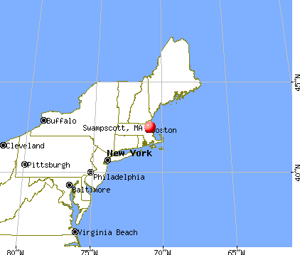
Nearest city with pop. 50,000+: Lynn, MA  (2.5 miles , pop. 89,050).
Nearest city with pop. 200,000+: Boston, MA (14.1 miles , pop. 589,141).
Nearest city with pop. 1,000,000+: Bronx, NY (190.2 miles , pop. 1,332,650).
Nearest cities:
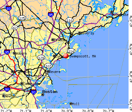
), Latitude: 42.47 N, Longitude: 70.91 W
Daytime population change due to commuting: -3,315 (-21.9%)
Workers who live and work in this place: 2,647 (32.1%)
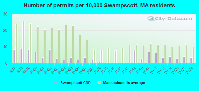
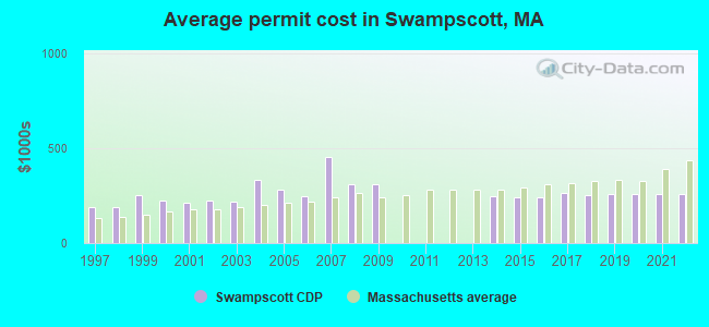
Single-family new house construction building permits:
- 2022: 5 buildings, average cost: $258,700
- 2021: 6 buildings, average cost: $258,700
- 2020: 4 buildings, average cost: $258,600
- 2019: 6 buildings, average cost: $259,400
- 2018: 5 buildings, average cost: $256,200
- 2017: 9 buildings, average cost: $265,700
- 2016: 10 buildings, average cost: $242,100
- 2015: 4 buildings, average cost: $241,600
- 2014: 11 buildings, average cost: $244,700
- 2009: 1 building, cost: $309,300
- 2008: 3 buildings, average cost: $309,300
- 2007: 5 buildings, average cost: $453,000
- 2006: 3 buildings, average cost: $249,300
- 2005: 5 buildings, average cost: $284,000
- 2004: 3 buildings, average cost: $332,700
- 2003: 4 buildings, average cost: $215,600
- 2002: 12 buildings, average cost: $224,700
- 2001: 5 buildings, average cost: $212,000
- 2000: 10 buildings, average cost: $225,300
- 1999: 12 buildings, average cost: $251,600
- 1998: 13 buildings, average cost: $187,700
- 1997: 12 buildings, average cost: $187,800
| Here: | 3.6% |
| Massachusetts: | 3.5% |
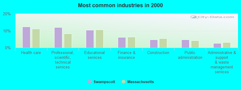
- Health care (12.3%)
- Professional, scientific, technical services (12.0%)
- Educational services (10.5%)
- Finance & insurance (6.2%)
- Construction (4.8%)
- Public administration (4.8%)
- Administrative & support & waste management services (2.7%)
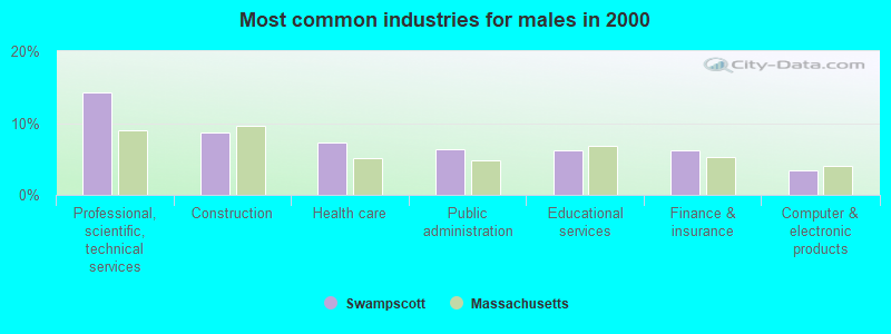
- Professional, scientific, technical services (14.3%)
- Construction (8.6%)
- Health care (7.3%)
- Public administration (6.3%)
- Educational services (6.3%)
- Finance & insurance (6.2%)
- Computer & electronic products (3.5%)
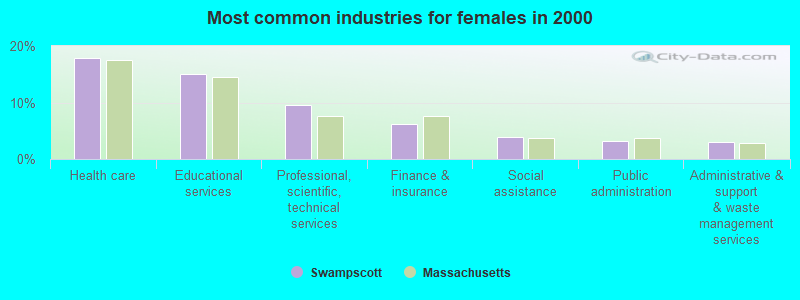
- Health care (17.8%)
- Educational services (15.1%)
- Professional, scientific, technical services (9.5%)
- Finance & insurance (6.3%)
- Social assistance (3.9%)
- Public administration (3.2%)
- Administrative & support & waste management services (3.1%)

- Other management occupations, except farmers and farm managers (5.9%)
- Computer specialists (4.0%)
- Other sales and related occupations, including supervisors (4.0%)
- Retail sales workers, except cashiers (3.9%)
- Preschool, kindergarten, elementary, and middle school teachers (3.7%)
- Secretaries and administrative assistants (3.6%)
- Sales representatives, services, wholesale and manufacturing (3.6%)
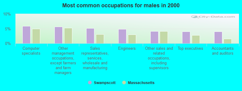
- Computer specialists (5.9%)
- Other management occupations, except farmers and farm managers (5.7%)
- Sales representatives, services, wholesale and manufacturing (5.2%)
- Engineers (4.9%)
- Other sales and related occupations, including supervisors (4.1%)
- Top executives (4.0%)
- Accountants and auditors (4.0%)

- Secretaries and administrative assistants (7.4%)
- Preschool, kindergarten, elementary, and middle school teachers (7.2%)
- Other management occupations, except farmers and farm managers (6.1%)
- Registered nurses (5.2%)
- Retail sales workers, except cashiers (4.5%)
- Other office and administrative support workers, including supervisors (4.4%)
- Information and record clerks, except customer service representatives (4.1%)
Average climate in Swampscott, Massachusetts
Based on data reported by over 4,000 weather stations


|
|


(lower is better)
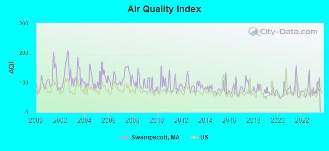
Air Quality Index (AQI) level in 2022 was 74.3. This is about average.
| City: | 74.3 |
| U.S.: | 72.6 |
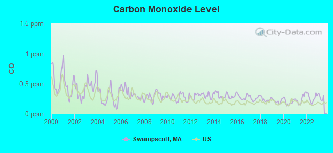
Carbon Monoxide (CO) [ppm] level in 2022 was 0.269. This is about average. Closest monitor was 9.1 miles away from the city center.
| City: | 0.269 |
| U.S.: | 0.251 |
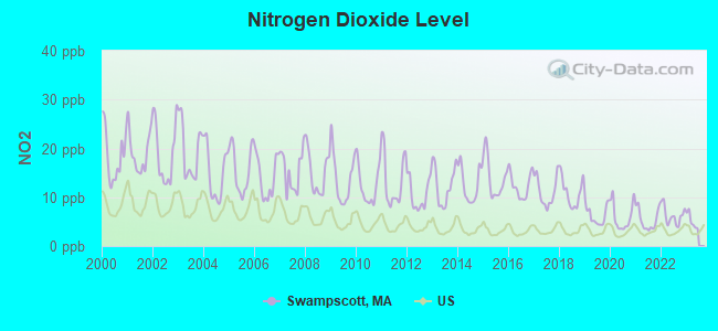
Nitrogen Dioxide (NO2) [ppb] level in 2022 was 6.24. This is worse than average. Closest monitor was 2.3 miles away from the city center.
| City: | 6.24 |
| U.S.: | 5.11 |
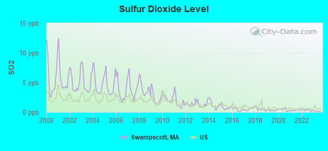
Sulfur Dioxide (SO2) [ppb] level in 2022 was 0.358. This is significantly better than average. Closest monitor was 2.3 miles away from the city center.
| City: | 0.358 |
| U.S.: | 1.515 |
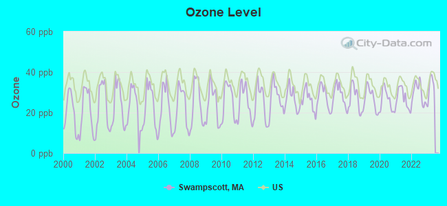
Ozone [ppb] level in 2022 was 29.5. This is about average. Closest monitor was 2.4 miles away from the city center.
| City: | 29.5 |
| U.S.: | 33.3 |
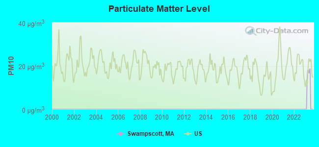
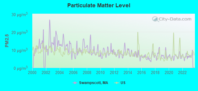
Particulate Matter (PM2.5) [µg/m3] level in 2022 was 6.24. This is better than average. Closest monitor was 3.3 miles away from the city center.
| City: | 6.24 |
| U.S.: | 8.11 |
Tornado activity:
Swampscott-area historical tornado activity is slightly below Massachusetts state average. It is 50% smaller than the overall U.S. average.
On 6/9/1953, a category F4 (max. wind speeds 207-260 mph) tornado 33.6 miles away from the Swampscott place center killed 90 people and injured 1228 people and caused between $50,000,000 and $500,000,000 in damages.
On 9/29/1974, a category F3 (max. wind speeds 158-206 mph) tornado 18.1 miles away from the place center injured one person and caused between $50,000 and $500,000 in damages.
Earthquake activity:
Swampscott-area historical earthquake activity is significantly above Massachusetts state average. It is 74% smaller than the overall U.S. average.On 4/20/2002 at 10:50:47, a magnitude 5.3 (5.3 ML, Depth: 3.0 mi, Class: Moderate, Intensity: VI - VII) earthquake occurred 198.7 miles away from the city center
On 10/7/1983 at 10:18:46, a magnitude 5.3 (5.1 MB, 5.3 LG, 5.1 ML) earthquake occurred 201.1 miles away from Swampscott center
On 10/16/2012 at 23:12:25, a magnitude 4.7 (4.7 ML, Depth: 10.0 mi, Class: Light, Intensity: IV - V) earthquake occurred 78.7 miles away from Swampscott center
On 1/19/1982 at 00:14:42, a magnitude 4.7 (4.5 MB, 4.7 MD, 4.5 LG) earthquake occurred 79.2 miles away from Swampscott center
On 4/20/2002 at 10:50:47, a magnitude 5.2 (5.2 MB, 4.2 MS, 5.2 MW, 5.0 MW) earthquake occurred 198.2 miles away from Swampscott center
On 8/22/1992 at 12:20:32, a magnitude 4.8 (4.8 MB, 3.8 MS, 4.7 LG, Depth: 6.2 mi) earthquake occurred 235.0 miles away from the city center
Magnitude types: regional Lg-wave magnitude (LG), body-wave magnitude (MB), duration magnitude (MD), local magnitude (ML), surface-wave magnitude (MS), moment magnitude (MW)
Natural disasters:
The number of natural disasters in Essex County (33) is a lot greater than the US average (15).Major Disasters (Presidential) Declared: 20
Emergencies Declared: 13
Causes of natural disasters: Floods: 14, Storms: 11, Hurricanes: 6, Snowstorms: 5, Winter Storms: 5, Snows: 3, Blizzards: 2, Fire: 1, Heavy Rain: 1, Snowfall: 1, Water Main Break: 1, Wind: 1 (Note: some incidents may be assigned to more than one category).

Hospitals and medical centers in Swampscott:
Other hospitals and medical centers near Swampscott:
- GROSVENOR PARK (Nursing Home, about 1 miles away; SALEM, MA)
- ABBOTT HOUSE NURSING HOME (Nursing Home, about 2 miles away; LYNN, MA)
- LIFE CARE CENTER OF THE NORTH SHORE (Nursing Home, about 2 miles away; LYNN, MA)
- SERAPHIC SPRINGS HEALTHCARE (Home Health Center, about 2 miles away; SALEM, MA)
- CRESTVIEW MANOR NURSING HOME I (Nursing Home, about 2 miles away; LYNN, MA)
- LAFAYETTE CONV HOME (Nursing Home, about 3 miles away; MARBLEHEAD, MA)
- LAFAYETTE REHABILITATION AND SKILLED NURSING FACILIT (Nursing Home, about 3 miles away; MARBLEHEAD, MA)
Amtrak stations near Swampscott:
- 11 miles: BOSTON, NORTH STATION (BOSTON, 126 CAUSEWAY ST.) . Services: ticket office, enclosed waiting area.
- 12 miles: BOSTON (SO. STA) (BOSTON, ATLANTIC AVE. & SUMMER ST.) . Services: ticket office, fully wheelchair accessible, enclosed waiting area, public restrooms, public payphones, full-service food facilities and snack bar, ATM, paid short-term parking, paid long-term parking, call for car rental service, taxi stand, intercity bus service, public transit connection.
- 13 miles: WOBURN (100 ATLANTIC AVE.) . Services: ticket office.
College/University in Swampscott:
Colleges/universities with over 2000 students nearest to Swampscott:
- Salem State University (about 3 miles; Salem, MA; Full-time enrollment: 8,027)
- Endicott College (about 7 miles; Beverly, MA; FT enrollment: 4,064)
- North Shore Community College (about 10 miles; Danvers, MA; FT enrollment: 5,195)
- Bunker Hill Community College (about 11 miles; Boston, MA; FT enrollment: 8,814)
- Suffolk University (about 12 miles; Boston, MA; FT enrollment: 6,982)
- Emerson College (about 12 miles; Boston, MA; FT enrollment: 4,657)
- Tufts University (about 12 miles; Medford, MA; FT enrollment: 9,041)
Public high school in Swampscott:
- SWAMPSCOTT HIGH (Students: 884, Location: 200 ESSEX STREET, Grades: 9-12)
Public elementary/middle schools in Swampscott:
- SWAMPSCOTT MIDDLE (Students: 544, Location: 207 FORREST AVENUE, Grades: PK-8)
- STANLEY (Students: 322, Location: 10 WHITMAN ROAD, Grades: KG-4)
- HADLEY (Students: 258, Location: 24 REDINGTON STREET, Grades: KG-4)
- CLARKE (Students: 239, Location: 100 MIDDLESEX AVENUE, Grades: KG-4)
Private elementary/middle school in Swampscott:
Library in Swampscott:
User-submitted facts and corrections:
- There are more churches in Swampscott, including: - John's, a Roman Catholic Church - The Unitarian Universalist Church of Greater Lynn (which is actually in Swampscott). - There's an Orthodox Jewish temple a few years old that's relatively large and across the street from the library. - There's at least one more protestant Church, but I don't know the name or denomination of it. -Lastly, Temple Israel and Beth El merged just within the past few months - Temple Israel is no more, but I'm not sure what they are calling the new unified Temple. added by Ryan
Points of interest:
Notable locations in Swampscott: Swampscott Station (A), Tedesco Country Club (B), Swampscott Townhall (C), Swampscott Fire Department (D), Horace-Mann Camp Fire Station (E), Lindsay Library (F), Elihu Thompson House (G). Display/hide their locations on the map
Shopping Center: Swampscott Mall (1). Display/hide its location on the map
Churches in Swampscott include: Temple Beth El (A), Temple Israel (B), First Congregational Church of Swampscott (C). Display/hide their locations on the map
Cemetery: Swampscott Cemetery (1). Display/hide its location on the map
Lakes: Foster Pond (A), Palmer Pond (B). Display/hide their locations on the map
Parks in Swampscott include: Jackson Park (1), Abbott Park (2). Display/hide their locations on the map
Beaches: Phillips Beach (A), Fishermans Beach (B). Display/hide their locations on the map
Tourist attractions: Eddy Mary Baker Historical House (Cultural Attractions- Events- & Facilities; 23 Paradise Road), Hall Barbara (Historical Places & Services; 23 Paradise Road), Boston Sedan Inc (Tours & Charters; 45 New Ocean St).
Hotel: Cap'n Jack's Waterfront Inn (253 Humphrey Street).
Birthplace of: Freddy Cannon - Male singer, Harold Alfond - Businessman and philanthropist, Jefferson Friedman - Composer, Walter Brennan - (1894-1974), Academy Award winning actor, William Henry Claflin, Jr. - Businessman, Michael Smiley - College basketball player (Holy Cross Crusaders).
Drinking water stations with addresses in Swampscott that have no violations reported:
- SWAMPSCOTT WATER DEPT. (MWRA) (Population served: 13,787, Primary Water Source Type: Purch surface water)
| This place: | 2.5 people |
| Massachusetts: | 2.5 people |
| This place: | 69.2% |
| Whole state: | 63.0% |
| This place: | 5.1% |
| Whole state: | 7.0% |
Likely homosexual households (counted as self-reported same-sex unmarried-partner households)
- Lesbian couples: 0.7% of all households
- Gay men: 0.4% of all households
9 people in group homes intended for adults in 2010
People in group quarters in Swampscott in 2000:
- 240 people in nursing homes
- 7 people in homes for the mentally retarded
- 2 people in religious group quarters
Banks with branches in Swampscott (2011 data):
- RBS Citizens, National Association: Swampscott Stop & Shop Branch at 450 Paradise Rd Rt 1, branch established on 2002/10/01; Swampscott Branch at 500 Paradise Road, branch established on 1910/01/01. Info updated 2007/09/19: Bank assets: $106,940.6 mil, Deposits: $75,690.2 mil, headquarters in Providence, RI, positive income, 1135 total offices, Holding Company: Uk Financial Investments Limited
- Salem Five Cents Savings Bank: Swampscott Branch at 450 Paradise Road, branch established on 1975/10/15. Info updated 2011/07/11: Bank assets: $2,876.6 mil, Deposits: $2,019.1 mil, headquarters in Salem, MA, positive income, Commercial Lending Specialization, 23 total offices, Holding Company: Salem Five Bancorp
- Sovereign Bank, National Association: Swampscott-Vinnin Square Branch at 495 Paraside Road, branch established on 1960/08/29. Info updated 2012/01/31: Bank assets: $78,146.9 mil, Deposits: $48,042.9 mil, headquarters in Wilmington, DE, positive income, Commercial Lending Specialization, 718 total offices, Holding Company: Banco Santander, S.A.
- Citibank, National Association: Swampscott Financial Center at 505 Paradise Road, branch established on 2007/09/12. Info updated 2012/01/10: Bank assets: $1,288,658.0 mil, Deposits: $882,541.0 mil, headquarters in Sioux Falls, SD, positive income, International Specialization, 1048 total offices, Holding Company: Citigroup Inc.
- Eastern Bank: Vinnin Square Branch at 405 Paradise Road, branch established on 1967/12/28. Info updated 2011/03/30: Bank assets: $7,812.9 mil, Deposits: $6,295.8 mil, headquarters in Boston, MA, positive income, Commercial Lending Specialization, 94 total offices, Holding Company: Eastern Bank Corporation
For population 15 years and over in Swampscott:
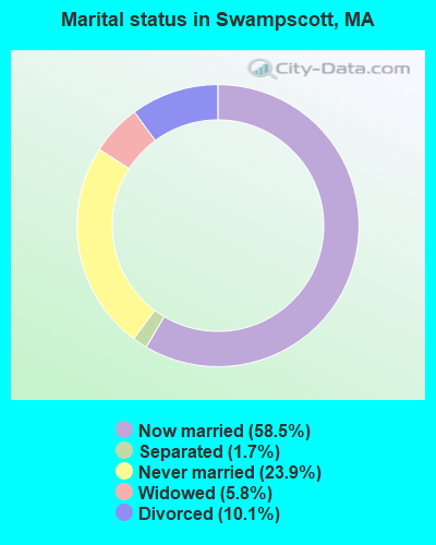
- Never married: 23.9%
- Now married: 58.5%
- Separated: 1.7%
- Widowed: 5.8%
- Divorced: 10.1%
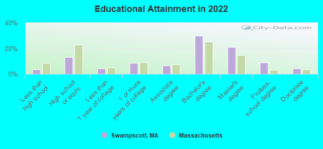
For population 25 years and over in Swampscott:
- High school or higher: 96.8%
- Bachelor's degree or higher: 63.7%
- Graduate or professional degree: 33.2%
- Unemployed: 2.0%
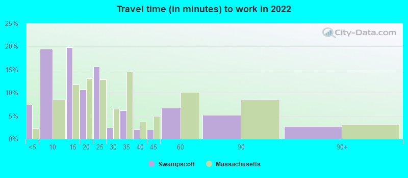
- Mean travel time to work (commute): 26.8 minutes
| Here: | 10.6 |
| Massachusetts average: | 13.0 |


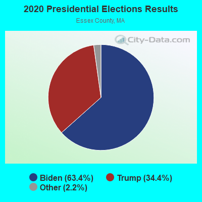
Graphs represent county-level data. Detailed 2008 Election Results
Religion statistics for Swampscott, MA (based on Essex County data)


| Religion | Adherents | Congregations |
|---|---|---|
| Catholic | 341,970 | 55 |
| Mainline Protestant | 33,710 | 140 |
| Evangelical Protestant | 20,925 | 160 |
| Other | 15,882 | 63 |
| Orthodox | 11,590 | 13 |
| Black Protestant | 376 | 3 |
| None | 318,706 | - |
Food Environment Statistics:
| Here: | 1.98 / 10,000 pop. |
| Massachusetts: | 1.98 / 10,000 pop. |
| Essex County: | 0.04 / 10,000 pop. |
| Massachusetts: | 0.05 / 10,000 pop. |
| Here: | 1.97 / 10,000 pop. |
| Massachusetts: | 2.22 / 10,000 pop. |
| Essex County: | 1.30 / 10,000 pop. |
| State: | 1.77 / 10,000 pop. |
| Essex County: | 7.60 / 10,000 pop. |
| Massachusetts: | 8.76 / 10,000 pop. |
| This county: | 8.4% |
| Massachusetts: | 8.1% |
| This county: | 23.7% |
| Massachusetts: | 22.5% |
| This county: | 20.7% |
| State: | 16.5% |
Health and Nutrition:
| Here: | 56.8% |
| Massachusetts: | 50.5% |
| This city: | 56.5% |
| State: | 48.0% |
| Here: | 28.0 |
| Massachusetts: | 28.4 |
| This city: | 18.5% |
| Massachusetts: | 20.7% |
| This city: | 8.1% |
| Massachusetts: | 10.4% |
| Swampscott: | 7.0 |
| State: | 6.8 |
| Swampscott: | 34.4% |
| Massachusetts: | 33.4% |
| Here: | 62.9% |
| Massachusetts: | 57.1% |
| This city: | 80.1% |
| Massachusetts: | 79.2% |
More about Health and Nutrition of Swampscott, MA Residents
5.09% of this county's 2021 resident taxpayers lived in other counties in 2020 ($96,821 average adjusted gross income)
| Here: | 5.09% |
| Massachusetts average: | 6.35% |
0.01% of residents moved from foreign countries ($21 average AGI)
Essex County: 0.01% Massachusetts average: 0.01%
Top counties from which taxpayers relocated into this county between 2020 and 2021:
| from Middlesex County, MA | |
| from Suffolk County, MA | |
| from Rockingham County, NH |
5.47% of this county's 2020 resident taxpayers moved to other counties in 2021 ($95,440 average adjusted gross income)
| Here: | 5.47% |
| Massachusetts average: | 7.18% |
0.01% of residents moved to foreign countries ($53 average AGI)
Essex County: 0.01% Massachusetts average: 0.02%
Top counties to which taxpayers relocated from this county between 2020 and 2021:
| to Middlesex County, MA | |
| to Rockingham County, NH | |
| to Suffolk County, MA |
| Businesses in Swampscott, MA | ||||
| Name | Count | Name | Count | |
|---|---|---|---|---|
| 7-Eleven | 1 | Nike | 2 | |
| Blockbuster | 1 | Panera Bread | 1 | |
| CVS | 1 | RadioShack | 1 | |
| Dunkin Donuts | 2 | Starbucks | 1 | |
| FedEx | 2 | Stop & Shop | 1 | |
| GameStop | 1 | T-Mobile | 1 | |
| Gap | 1 | T.J.Maxx | 1 | |
| JoS. A. Bank | 1 | UPS | 2 | |
| Lane Furniture | 1 | Walgreens | 1 | |
| Marshalls | 1 | Whole Foods Market | 1 | |
| New Balance | 1 | |||
Strongest AM radio stations in Swampscott:
- WRKO (680 AM; 50 kW; BOSTON, MA; Owner: ENTERCOM BOSTON LICENSE, LLC)
- WBZ (1030 AM; 50 kW; BOSTON, MA; Owner: INFINITY BROADCASTING OPERATIONS, INC.)
- WROL (950 AM; 5 kW; BOSTON, MA; Owner: SCA LICENSE CORPORATION)
- WWZN (1510 AM; 50 kW; BOSTON, MA; Owner: ROSE CITY RADIO CORPORATION)
- WEEI (850 AM; 50 kW; BOSTON, MA; Owner: ENTERCOM BOSTON LICENSE, LLC)
- WNSH (1570 AM; 5 kW; BEVERLY, MA)
- WEZE (590 AM; 5 kW; BOSTON, MA; Owner: NEW ENGLAND CONTINENTAL MEDIA, INC.)
- WESX (1230 AM; 1 kW; SALEM, MA; Owner: NORTH SHORE BROADCASTING CORP.)
- WILD (1090 AM; daytime; 5 kW; BOSTON, MA; Owner: RADIO ONE OF BOSTON LICENSES, LLC)
- WRCA (1330 AM; 25 kW; WALTHAM, MA; Owner: WRCA LICENSE, LLC)
- WKOX (1200 AM; 50 kW; FRAMINGHAM, MA; Owner: CAPSTAR TX LIMITED PARTNERSHIP)
- WBIX (1060 AM; 40 kW; NATICK, MA; Owner: LANGER BROADCASTING CORPORATION)
- WXKS (1430 AM; 5 kW; EVERETT, MA; Owner: AMFM RADIO LICENSES, L.L.C.)
Strongest FM radio stations in Swampscott:
- WQSX (93.7 FM; LAWRENCE, MA; Owner: ENTERCOM BOSTON LICENSE, LLC)
- WXKS-FM (107.9 FM; MEDFORD, MA; Owner: AMFM RADIO LICENSES, L.L.C.)
- WMJX (106.7 FM; BOSTON, MA; Owner: GREATER BOSTON RADIO, INC.)
- WMWM (91.7 FM; SALEM, MA; Owner: SALEM STATE COLLEGE BD OF TRUSTEES)
- W267AI (101.3 FM; BOSTON, MA; Owner: MCC BROADCASTING COMPANY, INC.)
- WBCN (104.1 FM; BOSTON, MA; Owner: HEMISPHERE BROADCASTING CORPORATION)
- WZLX (100.7 FM; BOSTON, MA; Owner: INFINITY BROADCASTING CORPORATION OF BOSTON)
- WERS (88.9 FM; BOSTON, MA; Owner: EMERSON COLLEGE)
- WHRB (95.3 FM; CAMBRIDGE, MA; Owner: HARVARD RADIO BROADCASTING CO., INC.)
- WBMX (98.5 FM; BOSTON, MA; Owner: INFINITY RADIO OPERATIONS INC.)
- WJMN (94.5 FM; BOSTON, MA; Owner: AMFM RADIO LICENSES, L.L.C.)
- WFNX (101.7 FM; LYNN, MA; Owner: MCC BROADCASTING COMPANY, INC.)
- WBOS (92.9 FM; BROOKLINE, MA; Owner: GREATER BOSTON RADIO, INC.)
- WCRB (102.5 FM; WALTHAM, MA; Owner: CHARLES RIVER BROADCASTING WCRB LICE)
- WTKK (96.9 FM; BOSTON, MA; Owner: GREATER BOSTON RADIO, INC.)
- WROR-FM (105.7 FM; FRAMINGHAM, MA; Owner: GREATER BOSTON RADIO, INC.)
- WGBH (89.7 FM; BOSTON, MA; Owner: WGBH EDUCATIONAL FOUNDATION)
- WBUR-FM (90.9 FM; BOSTON, MA; Owner: TRUSTEES OF BOSTON UNIVERSITY)
- WODS (103.3 FM; BOSTON, MA; Owner: INFINITY BROADCASTING OPERATIONS, INC.)
- WBOQ (104.9 FM; GLOUCESTER, MA; Owner: MARLIN BROADCASTING, LLC)
TV broadcast stations around Swampscott:
- WBPX (Channel 68; BOSTON, MA; Owner: PAXSON BOSTON-68 LICENSE, INC.)
- WCVB-TV (Channel 5; BOSTON, MA; Owner: WCVB HEARST-ARGYLE TV, INC.)
- WGBH-TV (Channel 2; BOSTON, MA; Owner: WGBH EDUCATIONAL FOUNDATION)
- WTMU-LP (Channel 32; BOSTON, MA; Owner: ZGS BOSTON, INC.)
- WCEA-LP (Channel 58; BOSTON, MA; Owner: CHANNEL 19 TV CORPORATION)
- WHDH-TV (Channel 7; BOSTON, MA; Owner: WHDH-TV)
- WMFP (Channel 62; LAWRENCE, MA; Owner: WSAH LICENSE, INC.)
- WSBK-TV (Channel 38; BOSTON, MA; Owner: VIACOM INC.)
- WLVI-TV (Channel 56; CAMBRIDGE, MA; Owner: WLVI, INC.)
- WBZ-TV (Channel 4; BOSTON, MA; Owner: VIACOM INC.)
- WGBX-TV (Channel 44; BOSTON, MA; Owner: WGBH EDUCATIONAL FOUNDATION)
- WFXT (Channel 25; BOSTON, MA; Owner: FOX TELEVISION STATIONS INC.)
- W40BO (Channel 40; BOSTON, MA; Owner: PAXSON COMMUNICATIONS LPTV, INC.)
- WFXZ-CA (Channel 24; BOSTON, MA; Owner: BOSTON BROADCASTING CORP.)
- WUTF (Channel 66; MARLBOROUGH, MA; Owner: TELEFUTURA BOSTON LLC)
- WWDP (Channel 46; NORWELL, MA; Owner: NORWELL TELEVISION, LLC)
- WUNI (Channel 27; WORCESTER, MA; Owner: ENTRAVISION HOLDINGS, LLC)
- WHDN-LP (Channel 26; BOSTON, MA; Owner: GUENTER MARKSTEINER)
- WNDS (Channel 50; DERRY, NH; Owner: CTV OF DERRY, INC)
- National Bridge Inventory (NBI) Statistics
- 2Number of bridges
- 10ft / 2.9mTotal length
- $2,553,000Total costs
- 57,300Total average daily traffic
- 4,533Total average daily truck traffic
- 87,493Total future (year 2031) average daily traffic
FCC Registered Broadcast Land Mobile Towers:
12 (See the full list of FCC Registered Broadcast Land Mobile Towers in Swampscott, MA)FCC Registered Maritime Coast & Aviation Ground Towers:
2- 425 Humphrey St (Lat: 42.468417 Lon: -70.917833), Type: Building, Overall height: 11 m, Call Sign: WHU743,
Assigned Frequencies: 156.425 MHz, 156.450 MHz, 156.500 MHz, 156.800 MHz, Grant Date: 09/28/1994, Expiration Date: 09/28/1999, Cancellation Date: 05/06/2001, Registrant: Swampscott Yacht Club Inc, Swampscott, MA 01907
- Swampscott Fire Dept 76 Burrill St (Lat: 42.469806 Lon: -70.919778), Type: Building, Structure height: 24 m, Overall height: 33 m, Call Sign: WHW791,
Assigned Frequencies: 156.450 MHz, 156.425 MHz, 156.600 MHz, 156.800 MHz, Grant Date: 10/27/2021, Expiration Date: 09/05/2031, Registrant: Swampscott Fire Department, 76 Burrill St., Swampscott, MA 01907, Phone: (781) 595-4050, Fax: (781) 589-6881, Email:
FCC Registered Amateur Radio Licenses:
69 (See the full list of FCC Registered Amateur Radio Licenses in Swampscott)FAA Registered Aircraft:
1- Aircraft: CESSNA R182 (Category: Land, Seats: 4, Weight: Up to 12,499 Pounds, Speed: 111 mph), Engine: LYCOMING 0-540 SERIES (250 HP) (Reciprocating)
N-Number: 4685T, N4685T, N-4685T, Serial Number: R18201734, Year manufactured: 1981, Airworthiness Date: 03/30/1981, Certificate Issue Date: 03/01/2016
Registrant (Individual): Richard Malagrifa, 25 Pleasant St, Swampscott, MA 01907
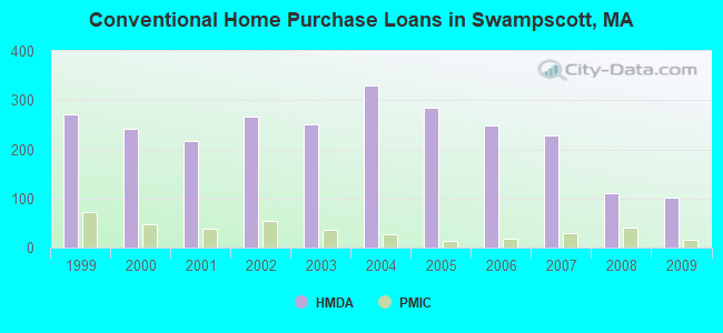
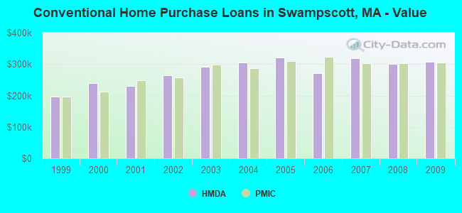
| Home Mortgage Disclosure Act Aggregated Statistics For Year 2009 (Based on 2 full tracts) | ||||||||||
| A) FHA, FSA/RHS & VA Home Purchase Loans | B) Conventional Home Purchase Loans | C) Refinancings | D) Home Improvement Loans | F) Non-occupant Loans on < 5 Family Dwellings (A B C & D) | ||||||
|---|---|---|---|---|---|---|---|---|---|---|
| Number | Average Value | Number | Average Value | Number | Average Value | Number | Average Value | Number | Average Value | |
| LOANS ORIGINATED | 41 | $279,610 | 101 | $308,248 | 588 | $290,588 | 19 | $218,000 | 14 | $259,500 |
| APPLICATIONS APPROVED, NOT ACCEPTED | 1 | $331,000 | 3 | $235,000 | 41 | $265,756 | 0 | $0 | 4 | $261,750 |
| APPLICATIONS DENIED | 4 | $241,000 | 18 | $197,944 | 113 | $323,832 | 10 | $105,600 | 5 | $345,200 |
| APPLICATIONS WITHDRAWN | 1 | $242,000 | 12 | $310,833 | 84 | $291,607 | 3 | $83,333 | 4 | $238,750 |
| FILES CLOSED FOR INCOMPLETENESS | 1 | $271,000 | 2 | $295,000 | 20 | $288,900 | 0 | $0 | 1 | $224,000 |
Detailed HMDA statistics for the following Tracts: 2021.00 , 2022.00
| Private Mortgage Insurance Companies Aggregated Statistics For Year 2009 (Based on 2 full tracts) | ||||
| A) Conventional Home Purchase Loans | B) Refinancings | |||
|---|---|---|---|---|
| Number | Average Value | Number | Average Value | |
| LOANS ORIGINATED | 15 | $304,200 | 15 | $335,200 |
| APPLICATIONS APPROVED, NOT ACCEPTED | 2 | $261,500 | 5 | $276,800 |
| APPLICATIONS DENIED | 4 | $306,250 | 4 | $276,250 |
| APPLICATIONS WITHDRAWN | 2 | $311,000 | 1 | $351,000 |
| FILES CLOSED FOR INCOMPLETENESS | 0 | $0 | 1 | $253,000 |
Detailed PMIC statistics for the following Tracts: 2021.00 , 2022.00
2002 - 2018 National Fire Incident Reporting System (NFIRS) incidents
- Fire incident types reported to NFIRS in Swampscott, MA
- 51755.7%Structure Fires
- 29531.8%Outside Fires
- 697.4%Mobile Property/Vehicle Fires
- 475.1%Other
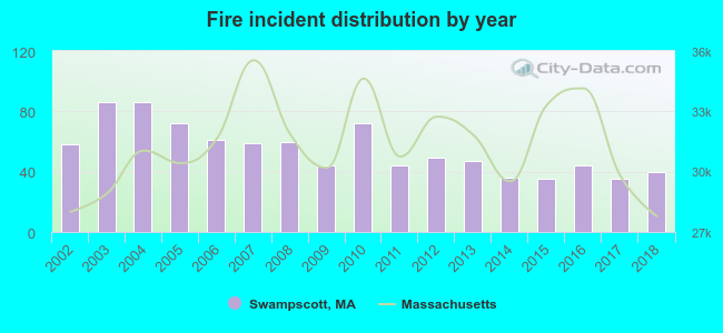 According to the data from the years 2002 - 2018 the average number of fire incidents per year is 55. The highest number of reported fires - 86 took place in 2003, and the least - 35 in 2015. The data has a declining trend.
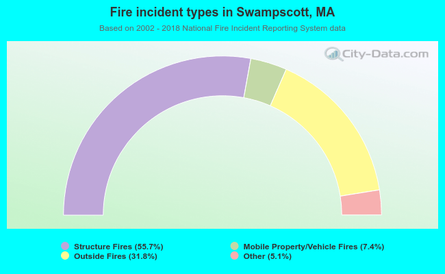 When looking into fire subcategories, the most incidents belonged to: Structure Fires (55.7%), and Outside Fires (31.8%).
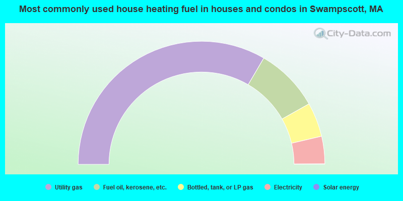
- 66.8%Utility gas
- 16.8%Fuel oil, kerosene, etc.
- 9.0%Bottled, tank, or LP gas
- 7.2%Electricity
- 0.1%Solar energy
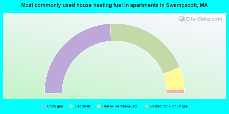
- 48.0%Utility gas
- 40.0%Electricity
- 10.2%Fuel oil, kerosene, etc.
- 1.8%Bottled, tank, or LP gas
Swampscott compared to Massachusetts state average:
- Unemployed percentage significantly below state average.
- Black race population percentage below state average.
- Hispanic race population percentage below state average.
- Median age above state average.
- Renting percentage below state average.
- Length of stay since moving in above state average.
- Percentage of population with a bachelor's degree or higher above state average.
Swampscott on our top lists:
- #25 on the list of "Top 101 cities with the most residents born in Russia (population 500+)"
- #29 on the list of "Top 101 cities with the most residents born in Belarus (population 500+)"
- #44 on the list of "Top 101 cities with the largest positive percentage difference between never married females and males (15+ years) (with at least 1,000 females never married)"
- #65 on the list of "Top 101 cities with the most people taking subway or elevated to work (population 5,000+)"
- #93 on the list of "Top 101 cities with the most residents born in Eastern Europe (population 500+)"
- #21 on the list of "Top 101 counties with the lowest percentage of residents that keep firearms around their homes"
- #21 on the list of "Top 101 counties with the most Orthodox adherents"
- #23 on the list of "Top 101 counties with the highest carbon monoxide air pollution readings in 2012 (ppm)"
- #30 on the list of "Top 101 counties with the most Catholic adherents"
- #36 on the list of "Top 101 counties with the most Orthodox congregations (pop. 50,000+)"

|
|
Total of 367 patent applications in 2008-2024.