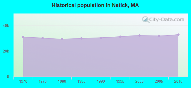
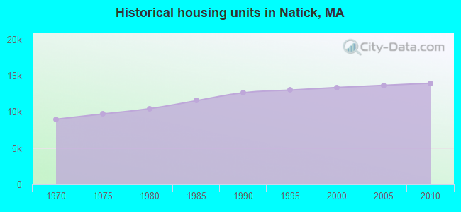
Natick, Massachusetts

Natick: sunset in Pegan Cove Park Natick

Natick: Pegan Cove Park Natick
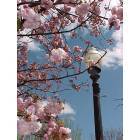
Natick: Cherry blossoms in Town Square

Natick: Pair of Geese on the Charles River, near South Natick dam
- add
your
Submit your own pictures of this town and show them to the world
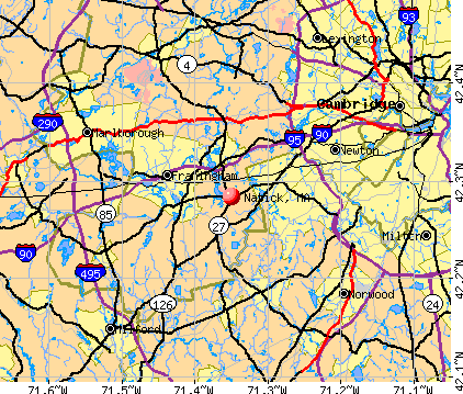
- OSM Map
- General Map
- Google Map
- MSN Map
Population change since 2000: +2.6%
 |
| Males: 15,874 | |
| Females: 17,132 |
| Median resident age: | 41.1 years |
| Massachusetts median age: | 39.2 years |
Zip codes: 01760.
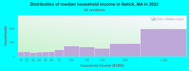
| Natick: | $136,251 |
| MA: | $94,488 |
Estimated per capita income in 2022: $75,486 (it was $36,358 in 2000)
Natick town income, earnings, and wages data
Estimated median house or condo value in 2022: $686,560 (it was $242,900 in 2000)
| Natick: | $686,560 |
| MA: | $534,700 |
Mean prices in 2022: all housing units: $796,617; detached houses: $834,667; townhouses or other attached units: $772,440; in 2-unit structures: $786,250; in 3-to-4-unit structures: $655,835; in 5-or-more-unit structures: $590,321; mobile homes: $144,935
Detailed information about poverty and poor residents in Natick, MA


Compare current foreclosures near Natick, MA:
| Photo | Address | Area | Beds / Baths | Price | Details |
|---|---|---|---|---|---|

|
#1
East St
Natick, MA 01760
|
882 sq. feet
|
1 baths 2 beds |
show details | |

|
#2
N Main St
Natick, MA 01760
|
1,656 sq. feet
|
2 baths 4 beds |
show details | |

|
#3
Kinsman Pl
Natick, MA 01760
|
3,616 sq. feet
|
2 baths 3 beds |
show details | |

|
#4
W Central St
Natick, MA 01760
|
3,236 sq. feet
|
3 baths 4 beds |
show details | |

|
#5
Cordial Way
Natick, MA 01760
|
3,371 sq. feet
|
2 baths 3 beds |
show details | |

|
#6
Pine St
Natick, MA 01760
|
1,241 sq. feet
|
1 baths 3 beds |
show details | |

|
#7
W Central St
Natick, MA 01760
|
- sq. feet
|
- baths - beds |
show details | |

|
#8
Speen St Apt 802
Natick, MA 01760
|
- sq. feet
|
- baths - beds |
show details | |

|
#9
Highland St
Natick, MA 01760
|
- sq. feet
|
- baths - beds |
show details | |

|
#10
Everett St
Natick, MA 01760
|
- sq. feet
|
- baths - beds |
show details |
| Photo | Address | Area | Beds / Baths | Price | Details |
|---|---|---|---|---|---|

|
#11
Stillman St
Framingham, MA 01702
|
1,122 sq. feet
|
1 baths 2 beds |
$440,000
|
show details |

|
#12
Boyd St
Boston, MA 02124
|
3,970 sq. feet
|
3 baths 9 beds |
$650,000
|
show details |

|
#13
Church St
Boston, MA 02122
|
3,663 sq. feet
|
3 baths 6 beds |
show details | |

|
#14
Bloomfield St
Boston, MA 02124
|
2,667 sq. feet
|
2 baths 6 beds |
show details | |

|
#15
Mallard Dr
Medway, MA 02053
|
2,024 sq. feet
|
2 baths 5 beds |
show details | |

|
#16
Baker St
West Roxbury, MA 02132
|
2,614 sq. feet
|
3 baths 4 beds |
show details | |

|
#17
Savin Hill Avenue, Unit 2 190 Savin Hill Avenue Condominium
Boston, MA 02125
|
1,022 sq. feet
|
1 baths 2 beds |
show details | |

|
#18
Ballou St
Quincy, MA 02169
|
1,758 sq. feet
|
1 baths 3 beds |
show details | |

|
#19
Laarhoven Ter
Stoughton, MA 02072
|
1,034 sq. feet
|
1 baths 3 beds |
show details | |

|
#20
Lena Lane Unit 1, 25-27 Lena Lane Condominium
Milford, MA 01757
|
990 sq. feet
|
1 baths 2 beds |
show details |
| Photo | Address | Area | Beds / Baths | Price | Details |
|---|---|---|---|---|---|

|
#21
Brahms St
Roslindale, MA 02131
|
1,604 sq. feet
|
1 baths 4 beds |
show details | |

|
#22
Gallivan Blvd
Boston, MA 02124
|
1,620 sq. feet
|
1 baths 4 beds |
show details | |

|
#23
Victoria Cir
Norwood, MA 02062
|
2,980 sq. feet
|
3 baths 5 beds |
show details | |

|
#24
Laurelwood Dr # No
Hopedale, MA 01747
|
1,440 sq. feet
|
1 baths 2 beds |
show details | |

|
#25
Ridgehill Rd
Canton, MA 02021
|
1,196 sq. feet
|
1 baths 3 beds |
show details | |

|
#26
Hadley St # 2
Medford, MA 02155
|
1,866 sq. feet
|
1 baths 3 beds |
show details | |

|
#27
Forest St
Boston, MA 02119
|
1,540 sq. feet
|
1 baths 3 beds |
show details | |

|
#28
Everett Cir
Hopkinton, MA 01748
|
5,180 sq. feet
|
3 baths 4 beds |
show details | |

|
#29
Greendale Ave
Marlborough, MA 01752
|
2,200 sq. feet
|
3 baths 5 beds |
show details | |

|
#30
Washington St
Hyde Park, MA 02136
|
2,980 sq. feet
|
3 baths 5 beds |
show details |
| Photo | Address | Area | Beds / Baths | Price | Details |
|---|---|---|---|---|---|

|
#31
Old Bolton Rd
Hudson, MA 01749
|
1,244 sq. feet
|
1 baths 3 beds |
show details | |

|
#32
Cedar St
Ashland, MA 01721
|
2,756 sq. feet
|
3 baths 4 beds |
show details | |

|
#33
Iroquois St
Boston, MA 02120
|
2,524 sq. feet
|
1 baths 4 beds |
show details | |

|
#34
Alberta Dr
Hudson, MA 01749
|
2,845 sq. feet
|
2 baths 3 beds |
show details | |

|
#35
Congress Pl
Dedham, MA 02026
|
1,966 sq. feet
|
2 baths 4 beds |
show details | |

|
#36
Gordon St
Allston, MA 02134
|
3,246 sq. feet
|
2 baths 5 beds |
show details | |

|
#37
Lawrence Ave
Boston, MA 02121
|
3,366 sq. feet
|
2 baths 5 beds |
show details | |

|
#38
Magnolia St
Boston, MA 02125
|
3,654 sq. feet
|
3 baths 6 beds |
show details | |

|
#39
Pacific St
Boston, MA 02127
|
2,535 sq. feet
|
1 baths 7 beds |
show details | |

|
#40
Rosewood St
Mattapan, MA 02126
|
1,584 sq. feet
|
1 baths 3 beds |
show details |
| Photo | Address | Area | Beds / Baths | Price | Details |
|---|---|---|---|---|---|

|
#41
Mattapan St
Mattapan, MA 02126
|
1,040 sq. feet
|
1 baths 3 beds |
show details | |

|
#42
Atlantic Ave Unit 15k
Boston, MA 02210
|
3,385 sq. feet
|
4 baths 2 beds |
show details | |

|
#43
Atherton St
Boston, MA 02119
|
3,238 sq. feet
|
2 baths 6 beds |
show details | |

|
#44
Wensley St
Boston, MA 02120
|
1,407 sq. feet
|
1 baths 3 beds |
show details | |

|
#45
Massasoit St
Hyde Park, MA 02136
|
1,420 sq. feet
|
1 baths 4 beds |
show details | |

|
#46
Sunny Knoll Ave
Lexington, MA 02421
|
1,726 sq. feet
|
2 baths 3 beds |
show details | |

|
#47
W Walnut Pk
Boston, MA 02119
|
2,948 sq. feet
|
2 baths 4 beds |
show details | |

|
#48
Oakland Pkwy
Franklin, MA 02038
|
2,184 sq. feet
|
1 baths 5 beds |
show details | |

|
#49
Brigham St Unit 1a
Hudson, MA 01749
|
1,140 sq. feet
|
2 baths 2 beds |
show details | |

|
Check over 1 million property listings on Foreclosure.com!
|
browse all offers | |||

- 28,18985.4%White alone
- 2,3757.2%Asian alone
- 9943.0%Hispanic
- 6472.0%Black alone
- 5881.8%Two or more races
- 1760.5%Other race alone
- 280.08%American Indian alone
- 90.03%Native Hawaiian and Other
Pacific Islander alone
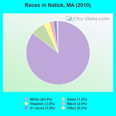
Races in Natick detailed stats: ancestries, foreign born residents, place of birth
According to our research of Massachusetts and other state lists, there were 5 registered sex offenders living in Natick, Massachusetts as of May 06, 2024.
The ratio of all residents to sex offenders in Natick is 6,601 to 1.
The ratio of registered sex offenders to all residents in this city is much lower than the state average.
Type |
2009 |
2010 |
2011 |
2012 |
2013 |
2014 |
2015 |
2016 |
2017 |
2018 |
2019 |
2020 |
2021 |
2022 |
|---|---|---|---|---|---|---|---|---|---|---|---|---|---|---|
| Murders (per 100,000) | 0 (0.0) | 0 (0.0) | 0 (0.0) | 0 (0.0) | 1 (2.9) | 0 (0.0) | 0 (0.0) | 0 (0.0) | 0 (0.0) | 0 (0.0) | 0 (0.0) | 0 (0.0) | 0 (0.0) | 0 (0.0) |
| Rapes (per 100,000) | 1 (3.1) | 5 (15.1) | 4 (12.0) | 4 (11.9) | 2 (5.9) | 4 (11.1) | 7 (19.3) | 6 (16.3) | 4 (10.9) | 19 (51.7) | 7 (19.3) | 1 (2.8) | 9 (24.8) | 9 (24.9) |
| Robberies (per 100,000) | 6 (18.5) | 10 (30.3) | 5 (15.1) | 7 (20.8) | 3 (8.8) | 3 (8.4) | 6 (16.6) | 9 (24.5) | 2 (5.4) | 1 (2.7) | 4 (11.0) | 9 (24.9) | 6 (16.5) | 6 (16.6) |
| Assaults (per 100,000) | 46 (141.9) | 48 (145.4) | 36 (108.4) | 50 (148.6) | 30 (88.0) | 47 (131.0) | 42 (116.1) | 44 (119.6) | 33 (89.9) | 36 (98.0) | 26 (71.5) | 22 (60.8) | 32 (88.1) | 38 (105.3) |
| Burglaries (per 100,000) | 69 (212.8) | 76 (230.3) | 52 (156.6) | 84 (249.7) | 63 (184.8) | 43 (119.8) | 38 (105.0) | 38 (103.3) | 46 (125.3) | 27 (73.5) | 22 (60.5) | 21 (58.0) | 24 (66.0) | 34 (94.2) |
| Thefts (per 100,000) | 804 (2,480) | 665 (2,015) | 567 (1,707) | 683 (2,030) | 468 (1,373) | 449 (1,251) | 479 (1,324) | 452 (1,229) | 397 (1,082) | 388 (1,057) | 352 (968.2) | 342 (944.8) | 389 (1,070) | 469 (1,300) |
| Auto thefts (per 100,000) | 23 (70.9) | 25 (75.7) | 18 (54.2) | 26 (77.3) | 14 (41.1) | 10 (27.9) | 12 (33.2) | 14 (38.1) | 13 (35.4) | 10 (27.2) | 11 (30.3) | 30 (82.9) | 19 (52.3) | 9 (24.9) |
| Arson (per 100,000) | 2 (6.2) | 1 (3.0) | 1 (3.0) | 2 (5.9) | 2 (5.9) | 1 (2.8) | 0 (0.0) | 3 (8.2) | 1 (2.7) | 0 (0.0) | 2 (5.5) | 1 (2.8) | 2 (5.5) | 2 (5.5) |
| City-Data.com crime index | 156.2 | 153.1 | 119.4 | 150.3 | 102.0 | 98.3 | 106.6 | 103.8 | 83.2 | 111.4 | 78.4 | 70.3 | 94.0 | 106.6 |
The City-Data.com crime index weighs serious crimes and violent crimes more heavily. Higher means more crime, U.S. average is 246.1. It adjusts for the number of visitors and daily workers commuting into cities.
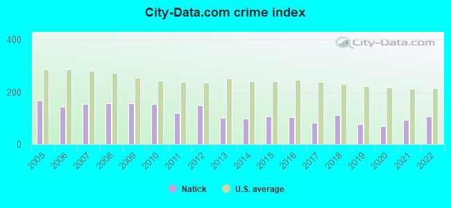
Crime rate in Natick detailed stats: murders, rapes, robberies, assaults, burglaries, thefts, arson
Full-time law enforcement employees in 2021, including police officers: 73 (57 officers - 51 male; 6 female).
| Officers per 1,000 residents here: | 1.57 |
| Massachusetts average: | 2.53 |
 Recent articles from our blog. Our writers, many of them Ph.D. graduates or candidates, create easy-to-read articles on a wide variety of topics.

 | Moving to Mass - Needham vs Norwood vs Natick? (42 replies) |
| Natick, Wayland, or Sudbury? (30 replies) |
| Is West Natick area dangerous? (22 replies) |
| desirability of Burlington vs Natick (61 replies) |
| appreciation potential of buying in Natick? (147 replies) |
| Natick neighborhoods and schools (37 replies) |
Latest news from Natick, MA collected exclusively by city-data.com from local newspapers, TV, and radio stations
Natick, MA City Guides:
Ancestries: Irish (26.1%), Italian (16.3%), English (14.7%), German (8.1%), Polish (4.7%), French (4.5%).
Current Local Time: EST time zone
Incorporated in 1781
Elevation: 180 feet
Land area: 15.1 square miles.
Population density: 2,188 people per square mile (low).
3,168 residents are foreign born (3.7% Europe, 3.1% Asia, 1.7% Latin America, 1.2% North America).
| This town: | 9.8% |
| Massachusetts: | 12.2% |
| Natick town: | 1.2% ($2,866) |
| Massachusetts: | 1.3% ($2,336) |
Nearest city with pop. 50,000+: Framingham, MA  (3.8 miles , pop. 66,910).
Nearest city with pop. 200,000+: Boston, MA (13.7 miles , pop. 589,141).
Nearest city with pop. 1,000,000+: Bronx, NY (164.2 miles , pop. 1,332,650).
Nearest cities:
), ), ), ), Latitude: 42.29 N, Longitude: 71.35 W
Area codes: 508, 774
Natick tourist attractions:
Natick, Massachusetts accommodation & food services, waste management - Economy and Business Data
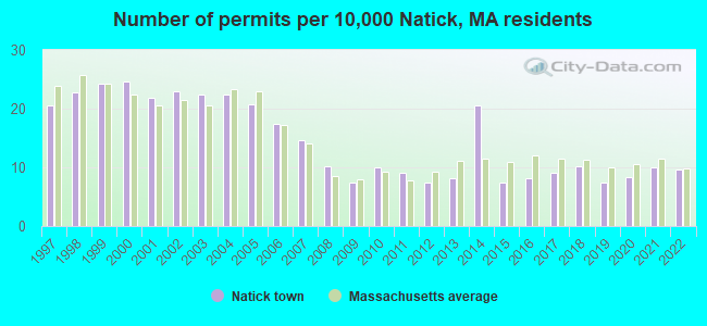
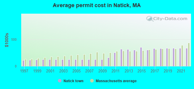
Single-family new house construction building permits:
- 2022: 31 buildings, average cost: $337,300
- 2021: 32 buildings, average cost: $337,500
- 2020: 27 buildings, average cost: $337,000
- 2019: 24 buildings, average cost: $338,700
- 2018: 33 buildings, average cost: $333,000
- 2017: 29 buildings, average cost: $331,100
- 2016: 26 buildings, average cost: $302,300
- 2015: 24 buildings, average cost: $355,700
- 2014: 66 buildings, average cost: $303,100
- 2013: 26 buildings, average cost: $313,800
- 2012: 24 buildings, average cost: $323,100
- 2011: 29 buildings, average cost: $254,800
- 2010: 32 buildings, average cost: $162,600
- 2009: 24 buildings, average cost: $125,500
- 2008: 33 buildings, average cost: $125,500
- 2007: 47 buildings, average cost: $125,500
- 2006: 56 buildings, average cost: $125,500
- 2005: 67 buildings, average cost: $125,500
- 2004: 72 buildings, average cost: $125,500
- 2003: 72 buildings, average cost: $125,500
- 2002: 74 buildings, average cost: $125,600
- 2001: 70 buildings, average cost: $125,400
- 2000: 79 buildings, average cost: $126,000
- 1999: 78 buildings, average cost: $122,900
- 1998: 73 buildings, average cost: $117,000
- 1997: 66 buildings, average cost: $111,800
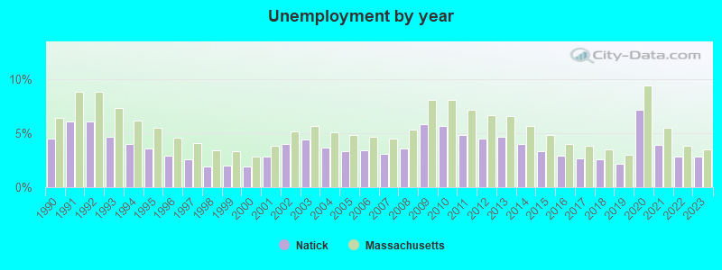
| Here: | 2.8% |
| Massachusetts: | 3.5% |
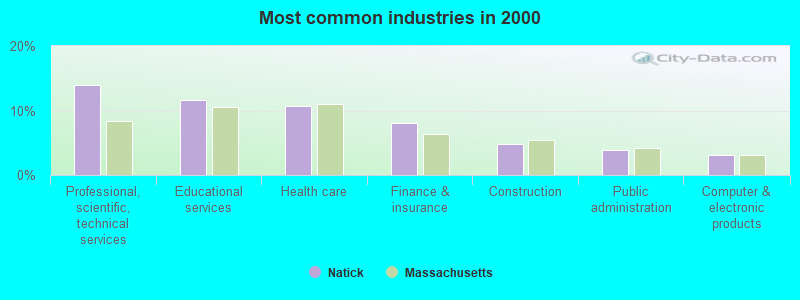
- Professional, scientific, technical services (13.9%)
- Educational services (11.6%)
- Health care (10.7%)
- Finance & insurance (8.1%)
- Construction (4.8%)
- Public administration (3.8%)
- Computer & electronic products (3.1%)
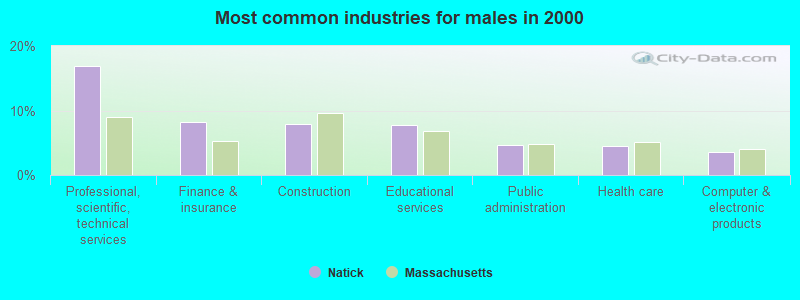
- Professional, scientific, technical services (16.9%)
- Finance & insurance (8.2%)
- Construction (7.9%)
- Educational services (7.8%)
- Public administration (4.7%)
- Health care (4.5%)
- Computer & electronic products (3.5%)
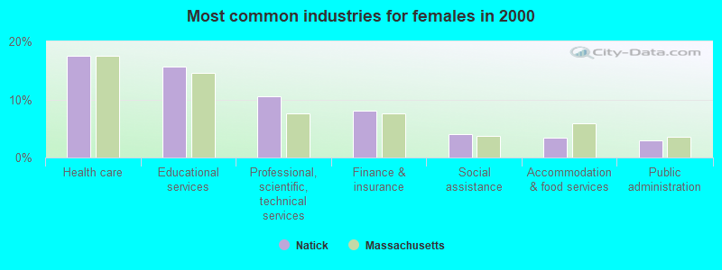
- Health care (17.4%)
- Educational services (15.7%)
- Professional, scientific, technical services (10.6%)
- Finance & insurance (8.0%)
- Social assistance (4.0%)
- Accommodation & food services (3.4%)
- Public administration (2.9%)

- Computer specialists (5.8%)
- Other management occupations, except farmers and farm managers (5.7%)
- Other office and administrative support workers, including supervisors (3.7%)
- Other sales and related occupations, including supervisors (3.7%)
- Sales representatives, services, wholesale and manufacturing (3.6%)
- Preschool, kindergarten, elementary, and middle school teachers (3.3%)
- Secretaries and administrative assistants (3.0%)
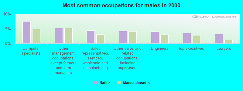
- Computer specialists (7.5%)
- Other management occupations, except farmers and farm managers (5.3%)
- Sales representatives, services, wholesale and manufacturing (4.4%)
- Other sales and related occupations, including supervisors (4.2%)
- Engineers (4.0%)
- Top executives (3.6%)
- Lawyers (3.2%)

- Secretaries and administrative assistants (6.2%)
- Other management occupations, except farmers and farm managers (6.1%)
- Preschool, kindergarten, elementary, and middle school teachers (5.5%)
- Other office and administrative support workers, including supervisors (5.4%)
- Registered nurses (5.3%)
- Computer specialists (3.9%)
- Information and record clerks, except customer service representatives (3.3%)
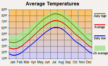
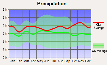
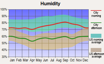
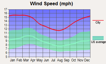
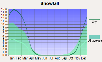
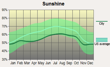
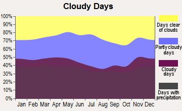
Average climate in Natick, Massachusetts
Based on data reported by over 4,000 weather stations
(lower is better)
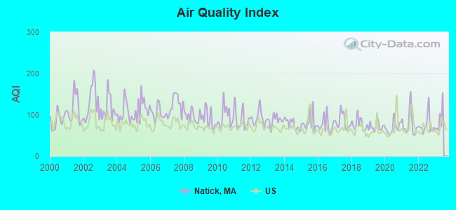
Air Quality Index (AQI) level in 2022 was 74.6. This is about average.
| City: | 74.6 |
| U.S.: | 72.6 |
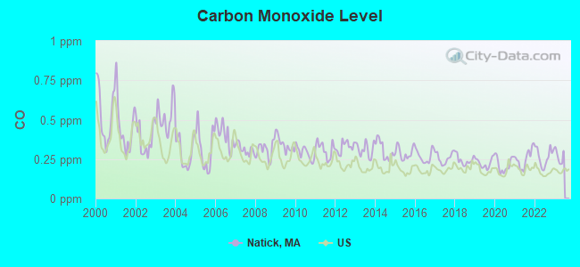
Carbon Monoxide (CO) [ppm] level in 2022 was 0.265. This is about average. Closest monitor was 8.3 miles away from the city center.
| City: | 0.265 |
| U.S.: | 0.251 |
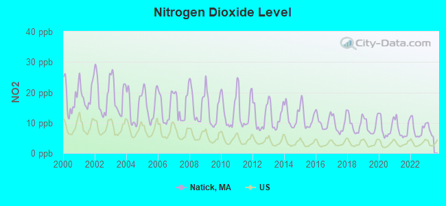
Nitrogen Dioxide (NO2) [ppb] level in 2022 was 7.84. This is significantly worse than average. Closest monitor was 2.9 miles away from the city center.
| City: | 7.84 |
| U.S.: | 5.11 |
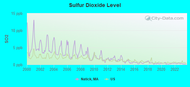
Sulfur Dioxide (SO2) [ppb] level in 2022 was 0.362. This is significantly better than average. Closest monitor was 2.6 miles away from the city center.
| City: | 0.362 |
| U.S.: | 1.515 |
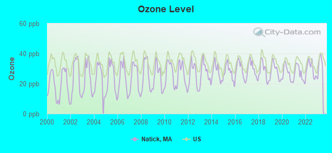
Ozone [ppb] level in 2022 was 29.6. This is about average. Closest monitor was 3.1 miles away from the city center.
| City: | 29.6 |
| U.S.: | 33.3 |
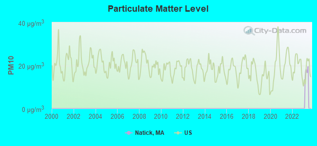
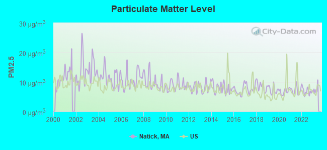
Particulate Matter (PM2.5) [µg/m3] level in 2022 was 6.96. This is about average. Closest monitor was 10.8 miles away from the city center.
| City: | 6.96 |
| U.S.: | 8.11 |
Tornado activity:
Natick-area historical tornado activity is near Massachusetts state average. It is 35% smaller than the overall U.S. average.
On 6/9/1953, a category F4 (max. wind speeds 207-260 mph) tornado 8.5 miles away from the Natick town center killed 90 people and injured 1228 people and caused between $50,000,000 and $500,000,000 in damages.
On 6/9/1953, a category F3 (max. wind speeds 158-206 mph) tornado 18.4 miles away from the town center injured 17 people and caused between $500,000 and $5,000,000 in damages.
Earthquake activity:
Natick-area historical earthquake activity is significantly above Massachusetts state average. It is 73% smaller than the overall U.S. average.On 10/7/1983 at 10:18:46, a magnitude 5.3 (5.1 MB, 5.3 LG, 5.1 ML, Class: Moderate, Intensity: VI - VII) earthquake occurred 189.7 miles away from Natick center
On 4/20/2002 at 10:50:47, a magnitude 5.3 (5.3 ML, Depth: 3.0 mi) earthquake occurred 193.6 miles away from the city center
On 1/19/1982 at 00:14:42, a magnitude 4.7 (4.5 MB, 4.7 MD, 4.5 LG, Class: Light, Intensity: IV - V) earthquake occurred 84.6 miles away from the city center
On 4/20/2002 at 10:50:47, a magnitude 5.2 (5.2 MB, 4.2 MS, 5.2 MW, 5.0 MW) earthquake occurred 192.9 miles away from Natick center
On 10/16/2012 at 23:12:25, a magnitude 4.7 (4.7 ML, Depth: 10.0 mi) earthquake occurred 97.0 miles away from the city center
On 8/22/1992 at 12:20:32, a magnitude 4.8 (4.8 MB, 3.8 MS, 4.7 LG, Depth: 6.2 mi) earthquake occurred 226.9 miles away from Natick center
Magnitude types: regional Lg-wave magnitude (LG), body-wave magnitude (MB), duration magnitude (MD), local magnitude (ML), surface-wave magnitude (MS), moment magnitude (MW)
Natural disasters:
The number of natural disasters in Middlesex County (31) is a lot greater than the US average (15).Major Disasters (Presidential) Declared: 17
Emergencies Declared: 14
Causes of natural disasters: Floods: 12, Storms: 9, Hurricanes: 6, Snowstorms: 6, Winter Storms: 5, Blizzards: 2, Snows: 2, Explosion: 1, Heavy Rain: 1, Snowfall: 1, Water Main Break: 1, Wind: 1 (Note: some incidents may be assigned to more than one category).
Main business address for: VISION SCIENCES INC /DE/ (ELECTROMEDICAL & ELECTROTHERAPEUTIC APPARATUS), BOSTON SCIENTIFIC CORP (SURGICAL & MEDICAL INSTRUMENTS & APPARATUS), BJS WHOLESALE CLUB INC (RETAIL-VARIETY STORES), COGNEX CORP (INDUSTRIAL INSTRUMENTS FOR MEASUREMENT, DISPLAY, AND CONTROL).
Hospitals and medical centers in Natick:
- LEONARD MORSE HOSPITAL (provides emergency services, 67 UNION ST)
- NATICK VISITING NURSE ASSOCIATION (209 WEST CENTRAL STREET SUITE)
- BEAUMONT REHAB AND SKILLED NURSING CTR - NATICK (3 VISION DRIVE)
- KINDRED TRANSITIONAL CARE AND REHABILITATION-ELIOT (168 WEST CENTRAL STREET)
- MARY ANN MORSE NURSING AND REHABILITATION (45 UNION STREET)
Heliports located in Natick:
- Cochituate Heliport (5MA7)
- Natick Army Laboratories Heliport (MA58)
- Us Property & Fiscal Office Heliport (MA57)
Amtrak stations near Natick:
- 4 miles: FRAMINGHAM (443 WAVERLY ST.) . Services: public payphones, snack bar, paid short-term parking, taxi stand, public transit connection.
- 12 miles: ROUTE 128 (WESTWOOD, UNIVERSITY AVE. & RTE. 128) . Services: ticket office, enclosed waiting area, public restrooms, public payphones, vending machines, paid short-term parking, taxi stand, public transit connection.
- 15 miles: BACK BAY (BOSTON, 145 DARTMOUTH ST.) . Services: ticket office, partially wheelchair accessible, enclosed waiting area, public restrooms, public payphones, vending machines, ATM, paid short-term parking, paid long-term parking, call for car rental service, taxi stand, public transit connection.
Colleges/universities with over 2000 students nearest to Natick:
- Wellesley College (about 3 miles; Wellesley, MA; Full-time enrollment: 2,658)
- Framingham State University (about 5 miles; Framingham, MA; FT enrollment: 5,743)
- Babson College (about 5 miles; Wellesley, MA; FT enrollment: 3,230)
- Massachusetts Bay Community College (about 5 miles; Wellesley Hills, MA; FT enrollment: 3,636)
- Brandeis University (about 8 miles; Waltham, MA; FT enrollment: 6,966)
- Bentley University (about 10 miles; Waltham, MA; FT enrollment: 5,229)
- Boston College (about 10 miles; Chestnut Hill, MA; FT enrollment: 12,070)
Public high school in Natick:
- NATICK HIGH (Students: 1,214, Location: 15 WEST STREET, Grades: PK-12)
Private high schools in Natick:
Public elementary/middle schools in Natick:
- WILSON MIDDLE (Students: 805, Location: 22 RUTLEDGE RD, Grades: 5-8)
- BENNETT-HEMENWAY (Students: 632, Location: 22 EAST EVERGREEN RD, Grades: KG-4)
- J F KENNEDY MIDDLE SCHOOL (Students: 505, Location: 165 MILL STREET, Grades: 5-8)
- MEMORIAL (Students: 406, Location: 107 ELIOT STREET, Grades: KG-4)
- LILJA ELEMENTARY (Students: 395, Location: 41 BACON STREET, Grades: KG-4)
- BROWN (Students: 390, Location: 1 JEAN BURKE DRIVE, Grades: KG-4)
- JOHNSON (Students: 220, Location: 99 SOUTH MAIN STREET, Grades: KG-4)
Private elementary/middle schools in Natick:
- RIVERBEND SCHOOL (Students: 153, Location: 6 AUBURN ST, Grades: PK-8)
- THE TOBIN SCHOOL (Students: 57, Location: 73 COTTAGE ST, Grades: PK-4)
Library in Natick:
- MORSE INSTITUTE LIBRARY (Operating income: $2,215,071; Location: 14 EAST CENTRAL STREET; 146,114 books; 14,457 audio materials; 12,307 video materials; 9 local licensed databases; 31 state licensed databases; 3 other licensed databases; 261 print serial subscriptions; 1 electronic serial subscriptions)
Points of interest:
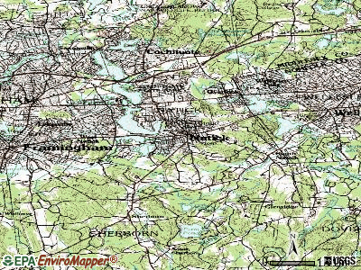
Notable locations in Natick: Natick Station (A), West Natick Station (B), Marino Lookout Farm (C), Natick Laboratories (D), Lakewood Country Club (E), Sherwood Plaza (F), East Natick Industrial Park (G), American Medical Response of Massachusetts (H), Natick Fire Department Station 3 (I), Natick Fire Department Station 2 (J), Natick Fire Department Station 4 (K), Wilson Middle School Library (L), Walnut Hill School Library (M), Natick Fire Department Station 1 Headquarters (N), Leonard Morse Campus Medical Library (O), Morse Institute Library (P), Bacon Free Library (Q), Natick Historical Society Building (R), Natick Historical Society Library (S). Display/hide their locations on the map
Shopping Centers: Natick Mall (1), Natick 9 and 27 Shopping Center (2), Cloverleaf Marketplace Shopping Center (3), Natick Mall Shopping Center (4), Sherwood Plaza Shopping Center (5). Display/hide their locations on the map
Main business address in Natick include: VISION SCIENCES INC /DE/ (A), BOSTON SCIENTIFIC CORP (B), BJS WHOLESALE CLUB INC (C), COGNEX CORP (D). Display/hide their locations on the map
Churches in Natick include: Saint Patricks Church (A), Hartford Street Presbyterian Church (B), Free Daist Communion Church (C), Fisk Memorial United Methodist Church (D), First Lutheran Church (E), First Baptist Church in Natick (F), Eliot Church Federated (G), East Natick United Methodist Church (H), Church of Christ in Natick (I). Display/hide their locations on the map
Cemeteries: Saint Patricks Cemetery (1), Dell Park Cemetery (2), Saint Patricks Cemetery (3), Glenwood Cemetery (4). Display/hide their locations on the map
Lakes and reservoirs: Dug Pond (A), Jennings Pond (B), Mud Pond (C), Nonesuch Pond (D), Pickerel Pond (E), Natick Reservoir (F), Fisk Pond (G), Charles River Reservoir (H). Display/hide their locations on the map
Streams, rivers, and creeks: Steep Brook (A), Davis Brook (B), Course Brook (C), Beaverdam Brook (D). Display/hide their locations on the map
Parks in Natick include: Memorial Field (1), Natick Center Historic District (2), Broadmoore Audubon Reservation (3). Display/hide their locations on the map
Tourist attractions: Canadian Tourism Commission (6 Justin Rd), Natick Historical Society (58 Eliot Street), Natick Tourist Information Center (Massachusetts Turnpi), Aladdins Castle (Arcades & Amusements; 1245 Worcester Street).
Hotels: Boston/Natick Travelodge (1350 Worcester St), Crowne Plaza Natick (Route 9 1360 Worcester Street), Courtyard by Marriott - Boston Natick (342 Speen Street), Hampton Inn Boston/Natick (319 Speen Street), Hampton Inn Boston - Natick (319 Speen St), Courtyard Natick/ Framingham (342 Speen Street).
Court: Mass Commonwealth - Trial Court- Natick Division- Clerk's Office (117 East Central Street).
Birthplace of: Alfred S. Hartwell - Politician, James Bamford - Investigative journalist, Keene Fitzpatrick - Track coach, Eddie Mahan - Football and baseball player and coach, Jonathan Richman - Rock singer, Meg Mallon - Professional golfer, Arthur E. Martell - Chemist, Brian Moran - Politician, Dottie Green - Baseball player, Kent Austin - Football coach.
Drinking water stations with addresses in Natick and their reported violations in the past:
NATICK WATER DEPARTMENT (Population served: 33,006, Groundwater):Past monitoring violations:
- Monitoring, Source Water (GWR) - In NOV-01-2011, Contaminant: E. COLI. Follow-up actions: St AO (w/o penalty) issued (DEC-29-2011)
- Monitoring and Reporting (DBP) - Between JUL-2007 and SEP-2007, Contaminant: TTHM. Follow-up actions: St AO (w/o penalty) issued (OCT-23-2007)
- Monitoring and Reporting (DBP) - Between JUL-2007 and SEP-2007, Contaminant: Total Haloacetic Acids (HAA5). Follow-up actions: St AO (w/o penalty) issued (OCT-23-2007)
- Monitoring and Reporting (DBP) - Between APR-2006 and JUN-2006, Contaminant: TTHM. Follow-up actions: St AO (w/o penalty) issued (DEC-14-2006)
- 47 regular monitoring violations
| This town: | 2.4 people |
| Massachusetts: | 2.5 people |
| This town: | 65.0% |
| Whole state: | 63.0% |
| This town: | 5.1% |
| Whole state: | 7.0% |
Likely homosexual households (counted as self-reported same-sex unmarried-partner households)
- Lesbian couples: 0.6% of all households
- Gay men: 0.3% of all households
| This town: | 2.8% |
| Whole state: | 9.3% |
| This town: | 0.9% |
| Whole state: | 4.4% |
People in group quarters in Natick in 2010:
- 194 people in nursing facilities/skilled-nursing facilities
- 58 people in residential treatment centers for juveniles (non-correctional)
- 56 people in workers' group living quarters and job corps centers
- 25 people in military barracks and dormitories (nondisciplinary)
- 10 people in group homes intended for adults
- 6 people in emergency and transitional shelters (with sleeping facilities) for people experiencing homelessness
- 5 people in other noninstitutional facilities
People in group quarters in Natick in 2000:
- 426 people in nursing homes
- 77 people in other noninstitutional group quarters
- 25 people in military barracks, etc.
- 5 people in mental (psychiatric) hospitals or wards
- 4 people in religious group quarters
- 2 people in homes or halfway houses for drug/alcohol abuse
Banks with branches in Natick (2011 data):
- RBS Citizens, National Association: Natick Stop & Shop Branch, Natick Center Branch, Natick Roche Bros. Branch. Info updated 2007/09/19: Bank assets: $106,940.6 mil, Deposits: $75,690.2 mil, headquarters in Providence, RI, positive income, 1135 total offices, Holding Company: Uk Financial Investments Limited
- Bank of America, National Association: Roche Brothers Supermarket Branch at 152 West Central Street, branch established on 1984/01/11; Natick Branch at 1245 Worcester Road, branch established on 1965/06/21. Info updated 2009/11/18: Bank assets: $1,451,969.3 mil, Deposits: $1,077,176.8 mil, headquarters in Charlotte, NC, positive income, 5782 total offices, Holding Company: Bank Of America Corporation
- Middlesex Savings Bank: Operations Center Branch at 36 Summer Street, branch established on 1976/01/01; at 6 Main Street, branch established on 1835/03/05. Info updated 2009/07/16: Bank assets: $4,034.8 mil, Deposits: $3,490.0 mil, local headquarters, positive income, Mortgage Lending Specialization, 33 total offices, Holding Company: Middlesex Bancorp Mhc
- Sovereign Bank, National Association: Natick East Central St Branch at 69 East Central Street, branch established on 1959/10/15. Info updated 2012/01/31: Bank assets: $78,146.9 mil, Deposits: $48,042.9 mil, headquarters in Wilmington, DE, positive income, Commercial Lending Specialization, 718 total offices, Holding Company: Banco Santander, S.A.
- Eastern Bank: Natick Branch at 2 South Avenue, branch established on 2005/11/21. Info updated 2011/03/30: Bank assets: $7,812.9 mil, Deposits: $6,295.8 mil, headquarters in Boston, MA, positive income, Commercial Lending Specialization, 94 total offices, Holding Company: Eastern Bank Corporation
- Natick Federal Savings Bank: at 49 Main St, branch established on 1886/01/01. Info updated 2011/07/21: Bank assets: $155.6 mil, Deposits: $136.3 mil, local headquarters, negative income in the last year, 1 total offices
For population 15 years and over in Natick:

- Never married: 24.7%
- Now married: 59.3%
- Separated: 1.4%
- Widowed: 6.9%
- Divorced: 7.6%
For population 25 years and over in Natick:
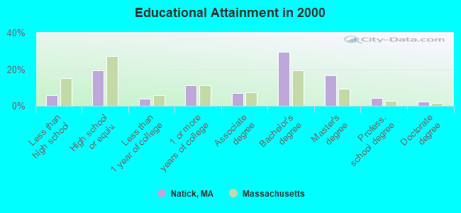
- High school or higher: 94.0%
- Bachelor's degree or higher: 52.5%
- Graduate or professional degree: 23.0%
- Unemployed: 2.1%
- Mean travel time to work (commute): 29.1 minutes
| Here: | 10.6 |
| Massachusetts average: | 13.1 |


Graphs represent county-level data. Detailed 2008 Election Results
Religion statistics for Natick, MA (based on Middlesex County data)


| Religion | Adherents | Congregations |
|---|---|---|
| Catholic | 718,209 | 107 |
| Mainline Protestant | 70,053 | 269 |
| Other | 68,480 | 199 |
| Evangelical Protestant | 41,270 | 304 |
| Orthodox | 23,641 | 28 |
| Black Protestant | 2,276 | 8 |
| None | 579,156 | - |
Food Environment Statistics:
| Middlesex County: | 1.71 / 10,000 pop. |
| Massachusetts: | 1.98 / 10,000 pop. |
| This county: | 0.03 / 10,000 pop. |
| Massachusetts: | 0.05 / 10,000 pop. |
| Middlesex County: | 2.14 / 10,000 pop. |
| Massachusetts: | 2.22 / 10,000 pop. |
| Middlesex County: | 1.38 / 10,000 pop. |
| Massachusetts: | 1.77 / 10,000 pop. |
| Here: | 7.84 / 10,000 pop. |
| State: | 8.76 / 10,000 pop. |
| Middlesex County: | 7.8% |
| State: | 8.1% |
| This county: | 21.5% |
| State: | 22.5% |
| Middlesex County: | 18.0% |
| Massachusetts: | 16.5% |
6.91% of this county's 2021 resident taxpayers lived in other counties in 2020 ($102,955 average adjusted gross income)
| Here: | 6.91% |
| Massachusetts average: | 6.35% |
0.01% of residents moved from foreign countries ($137 average AGI)
Middlesex County: 0.01% Massachusetts average: 0.01%
Top counties from which taxpayers relocated into this county between 2020 and 2021:
| from Suffolk County, MA | |
| from Essex County, MA | |
| from Norfolk County, MA |
8.22% of this county's 2020 resident taxpayers moved to other counties in 2021 ($123,369 average adjusted gross income)
| Here: | 8.22% |
| Massachusetts average: | 7.18% |
0.01% of residents moved to foreign countries ($124 average AGI)
Middlesex County: 0.01% Massachusetts average: 0.02%
Top counties to which taxpayers relocated from this county between 2020 and 2021:
| to Suffolk County, MA | |
| to Essex County, MA | |
| to Worcester County, MA |
| Businesses in Natick, MA | ||||
| Name | Count | Name | Count | |
|---|---|---|---|---|
| 7-Eleven | 2 | J.Crew | 1 | |
| ALDO | 2 | JCPenney | 1 | |
| AT&T | 1 | Jones New York | 2 | |
| Abercrombie & Fitch | 1 | Journeys | 1 | |
| Abercrombie Kids | 1 | Juicy Couture | 1 | |
| Aeropostale | 1 | Justice | 1 | |
| American Eagle Outfitters | 1 | La-Z-Boy | 1 | |
| Ann Taylor | 2 | Lane Bryant | 1 | |
| Apple Store | 1 | Lane Furniture | 1 | |
| Ashley Furniture | 1 | LensCrafters | 2 | |
| Audi | 1 | Levi Strauss & Co. | 1 | |
| AutoZone | 1 | Macy's | 1 | |
| Bakers | 1 | Marriott | 1 | |
| Banana Republic | 1 | MasterBrand Cabinets | 7 | |
| Bath & Body Works | 1 | McDonald's | 3 | |
| Bebe | 1 | Motherhood Maternity | 2 | |
| Ben & Jerry's | 1 | New Balance | 5 | |
| Blockbuster | 1 | New York & Co | 1 | |
| Brooks Brothers | 1 | Nike | 11 | |
| Brookstone | 1 | Nordstrom | 1 | |
| Burlington Coat Factory | 1 | Pac Sun | 1 | |
| CVS | 1 | Panera Bread | 1 | |
| Cache | 1 | Payless | 1 | |
| Casual Male XL | 1 | Pottery Barn Kids | 2 | |
| Chico's | 1 | Quiznos | 1 | |
| Chuck E. Cheese's | 1 | RadioShack | 1 | |
| Clarks | 1 | Sears | 3 | |
| Coldwater Creek | 1 | Sephora | 2 | |
| Crate & Barrel | 1 | Skechers USA | 1 | |
| Curves | 1 | Soma Intimates | 1 | |
| Dairy Queen | 1 | Spencer Gifts | 1 | |
| Decora Cabinetry | 4 | Sprint Nextel | 1 | |
| DressBarn | 1 | Staples | 1 | |
| Dressbarn | 1 | Starbucks | 1 | |
| Dunkin Donuts | 6 | Stop & Shop | 1 | |
| Express | 1 | Subaru | 1 | |
| FedEx | 6 | Subway | 2 | |
| Finish Line | 1 | T-Mobile | 2 | |
| Firestone Complete Auto Care | 1 | Talbots | 1 | |
| Forever 21 | 1 | The Cheesecake Factory | 1 | |
| GNC | 1 | The Limited | 1 | |
| GameStop | 2 | Travelodge | 1 | |
| Gap | 1 | U-Haul | 3 | |
| Gymboree | 1 | UPS | 10 | |
| H&R Block | 1 | Urban Outfitters | 1 | |
| Hilton | 1 | Vans | 2 | |
| Holiday Inn | 1 | Verizon Wireless | 2 | |
| Hollister Co. | 1 | Victoria's Secret | 1 | |
| Home Depot | 1 | Walgreens | 1 | |
| Honda | 1 | Wendy's | 2 | |
| J. Jill | 1 | Wet Seal | 1 | |
Strongest AM radio stations in Natick:
- WEEI (850 AM; 50 kW; BOSTON, MA; Owner: ENTERCOM BOSTON LICENSE, LLC)
- WKOX (1200 AM; 50 kW; FRAMINGHAM, MA; Owner: CAPSTAR TX LIMITED PARTNERSHIP)
- WBIX (1060 AM; 40 kW; NATICK, MA; Owner: LANGER BROADCASTING CORPORATION)
- WAMG (890 AM; 25 kW; DEDHAM, MA; Owner: MEGA COMMUNICATIONS OF DEDHAM LICENSEE, LLC)
- WRCA (1330 AM; 25 kW; WALTHAM, MA; Owner: WRCA LICENSE, LLC)
- WWZN (1510 AM; 50 kW; BOSTON, MA; Owner: ROSE CITY RADIO CORPORATION)
- WRKO (680 AM; 50 kW; BOSTON, MA; Owner: ENTERCOM BOSTON LICENSE, LLC)
- WUNR (1600 AM; 20 kW; BROOKLINE, MA; Owner: CHAMPION BROADCASTING SYSTEMS, INC.)
- WSRO (650 AM; 2 kW; ASHLAND, MA; Owner: LANGER BROADCASTING GROUP, LLC)
- WNTN (1550 AM; 10 kW; NEWTON, MA; Owner: COLT COMMUNICATIONS, LLC)
- WBZ (1030 AM; 50 kW; BOSTON, MA; Owner: INFINITY BROADCASTING OPERATIONS, INC.)
- WALE (990 AM; 50 kW; GREENVILLE, RI; Owner: NORTH AMERICAN BROADCASTING CO., INC.)
- WCRN (830 AM; 50 kW; WORCESTER, MA; Owner: CARTER BROADCASTING CORPORATION)
Strongest FM radio stations in Natick:
- WGBH (89.7 FM; BOSTON, MA; Owner: WGBH EDUCATIONAL FOUNDATION)
- WBMX (98.5 FM; BOSTON, MA; Owner: INFINITY RADIO OPERATIONS INC.)
- WJMN (94.5 FM; BOSTON, MA; Owner: AMFM RADIO LICENSES, L.L.C.)
- WCRB (102.5 FM; WALTHAM, MA; Owner: CHARLES RIVER BROADCASTING WCRB LICE)
- WTKK (96.9 FM; BOSTON, MA; Owner: GREATER BOSTON RADIO, INC.)
- WROR-FM (105.7 FM; FRAMINGHAM, MA; Owner: GREATER BOSTON RADIO, INC.)
- WBOS (92.9 FM; BROOKLINE, MA; Owner: GREATER BOSTON RADIO, INC.)
- WBUR-FM (90.9 FM; BOSTON, MA; Owner: TRUSTEES OF BOSTON UNIVERSITY)
- WODS (103.3 FM; BOSTON, MA; Owner: INFINITY BROADCASTING OPERATIONS, INC.)
- WZLY (91.5 FM; WELLESLEY, MA; Owner: WELLESLEY COLLEGE)
- WXKS-FM (107.9 FM; MEDFORD, MA; Owner: AMFM RADIO LICENSES, L.L.C.)
- WMJX (106.7 FM; BOSTON, MA; Owner: GREATER BOSTON RADIO, INC.)
- WBCN (104.1 FM; BOSTON, MA; Owner: HEMISPHERE BROADCASTING CORPORATION)
- WZLX (100.7 FM; BOSTON, MA; Owner: INFINITY BROADCASTING CORPORATION OF BOSTON)
- W267AI (101.3 FM; BOSTON, MA; Owner: MCC BROADCASTING COMPANY, INC.)
- WERS (88.9 FM; BOSTON, MA; Owner: EMERSON COLLEGE)
- WYAJ (97.7 FM; SUDBURY, MA; Owner: SUDBURY VALLEY B'CASTING FOUNDATION)
- WHRB (95.3 FM; CAMBRIDGE, MA; Owner: HARVARD RADIO BROADCASTING CO., INC.)
- WHHB (99.9 FM; HOLLISTON, MA; Owner: HOLLISTON HIGH SCHOOL)
- WAAF (107.3 FM; WORCESTER, MA; Owner: ENTERCOM BOSTON LICENSE, LLC)
TV broadcast stations around Natick:
- WCVB-TV (Channel 5; BOSTON, MA; Owner: WCVB HEARST-ARGYLE TV, INC.)
- WGBH-TV (Channel 2; BOSTON, MA; Owner: WGBH EDUCATIONAL FOUNDATION)
- WBZ-TV (Channel 4; BOSTON, MA; Owner: VIACOM INC.)
- WGBX-TV (Channel 44; BOSTON, MA; Owner: WGBH EDUCATIONAL FOUNDATION)
- WMFP (Channel 62; LAWRENCE, MA; Owner: WSAH LICENSE, INC.)
- WHDH-TV (Channel 7; BOSTON, MA; Owner: WHDH-TV)
- WSBK-TV (Channel 38; BOSTON, MA; Owner: VIACOM INC.)
- WLVI-TV (Channel 56; CAMBRIDGE, MA; Owner: WLVI, INC.)
- WFXT (Channel 25; BOSTON, MA; Owner: FOX TELEVISION STATIONS INC.)
- W40BO (Channel 40; BOSTON, MA; Owner: PAXSON COMMUNICATIONS LPTV, INC.)
- WUTF (Channel 66; MARLBOROUGH, MA; Owner: TELEFUTURA BOSTON LLC)
- WBPX (Channel 68; BOSTON, MA; Owner: PAXSON BOSTON-68 LICENSE, INC.)
- WUNI (Channel 27; WORCESTER, MA; Owner: ENTRAVISION HOLDINGS, LLC)
- WTMU-LP (Channel 32; BOSTON, MA; Owner: ZGS BOSTON, INC.)
- WCEA-LP (Channel 58; BOSTON, MA; Owner: CHANNEL 19 TV CORPORATION)
- WWDP (Channel 46; NORWELL, MA; Owner: NORWELL TELEVISION, LLC)
- WNAC-TV (Channel 64; PROVIDENCE, RI; Owner: WNAC, LLC)
- WPRI-TV (Channel 12; PROVIDENCE, RI; Owner: TVL BROADCASTING OF RHODE ISLAND, LLC)
- WLNE-TV (Channel 6; NEW BEDFORD, MA; Owner: FREEDOM BROADCASTING OF SOUTHERN NEW ENGLAND, INC.)
- WJAR (Channel 10; PROVIDENCE, RI; Owner: OUTLET BROADCASTING, INC.)
- WFXZ-CA (Channel 24; BOSTON, MA; Owner: BOSTON BROADCASTING CORP.)
- WSBE-TV (Channel 36; PROVIDENCE, RI; Owner: RHODE ISLAND PUBLIC TELECOM. AUTHORITY)
- WPXQ (Channel 69; BLOCK ISLAND, RI; Owner: OCEAN STATE TELEVISION, L.L.C.)
- WYDN (Channel 48; WORCESTER, MA; Owner: EDUCATIONAL PUBLIC TV CORPORATION)
- National Bridge Inventory (NBI) Statistics
- 32Number of bridges
- 207ft / 63.1mTotal length
- $49,488,000Total costs
- 888,222Total average daily traffic
- 44,419Total average daily truck traffic
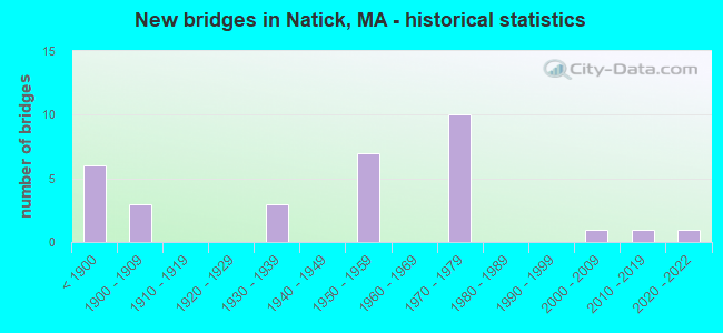
- New bridges - historical statistics
- 6Before 1900
- 31900-1909
- 31930-1939
- 71950-1959
- 101970-1979
- 12000-2009
- 12010-2019
- 12020-2022
FCC Registered Commercial Land Mobile Towers: 1 (See the full list of FCC Registered Commercial Land Mobile Towers in Natick, MA)
FCC Registered Private Land Mobile Towers: 1 (See the full list of FCC Registered Private Land Mobile Towers)
FCC Registered Broadcast Land Mobile Towers: 40 (See the full list of FCC Registered Broadcast Land Mobile Towers)
FCC Registered Microwave Towers: 21 (See the full list of FCC Registered Microwave Towers in this town)
FCC Registered Paging Towers: 1 (See the full list of FCC Registered Paging Towers)
FCC Registered Amateur Radio Licenses: 194 (See the full list of FCC Registered Amateur Radio Licenses in Natick)
FAA Registered Aircraft Manufacturers and Dealers: 2 (See the full list of FAA Registered Manufacturers and Dealers in Natick)
FAA Registered Aircraft: 10 (See the full list of FAA Registered Aircraft)
2002 - 2018 National Fire Incident Reporting System (NFIRS) incidents
- Fire incident types reported to NFIRS in Natick, MA
- 77548.7%Structure Fires
- 50631.8%Outside Fires
- 19112.0%Mobile Property/Vehicle Fires
- 1217.6%Other
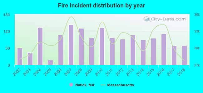 According to the data from the years 2002 - 2018 the average number of fire incidents per year is 94. The highest number of reported fire incidents - 144 took place in 2007, and the least - 18 in 2005. The data has a growing trend.
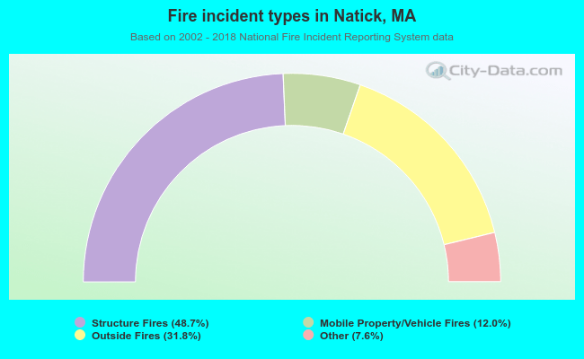 When looking into fire subcategories, the most reports belonged to: Structure Fires (48.7%), and Outside Fires (31.8%).
Fire-safe hotels and motels in Natick, Massachusetts:
- Hampton Inn Boston/Natick, 319 Speen St, Natick, Massachusetts 01760 , Phone: (508) 653-5000, Fax: (508) 651-9733
- Courtyard By Marriott Boston/Natick, 342 Speen St, Natick, Massachusetts 01760 , Phone: (508) 655-6100, Fax: (508) 655-6104

- 46.9%Fuel oil, kerosene, etc.
- 42.4%Utility gas
- 9.7%Electricity
- 0.7%Bottled, tank, or LP gas
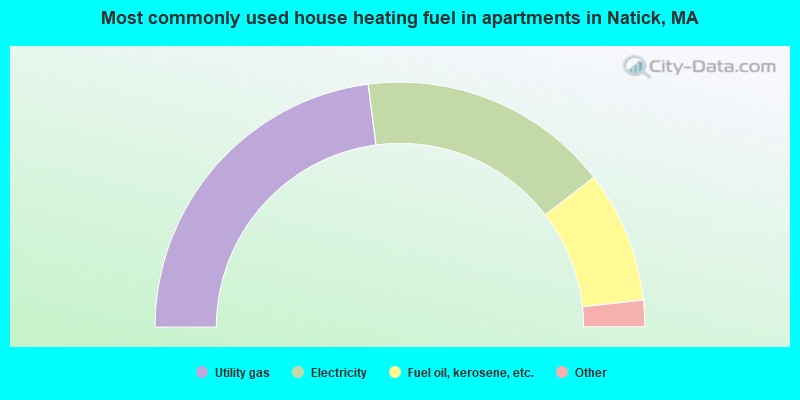
- 45.8%Utility gas
- 33.2%Electricity
- 17.4%Fuel oil, kerosene, etc.
- 2.6%Bottled, tank, or LP gas
- 0.5%No fuel used
- 0.5%Other fuel
Natick compared to Massachusetts state average:
- Unemployed percentage significantly below state average.
- Black race population percentage significantly below state average.
- Hispanic race population percentage significantly below state average.
- Foreign-born population percentage below state average.
- Length of stay since moving in significantly above state average.
- Number of rooms per house significantly below state average.
- House age significantly below state average.
- Percentage of population with a bachelor's degree or higher above state average.
Natick on our top lists:
- #34 on the list of "Top 101 cities with largest percentage of females in industries: radio, tv, and computer stores (population 5,000+)"
- #38 on the list of "Top 101 cities with largest percentage of males in industries: music stores (population 5,000+)"
- #49 on the list of "Top 101 cities with largest percentage of males in occupations: business operations specialists (population 5,000+)"
- #49 on the list of "Top 101 cities with largest percentage of males in industries: radio, tv, and computer stores (population 5,000+)"
- #53 on the list of "Top 101 cities with largest percentage of males in occupations: accountants and auditors (population 5,000+)"
- #54 on the list of "Top 101 cities with largest percentage of females in occupations: top executives (population 5,000+)"
- #55 on the list of "Top 101 cities with largest percentage of females in occupations: computer specialists (population 5,000+)"
- #55 on the list of "Top 101 cities with largest percentage of females in industries: publishing, and motion picture and sound recording industries (population 5,000+)"
- #57 on the list of "Top 101 cities with largest percentage of males in occupations: architects, surveyors, and cartographers (population 5,000+)"
- #62 on the list of "Top 101 cities with largest percentage of males in occupations: computer specialists (population 5,000+)"
- #73 on the list of "Top 101 cities with the most people taking railroad to work (population 5,000+)"
- #86 on the list of "Top 101 cities with largest percentage of females in industries: clothing and accessories, including shoe, stores (population 5,000+)"
- #92 on the list of "Top 101 cities with largest percentage of males in industries: farm product raw materials merchant wholesalers (population 5,000+)"
- #4 on the list of "Top 101 counties with the most Orthodox adherents"
- #7 on the list of "Top 101 counties with the most Catholic adherents"
- #7 on the list of "Top 101 counties with the most Mainline Protestant congregations"
- #7 on the list of "Top 101 counties with the most Orthodox congregations"
- #8 on the list of "Top 101 counties with the lowest percentage of residents that keep firearms around their homes"

|
|
Total of 1746 patent applications in 2008-2024.