Petersham, Massachusetts
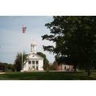
Petersham: Petersham Town Hall
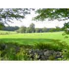
Petersham: Wild Turkeys - Petersham, MA.
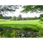
Petersham: Wild Turkeys
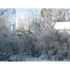
Petersham: Winter Ice Storm
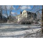
Petersham: Winter Ice Storm
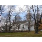
Petersham: Church on th Common at Fall
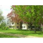
Petersham: House on Petersham Common
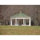
Petersham: Petersham Bandstand on the Common
- add
your
Submit your own pictures of this town and show them to the world
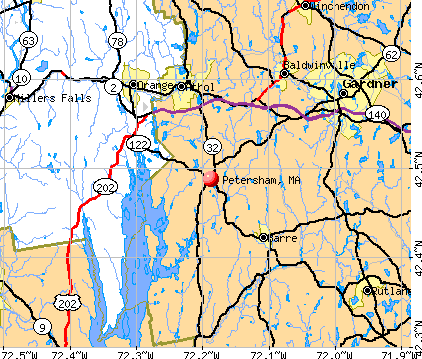
- OSM Map
- General Map
- Google Map
- MSN Map
Population change since 2000: +4.6%
 |
| Males: 631 | |
| Females: 603 |
| Median resident age: | 48.0 years |
| Massachusetts median age: | 39.2 years |
Zip codes: 01366.
| Petersham: | $86,184 |
| MA: | $94,488 |
Estimated per capita income in 2022: $47,228 (it was $24,222 in 2000)
Petersham town income, earnings, and wages data
Estimated median house or condo value in 2022: $419,759 (it was $152,000 in 2000)
| Petersham: | $419,759 |
| MA: | $534,700 |
Mean prices in 2022: all housing units: $419,164; detached houses: $447,621; townhouses or other attached units: $343,592; in 2-unit structures: $323,295; in 3-to-4-unit structures: $332,295; in 5-or-more-unit structures: $232,758; mobile homes: $113,885
Detailed information about poverty and poor residents in Petersham, MA

Compare current foreclosures near Petersham, MA:
| Photo | Address | Area | Beds / Baths | Price | Details |
|---|---|---|---|---|---|

|
#1
East St
Petersham, MA 01366
|
2,732 sq. feet
|
2 baths 6 beds |
show details | |

|
#2
Birch Dr
Petersham, MA 01366
|
1,264 sq. feet
|
2 baths 3 beds |
show details | |

|
#3
N Brookfield Rd
Oakham, MA 01068
|
1,078 sq. feet
|
1 baths 2 beds |
$459,900
|
show details |

|
#4
Parker St
Gardner, MA 01440
|
1,980 sq. feet
|
2 baths 4 beds |
$469,900
|
show details |

|
#5
Hardwick Road
Hardwick, MA 01037
|
- sq. feet
|
1 baths 3 beds |
$244,900
|
show details |

|
#6
Poole Rd
Belchertown, MA 01007
|
800 sq. feet
|
1 baths 2 beds |
show details | |

|
#7
Athol Richmond Rd
Royalston, MA 01368
|
2,000 sq. feet
|
2 baths 3 beds |
show details | |

|
#8
Walnut St
Athol, MA 01331
|
1,600 sq. feet
|
1 baths 2 beds |
show details | |

|
#9
N Orange Rd
Athol, MA 01331
|
950 sq. feet
|
1 baths 3 beds |
show details | |

|
#10
South Street
Ware, MA 01082
|
2,145 sq. feet
|
2 baths 4 beds |
show details |
| Photo | Address | Area | Beds / Baths | Price | Details |
|---|---|---|---|---|---|

|
#11
Grizzly Dr
Rutland, MA 01543
|
- sq. feet
|
2 baths 3 beds |
show details | |

|
#12
Smith Hanson Rd
North Brookfield, MA 01535
|
1,644 sq. feet
|
1 baths 3 beds |
show details | |

|
#13
Church St
Ware, MA 01082
|
2,080 sq. feet
|
1 baths 4 beds |
show details | |

|
#14
Sibley Rd
Winchendon, MA 01475
|
1,728 sq. feet
|
2 baths 3 beds |
show details | |

|
#15
Pearly Ln
Gardner, MA 01440
|
1,728 sq. feet
|
2 baths 4 beds |
show details | |

|
#16
W Main St # 2
Ware, MA 01082
|
1,834 sq. feet
|
2 baths 4 beds |
show details | |

|
#17
Britney Dr
Rutland, MA 01543
|
1,672 sq. feet
|
1 baths 3 beds |
show details | |

|
#18
Pleasant St
Ware, MA 01082
|
2,775 sq. feet
|
1 baths 4 beds |
show details | |

|
#19
Royalston Rd S
Winchendon, MA 01475
|
1,188 sq. feet
|
2 baths 3 beds |
show details | |

|
#20
Church St
Ware, MA 01082
|
3,440 sq. feet
|
3 baths 5 beds |
show details |
| Photo | Address | Area | Beds / Baths | Price | Details |
|---|---|---|---|---|---|

|
#21
Norcross Rd
Royalston, MA 01368
|
1,605 sq. feet
|
3 baths 4 beds |
show details | |

|
#22
Willis Rd
Gardner, MA 01440
|
2,451 sq. feet
|
2 baths 3 beds |
show details | |

|
#23
Grove St
North Brookfield, MA 01535
|
850 sq. feet
|
1 baths 3 beds |
show details | |

|
#24
Winifreds Way
Rutland, MA 01543
|
1,736 sq. feet
|
2 baths 3 beds |
show details | |

|
#25
Bickford Hill Rd
Gardner, MA 01440
|
1,320 sq. feet
|
2 baths 3 beds |
show details | |

|
#26
Tucker Rd
West Brookfield, MA 01585
|
2,240 sq. feet
|
2 baths 3 beds |
show details | |

|
#27
Green St
Gardner, MA 01440
|
3,156 sq. feet
|
2 baths 4 beds |
show details | |

|
#28
Mill Rd
North Brookfield, MA 01535
|
1,026 sq. feet
|
1 baths 4 beds |
show details | |

|
#29
Edgell St
Gardner, MA 01440
|
4,746 sq. feet
|
2 baths 9 beds |
show details | |

|
#30
Lakewood Ter
Gardner, MA 01440
|
3,143 sq. feet
|
4 baths 5 beds |
show details |
| Photo | Address | Area | Beds / Baths | Price | Details |
|---|---|---|---|---|---|

|
#31
Butterworth Rd
Orange, MA 01364
|
896 sq. feet
|
2 baths 2 beds |
show details | |

|
#32
Summer St
Gardner, MA 01440
|
1,893 sq. feet
|
2 baths 5 beds |
show details | |

|
#33
Chelsea St
Gardner, MA 01440
|
1,287 sq. feet
|
1 baths 3 beds |
show details | |

|
#34
Chelsea St
Gardner, MA 01440
|
1,498 sq. feet
|
1 baths 3 beds |
show details | |

|
#35
Pine St
Gardner, MA 01440
|
3,228 sq. feet
|
2 baths 4 beds |
show details | |

|
#36
Stone St
Gardner, MA 01440
|
1,908 sq. feet
|
2 baths 3 beds |
show details | |

|
#37
Chestnut St
North Brookfield, MA 01535
|
2,153 sq. feet
|
2 baths 4 beds |
show details | |

|
#38
Northwest Rd
Spencer, MA 01562
|
1,476 sq. feet
|
1 baths 3 beds |
show details | |

|
#39
Edna Cir
North Brookfield, MA 01535
|
1,231 sq. feet
|
1 baths 2 beds |
show details | |

|
#40
Howard St
Belchertown, MA 01007
|
960 sq. feet
|
1 baths 3 beds |
show details |
| Photo | Address | Area | Beds / Baths | Price | Details |
|---|---|---|---|---|---|

|
#41
School St
Winchendon, MA 01475
|
1,518 sq. feet
|
1 baths 3 beds |
show details | |

|
#42
Spruce St
Winchendon, MA 01475
|
1,504 sq. feet
|
1 baths 3 beds |
show details | |

|
#43
Mill Valley Rd
Belchertown, MA 01007
|
1,596 sq. feet
|
1 baths 3 beds |
show details | |

|
#44
Hamilton St
Belchertown, MA 01007
|
2,189 sq. feet
|
3 baths 4 beds |
show details | |

|
#45
Hadley Path
West Brookfield, MA 01585
|
1,320 sq. feet
|
1 baths 3 beds |
show details | |

|
#46
Nanigian Rd
Paxton, MA 01612
|
1,096 sq. feet
|
1 baths 2 beds |
show details | |

|
#47
Pine St
Amherst, MA 01002
|
2,195 sq. feet
|
2 baths 4 beds |
show details | |

|
#48
Birch St
West Brookfield, MA 01585
|
1,080 sq. feet
|
1 baths 3 beds |
show details | |

|
#49
Wildflower Dr
Amherst, MA 01002
|
2,330 sq. feet
|
2 baths 4 beds |
show details | |

|
Check over 1 million property listings on Foreclosure.com!
|
browse all offers | |||


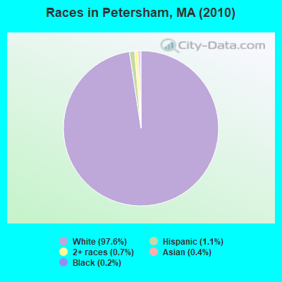
- 1,20497.6%White alone
- 131.1%Hispanic
- 90.7%Two or more races
- 50.4%Asian alone
- 20.2%Black alone
- 10.08%American Indian alone
Races in Petersham detailed stats: ancestries, foreign born residents, place of birth
Full-time law enforcement employees in 2020, including police officers: 2 (2 officers - 2 male; 0 female).
| Officers per 1,000 residents here: | 1.61 |
| Massachusetts average: | 2.59 |
 Recent articles from our blog. Our writers, many of them Ph.D. graduates or candidates, create easy-to-read articles on a wide variety of topics.

 | Hillbilly Massachusetts (103 replies) |
| Quiet, safe town in MA to visit? (24 replies) |
| Let's talk about the Quabbin Reservoir (25 replies) |
| Sand vs salt, Quabbin hill towns. (1 reply) |
| How Would YOU Define the Distinct Areas of Massachusetts? (32 replies) |
| Which Franklin county town for young family? (12 replies) |
Latest news from Petersham, MA collected exclusively by city-data.com from local newspapers, TV, and radio stations
Ancestries: English (26.2%), Irish (19.2%), German (11.8%), French (8.8%), Polish (6.7%), Swedish (5.8%).
Current Local Time: EST time zone
Incorporated in 1754
Elevation: 1080 feet
Land area: 54.2 square miles.
Population density: 23 people per square mile (very low).
62 residents are foreign born (2.5% North America, 2.2% Europe).
| This town: | 5.3% |
| Massachusetts: | 12.2% |
| Petersham town: | 1.1% ($1,681) |
| Massachusetts: | 1.3% ($2,336) |
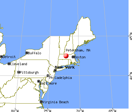
Nearest city with pop. 50,000+: Worcester, MA  (25.3 miles , pop. 172,648).
Nearest city with pop. 200,000+: Boston, MA (58.3 miles , pop. 589,141).
Nearest city with pop. 1,000,000+: Bronx, NY (141.6 miles , pop. 1,332,650).
Nearest cities:
)Latitude: 42.47 N, Longitude: 72.21 W
Area code: 978

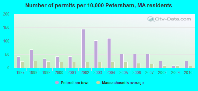
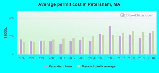
Single-family new house construction building permits:
- 2010: 3 buildings, average cost: $237,400
- 2009: 1 building, cost: $180,000
- 2008: 3 buildings, average cost: $220,200
- 2007: 6 buildings, average cost: $208,100
- 2006: 6 buildings, average cost: $318,300
- 2005: 6 buildings, average cost: $231,900
- 2004: 13 buildings, average cost: $148,800
- 2003: 12 buildings, average cost: $155,400
- 2002: 17 buildings, average cost: $145,300
- 2001: 5 buildings, average cost: $121,400
- 2000: 5 buildings, average cost: $145,000
- 1999: 4 buildings, average cost: $150,000
- 1998: 8 buildings, average cost: $152,000
- 1997: 5 buildings, average cost: $166,400
| Here: | 4.7% |
| Massachusetts: | 3.5% |
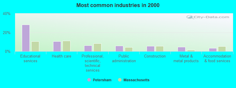
- Educational services (28.3%)
- Health care (10.4%)
- Professional, scientific, technical services (6.2%)
- Public administration (6.0%)
- Construction (5.5%)
- Metal & metal products (4.7%)
- Accommodation & food services (3.4%)
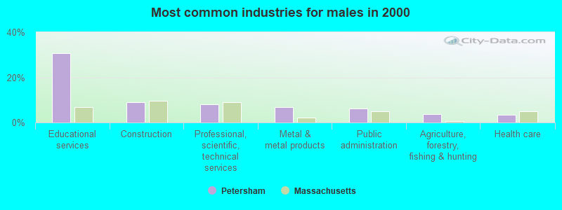
- Educational services (30.7%)
- Construction (8.9%)
- Professional, scientific, technical services (8.0%)
- Metal & metal products (6.7%)
- Public administration (6.1%)
- Agriculture, forestry, fishing & hunting (3.8%)
- Health care (3.5%)
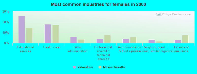
- Educational services (25.7%)
- Health care (18.0%)
- Public administration (6.0%)
- Professional, scientific, technical services (4.2%)
- Accommodation & food services (4.2%)
- Religious, grantmaking, civic, professional, similar organizations (3.5%)
- Finance & insurance (3.2%)

- Life and physical scientists (14.6%)
- Secretaries and administrative assistants (5.4%)
- Other management occupations, except farmers and farm managers (4.7%)
- Other office and administrative support workers, including supervisors (4.2%)
- Preschool, kindergarten, elementary, and middle school teachers (3.7%)
- Postsecondary teachers (3.4%)
- Material recording, scheduling, dispatching, and distributing workers (2.7%)
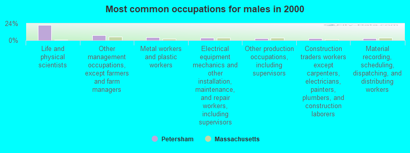
- Life and physical scientists (21.7%)
- Other management occupations, except farmers and farm managers (7.0%)
- Metal workers and plastic workers (4.5%)
- Electrical equipment mechanics and other installation, maintenance, and repair workers, including supervisors (3.5%)
- Other production occupations, including supervisors (3.2%)
- Construction traders workers except carpenters, electricians, painters, plumbers, and construction laborers (2.9%)
- Material recording, scheduling, dispatching, and distributing workers (2.9%)

- Secretaries and administrative assistants (11.3%)
- Other office and administrative support workers, including supervisors (8.5%)
- Life and physical scientists (6.7%)
- Preschool, kindergarten, elementary, and middle school teachers (6.0%)
- Registered nurses (4.9%)
- Nursing, psychiatric, and home health aides (3.9%)
- Postsecondary teachers (3.9%)
Average climate in Petersham, Massachusetts
Based on data reported by over 4,000 weather stations


(lower is better)
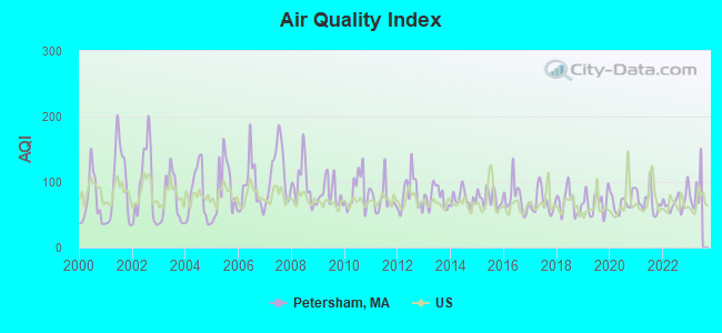
Air Quality Index (AQI) level in 2022 was 69.9. This is about average.
| City: | 69.9 |
| U.S.: | 72.6 |
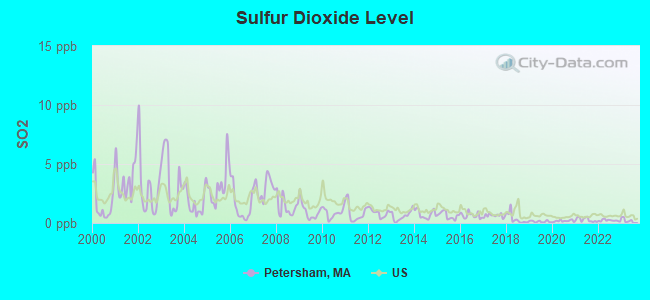
Sulfur Dioxide (SO2) [ppb] level in 2022 was 0.216. This is significantly better than average. Closest monitor was 8.3 miles away from the city center.
| City: | 0.216 |
| U.S.: | 1.515 |
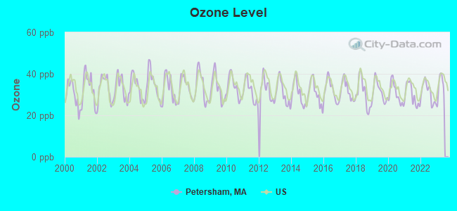
Ozone [ppb] level in 2022 was 30.9. This is about average. Closest monitor was 13.7 miles away from the city center.
| City: | 30.9 |
| U.S.: | 33.3 |
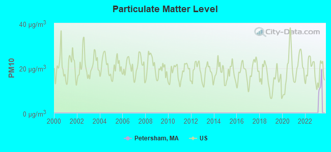
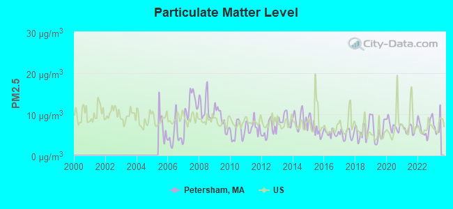
Particulate Matter (PM2.5) [µg/m3] level in 2022 was 6.84. This is about average. Closest monitor was 13.7 miles away from the city center.
| City: | 6.84 |
| U.S.: | 8.11 |
Tornado activity:
Petersham-area historical tornado activity is above Massachusetts state average. It is 11% smaller than the overall U.S. average.
On 6/9/1953, a category F4 (max. wind speeds 207-260 mph) tornado 2.2 miles away from the Petersham town center killed 90 people and injured 1228 people and caused between $50,000,000 and $500,000,000 in damages.
On 6/22/1981, a category F3 (max. wind speeds 158-206 mph) tornado 9.5 miles away from the town center injured 3 people and caused between $5000 and $50,000 in damages.
Earthquake activity:
Petersham-area historical earthquake activity is significantly above Massachusetts state average. It is 70% smaller than the overall U.S. average.On 10/7/1983 at 10:18:46, a magnitude 5.3 (5.1 MB, 5.3 LG, 5.1 ML, Class: Moderate, Intensity: VI - VII) earthquake occurred 148.2 miles away from Petersham center
On 4/20/2002 at 10:50:47, a magnitude 5.3 (5.3 ML, Depth: 3.0 mi) earthquake occurred 159.4 miles away from Petersham center
On 4/20/2002 at 10:50:47, a magnitude 5.2 (5.2 MB, 4.2 MS, 5.2 MW, 5.0 MW) earthquake occurred 158.4 miles away from Petersham center
On 1/19/1982 at 00:14:42, a magnitude 4.7 (4.5 MB, 4.7 MD, 4.5 LG, Class: Light, Intensity: IV - V) earthquake occurred 77.4 miles away from the city center
On 10/16/2012 at 23:12:25, a magnitude 4.7 (4.7 ML, Depth: 10.0 mi) earthquake occurred 110.5 miles away from Petersham center
On 10/2/1994 at 11:27:22, a magnitude 3.7 (3.5 LG, 3.7 LG, Depth: 6.2 mi, Class: Light, Intensity: II - III) earthquake occurred 9.4 miles away from the city center
Magnitude types: regional Lg-wave magnitude (LG), body-wave magnitude (MB), duration magnitude (MD), local magnitude (ML), surface-wave magnitude (MS), moment magnitude (MW)
Natural disasters:
The number of natural disasters in Worcester County (27) is a lot greater than the US average (15).Major Disasters (Presidential) Declared: 15
Emergencies Declared: 12
Causes of natural disasters: Floods: 9, Storms: 8, Hurricanes: 6, Snowstorms: 5, Winter Storms: 4, Blizzards: 2, Snows: 2, Fire: 1, Heavy Rain: 1, Snowfall: 1, Tornado: 1, Wind: 1 (Note: some incidents may be assigned to more than one category).

Hospitals and medical centers near Petersham:
- QUABBIN VALLEY HEALTHCARE (Nursing Home, about 8 miles away; ATHOL, MA)
- ATHOL MEMORIAL HOSPITAL Critical Access Hospitals (about 8 miles away; ATHOL, MA)
- ATHOL MEMORIAL HOME HEALTH AND HOSPICE (Hospital, about 9 miles away; ATHOL, MA)
- TEMPLETON DEVELOPMENTAL CENTER (Hospital, about 10 miles away; BALDWINVILLE, MA)
- BALDWINVILLE NURSING HOME (Nursing Home, about 13 miles away; BALDWINVILLE, MA)
- LEGEND REHABILITATION AND NURSING CENTER (Nursing Home, about 14 miles away; GARDNER, MA)
- WACHUSETT MANOR (Nursing Home, about 14 miles away; GARDNER, MA)
Colleges/universities with over 2000 students nearest to Petersham:
- Mount Wachusett Community College (about 15 miles; Gardner, MA; Full-time enrollment: 3,143)
- University of Massachusetts-Amherst (about 18 miles; Amherst, MA; FT enrollment: 26,583)
- Franklin Pierce University (about 23 miles; Rindge, NH; FT enrollment: 2,139)
- Fitchburg State University (about 23 miles; Fitchburg, MA; FT enrollment: 5,010)
- Assumption College (about 24 miles; Worcester, MA; FT enrollment: 2,580)
- Worcester State University (about 24 miles; Worcester, MA; FT enrollment: 5,426)
- Mount Holyoke College (about 24 miles; South Hadley, MA; FT enrollment: 2,573)
Public elementary/middle school in Petersham:
- PETERSHAM CENTER (Students: 125, Location: 2 SPRING STREET, Grades: KG-6)
Points of interest:
Notable location: Petersham Fire Department (A). Display/hide its location on the map
Churches in Petersham include: Sisters of the Assumption Church (A), Saint Peters Church (B), Petersham Congregational Church (C). Display/hide their locations on the map
Birthplace of: Emmeline B. Wells - General President of the Relief Society, Austin Flint - Physician, Jonas H. Howe - Politician, Solomon Willard - Artist, Jonas Howe - Politician.
| This town: | 2.4 people |
| Massachusetts: | 2.5 people |
| This town: | 69.8% |
| Whole state: | 63.0% |
| This town: | 6.9% |
| Whole state: | 7.0% |
Likely homosexual households (counted as self-reported same-sex unmarried-partner households)
- Lesbian couples: 0.4% of all households
- Gay men: 0.4% of all households
| This town: | 5.8% |
| Whole state: | 9.3% |
| This town: | 3.9% |
| Whole state: | 4.4% |
People in group quarters in Petersham in 2000:
- 69 people in religious group quarters
- 18 people in college dormitories (includes college quarters off campus)
- 6 people in other nonhousehold living situations
For population 15 years and over in Petersham:
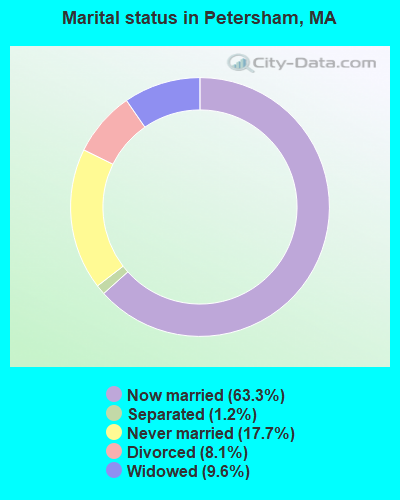
- Never married: 17.7%
- Now married: 63.3%
- Separated: 1.2%
- Widowed: 9.6%
- Divorced: 8.1%
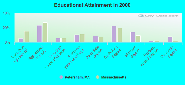
For population 25 years and over in Petersham:
- High school or higher: 94.7%
- Bachelor's degree or higher: 46.0%
- Graduate or professional degree: 23.7%
- Unemployed: 6.6%
- Mean travel time to work (commute): 29.6 minutes
| Here: | 11.1 |
| Massachusetts average: | 13.1 |


Graphs represent county-level data. Detailed 2008 Election Results
Religion statistics for Petersham, MA (based on Worcester County data)


| Religion | Adherents | Congregations |
|---|---|---|
| Catholic | 306,925 | 118 |
| Mainline Protestant | 43,326 | 171 |
| Evangelical Protestant | 37,511 | 203 |
| Other | 18,931 | 69 |
| Orthodox | 7,935 | 15 |
| Black Protestant | 497 | 6 |
| None | 383,427 | - |
Food Environment Statistics:
| This county: | 1.73 / 10,000 pop. |
| Massachusetts: | 1.98 / 10,000 pop. |
| This county: | 0.05 / 10,000 pop. |
| State: | 0.05 / 10,000 pop. |
| This county: | 1.79 / 10,000 pop. |
| State: | 2.22 / 10,000 pop. |
| This county: | 2.22 / 10,000 pop. |
| State: | 1.77 / 10,000 pop. |
| Worcester County: | 7.27 / 10,000 pop. |
| Massachusetts: | 8.76 / 10,000 pop. |
| Here: | 8.0% |
| Massachusetts: | 8.1% |
| This county: | 24.0% |
| State: | 22.5% |
| Here: | 16.6% |
| Massachusetts: | 16.5% |
4.71% of this county's 2021 resident taxpayers lived in other counties in 2020 ($76,229 average adjusted gross income)
| Here: | 4.71% |
| Massachusetts average: | 6.35% |
0.02% of residents moved from foreign countries ($100 average AGI)
Worcester County: 0.02% Massachusetts average: 0.01%
Top counties from which taxpayers relocated into this county between 2020 and 2021:
| from Middlesex County, MA | |
| from Norfolk County, MA | |
| from Suffolk County, MA |
4.84% of this county's 2020 resident taxpayers moved to other counties in 2021 ($87,252 average adjusted gross income)
| Here: | 4.84% |
| Massachusetts average: | 7.18% |
0.03% of residents moved to foreign countries ($199 average AGI)
Worcester County: 0.03% Massachusetts average: 0.02%
Top counties to which taxpayers relocated from this county between 2020 and 2021:
| to Middlesex County, MA | |
| to Norfolk County, MA | |
| to Suffolk County, MA |
Strongest AM radio stations in Petersham:
- WCRN (830 AM; 50 kW; WORCESTER, MA; Owner: CARTER BROADCASTING CORPORATION)
- WVNE (760 AM; daytime; 25 kW; LEICESTER, MA; Owner: BLOUNT MASSCOM, INC.)
- WNNZ (640 AM; 50 kW; WESTFIELD, MA; Owner: CLEAR CHANNEL BROADCASTING LICENSES, INC.)
- WCAT (700 AM; daytime; 2 kW; ORANGE-ATHOL, MA; Owner: CITADEL BROADCASTING COMPANY)
- WRKO (680 AM; 50 kW; BOSTON, MA; Owner: ENTERCOM BOSTON LICENSE, LLC)
- WKOX (1200 AM; 50 kW; FRAMINGHAM, MA; Owner: CAPSTAR TX LIMITED PARTNERSHIP)
- WEEI (850 AM; 50 kW; BOSTON, MA; Owner: ENTERCOM BOSTON LICENSE, LLC)
- WALE (990 AM; 50 kW; GREENVILLE, RI; Owner: NORTH AMERICAN BROADCASTING CO., INC.)
- WBIX (1060 AM; 40 kW; NATICK, MA; Owner: LANGER BROADCASTING CORPORATION)
- WTAG (580 AM; 5 kW; WORCESTER, MA; Owner: CAPSTAR TX LIMITED PARTNERSHIP)
- WARE (1250 AM; 5 kW; WARE, MA; Owner: SUCCESS SIGNAL BROADCASTING, INC.)
- WAMG (890 AM; 25 kW; DEDHAM, MA; Owner: MEGA COMMUNICATIONS OF DEDHAM LICENSEE, LLC)
- WTIC (1080 AM; 50 kW; HARTFORD, CT; Owner: INFINITY RADIO OPERATIONS INC.)
Strongest FM radio stations in Petersham:
- WAHL (99.9 FM; ATHOL, MA; Owner: CITADEL BROADCASTING COMPANY)
- WFCR (88.5 FM; AMHERST, MA; Owner: UNIVERSITY OF MASSACHUSETTS)
- WAMH (89.3 FM; AMHERST, MA; Owner: TRUSTEES OF AMHERST COLLEGE)
- WAAF (107.3 FM; WORCESTER, MA; Owner: ENTERCOM BOSTON LICENSE, LLC)
- WSRS (96.1 FM; WORCESTER, MA; Owner: CAPSTAR TX LIMITED PARTNERSHIP)
- W246AM (97.1 FM; AMHERST, MA; Owner: GREAT NORTHERN RADIO, LLC)
- WFEX (92.1 FM; PETERBOROUGH, NH; Owner: FNX BROADCASTING OF NEW HAMPSHIRE LLC)
- WXLO (104.5 FM; FITCHBURG, MA; Owner: CITADEL BROADCASTING COMPANY)
- WHYN-FM (93.1 FM; SPRINGFIELD, MA; Owner: CLEAR CHANNEL BROADCASTING LICENSES, INC.)
- WJDF (97.3 FM; ORANGE, MA; Owner: DEANE BROTHERS BROADCASTING CORP.)
- WRNX (100.9 FM; AMHERST, MA; Owner: WESTERN MASSACHUSETTS RADIO COMPANY)
- WAMC-FM (90.3 FM; ALBANY, NY; Owner: WAMC)
- WPVQ (95.3 FM; GREENFIELD, MA; Owner: GREAT NORTHERN RADIO, L.L.C.)
- WYRY (104.9 FM; HINSDALE, NH; Owner: TRI-VALLEY BROADCASTING CORPORATION)
- WEQX (102.7 FM; MANCHESTER, VT; Owner: NORTHSHIRE COMMUNICATIONS, INC.)
- WINQ (97.7 FM; WINCHENDON, MA; Owner: SAGA COMMUNICATIONS OF NEW ENGLAND, LLC)
- WJAN (95.1 FM; SUNDERLAND, VT; Owner: 6 JOHNSON ROAD LICENSES, INC.)
- WHDQ (106.1 FM; CLAREMONT, NH; Owner: GREAT NORTHERN RADIO, L.L.C.)
- WVAY (100.7 FM; WILMINGTON, VT; Owner: GREAT NORTHERN RADIO, L.L.C.)
- WOQL (98.7 FM; WINCHESTER, NH; Owner: SAGA COMMUNICATIONS OF NEW HAMPSHIRE, LLC)
TV broadcast stations around Petersham:
- WYDN (Channel 48; WORCESTER, MA; Owner: EDUCATIONAL PUBLIC TV CORPORATION)
- WUNI (Channel 27; WORCESTER, MA; Owner: ENTRAVISION HOLDINGS, LLC)
- WUTF (Channel 66; MARLBOROUGH, MA; Owner: TELEFUTURA BOSTON LLC)
- WCRN-LP (Channel 34; LEICESTER, MA; Owner: CARTER BROADCASTING CORPORATION)
- Petersham, Massachusetts
- Fatal accident count11
- Vehicles involved in fatal accidents17
- Fatal accidents involving drunk persons:6
- Fatalities16
- Persons involved in fatal accidents33
- Pedestrians involved in fatal accidents0
- Massachusetts average
- Fatal accident count4781
- Vehicles involved in fatal accidents6605
- Fatal accidents involving drunk persons1444
- Fatalities5183
- Persons involved in fatal accidents11318
- Pedestrians involved in fatal accidents515
- National Bridge Inventory (NBI) Statistics
- 4Number of bridges
- 20ft / 6.1mTotal length
- $2,811,000Total costs
- 4,359Total average daily traffic
- 303Total average daily truck traffic
- 6,884Total future (year 2031) average daily traffic
FCC Registered Antenna Towers:
6- Stephanie Betts, 0.17nm East Of The Intersection Of Quaker Dr And Hall (Lat: 42.478639 Lon: -72.149472), Type: 48.8, Structure height: 25027 m, Overall height: 48.8 m, Registrant: Towernorth Development, LLC, Bstern@clinellc.Com, Suite 1, Raynh-am, Phone: (215) 803-4858
- Stephanie Betts, 0.17nm East Of The Intersection Of Quaker Dr And Hall (Lat: 42.478639 Lon: -72.149472), Type: 48.8, Structure height: 25027 m, Overall height: 48.8 m, Registrant: Towernorth Development, LLC, Bstern@clinellc.Com, Suite 1, Raynh-am, Phone: (215) 803-4858
- James Walker, 0.17nm East Of The Intersection Of Quaker Dr And Hall (Lat: 42.478639 Lon: -72.149472), Type: 48.8, Structure height: 25027 m, Overall height: 48.8 m, Registrant: Towernorth Development, LLC, Bstern@clinellc.Com, , West -Bridgewater, Phone: (215) 803-4858
- Cody Carter, 0.17nm East Of The Intersection Of Quaker Dr And Hall (Lat: 42.478639 Lon: -72.149472), Type: 48.8, Structure height: 25027 m, Overall height: 48.8 m, Registrant: Towernorth Development, LLC, Bstern@clinellc.Com, , West -Bridgewater, Phone: (215) 803-4858
- Cody J Carter, 0.17nm East Of The Intersection Of Quaker Dr And Hall (Lat: 42.478639 Lon: -72.149472), Type: 43.0, Structure height: 25027 m, Overall height: 43 m, Registrant: Towernorth Development, LLC, Bstern@clinellc.Com, , West -Bridgewater, Phone: (215) 803-4858
- Cody Carter, 0.17nm East Of The Intersection Of Quaker Dr And Hall (Lat: 42.478639 Lon: -72.149472), Type: 43.0, Structure height: 25027 m, Overall height: 43 m, Registrant: Towernorth Development, LLC, Bstern@clinellc.Com, , West -Bridgewater, Phone: (215) 803-4858
FCC Registered Broadcast Land Mobile Towers:
4- Town Hall Main St (Lat: 42.488139 Lon: -72.186194), Call Sign: KNED288,
Assigned Frequencies: 151.040 MHz, Grant Date: 08/09/2022, Expiration Date: 10/28/2032, Registrant: Petersham Fire Dept, 3 South Main Street, Petersham, MA 01366, Phone: (978) 724-3211, Email:
- Bombing Tower (Lat: 42.480639 Lon: -72.275917), Call Sign: KCB370, Licensee ID: L00003516,
Assigned Frequencies: 39.5800 MHz, Grant Date: 07/10/2015, Expiration Date: 10/05/2025, Registrant: Massachusetts Commonwealth Of, Department Of State Police, 470 Worcester Rd, Framingham, MA 01702, Phone: (508) 820-2222, Fax: (774) 462-3768, Email:
- Town Hall Main St (Lat: 42.493694 Lon: -72.185639), Type: Building, Structure height: 12 m, Overall height: 15 m, Call Sign: WPIZ327,
Assigned Frequencies: 39.7600 MHz, Grant Date: 09/22/2015, Expiration Date: 12/08/2025, Certifier: Lt Thomas Walsh, Registrant: Massachusetts, Commonwealth Of, 470 Worcester Rd, Framingham, MA 01702, Phone: (508) 820-2264, Email:
- Lat: 42.483750 Lon: -72.192444, Call Sign: WPWV560, Licensee ID: L00038283,
Assigned Frequencies: 72.1000 MHz, Grant Date: 12/06/2022, Expiration Date: 01/24/2033, Certifier: Rebecca Phillips, Registrant: Petersham Center School
FCC Registered Microwave Towers:
1- Petersham SP, 41 Hall Road (Lat: 42.478639 Lon: -72.149472), Type: Mtower, Structure height: 43 m, Call Sign: WRPR364,
Assigned Frequencies: 11385.0 MHz, Grant Date: 03/08/2022, Expiration Date: 03/08/2032, Certifier: Cecil J Mathew, Registrant: At&t Services, Inc., 208 S Akard St, 20f, Dallas, TX 75202, Phone: (855) 699-7073, Email:
FCC Registered Amateur Radio Licenses:
6- Call Sign: KA1DWM, Licensee ID: L00676347, Grant Date: 07/18/2023, Expiration Date: 09/21/2033, Registrant: Robert F Laford, 276 West Rd, Petersham, MA 01366
- Call Sign: KA1XR, Licensee ID: L01282240, Grant Date: 08/23/2017, Expiration Date: 11/19/2027, Registrant: Wesley F Laford, 276 West Road, Petersham, MA 01366
- Call Sign: KB1ESS, Licensee ID: L00186624, Grant Date: 09/23/2009, Expiration Date: 12/21/2019, Cancellation Date: 12/22/2021, Certifier: Mark H Hager, Registrant: Mark H Hager, Petersham, MA 01366
- Call Sign: KC1ETL, Licensee ID: L01987678, Grant Date: 12/03/2015, Expiration Date: 12/03/2025, Certifier: Ellen H Anderson, Registrant: Ellen H Anderson, 20 Dana Road, Petersham, MA 01366
- Call Sign: KC1OKK, Licensee ID: L02015862, Grant Date: 01/08/2021, Expiration Date: 01/08/2031, Cancellation Date: 01/09/2024, Certifier: Thomas Jahl, Registrant: Thomas Jahl, Petersham, MA 01366-0126
- Call Sign: K1SVF, Previous Call Sign: KC1OKK, Licensee ID: L02015862, Grant Date: 01/09/2024, Expiration Date: 01/09/2034, Certifier: Thomas V Jahl, Registrant: Thomas Jahl, Petersham, MA 01366-0126
FAA Registered Aircraft:
3- Aircraft: CESSNA 172K (Category: Land, Seats: 4, Weight: Up to 12,499 Pounds, Speed: 105 mph), Engine: LYCOMING 0-320 SERIES (180 HP) (4 Cycle)
N-Number: 7160G, N7160G, N-7160G, Serial Number: 17258860, Year manufactured: 1969, Airworthiness Date: 11/19/1969, Certificate Issue Date: 09/12/1990
Registrant (Individual): Noel F Fisher, 42 New Athol Rd, Petersham, MA 01366 - Aircraft: BUCKEYE AVIATION DREAM MACHINE (Category: Land, Seats: 2, Weight: Up to 12,499 Pounds), Engine: ROTAX 582SER (65 HP) (2 Cycle)
N-Number: 9080G, N9080G, N-9080G, Serial Number: 4851, Year manufactured: 2000, Airworthiness Date: 02/27/2007, Certificate Issue Date: 11/21/2019
Registrant (Individual): Kevin R Shortis, Po Box 154, Petersham, MA 01366 - Aircraft: ENNIS JOHN S CHALLENGER II (Category: Land, Seats: 2, Weight: Up to 12,499 Pounds), Engine: ROTAX 503 DCDI (52 HP) (2 Cycle)
N-Number: 607E, N607E, N-607E, Serial Number: CH2-0607-W-2803, Year manufactured: 2008, Airworthiness Date: 04/16/2009
Registrant (Individual): Reported Sale, 3 Old Hardwick Rd, Petersham, MA 01366
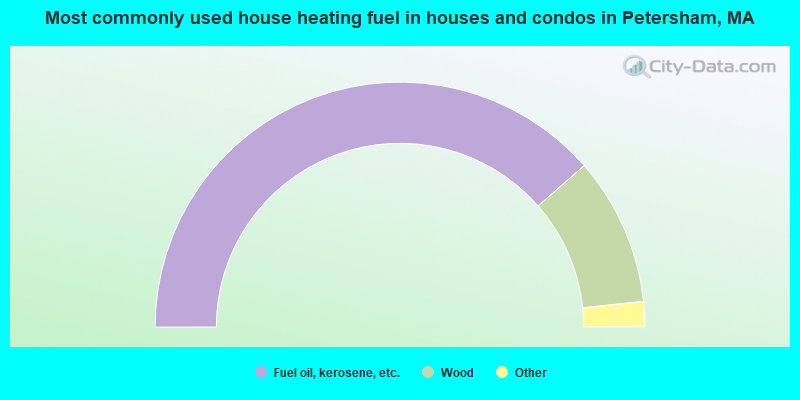
- 77.1%Fuel oil, kerosene, etc.
- 19.6%Wood
- 1.7%Bottled, tank, or LP gas
- 1.1%Electricity
- 0.6%Utility gas
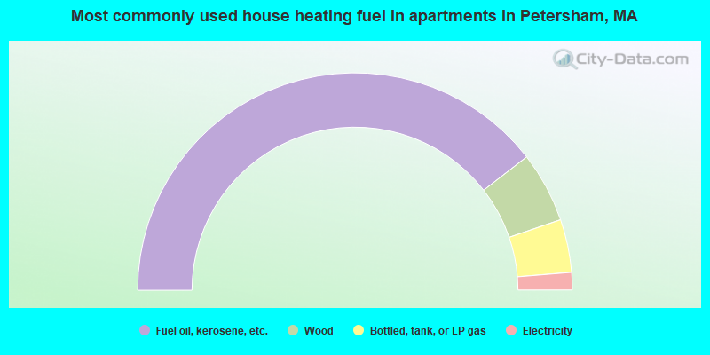
- 78.9%Fuel oil, kerosene, etc.
- 10.5%Wood
- 7.9%Bottled, tank, or LP gas
- 2.6%Electricity
Petersham compared to Massachusetts state average:
- Unemployed percentage below state average.
- Black race population percentage significantly below state average.
- Hispanic race population percentage significantly below state average.
- Median age significantly above state average.
- Foreign-born population percentage significantly below state average.
- Renting percentage significantly below state average.
- Length of stay since moving in significantly above state average.
- Number of rooms per house significantly below state average.
- House age significantly below state average.
Petersham on our top lists:
- #6 on the list of "Top 101 cities with the largest percentage of people in religious group quarters (population 1,000+)"
- #4 on the list of "Top 101 counties with the highest carbon monoxide air pollution readings in 2012 (ppm)"
- #5 on the list of "Top 101 counties with the most Catholic congregations"
- #12 on the list of "Top 101 counties with the highest surface withdrawal of fresh water for public supply"
- #16 on the list of "Top 101 counties with the highest total withdrawal of fresh water for public supply"
- #23 on the list of "Top 101 counties with the highest Sulfur Oxides Annual air pollution readings in 2012 (µg/m3)"

|
|
Total of 70 patent applications in 2008-2024.