Please register to participate in our discussions with 2 million other members - it's free and quick! Some forums can only be seen by registered members. After you create your account, you'll be able to customize options and access all our 15,000 new posts/day with fewer ads.
When is the cold front forecast to come? Looks like overnight by the models, only reason it's cooler is the clouds are preventing heating.
Would you believe that last week the models had the front coming through yesterday? Then as time went on they all slowed the progression of it. Should pass through New England tonight but I personally think it's slower than we think so maybe tomorrow now. So storms would be ahead of it.
A look at the 850mb level dewpoints as the 2 fronts drop down and the 1020mb High in Canada also. VERY dry over Iowa right now.
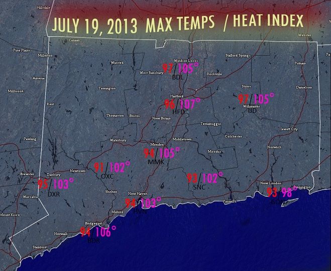
You guys just gave me the idea to plot out the max heat index for our area. Might take some time but thanks for the idea. I think it would be nice to have a graphic and record of what this past heat wave was more about.
...STRONG TO SEVERE THUNDERSTORMS ARE POSSIBLE THIS AFTERNOON AND
EVENING ACROSS THE REGION...
A COLD FRONT WILL APPROACH THE REGION THIS AFTERNOON...BRINGING
SCATTERED SHOWERS AND THUNDERSTORMS. SOME OF THE THUNDERSTORMS
MAY PRODUCE LOCALIZED DAMAGING WINDS. THERE MAY ALSO BE SOME
LOCALIZED FLOODING FROM ANY SHOWER OR THUNDERSTORM. ANY
THUNDERSTORM MAY ALSO PRODUCE FREQUENT CLOUD TO GROUND LIGHTNING.
Took time to do..here's just in CT.. I saved other locations around the area so maybe I'll tackle them too.
Nice map. But I cant believe it was only 91 at the OXC station. Even coastal areas were a few degrees warmer.
Please register to post and access all features of our very popular forum. It is free and quick. Over $68,000 in prizes has already been given out to active posters on our forum. Additional giveaways are planned.
Detailed information about all U.S. cities, counties, and zip codes on our site: City-data.com.

 Please register to participate in our discussions with 2 million other members - it's free and quick! Some forums can only be seen by registered members. After you create your account, you'll be able to customize options and access all our 15,000 new posts/day with fewer ads.