Please register to participate in our discussions with 2 million other members - it's free and quick! Some forums can only be seen by registered members. After you create your account, you'll be able to customize options and access all our 15,000 new posts/day with fewer ads.
Not even close. Utsjoki Kevo in Finland 30 minutes north of Norilsk has recorded 32.9C, and a location in Norway at 70N has recorded a 90F day.
C Burt updated the post:
"Hottest temperatures ever measured so far north?
According to OGIMET the temperature reached 34.0°C (93.2°F) at Snezhnogorsk and Igarka on July 21st , both sites just a bit south of Norilsk. Snezhnogorsk is located at 68° 6'N and 87° 46'E and Igarka at 67° 28'N, 86° 34'E. These sites are just a bit south of the latitude of Umiat, Alaska (at 69° 22' N) where a maximum of 92°F (33.3°C) has been recorded in the past. There is a temperature reading of 36.7°C (98.1°F) in July 1979 reported from Hatanga, Russia which rests at 71° 58'N (about 400 miles northeast of Norilesk). This is a very anomalous reading and may have been the result of a foen-like wind event (down sloping wind heated by compression, like Santa Ana winds in the U.S.). IF the figure is accurate, then this would be, by far, the warmest temperature ever measured on earth at such a northerly latitude.
This Russian Arctic heat wave is still on going and I’ll post updates if necessary."
* at 718 PM EDT... National Weather Service Doppler radar indicated
a line of strengthening thunderstorms capable of producing small
hail... and very heavy rain. These storms were located along a
line extending from 10 miles north of Youngstown to Youngstown to
13 miles west of Lewiston to 25 miles west of Niagara Falls... and
moving east at 25 mph.
These storms have the potential to become severe and produce large
hail and/or damaging winds.
If on or near the lower Niagara River or Lake Ontario... seek shelter
now. Boaters should return to port and get off the water. Move
indoors or inside a vehicle."
88°F to 73° in half hour.
Dewpoints rose to 76° right after storm.
Nice graph, here's Paris-Montsouris' from yesterday (hourly and no dew point sadly). Rh rose from 33% to 90%, dew point from 55°F to 68°F and temp dropped from 90°F to 71°F. The low occured around 3 pm.
TONIGHT...WE EXPECT THE COOLEST TEMPERATURES IN SEVERAL WEEKS TO OCCUR TONIGHT...SINCE AROUND JUNE 20TH. HAVE GENERALLY FORECAST MINS CLOSE TO THE MAV MOS...WITH WIDESPREAD LOWER TO MID 50S WITHIN THE HUDSON VALLEY FROM ALBANY SOUTH...WITH 45-50 TO THE NORTH...AND ACROSS THE MOHAWK VALLEY. MEANWHILE...EXPECT LOWER/MID 40S TO OCCUR ACROSS PORTIONS OF THE SOUTHERN ADIRONDACKS...AND HIGHER ELEVATIONS ACROSS SOUTHERN VT AND WESTERN MA. SOME PATCHY FOG COULD DEVELOP NEAR SOME LAKES/RIVERS/SWAMPY AREAS...WHICH WILL BE QUITE WARM COMPARED TO THE COOL AMBIENT TEMPS
NWS New York, NY needs to take some clues from BTV on how to write a forecast discussion!
AS OF 408 AM EDT WEDNESDAY...OUTSTANDING STRETCH OF WEATHER EXPECTEDFOR THE REMAINDER OF THE SHORT TERM AS CANADIAN HIGH PRESSUREBUILDS EASTWARD INTO THE REGION TONIGHT THROUGH THURSDAY...ANDTHEN RETREATS INTO EASTERN QUEBEC FRIDAY. DRY WEATHER THROUGH THEPERIOD...WITH MAINLY CLEAR SKIES TONIGHT THROUGH THURSDAYNIGHT...FOLLOWED BY A BIT MORE CLOUDINESS ON FRIDAY.TEMPERATURES WILL BE BELOW NORMAL THURSDAY WITH HIGHS MAINLY INTHE LOWER TO MID 70S. THEY WILL RETURN TO SEASONABLE LEVELS FRIDAYWITH VALLEY HIGHS AROUND 80. LOWS BOTH NIGHTS WILL BE QUITECOOL IN THE 40S TO AROUND 50. EXCEPTIONS WILL BE IN THE MOUNTAINVALLEYS WHERE THERE WILL BE SOME 30S...AND ALONG THE LAKE CHAMPLAINSHORELINE WHERE IT WILL BE MILDER DUE TO THE WARM LAKE TEMPS WHICHARE CURRENTLY IN THE LOWER 70S. PATCHY FOG ALSO A GOOD BET...ESPECIALLY TONIGHT AS SOIL MOISTURE LEVELS STILL QUITE HIGH
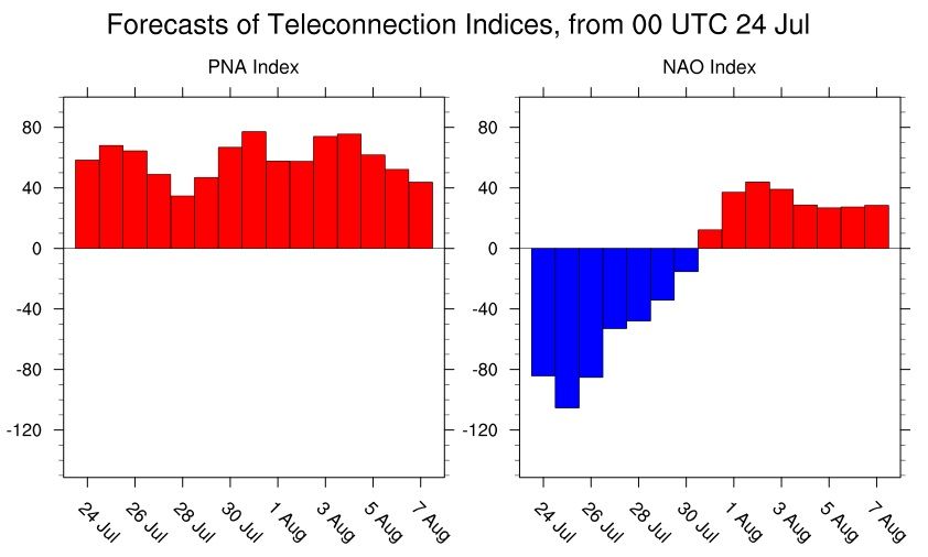
Positive PNA, negative NAO = Seasonable/Cooler Eastern U.S. If we get that tropical storm to head up the coast and into the northern Atlantic than chances are the NAO will stay negative in the long run as well.
Please register to post and access all features of our very popular forum. It is free and quick. Over $68,000 in prizes has already been given out to active posters on our forum. Additional giveaways are planned.
Detailed information about all U.S. cities, counties, and zip codes on our site: City-data.com.

 Please register to participate in our discussions with 2 million other members - it's free and quick! Some forums can only be seen by registered members. After you create your account, you'll be able to customize options and access all our 15,000 new posts/day with fewer ads.