Please register to participate in our discussions with 2 million other members - it's free and quick! Some forums can only be seen by registered members. After you create your account, you'll be able to customize options and access all our 15,000 new posts/day with fewer ads.
Yeah the Chicago area has been about 2-3 degrees below normal so far this month. More in other parts of Illinois... Not as dramatic as the Northeast. We should turn it around and possibly post a surplus by the end of the month.
Midway's mean thus far is 72.0F normal is 74.4F. O'Hare is at 70.2F, normal being 72.3F
Overall I don't think I could consider this summer to have been really good overall. June sucked, August has been pretty boring and pathetically cloudy since the first 3 days, only July really gave us proper summery weather.
Yeah better than the last few summers for sure, as in drier and sunnier. But still one nice month does not a great summer make.
The summer here is not over yet, but what we've had is above average, which seems to be a normal thing lately (every July since 2005 and every August since 2006 were above the average). Each month had a heatwave and each time it got warmer than the past one (36.2c in June, 37.9c in July and 38.1c in August for now).
Even though the summer of 2012 was a bit warmer, I'd rather have it because it at least had its fair share of days below 25c.
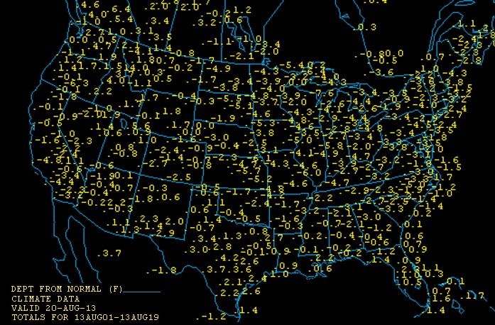
All match the map above showing 2-3 below normal for NYC. They dont just paint the colors. They grab the actual data and it gets plotted on the map.
Thats a huge area of NorthEast ranging from 3-4 below normal so far. Pretty impressive. Kinda shows it wasnt local or because of rain. Thats a strong long lasting airmass that did it.
The dry pattern current underway represents a sea change from the wet weather regime with which we entered meteorological Summer 2013. From the wettest year to date total on record--which is how we came into summer--the period since July 1 ranks the 15th driest on record. And we're not alone. The dry weather reaches into nearly every corner of the nation's Corn Belt, as you can see from this moisture analysis out of the High Plains Climate Center. This is a depiction of the % of normal rainfall which has occurred since July 1 over the country. While Chicago's seen just 3.24" of rain since July's open, the meteorological summer season's produced 41.73" to date in Pensacola, Florida. The Southeast and South are awash in moisture!
Here's a blow-up of the % of normal rainfall since July 1 across the Midwest out of the High Plains Regional Climate Center
The Twin Cities are going to see some good heat in the coming days
All match the map above showing 2-3 below normal for NYC. They dont just paint the colors. They grab the actual data and it gets plotted on the map.
Thats a huge area of NorthEast ranging from 3-4 below normal so far. Pretty impressive. Kinda shows it wasnt local or because of rain. Thats a strong long lasting airmass that did it.
My numbers are correct, the difference is that I compared LaGuardia's current averages to the month of August as a whole, just a different way of looking at it. And by dramatic, I meant the actual map looked dramatic, the use of pinks and purples make it appear significantly below average, to me at least.
Please register to post and access all features of our very popular forum. It is free and quick. Over $68,000 in prizes has already been given out to active posters on our forum. Additional giveaways are planned.
Detailed information about all U.S. cities, counties, and zip codes on our site: City-data.com.

 Please register to participate in our discussions with 2 million other members - it's free and quick! Some forums can only be seen by registered members. After you create your account, you'll be able to customize options and access all our 15,000 new posts/day with fewer ads.