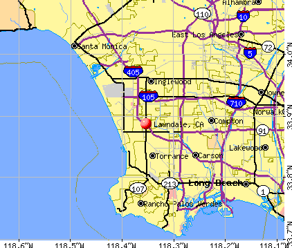
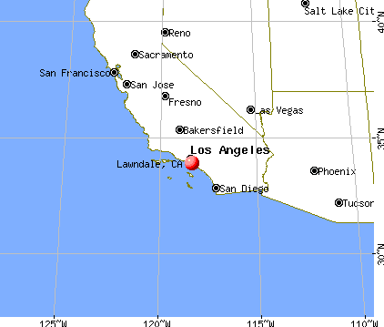
Lawndale, California
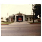
Lawndale: Lawndale Fire Dept.Late 1970's- Early 1980's
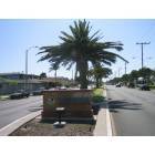
Lawndale: Entrance to Lawndale on Manhattan Beach Blvd.
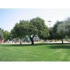
Lawndale: The Alondra Park Playground
- add
your
Submit your own pictures of this city and show them to the world
- OSM Map
- General Map
- Google Map
- MSN Map
Population change since 2000: -3.6%
 |
| Males: 16,083 | |
| Females: 14,493 |
| Median resident age: | 36.2 years |
| California median age: | 37.9 years |
Zip codes: 90260.
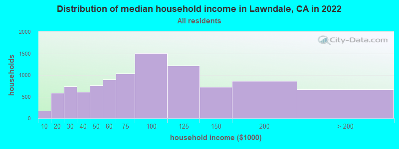
| Lawndale: | $75,395 |
| CA: | $91,551 |
Estimated per capita income in 2022: $30,258 (it was $13,702 in 2000)
Lawndale city income, earnings, and wages data
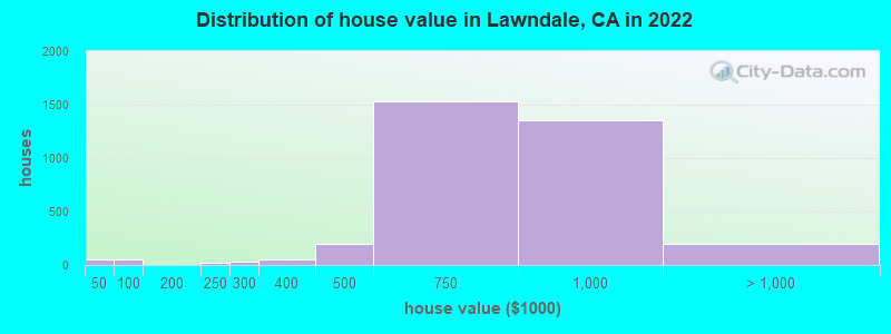
Estimated median house or condo value in 2022: $756,089 (it was $175,500 in 2000)
| Lawndale: | $756,089 |
| CA: | $715,900 |
Mean prices in 2022: all housing units: $757,505; detached houses: $825,902; townhouses or other attached units: $786,088; in 2-unit structures: $836,625; in 3-to-4-unit structures: over $1,000,000; in 5-or-more-unit structures: $474,320; mobile homes: $68,647
Median gross rent in 2022: $1,771.
(8.3% for White Non-Hispanic residents, 18.6% for Black residents, 10.8% for Hispanic or Latino residents, 52.8% for Native Hawaiian and other Pacific Islander residents, 12.3% for other race residents, 9.2% for two or more races residents)
Detailed information about poverty and poor residents in Lawndale, CA


Compare current foreclosures near Lawndale, CA:
| Photo | Address | Area | Beds / Baths | Price | Details |
|---|---|---|---|---|---|

|
#1
W 160th St
Lawndale, CA 90260
|
922 sq. feet
|
4 baths 5 beds |
show details | |

|
#2
W 156th St
Lawndale, CA 90260
|
1,232 sq. feet
|
1 baths 2 beds |
show details | |

|
#3
1/2 W 154th St
Lawndale, CA 90260
|
1,817 sq. feet
|
9 baths 9 beds |
show details | |

|
#4
W 145th St Unit 1
Lawndale, CA 90260
|
1,395 sq. feet
|
3 baths 3 beds |
show details | |

|
#5
W 161st St
Lawndale, CA 90260
|
1,128 sq. feet
|
2 baths 4 beds |
show details | |

|
#6
W 160th St
Lawndale, CA 90260
|
822 sq. feet
|
2 baths 5 beds |
show details | |

|
#7
W 160th St
Lawndale, CA 90260
|
1,156 sq. feet
|
4 baths 6 beds |
show details | |

|
#8
W 171st St
Lawndale, CA 90260
|
996 sq. feet
|
1 baths 3 beds |
show details | |

|
#9
W 154th St
Lawndale, CA 90260
|
- sq. feet
|
- baths - beds |
show details | |

|
#10
W 159th St
Lawndale, CA 90260
|
- sq. feet
|
- baths - beds |
show details |
| Photo | Address | Area | Beds / Baths | Price | Details |
|---|---|---|---|---|---|

|
#11
Artesia Blvd
Lawndale, CA 90260
|
- sq. feet
|
- baths - beds |
show details | |

|
#12
Osage Ave
Lawndale, CA 90260
|
- sq. feet
|
- baths - beds |
show details | |

|
#13
W 167th St
Lawndale, CA 90260
|
- sq. feet
|
- baths - beds |
show details | |

|
#14
W 166th St
Lawndale, CA 90260
|
- sq. feet
|
- baths - beds |
show details | |

|
#15
Horn Ave Apt 618
West Hollywood, CA 90069
|
797 sq. feet
|
1 baths 1 beds |
$650,000
|
show details |

|
#16
Flicker Way
West Hollywood, CA 90069
|
1,612 sq. feet
|
3 baths 3 beds |
$2,195,500
|
show details |

|
#17
Cedarbrook Dr
Beverly Hills, CA 90210
|
2,371 sq. feet
|
2 baths 3 beds |
$2,350,000
|
show details |

|
#18
Aberdeen Ave
Los Angeles, CA 90027
|
6,957 sq. feet
|
4 baths 6 beds |
$5,040,000
|
show details |

|
#19
Wilshire Blvd Apt 703
Los Angeles, CA 90024
|
2,245 sq. feet
|
2 baths 2 beds |
$1,750,000
|
show details |

|
#20
1238 S Redondo Blvd
Los Angeles, CA 90019
|
- sq. feet
|
2 baths 4 beds |
$849,900
|
show details |
| Photo | Address | Area | Beds / Baths | Price | Details |
|---|---|---|---|---|---|

|
#21
6th Ave
Venice, CA 90291
|
3,192 sq. feet
|
3 baths 6 beds |
show details | |

|
#22
E 60th St
Los Angeles, CA 90001
|
1,883 sq. feet
|
3 baths 5 beds |
show details | |

|
#23
W 110th St
Inglewood, CA 90303
|
3,481 sq. feet
|
4 baths 6 beds |
show details | |

|
#24
N Beachwood Dr
Los Angeles, CA 90068
|
1,848 sq. feet
|
2 baths 2 beds |
show details | |

|
#25
Mira Mar Ave
Long Beach, CA 90814
|
1,902 sq. feet
|
2 baths 4 beds |
show details | |

|
#26
And 6111 Northside Drive
Los Angeles, CA 90022
|
1,329 sq. feet
|
4 baths 3 beds |
show details | |

|
#27
Marina City Dr Unit 116
Marina Del Rey, CA 90292
|
1,722 sq. feet
|
2 baths 3 beds |
show details | |

|
#28
W Arbor St # 57
Long Beach, CA 90805
|
1,585 sq. feet
|
2 baths 3 beds |
show details | |

|
#29
Elburg St Unit A
Paramount, CA 90723
|
1,131 sq. feet
|
2 baths 3 beds |
show details | |

|
#30
Bohlig Rd Apt 45
Los Angeles, CA 90032
|
813 sq. feet
|
2 baths 2 beds |
show details |
| Photo | Address | Area | Beds / Baths | Price | Details |
|---|---|---|---|---|---|

|
#31
N Commonwealth Ave
Los Angeles, CA 90004
|
3,937 sq. feet
|
6 baths 6 beds |
show details | |

|
#32
Dunrobin Ave
Downey, CA 90242
|
3,000 sq. feet
|
4 baths 8 beds |
show details | |

|
#33
Norwalk Blvd Apt
Hawaiian Gardens, CA 90716
|
800 sq. feet
|
2 baths 1 beds |
show details | |

|
#34
Redondo Avenue, Units 5-8
Long Beach, CA 90804
|
3,360 sq. feet
|
4 baths 8 beds |
show details | |

|
#35
Walnut Dr
Los Angeles, CA 90001
|
944 sq. feet
|
1 baths 3 beds |
show details | |

|
#36
Maie Ave
Los Angeles, CA 90001
|
860 sq. feet
|
1 baths 2 beds |
show details | |

|
#37
Holmes Ave
Los Angeles, CA 90001
|
1,129 sq. feet
|
2 baths 4 beds |
show details | |

|
#38
Palm Ave
Lynwood, CA 90262
|
1,454 sq. feet
|
2 baths 2 beds |
show details | |

|
#39
E 92nd St
Los Angeles, CA 90002
|
2,290 sq. feet
|
2 baths 4 beds |
show details | |

|
#40
20th Ave
Venice, CA 90291
|
1,564 sq. feet
|
3 baths 3 beds |
show details |
| Photo | Address | Area | Beds / Baths | Price | Details |
|---|---|---|---|---|---|

|
#41
Cedar Ave
Lynwood, CA 90262
|
1,092 sq. feet
|
2 baths 3 beds |
show details | |

|
#42
Santa Fe Ave
Lynwood, CA 90262
|
1,124 sq. feet
|
2 baths 3 beds |
show details | |

|
#43
E 91st St
Los Angeles, CA 90002
|
1,694 sq. feet
|
2 baths 5 beds |
show details | |

|
#44
Stevens Ave
Culver City, CA 90230
|
1,638 sq. feet
|
2 baths 4 beds |
show details | |

|
#45
5th Ave
Los Angeles, CA 90043
|
1,315 sq. feet
|
2 baths 3 beds |
show details | |

|
#46
S Gramercy Pl
Los Angeles, CA 90062
|
- sq. feet
|
2 baths 4 beds |
show details | |

|
#47
4th Ave
Los Angeles, CA 90008
|
1,265 sq. feet
|
1 baths 2 beds |
show details | |

|
#48
Don Ricardo Dr Apt 20
Los Angeles, CA 90008
|
641 sq. feet
|
1 baths 1 beds |
show details | |

|
#49
Olmsted Ave
Los Angeles, CA 90008
|
1,550 sq. feet
|
2 baths 3 beds |
show details | |

|
Check over 1 million property listings on Foreclosure.com!
|
browse all offers | |||


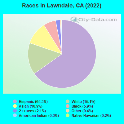
- 20,15065.3%Hispanic
- 4,66715.1%White alone
- 3,37110.9%Asian alone
- 1,8355.9%Black alone
- 6602.1%Two or more races
- 1110.4%Other race alone
- 800.3%American Indian alone
- 540.2%Native Hawaiian and Other
Pacific Islander alone
According to our research of California and other state lists, there were 35 registered sex offenders living in Lawndale, California as of April 29, 2024.
The ratio of all residents to sex offenders in Lawndale is 955 to 1.
The ratio of registered sex offenders to all residents in this city is lower than the state average.
Type |
2009 |
2010 |
2011 |
2012 |
2013 |
2014 |
2015 |
2016 |
2017 |
2018 |
2019 |
2020 |
2022 |
|---|---|---|---|---|---|---|---|---|---|---|---|---|---|
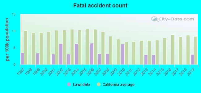
| Murders (per 100,000) | 1 (3.2) | 4 (12.2) | 5 (15.1) | 2 (6.0) | 1 (3.0) | 0 (0.0) | 0 (0.0) | 0 (0.0) | 2 (6.0) | 3 (9.1) | 1 (3.1) | 1 (3.1) | 1 (3.3) |
| Rapes (per 100,000) | 5 (16.0) | 10 (30.5) | 7 (21.1) | 4 (12.0) | 9 (27.1) | 6 (18.0) | 9 (26.8) | 9 (26.8) | 3 (9.0) | 10 (30.2) | 6 (18.3) | 6 (18.5) | 10 (32.8) |
| Robberies (per 100,000) | 82 (262.0) | 67 (204.5) | 72 (217.2) | 51 (153.1) | 51 (153.5) | 49 (147.0) | 62 (184.5) | 71 (211.6) | 66 (198.8) | 30 (90.6) | 40 (122.1) | 50 (154.6) | 28 (91.9) |
| Assaults (per 100,000) | 85 (271.6) | 147 (448.6) | 91 (274.5) | 110 (330.2) | 101 (303.9) | 102 (305.9) | 125 (372.0) | 114 (339.7) | 107 (322.2) | 86 (259.7) | 78 (238.2) | 97 (299.9) | 94 (308.4) |
| Burglaries (per 100,000) | 158 (504.8) | 152 (463.9) | 157 (473.5) | 135 (405.3) | 151 (454.4) | 118 (353.9) | 114 (339.2) | 93 (277.1) | 75 (225.9) | 61 (184.2) | 83 (253.4) | 59 (182.4) | 79 (259.2) |
| Thefts (per 100,000) | 205 (654.9) | 223 (680.5) | 196 (591.2) | 164 (492.3) | 172 (517.5) | 192 (575.9) | 284 (845.1) | 276 (822.4) | 214 (644.5) | 185 (558.6) | 228 (696.2) | 244 (754.3) | 257 (843.2) |
| Auto thefts (per 100,000) | 127 (405.7) | 138 (421.1) | 94 (283.5) | 98 (294.2) | 96 (288.9) | 88 (263.9) | 104 (309.5) | 159 (473.8) | 144 (433.7) | 102 (308.0) | 100 (305.3) | 181 (559.6) | 176 (577.4) |
| Arson (per 100,000) | 6 (19.2) | 2 (6.1) | 1 (3.0) | 3 (9.0) | 4 (12.0) | 2 (6.0) | 2 (6.0) | 1 (3.0) | 2 (6.0) | 1 (3.0) | 4 (12.2) | 5 (15.5) | 4 (13.1) |
| City-Data.com crime index | 246.1 | 293.3 | 246.6 | 205.2 | 210.1 | 188.6 | 233.5 | 243.1 | 219.6 | 181.2 | 175.0 | 215.1 | 220.1 |
The City-Data.com crime index weighs serious crimes and violent crimes more heavily. Higher means more crime, U.S. average is 246.1. It adjusts for the number of visitors and daily workers commuting into cities.
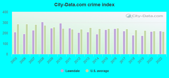
Crime rate in Lawndale detailed stats: murders, rapes, robberies, assaults, burglaries, thefts, arson
Full-time law enforcement employees in 2015, including police officers: 1 (1 officers - 1 male; 0 female).
| Officers per 1,000 residents here: | 0.03 |
| California average: | 1.98 |
 Recent articles from our blog. Our writers, many of them Ph.D. graduates or candidates, create easy-to-read articles on a wide variety of topics.

 | Is there anywhere in OC within a 'commutable' distance to LA? (52 replies) |
| Why so few non-Mesoamerican Hispanics in California? (24 replies) |
| California's immigrant communities/enclaves (20 replies) |
| Living in North Torrance/South Lawndale (7 replies) |
| Californians making below $50,000 keep leaving (238 replies) |
| Where can I move as a peruvian in LA? (10 replies) |
Latest news from Lawndale, CA collected exclusively by city-data.com from local newspapers, TV, and radio stations
Ancestries: German (1.6%), Nigerian (1.4%), Egyptian (1.3%), American (1.2%), Italian (1.1%), European (1.1%).
Current Local Time: PST time zone
Elevation: 55 feet
Land area: 1.98 square miles.
Population density: 15,463 people per square mile (very high).
12,305 residents are foreign born (28.0% Latin America, 8.2% Asia).
| This city: | 39.9% |
| California: | 26.5% |
Median real estate property taxes paid for housing units with mortgages in 2022: $4,486 (0.6%)
Median real estate property taxes paid for housing units with no mortgage in 2022: $4,341 (0.6%)
Nearest city with pop. 50,000+: Hawthorne, CA  (2.1 miles , pop. 84,112).
Nearest city with pop. 200,000+: Long Beach, CA (12.6 miles , pop. 461,522).
Nearest city with pop. 1,000,000+: Los Angeles, CA (13.9 miles , pop. 3,694,820).
Nearest cities:
), Latitude: 33.89 N, Longitude: 118.35 W
Daytime population change due to commuting: -8,905 (-28.8%)
Workers who live and work in this city: 2,292 (14.2%)
Area code commonly used in this area: 310
Property values in Lawndale, CA

Lawndale, California accommodation & food services, waste management - Economy and Business Data
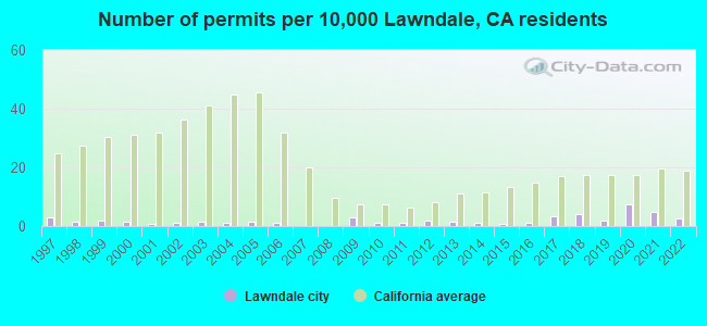
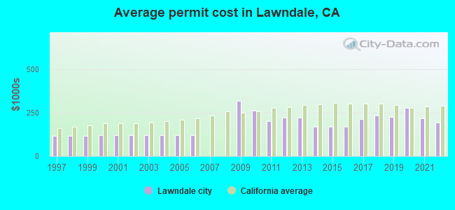
Single-family new house construction building permits:
- 2022: 8 buildings, average cost: $192,900
- 2021: 15 buildings, average cost: $220,300
- 2020: 23 buildings, average cost: $276,800
- 2019: 6 buildings, average cost: $224,800
- 2018: 13 buildings, average cost: $236,300
- 2017: 11 buildings, average cost: $216,200
- 2016: 3 buildings, average cost: $168,600
- 2015: 2 buildings, average cost: $168,600
- 2014: 4 buildings, average cost: $168,600
- 2013: 5 buildings, average cost: $221,300
- 2012: 6 buildings, average cost: $221,300
- 2011: 3 buildings, average cost: $201,600
- 2010: 3 buildings, average cost: $261,200
- 2009: 9 buildings, average cost: $318,400
- 2006: 3 buildings, average cost: $122,200
- 2005: 5 buildings, average cost: $122,200
- 2004: 4 buildings, average cost: $122,200
- 2003: 5 buildings, average cost: $122,200
- 2002: 4 buildings, average cost: $122,200
- 2001: 2 buildings, average cost: $122,200
- 2000: 5 buildings, average cost: $122,200
- 1999: 6 buildings, average cost: $115,600
- 1998: 5 buildings, average cost: $115,600
- 1997: 9 buildings, average cost: $115,600
| Here: | 4.1% |
| California: | 5.1% |
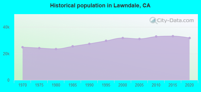
Population change in the 1990s: +4,327 (+15.8%).
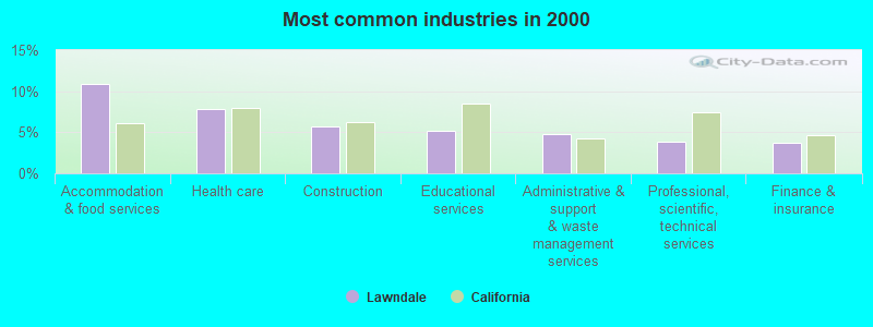
- Accommodation & food services (10.9%)
- Health care (7.8%)
- Construction (5.7%)
- Educational services (5.2%)
- Administrative & support & waste management services (4.7%)
- Professional, scientific, technical services (3.8%)
- Finance & insurance (3.7%)
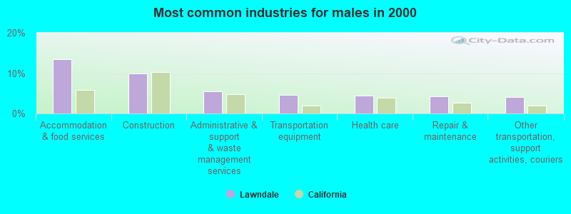
- Accommodation & food services (13.5%)
- Construction (10.0%)
- Administrative & support & waste management services (5.4%)
- Transportation equipment (4.6%)
- Health care (4.4%)
- Repair & maintenance (4.2%)
- Other transportation, support activities, couriers (4.1%)
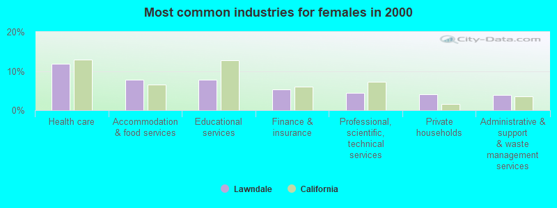
- Health care (11.9%)
- Accommodation & food services (7.8%)
- Educational services (7.8%)
- Finance & insurance (5.4%)
- Professional, scientific, technical services (4.4%)
- Private households (4.0%)
- Administrative & support & waste management services (3.9%)
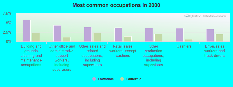
- Building and grounds cleaning and maintenance occupations (5.8%)
- Other office and administrative support workers, including supervisors (4.4%)
- Other sales and related occupations, including supervisors (3.9%)
- Retail sales workers, except cashiers (3.7%)
- Other production occupations, including supervisors (3.7%)
- Cashiers (3.5%)
- Driver/sales workers and truck drivers (3.3%)
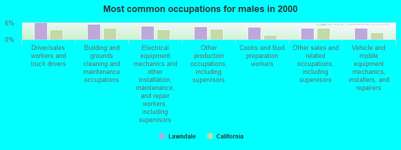
- Driver/sales workers and truck drivers (6.0%)
- Building and grounds cleaning and maintenance occupations (5.7%)
- Electrical equipment mechanics and other installation, maintenance, and repair workers, including supervisors (4.9%)
- Other production occupations, including supervisors (4.6%)
- Cooks and food preparation workers (4.6%)
- Other sales and related occupations, including supervisors (4.2%)
- Vehicle and mobile equipment mechanics, installers, and repairers (4.1%)
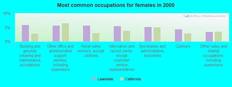
- Building and grounds cleaning and maintenance occupations (6.0%)
- Other office and administrative support workers, including supervisors (5.8%)
- Retail sales workers, except cashiers (5.7%)
- Information and record clerks, except customer service representatives (5.6%)
- Secretaries and administrative assistants (5.2%)
- Cashiers (4.5%)
- Other sales and related occupations, including supervisors (3.5%)
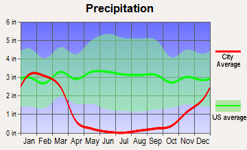
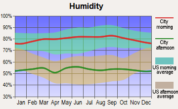
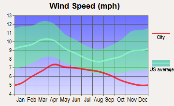
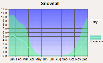
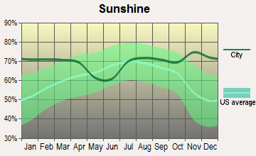
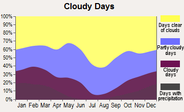
Average climate in Lawndale, California
Based on data reported by over 4,000 weather stations

|
|


(lower is better)
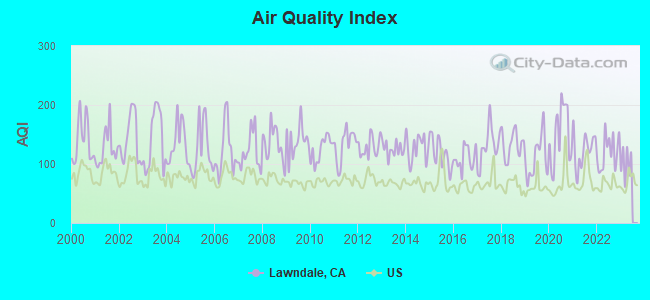
Air Quality Index (AQI) level in 2022 was 120. This is significantly worse than average.
| City: | 120 |
| U.S.: | 73 |
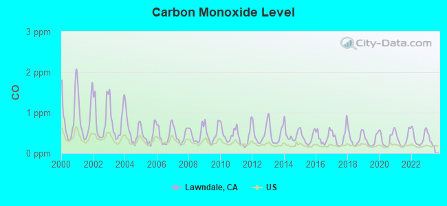
Carbon Monoxide (CO) [ppm] level in 2022 was 0.378. This is significantly worse than average. Closest monitor was 2.7 miles away from the city center.
| City: | 0.378 |
| U.S.: | 0.251 |
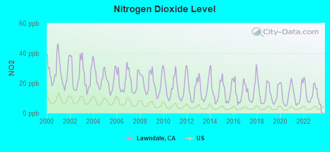
Nitrogen Dioxide (NO2) [ppb] level in 2022 was 13.7. This is significantly worse than average. Closest monitor was 2.7 miles away from the city center.
| City: | 13.7 |
| U.S.: | 5.1 |
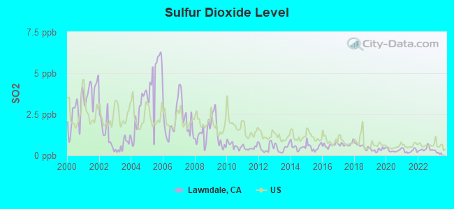
Sulfur Dioxide (SO2) [ppb] level in 2022 was 0.380. This is significantly better than average. Closest monitor was 2.7 miles away from the city center.
| City: | 0.380 |
| U.S.: | 1.515 |
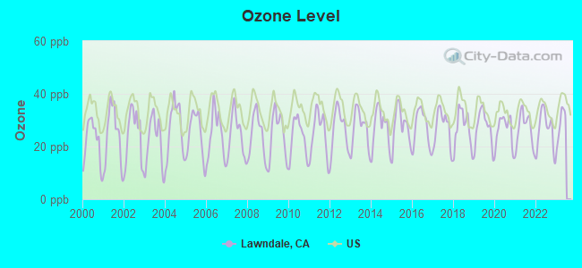
Ozone [ppb] level in 2022 was 26.3. This is better than average. Closest monitor was 2.7 miles away from the city center.
| City: | 26.3 |
| U.S.: | 33.3 |
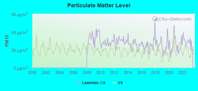
Particulate Matter (PM10) [µg/m3] level in 2022 was 30.4. This is significantly worse than average. Closest monitor was 2.7 miles away from the city center.
| City: | 30.4 |
| U.S.: | 19.2 |
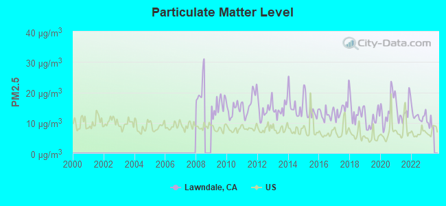
Particulate Matter (PM2.5) [µg/m3] level in 2022 was 12.3. This is significantly worse than average. Closest monitor was 8.6 miles away from the city center.
| City: | 12.3 |
| U.S.: | 8.1 |
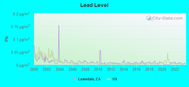
Lead (Pb) [µg/m3] level in 2022 was 0.00604. This is significantly better than average. Closest monitor was 2.7 miles away from the city center.
| City: | 0.00604 |
| U.S.: | 0.00931 |
Earthquake activity:
Lawndale-area historical earthquake activity is significantly above California state average. It is 6771% greater than the overall U.S. average.On 7/21/1952 at 11:52:14, a magnitude 7.7 (7.7 UK, Class: Major, Intensity: VIII - XII) earthquake occurred 85.4 miles away from the city center, causing $50,000,000 total damage
On 6/28/1992 at 11:57:34, a magnitude 7.6 (6.2 MB, 7.6 MS, 7.3 MW, Depth: 0.7 mi) earthquake occurred 106.4 miles away from Lawndale center, causing 3 deaths (1 shaking deaths, 2 other deaths) and 400 injuries, causing $100,000,000 total damage and $40,000,000 insured losses
On 10/16/1999 at 09:46:44, a magnitude 7.4 (6.3 MB, 7.4 MS, 7.2 MW, 7.3 ML) earthquake occurred 118.0 miles away from Lawndale center
On 11/4/1927 at 13:51:53, a magnitude 7.5 (7.5 UK) earthquake occurred 168.5 miles away from the city center
On 1/17/1994 at 12:30:55, a magnitude 6.8 (6.4 MB, 6.8 MS, 6.7 MW, Depth: 11.4 mi, Class: Strong, Intensity: VII - IX) earthquake occurred 22.5 miles away from the city center, causing 60 deaths (60 shaking deaths) and 7000 injuries
On 4/21/1918 at 22:32:30, a magnitude 6.8 (6.8 UK) earthquake occurred 52.7 miles away from the city center
Magnitude types: body-wave magnitude (MB), local magnitude (ML), surface-wave magnitude (MS), moment magnitude (MW)
Natural disasters:
The number of natural disasters in Los Angeles County (57) is a lot greater than the US average (15).Major Disasters (Presidential) Declared: 27
Emergencies Declared: 3
Causes of natural disasters: Fires: 37, Floods: 16, Storms: 9, Winter Storms: 6, Landslides: 5, Mudslides: 5, Earthquakes: 3, Freeze: 1, Heavy Rain: 1, Hurricane: 1, Snow: 1, Tornado: 1, Wind: 1, Other: 1 (Note: some incidents may be assigned to more than one category).
Hospitals and medical centers in Lawndale:
- BEACHSIDE HOME (4743 WEST 166TH STREET)
- MARY'S HOUSE (14901 CONDON AVE)
- ART HOME HEALTH CARE, INC (15342 HAWTHORNE AVE SUITE 400)
- PRODEX HOME HEALTH AGENCY (14719 HAWTHORNE BLVD #202)
- PROSPERITY HOME HEALTH SERVICES, INC (15901 HAWTHORNE BLVD SUITE 470)
- LAWNDALE HEALTHCARE AND WELLNESS CENTRE LLC (15100 S PRAIRIE)
Amtrak stations near Lawndale:
- 11 miles: SAN PEDRO (CATALINA TERMINAL, BERTH 95) - Bus Station . Services: partially wheelchair accessible, enclosed waiting area, public restrooms, public payphones, snack bar, paid short-term parking, paid long-term parking, call for taxi service.
- 13 miles: LONG BEACH (601 N. LONG BEACH BLVD.) - Bus Station . Services: fully wheelchair accessible, public restrooms, public payphones, full-service food facilities, paid short-term parking, paid long-term parking, call for taxi service, public transit connection.
- 14 miles: LOS ANGELES (800 N. ALAMEDA ST.) . Services: ticket office, fully wheelchair accessible, enclosed waiting area, public restrooms, public payphones, snack bar, free short-term parking, paid long-term parking, car rental agency, taxi stand, public transit connection.
Colleges/universities with over 2000 students nearest to Lawndale:
- El Camino Community College District (about 2 miles; Torrance, CA; Full-time enrollment: 13,952)
- Los Angeles Southwest College (about 5 miles; Los Angeles, CA; FT enrollment: 3,247)
- California State University-Dominguez Hills (about 6 miles; Carson, CA; FT enrollment: 9,862)
- Loyola Marymount University (about 7 miles; Los Angeles, CA; FT enrollment: 7,720)
- Los Angeles Harbor College (about 9 miles; Wilmington, CA; FT enrollment: 5,285)
- El Camino College-Compton Center (about 9 miles; Compton, CA; FT enrollment: 4,506)
- West Los Angeles College (about 9 miles; Culver City, CA; FT enrollment: 5,221)
Public high schools in Lawndale:
- LEUZINGER HIGH (Students: 1,808, Location: 4118 W. ROSECRANS AVE., Grades: 9-12)
- LAWNDALE HIGH (Students: 1,033, Location: 14901 S. INGLEWOOD AVE., Grades: 9-12)
- ENVIRONMENTAL CHARTER HIGH (Students: 345, Location: 16315 GREVILLEA AVE., Grades: 9-12, Charter school)
- R. K. LLOYDE HIGH (Students: 89, Location: 14901 INGLEWOOD AVE., Grades: 9-12)
- CENTINELA VALLEY INDEPENDENT STUDY (Students: 26, Location: 4409 REDONDO BEACH BLVD., Grades: 9-12)
- SOUTH BAY ACADEMY COMMUNITY DAY (Location: 4409 REDONDO BEACH BLVD., Grades: 9-12)
- FAMILY FIRST CHARTER (Location: 4953 MARINE AVE., Grades: 9-12, Charter school)
Public elementary/middle schools in Lawndale:
- WILL ROGERS MIDDLE (Students: 992, Location: 4110 W. 154TH ST., Grades: 6-8)
- JANE ADDAMS MIDDLE (Students: 857, Location: 4535 W. 153RD PL., Grades: 6-8)
- F. D. ROOSEVELT ELEMENTARY (Students: 502, Location: 3533 W. MARINE BLVD., Grades: KG-5)
- WILLIAM GREEN ELEMENTARY (Students: 457, Location: 4520 W. 168TH ST., Grades: KG-5)
- WILLIAM ANDERSON ELEMENTARY (Students: 452, Location: 4130 W. 154TH ST., Grades: KG-5)
- BILLY MITCHELL ELEMENTARY (Students: 374, Location: 14429 CONDON AVE., Grades: KG-5)
- LUCILLE J. SMITH ELEMENTARY (Students: 311, Location: 4521 W. 147TH ST., Grades: KG-5)
- MARK TWAIN ELEMENTARY (Students: 284, Location: 3728 W. 154TH ST., Grades: KG-5)
Points of interest:
Notable locations in Lawndale: Lawndale City Hall (A), Lawndale Branch County of Los Angeles Public Library (B), Lawndale Sheriff's Service Center (C), Los Angeles County Fire Department Station 21 (D). Display/hide their locations on the map
Churches in Lawndale include: Centinela Baptist Church (A), Foursquare Church of Lawndale (B), Iglesia La Resurrection (C), Kingdom Hall of Jehovahs Witnesses (D), Westside Korean Christian Church (E), The Wesleyan Church (F), Lawndale Church of Christ (G), First Congregational Church (H), First Baptist Church (I). Display/hide their locations on the map
Parks in Lawndale include: Jane Addams Park (1), Rogers-Anderson Park (2), William Green Park (3). Display/hide their locations on the map
Hotels: Best Western South Bay Hotel (15000 Hawthorne Boulevard), Budget Inn Motel (14815 Hawthorne Boulevard).
Birthplace of: Hal Mitchell - Football player.
Drinking water stations with addresses in Lawndale and their reported violations in the past:
THREE RIVERS GOLF COURSE (Population served: 100, Groundwater):Past monitoring violations:
- One regular monitoring violation
| This city: | 3.4 people |
| California: | 2.9 people |
| This city: | 74.0% |
| Whole state: | 68.7% |
| This city: | 8.1% |
| Whole state: | 7.2% |
Likely homosexual households (counted as self-reported same-sex unmarried-partner households)
- Lesbian couples: 0.4% of all households
- Gay men: 0.3% of all households
People in group quarters in Lawndale in 2010:
- 69 people in emergency and transitional shelters (with sleeping facilities) for people experiencing homelessness
- 46 people in group homes intended for adults
- 38 people in other noninstitutional facilities
- 6 people in correctional residential facilities
- 6 people in residential treatment centers for juveniles (non-correctional)
- 5 people in group homes for juveniles (non-correctional)
- 3 people in residential treatment centers for adults
- 2 people in workers' group living quarters and job corps centers
People in group quarters in Lawndale in 2000:
- 33 people in homes or halfway houses for drug/alcohol abuse
- 28 people in other noninstitutional group quarters
- 11 people in homes for the mentally retarded
- 10 people in other nonhousehold living situations
- 4 people in homes for the physically handicapped
For population 15 years and over in Lawndale:
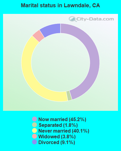
- Never married: 40.1%
- Now married: 45.2%
- Separated: 1.8%
- Widowed: 3.8%
- Divorced: 9.1%
For population 25 years and over in Lawndale:
- High school or higher: 72.4%
- Bachelor's degree or higher: 20.2%
- Graduate or professional degree: 5.3%
- Unemployed: 7.7%
- Mean travel time to work (commute): 22.5 minutes
| Here: | 19.3 |
| California average: | 15.5 |
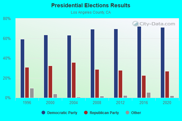
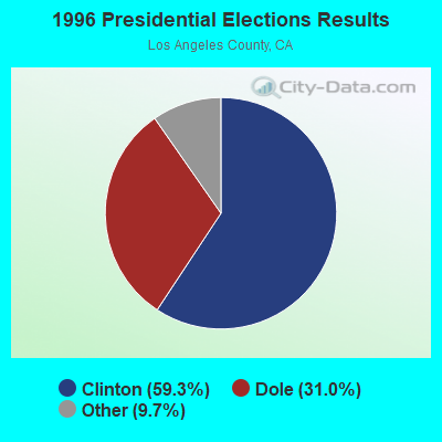
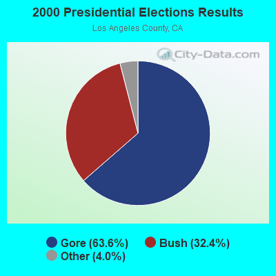
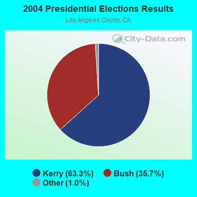
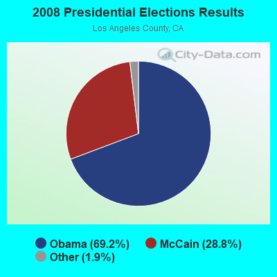

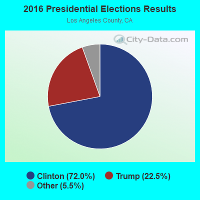
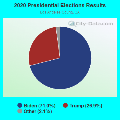
Graphs represent county-level data. Detailed 2008 Election Results
Neighborhoods in Lawndale:
(Lawndale, California Neighborhood Map)Religion statistics for Lawndale, CA (based on Los Angeles County data)
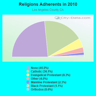
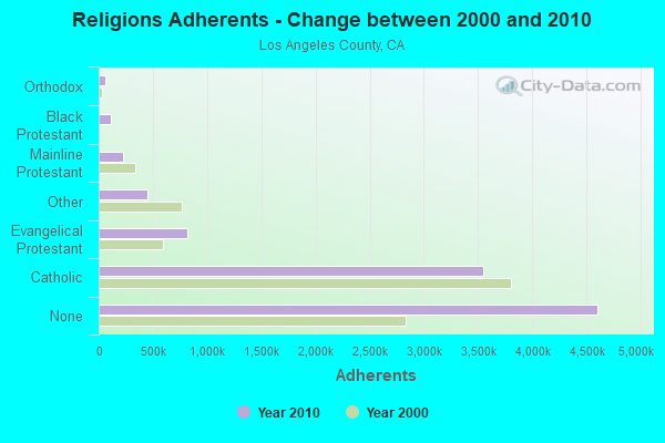
| Religion | Adherents | Congregations |
|---|---|---|
| Catholic | 3,542,994 | 275 |
| Evangelical Protestant | 814,611 | 3,249 |
| Other | 451,594 | 1,023 |
| Mainline Protestant | 229,056 | 860 |
| Black Protestant | 112,338 | 290 |
| Orthodox | 63,517 | 76 |
| None | 4,604,495 | - |
Food Environment Statistics:
| This county: | 2.12 / 10,000 pop. |
| California: | 2.14 / 10,000 pop. |
| This county: | 0.03 / 10,000 pop. |
| State: | 0.04 / 10,000 pop. |
| This county: | 0.58 / 10,000 pop. |
| State: | 0.62 / 10,000 pop. |
| This county: | 1.23 / 10,000 pop. |
| State: | 1.49 / 10,000 pop. |
| This county: | 7.15 / 10,000 pop. |
| California: | 7.42 / 10,000 pop. |
| Los Angeles County: | 7.5% |
| California: | 7.3% |
| Here: | 20.4% |
| California: | 21.3% |
| Here: | 18.6% |
| State: | 17.9% |
Health and Nutrition:
| Lawndale: | 47.3% |
| California: | 49.4% |
| Lawndale: | 47.2% |
| California: | 48.0% |
| Lawndale: | 28.3 |
| California: | 28.1 |
| Lawndale: | 21.1% |
| California: | 20.2% |
| This city: | 11.2% |
| California: | 11.2% |
| This city: | 6.7 |
| California: | 6.8 |
| Here: | 30.8% |
| State: | 31.5% |
| Here: | 55.8% |
| California: | 56.4% |
| Lawndale: | 82.6% |
| California: | 80.9% |
More about Health and Nutrition of Lawndale, CA Residents
| Local government employment and payroll (March 2022) | |||||
| Function | Full-time employees | Monthly full-time payroll | Average yearly full-time wage | Part-time employees | Monthly part-time payroll |
|---|---|---|---|---|---|
| Streets and Highways | 13 | $92,934 | $85,785 | 2 | $5,050 |
| Other Government Administration | 13 | $132,260 | $122,086 | 2 | $3,545 |
| Other and Unallocable | 4 | $29,583 | $88,749 | 1 | $3,290 |
| Financial Administration | 4 | $34,131 | $102,393 | 0 | $0 |
| Health | 3 | $18,066 | $72,264 | 0 | $0 |
| Welfare | 2 | $10,765 | $64,590 | 0 | $0 |
| Parks and Recreation | 1 | $13,326 | $159,912 | 6 | $6,626 |
| Totals for Government | 40 | $331,065 | $99,320 | 11 | $18,511 |
Lawndale government finances - Expenditure in 2017 (per resident):
- Construction - Housing and Community Development: $5,728,000 ($187.34)
Regular Highways: $1,097,000 ($35.88)
Parks and Recreation: $217,000 ($7.10)
- Current Operations - Police Protection: $5,481,000 ($179.26)
Central Staff Services: $4,070,000 ($133.11)
Parks and Recreation: $2,493,000 ($81.53)
Regular Highways: $1,785,000 ($58.38)
Protective Inspection and Regulation - Other: $1,051,000 ($34.37)
Financial Administration: $567,000 ($18.54)
Transit Utilities: $523,000 ($17.10)
Housing and Community Development: $141,000 ($4.61)
Health - Other: $72,000 ($2.35)
- General - Interest on Debt: $1,048,000 ($34.28)
- Intergovernmental to Local - Other - Police Protection: $5,481,000 ($179.26)
- Other Capital Outlay - Central Staff Services: $81,000 ($2.65)
Lawndale government finances - Revenue in 2017 (per resident):
- Charges - Other: $216,000 ($7.06)
Parks and Recreation: $198,000 ($6.48)
Housing and Community Development: $153,000 ($5.00)
- Federal Intergovernmental - Other: $639,000 ($20.90)
Housing and Community Development: $221,000 ($7.23)
- Local Intergovernmental - Other: $1,807,000 ($59.10)
- Miscellaneous - Fines and Forfeits: $764,000 ($24.99)
General Revenue - Other: $181,000 ($5.92)
Interest Earnings: $79,000 ($2.58)
Rents: $4,000 ($0.13)
- State Intergovernmental - Highways: $637,000 ($20.83)
Other: $196,000 ($6.41)
General Local Government Support: $4,000 ($0.13)
- Tax - Property: $4,574,000 ($149.59)
General Sales and Gross Receipts: $4,127,000 ($134.98)
Public Utilities Sales: $2,599,000 ($85.00)
Other Selective Sales: $661,000 ($21.62)
Other: $656,000 ($21.45)
Other License: $449,000 ($14.68)
Occupation and Business License - Other: $447,000 ($14.62)
Documentary and Stock Transfer: $59,000 ($1.93)
Lawndale government finances - Debt in 2017 (per resident):
- Long Term Debt - Beginning Outstanding - Unspecified Public Purpose: $19,926,000 ($651.69)
Outstanding Unspecified Public Purpose: $19,614,000 ($641.48)
Retired Unspecified Public Purpose: $311,000 ($10.17)
Lawndale government finances - Cash and Securities in 2017 (per resident):
- Other Funds - Cash and Securities: $13,638,000 ($446.04)
2.98% of this county's 2021 resident taxpayers lived in other counties in 2020 ($81,235 average adjusted gross income)
| Here: | 2.98% |
| California average: | 5.19% |
0.01% of residents moved from foreign countries ($155 average AGI)
Los Angeles County: 0.01% California average: 0.03%
Top counties from which taxpayers relocated into this county between 2020 and 2021:
| from Orange County, CA | |
| from San Bernardino County, CA | |
| from Riverside County, CA |
4.68% of this county's 2020 resident taxpayers moved to other counties in 2021 ($97,324 average adjusted gross income)
| Here: | 4.68% |
| California average: | 6.14% |
0.01% of residents moved to foreign countries ($196 average AGI)
Los Angeles County: 0.01% California average: 0.02%
Top counties to which taxpayers relocated from this county between 2020 and 2021:
| to Orange County, CA | |
| to San Bernardino County, CA | |
| to Riverside County, CA |
| Businesses in Lawndale, CA | ||||
| Name | Count | Name | Count | |
|---|---|---|---|---|
| 7-Eleven | 2 | Lane Furniture | 1 | |
| 99 Cents Only Stores | 1 | Little Caesars Pizza | 1 | |
| Best Western | 1 | McDonald's | 1 | |
| Blockbuster | 1 | Nike | 2 | |
| CVS | 2 | Panda Express | 1 | |
| Casual Male XL | 1 | RadioShack | 1 | |
| Domino's Pizza | 1 | Starbucks | 1 | |
| FedEx | 1 | T-Mobile | 1 | |
| H&R Block | 1 | Taco Bell | 1 | |
| Jack In The Box | 1 | UPS | 1 | |
| Jones New York | 2 | Wendy's | 1 | |
Strongest AM radio stations in Lawndale:
- KNX (1070 AM; 50 kW; LOS ANGELES, CA; Owner: INFINITY BROADCASTING OPERATIONS, INC.)
- KFWB (980 AM; 50 kW; LOS ANGELES, CA; Owner: INFINITY BROADCASTING OPERATIONS, INC.)
- KFI (640 AM; 50 kW; LOS ANGELES, CA; Owner: CAPSTAR TX LIMITED PARTNERSHIP)
- KSPN (710 AM; 50 kW; LOS ANGELES, CA; Owner: KABC-AM RADIO, INC.)
- KBLA (1580 AM; 50 kW; SANTA MONICA, CA)
- KMPC (1540 AM; 50 kW; LOS ANGELES, CA; Owner: ROSE CITY RADIO CORPORATION)
- KLAC (570 AM; 50 kW; LOS ANGELES, CA; Owner: AMFM RADIO LICENSES, L.L.C.)
- KTNQ (1020 AM; 50 kW; LOS ANGELES, CA; Owner: KTNQ-AM LICENSE CORP.)
- KXMX (1190 AM; 25 kW; ANAHEIM, CA; Owner: NEW INSPIRATION BROADCASTING COMPANY)
- KXTA (1150 AM; 50 kW; LOS ANGELES, CA; Owner: CITICASTERS LICENSES, L.P.)
- KFOX (1650 AM; 10 kW; TORRANCE, CA; Owner: CHAGAL COMMUNICATIONS, INC.)
- KDIS (1110 AM; 50 kW; PASADENA, CA; Owner: ABC,INC.)
- KRLA (870 AM; 20 kW; GLENDALE, CA; Owner: NEW INSPIRATION BROADCASTING COMPANY)
Strongest FM radio stations in Lawndale:
- KKBT (100.3 FM; LOS ANGELES, CA; Owner: RADIO ONE LICENSES, LLC)
- KZLA-FM (93.9 FM; LOS ANGELES, CA; Owner: EMMIS RADIO LICENSE CORPORATION)
- KPWR (105.9 FM; LOS ANGELES, CA; Owner: EMMIS RADIO LICENSE CORPORATION)
- KLSX (97.1 FM; LOS ANGELES, CA; Owner: INFINITY BROADCASTING OPERATIONS, INC.)
- KRTH-FM (101.1 FM; LOS ANGELES, CA; Owner: INFINITY BROADCASTING OPERATIONS, INC.)
- KUSC (91.5 FM; LOS ANGELES, CA; Owner: UNIVERSITY OF SOUTHERN CALIFORNIA)
- KKLA-FM (99.5 FM; LOS ANGELES, CA; Owner: NEW INSPIRATION BROADCASTING CO., INC.)
- KZAB (93.5 FM; REDONDO BEACH, CA; Owner: KZAB LICENSING, INC.)
- KCBS-FM (93.1 FM; LOS ANGELES, CA; Owner: INFINITY BROADCASTING OPERATIONS, INC.)
- KSCA (101.9 FM; GLENDALE, CA; Owner: HBC LICENSE CORPORATION)
- K212FA (90.3 FM; TEMPLE CITY, CA; Owner: EDUCATIONAL MEDIA FOUNDATION)
- KLOS (95.5 FM; LOS ANGELES, CA; Owner: KLOS-FM RADIO, INC.)
- KOST (103.5 FM; LOS ANGELES, CA; Owner: CAPSTAR TX LIMITED PARTNERSHIP)
- KLVE (107.5 FM; LOS ANGELES, CA; Owner: KLVE-FM LICENSE CORP.)
- KIIS-FM (102.7 FM; LOS ANGELES, CA; Owner: CITICASTERS LICENSES, L.P.)
- KPCC (89.3 FM; PASADENA, CA; Owner: PASADENA AREA COMMUNITY COLLEGE DISTRICT)
- KHHT (92.3 FM; LOS ANGELES, CA; Owner: AMFM RADIO LICENSES, L.L.C.)
- KBIG-FM (104.3 FM; LOS ANGELES, CA; Owner: AMFM RADIO LICENSES, L.L.C.)
- KMZT-FM (105.1 FM; LOS ANGELES, CA; Owner: MOUNT WILSON FM BROADCASTERS, INC.)
- KPFK (90.7 FM; LOS ANGELES, CA; Owner: PACIFICA FOUNDATION, INC)
TV broadcast stations around Lawndale:
- KTRO-LP (Channel 50; LANCASTER, CA; Owner: ROBERT D. ADELMAN)
- KCBS-TV (Channel 2; LOS ANGELES, CA; Owner: CBS BROADCASTING INC.)
- KTLA-TV (Channel 5; LOS ANGELES, CA; Owner: KTLA INC.)
- KABC-TV (Channel 7; LOS ANGELES, CA; Owner: ABC HOLDING COMPANY, INC.)
- KCAL-TV (Channel 9; LOS ANGELES, CA; Owner: VIACOM TELEVISION STATIONS GROUP OF LOS ANGELES LLC)
- KNBC (Channel 4; LOS ANGELES, CA; Owner: NBC SUBSIDIARY (KNBC-TV), INC.)
- National Bridge Inventory (NBI) Statistics
- 6Number of bridges
- 72ft / 22.0mTotal length
- 867,443Total average daily traffic
- 41,234Total average daily truck traffic
FCC Registered Broadcast Land Mobile Towers: 11 (See the full list of FCC Registered Broadcast Land Mobile Towers in Lawndale, CA)
FCC Registered Microwave Towers: 10 (See the full list of FCC Registered Microwave Towers in this town)
FCC Registered Amateur Radio Licenses: 125 (See the full list of FCC Registered Amateur Radio Licenses in Lawndale)
FAA Registered Aircraft: 11 (See the full list of FAA Registered Aircraft in Lawndale)
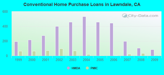
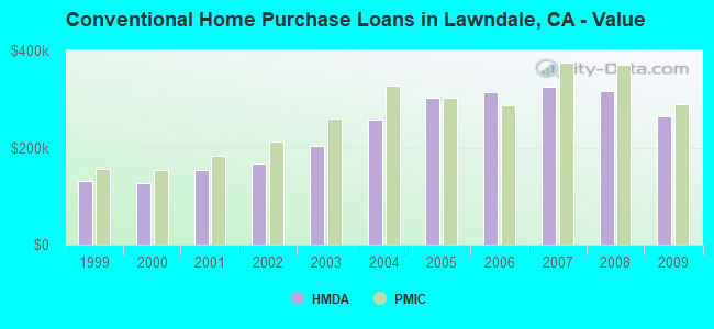
| Home Mortgage Disclosure Act Aggregated Statistics For Year 2009 (Based on 4 full tracts) | ||||||||||||||
| A) FHA, FSA/RHS & VA Home Purchase Loans | B) Conventional Home Purchase Loans | C) Refinancings | D) Home Improvement Loans | E) Loans on Dwellings For 5+ Families | F) Non-occupant Loans on < 5 Family Dwellings (A B C & D) | G) Loans On Manufactured Home Dwelling (A B C & D) | ||||||||
|---|---|---|---|---|---|---|---|---|---|---|---|---|---|---|
| Number | Average Value | Number | Average Value | Number | Average Value | Number | Average Value | Number | Average Value | Number | Average Value | Number | Average Value | |
| LOANS ORIGINATED | 54 | $304,000 | 84 | $264,250 | 213 | $251,779 | 10 | $250,900 | 3 | $1,782,333 | 53 | $261,698 | 1 | $342,000 |
| APPLICATIONS APPROVED, NOT ACCEPTED | 6 | $347,667 | 4 | $316,000 | 39 | $307,103 | 1 | $298,000 | 0 | $0 | 8 | $305,625 | 0 | $0 |
| APPLICATIONS DENIED | 15 | $325,267 | 34 | $269,618 | 146 | $320,760 | 8 | $203,500 | 0 | $0 | 19 | $279,053 | 0 | $0 |
| APPLICATIONS WITHDRAWN | 9 | $358,333 | 22 | $244,909 | 58 | $289,034 | 6 | $103,833 | 4 | $716,250 | 13 | $219,538 | 0 | $0 |
| FILES CLOSED FOR INCOMPLETENESS | 1 | $373,000 | 6 | $342,333 | 26 | $312,615 | 2 | $147,500 | 0 | $0 | 4 | $278,750 | 0 | $0 |
Detailed HMDA statistics for the following Tracts: 6038.00 , 6039.00, 6040.00, 6041.00
| Private Mortgage Insurance Companies Aggregated Statistics For Year 2009 (Based on 4 full tracts) | ||||
| A) Conventional Home Purchase Loans | B) Refinancings | |||
|---|---|---|---|---|
| Number | Average Value | Number | Average Value | |
| LOANS ORIGINATED | 6 | $288,667 | 1 | $266,000 |
| APPLICATIONS APPROVED, NOT ACCEPTED | 8 | $359,125 | 1 | $268,000 |
| APPLICATIONS DENIED | 2 | $211,000 | 1 | $304,000 |
| APPLICATIONS WITHDRAWN | 0 | $0 | 0 | $0 |
| FILES CLOSED FOR INCOMPLETENESS | 0 | $0 | 0 | $0 |
Detailed PMIC statistics for the following Tracts: 6038.00 , 6039.00, 6040.00, 6041.00
2005 - 2018 National Fire Incident Reporting System (NFIRS) incidents
- Fire incident types reported to NFIRS in Lawndale, CA
- 14835.1%Outside Fires
- 12930.6%Structure Fires
- 10825.6%Mobile Property/Vehicle Fires
- 378.8%Other
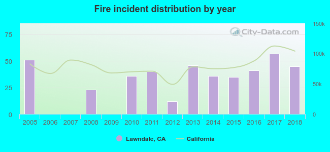 According to the data from the years 2005 - 2018 the average number of fires per year is 30. The highest number of reported fires - 57 took place in 2017, and the least - 0 in 2006. The data has a decreasing trend.
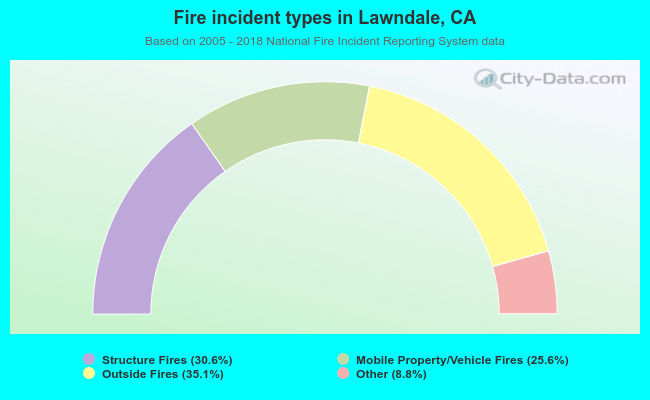 When looking into fire subcategories, the most reports belonged to: Outside Fires (35.1%), and Structure Fires (30.6%).
Fire-safe hotels and motels in Lawndale, California:
- Travelers Inn, 14808 Hawthorne Blvd, Lawndale, California 90260 , Phone: (310) 675-5228
- Baymont Inn & Suites Lax, 14814 Hawthorne Blvd, Lawndale, California 90260 , Phone: (310) 676-1111, Fax: (310) 676-0077
| Most common first names in Lawndale, CA among deceased individuals | ||
| Name | Count | Lived (average) |
|---|---|---|
| John | 114 | 71.5 years |
| William | 93 | 71.0 years |
| Mary | 84 | 75.7 years |
| James | 75 | 69.3 years |
| Robert | 70 | 66.6 years |
| George | 56 | 74.1 years |
| Charles | 55 | 69.7 years |
| Helen | 48 | 75.6 years |
| Edward | 47 | 71.9 years |
| Frank | 44 | 70.6 years |
| Most common last names in Lawndale, CA among deceased individuals | ||
| Last name | Count | Lived (average) |
|---|---|---|
| Johnson | 36 | 73.3 years |
| Smith | 32 | 69.9 years |
| Jones | 22 | 73.0 years |
| Brown | 21 | 77.7 years |
| Garcia | 19 | 66.8 years |
| Clark | 18 | 73.0 years |
| Nguyen | 18 | 73.4 years |
| Miller | 17 | 71.7 years |
| Martinez | 17 | 72.4 years |
| Lee | 15 | 76.2 years |
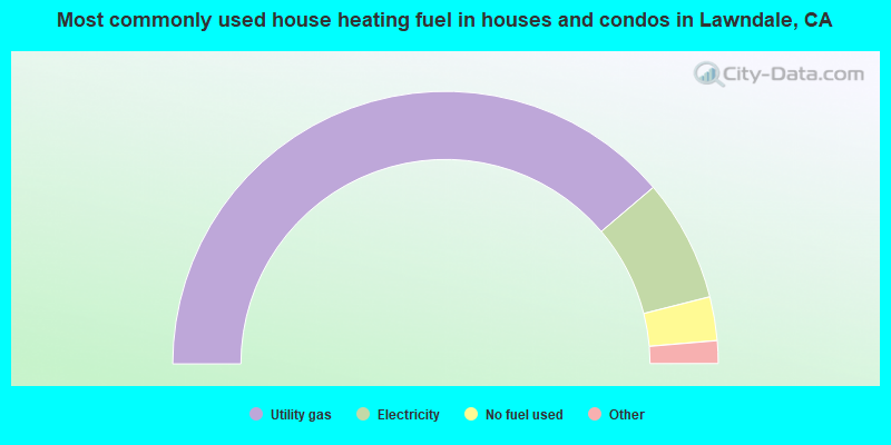
- 77.6%Utility gas
- 14.5%Electricity
- 5.2%No fuel used
- 2.2%Bottled, tank, or LP gas
- 0.2%Wood
- 0.2%Fuel oil, kerosene, etc.
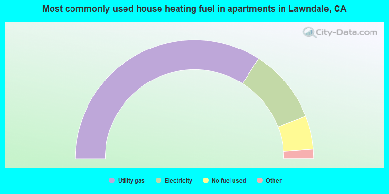
- 68.1%Utility gas
- 20.3%Electricity
- 9.1%No fuel used
- 1.5%Bottled, tank, or LP gas
- 0.5%Other fuel
- 0.5%Wood
Lawndale compared to California state average:
- Unemployed percentage below state average.
- Length of stay since moving in significantly above state average.
Lawndale on our top lists:
- #23 on the list of "Top 101 cities with the most residents born in Born at sea (population 500+)"
- #24 on the list of "Top 101 cities with largest percentage of males in occupations: food preparation and serving related occupations (population 5,000+)"
- #48 on the list of "Top 101 cities with largest percentage of males in industries: accommodation and food services (population 5,000+)"
- #77 on the list of "Top 100 cities with smallest houses (pop. 5,000+)"
- #82 on the list of "Top 101 cities with the highest housing density (population 2,000+)"
- #1 on the list of "Top 101 counties with the most Evangelical Protestant congregations"
- #1 on the list of "Top 101 counties with the most Mainline Protestant congregations"
- #1 on the list of "Top 101 counties with the most Orthodox adherents"
- #1 on the list of "Top 101 counties with the highest ground withdrawal of fresh water for public supply (pop. 50,000+)"
- #1 on the list of "Top 101 counties with the most Catholic adherents (pop. 50,000+)"

|
|
Total of 45 patent applications in 2008-2024.