Boxborough, Massachusetts
Submit your own pictures of this town and show them to the world
- OSM Map
- Google Map
- MSN Map
Population change since 2000: +2.6%
 |
| Males: 2,555 | |
| Females: 2,441 |
| Median resident age: | 43.3 years |
| Massachusetts median age: | 39.2 years |
Zip codes: 01719.
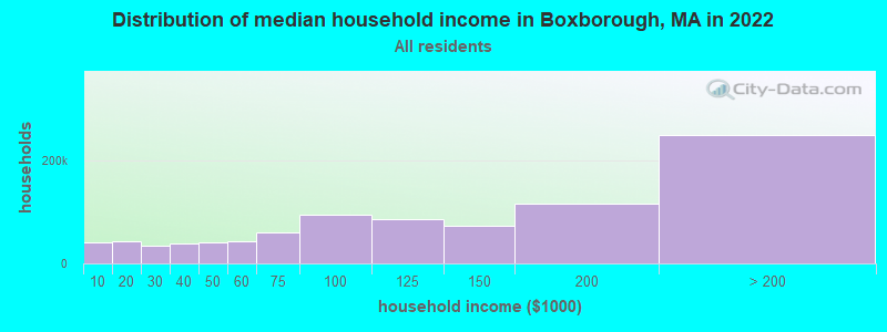
| Boxborough: | $171,142 |
| MA: | $94,488 |
Estimated per capita income in 2022: $84,696 (it was $40,794 in 2000)
Boxborough town income, earnings, and wages data
Estimated median house or condo value in 2022: $951,405 (it was $336,600 in 2000)
| Boxborough: | $951,405 |
| MA: | $534,700 |
Mean prices in 2022: all housing units: $796,617; detached houses: $834,667; townhouses or other attached units: $772,440; in 2-unit structures: $786,250; in 3-to-4-unit structures: $655,835; in 5-or-more-unit structures: $590,321; mobile homes: $144,935
Detailed information about poverty and poor residents in Boxborough, MA


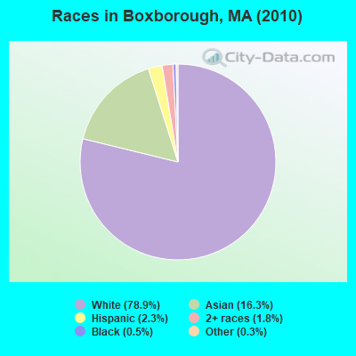
- 3,94078.9%White alone
- 81316.3%Asian alone
- 1132.3%Hispanic
- 901.8%Two or more races
- 240.5%Black alone
- 140.3%Other race alone
- 10.02%American Indian alone
- 10.02%Native Hawaiian and Other
Pacific Islander alone
Races in Boxborough detailed stats: ancestries, foreign born residents, place of birth
According to our research of Massachusetts and other state lists, there were 3 registered sex offenders living in Boxborough, Massachusetts as of April 26, 2024.
The ratio of all residents to sex offenders in Boxborough is 1,665 to 1.
The ratio of registered sex offenders to all residents in this city is near the state average.
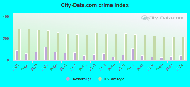
Type |
2009 |
2010 |
2011 |
2012 |
2013 |
2014 |
2015 |
2016 |
2017 |
2018 |
2019 |
2020 |
2021 |
2022 |
|---|---|---|---|---|---|---|---|---|---|---|---|---|---|---|
| Murders (per 100,000) | 0 (0.0) | 0 (0.0) | 0 (0.0) | 0 (0.0) | 0 (0.0) | 0 (0.0) | 0 (0.0) | 0 (0.0) | 0 (0.0) | 0 (0.0) | 0 (0.0) | 0 (0.0) | 0 (0.0) | 0 (0.0) |
| Rapes (per 100,000) | 0 (0.0) | 1 (20.0) | 0 (0.0) | 0 (0.0) | 0 (0.0) | 2 (38.6) | 0 (0.0) | 0 (0.0) | 3 (50.2) | 2 (30.1) | 0 (0.0) | 0 (0.0) | 1 (17.0) | 0 (0.0) |
| Robberies (per 100,000) | 0 (0.0) | 0 (0.0) | 1 (19.9) | 0 (0.0) | 1 (19.4) | 0 (0.0) | 1 (19.2) | 0 (0.0) | 0 (0.0) | 0 (0.0) | 0 (0.0) | 0 (0.0) | 0 (0.0) | 0 (0.0) |
| Assaults (per 100,000) | 6 (115.4) | 4 (80.1) | 5 (99.5) | 1 (19.6) | 7 (135.9) | 2 (38.6) | 2 (38.4) | 7 (134.0) | 15 (251.2) | 3 (45.2) | 4 (61.2) | 6 (102.5) | 3 (51.0) | 4 (74.4) |
| Burglaries (per 100,000) | 10 (192.3) | 13 (260.2) | 13 (258.7) | 4 (78.5) | 4 (77.7) | 6 (115.7) | 5 (95.9) | 3 (57.4) | 3 (50.2) | 1 (15.1) | 1 (15.3) | 1 (17.1) | 3 (51.0) | 8 (148.8) |
| Thefts (per 100,000) | 39 (750.0) | 25 (500.4) | 32 (636.7) | 44 (863.8) | 17 (330.0) | 20 (385.7) | 17 (326.0) | 16 (306.3) | 18 (301.4) | 14 (211.0) | 21 (321.1) | 6 (102.5) | 12 (204.1) | 19 (353.4) |
| Auto thefts (per 100,000) | 5 (96.2) | 0 (0.0) | 2 (39.8) | 0 (0.0) | 3 (58.2) | 1 (19.3) | 0 (0.0) | 3 (57.4) | 3 (50.2) | 1 (15.1) | 4 (61.2) | 0 (0.0) | 0 (0.0) | 3 (55.8) |
| Arson (per 100,000) | 2 (38.5) | 1 (20.0) | 0 (0.0) | 1 (19.6) | 0 (0.0) | 0 (0.0) | 0 (0.0) | 0 (0.0) | 0 (0.0) | 1 (15.1) | 0 (0.0) | 0 (0.0) | 0 (0.0) | 0 (0.0) |
| City-Data.com crime index | 74.2 | 70.3 | 72.6 | 44.0 | 56.3 | 63.6 | 33.2 | 47.7 | 110.0 | 43.9 | 31.0 | 25.8 | 35.5 | 43.9 |
The City-Data.com crime index weighs serious crimes and violent crimes more heavily. Higher means more crime, U.S. average is 246.1. It adjusts for the number of visitors and daily workers commuting into cities.
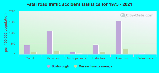
Crime rate in Boxborough detailed stats: murders, rapes, robberies, assaults, burglaries, thefts, arson
Full-time law enforcement employees in 2021, including police officers: 19 (13 officers - 12 male; 1 female).
| Officers per 1,000 residents here: | 2.21 |
| Massachusetts average: | 2.53 |
 Recent articles from our blog. Our writers, many of them Ph.D. graduates or candidates, create easy-to-read articles on a wide variety of topics.
Ancestries: Irish (20.1%), English (16.8%), German (13.4%), Italian (9.0%), United States (6.0%), Scottish (4.3%).
Current Local Time: EST time zone
Incorporated in 1835
Land area: 10.4 square miles.
Population density: 482 people per square mile (low).
614 residents are foreign born (7.0% Asia, 3.0% Europe).
| This town: | 12.6% |
| Massachusetts: | 12.2% |
| Boxborough town: | 1.4% ($4,867) |
| Massachusetts: | 1.3% ($2,336) |
Nearest city with pop. 50,000+: Framingham, MA  (13.6 miles , pop. 66,910).
Nearest city with pop. 200,000+: Boston, MA (24.4 miles , pop. 589,141).
Nearest city with pop. 1,000,000+: Bronx, NY (166.5 miles , pop. 1,332,650).
Nearest cities:
), ), Latitude: 42.49 N, Longitude: 71.51 W
Area code commonly used in this area: 978
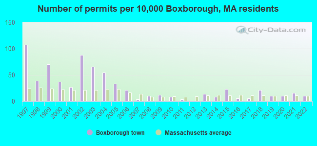
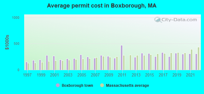
Single-family new house construction building permits:
- 2022: 5 buildings, average cost: $310,900
- 2021: 8 buildings, average cost: $310,900
- 2020: 5 buildings, average cost: $307,500
- 2019: 5 buildings, average cost: $320,900
- 2018: 10 buildings, average cost: $255,000
- 2017: 3 buildings, average cost: $335,000
- 2016: 3 buildings, average cost: $257,300
- 2015: 11 buildings, average cost: $315,500
- 2014: 4 buildings, average cost: $323,800
- 2013: 7 buildings, average cost: $243,500
- 2011: 2 buildings, average cost: $471,500
- 2010: 4 buildings, average cost: $229,100
- 2009: 6 buildings, average cost: $265,000
- 2008: 5 buildings, average cost: $282,000
- 2007: 2 buildings, average cost: $230,300
- 2006: 10 buildings, average cost: $251,500
- 2005: 16 buildings, average cost: $291,400
- 2004: 27 buildings, average cost: $220,600
- 2003: 32 buildings, average cost: $218,300
- 2002: 43 buildings, average cost: $196,300
- 2001: 13 buildings, average cost: $272,300
- 2000: 18 buildings, average cost: $283,800
- 1999: 34 buildings, average cost: $195,700
- 1998: 19 buildings, average cost: $183,300
- 1997: 52 buildings, average cost: $153,200
| Here: | 3.1% |
| Massachusetts: | 3.5% |
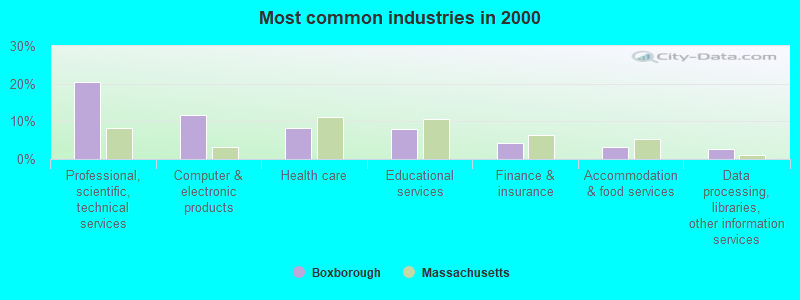
- Professional, scientific, technical services (20.5%)
- Computer & electronic products (11.6%)
- Health care (8.3%)
- Educational services (8.0%)
- Finance & insurance (4.2%)
- Accommodation & food services (3.2%)
- Data processing, libraries, other information services (2.7%)
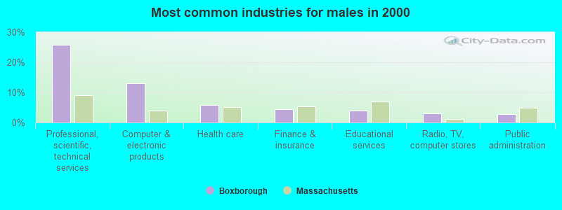
- Professional, scientific, technical services (25.8%)
- Computer & electronic products (12.9%)
- Health care (5.8%)
- Finance & insurance (4.4%)
- Educational services (3.9%)
- Radio, TV, computer stores (3.1%)
- Public administration (2.8%)
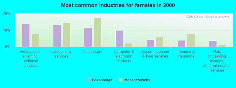
- Professional, scientific, technical services (13.7%)
- Educational services (13.2%)
- Health care (11.5%)
- Computer & electronic products (9.9%)
- Accommodation & food services (4.2%)
- Finance & insurance (3.9%)
- Data processing, libraries, other information services (3.8%)
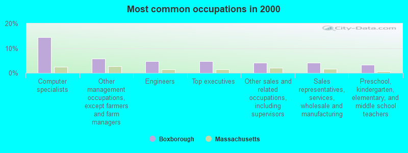
- Computer specialists (14.5%)
- Other management occupations, except farmers and farm managers (5.9%)
- Engineers (4.8%)
- Top executives (4.7%)
- Other sales and related occupations, including supervisors (4.2%)
- Sales representatives, services, wholesale and manufacturing (4.0%)
- Preschool, kindergarten, elementary, and middle school teachers (3.4%)

- Computer specialists (17.0%)
- Engineers (7.6%)
- Other management occupations, except farmers and farm managers (7.5%)
- Top executives (6.9%)
- Sales representatives, services, wholesale and manufacturing (5.2%)
- Other sales and related occupations, including supervisors (4.2%)
- Electrical equipment mechanics and other installation, maintenance, and repair workers, including supervisors (2.9%)

- Computer specialists (11.3%)
- Preschool, kindergarten, elementary, and middle school teachers (7.7%)
- Other office and administrative support workers, including supervisors (4.7%)
- Secretaries and administrative assistants (4.4%)
- Other sales and related occupations, including supervisors (4.2%)
- Other management occupations, except farmers and farm managers (3.7%)
- Retail sales workers, except cashiers (3.1%)
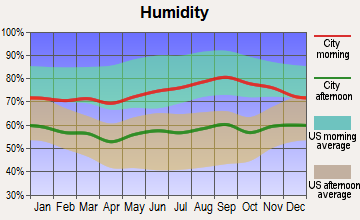
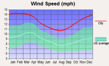
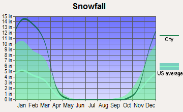
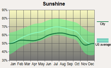
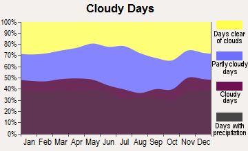
Average climate in Boxborough, Massachusetts
Based on data reported by over 4,000 weather stations


(lower is better)
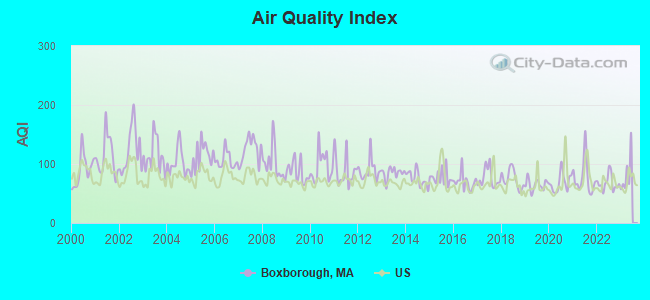
Air Quality Index (AQI) level in 2022 was 67.5. This is about average.
| City: | 67.5 |
| U.S.: | 72.6 |
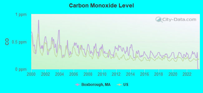
Carbon Monoxide (CO) [ppm] level in 2022 was 0.250. This is about average. Closest monitor was 15.1 miles away from the city center.
| City: | 0.250 |
| U.S.: | 0.251 |
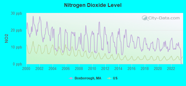
Nitrogen Dioxide (NO2) [ppb] level in 2022 was 10.9. This is significantly worse than average. Closest monitor was 5.2 miles away from the city center.
| City: | 10.9 |
| U.S.: | 5.1 |
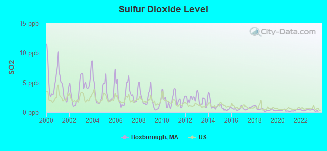
Sulfur Dioxide (SO2) [ppb] level in 2022 was 0.366. This is significantly better than average. Closest monitor was 5.2 miles away from the city center.
| City: | 0.366 |
| U.S.: | 1.515 |
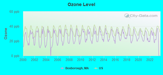
Ozone [ppb] level in 2022 was 26.4. This is better than average. Closest monitor was 12.4 miles away from the city center.
| City: | 26.4 |
| U.S.: | 33.3 |
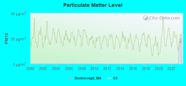

Particulate Matter (PM2.5) [µg/m3] level in 2022 was 6.86. This is about average. Closest monitor was 5.3 miles away from the city center.
| City: | 6.86 |
| U.S.: | 8.11 |
Tornado activity:
Boxborough-area historical tornado activity is slightly above Massachusetts state average. It is 27% smaller than the overall U.S. average.
On 6/9/1953, a category F4 (max. wind speeds 207-260 mph) tornado 12.9 miles away from the Boxborough town center killed 90 people and injured 1228 people and caused between $50,000,000 and $500,000,000 in damages.
On 10/3/1970, a category F3 (max. wind speeds 158-206 mph) tornado 5.8 miles away from the town center killed one person and caused between $50,000 and $500,000 in damages.
Earthquake activity:
Boxborough-area historical earthquake activity is significantly above Massachusetts state average. It is 72% smaller than the overall U.S. average.On 10/7/1983 at 10:18:46, a magnitude 5.3 (5.1 MB, 5.3 LG, 5.1 ML, Class: Moderate, Intensity: VI - VII) earthquake occurred 175.0 miles away from Boxborough center
On 4/20/2002 at 10:50:47, a magnitude 5.3 (5.3 ML, Depth: 3.0 mi) earthquake occurred 177.9 miles away from Boxborough center
On 1/19/1982 at 00:14:42, a magnitude 4.7 (4.5 MB, 4.7 MD, 4.5 LG, Class: Light, Intensity: IV - V) earthquake occurred 70.3 miles away from the city center
On 4/20/2002 at 10:50:47, a magnitude 5.2 (5.2 MB, 4.2 MS, 5.2 MW, 5.0 MW) earthquake occurred 177.2 miles away from Boxborough center
On 10/16/2012 at 23:12:25, a magnitude 4.7 (4.7 ML, Depth: 10.0 mi) earthquake occurred 88.2 miles away from the city center
On 8/22/1992 at 12:20:32, a magnitude 4.8 (4.8 MB, 3.8 MS, 4.7 LG, Depth: 6.2 mi) earthquake occurred 242.0 miles away from Boxborough center
Magnitude types: regional Lg-wave magnitude (LG), body-wave magnitude (MB), duration magnitude (MD), local magnitude (ML), surface-wave magnitude (MS), moment magnitude (MW)
Natural disasters:
The number of natural disasters in Middlesex County (31) is a lot greater than the US average (15).Major Disasters (Presidential) Declared: 17
Emergencies Declared: 14
Causes of natural disasters: Floods: 12, Storms: 9, Hurricanes: 6, Snowstorms: 6, Winter Storms: 5, Blizzards: 2, Snows: 2, Explosion: 1, Heavy Rain: 1, Snowfall: 1, Water Main Break: 1, Wind: 1 (Note: some incidents may be assigned to more than one category).
Main business address for: CYTYC CORP (LABORATORY ANALYTICAL INSTRUMENTS).
Hospitals and medical centers near Boxborough:
- LIFE CARE CENTER OF NASHOBA VALLEY (Nursing Home, about 3 miles away; LITTLETON, MA)
- LITTLETON HOUSE NH (Nursing Home, about 3 miles away; LITTLETON, MA)
- ACTON PUBLIC HEALTH NURSING SE (Home Health Center, about 5 miles away; ACTON, MA)
- SUBURBAN MANOR CONV AND NURSING HOME (Nursing Home, about 6 miles away; ACTON, MA)
- WOODFORD OF AYER NURSING HOME (Nursing Home, about 7 miles away; AYER, MA)
- WESTFORD HOUSE (Nursing Home, about 7 miles away; WESTFORD, MA)
- HUDSON NURSING HOME - OLD (Nursing Home, about 7 miles away; HUDSON, MA)
Heliports located in Boxborough:
See details about Heliports located in Boxborough, MAColleges/universities with over 2000 students nearest to Boxborough:
- Middlesex Community College (about 13 miles; Bedford, MA; Full-time enrollment: 6,040)
- Framingham State University (about 14 miles; Framingham, MA; FT enrollment: 5,743)
- University of Massachusetts-Lowell (about 16 miles; Lowell, MA; FT enrollment: 12,341)
- Brandeis University (about 16 miles; Waltham, MA; FT enrollment: 6,966)
- Fitchburg State University (about 16 miles; Fitchburg, MA; FT enrollment: 5,010)
- Bentley University (about 17 miles; Waltham, MA; FT enrollment: 5,229)
- Wellesley College (about 17 miles; Wellesley, MA; FT enrollment: 2,658)
Public elementary/middle school in Boxborough:
- BLANCHARD MEMORIAL SCHOOL (Students: 543, Location: 493 MASSACHUSETTS AVENUE, Grades: PK-6)
Points of interest:
Notable locations in Boxborough: Boxborough Fire Department (A), Blanchard Memorial School Library (B). Display/hide their locations on the map
Main business address in Boxborough: CYTYC CORP (A). Display/hide its location on the map
Church in Boxborough: United Church of Christ (A). Display/hide its location on the map
Cemeteries: New South Cemetery (1), Old South Cemetery (2), Old North Cemetery (3). Display/hide their locations on the map
Lakes, reservoirs, and swamps: Muddy Pond (A), Eldridge Pond (B), Flagg Hill Pond (C), Wolf Swamp (D). Display/hide their locations on the map
Streams, rivers, and creeks: Halfmoon Meadow Brook (A). Display/hide its location on the map
Tourist attraction: Nashoba Valley Olympia (Amusement & Theme Parks; 34 Massachusetts Avenue).
Hotel: Holiday Inn Boxborough (1 Adams Place).
Birthplace of: Bob Sweeney (ice hockey) - Ice hockey player.
Drinking water stations with addresses in Boxborough and their reported violations in the past:
APPLEWOOD CONDOMINIUM CORPORATION (Population served: 500, Groundwater):Past monitoring violations:BROOK VILLAGE CONDOMINIUM (Population served: 400, Groundwater):
- Follow-up Or Routine LCR Tap M/R - In JAN-01-2006, Contaminant: Lead and Copper Rule. Follow-up actions: St AO (w/o penalty) issued (DEC-12-2006), St Compliance achieved (FEB-05-2007)
Past health violations:Past monitoring violations:
- MCL, Monthly (TCR) - In MAY-2011, Contaminant: Coliform. Follow-up actions: St Compliance achieved (JUL-22-2011), St AO (w/o penalty) issued (JUL-22-2011), St Compliance achieved (JUN-11-2012)
- One minor monitoring violation
- 24 regular monitoring violations
| This town: | 2.6 people |
| Massachusetts: | 2.5 people |
| This town: | 69.9% |
| Whole state: | 63.0% |
| This town: | 4.4% |
| Whole state: | 7.0% |
Likely homosexual households (counted as self-reported same-sex unmarried-partner households)
- Lesbian couples: 0.6% of all households
- Gay men: 0.3% of all households
| This town: | 2.8% |
| Whole state: | 9.3% |
| This town: | 2.1% |
| Whole state: | 4.4% |
Banks with branches in Boxborough (2011 data):
- Middlesex Savings Bank: Boxborough Branch at 629 Massachusetts Avenue, branch established on 2006/01/31. Info updated 2009/07/16: Bank assets: $4,034.8 mil, Deposits: $3,490.0 mil, headquarters in Natick, MA, positive income, Mortgage Lending Specialization, 33 total offices, Holding Company: Middlesex Bancorp Mhc
For population 15 years and over in Boxborough:
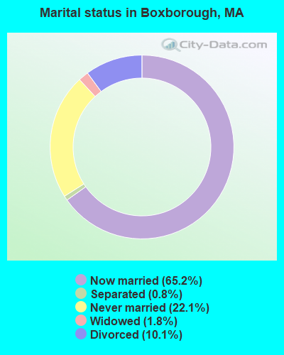
- Never married: 22.1%
- Now married: 65.2%
- Separated: 0.8%
- Widowed: 1.8%
- Divorced: 10.1%
For population 25 years and over in Boxborough:
- High school or higher: 98.0%
- Bachelor's degree or higher: 72.1%
- Graduate or professional degree: 32.4%
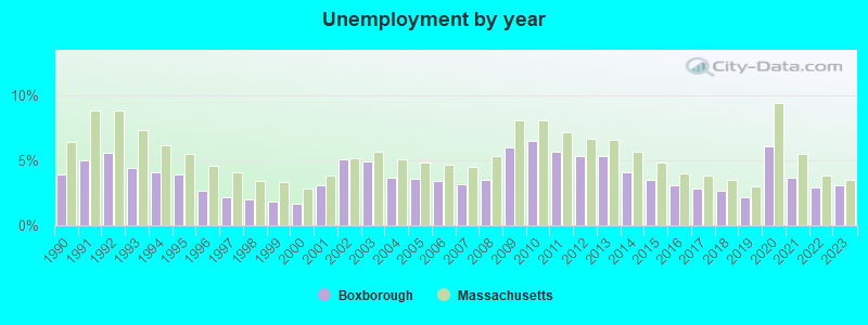
- Unemployed: 3.0%
- Mean travel time to work (commute): 31.7 minutes

| Here: | 8.1 |
| Massachusetts average: | 13.1 |


Graphs represent county-level data. Detailed 2008 Election Results
Religion statistics for Boxborough, MA (based on Middlesex County data)


| Religion | Adherents | Congregations |
|---|---|---|
| Catholic | 718,209 | 107 |
| Mainline Protestant | 70,053 | 269 |
| Other | 68,480 | 199 |
| Evangelical Protestant | 41,270 | 304 |
| Orthodox | 23,641 | 28 |
| Black Protestant | 2,276 | 8 |
| None | 579,156 | - |
Food Environment Statistics:
| This county: | 1.71 / 10,000 pop. |
| State: | 1.98 / 10,000 pop. |
| Middlesex County: | 0.03 / 10,000 pop. |
| State: | 0.05 / 10,000 pop. |
| Here: | 2.14 / 10,000 pop. |
| State: | 2.22 / 10,000 pop. |
| This county: | 1.38 / 10,000 pop. |
| Massachusetts: | 1.77 / 10,000 pop. |
| This county: | 7.84 / 10,000 pop. |
| Massachusetts: | 8.76 / 10,000 pop. |
| Middlesex County: | 7.8% |
| Massachusetts: | 8.1% |
| This county: | 21.5% |
| Massachusetts: | 22.5% |
| This county: | 18.0% |
| State: | 16.5% |
6.91% of this county's 2021 resident taxpayers lived in other counties in 2020 ($102,955 average adjusted gross income)
| Here: | 6.91% |
| Massachusetts average: | 6.35% |
0.01% of residents moved from foreign countries ($137 average AGI)
Middlesex County: 0.01% Massachusetts average: 0.01%
Top counties from which taxpayers relocated into this county between 2020 and 2021:
| from Suffolk County, MA | |
| from Essex County, MA | |
| from Norfolk County, MA |
8.22% of this county's 2020 resident taxpayers moved to other counties in 2021 ($123,369 average adjusted gross income)
| Here: | 8.22% |
| Massachusetts average: | 7.18% |
0.01% of residents moved to foreign countries ($124 average AGI)
Middlesex County: 0.01% Massachusetts average: 0.02%
Top counties to which taxpayers relocated from this county between 2020 and 2021:
| to Suffolk County, MA | |
| to Essex County, MA | |
| to Worcester County, MA |
| Businesses in Boxborough, MA | ||||
| Name | Count | Name | Count | |
|---|---|---|---|---|
| Dunkin Donuts | 1 | Holiday Inn | 1 | |
| FedEx | 3 | UPS | 1 | |
Strongest AM radio stations in Boxborough:
- WRKO (680 AM; 50 kW; BOSTON, MA; Owner: ENTERCOM BOSTON LICENSE, LLC)
- WKOX (1200 AM; 50 kW; FRAMINGHAM, MA; Owner: CAPSTAR TX LIMITED PARTNERSHIP)
- WBIX (1060 AM; 40 kW; NATICK, MA; Owner: LANGER BROADCASTING CORPORATION)
- WBNW (1120 AM; 5 kW; CONCORD, MA; Owner: MONEY MATTERS RADIO, INC.)
- WEEI (850 AM; 50 kW; BOSTON, MA; Owner: ENTERCOM BOSTON LICENSE, LLC)
- WWZN (1510 AM; 50 kW; BOSTON, MA; Owner: ROSE CITY RADIO CORPORATION)
- WAMG (890 AM; 25 kW; DEDHAM, MA; Owner: MEGA COMMUNICATIONS OF DEDHAM LICENSEE, LLC)
- WAZN (1470 AM; 7 kW; MARLBOROUGH, MA; Owner: MULTICULTURAL RADIO BROADCASTING, INC.)
- WCRN (830 AM; 50 kW; WORCESTER, MA; Owner: CARTER BROADCASTING CORPORATION)
- WRCA (1330 AM; 25 kW; WALTHAM, MA; Owner: WRCA LICENSE, LLC)
- WBZ (1030 AM; 50 kW; BOSTON, MA; Owner: INFINITY BROADCASTING OPERATIONS, INC.)
- WALE (990 AM; 50 kW; GREENVILLE, RI; Owner: NORTH AMERICAN BROADCASTING CO., INC.)
- WVNE (760 AM; daytime; 25 kW; LEICESTER, MA; Owner: BLOUNT MASSCOM, INC.)
Strongest FM radio stations in Boxborough:
- WBMX (98.5 FM; BOSTON, MA; Owner: INFINITY RADIO OPERATIONS INC.)
- WJMN (94.5 FM; BOSTON, MA; Owner: AMFM RADIO LICENSES, L.L.C.)
- WCRB (102.5 FM; WALTHAM, MA; Owner: CHARLES RIVER BROADCASTING WCRB LICE)
- WTKK (96.9 FM; BOSTON, MA; Owner: GREATER BOSTON RADIO, INC.)
- WROR-FM (105.7 FM; FRAMINGHAM, MA; Owner: GREATER BOSTON RADIO, INC.)
- WBOS (92.9 FM; BROOKLINE, MA; Owner: GREATER BOSTON RADIO, INC.)
- WGBH (89.7 FM; BOSTON, MA; Owner: WGBH EDUCATIONAL FOUNDATION)
- WBUR-FM (90.9 FM; BOSTON, MA; Owner: TRUSTEES OF BOSTON UNIVERSITY)
- WXKS-FM (107.9 FM; MEDFORD, MA; Owner: AMFM RADIO LICENSES, L.L.C.)
- WODS (103.3 FM; BOSTON, MA; Owner: INFINITY BROADCASTING OPERATIONS, INC.)
- WMJX (106.7 FM; BOSTON, MA; Owner: GREATER BOSTON RADIO, INC.)
- WXLO (104.5 FM; FITCHBURG, MA; Owner: CITADEL BROADCASTING COMPANY)
- WHAB (89.1 FM; ACTON, MA; Owner: ACTON-BOXBOROUGH REGIONAL SCH. DIST.)
- WAAF (107.3 FM; WORCESTER, MA; Owner: ENTERCOM BOSTON LICENSE, LLC)
- WFEX (92.1 FM; PETERBOROUGH, NH; Owner: FNX BROADCASTING OF NEW HAMPSHIRE LLC)
- WKLB-FM (99.5 FM; LOWELL, MA; Owner: GREATER BOSTON RADIO, INC.)
- WSRS (96.1 FM; WORCESTER, MA; Owner: CAPSTAR TX LIMITED PARTNERSHIP)
- WHOB (106.3 FM; NASHUA, NH; Owner: TELE-MEDIA COMPANY OF NEW HAMPSHIRE, L.L.C.)
- W227AM (93.3 FM; ANDOVER, MA; Owner: GREATER BOSTON RADIO, INC.)
- WBCN (104.1 FM; BOSTON, MA; Owner: HEMISPHERE BROADCASTING CORPORATION)
TV broadcast stations around Boxborough:
- WUTF (Channel 66; MARLBOROUGH, MA; Owner: TELEFUTURA BOSTON LLC)
- WUNI (Channel 27; WORCESTER, MA; Owner: ENTRAVISION HOLDINGS, LLC)
- WCVB-TV (Channel 5; BOSTON, MA; Owner: WCVB HEARST-ARGYLE TV, INC.)
- WGBH-TV (Channel 2; BOSTON, MA; Owner: WGBH EDUCATIONAL FOUNDATION)
- WHDH-TV (Channel 7; BOSTON, MA; Owner: WHDH-TV)
- WBZ-TV (Channel 4; BOSTON, MA; Owner: VIACOM INC.)
- WGBX-TV (Channel 44; BOSTON, MA; Owner: WGBH EDUCATIONAL FOUNDATION)
- WMFP (Channel 62; LAWRENCE, MA; Owner: WSAH LICENSE, INC.)
- WSBK-TV (Channel 38; BOSTON, MA; Owner: VIACOM INC.)
- WLVI-TV (Channel 56; CAMBRIDGE, MA; Owner: WLVI, INC.)
- WFXT (Channel 25; BOSTON, MA; Owner: FOX TELEVISION STATIONS INC.)
- W40BO (Channel 40; BOSTON, MA; Owner: PAXSON COMMUNICATIONS LPTV, INC.)
- WBPX (Channel 68; BOSTON, MA; Owner: PAXSON BOSTON-68 LICENSE, INC.)
- WFXZ-CA (Channel 24; BOSTON, MA; Owner: BOSTON BROADCASTING CORP.)
- WTMU-LP (Channel 32; BOSTON, MA; Owner: ZGS BOSTON, INC.)
- WCEA-LP (Channel 58; BOSTON, MA; Owner: CHANNEL 19 TV CORPORATION)
- WNDS (Channel 50; DERRY, NH; Owner: CTV OF DERRY, INC)
- WYDN (Channel 48; WORCESTER, MA; Owner: EDUCATIONAL PUBLIC TV CORPORATION)
- WWDP (Channel 46; NORWELL, MA; Owner: NORWELL TELEVISION, LLC)
- National Bridge Inventory (NBI) Statistics
- 4Number of bridges
- 39ft / 11.9mTotal length
- $13,343,000Total costs
- 165,096Total average daily traffic
- 4,336Total average daily truck traffic
FCC Registered Antenna Towers:
40 (See the full list of FCC Registered Antenna Towers in Boxborough)FCC Registered Broadcast Land Mobile Towers:
3- BLACKSTONE MA, 520 Mass Avenue (Lat: 42.481194 Lon: -71.507556), Structure height: 0 m, Call Sign: WPVP522,
Assigned Frequencies: 72.5200 MHz, Grant Date: 08/03/2022, Expiration Date: 07/25/2032, Certifier: William E Clayton, Registrant: Boxborough Fire Department, 4 Wheeling Ave, Woburn, MA 01801, Phone: (781) 933-0998, Fax: (781) 933-5019, Email:
- 80 Swanson Road (Lat: 42.488750 Lon: -71.545306), Type: Ltower, Structure height: 39.6 m, Call Sign: WQAC743,
Assigned Frequencies: 155.647 MHz, Grant Date: 03/07/2024, Expiration Date: 05/05/2034, Certifier: Warren Ryder, Registrant: Federal Licensing Inc, 1588 Fairfield Road, Gettysburg, PA 17325, Phone: (717) 334-9262, Fax: (717) 334-6440, Email:
- Lat: 42.482056 Lon: -71.506056, Call Sign: WQPN956,
Assigned Frequencies: 452.637 MHz, 457.637 MHz, 452.812 MHz, 457.812 MHz, Grant Date: 06/02/2022, Expiration Date: 07/10/2032, Certifier: Curtis Bates, Registrant: Cara Enterprises, Inc, 299 Brooks Street, Las Vegas, NV 89140-0124, Phone: (702) 838-9728, Fax: (702) 363-4607, Email:
FCC Registered Amateur Radio Licenses:
27 (See the full list of FCC Registered Amateur Radio Licenses in Boxborough)FAA Registered Aircraft:
4- Aircraft: SCHWEIZER SGS 1-26E (Category: Land, Weight: Up to 12,499 Pounds, Speed: 57 mph), Engine: None
N-Number: 1104S, N1104S, N-1104S, Serial Number: 504, Year manufactured: 1971, Airworthiness Date: 04/16/1971, Certificate Issue Date: 08/02/2013
Registrant (Individual): Dennis G Docherty, 96 Box Mill Rd, Boxborough, MA 01719 - Aircraft: GRUMMAN AMERICAN AVN. CORP. AA-5 (Category: Land, Seats: 4, Weight: Up to 12,499 Pounds, Speed: 105 mph), Engine: LYCOMING 0-320 SERIES (180 HP) (Reciprocating)
N-Number: 1335R, N1335R, N-1335R, Serial Number: AA5-0735, Year manufactured: 1975, Airworthiness Date: 01/30/1975, Certificate Issue Date: 12/01/1982
Registrant (Individual): Robert J Vanandel, 43 Waite, Boxborough, MA 01719 - Aircraft: PIPER PA-28-180 (Category: Land, Seats: 4, Weight: Up to 12,499 Pounds, Speed: 107 mph), Engine: LYCOMING O&VO-360 SER (180 HP) (Reciprocating)
N-Number: 16244, N16244, N-16244, Serial Number: 28-7305211, Year manufactured: 1973, Airworthiness Date: 01/10/1973, Certificate Issue Date: 08/04/2017
Registrant (Individual): William S Oakland, 66 Whitney Ln, Boxborough, MA 01719 - Aircraft: SCHERR ALLAN L LANCAIR IV (Category: Land, Seats: 4, Weight: Up to 12,499 Pounds), Engine: AMA/EXPR UNKNOWN ENG (Reciprocating)
N-Number: 4SX, N4SX, N-4SX, Serial Number: LIV-116, Year manufactured: 1999, Airworthiness Date: 09/20/1999, Certificate Issue Date: 12/19/2019
Registrant (Individual): Arthur Gallant, 221 Liberty Square Rd, Boxborough, MA 01719
2002 - 2018 National Fire Incident Reporting System (NFIRS) incidents
- Fire incident types reported to NFIRS in Boxborough, MA
- 14338.2%Outside Fires
- 9024.1%Structure Fires
- 8923.8%Mobile Property/Vehicle Fires
- 5213.9%Other
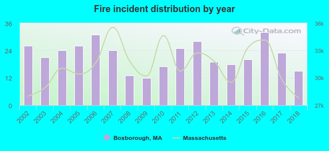 According to the data from the years 2002 - 2018 the average number of fire incidents per year is 22. The highest number of reported fire incidents - 32 took place in 2016, and the least - 12 in 2009. The data has a dropping trend.
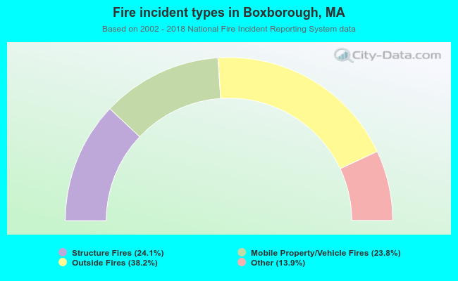 When looking into fire subcategories, the most reports belonged to: Outside Fires (38.2%), and Structure Fires (24.1%).
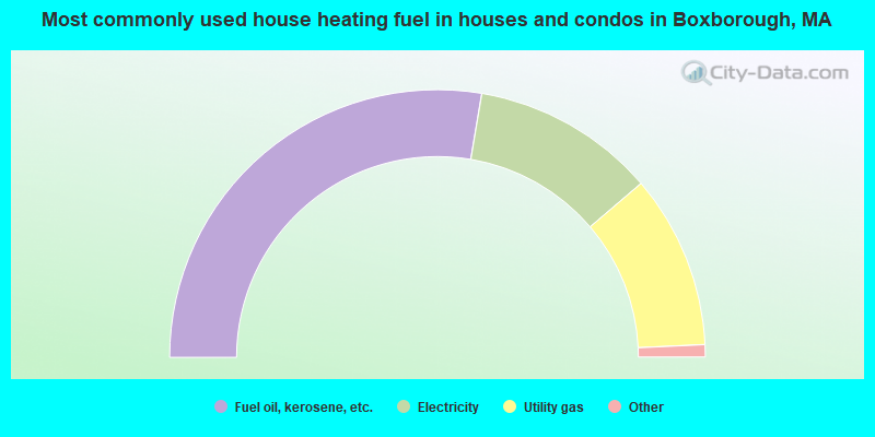
- 55.3%Fuel oil, kerosene, etc.
- 22.2%Electricity
- 21.0%Utility gas
- 0.5%Other fuel
- 0.5%Bottled, tank, or LP gas
- 0.5%Wood
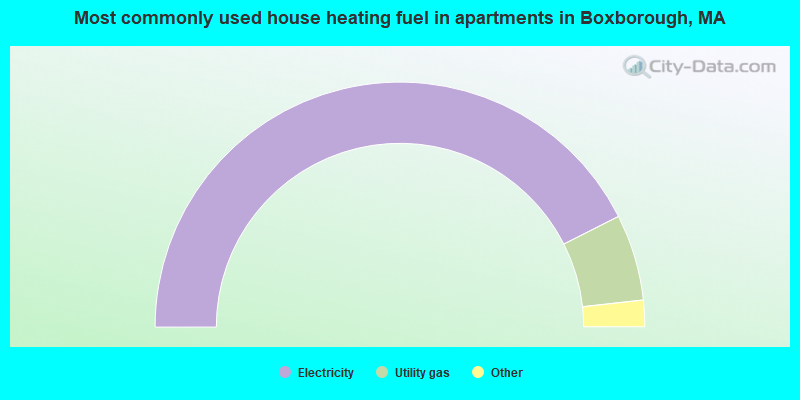
- 85.2%Electricity
- 11.4%Utility gas
- 2.4%Fuel oil, kerosene, etc.
- 1.1%Other fuel
Boxborough compared to Massachusetts state average:
- Median household income above state average.
- Median house value above state average.
- Unemployed percentage significantly below state average.
- Black race population percentage significantly below state average.
- Hispanic race population percentage significantly below state average.
- Median age above state average.
- Renting percentage below state average.
- Length of stay since moving in significantly above state average.
- Number of rooms per house significantly below state average.
- House age significantly below state average.
- Percentage of population with a bachelor's degree or higher above state average.

|
|
Total of 914 patent applications in 2008-2024.