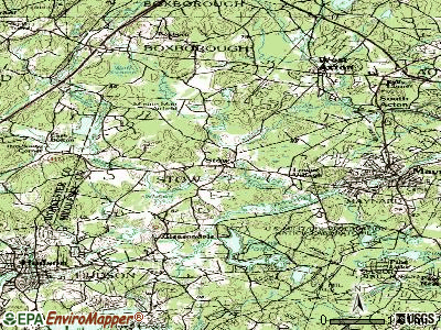
Stow, Massachusetts
Submit your own pictures of this town and show them to the world
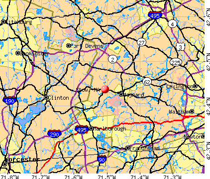
- OSM Map
- General Map
- Google Map
- MSN Map
Population change since 2000: +11.7%
 |
| Males: 3,244 | |
| Females: 3,346 |
| Median resident age: | 43.5 years |
| Massachusetts median age: | 39.2 years |
Zip codes: 01775.
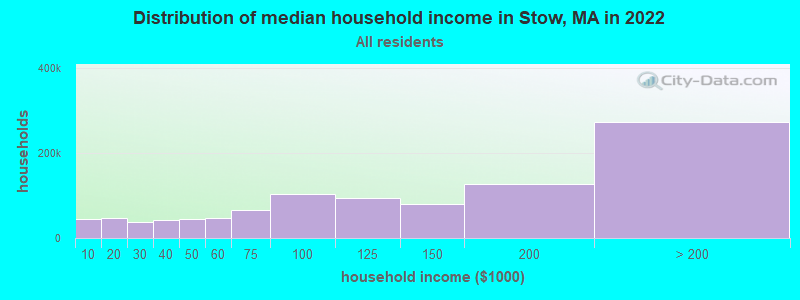
| Stow: | $188,081 |
| MA: | $94,488 |
Estimated per capita income in 2022: $79,435 (it was $38,260 in 2000)
Stow town income, earnings, and wages data
Estimated median house or condo value in 2022: $838,627 (it was $296,700 in 2000)
| Stow: | $838,627 |
| MA: | $534,700 |
Mean prices in 2022: all housing units: $796,617; detached houses: $834,667; townhouses or other attached units: $772,440; in 2-unit structures: $786,250; in 3-to-4-unit structures: $655,835; in 5-or-more-unit structures: $590,321; mobile homes: $144,935
Detailed information about poverty and poor residents in Stow, MA


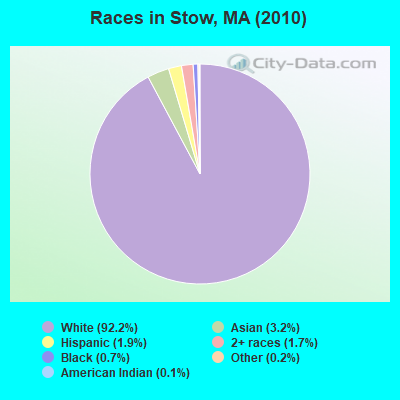
- 6,07992.2%White alone
- 2133.2%Asian alone
- 1221.9%Hispanic
- 1131.7%Two or more races
- 440.7%Black alone
- 100.2%Other race alone
- 90.1%American Indian alone
Races in Stow detailed stats: ancestries, foreign born residents, place of birth
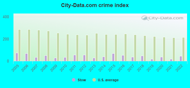
Type |
2009 |
2010 |
2011 |
2012 |
2013 |
2014 |
2015 |
2016 |
2017 |
2018 |
2019 |
2020 |
2021 |
2022 |
|---|---|---|---|---|---|---|---|---|---|---|---|---|---|---|
| Murders (per 100,000) | 0 (0.0) | 0 (0.0) | 0 (0.0) | 0 (0.0) | 0 (0.0) | 0 (0.0) | 0 (0.0) | 0 (0.0) | 0 (0.0) | 0 (0.0) | 0 (0.0) | 0 (0.0) | 0 (0.0) | 0 (0.0) |
| Rapes (per 100,000) | 1 (15.4) | 0 (0.0) | 1 (15.1) | 0 (0.0) | 0 (0.0) | 1 (14.3) | 2 (28.0) | 0 (0.0) | 0 (0.0) | 1 (13.9) | 0 (0.0) | 1 (13.8) | 0 (0.0) | 1 (14.3) |
| Robberies (per 100,000) | 0 (0.0) | 1 (15.2) | 2 (30.2) | 0 (0.0) | 1 (14.4) | 0 (0.0) | 0 (0.0) | 0 (0.0) | 0 (0.0) | 0 (0.0) | 0 (0.0) | 0 (0.0) | 1 (13.7) | 0 (0.0) |
| Assaults (per 100,000) | 1 (15.4) | 2 (30.3) | 1 (15.1) | 2 (29.8) | 3 (43.2) | 1 (14.3) | 7 (98.0) | 10 (138.9) | 5 (69.5) | 4 (55.8) | 4 (55.3) | 3 (41.3) | 2 (27.4) | 3 (42.9) |
| Burglaries (per 100,000) | 5 (77.2) | 10 (151.7) | 14 (211.2) | 26 (387.1) | 7 (100.7) | 8 (114.1) | 12 (168.0) | 14 (194.5) | 7 (97.3) | 12 (167.3) | 4 (55.3) | 0 (0.0) | 3 (41.1) | 7 (100.2) |
| Thefts (per 100,000) | 13 (200.8) | 23 (349.0) | 24 (362.0) | 33 (491.3) | 17 (244.6) | 28 (399.4) | 27 (378.1) | 20 (277.9) | 19 (264.0) | 19 (265.0) | 8 (110.6) | 22 (302.8) | 11 (150.8) | 27 (386.3) |
| Auto thefts (per 100,000) | 1 (15.4) | 0 (0.0) | 1 (15.1) | 4 (59.6) | 0 (0.0) | 1 (14.3) | 0 (0.0) | 0 (0.0) | 5 (69.5) | 4 (55.8) | 0 (0.0) | 5 (68.8) | 0 (0.0) | 1 (14.3) |
| Arson (per 100,000) | 0 (0.0) | 0 (0.0) | 0 (0.0) | 0 (0.0) | 0 (0.0) | 0 (0.0) | 0 (0.0) | 0 (0.0) | 0 (0.0) | 0 (0.0) | 1 (13.8) | 0 (0.0) | 0 (0.0) | 1 (14.3) |
| City-Data.com crime index | 30.1 | 35.2 | 54.6 | 57.5 | 29.8 | 39.4 | 68.9 | 52.5 | 36.8 | 49.1 | 19.4 | 36.9 | 18.5 | 43.6 |
The City-Data.com crime index weighs serious crimes and violent crimes more heavily. Higher means more crime, U.S. average is 246.1. It adjusts for the number of visitors and daily workers commuting into cities.
Crime rate in Stow detailed stats: murders, rapes, robberies, assaults, burglaries, thefts, arson
Full-time law enforcement employees in 2021, including police officers: 13 (11 officers - 10 male; 1 female).
| Officers per 1,000 residents here: | 1.51 |
| Massachusetts average: | 2.53 |
 Recent articles from our blog. Our writers, many of them Ph.D. graduates or candidates, create easy-to-read articles on a wide variety of topics.

 | 2024 Real Estate Observations (845 replies) |
| Searching for Progressive Town, Good Schools, Laid Back... Acton Shrewsbury Hopkinton Stow Ashland Northboro Westboro (37 replies) |
| Raising a family in Stow? (6 replies) |
| 2023 Real Estate Observations (5278 replies) |
| Big MA Ancestry Data Thread by Town (31 replies) |
| Harvard, Stow, Littleton, or Acton? (11 replies) |
Latest news from Stow, MA collected exclusively by city-data.com from local newspapers, TV, and radio stations
Ancestries: Irish (24.6%), English (20.1%), Italian (16.5%), French (8.8%), German (8.5%), Scottish (5.0%).
Current Local Time: EST time zone
Incorporated in 1683
Elevation: 231 feet
Land area: 17.6 square miles.
Population density: 374 people per square mile (very low).
451 residents are foreign born (4.5% Europe, 1.8% Asia, 0.9% Latin America).
| This town: | 7.6% |
| Massachusetts: | 12.2% |
| Stow town: | 1.4% ($4,185) |
| Massachusetts: | 1.3% ($2,336) |
Nearest city with pop. 50,000+: Framingham, MA  (9.6 miles , pop. 66,910).
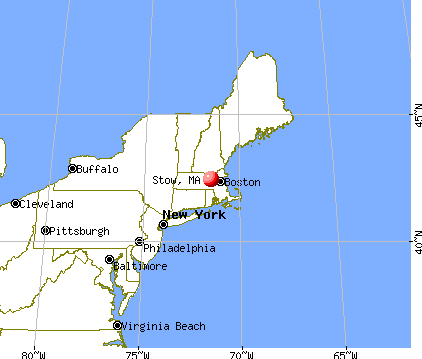
Nearest city with pop. 200,000+: Boston, MA (22.7 miles , pop. 589,141).
Nearest city with pop. 1,000,000+: Bronx, NY (163.7 miles , pop. 1,332,650).
Nearest cities:
), )Latitude: 42.42 N, Longitude: 71.51 W
Area code commonly used in this area: 978

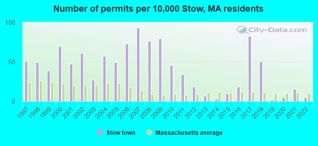
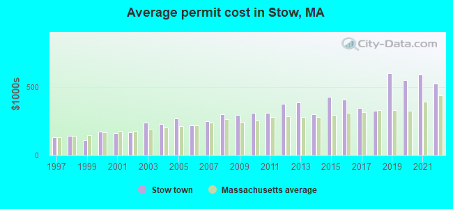
Single-family new house construction building permits:
- 2022: 3 buildings, average cost: $522,500
- 2021: 9 buildings, average cost: $590,500
- 2020: 3 buildings, average cost: $546,700
- 2019: 1 building, cost: $600,000
- 2018: 30 buildings, average cost: $326,400
- 2017: 49 buildings, average cost: $346,500
- 2016: 11 buildings, average cost: $409,100
- 2015: 6 buildings, average cost: $427,200
- 2014: 2 buildings, average cost: $300,000
- 2013: 4 buildings, average cost: $385,000
- 2012: 11 buildings, average cost: $377,200
- 2011: 20 buildings, average cost: $310,600
- 2010: 27 buildings, average cost: $308,900
- 2009: 47 buildings, average cost: $294,100
- 2008: 45 buildings, average cost: $302,400
- 2007: 55 buildings, average cost: $249,000
- 2006: 43 buildings, average cost: $216,900
- 2005: 29 buildings, average cost: $270,800
- 2004: 34 buildings, average cost: $228,100
- 2003: 16 buildings, average cost: $238,700
- 2002: 36 buildings, average cost: $167,500
- 2001: 28 buildings, average cost: $161,700
- 2000: 41 buildings, average cost: $173,000
- 1999: 23 buildings, average cost: $113,600
- 1998: 29 buildings, average cost: $141,900
- 1997: 30 buildings, average cost: $130,000
| Here: | 2.4% |
| Massachusetts: | 3.5% |
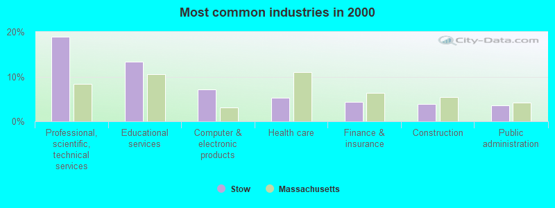
- Professional, scientific, technical services (18.8%)
- Educational services (13.3%)
- Computer & electronic products (7.1%)
- Health care (5.3%)
- Finance & insurance (4.4%)
- Construction (3.8%)
- Public administration (3.6%)
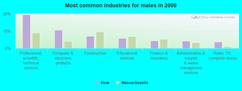
- Professional, scientific, technical services (19.7%)
- Computer & electronic products (10.7%)
- Construction (7.1%)
- Educational services (5.9%)
- Finance & insurance (4.3%)
- Administrative & support & waste management services (4.2%)
- Radio, TV, computer stores (3.6%)
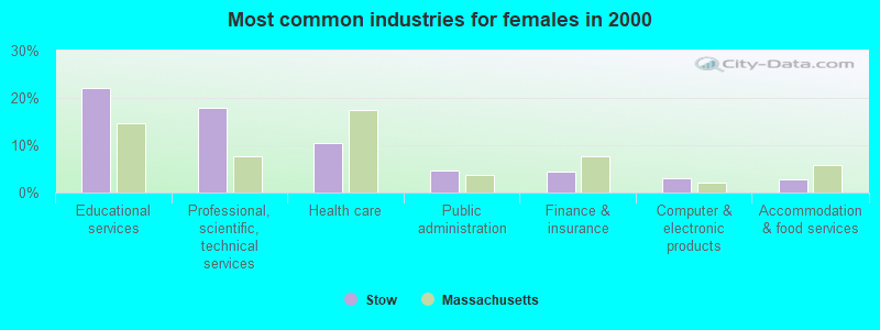
- Educational services (22.1%)
- Professional, scientific, technical services (17.8%)
- Health care (10.5%)
- Public administration (4.6%)
- Finance & insurance (4.4%)
- Computer & electronic products (2.9%)
- Accommodation & food services (2.8%)
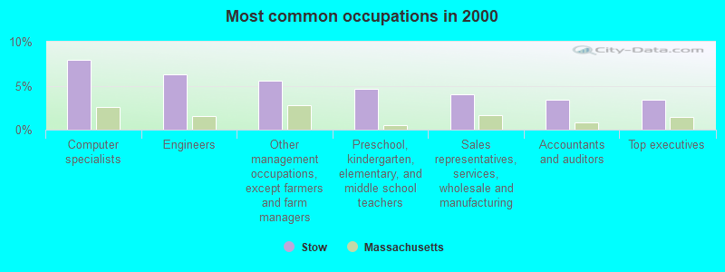
- Computer specialists (8.0%)
- Engineers (6.3%)
- Other management occupations, except farmers and farm managers (5.6%)
- Preschool, kindergarten, elementary, and middle school teachers (4.7%)
- Sales representatives, services, wholesale and manufacturing (4.1%)
- Accountants and auditors (3.4%)
- Top executives (3.4%)

- Computer specialists (11.5%)
- Engineers (11.0%)
- Other management occupations, except farmers and farm managers (7.0%)
- Sales representatives, services, wholesale and manufacturing (5.9%)
- Top executives (4.2%)
- Advertising, marketing, promotions, public relations, and sales managers (3.7%)
- Other sales and related occupations, including supervisors (3.1%)

- Preschool, kindergarten, elementary, and middle school teachers (8.2%)
- Information and record clerks, except customer service representatives (6.1%)
- Secretaries and administrative assistants (5.9%)
- Registered nurses (4.4%)
- Accountants and auditors (4.3%)
- Other management occupations, except farmers and farm managers (3.9%)
- Computer specialists (3.9%)
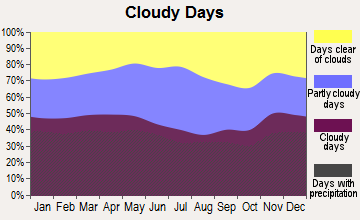
Average climate in Stow, Massachusetts
Based on data reported by over 4,000 weather stations
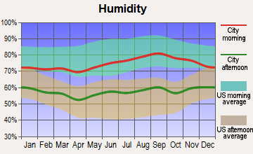
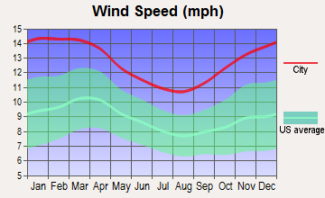
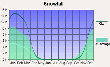
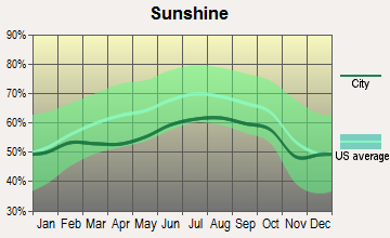
(lower is better)
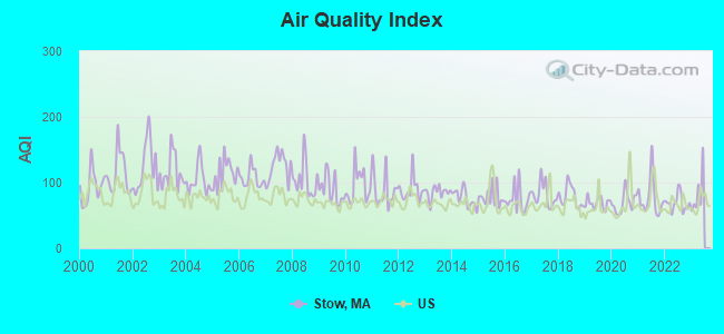
Air Quality Index (AQI) level in 2022 was 68.8. This is about average.
| City: | 68.8 |
| U.S.: | 72.6 |
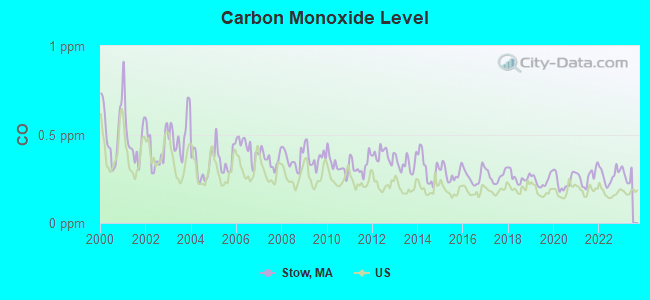
Carbon Monoxide (CO) [ppm] level in 2022 was 0.268. This is about average. Closest monitor was 14.5 miles away from the city center.
| City: | 0.268 |
| U.S.: | 0.251 |
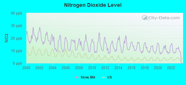
Nitrogen Dioxide (NO2) [ppb] level in 2022 was 10.8. This is significantly worse than average. Closest monitor was 1.9 miles away from the city center.
| City: | 10.8 |
| U.S.: | 5.1 |
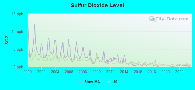
Sulfur Dioxide (SO2) [ppb] level in 2022 was 0.366. This is significantly better than average. Closest monitor was 1.9 miles away from the city center.
| City: | 0.366 |
| U.S.: | 1.515 |
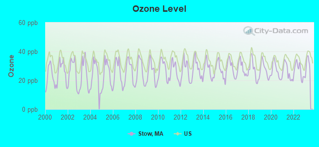
Ozone [ppb] level in 2022 was 26.9. This is better than average. Closest monitor was 10.0 miles away from the city center.
| City: | 26.9 |
| U.S.: | 33.3 |
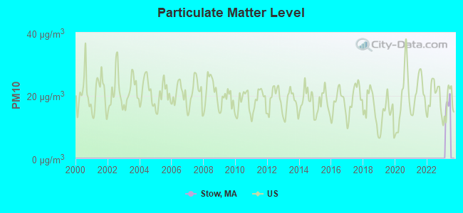
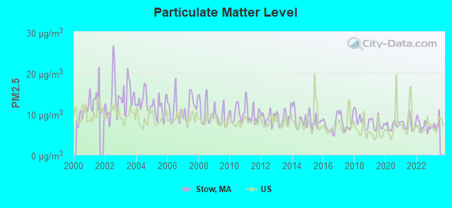
Particulate Matter (PM2.5) [µg/m3] level in 2022 was 7.09. This is about average. Closest monitor was 1.6 miles away from the city center.
| City: | 7.09 |
| U.S.: | 8.11 |
Tornado activity:
Stow-area historical tornado activity is slightly above Massachusetts state average. It is 28% smaller than the overall U.S. average.
On 6/9/1953, a category F4 (max. wind speeds 207-260 mph) tornado 8.6 miles away from the Stow town center killed 90 people and injured 1228 people and caused between $50,000,000 and $500,000,000 in damages.
On 10/3/1970, a category F3 (max. wind speeds 158-206 mph) tornado 10.1 miles away from the town center killed one person and caused between $50,000 and $500,000 in damages.
Earthquake activity:
Stow-area historical earthquake activity is significantly above Massachusetts state average. It is 72% smaller than the overall U.S. average.On 10/7/1983 at 10:18:46, a magnitude 5.3 (5.1 MB, 5.3 LG, 5.1 ML, Class: Moderate, Intensity: VI - VII) earthquake occurred 177.7 miles away from Stow center
On 4/20/2002 at 10:50:47, a magnitude 5.3 (5.3 ML, Depth: 3.0 mi) earthquake occurred 181.4 miles away from the city center
On 1/19/1982 at 00:14:42, a magnitude 4.7 (4.5 MB, 4.7 MD, 4.5 LG, Class: Light, Intensity: IV - V) earthquake occurred 74.6 miles away from the city center
On 4/20/2002 at 10:50:47, a magnitude 5.2 (5.2 MB, 4.2 MS, 5.2 MW, 5.0 MW) earthquake occurred 180.7 miles away from Stow center
On 10/16/2012 at 23:12:25, a magnitude 4.7 (4.7 ML, Depth: 10.0 mi) earthquake occurred 92.0 miles away from Stow center
On 8/22/1992 at 12:20:32, a magnitude 4.8 (4.8 MB, 3.8 MS, 4.7 LG, Depth: 6.2 mi) earthquake occurred 237.8 miles away from Stow center
Magnitude types: regional Lg-wave magnitude (LG), body-wave magnitude (MB), duration magnitude (MD), local magnitude (ML), surface-wave magnitude (MS), moment magnitude (MW)
Natural disasters:
The number of natural disasters in Middlesex County (31) is a lot greater than the US average (15).Major Disasters (Presidential) Declared: 17
Emergencies Declared: 14
Causes of natural disasters: Floods: 12, Storms: 9, Hurricanes: 6, Snowstorms: 6, Winter Storms: 5, Blizzards: 2, Snows: 2, Explosion: 1, Heavy Rain: 1, Snowfall: 1, Water Main Break: 1, Wind: 1 (Note: some incidents may be assigned to more than one category).
Hospitals and medical centers near Stow:
- HUDSON NURSING HOME - OLD (Nursing Home, about 4 miles away; HUDSON, MA)
- BRAEMOOR EAST OF MARLBORO (Nursing Home, about 5 miles away; MARLBOROUGH, MA)
- KINDRED TRANSITIONAL CARE AND REHAB-MARLBOROUGH (Nursing Home, about 5 miles away; MARLBOROUGH, MA)
- MARIE ESTHER HEALTH CENTER INC (Nursing Home, about 6 miles away; MARLBOROUGH, MA)
- MARLBOROUGH HOSPITAL Acute Care Hospitals (about 6 miles away; MARLBOROUGH, MA)
- SUDBURY PINES HOSPICE (Hospital, about 6 miles away; SUDBURY, MA)
- SUDBURY PINES EXTENDED CARE (Nursing Home, about 6 miles away; SUDBURY, MA)
Airports and heliports located in Stow:
- Minute Man Air Field Airport (6B6) (Runways: 2, Air Taxi Ops: 85, Itinerant Ops: 11,000, Local Ops: 10,000, Military Ops: 25)
- Crow Island Airport (8MA4) (Runways: 2)
- Compaq Stow Heliport (2MA8)
Amtrak stations near Stow:
- 12 miles: FRAMINGHAM (443 WAVERLY ST.) . Services: public payphones, snack bar, paid short-term parking, taxi stand, public transit connection.
- 19 miles: WORCESTER (WORCHESTER, 45 SHREWSBURY ST.) . Services: ticket office, fully wheelchair accessible, enclosed waiting area, public restrooms, public payphones, vending machines, free short-term parking, free long-term parking, call for taxi service, public transit connection.
- 20 miles: WOBURN (100 ATLANTIC AVE.) . Services: ticket office.
Colleges/universities with over 2000 students nearest to Stow:
- Framingham State University (about 10 miles; Framingham, MA; Full-time enrollment: 5,743)
- Brandeis University (about 14 miles; Waltham, MA; FT enrollment: 6,966)
- Wellesley College (about 14 miles; Wellesley, MA; FT enrollment: 2,658)
- Middlesex Community College (about 14 miles; Bedford, MA; FT enrollment: 6,040)
- Massachusetts Bay Community College (about 15 miles; Wellesley Hills, MA; FT enrollment: 3,636)
- Bentley University (about 16 miles; Waltham, MA; FT enrollment: 5,229)
- Babson College (about 16 miles; Wellesley, MA; FT enrollment: 3,230)
Public elementary/middle schools in Stow:
- HALE (Students: 257, Location: 55 HARTLEY ROAD, Grades: 6-8)
- CENTER SCHOOL (Location: 403 GREAT RD, Grades: PK-5)
Points of interest:
Notable locations in Stow: Carver Hill Orchards (A), Derby Orchard (B), Honey Pot Hill Orchards (C), One Stack Farm (D), Shelburne Farm (E), Butternut Farm Golf Course (F), Stowe Acres Country Club (G), Stow Away Golf Club (H), Stow Fire Department (I), Randall Library (J), Stowe Town Hall (K). Display/hide their locations on the map
Shopping Center: Stow Shopping Center (1). Display/hide its location on the map
Cemeteries: Hillside Cemetery (1), Brookside Cemetery (2), Hillside Cemetery (3). Display/hide their locations on the map
Lakes, reservoirs, and swamps: Ministers Pond (A), Flagg Hill Pond (B), Wheeler Pond (C), Lower Delaney Pond (D), Fletchers Pond (E), Lake Boon (F), Hiley Meadows (G). Display/hide their locations on the map
Streams, rivers, and creeks: Great Brook (A), Elizabeth Brook (B). Display/hide their locations on the map
Park in Stow: Marble Hill Conservation Area (1). Display/hide its location on the map
Hotel: Amerscot House (61 W Acton Rd).
Drinking water stations with addresses in Stow and their reported violations in the past:
JUNIPER HILL WATER COMPANY (Population served: 220, Groundwater):Past health violations:THE MEETING HOUSE @ STOW CONDO (Address: UNIT #100 , Population served: 92, Groundwater):Past monitoring violations:
- MCL, Monthly (TCR) - In AUG-2013, Contaminant: Coliform. Follow-up actions: St AO (w/o penalty) issued (OCT-09-2013)
- MCL, Monthly (TCR) - In JUL-2009, Contaminant: Coliform. Follow-up actions: St AO (w/o penalty) issued (SEP-22-2009), St Compliance achieved (SEP-22-2009)
- One minor monitoring violation
- 63 regular monitoring violations
Past monitoring violations:PLANTATION APARTMENTS (Population served: 54, Groundwater):
- Monitoring and Reporting (DBP) - Between JAN-2010 and MAR-2010, Contaminant: Chlorine. Follow-up actions: St Compliance achieved (MAR-09-2010), St AO (w/o penalty) issued (JUN-04-2010)
- Monitoring and Reporting (DBP) - Between JUL-2007 and SEP-2007, Contaminant: Chlorine. Follow-up actions: St Compliance achieved (OCT-10-2007), St AO (w/o penalty) issued (NOV-21-2007), St Compliance achieved (JAN-10-2008)
- Monitoring and Reporting (DBP) - Between APR-2007 and JUN-2007, Contaminant: Chlorine. Follow-up actions: St Compliance achieved (OCT-10-2007), St AO (w/o penalty) issued (NOV-21-2007), St Compliance achieved (JAN-10-2008)
- Monitoring and Reporting (DBP) - Between JAN-2007 and MAR-2007, Contaminant: Chlorine. Follow-up actions: St Compliance achieved (OCT-10-2007), St AO (w/o penalty) issued (NOV-21-2007), St Compliance achieved (JAN-10-2008)
- One minor monitoring violation
Past monitoring violations:
- 5 minor monitoring violations
- 3 regular monitoring violations
| This town: | 2.7 people |
| Massachusetts: | 2.5 people |
| This town: | 78.3% |
| Whole state: | 63.0% |
| This town: | 4.4% |
| Whole state: | 7.0% |
Likely homosexual households (counted as self-reported same-sex unmarried-partner households)
- Lesbian couples: 0.8% of all households
- Gay men: 0.3% of all households
| This town: | 2.7% |
| Whole state: | 9.3% |
| This town: | 1.9% |
| Whole state: | 4.4% |
26 people in nursing homes in 2000
2 people in agriculture workers' dormitories on farms in 2000
Banks with branches in Stow (2011 data):
- Family Federal Savings, F.A.: Great Road Branch at 149 Great Road, branch established on 1877/01/01. Info updated 2011/07/21: Bank assets: $99.6 mil, Deposits: $78.9 mil, headquarters in Fitchburg, MA, positive income, Mortgage Lending Specialization, 3 total offices
- RBS Citizens, National Association: Stow Branch at 159 Great Road, branch established on 1964/08/03. Info updated 2007/09/19: Bank assets: $106,940.6 mil, Deposits: $75,690.2 mil, headquarters in Providence, RI, positive income, 1135 total offices, Holding Company: Uk Financial Investments Limited
For population 15 years and over in Stow:
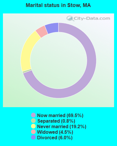
- Never married: 19.2%
- Now married: 69.5%
- Separated: 0.8%
- Widowed: 4.5%
- Divorced: 6.0%
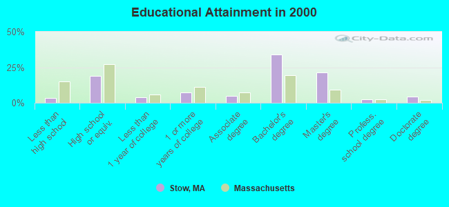
For population 25 years and over in Stow:
- High school or higher: 96.5%
- Bachelor's degree or higher: 61.9%
- Graduate or professional degree: 28.0%
- Unemployed: 2.5%
- Mean travel time to work (commute): 31.1 minutes
| Here: | 10.3 |
| Massachusetts average: | 13.1 |


Graphs represent county-level data. Detailed 2008 Election Results
Religion statistics for Stow, MA (based on Middlesex County data)


| Religion | Adherents | Congregations |
|---|---|---|
| Catholic | 718,209 | 107 |
| Mainline Protestant | 70,053 | 269 |
| Other | 68,480 | 199 |
| Evangelical Protestant | 41,270 | 304 |
| Orthodox | 23,641 | 28 |
| Black Protestant | 2,276 | 8 |
| None | 579,156 | - |
Food Environment Statistics:
| Middlesex County: | 1.71 / 10,000 pop. |
| Massachusetts: | 1.98 / 10,000 pop. |
| Middlesex County: | 0.03 / 10,000 pop. |
| Massachusetts: | 0.05 / 10,000 pop. |
| This county: | 2.14 / 10,000 pop. |
| Massachusetts: | 2.22 / 10,000 pop. |
| Middlesex County: | 1.38 / 10,000 pop. |
| Massachusetts: | 1.77 / 10,000 pop. |
| Here: | 7.84 / 10,000 pop. |
| Massachusetts: | 8.76 / 10,000 pop. |
| This county: | 7.8% |
| Massachusetts: | 8.1% |
| This county: | 21.5% |
| Massachusetts: | 22.5% |
| This county: | 18.0% |
| Massachusetts: | 16.5% |
6.91% of this county's 2021 resident taxpayers lived in other counties in 2020 ($102,955 average adjusted gross income)
| Here: | 6.91% |
| Massachusetts average: | 6.35% |
0.01% of residents moved from foreign countries ($137 average AGI)
Middlesex County: 0.01% Massachusetts average: 0.01%
Top counties from which taxpayers relocated into this county between 2020 and 2021:
| from Suffolk County, MA | |
| from Essex County, MA | |
| from Norfolk County, MA |
8.22% of this county's 2020 resident taxpayers moved to other counties in 2021 ($123,369 average adjusted gross income)
| Here: | 8.22% |
| Massachusetts average: | 7.18% |
0.01% of residents moved to foreign countries ($124 average AGI)
Middlesex County: 0.01% Massachusetts average: 0.02%
Top counties to which taxpayers relocated from this county between 2020 and 2021:
| to Suffolk County, MA | |
| to Essex County, MA | |
| to Worcester County, MA |
| Businesses in Stow, MA | ||||
| Name | Count | Name | Count | |
|---|---|---|---|---|
| Ace Hardware | 1 | FedEx | 2 | |
| Curves | 1 | H&R Block | 1 | |
| Dunkin Donuts | 2 | Shaw's | 1 | |
Strongest AM radio stations in Stow:
- WKOX (1200 AM; 50 kW; FRAMINGHAM, MA; Owner: CAPSTAR TX LIMITED PARTNERSHIP)
- WBIX (1060 AM; 40 kW; NATICK, MA; Owner: LANGER BROADCASTING CORPORATION)
- WRKO (680 AM; 50 kW; BOSTON, MA; Owner: ENTERCOM BOSTON LICENSE, LLC)
- WEEI (850 AM; 50 kW; BOSTON, MA; Owner: ENTERCOM BOSTON LICENSE, LLC)
- WAZN (1470 AM; 7 kW; MARLBOROUGH, MA; Owner: MULTICULTURAL RADIO BROADCASTING, INC.)
- WBNW (1120 AM; 5 kW; CONCORD, MA; Owner: MONEY MATTERS RADIO, INC.)
- WAMG (890 AM; 25 kW; DEDHAM, MA; Owner: MEGA COMMUNICATIONS OF DEDHAM LICENSEE, LLC)
- WWZN (1510 AM; 50 kW; BOSTON, MA; Owner: ROSE CITY RADIO CORPORATION)
- WRCA (1330 AM; 25 kW; WALTHAM, MA; Owner: WRCA LICENSE, LLC)
- WCRN (830 AM; 50 kW; WORCESTER, MA; Owner: CARTER BROADCASTING CORPORATION)
- WALE (990 AM; 50 kW; GREENVILLE, RI; Owner: NORTH AMERICAN BROADCASTING CO., INC.)
- WBZ (1030 AM; 50 kW; BOSTON, MA; Owner: INFINITY BROADCASTING OPERATIONS, INC.)
- WUNR (1600 AM; 20 kW; BROOKLINE, MA; Owner: CHAMPION BROADCASTING SYSTEMS, INC.)
Strongest FM radio stations in Stow:
- WBMX (98.5 FM; BOSTON, MA; Owner: INFINITY RADIO OPERATIONS INC.)
- WJMN (94.5 FM; BOSTON, MA; Owner: AMFM RADIO LICENSES, L.L.C.)
- WCRB (102.5 FM; WALTHAM, MA; Owner: CHARLES RIVER BROADCASTING WCRB LICE)
- WTKK (96.9 FM; BOSTON, MA; Owner: GREATER BOSTON RADIO, INC.)
- WROR-FM (105.7 FM; FRAMINGHAM, MA; Owner: GREATER BOSTON RADIO, INC.)
- WGBH (89.7 FM; BOSTON, MA; Owner: WGBH EDUCATIONAL FOUNDATION)
- WBOS (92.9 FM; BROOKLINE, MA; Owner: GREATER BOSTON RADIO, INC.)
- WBUR-FM (90.9 FM; BOSTON, MA; Owner: TRUSTEES OF BOSTON UNIVERSITY)
- WODS (103.3 FM; BOSTON, MA; Owner: INFINITY BROADCASTING OPERATIONS, INC.)
- WYAJ (97.7 FM; SUDBURY, MA; Owner: SUDBURY VALLEY B'CASTING FOUNDATION)
- WXKS-FM (107.9 FM; MEDFORD, MA; Owner: AMFM RADIO LICENSES, L.L.C.)
- WAAF (107.3 FM; WORCESTER, MA; Owner: ENTERCOM BOSTON LICENSE, LLC)
- WMJX (106.7 FM; BOSTON, MA; Owner: GREATER BOSTON RADIO, INC.)
- WXLO (104.5 FM; FITCHBURG, MA; Owner: CITADEL BROADCASTING COMPANY)
- WSRS (96.1 FM; WORCESTER, MA; Owner: CAPSTAR TX LIMITED PARTNERSHIP)
- WBCN (104.1 FM; BOSTON, MA; Owner: HEMISPHERE BROADCASTING CORPORATION)
- WZLX (100.7 FM; BOSTON, MA; Owner: INFINITY BROADCASTING CORPORATION OF BOSTON)
- WFEX (92.1 FM; PETERBOROUGH, NH; Owner: FNX BROADCASTING OF NEW HAMPSHIRE LLC)
- W267AI (101.3 FM; BOSTON, MA; Owner: MCC BROADCASTING COMPANY, INC.)
- WERS (88.9 FM; BOSTON, MA; Owner: EMERSON COLLEGE)
TV broadcast stations around Stow:
- WUTF (Channel 66; MARLBOROUGH, MA; Owner: TELEFUTURA BOSTON LLC)
- WUNI (Channel 27; WORCESTER, MA; Owner: ENTRAVISION HOLDINGS, LLC)
- WCVB-TV (Channel 5; BOSTON, MA; Owner: WCVB HEARST-ARGYLE TV, INC.)
- WGBH-TV (Channel 2; BOSTON, MA; Owner: WGBH EDUCATIONAL FOUNDATION)
- WBZ-TV (Channel 4; BOSTON, MA; Owner: VIACOM INC.)
- WGBX-TV (Channel 44; BOSTON, MA; Owner: WGBH EDUCATIONAL FOUNDATION)
- WMFP (Channel 62; LAWRENCE, MA; Owner: WSAH LICENSE, INC.)
- WHDH-TV (Channel 7; BOSTON, MA; Owner: WHDH-TV)
- WSBK-TV (Channel 38; BOSTON, MA; Owner: VIACOM INC.)
- WLVI-TV (Channel 56; CAMBRIDGE, MA; Owner: WLVI, INC.)
- WFXT (Channel 25; BOSTON, MA; Owner: FOX TELEVISION STATIONS INC.)
- W40BO (Channel 40; BOSTON, MA; Owner: PAXSON COMMUNICATIONS LPTV, INC.)
- WBPX (Channel 68; BOSTON, MA; Owner: PAXSON BOSTON-68 LICENSE, INC.)
- WTMU-LP (Channel 32; BOSTON, MA; Owner: ZGS BOSTON, INC.)
- WCEA-LP (Channel 58; BOSTON, MA; Owner: CHANNEL 19 TV CORPORATION)
- WFXZ-CA (Channel 24; BOSTON, MA; Owner: BOSTON BROADCASTING CORP.)
- WYDN (Channel 48; WORCESTER, MA; Owner: EDUCATIONAL PUBLIC TV CORPORATION)
- WWDP (Channel 46; NORWELL, MA; Owner: NORWELL TELEVISION, LLC)
- WNDS (Channel 50; DERRY, NH; Owner: CTV OF DERRY, INC)
- WNAC-TV (Channel 64; PROVIDENCE, RI; Owner: WNAC, LLC)
- WPRI-TV (Channel 12; PROVIDENCE, RI; Owner: TVL BROADCASTING OF RHODE ISLAND, LLC)
- WLNE-TV (Channel 6; NEW BEDFORD, MA; Owner: FREEDOM BROADCASTING OF SOUTHERN NEW ENGLAND, INC.)
- WJAR (Channel 10; PROVIDENCE, RI; Owner: OUTLET BROADCASTING, INC.)
- WCRN-LP (Channel 34; LEICESTER, MA; Owner: CARTER BROADCASTING CORPORATION)
- National Bridge Inventory (NBI) Statistics
- 8Number of bridges
- 39ft / 12.1mTotal length
- $16,959,000Total costs
- 33,295Total average daily traffic
- 1,297Total average daily truck traffic
- 72,364Total future (year 2031) average daily traffic
FCC Registered Antenna Towers:
19 (See the full list of FCC Registered Antenna Towers in Stow)FCC Registered Broadcast Land Mobile Towers:
5- Stow Hwy Garage S Acton Rd (Lat: 42.458417 Lon: -71.507833), Type: Bant, Structure height: 18 m, Overall height: 21 m, Call Sign: WZY455,
Assigned Frequencies: 159.060 MHz, Grant Date: 10/06/2014, Expiration Date: 08/21/2024, Registrant: Worad, Inc., 299 Brooks Street, Worcester, MA 01606, Phone: (508) 852-2693, Fax: (508) 852-2704, Email:
- Lat: 42.436194 Lon: -71.505056, Call Sign: WQIM589,
Assigned Frequencies: 458.887 MHz, Grant Date: 01/11/2018, Expiration Date: 03/19/2028, Certifier: John Benoit, Registrant: Easton Electronics, 4 Pequot Way, Canton, MA 02021, Phone: (781) 828-1955, Email:
- 58 Randall Road (Lat: 42.413417 Lon: -71.531444), Call Sign: WQRG855,
Assigned Frequencies: 467.437 MHz, Grant Date: 05/10/2013, Expiration Date: 05/10/2023, Cancellation Date: 07/15/2023, Certifier: Walter Lankau, Registrant: Cara Enterprises Inc, Las Vegas, NV 89140-0124, Phone: (702) 838-9728, Fax: (702) 363-4607, Email:
- Lat: 42.429000 Lon: -71.515500, Call Sign: WQSA491,
Assigned Frequencies: 462.287 MHz, 467.287 MHz, 462.387 MHz, 467.387 MHz, Grant Date: 08/22/2013, Expiration Date: 08/22/2023, Cancellation Date: 10/28/2023, Certifier: Cole Page, Registrant: Cara Enterprises Inc, Las Vegas, NV 89140-0124, Phone: (702) 838-9728, Fax: (702) 363-4607, Email:
- Lat: 42.154556 Lon: -72.536861, Call Sign: WQWD566,
Assigned Frequencies: 72.1600 MHz, Grant Date: 07/23/2015, Expiration Date: 07/23/2025, Certifier: James Dirico, Registrant: Primex Wireless Inc, 965 Wells St., Lake Geneva, WI 53147, Phone: (800) 537-0464
FCC Registered Amateur Radio Licenses:
97 (See the full list of FCC Registered Amateur Radio Licenses in Stow)FAA Registered Aircraft:
62 (See the full list of FAA Registered Aircraft in Stow)2002 - 2018 National Fire Incident Reporting System (NFIRS) incidents
- Fire incident types reported to NFIRS in Stow, MA
- 13545.0%Structure Fires
- 12040.0%Outside Fires
- 279.0%Mobile Property/Vehicle Fires
- 186.0%Other
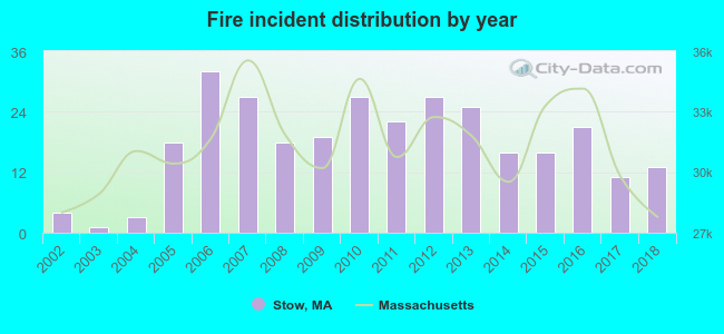 Based on the data from the years 2002 - 2018 the average number of fires per year is 18. The highest number of reported fire incidents - 32 took place in 2006, and the least - 1 in 2003. The data has a rising trend.
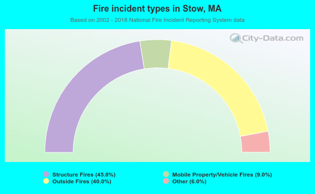 When looking into fire subcategories, the most incidents belonged to: Structure Fires (45.0%), and Outside Fires (40.0%).
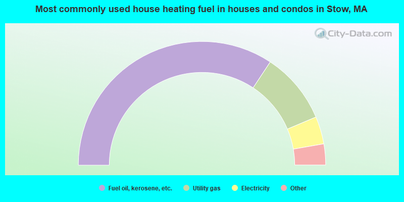
- 68.6%Fuel oil, kerosene, etc.
- 18.7%Utility gas
- 7.2%Electricity
- 3.0%Wood
- 2.1%Bottled, tank, or LP gas
- 0.4%Other fuel
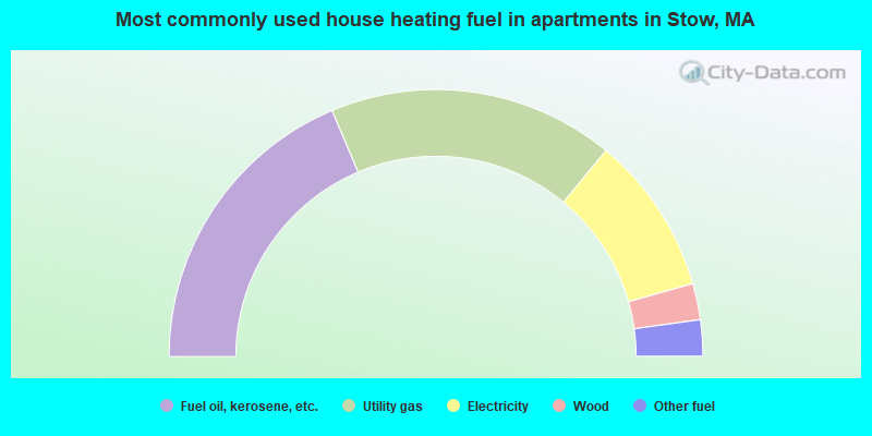
- 37.3%Fuel oil, kerosene, etc.
- 34.7%Utility gas
- 19.2%Electricity
- 4.4%Wood
- 4.4%Other fuel
Stow compared to Massachusetts state average:
- Median household income above state average.
- Median house value above state average.
- Unemployed percentage significantly below state average.
- Black race population percentage significantly below state average.
- Hispanic race population percentage significantly below state average.
- Median age above state average.
- Foreign-born population percentage significantly below state average.
- Renting percentage significantly below state average.
- Length of stay since moving in significantly above state average.
- Number of rooms per house significantly below state average.
- House age significantly below state average.
- Percentage of population with a bachelor's degree or higher above state average.
Stow on our top lists:
- #3 on the list of "Top 101 cities with largest percentage of males in occupations: engineers (population 5,000+)"
- #3 on the list of "Top 101 cities with largest percentage of females in occupations: life and physical scientists (population 5,000+)"
- #3 on the list of "Top 101 cities with largest percentage of males in industries: professional and commercial equipment and supplies merchant wholesalers (population 5,000+)"
- #5 on the list of "Top 101 cities with largest percentage of males in industries: radio, tv, and computer stores (population 5,000+)"
- #6 on the list of "Top 101 cities with largest percentage of females in industries: radio, tv, and computer stores (population 5,000+)"
- #7 on the list of "Top 101 cities with largest percentage of females in occupations: accountants and auditors (population 5,000+)"
- #7 on the list of "Top 101 cities with largest percentage of females in occupations: librarians, curators, and archivists (population 5,000+)"
- #9 on the list of "Top 101 cities with largest percentage of males in occupations: librarians, curators, and archivists (population 5,000+)"
- #9 on the list of "Top 101 cities with largest percentage of females in industries: sewing, needlework, and piece goods stores (population 5,000+)"
- #14 on the list of "Top 101 cities with largest percentage of males in industries: data processing, libraries, and other information services (population 5,000+)"
- #15 on the list of "Top 101 cities with largest percentage of males in occupations: computer specialists (population 5,000+)"
- #17 on the list of "Top 101 cities with largest percentage of females in industries: office supplies and stationery stores (population 5,000+)"
- #34 on the list of "Top 101 cities with largest percentage of males in industries: computer and electronic products (population 5,000+)"
- #46 on the list of "Top 101 cities with largest percentage of females in industries: data processing, libraries, and other information services (population 5,000+)"
- #57 on the list of "Top 101 cities with largest percentage of females in industries: private households (population 5,000+)"
- #60 on the list of "Top 100 safest cities (lowest city-data.com crime index) (pop. 5,000+)"
- #77 on the list of "Top 101 cities with largest percentage of males in industries: miscellaneous manufacturing (population 5,000+)"
- #77 on the list of "Top 101 cities with largest percentage of females in industries: professional, scientific, and technical services (population 5,000+)"
- #88 on the list of "Top 101 cities with largest percentage of males in industries: publishing, and motion picture and sound recording industries (population 5,000+)"
- #88 on the list of "Top 101 cities with largest percentage of females in industries: retail florists (population 5,000+)"
- #4 on the list of "Top 101 counties with the most Orthodox adherents"
- #7 on the list of "Top 101 counties with the most Catholic adherents"
- #7 on the list of "Top 101 counties with the most Mainline Protestant congregations"
- #7 on the list of "Top 101 counties with the most Orthodox congregations"
- #8 on the list of "Top 101 counties with the lowest percentage of residents that keep firearms around their homes"

|
|
Total of 834 patent applications in 2008-2024.