Garfield, Wisconsin
Submit your own pictures of this town and show them to the world
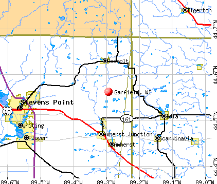
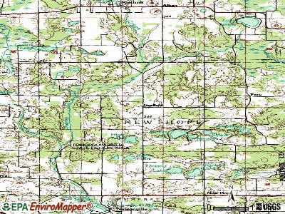
- OSM Map
- General Map
- Google Map
- MSN Map
Population change since 2000: +17.3%
 |
| Males: 888 | |
| Females: 804 |
| Median resident age: | 41.3 years |
| Wisconsin median age: | 42.6 years |
Zip codes: 54001.
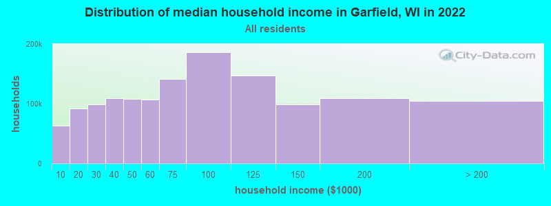
| Garfield: | $84,671 |
| WI: | $70,996 |
Estimated per capita income in 2022: $43,064 (it was $21,834 in 2000)
Garfield town income, earnings, and wages data
Estimated median house or condo value in 2022: $296,847 (it was $122,200 in 2000)
| Garfield: | $296,847 |
| WI: | $252,800 |
Mean prices in 2022: all housing units: $277,838; detached houses: $292,280; townhouses or other attached units: $273,047; in 2-unit structures: $342,285; in 3-to-4-unit structures: $199,123; in 5-or-more-unit structures: $285,633; mobile homes: $95,707; occupied boats, rvs, vans, etc.: $119,484
Detailed information about poverty and poor residents in Garfield, WI


- 1,60194.6%White alone
- 593.5%Hispanic
- 150.9%Two or more races
- 90.5%American Indian alone
- 30.2%Black alone
- 40.2%Asian alone
- 10.06%Native Hawaiian and Other
Pacific Islander alone
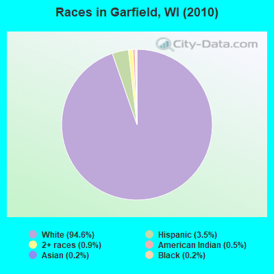
Races in Garfield detailed stats: ancestries, foreign born residents, place of birth
 Recent articles from our blog. Our writers, many of them Ph.D. graduates or candidates, create easy-to-read articles on a wide variety of topics.

 | Wisconsin Governor’s Race 2018 (434 replies) |
| Fellow Milwaukeeans thoughts on Chicago? (79 replies) |
| moving to Madison,Wi from Jacksonville,Fl (20 replies) |
| Is Milwaukee A Dangerous City (214 replies) |
| Which Milwaukee Suburb/Neighborhood? (3 replies) |
| Why In The Heck... (24 replies) |
Latest news from Garfield, WI collected exclusively by city-data.com from local newspapers, TV, and radio stations
Ancestries: German (33.3%), Norwegian (29.8%), Irish (11.4%), Swedish (9.9%), English (5.7%), French (4.1%).
Current Local Time: CST time zone
Elevation: 1147 feet
Land area: 33.0 square miles.
Population density: 51 people per square mile (very low).
25 residents are foreign born
| This town: | 1.7% |
| Wisconsin: | 3.6% |
| Garfield town: | 1.5% ($1,795) |
| Wisconsin: | 2.0% ($2,245) |
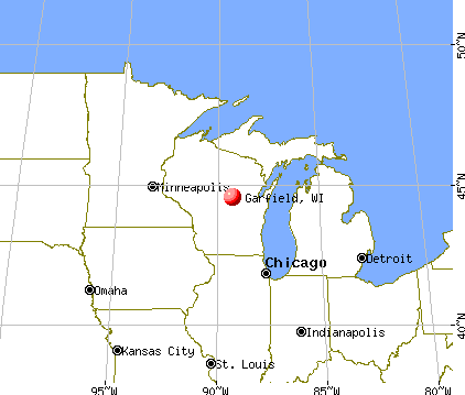
Nearest city with pop. 50,000+: St. Paul, MN  (40.1 miles , pop. 287,151).
Nearest city with pop. 1,000,000+: Chicago, IL (341.1 miles , pop. 2,896,016).
Nearest cities:
), ), ), ), Latitude: 45.33 N, Longitude: 92.49 W
Area code commonly used in this area: 715

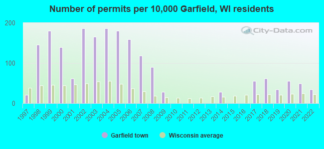
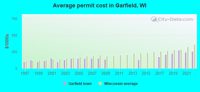
Single-family new house construction building permits:
- 2022: 5 buildings, average cost: $260,100
- 2021: 7 buildings, average cost: $244,800
- 2020: 8 buildings, average cost: $278,400
- 2019: 5 buildings, average cost: $226,000
- 2018: 9 buildings, average cost: $214,500
- 2017: 8 buildings, average cost: $177,000
- 2014: 4 buildings, average cost: $135,000
- 2009: 4 buildings, average cost: $138,700
- 2008: 13 buildings, average cost: $150,800
- 2007: 17 buildings, average cost: $150,800
- 2006: 23 buildings, average cost: $150,800
- 2005: 26 buildings, average cost: $150,800
- 2004: 27 buildings, average cost: $150,800
- 2003: 24 buildings, average cost: $129,200
- 2002: 27 buildings, average cost: $103,600
- 2001: 9 buildings, average cost: $155,800
- 2000: 20 buildings, average cost: $114,100
- 1999: 26 buildings, average cost: $101,600
- 1998: 21 buildings, average cost: $128,300
- 1997: 3 buildings, average cost: $103,300
| Here: | 4.6% |
| Wisconsin: | 2.7% |
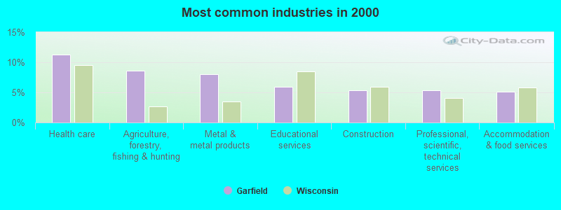
- Health care (11.3%)
- Agriculture, forestry, fishing & hunting (8.6%)
- Metal & metal products (8.0%)
- Educational services (5.9%)
- Construction (5.3%)
- Professional, scientific, technical services (5.3%)
- Accommodation & food services (5.2%)
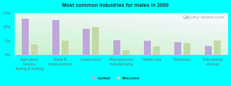
- Agriculture, forestry, fishing & hunting (13.1%)
- Metal & metal products (12.6%)
- Construction (9.5%)
- Miscellaneous manufacturing (5.4%)
- Health care (5.1%)
- Machinery (4.6%)
- Educational services (3.3%)
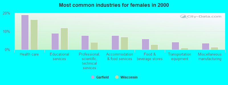
- Health care (19.1%)
- Educational services (9.1%)
- Professional, scientific, technical services (7.8%)
- Accommodation & food services (7.8%)
- Food & beverage stores (5.8%)
- Transportation equipment (4.2%)
- Miscellaneous manufacturing (3.6%)
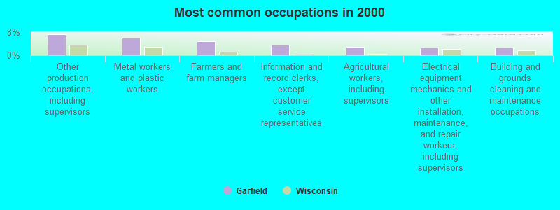
- Other production occupations, including supervisors (7.2%)
- Metal workers and plastic workers (6.0%)
- Farmers and farm managers (4.7%)
- Information and record clerks, except customer service representatives (3.6%)
- Agricultural workers, including supervisors (2.9%)
- Electrical equipment mechanics and other installation, maintenance, and repair workers, including supervisors (2.7%)
- Building and grounds cleaning and maintenance occupations (2.7%)
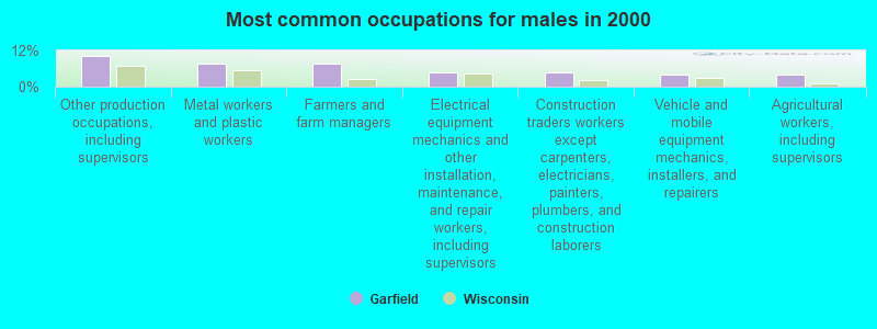
- Other production occupations, including supervisors (10.3%)
- Metal workers and plastic workers (7.7%)
- Farmers and farm managers (7.5%)
- Electrical equipment mechanics and other installation, maintenance, and repair workers, including supervisors (4.9%)
- Construction traders workers except carpenters, electricians, painters, plumbers, and construction laborers (4.6%)
- Vehicle and mobile equipment mechanics, installers, and repairers (4.1%)
- Agricultural workers, including supervisors (3.9%)
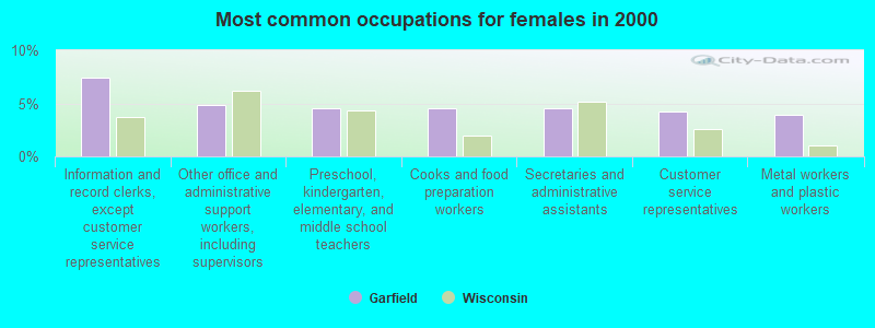
- Information and record clerks, except customer service representatives (7.4%)
- Other office and administrative support workers, including supervisors (4.9%)
- Preschool, kindergarten, elementary, and middle school teachers (4.5%)
- Cooks and food preparation workers (4.5%)
- Secretaries and administrative assistants (4.5%)
- Customer service representatives (4.2%)
- Metal workers and plastic workers (3.9%)
Average climate in Garfield, Wisconsin
Based on data reported by over 4,000 weather stations


Tornado activity:
Garfield-area historical tornado activity is near Wisconsin state average. It is 7% greater than the overall U.S. average.
On 6/4/1958, a category F5 (max. wind speeds 261-318 mph) tornado 30.9 miles away from the Garfield town center killed 21 people and injured 74 people and caused between $5,000,000 and $50,000,000 in damages.
On 5/21/1957, a category F4 (max. wind speeds 207-260 mph) tornado 25.1 miles away from the town center injured 2 people and caused between $5000 and $50,000 in damages.
Earthquake activity:
Garfield-area historical earthquake activity is significantly above Wisconsin state average. It is 62% smaller than the overall U.S. average.On 7/9/1975 at 14:54:15, a magnitude 4.6 (4.6 MB, Class: Light, Intensity: IV - V) earthquake occurred 173.7 miles away from the city center
On 6/5/1993 at 01:24:53, a magnitude 4.1 (4.1 LG, Depth: 6.2 mi) earthquake occurred 185.8 miles away from Garfield center
On 3/4/1983 at 06:32:18, a magnitude 4.6 (4.4 MB, 4.6 LG, 4.4 ML) earthquake occurred 348.3 miles away from the city center
On 10/20/1995 at 15:57:18, a magnitude 3.7 (3.7 LG, Depth: 3.1 mi, Class: Light, Intensity: II - III) earthquake occurred 214.1 miles away from the city center
On 2/7/2020 at 18:30:28, a magnitude 3.3 (3.3 ML) earthquake occurred 148.9 miles away from Garfield center
On 1/9/2020 at 18:16:48, a magnitude 3.3 (3.3 MB) earthquake occurred 153.5 miles away from Garfield center
Magnitude types: regional Lg-wave magnitude (LG), body-wave magnitude (MB), local magnitude (ML)
Natural disasters:
The number of natural disasters in Polk County (9) is smaller than the US average (15).Major Disasters (Presidential) Declared: 5
Emergencies Declared: 3
Causes of natural disasters: Floods: 5, Storms: 4, Tornadoes: 4, Winds: 2, Drought: 1, Hurricane: 1, Other: 1 (Note: some incidents may be assigned to more than one category).
Hospitals and medical centers near Garfield:
- AMERY REGIONAL MEDICAL CENTER (Hospital, about 7 miles away; AMERY, WI)
- GOLDEN AGE MANOR (Nursing Home, about 7 miles away; AMERY, WI)
- AMERY REG MED CTR Critical Access Hospitals (about 7 miles away; AMERY, WI)
- CENTURIA NURSING HOME (Nursing Home, about 9 miles away; CENTURIA, WI)
- LADD MEMORIAL HOSPTIAL, INC Critical Access Hospitals (about 9 miles away; OSCEOLA, WI)
- CHRISTIAN COMMUNITY HOME OF OSCEOLA, INC (Nursing Home, about 9 miles away; OSCEOLA, WI)
- GOOD SAMARITAN SOCIETY-ST CROIX VALLEY (Nursing Home, about 9 miles away; ST CROIX FALLS, WI)
Colleges/universities with over 2000 students nearest to Garfield:
- Century College (about 32 miles; White Bear Lake, MN; Full-time enrollment: 7,393)
- University of Wisconsin-River Falls (about 34 miles; River Falls, WI; FT enrollment: 5,868)
- Bethel University (about 38 miles; Saint Paul, MN; FT enrollment: 4,061)
- Metropolitan State University (about 39 miles; Saint Paul, MN; FT enrollment: 6,159)
- University of Northwestern-St Paul (about 40 miles; Saint Paul, MN; FT enrollment: 2,680)
- Wisconsin Indianhead Technical College (about 40 miles; Shell Lake, WI; FT enrollment: 2,414)
- Saint Paul College (about 41 miles; Saint Paul, MN; FT enrollment: 4,778)
Points of interest:
Notable location: Dresser - Osceola - Garfield Fire Association Garfield Station (A). Display/hide its location on the map
Churches in Garfield include: Trinity Church (A), El Salem Church (B). Display/hide their locations on the map
Cemetery: El Salem Cemetery (1). Display/hide its location on the map
Lakes: Mud Lake (A), Ox Lake (B), Pine Lake (C), Badger Lake (D), Basswood Lake (E), Bear Lake (F), Big Horseshoe Lake (G), Big Lake (H). Display/hide their locations on the map
Streams, rivers, and creeks: Balsam Branch (A). Display/hide its location on the map
Park in Garfield: Balsam Branch State Wildlife Area (1). Display/hide its location on the map
| This town: | 2.7 people |
| Wisconsin: | 2.4 people |
| This town: | 79.3% |
| Whole state: | 64.4% |
| This town: | 6.1% |
| Whole state: | 7.3% |
Likely homosexual households (counted as self-reported same-sex unmarried-partner households)
- Lesbian couples: 0.2% of all households
- Gay men: 0.0% of all households
| This town: | 2.8% |
| Whole state: | 8.7% |
| This town: | 1.5% |
| Whole state: | 3.7% |
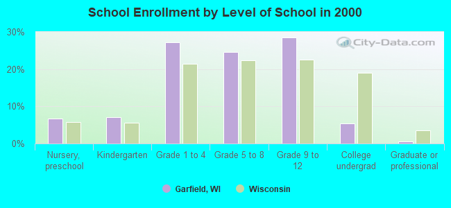
For population 15 years and over in Garfield:
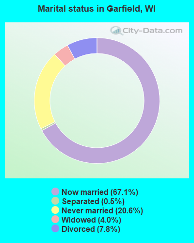
- Never married: 20.6%
- Now married: 67.1%
- Separated: 0.5%
- Widowed: 4.0%
- Divorced: 7.8%
For population 25 years and over in Garfield:
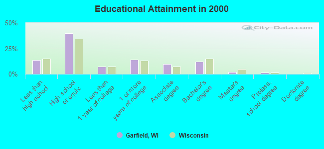
- High school or higher: 86.4%
- Bachelor's degree or higher: 16.1%
- Graduate or professional degree: 3.7%
- Unemployed: 2.5%
- Mean travel time to work (commute): 28.9 minutes
| Here: | 8.8 |
| Wisconsin average: | 11.0 |
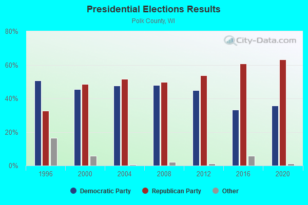
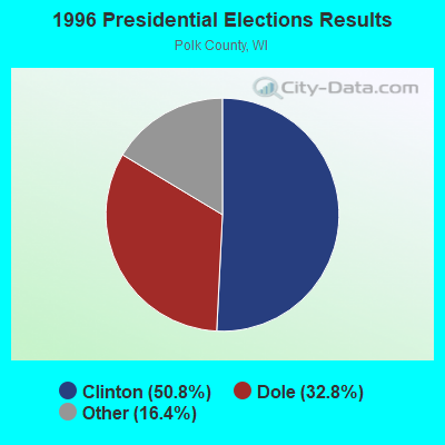
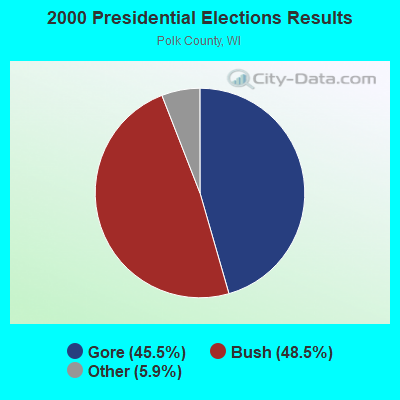

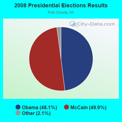
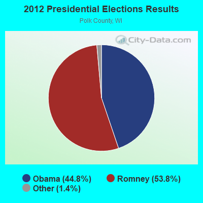
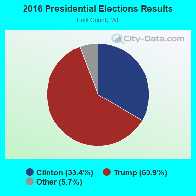
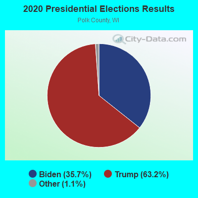
Graphs represent county-level data. Detailed 2008 Election Results
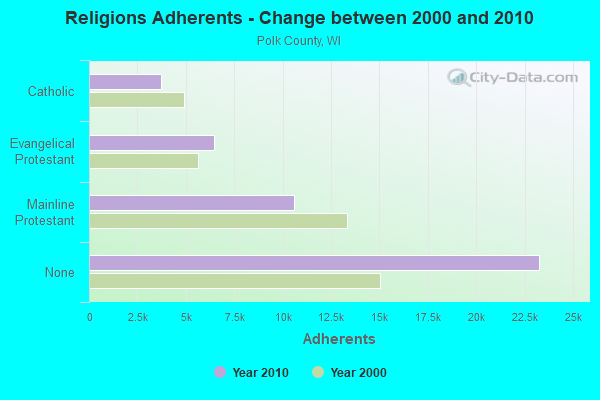
Religion statistics for Garfield, WI (based on Polk County data)
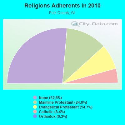
| Religion | Adherents | Congregations |
|---|---|---|
| Mainline Protestant | 10,596 | 37 |
| Evangelical Protestant | 6,480 | 39 |
| Catholic | 3,716 | 5 |
| Orthodox | 130 | 1 |
| Other | 15 | 3 |
| None | 23,268 | - |
Food Environment Statistics:
| This county: | 2.49 / 10,000 pop. |
| State: | 1.86 / 10,000 pop. |
| This county: | 0.23 / 10,000 pop. |
| Wisconsin: | 0.38 / 10,000 pop. |
| This county: | 5.65 / 10,000 pop. |
| State: | 4.12 / 10,000 pop. |
| This county: | 8.37 / 10,000 pop. |
| Wisconsin: | 8.64 / 10,000 pop. |
| This county: | 8.0% |
| State: | 7.6% |
| Polk County: | 26.9% |
| State: | 27.5% |
| This county: | 9.1% |
| Wisconsin: | 13.0% |
Strongest AM radio stations in Garfield:
- WXCE (1260 AM; 5 kW; AMERY, WI; Owner: LAKE COUNTRY BROADCASTING CORPORATION)
- WCTS (1030 AM; 50 kW; MAPLEWOOD, MN; Owner: CNTL. BAPT. THEO/AL SEMI MINNEAPOLIS)
- WCCO (830 AM; 50 kW; MINNEAPOLIS, MN; Owner: INFINITY MEDIA CORPORATION)
- KSTP (1500 AM; 50 kW; ST. PAUL, MN; Owner: KSTP-AM, LLC (DELAWARE))
- KTIS (900 AM; 25 kW; MINNEAPOLIS, MN; Owner: NORTHWESTERN COLLEGE)
- WDGY (630 AM; 8 kW; HUDSON, WI; Owner: 630 RADIO, INCORPORATED)
- KFAN (1130 AM; 50 kW; MINNEAPOLIS, MN; Owner: AMFM RADIO LICENSES, L.L.C.)
- WIXK (1590 AM; daytime; 5 kW; NEW RICHMOND, WI; Owner: WIXK-AM, LLC)
- WEBC (560 AM; 50 kW; DULUTH, MN)
- WMGT (1220 AM; 5 kW; STILLWATER, MN; Owner: ENDURANCE BROADCASTING, LLC)
- WMEQ (880 AM; 10 kW; MENOMONIE, WI; Owner: CAPSTAR TX LIMITED PARTNERSHIP)
- KUOM (770 AM; daytime; 5 kW; MINNEAPOLIS, MN)
- WAQE (1090 AM; daytime; 5 kW; RICE LAKE, WI; Owner: TKC, INC.)
Strongest FM radio stations in Garfield:
- WXPT (104.1 FM; ST. LOUIS PARK, MN; Owner: THE AUDIO HOUSE, INC.)
- KNOW-FM (91.1 FM; MINNEAPOLIS-ST. PAUL, MN; Owner: MINNESOTA PUBLIC RADIO)
- WLTE (102.9 FM; MINNEAPOLIS, MN; Owner: INFINITY MEDIA CORPORATION)
- KSTP-FM (94.5 FM; ST. PAUL, MN; Owner: KSTP-FM, LLC, A DELAWARE LLC)
- KEEY-FM (102.1 FM; ST. PAUL, MN; Owner: AMFM RADIO LICENSES, L.L.C.)
- KTIS-FM (98.5 FM; MINNEAPOLIS, MN; Owner: NORTHWESTERN COLLEGE)
- WHWC (88.3 FM; MENOMONIE, WI; Owner: STATE OF WISCONSIN - EDUCATIONAL COMMUNICATIONS BOARD)
- KDWB-FM (101.3 FM; RICHFIELD, MN; Owner: AMFM RADIO LICENSES, L.L.C.)
- KQRS-FM (92.5 FM; GOLDEN VALLEY, MN; Owner: KQRS, Inc.)
- KSJN (99.5 FM; MINNEAPOLIS, MN; Owner: MINNESOTA PUBLIC RADIO)
- KXXR (93.7 FM; MINNEAPOLIS, MN; Owner: KQRS, INC.)
- WLMX-FM (104.9 FM; BALSAM LAKE, WI; Owner: QUARNSTROM MEDIA GROUP, LLC)
- KQQL (107.9 FM; ANOKA, MN; Owner: AMFM RADIO LICENSES, L.L.C.)
- KJZI (100.3 FM; MINNEAPOLIS, MN; Owner: AMFM RADIO LICENSES, L.L.C.)
- KMKL (90.3 FM; NORTH BRANCH, MN; Owner: EDUCATIONAL MEDIA FOUNDATION)
- WFMP (107.1 FM; COON RAPIDS, MN; Owner: WFMP-FM, LLC)
TV broadcast stations around Garfield:
- KMSP-TV (Channel 9; MINNEAPOLIS, MN; Owner: FOX TELEVISION STATIONS, INC.)
- KARE (Channel 11; MINNEAPOLIS, MN; Owner: MULTIMEDIA HOLDINGS CORPORATION)
- KSTP-TV (Channel 5; ST. PAUL, MN; Owner: HUBBARD BROADCASTING, INC.)
- KTCA-TV (Channel 2; ST. PAUL, MN; Owner: TWIN CITIES PUBLIC TELEVISION, INC.)
- WCCO-TV (Channel 4; MINNEAPOLIS, MN; Owner: CBS BROADCASTING INC.)
- KTCI-TV (Channel 17; ST. PAUL, MN; Owner: TWIN CITIES PUBLIC TELEVISION, INC.)
- KSTC-TV (Channel 45; MINNEAPOLIS, MN; Owner: HUBBARD BROADCASTING, INC.)
- KMWB (Channel 23; MINNEAPOLIS, MN; Owner: KLGT LICENSEE, LLC)
- WFTC (Channel 29; MINNEAPOLIS, MN; Owner: FOX TELEVISION STATIONS, INC.)
- WHWC-TV (Channel 28; MENOMONIE, WI; Owner: STATE OF WISCONSIN - EDUCATIONAL COMMUNICATIONS BOARD)
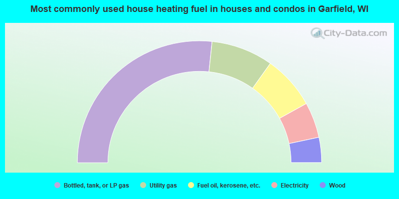
- 53.3%Bottled, tank, or LP gas
- 16.4%Utility gas
- 14.2%Fuel oil, kerosene, etc.
- 9.4%Electricity
- 6.7%Wood
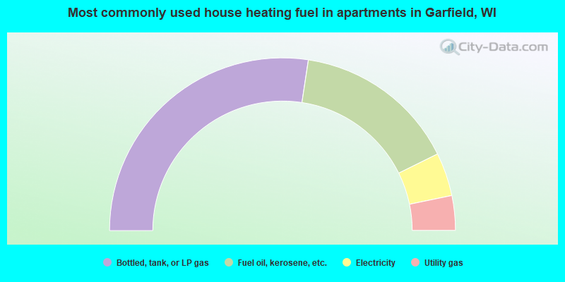
- 54.8%Bottled, tank, or LP gas
- 30.6%Fuel oil, kerosene, etc.
- 8.1%Electricity
- 6.5%Utility gas
Garfield compared to Wisconsin state average:
- Unemployed percentage significantly below state average.
- Black race population percentage significantly below state average.
- Hispanic race population percentage below state average.
- Foreign-born population percentage significantly below state average.
- Renting percentage below state average.
- Length of stay since moving in significantly above state average.
- Number of rooms per house significantly below state average.
- House age significantly below state average.
- Number of college students significantly below state average.