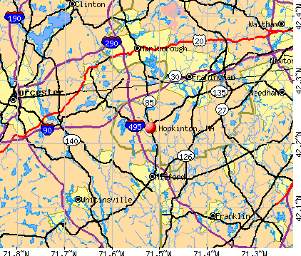
Hopkinton, Massachusetts
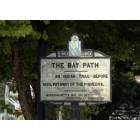
Hopkinton: Main Street in Hopkinton, originally the Bay Path many years ago.

Hopkinton: Vintage Hopkinton fire engine used in the Independence Day Parade 2006.
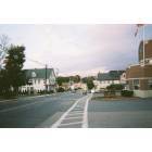
Hopkinton: Hopkinton center (facing east)... September '06
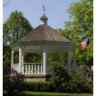
Hopkinton: A bandstand/gazebo in the Hopkinton Town Commons.
- add
your
Submit your own pictures of this place and show them to the world
- OSM Map
- General Map
- Google Map
- MSN Map
Population change since 2000: -3.0%
| Males: 1,082 | |
| Females: 1,468 |
| Median resident age: | 53.4 years |
| Massachusetts median age: | 40.3 years |
Zip codes: 01748.
| Hopkinton: | $164,917 |
| MA: | $94,488 |
Estimated per capita income in 2022: $117,540 (it was $23,878 in 2000)
Hopkinton CDP income, earnings, and wages data
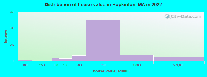
Estimated median house or condo value in 2022: $636,849 (it was $209,900 in 2000)
| Hopkinton: | $636,849 |
| MA: | $534,700 |
Mean prices in 2022: all housing units: $796,617; detached houses: $834,667; townhouses or other attached units: $772,440; in 2-unit structures: $786,250; in 3-to-4-unit structures: $655,835; in 5-or-more-unit structures: $590,321; mobile homes: $144,935
Median gross rent in 2022: $1,582.
(2.8% for White Non-Hispanic residents, 50.0% for Black residents, 12.0% for Hispanic or Latino residents, 3.6% for two or more races residents)
Detailed information about poverty and poor residents in Hopkinton, MA


Compare current foreclosures near Hopkinton, MA:
| Photo | Address | Area | Beds / Baths | Price | Details |
|---|---|---|---|---|---|

|
#1
Everett Cir
Hopkinton, MA 01748
|
5,180 sq. feet
|
3 baths 4 beds |
show details | |

|
#2
Hayden Rowe St
Hopkinton, MA 01748
|
1,336 sq. feet
|
1 baths 2 beds |
show details | |

|
#3
Oakhurst Rd
Hopkinton, MA 01748
|
1,008 sq. feet
|
1 baths 2 beds |
show details | |

|
#4
Church St
Hopkinton, MA 01748
|
5,497 sq. feet
|
2 baths 4 beds |
show details | |

|
#5
Hayden Rowe St
Hopkinton, MA 01748
|
937 sq. feet
|
1 baths 3 beds |
show details | |

|
#6
Cole Dr # 8
Hopkinton, MA 01748
|
2,006 sq. feet
|
2 baths 3 beds |
show details | |

|
#7
Cole Dr
Hopkinton, MA 01748
|
2,006 sq. feet
|
2 baths 3 beds |
show details | |

|
#8
Everett Cir
Hopkinton, MA 01748
|
5,180 sq. feet
|
3 baths 4 beds |
show details | |

|
#9
Granite St
Hopkinton, MA 01748
|
1,961 sq. feet
|
2 baths 3 beds |
show details | |

|
#10
Constitution Ct, Apt 417
Hopkinton, MA 01748
|
- sq. feet
|
- baths - beds |
show details |
| Photo | Address | Area | Beds / Baths | Price | Details |
|---|---|---|---|---|---|

|
#11
Cook Rd
Cumberland, RI 02864
|
2,050 sq. feet
|
2 baths 4 beds |
$749,500
|
show details |

|
#12
Mount Pleasant Rd
Harrisville, RI 02830
|
1,232 sq. feet
|
1 baths 3 beds |
$449,900
|
show details |

|
#13
Stillman St
Framingham, MA 01702
|
1,122 sq. feet
|
1 baths 2 beds |
$440,000
|
show details |

|
#14
W Lake St
Worcester, MA 01603
|
3,266 sq. feet
|
2 baths 5 beds |
show details | |

|
#15
Briarwood Rd
Framingham, MA 01701
|
1,248 sq. feet
|
2 baths 3 beds |
show details | |

|
#16
Grove St
Woonsocket, RI 02895
|
2,534 sq. feet
|
3 baths 6 beds |
show details | |

|
#17
Laurelwood Dr # No
Hopedale, MA 01747
|
1,440 sq. feet
|
1 baths 2 beds |
show details | |

|
#18
Richards St
Worcester, MA 01603
|
1,144 sq. feet
|
1 baths 3 beds |
show details | |

|
#19
Victoria Cir
Norwood, MA 02062
|
2,980 sq. feet
|
3 baths 5 beds |
show details | |

|
#20
Great Rd
Stow, MA 01775
|
2,026 sq. feet
|
2 baths 3 beds |
show details |
| Photo | Address | Area | Beds / Baths | Price | Details |
|---|---|---|---|---|---|

|
#21
Sugar Rd
Bolton, MA 01740
|
1,988 sq. feet
|
2 baths 3 beds |
show details | |

|
#22
Deer Path Apt 5
Maynard, MA 01754
|
1,540 sq. feet
|
1 baths 2 beds |
show details | |

|
#23
Granville Ave
Worcester, MA 01606
|
1,354 sq. feet
|
1 baths 3 beds |
show details | |

|
#24
Marks Way
Maynard, MA 01754
|
2,596 sq. feet
|
2 baths 4 beds |
show details | |

|
#25
1/2 Putnam Hill Road
Sutton, MA 01590
|
1,415 sq. feet
|
1 baths 3 beds |
show details | |

|
#26
Pocasset Ave
Worcester, MA 01606
|
2,090 sq. feet
|
3 baths 3 beds |
show details | |

|
#27
Old Bolton Rd
Hudson, MA 01749
|
1,244 sq. feet
|
1 baths 3 beds |
show details | |

|
#28
Old Mill Rd
Shrewsbury, MA 01545
|
2,110 sq. feet
|
2 baths 3 beds |
show details | |

|
#29
Mallard Dr
Medway, MA 02053
|
2,024 sq. feet
|
2 baths 5 beds |
show details | |

|
#30
Glendale Ave
Uxbridge, MA 01569
|
1,302 sq. feet
|
2 baths 4 beds |
show details |
| Photo | Address | Area | Beds / Baths | Price | Details |
|---|---|---|---|---|---|

|
#31
Cedar St
Ashland, MA 01721
|
2,756 sq. feet
|
3 baths 4 beds |
show details | |

|
#32
Old Millbury Rd
Oxford, MA 01540
|
1,736 sq. feet
|
2 baths 3 beds |
show details | |

|
#33
Everton Ave
Worcester, MA 01604
|
2,310 sq. feet
|
1 baths 4 beds |
show details | |

|
#34
Jean St
Blackstone, MA 01504
|
1,808 sq. feet
|
2 baths 3 beds |
show details | |

|
#35
Heywood St
Worcester, MA 01604
|
1,204 sq. feet
|
1 baths 3 beds |
show details | |

|
#36
Dartmouth St
Worcester, MA 01604
|
3,963 sq. feet
|
3 baths 9 beds |
show details | |

|
#37
Canavan Cir
Needham, MA 02492
|
3,180 sq. feet
|
3 baths 4 beds |
show details | |

|
#38
Orchard St
Blackstone, MA 01504
|
1,764 sq. feet
|
2 baths 3 beds |
show details | |

|
#39
Massasoit Rd
Worcester, MA 01604
|
990 sq. feet
|
1 baths 2 beds |
show details | |

|
#40
Oakview St # 7
Worcester, MA 01605
|
902 sq. feet
|
1 baths 3 beds |
show details |
| Photo | Address | Area | Beds / Baths | Price | Details |
|---|---|---|---|---|---|

|
#41
Ridge Hill Rd
Sudbury, MA 01776
|
2,288 sq. feet
|
2 baths 4 beds |
show details | |

|
#42
Crowningshield Rd
Worcester, MA 01604
|
1,037 sq. feet
|
1 baths 3 beds |
show details | |

|
#43
Pilgrim Ave
Worcester, MA 01604
|
2,000 sq. feet
|
2 baths 4 beds |
show details | |

|
#44
Bleeker St
Worcester, MA 01604
|
937 sq. feet
|
1 baths 4 beds |
show details | |

|
#45
W Hartford Ave
Uxbridge, MA 01569
|
2,328 sq. feet
|
3 baths 4 beds |
show details | |

|
#46
Bowker St
Worcester, MA 01604
|
840 sq. feet
|
1 baths 2 beds |
show details | |

|
#47
Derby Rd
Berlin, MA 01503
|
1,296 sq. feet
|
1 baths 2 beds |
show details | |

|
#48
Meachen Ln
Sudbury, MA 01776
|
4,759 sq. feet
|
4 baths 5 beds |
show details | |

|
#49
Northboro St
Worcester, MA 01604
|
1,284 sq. feet
|
2 baths 3 beds |
show details | |

|
Check over 1 million property listings on Foreclosure.com!
|
browse all offers | |||


- 2,91988.9%White alone
- 1705.2%Two or more races
- 591.8%Hispanic
- 561.7%Asian alone
- 90.3%Black alone
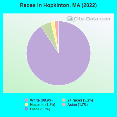
Races in Hopkinton detailed stats: ancestries, foreign born residents, place of birth
According to our research of Massachusetts and other state lists, there was 1 registered sex offender living in Hopkinton, Massachusetts as of April 27, 2024.
The ratio of all residents to sex offenders in Hopkinton is 2,833 to 1.
The ratio of registered sex offenders to all residents in this city is lower than the state average.
Type |
2009 |
2010 |
2011 |
2012 |
2013 |
2014 |
2015 |
2016 |
2017 |
2018 |
2019 |
2020 |
2021 |
2022 |
|---|---|---|---|---|---|---|---|---|---|---|---|---|---|---|
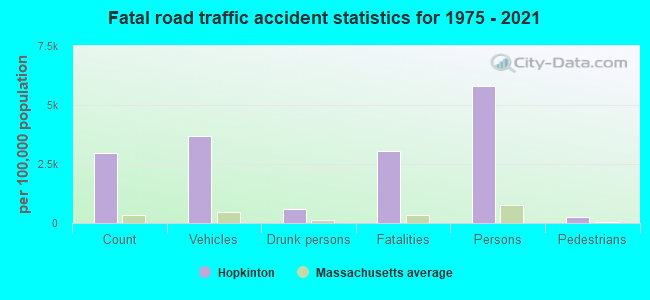
| Murders (per 100,000) | 0 (0.0) | 0 (0.0) | 0 (0.0) | 0 (0.0) | 0 (0.0) | 0 (0.0) | 0 (0.0) | 0 (0.0) | 0 (0.0) | 0 (0.0) | 0 (0.0) | 0 (0.0) | 0 (0.0) | 0 (0.0) |
| Rapes (per 100,000) | 0 (0.0) | 1 (6.7) | 0 (0.0) | 0 (0.0) | 1 (6.4) | 0 (0.0) | 0 (0.0) | 0 (0.0) | 0 (0.0) | 0 (0.0) | 0 (0.0) | 0 (0.0) | 0 (0.0) | 3 (15.6) |
| Robberies (per 100,000) | 1 (6.8) | 0 (0.0) | 0 (0.0) | 1 (6.6) | 0 (0.0) | 0 (0.0) | 0 (0.0) | 0 (0.0) | 0 (0.0) | 1 (5.4) | 0 (0.0) | 0 (0.0) | 0 (0.0) | 0 (0.0) |
| Assaults (per 100,000) | 3 (20.5) | 1 (6.7) | 0 (0.0) | 1 (6.6) | 2 (12.7) | 1 (6.2) | 0 (0.0) | 2 (11.8) | 0 (0.0) | 1 (5.4) | 0 (0.0) | 5 (26.6) | 15 (78.2) | 27 (140.8) |
| Burglaries (per 100,000) | 8 (54.7) | 0 (0.0) | 2 (13.3) | 0 (0.0) | 6 (38.2) | 1 (6.2) | 1 (6.0) | 1 (5.9) | 2 (11.5) | 0 (0.0) | 1 (5.4) | 0 (0.0) | 2 (10.4) | 2 (10.4) |
| Thefts (per 100,000) | 91 (621.9) | 97 (649.9) | 66 (439.5) | 92 (604.7) | 86 (548.2) | 41 (252.9) | 52 (312.0) | 63 (371.5) | 57 (328.6) | 29 (156.6) | 28 (150.7) | 27 (143.6) | 27 (140.7) | 45 (234.6) |
| Auto thefts (per 100,000) | 3 (20.5) | 1 (6.7) | 0 (0.0) | 2 (13.1) | 1 (6.4) | 1 (6.2) | 0 (0.0) | 0 (0.0) | 0 (0.0) | 6 (32.4) | 1 (5.4) | 2 (10.6) | 3 (15.6) | 0 (0.0) |
| Arson (per 100,000) | 0 (0.0) | 0 (0.0) | 0 (0.0) | 0 (0.0) | 1 (6.4) | 0 (0.0) | 0 (0.0) | 0 (0.0) | 0 (0.0) | 0 (0.0) | 0 (0.0) | 0 (0.0) | 0 (0.0) | 1 (5.2) |
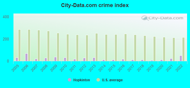
| City-Data.com crime index | 36.5 | 33.2 | 18.5 | 28.5 | 32.8 | 12.3 | 12.9 | 17.6 | 13.9 | 11.6 | 6.8 | 11.9 | 23.2 | 50.8 |
The City-Data.com crime index weighs serious crimes and violent crimes more heavily. Higher means more crime, U.S. average is 246.1. It adjusts for the number of visitors and daily workers commuting into cities.
Crime rate in Hopkinton detailed stats: murders, rapes, robberies, assaults, burglaries, thefts, arson
Full-time law enforcement employees in 2021, including police officers: 34 (24 officers - 20 male; 4 female).
| Officers per 1,000 residents here: | 1.25 |
| Massachusetts average: | 2.53 |
 Recent articles from our blog. Our writers, many of them Ph.D. graduates or candidates, create easy-to-read articles on a wide variety of topics.


Latest news from Hopkinton, MA collected exclusively by city-data.com from local newspapers, TV, and radio stations
Hopkinton, MA City Guides:
Ancestries: English (50.8%), Irish (10.5%), Brazilian (5.2%), Swedish (4.3%), American (3.8%), Italian (2.2%).
Current Local Time: EST time zone
Incorporated in 1715
Elevation: 410 feet
Land area: 1.66 square miles.
Population density: 1,537 people per square mile (low).
199 residents are foreign born (2.7% Latin America, 1.5% Asia, 1.2% Europe).
| This place: | 6.1% |
| Massachusetts: | 17.6% |
Median real estate property taxes paid for housing units with mortgages in 2022: $8,180 (1.3%)
Median real estate property taxes paid for housing units with no mortgage in 2022: $7,103 (1.2%)
Nearest city with pop. 50,000+: Framingham, MA  (7.0 miles , pop. 66,910).
Nearest city with pop. 200,000+: Boston, MA (23.0 miles , pop. 589,141).
Nearest city with pop. 1,000,000+: Bronx, NY (154.7 miles , pop. 1,332,650).
Nearest cities:
), )Latitude: 42.22 N, Longitude: 71.52 W
Area codes: 508, 774
Hopkinton, Massachusetts accommodation & food services, waste management - Economy and Business Data
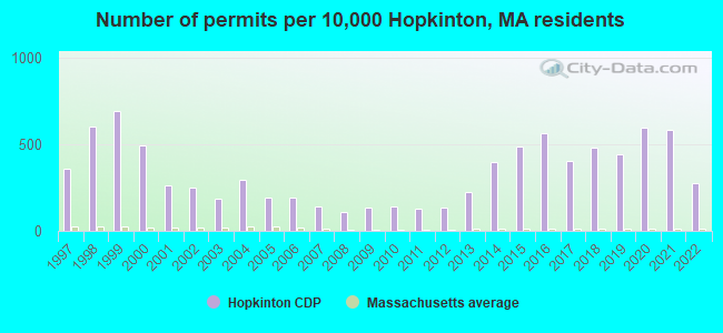
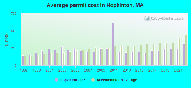
Single-family new house construction building permits:
- 2022: 72 buildings, average cost: $308,900
- 2021: 154 buildings, average cost: $242,300
- 2020: 157 buildings, average cost: $241,000
- 2019: 117 buildings, average cost: $236,000
- 2018: 127 buildings, average cost: $217,700
- 2017: 106 buildings, average cost: $217,600
- 2016: 148 buildings, average cost: $181,400
- 2015: 128 buildings, average cost: $201,000
- 2014: 104 buildings, average cost: $195,200
- 2013: 59 buildings, average cost: $191,100
- 2012: 36 buildings, average cost: $195,100
- 2011: 33 buildings, average cost: $617,800
- 2010: 37 buildings, average cost: $245,200
- 2009: 36 buildings, average cost: $247,300
- 2008: 29 buildings, average cost: $193,500
- 2007: 37 buildings, average cost: $196,900
- 2006: 51 buildings, average cost: $211,200
- 2005: 51 buildings, average cost: $237,400
- 2004: 78 buildings, average cost: $222,100
- 2003: 49 buildings, average cost: $273,600
- 2002: 65 buildings, average cost: $227,800
- 2001: 69 buildings, average cost: $236,200
- 2000: 129 buildings, average cost: $216,000
- 1999: 182 buildings, average cost: $179,200
- 1998: 159 buildings, average cost: $157,300
- 1997: 95 buildings, average cost: $144,700
| Here: | 3.0% |
| Massachusetts: | 3.5% |
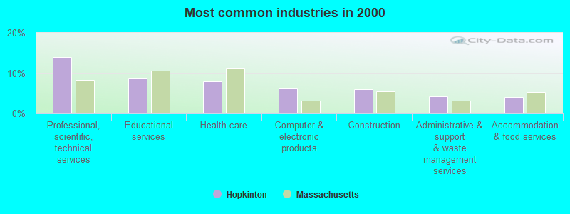
- Professional, scientific, technical services (13.9%)
- Educational services (8.6%)
- Health care (8.0%)
- Computer & electronic products (6.1%)
- Construction (5.9%)
- Administrative & support & waste management services (4.2%)
- Accommodation & food services (4.1%)
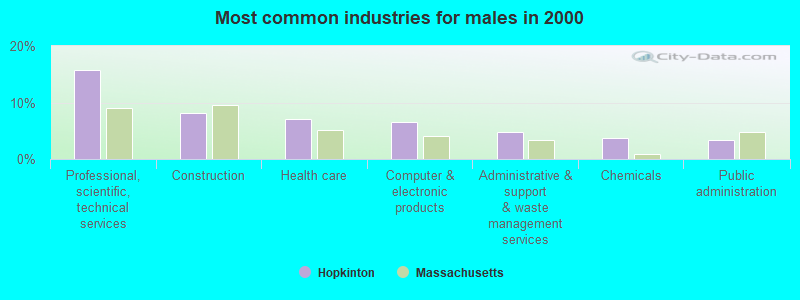
- Professional, scientific, technical services (15.8%)
- Construction (8.2%)
- Health care (7.0%)
- Computer & electronic products (6.5%)
- Administrative & support & waste management services (4.7%)
- Chemicals (3.7%)
- Public administration (3.3%)
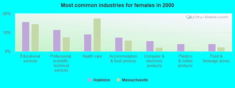
- Educational services (15.7%)
- Professional, scientific, technical services (11.5%)
- Health care (9.1%)
- Accommodation & food services (7.5%)
- Computer & electronic products (5.7%)
- Plastics & rubber products (4.0%)
- Food & beverage stores (4.0%)
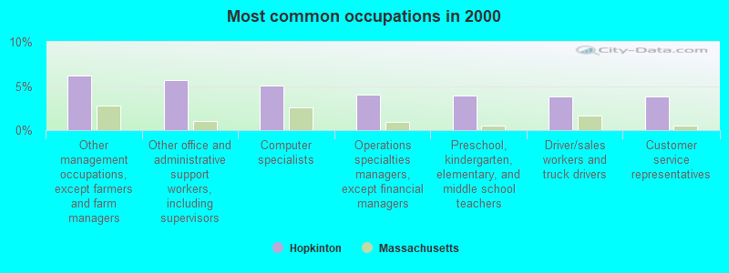
- Other management occupations, except farmers and farm managers (6.2%)
- Other office and administrative support workers, including supervisors (5.6%)
- Computer specialists (5.1%)
- Operations specialties managers, except financial managers (4.0%)
- Preschool, kindergarten, elementary, and middle school teachers (3.9%)
- Driver/sales workers and truck drivers (3.9%)
- Customer service representatives (3.9%)
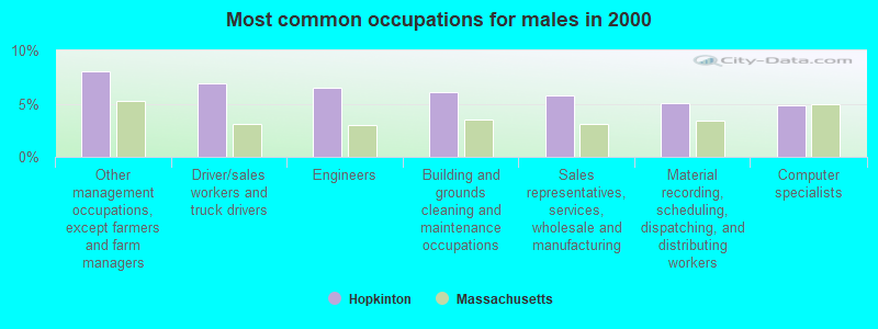
- Other management occupations, except farmers and farm managers (8.0%)
- Driver/sales workers and truck drivers (6.9%)
- Engineers (6.5%)
- Building and grounds cleaning and maintenance occupations (6.0%)
- Sales representatives, services, wholesale and manufacturing (5.7%)
- Material recording, scheduling, dispatching, and distributing workers (5.0%)
- Computer specialists (4.9%)
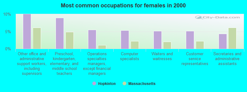
- Other office and administrative support workers, including supervisors (10.0%)
- Preschool, kindergarten, elementary, and middle school teachers (8.9%)
- Operations specialties managers, except financial managers (5.5%)
- Computer specialists (5.3%)
- Waiters and waitresses (5.1%)
- Customer service representatives (5.1%)
- Secretaries and administrative assistants (4.4%)
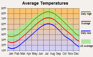
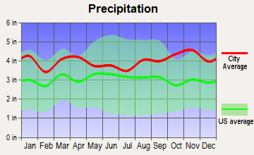
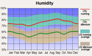
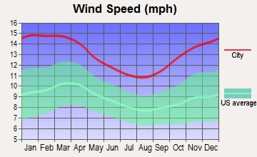
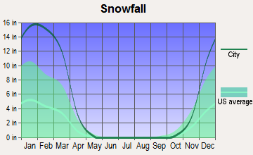
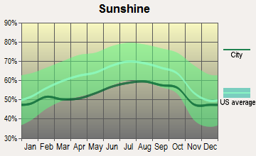
Average climate in Hopkinton, Massachusetts
Based on data reported by over 4,000 weather stations
|
|

(lower is better)
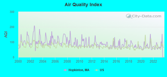
Air Quality Index (AQI) level in 2022 was 68.2. This is about average.
| City: | 68.2 |
| U.S.: | 72.6 |
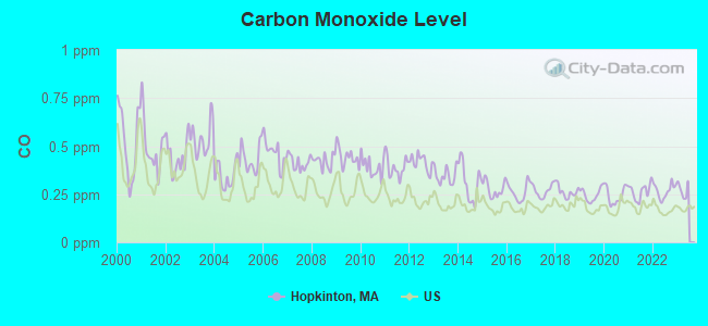
Carbon Monoxide (CO) [ppm] level in 2022 was 0.268. This is about average. Closest monitor was 14.3 miles away from the city center.
| City: | 0.268 |
| U.S.: | 0.251 |
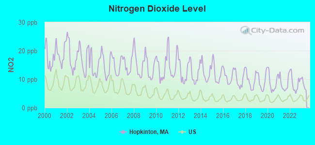
Nitrogen Dioxide (NO2) [ppb] level in 2022 was 8.71. This is significantly worse than average. Closest monitor was 7.4 miles away from the city center.
| City: | 8.71 |
| U.S.: | 5.11 |
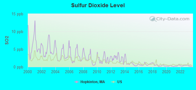
Sulfur Dioxide (SO2) [ppb] level in 2022 was 0.367. This is significantly better than average. Closest monitor was 3.7 miles away from the city center.
| City: | 0.367 |
| U.S.: | 1.515 |
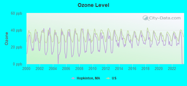
Ozone [ppb] level in 2022 was 29.2. This is about average. Closest monitor was 3.7 miles away from the city center.
| City: | 29.2 |
| U.S.: | 33.3 |
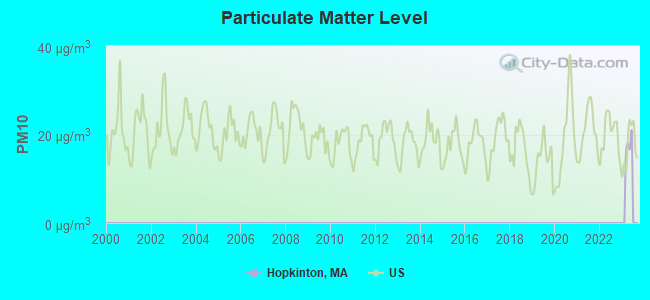
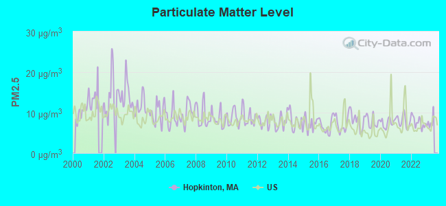
Particulate Matter (PM2.5) [µg/m3] level in 2022 was 7.63. This is about average. Closest monitor was 13.2 miles away from the city center.
| City: | 7.63 |
| U.S.: | 8.11 |
Tornado activity:
Hopkinton-area historical tornado activity is slightly above Massachusetts state average. It is 30% smaller than the overall U.S. average.
On 6/9/1953, a category F4 (max. wind speeds 207-260 mph) tornado 5.2 miles away from the Hopkinton place center killed 90 people and injured 1228 people and caused between $50,000,000 and $500,000,000 in damages.
On 6/9/1953, a category F3 (max. wind speeds 158-206 mph) tornado 13.4 miles away from the place center injured 17 people and caused between $500,000 and $5,000,000 in damages.
Earthquake activity:
Hopkinton-area historical earthquake activity is significantly above Massachusetts state average. It is 72% smaller than the overall U.S. average.On 10/7/1983 at 10:18:46, a magnitude 5.3 (5.1 MB, 5.3 LG, 5.1 ML, Class: Moderate, Intensity: VI - VII) earthquake occurred 186.0 miles away from Hopkinton center
On 4/20/2002 at 10:50:47, a magnitude 5.3 (5.3 ML, Depth: 3.0 mi) earthquake occurred 192.4 miles away from Hopkinton center
On 1/19/1982 at 00:14:42, a magnitude 4.7 (4.5 MB, 4.7 MD, 4.5 LG, Class: Light, Intensity: IV - V) earthquake occurred 88.3 miles away from the city center
On 4/20/2002 at 10:50:47, a magnitude 5.2 (5.2 MB, 4.2 MS, 5.2 MW, 5.0 MW) earthquake occurred 191.6 miles away from the city center
On 10/16/2012 at 23:12:25, a magnitude 4.7 (4.7 ML, Depth: 10.0 mi) earthquake occurred 104.5 miles away from Hopkinton center
On 8/22/1992 at 12:20:32, a magnitude 4.8 (4.8 MB, 3.8 MS, 4.7 LG, Depth: 6.2 mi) earthquake occurred 224.7 miles away from Hopkinton center
Magnitude types: regional Lg-wave magnitude (LG), body-wave magnitude (MB), duration magnitude (MD), local magnitude (ML), surface-wave magnitude (MS), moment magnitude (MW)
Natural disasters:
The number of natural disasters in Middlesex County (31) is a lot greater than the US average (15).Major Disasters (Presidential) Declared: 17
Emergencies Declared: 14
Causes of natural disasters: Floods: 12, Storms: 9, Hurricanes: 6, Snowstorms: 6, Winter Storms: 5, Blizzards: 2, Snows: 2, Explosion: 1, Heavy Rain: 1, Snowfall: 1, Water Main Break: 1, Wind: 1 (Note: some incidents may be assigned to more than one category).

Main business address for: CALIPER LIFE SCIENCES INC (LABORATORY ANALYTICAL INSTRUMENTS), EMC CORP (COMPUTER STORAGE DEVICES), VALPEY FISHER CORP (STEEL WORKS, BLAST FURNACES & ROLLING & FINISHING MILLS).
Hospitals and medical centers near Hopkinton:
- ASHLAND MANOR NH (Nursing Home, about 4 miles away; ASHLAND, MA)
- WHITTIER REHABILTATION HOSPITAL (Hospital, about 5 miles away; WESTBOROUGH, MA)
- FAMILY LIVES (Home Health Center, about 5 miles away; WESTBORO, MA)
- TIMOTHY DANIELS HOUSE (Nursing Home, about 6 miles away; HOLLISTON, MA)
- BETHANY SKILLED NURSING FACILITY (Nursing Home, about 6 miles away; FRAMINGHAM, MA)
- MILFORD CARE AND REHABILITATION CENTER (Nursing Home, about 6 miles away; MILFORD, MA)
- VNA AND HOSPICE OF GREATER MILFORD (Home Health Center, about 6 miles away; MILFORD, MA)
Heliports located in Hopkinton:
Amtrak stations near Hopkinton:
- 7 miles: FRAMINGHAM (443 WAVERLY ST.) . Services: public payphones, snack bar, paid short-term parking, taxi stand, public transit connection.
- 15 miles: WORCESTER (WORCHESTER, 45 SHREWSBURY ST.) . Services: ticket office, fully wheelchair accessible, enclosed waiting area, public restrooms, public payphones, vending machines, free short-term parking, free long-term parking, call for taxi service, public transit connection.
- 19 miles: ROUTE 128 (WESTWOOD, UNIVERSITY AVE. & RTE. 128) . Services: ticket office, enclosed waiting area, public restrooms, public payphones, vending machines, paid short-term parking, taxi stand, public transit connection.
Colleges/universities with over 2000 students nearest to Hopkinton:
- Framingham State University (about 7 miles; Framingham, MA; Full-time enrollment: 5,743)
- Wellesley College (about 12 miles; Wellesley, MA; FT enrollment: 2,658)
- Babson College (about 14 miles; Wellesley, MA; FT enrollment: 3,230)
- Massachusetts Bay Community College (about 15 miles; Wellesley Hills, MA; FT enrollment: 3,636)
- College of the Holy Cross (about 15 miles; Worcester, MA; FT enrollment: 3,125)
- Worcester Polytechnic Institute (about 16 miles; Worcester, MA; FT enrollment: 3,930)
- Quinsigamond Community College (about 16 miles; Worcester, MA; FT enrollment: 5,877)
Public high school in Hopkinton:
- HOPKINTON HIGH (Students: 927, Location: 90 HAYDEN ROWE STREET, Grades: 9-12)
Public elementary/middle schools in Hopkinton:
- HOPKINTON MIDDLE SCHOOL (Students: 812, Location: 88 HAYDEN ROWE STREET, Grades: 6-8)
- HOPKINS ELEMENTARY SCHOOL (Students: 594, Location: 104 HAYDEN ROWE STREET, Grades: 4-5)
- ELMWOOD (Students: 538, Location: 14 ELM STREET, Grades: 2-3)
- CENTER (Students: 486, Location: 11 ASH STREET, Grades: KG-1)
User-submitted facts and corrections:
- Lakes include: Lake Maspenock (North Pond), Lake Whitehall, Echo Lake, Hopkinton Reservoir. Parks include: Hopkinton State Park, Whitehall, EMC Park, and town conservation areas.
Points of interest:
Notable locations in Hopkinton: Old Stone Tavern (A), Hopkinton Fire Department Headquarters (B), Hopkinton Public Library (C), Hopkinton Town Hall (D). Display/hide their locations on the map
Churches in Hopkinton include: Vineyard Church of Hopkinton (A), Saint John the Evangelist Church (B), Korean Presbyterian Church (C), First Congregational Church (D). Display/hide their locations on the map
Lake: Icehouse Pond (A). Display/hide its location on the map
Parks in Hopkinton include: Berry Acres Conservation Area (1), Carrigan Park (2). Display/hide their locations on the map
Tourist attraction: Hopkinton Historical Society (Historical Places & Services; 168 Hayden Rowe Street).
Birthplace of: Frank Merrill - Recipient of the Purple Heart medal, Joseph Young - Mormon missionary, M. Laurance Morse - Microbiologist, Phineas Young - Mormon missionary, Abbott Barnes Rice - Politician, Levi Richards - Mormon missionary.
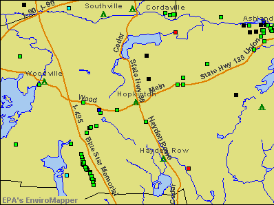
Drinking water stations with addresses in Hopkinton and their reported violations in the past:
HOPKINTON WATER DEPARTMENT (Population served: 8,901, Groundwater):Past health violations:THE PRESERVE AT HOPKINTON CONDO (Population served: 80, Groundwater):Past monitoring violations:
- MCL, Monthly (TCR) - In SEP-2008, Contaminant: Coliform. Follow-up actions: St AO (w/o penalty) issued (NOV-05-2008), St Compliance achieved (NOV-05-2008)
- MCL, Monthly (TCR) - In OCT-2006, Contaminant: Coliform. Follow-up actions: St AO (w/o penalty) issued (NOV-14-2006), St Compliance achieved (NOV-14-2006)
- MCL, Monthly (TCR) - In FEB-2005, Contaminant: Coliform. Follow-up actions: St AO (w/o penalty) issued (MAR-22-2005), St Compliance achieved (MAR-22-2005)
- One regular monitoring violation
Past health violations:MAILLET WOODS CONDOMINIUMS (Address: 19 TREVOR LANE , Population served: 75, Groundwater):Past monitoring violations:
- MCL, Average - Between JAN-2012 and MAR-2012, Contaminant: Gross Alpha, Excl. Radon and U. Follow-up actions: St AO (w/o penalty) issued (MAY-07-2012)
- MCL, Average - Between OCT-2011 and DEC-2011, Contaminant: Gross Alpha, Excl. Radon and U. Follow-up actions: St AO (w/o penalty) issued (FEB-08-2012), St Compliance achieved (MAR-18-2013)
- MCL, Average - Between JUL-2011 and SEP-2011, Contaminant: Gross Alpha, Excl. Radon and U. Follow-up actions: St AO (w/o penalty) issued (NOV-04-2011), St Compliance achieved (MAR-18-2013)
- MCL, Average - Between APR-2011 and JUN-2011, Contaminant: Gross Alpha, Excl. Radon and U. Follow-up actions: St AO (w/o penalty) issued (NOV-04-2011), St Compliance achieved (MAR-18-2013)
- 2 regular monitoring violations
Past monitoring violations:VILLAGE AT HIGHLAND PARK (Population served: 50, Groundwater):
- Follow-up Or Routine LCR Tap M/R - In APR-01-2009, Contaminant: Lead and Copper Rule. Follow-up actions: St AO (w/o penalty) issued (SEP-03-2009), St Compliance achieved (JUN-30-2010)
- One routine major monitoring violation
- 63 regular monitoring violations
Past health violations:
- MCL, Monthly (TCR) - In SEP-2013, Contaminant: Coliform. Follow-up actions: St AO (w/o penalty) issued (OCT-25-2013)
- MCL, Acute (TCR) - In SEP-2012, Contaminant: Coliform. Follow-up actions: St AO (w/o penalty) issued (SEP-14-2012)
- MCL, Monthly (TCR) - In SEP-2012, Contaminant: Coliform. Follow-up actions: St AO (w/o penalty) issued (SEP-14-2012)
- MCL, Monthly (TCR) - In AUG-2012, Contaminant: Coliform. Follow-up actions: St AO (w/o penalty) issued (SEP-14-2012)
| This place: | 2.5 people |
| Massachusetts: | 2.5 people |
| This place: | 65.0% |
| Whole state: | 63.0% |
| This place: | 4.1% |
| Whole state: | 7.0% |
Likely homosexual households (counted as self-reported same-sex unmarried-partner households)
- Lesbian couples: 0.2% of all households
- Gay men: 0.1% of all households
7 people in residential treatment centers for juveniles (non-correctional) in 2010
99 people in nursing homes in 2000
Banks with branches in Hopkinton (2011 data):
- Middlesex Savings Bank: Hopkinton Branch at 10 Main Street, branch established on 1867/01/01; Hopkinton Branch at 59 Main Street, branch established on 1999/06/10. Info updated 2009/07/16: Bank assets: $4,034.8 mil, Deposits: $3,490.0 mil, headquarters in Natick, MA, positive income, Mortgage Lending Specialization, 33 total offices, Holding Company: Middlesex Bancorp Mhc
- Sovereign Bank, National Association: Hopkinton Branch at 66 Main Street, branch established on 1960/05/09. Info updated 2012/01/31: Bank assets: $78,146.9 mil, Deposits: $48,042.9 mil, headquarters in Wilmington, DE, positive income, Commercial Lending Specialization, 718 total offices, Holding Company: Banco Santander, S.A.
- Bank of America, National Association: Hopkinton Branch at 77 West Main Street, branch established on 1979/06/04. Info updated 2009/11/18: Bank assets: $1,451,969.3 mil, Deposits: $1,077,176.8 mil, headquarters in Charlotte, NC, positive income, 5782 total offices, Holding Company: Bank Of America Corporation
For population 15 years and over in Hopkinton:
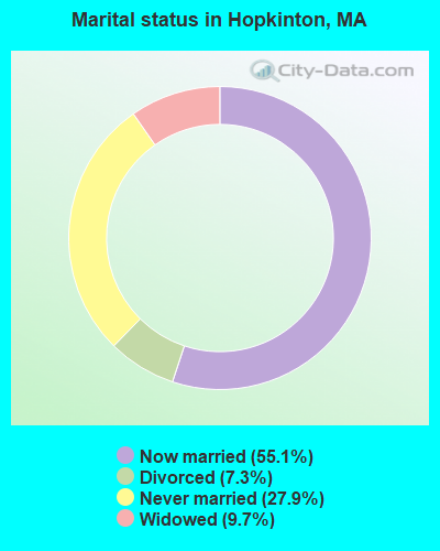
- Never married: 27.9%
- Now married: 55.1%
- Separated: 0.0%
- Widowed: 9.7%
- Divorced: 7.3%
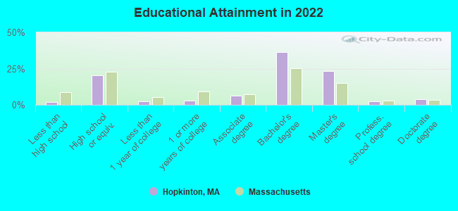
For population 25 years and over in Hopkinton:
- High school or higher: 98.2%
- Bachelor's degree or higher: 65.2%
- Graduate or professional degree: 29.4%
- Unemployed: 1.1%
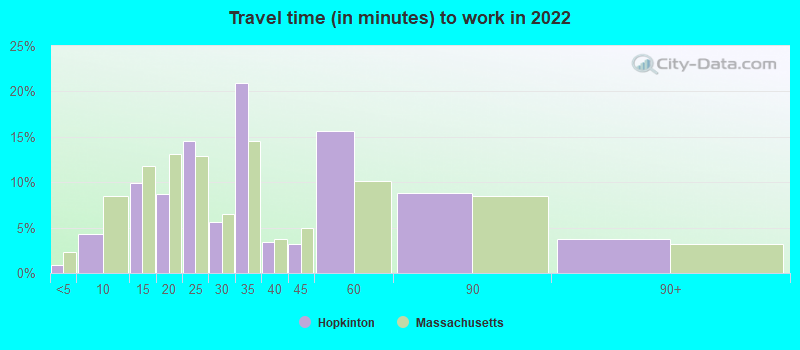
- Mean travel time to work (commute): 27.5 minutes
| Here: | 10.0 |
| Massachusetts average: | 13.0 |


Graphs represent county-level data. Detailed 2008 Election Results
Religion statistics for Hopkinton, MA (based on Middlesex County data)


| Religion | Adherents | Congregations |
|---|---|---|
| Catholic | 718,209 | 107 |
| Mainline Protestant | 70,053 | 269 |
| Other | 68,480 | 199 |
| Evangelical Protestant | 41,270 | 304 |
| Orthodox | 23,641 | 28 |
| Black Protestant | 2,276 | 8 |
| None | 579,156 | - |
Food Environment Statistics:
| Middlesex County: | 1.71 / 10,000 pop. |
| Massachusetts: | 1.98 / 10,000 pop. |
| Middlesex County: | 0.03 / 10,000 pop. |
| Massachusetts: | 0.05 / 10,000 pop. |
| Middlesex County: | 2.14 / 10,000 pop. |
| State: | 2.22 / 10,000 pop. |
| Middlesex County: | 1.38 / 10,000 pop. |
| Massachusetts: | 1.77 / 10,000 pop. |
| Here: | 7.84 / 10,000 pop. |
| Massachusetts: | 8.76 / 10,000 pop. |
| Here: | 7.8% |
| Massachusetts: | 8.1% |
| This county: | 21.5% |
| State: | 22.5% |
| This county: | 18.0% |
| State: | 16.5% |
Health and Nutrition:
| This city: | 52.4% |
| Massachusetts: | 50.5% |
| Here: | 51.9% |
| Massachusetts: | 48.0% |
| Hopkinton: | 28.6 |
| Massachusetts: | 28.4 |
| Hopkinton: | 21.5% |
| Massachusetts: | 20.7% |
| This city: | 8.5% |
| State: | 10.4% |
| Here: | 6.9 |
| State: | 6.8 |
| This city: | 35.9% |
| Massachusetts: | 33.4% |
| Here: | 58.5% |
| Massachusetts: | 57.1% |
| This city: | 79.1% |
| Massachusetts: | 79.2% |
More about Health and Nutrition of Hopkinton, MA Residents
6.91% of this county's 2021 resident taxpayers lived in other counties in 2020 ($102,955 average adjusted gross income)
| Here: | 6.91% |
| Massachusetts average: | 6.35% |
0.01% of residents moved from foreign countries ($137 average AGI)
Middlesex County: 0.01% Massachusetts average: 0.01%
Top counties from which taxpayers relocated into this county between 2020 and 2021:
| from Suffolk County, MA | |
| from Essex County, MA | |
| from Norfolk County, MA |
8.22% of this county's 2020 resident taxpayers moved to other counties in 2021 ($123,369 average adjusted gross income)
| Here: | 8.22% |
| Massachusetts average: | 7.18% |
0.01% of residents moved to foreign countries ($124 average AGI)
Middlesex County: 0.01% Massachusetts average: 0.02%
Top counties to which taxpayers relocated from this county between 2020 and 2021:
| to Suffolk County, MA | |
| to Essex County, MA | |
| to Worcester County, MA |
| Businesses in Hopkinton, MA | ||||
| Name | Count | Name | Count | |
|---|---|---|---|---|
| Curves | 1 | Subway | 1 | |
| Dunkin Donuts | 2 | UPS | 3 | |
| FedEx | 3 | YMCA | 1 | |
| Nike | 1 | |||
Strongest AM radio stations in Hopkinton:
- WAMG (890 AM; 25 kW; DEDHAM, MA; Owner: MEGA COMMUNICATIONS OF DEDHAM LICENSEE, LLC)
- WKOX (1200 AM; 50 kW; FRAMINGHAM, MA; Owner: CAPSTAR TX LIMITED PARTNERSHIP)
- WBIX (1060 AM; 40 kW; NATICK, MA; Owner: LANGER BROADCASTING CORPORATION)
- WEEI (850 AM; 50 kW; BOSTON, MA; Owner: ENTERCOM BOSTON LICENSE, LLC)
- WALE (990 AM; 50 kW; GREENVILLE, RI; Owner: NORTH AMERICAN BROADCASTING CO., INC.)
- WCRN (830 AM; 50 kW; WORCESTER, MA; Owner: CARTER BROADCASTING CORPORATION)
- WRKO (680 AM; 50 kW; BOSTON, MA; Owner: ENTERCOM BOSTON LICENSE, LLC)
- WSRO (650 AM; 2 kW; ASHLAND, MA; Owner: LANGER BROADCASTING GROUP, LLC)
- WWZN (1510 AM; 50 kW; BOSTON, MA; Owner: ROSE CITY RADIO CORPORATION)
- WRCA (1330 AM; 25 kW; WALTHAM, MA; Owner: WRCA LICENSE, LLC)
- WBZ (1030 AM; 50 kW; BOSTON, MA; Owner: INFINITY BROADCASTING OPERATIONS, INC.)
- WUNR (1600 AM; 20 kW; BROOKLINE, MA; Owner: CHAMPION BROADCASTING SYSTEMS, INC.)
- WVNE (760 AM; daytime; 25 kW; LEICESTER, MA; Owner: BLOUNT MASSCOM, INC.)
Strongest FM radio stations in Hopkinton:
- WBMX (98.5 FM; BOSTON, MA; Owner: INFINITY RADIO OPERATIONS INC.)
- WJMN (94.5 FM; BOSTON, MA; Owner: AMFM RADIO LICENSES, L.L.C.)
- WCRB (102.5 FM; WALTHAM, MA; Owner: CHARLES RIVER BROADCASTING WCRB LICE)
- WTKK (96.9 FM; BOSTON, MA; Owner: GREATER BOSTON RADIO, INC.)
- WROR-FM (105.7 FM; FRAMINGHAM, MA; Owner: GREATER BOSTON RADIO, INC.)
- WBOS (92.9 FM; BROOKLINE, MA; Owner: GREATER BOSTON RADIO, INC.)
- WGBH (89.7 FM; BOSTON, MA; Owner: WGBH EDUCATIONAL FOUNDATION)
- WHHB (99.9 FM; HOLLISTON, MA; Owner: HOLLISTON HIGH SCHOOL)
- WBUR-FM (90.9 FM; BOSTON, MA; Owner: TRUSTEES OF BOSTON UNIVERSITY)
- WODS (103.3 FM; BOSTON, MA; Owner: INFINITY BROADCASTING OPERATIONS, INC.)
- WAAF (107.3 FM; WORCESTER, MA; Owner: ENTERCOM BOSTON LICENSE, LLC)
- WXKS-FM (107.9 FM; MEDFORD, MA; Owner: AMFM RADIO LICENSES, L.L.C.)
- WMJX (106.7 FM; BOSTON, MA; Owner: GREATER BOSTON RADIO, INC.)
- WSRS (96.1 FM; WORCESTER, MA; Owner: CAPSTAR TX LIMITED PARTNERSHIP)
- WICN (90.5 FM; WORCESTER, MA; Owner: WICN PUBLIC RADIO, INC)
- WWBB (101.5 FM; PROVIDENCE, RI; Owner: CLEAR CHANNEL BROADCASTING LICENSES, INC.)
- WBCN (104.1 FM; BOSTON, MA; Owner: HEMISPHERE BROADCASTING CORPORATION)
- WZLX (100.7 FM; BOSTON, MA; Owner: INFINITY BROADCASTING CORPORATION OF BOSTON)
- WWKX (106.3 FM; WOONSOCKET, RI; Owner: AAA ENTERTAINMENT LICENSING LLC)
- W267AI (101.3 FM; BOSTON, MA; Owner: MCC BROADCASTING COMPANY, INC.)
TV broadcast stations around Hopkinton:
- WUTF (Channel 66; MARLBOROUGH, MA; Owner: TELEFUTURA BOSTON LLC)
- WUNI (Channel 27; WORCESTER, MA; Owner: ENTRAVISION HOLDINGS, LLC)
- WCVB-TV (Channel 5; BOSTON, MA; Owner: WCVB HEARST-ARGYLE TV, INC.)
- WGBH-TV (Channel 2; BOSTON, MA; Owner: WGBH EDUCATIONAL FOUNDATION)
- WBZ-TV (Channel 4; BOSTON, MA; Owner: VIACOM INC.)
- WGBX-TV (Channel 44; BOSTON, MA; Owner: WGBH EDUCATIONAL FOUNDATION)
- WMFP (Channel 62; LAWRENCE, MA; Owner: WSAH LICENSE, INC.)
- WHDH-TV (Channel 7; BOSTON, MA; Owner: WHDH-TV)
- WSBK-TV (Channel 38; BOSTON, MA; Owner: VIACOM INC.)
- WLVI-TV (Channel 56; CAMBRIDGE, MA; Owner: WLVI, INC.)
- WFXT (Channel 25; BOSTON, MA; Owner: FOX TELEVISION STATIONS INC.)
- W40BO (Channel 40; BOSTON, MA; Owner: PAXSON COMMUNICATIONS LPTV, INC.)
- WBPX (Channel 68; BOSTON, MA; Owner: PAXSON BOSTON-68 LICENSE, INC.)
- WWDP (Channel 46; NORWELL, MA; Owner: NORWELL TELEVISION, LLC)
- WTMU-LP (Channel 32; BOSTON, MA; Owner: ZGS BOSTON, INC.)
- WNAC-TV (Channel 64; PROVIDENCE, RI; Owner: WNAC, LLC)
- WCEA-LP (Channel 58; BOSTON, MA; Owner: CHANNEL 19 TV CORPORATION)
- WPRI-TV (Channel 12; PROVIDENCE, RI; Owner: TVL BROADCASTING OF RHODE ISLAND, LLC)
- WLNE-TV (Channel 6; NEW BEDFORD, MA; Owner: FREEDOM BROADCASTING OF SOUTHERN NEW ENGLAND, INC.)
- WJAR (Channel 10; PROVIDENCE, RI; Owner: OUTLET BROADCASTING, INC.)
- WYDN (Channel 48; WORCESTER, MA; Owner: EDUCATIONAL PUBLIC TV CORPORATION)
- WPXQ (Channel 69; BLOCK ISLAND, RI; Owner: OCEAN STATE TELEVISION, L.L.C.)
- WSBE-TV (Channel 36; PROVIDENCE, RI; Owner: RHODE ISLAND PUBLIC TELECOM. AUTHORITY)
- WFXZ-CA (Channel 24; BOSTON, MA; Owner: BOSTON BROADCASTING CORP.)
- WCRN-LP (Channel 34; LEICESTER, MA; Owner: CARTER BROADCASTING CORPORATION)
- National Bridge Inventory (NBI) Statistics
- 4Number of bridges
- 39ft / 12.0mTotal length
- $12,943,000Total costs
- 212,482Total average daily traffic
- 18,426Total average daily truck traffic
- 470,344Total future (year 2031) average daily traffic
FCC Registered Antenna Towers: 32 (See the full list of FCC Registered Antenna Towers)
FCC Registered Private Land Mobile Towers: 4 (See the full list of FCC Registered Private Land Mobile Towers in Hopkinton, MA)
FCC Registered Broadcast Land Mobile Towers: 14 (See the full list of FCC Registered Broadcast Land Mobile Towers)
FCC Registered Microwave Towers: 7 (See the full list of FCC Registered Microwave Towers in this town)
FCC Registered Paging Towers: 3 (See the full list of FCC Registered Paging Towers)
FCC Registered Amateur Radio Licenses: 65 (See the full list of FCC Registered Amateur Radio Licenses in Hopkinton)
FAA Registered Aircraft: 16 (See the full list of FAA Registered Aircraft in Hopkinton)
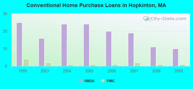
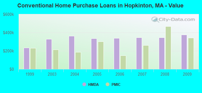
| Home Mortgage Disclosure Act Aggregated Statistics For Year 2009 (Based on 1 partial tract) | ||||||||
| A) FHA, FSA/RHS & VA Home Purchase Loans | B) Conventional Home Purchase Loans | C) Refinancings | D) Home Improvement Loans | |||||
|---|---|---|---|---|---|---|---|---|
| Number | Average Value | Number | Average Value | Number | Average Value | Number | Average Value | |
| LOANS ORIGINATED | 3 | $280,403 | 10 | $375,517 | 54 | $309,912 | 2 | $170,300 |
| APPLICATIONS APPROVED, NOT ACCEPTED | 0 | $0 | 1 | $197,080 | 3 | $254,243 | 0 | $0 |
| APPLICATIONS DENIED | 0 | $0 | 1 | $298,130 | 6 | $370,932 | 0 | $0 |
| APPLICATIONS WITHDRAWN | 0 | $0 | 1 | $251,530 | 7 | $325,117 | 0 | $0 |
| FILES CLOSED FOR INCOMPLETENESS | 0 | $0 | 0 | $0 | 3 | $317,060 | 0 | $0 |
Detailed HMDA statistics for the following Tracts: 3201.01
| Private Mortgage Insurance Companies Aggregated Statistics For Year 2009 (Based on 1 partial tract) | ||||
| A) Conventional Home Purchase Loans | B) Refinancings | |||
|---|---|---|---|---|
| Number | Average Value | Number | Average Value | |
| LOANS ORIGINATED | 1 | $343,450 | 1 | $356,590 |
| APPLICATIONS APPROVED, NOT ACCEPTED | 0 | $0 | 0 | $0 |
| APPLICATIONS DENIED | 0 | $0 | 0 | $0 |
| APPLICATIONS WITHDRAWN | 0 | $0 | 0 | $0 |
| FILES CLOSED FOR INCOMPLETENESS | 0 | $0 | 0 | $0 |
Detailed PMIC statistics for the following Tracts: 3201.01
2002 - 2018 National Fire Incident Reporting System (NFIRS) incidents
- Fire incident types reported to NFIRS in Hopkinton, MA
- 59852.2%Structure Fires
- 32328.2%Outside Fires
- 18015.7%Mobile Property/Vehicle Fires
- 453.9%Other
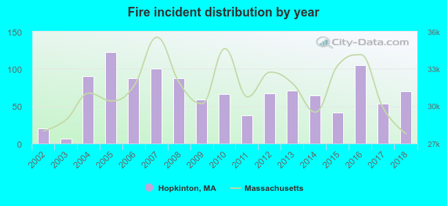 According to the data from the years 2002 - 2018 the average number of fires per year is 67. The highest number of reported fires - 122 took place in 2005, and the least - 6 in 2003. The data has a rising trend.
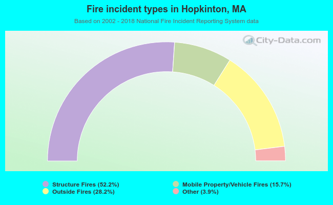 When looking into fire subcategories, the most reports belonged to: Structure Fires (52.2%), and Outside Fires (28.2%).
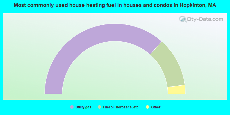
- 73.2%Utility gas
- 22.8%Fuel oil, kerosene, etc.
- 3.0%Electricity
- 1.0%Bottled, tank, or LP gas
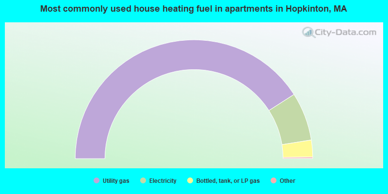
- 82.1%Utility gas
- 13.2%Electricity
- 4.6%Bottled, tank, or LP gas
Hopkinton compared to Massachusetts state average:
- Median household income above state average.
- Unemployed percentage significantly below state average.
- Black race population percentage significantly below state average.
- Hispanic race population percentage significantly below state average.
- Foreign-born population percentage significantly below state average.
- Length of stay since moving in significantly above state average.
- Number of rooms per house above state average.
- Institutionalized population percentage above state average.
- Percentage of population with a bachelor's degree or higher above state average.
Hopkinton on our top lists:
- #90 on the list of "Top 101 cities with the most residents born in Ukraine (population 500+)"
- #4 on the list of "Top 101 counties with the most Orthodox adherents"
- #7 on the list of "Top 101 counties with the most Catholic adherents"
- #7 on the list of "Top 101 counties with the most Mainline Protestant congregations"
- #7 on the list of "Top 101 counties with the most Orthodox congregations"
- #8 on the list of "Top 101 counties with the lowest percentage of residents that keep firearms around their homes"

|
|
Total of 1107 patent applications in 2008-2024.